Main Range Walk - Charlotte Pass to Mount Kosciuszko Builder

9 hrs

21.9 kms

920 m

Normal track
This full day walk explores some of the greatest alpine country on offer in NSW. The walk grants views of Blue, Club and Albina Lakes, climbs to the top of Mt Kosciuszko and crosses the famous Snowy River twice. This main range circuit is one of the classic walks in New South Wales, as the views in clear weather extend all the way over the mountainous landscape to the distant horizon. If you want to stay overnight there is a flat area for camping at Wilkinsons Creek, described as a side trip.
Covered in snow part of the year

This walk leads through an extreme alpine environment and all walkers must be well prepared. During summer, be prepared for both very hot and cold weather, high winds, rain, snow, extreme UV levels and some sections of snow or ice on the ground. Before starting this walk, check advice with Snowy Region Visitor Information Centre (02) 6450 5600, the weather forecast and the snow conditions then change your plans as needed. These notes, grades and walking times have been written for use in the summer months only. Between May and the end of October, this walk is likely to be covered in snow/ice, visitors should carry and be prepared to use snowshoes or cross country skis. When there is a chance of significant snow on the ground, visitors will need particularly strong navigation and snowcraft skills - tracks and signage may not be visible. For most visitors, it is best to consider this walk closed during the colder months.
Between the long weekend in June and October, the road between Perisher Village and Charlotte Pass is closed by the RTA. It is possible to organise oversnow transport.
End of Kosciuszko Road to Snowy River crossing

785 m
18 mins
1 m
-122 m
Track Notes
From Charlotte Pass[1] (at the turning circle at the end of Kosciuszko Rd), this walk follows the 'Main Range Track' - 'Blue Lake Lookout' sign[2] downhill along the wide paved path[3]. The walk winds down past the stone path[4] (on your right) and continues beside the 'Glaciers shaped this ancient landscape' information sign[5]. The path continues down through lightly scattered snow gums to the bottom of the valley, approximately 650m further. Just past the 'From the mountains to the sea' information sign[6], this walk crosses the Snowy River using the stepping stones[7] and comes to a strip of land between the two creeks[8]. (Crossing the river is dangerous and is not advisable when the water is flowing over the stepping stones[9]).
Snowy River crossing

At the lowest point of the the Main Range circuit track is the confluence (meeting) of the Snowy River and Club Lake Creek. The walking track uses stones in the river to try to get across with dry feet. Since the track crosses just above the confluence there is an 'island'[10] halfway across. These creeks may become impassable after rain and snow melt. This is lovely place to rest and enjoy the water and valley.
Snowy River crossing to Int of Main Range and Blue Lake Lookout tracks

-33 m
1hr:7mins
3.23 km
306 m
Track: Hard - bushtrack
Veer right: From between the two creeks, this walk heads north along the wide track to cross Club Lake Creek using the stepping stones. (The creek may not be safe to cross when water covers the stepping stones[11]). The walk then follows the wide, paved track fairly steeply up the hill. After a short time, the track becomes gravel and continues up the hill for about 400m further before passing a 'Mountains of Soil' information sign[12], where the track soon becomes less steep. After about 1.5km, the track passes a 'Created by glaciers' information sign[13] and reveals some views down to Hedley Tarn[14] (on your right). The track continues up the hill and between the granite boulders[15] to then head down the other side of the ridge[16]. The walk leads down to rock-hop across Carruthers Creek[17], then follows the wide, paved path up the hill, passing the 'Remnants of an ancient sea' information sign[18] and coming to a paved area[19], with a view to Blue Lake[20] and some information signs marking a three-way intersection.
Int of Main Range and Blue Lake Lookout tracks to Blue Lake lookout

-72 m
14 mins
643 m
8 m
Optional sidetrip: Track: Hard - bushtrack
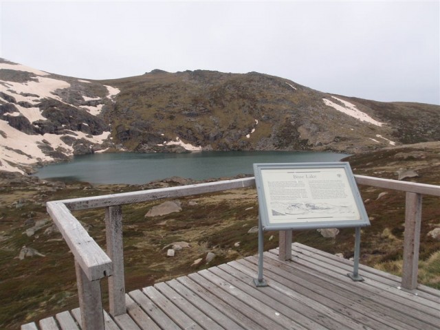
Turn right: From the paved area[21], this walk follows the dirt track next to the stone seat, heading east towards Blue Lake[22]. The rocky track winds down and around the northern side of the ridge[23] to a platform[24] with an information sign[25] and a fantastic view of Blue Lake[26].
(Retrace your steps back to the main track, then veer right to continue along this walk.)
Blue Lake

Blue Lake is the best example of a glacial lake in the alpine area. At 28m deep, this lake was formed when glaciers, flowing from the Great Dividing Range, converged and carved out a basin in the rock. This is visible in the cliffs behind the lake, where the glaciers have plucked out blocks of stone and carried them away. There is also a stream that flows from Blue lake, feeding Hedley Tarn just to the south.
Int of Main Range and Blue Lake Lookout tracks to Int of Main Range and Mt Twynam tracks

-7 m
17 mins
881 m
60 m
Track: Hard - bushtrack
Turn left: From the intersection, this walk heads west, uphill[27] away from Blue Lake[28]. The walk initially heads along a short section of paved path before continuing along the wide gravel track[29]. The track winds gently uphill for a while, keeping the wide valley to your left. The walk comes to a saddle and a three-way intersection, marked with a 'Main Range Track' signpost[30]
Int of Main Range and Mt Twynam tracks to Carruthers Peak

-2 m
18 mins
862 m
99 m
Track: Hard - bushtrack
Continue straight: From the intersection, this walk follows the 'Main Range Track' sign[31] across the saddle then uphill along the clear track. The track winds up along the ridge and in time comes to a rocky clearing on the eastern side of Carruthers Peak[32](where a short detour will reveal views down to Club Lake). Here the walk bends right and follows the clear track as it winds up the hill[33] to the views at the top of Carruthers Peak[34].
Carruthers Peak

Carruthers Peak is a prominent mountain that is found along the Main Range track, from which you can see great views down over Club Lake and out across the valley to Charlotte Pass. Carruthers Peak was named after the NSW Minister for Lands and Premier, Joseph Carruthers. This name was given in 1991 by Richard Helms, who had previously named it Crummer.
Carruthers Peak to Int of Main Range and Muellers Peak track

-235m
1hr
29mins
4.22km
105m
Track: Hard - bushtrack
Continue straight: From the top of Carruthers Peak, this walk follows the clear track west as it winds down the ridge[35]. After about 50m, the track passes an 'I30' survey marker[36] (more good views) where the track bends left and follows the stone path and steps down the hill[37]. At the end of the stone path, the track bends left and heads down the hill[38], over a few lengths of metal grate[39] and comes to a saddle with good views down to Club Lake[40] (on your left). The walk then continues across the saddle, following the clear track to soon pass the 'Rarest Alpine Plant Community' information sign[41]. Heading around the side of the hill (keeping the valley to your right), the walk then comes to another rocky saddle[42]. About 320m beyond this saddle, this track leads to a very faint intersection where the ridge[43] (that leads to the northern end of Albina Lake) on the right meets the main track.
Continue straight: From the intersection, the walk follows the gravel Main Range track south, keeping the valley and Albina Lake to your right. The track heads downhill[44] and then winds around beside a rocky saddle (a short side trip to the left over the small rise reveals some views into the valley). This walk continues along the clear track as it traverses fairly gently around the side of the very steep hill. In a few places, the track has been cut into the rock[45] and provides great views down into the Albina Lake - take care not to slip. The walk continues to another large saddle and just as the track starts to dip down past the saddle, the track comes to a faint intersection with an old management trail[46] (leading to Lake Albina, on your right).
Continue straight: From the intersection, the walk follows the rock-paved Main Range track south[47]. The track steadily winds around the side of the hill (keeping the large valley to your left). After heading between a rocky outcrop[48], the track becomes gravel[49] and starts to head over the ridge before gently winding down the hill. Just before flattening out on the large saddle, the track comes to a faint intersection (with the Muellers Peak and Mt Townsend tracks on your right) marked with a rock cairn[50](on your right).
Int of Main Range and Muellers Peak track to Int of Main Range and Wilkinsons Creek track

-7 m
4 mins
203 m
3 m
Track: Hard - bushtrack
Veer left: From the intersection, this walk heads south along the main track to the low point in the saddle[51] (where there is a faint intersection with a pad leading down to Wilkinsons Creek on your right).
Int of Main Range and Wilkinsons creek track to Wilkinsons creek

-94 m
16 mins
779 m
1 m
Route: Hard - undefined
Turn right: From the low point in the saddle[52], this walk heads west, off the main track, over the grassy rise. Soon finding an overgrown management trail that leads down towards the creek at the bottom of the valley. The walk continues down the side of the hill passing through some low scrub to find many boulders and flat areas[53] beside Wilkinsons Creek[54].
(Retrace your steps back to the main track, then turn right to continue along this walk.)
Wilkinsons Creek

Wilkinsons Creek meanders through a beautiful and broad valley. Nestled in the valley between Mt Kosciuszko and Mt Townsend, this is a great spot to cool down or camp for a night. The large, flat, grassy plain, with a scattering of boulders, makes this great place to stay, although can be pretty exposed to westerly winds. You can often get great sunset views from the rocks at the western end. There are no facilities, please remember to use minimal impact techniques when visiting this area. Water is available from the creek. Camp more than 100m from the creek, and if staying for more than a day or two, move your camp to minimise the risk of damage. No fires - use fuel stoves only (there are a few gravelly areas to set your stove up to avoid destroying the grass).
Int of Main Range and Wilkinsons Creek track to Int of Main Range track and Kosciuszko walk

-2 m
38 mins
1.45 km
159 m
Track: Hard - bushtrack
Continue straight: From the intersection[55], this walk heads south along the clear track, climbing up out of the saddle and along the side of the hill, keeping the valley to your left. The walk heads up many stone steps[56] for about 600m, then flattens out for a little while[57] before coming to a clear and signposted three-way intersection[58]. (Here, the track on the right leads up to the summit of Mt Kosciuszko.)
Int of Main Range track and Kosciuszko path to Mt Kosciuszko

-15 m
23 mins
972 m
76 m
Track: Hard - footpath
Turn sharp right: From the intersection, this walk follows the 'Mt Kosciuszko' sign[59] uphill along the upper track. This track winds steadily up and around the peak of the mountain, passing a stone-paved[60] section of track, and also a metal grate[61]before climbing a few steps[62] to the cairn at the peak of Mt Kosciuszko[63].
Mt Kosciuszko

Mt Kosciuszko is the highest peak on the Australian continent, at 2228m above sea level. It was named by the Polish explorer Count Paul Edmund Strzelecki and named in honour of the Polish national hero General Tadeusz Kosciuszko. Now a popular tourist attraction, thousands of people walk up to the summit each year. On a clear day, the 360-degree views from the summit across the roof of Australia are fantastic. There are higher mountains elsewhere on Australian territory. 'The highest mountains in Australian Antarctic Territory are Mt McClintock (3490 meters) and Mt Menzies (3355 meters).' [64].
Mt Kosciuszko to Rawson Pass

-127 m
39 mins
1.65 km
23 m
Track: Hard - footpath
Turn around: From the cairn at the peak of Mt Kosciuszko[65], this walk heads down the steps[66] and past the information sign[67]. The walk heads gently downhill along the gravel track[68] then over a metal grate[69] and a stone path[70], where the gravel path then leads[71] the rest of the way around the side of the peak to come to the signposted intersection with the 'Main Range Track'[72][73].
Veer right: From the intersection, this walk follows the gravel track towards 'Rawson Pass'[74] gently downhill, keeping the main valley to your left. The track almost immediately passes an 'Alpine Walks' information sign and map[75] as it continues south. After about 500m, the track becomes a stone path[76] that leads a little further to the clearly signposted three-way intersection at 'Rawson Pass'[77].
Rawson Pass

Rawson Pass is where the old Kosciuszko Road, from Charlotte Pass, meets the metal walkway from Thredbo. It is home to highest public toilet in Australia, this recently-added facility is perfectly positioned for those taking the walk up to the top of Kosciuszko. Rawson Pass is well signposted and 500m south east of Mt Kosciuszko (by straight line). There is also a place for to park mountain bikes for those cycling along the old road from Charlotte Pass.
Rawson Pass to Seamans Hut

-114 m
31 mins
1.62 km
15 m
Track: Hard - servicetrail
Veer left: From the intersection at Rawson Pass[78], this walk follows the 'Seamans Hut' sign[79] along the stone path. The walk soon passes the bicycle parking area[80] then Australia's highest toilet block[81] (on your right). The walk then continues along the management trail[82] as it winds down along the side of the hill to a gap and the clearly signposted 'Seamans Hut'[83] on your left.
Seamans Hut

This hut was erected in 1929, after a young skier named Laurie Seaman perished in a blizzard when he was separated from his group. The hut was built using money donated by Seaman's parents, for the use of those who might need emergency shelter in the mountains. It was renovated in 1938 due to fire. Seamans Hut is a 7m x3m granite stone building with a wood stove, although there is little wood in the area.[84] More info
Seamans Hut to Snowy River bridge

-95 m
27 mins
1.5 km
0 m
Track: Hard - servicetrail
Continue straight: From 'Seamans Hut'[85], this walk follows the management trail as it winds down the hill[86]. After about 450m, the trail passes a flat clearing[87] with views (on your left) where the trail bends right to head down to the valley. After a little while, the trail crosses the concrete bridge over the signposted 'Snowy River'[88].
Snowy River bridge to End of Kosciuszko Road

-164 m
1hr:27mins
4.48 km
73 m
Track: Hard - servicetrail
Continue straight: From the bridge[89], this walk follows the management trail east, passing the 'Snowy River' sign[90]. The trail soon bends left, coming to the un-signposted concrete Merritts Creek bridge[91][92].
Continue straight: From the bridge[93], this walk heads uphill along the management trail[94], keeping the main line of snow poles to your left. The old road soon leads past a 'CP 4' sign[95] (on your left), over the ridge line[96] and down the other side[97]. The trail gently winds down along the side of the hill, enjoying views of the Snowy River and valley to your left[98]. The old road passes a few creeks[99] and more 'CP' signs along the way. A little while after the 'CP 1' sign[100], the management trail enters a nice grove of snow gum trees[101][102] then heads up a small rise to find the turning circle at the end of Kosciuszko Rd[103][104] at Charlotte Pass (with the toilet block to your right).
Cross sectional view of the Main range teach-loop from Charlotte pass camping near wt Townsend bush walking track

Analysis ans summary of the altitude variation on the main range track-loop from Charlotte pass camping near Mt-Towns

Under this standard, a walk is graded based on the most difficult section of the walk.
| Length | 28km | ||
| Time | 2 Days | ||
| . | |||
 Grade 5/6 Route: Hard |
AS 2156.1 | Gradient | Very steep (4/6) |
| Quality of track | Rough unclear track (5/6) | ||
| Signs | No directional signs (5/6) | ||
| Experience Required | Moderate level of bush walking experience recommended (4/6) | ||
| Weather | Forecast, un forecast storms and severe weather likely to have an impact on your navigation and safety (5/6) | ||
| Infrastructure | No facilities provided (5/6) |
*This summary of grading information is new and still in testing
Overview of this walk Grading - Based on the AS 2156.1 - 2001
This details are now feature still requires more testing and refining. Please use the 'Walker feedback' for report specific issues. Please e-mail Matt if you have any general comments. hope you find it help full.
Some more details of this walks Grading
Here is a bit more details explaining grading looking at sections of the walk
Gradient
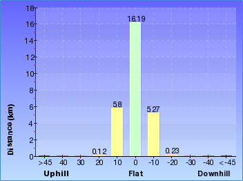
14 km of this walk has short steep hills and another 6km is flat with no steps. whilst another 6km has gentle hills with occasional steps and the remaining 1.6km is very step.
Quality of track
20km of this walk follows a clear and well formed tack or tie and another 4.5km follows a rough unclear track. the remaining (3.5km) follows a formed track with some branches and other obstacles.
Signs
21km of this walk is clearly signposted nd another 4.5km has no directional signs. the remamining (2.4km) has directional signs at most intersections.
Experience Required
10km of this walk requires no previous bush walking experience and another 9km requires some bush walking experience. the remaining (8km) requires a leader with a moderate level of bush walking Experience.
weather
Around 25km of this walk is affected by forecast, un forecast storms and server weather events that may impact on navigate and safety, wishlist the remaining 3km forecast un forecast storms and server weather likely to have an impact on your negative and safety.
Infrastructure
14km of this walk has limited facilities ( such as not all cliffs fenced ) and another 11 km is close to useful facilities ( such has fenced cliffs and seats ). whilst another 2.3km has no facilities provided and the remaining 790km limited facilities ( such cliffs no fenced, significant creeks not bridged).
Fire Danger
This walk passes Monaro Alpine fire area which currently has a None rating and No fire ban in place. (Downloaded 45 minutes ago)
This walk passes Southern Slopes fire area which currently has a None rating and No fire ban in place. (Downloaded 45 minutes ago)
Please Note: Each park may have its own fire ban, this rating is only valid for today and is based on information from the RFS Please
check the RFS Website for more information.
| °C (feels like °) | km/h from the - % humidity (as at ) |
| Fri ° | Mostly clear. |
| Sat -5° _ 10° | Mostly sunny. |
| Sun -4° _ 9° | Sunny. |
| Mon -4° _ 10° | Sunny. |
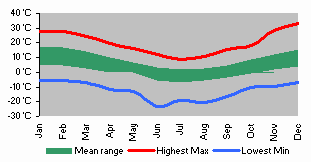
Weather and Climate summary
( detailed weather and climate information here)


Kosciuszko National Park:Link to official closures and fire bans page
Region: South Coast & Highlands Park fees Camping Facilities
Current Park Closure information for Kosciuszko National Park Closure information last downloaded Friday 15th of May 2015 10:00 PM
Island Bend campground partially closed due to maintenance - Island Bend campground (Ends Sunday 1 November)
Partial closure of Island Bend campground due to maintenance. Camp sites are now available at the lower camp at Island Bend in
Kosciuszko National Park. Some sites have been fenced and will remain closed for 6 to 12 months following capping works to ameliorate the asbestos risk and to allow for revegetation. Other sites have been gated or fenced and will remain closed due to ongoing asbestos risks. Please observe all signs and closures. For more information, please contact Andrew Miller at the NPWS Jindabyne Office on 0427 437 391 or visit the NSW National Parks safety page. Download a map of the closed areas.
Munyang Bridge closed (behind power station)
Snowy Hydro have advised that the Munyang Bridge behind the Guthega Power Station at Munyang will be closed to all traffic including pedestrians until further notice. As this bridge gives access to Disappointment Spur, this means that there is no access to Disappointment Spur from the Munyang end. Access is possible from the Whites River end but this requires then turning around and exiting the same way (via Whites River). Penalties apply for non-compliance. For more information, please contact the Project Manager for repairs Mark Kofler from Snowy Hydro on 0418 297255.
Strzelecki Creek Headwaters
Closure for campers at the Strzelecki Creek Headwaters close to the Sentinel. An infestation of Mouse-Ear Hawkweed (Pilosella officinarum) has been detected in the headwaters of Strzelecki Creek. National Parks and Wildlife Service are actively treating this weed as well as searching for other infestation in the area. The closed area is marked with signage, posts and fencing. We apologise for this inconvenience, and we are doing all we can to ensure this weed does not become established in this beautiful area. Penalties apply for non-compliance . For more information, please contact Area Manager, Alpine-Queanbeyan , Anthony Evans on [email protected] or visit the NSW National Parks safety page for park safety guidelines.
Thredbo Valley track from Ngarigo campground to The Diggings campground closed until midday Monday 18 May - Thredbo Valley track (Ends Monday 18 May)
Section 3 of the Thredbo Valley track from Ngarigo campground to The Diggings campground will be closed until Monday 18 May. Minor track reconstruction and maintenance has been carried out on the track near The Diggings campground and due to the recent rain and snow this work has become very wet and slippery and will need a couple of days to dry out before it is used. There are trees down over the track that will be cleared, during this closure. For more information, please phone Snowy Region Visitor Centre, Jindabyne on (02) 6450 5600 or visit the NSW National Parks safety page for park safety guidelines.

[recent-post]

[contact-form-7 id="165" title="Contact form 1"]


Comments