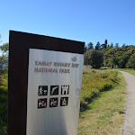
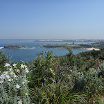
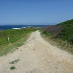
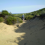
This short and easy walk to to the Quibray Bay viewing/lookout platform provides some lovely views and opportunities for bird watching. The platforms give you views across the heart of the very special Towra Point Nature Reserve. The nature reserve is very close to Sydney and most of it is closed to the public to protect the very fragile ecosystems and the resting area for migratory birds. This walk gives views that most Sydneysiders never see.
Quibray Bay viewing platform
And Walk
Quibray Bay viewing platform


10 mins
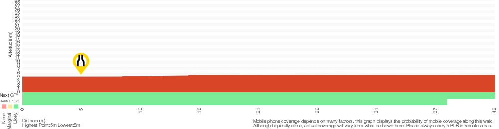
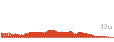
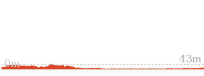
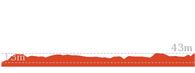
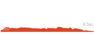
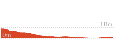
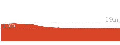
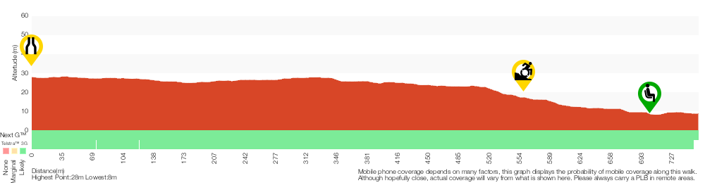
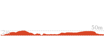
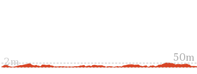
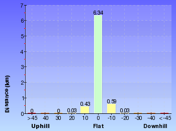
84 m Return

1 m
Very easy


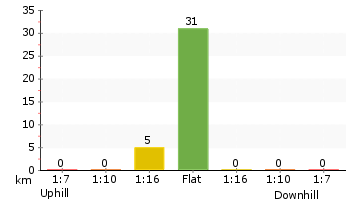
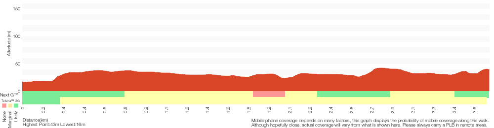
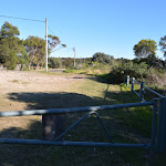
(0km) Captain Cook Dr → Quibray Bay Viewing Platform

40 m
1 mins
0m
-1m
Very easy
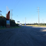
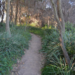
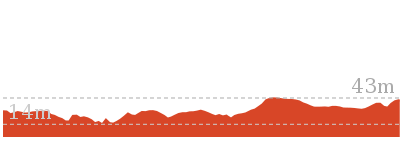
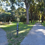
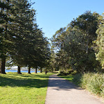
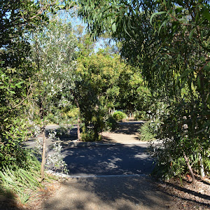
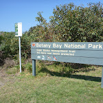
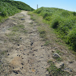
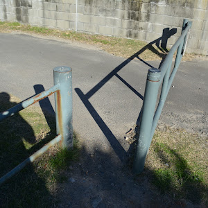
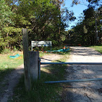
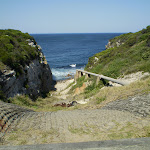
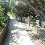
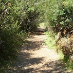
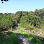
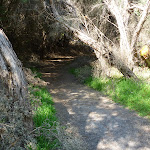
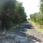
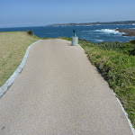
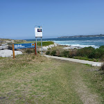
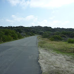
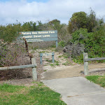
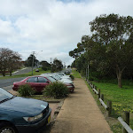
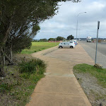
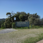
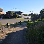
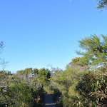
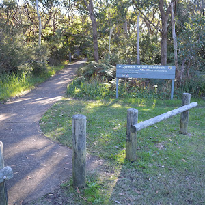
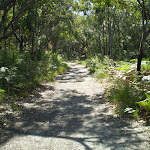
From the large gravel parking area beside Captin Cook Drive, Kurnell[1], this walk follows the footpath, between the timber bollards

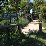
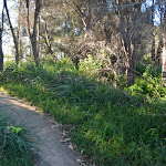
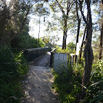
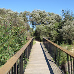
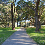
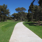
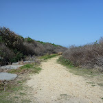
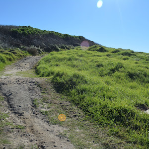
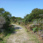
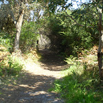
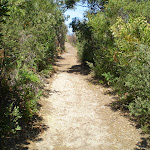
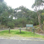
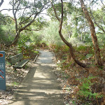
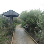
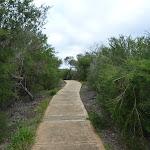
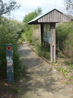
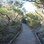
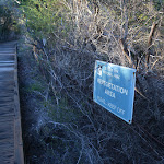
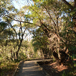
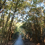
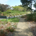
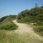
(1.3m gap) to follow the large ‘Towra Point Nature Reserve – Quibray Bay Viewing Platform’ sign[2] along the concrete path[3]. The walk follows the mostly flat concrete path for about 20m to then follow the timber boardwalk[4] (with handrails) for another 20m to the viewing platform[5][6][7].
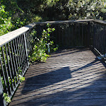
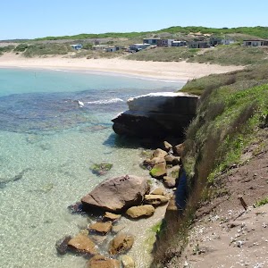
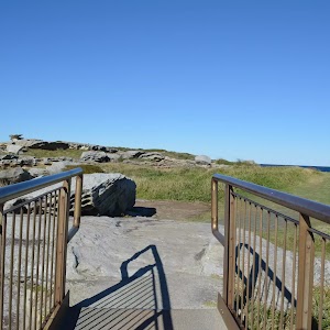
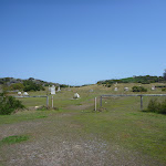
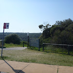
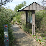
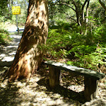
Quibray Bay Viewing Platform

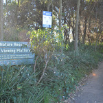
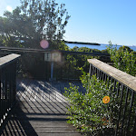
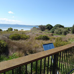
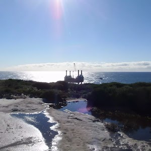
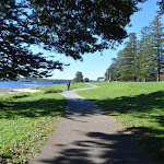
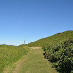
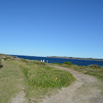
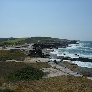
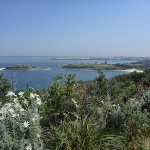
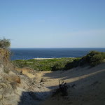
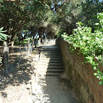
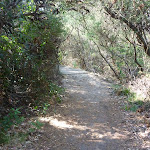
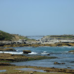
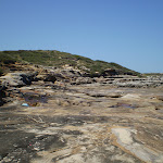
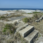
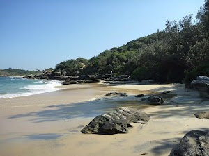
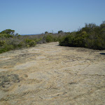
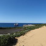
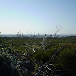
The Quibray Bay lookout platform is in the heart of the very special Towra Point Nature Reserve, Kurnell. There are magnificent views of the fragile coastline and wetlands. The nature reserve, very close to Sydney is protecting some very fragile ecosystems and is important resting area for migratory birds.
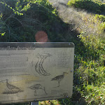
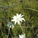
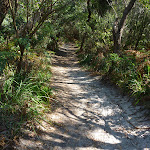
The lookout is nestled in a native acacia and banksia forest with open views[8] across the wetlands making it a perfect spot for bird watching. The platform is fenced (1m high), there are no seats but there are information signs about the local flora and fauna[9][10][11][12]. Please stay on the marked tracks[13].
The lookout is nestled in a native acacia and banksia forest with open views[8] across the wetlands making it a perfect spot for bird watching. The platform is fenced (1m high), there are no seats but there are information signs about the local flora and fauna[9][10][11][12]. Please stay on the marked tracks[13].
Maps for the Quibray Bay viewing platform walk
You can download the PDF for this walk to print a map.
These maps below cover the walk and the wider area around the walk, they are worth carrying for safety reasons.
| Port Hacking | 1:25 000 Map Series | 91294N PORT HACKING | NSW-91294N |
| Port Hacking | 1:100 000 Map Series | 9129 PORT HACKING | 9129 |
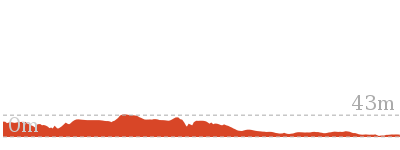
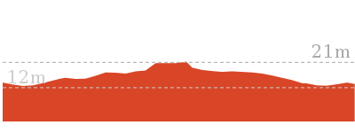
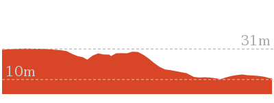
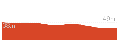
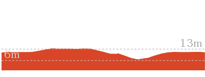
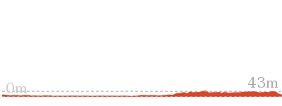
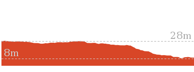
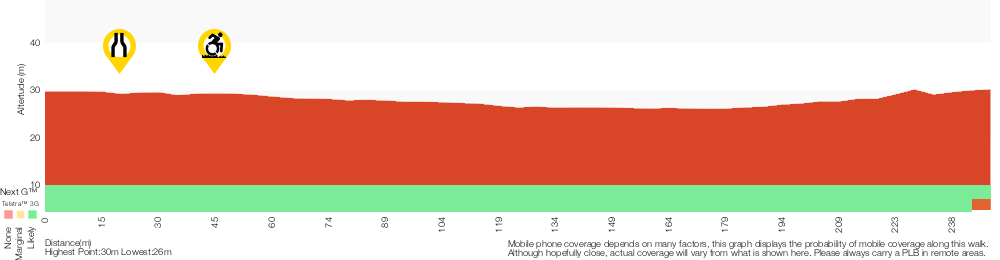
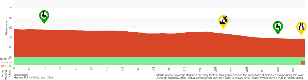
Cross sectional view of the Quibray Bay viewing platform bushwalking track
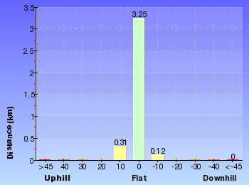
Analysis and summary of the altitude variation on the Quibray Bay viewing platform
Accessibility summary information for the Quibray Bay viewing platform
Parking: There are 0 designated accessible parking areas on this walk.
Toilets: There are 0 designated accessible toilets on this walk.
Seats: There are 0 places to sit on this walk.
Hazards: There are 0 specific noteable accessability related hazards on this walk.
Accessibility Details

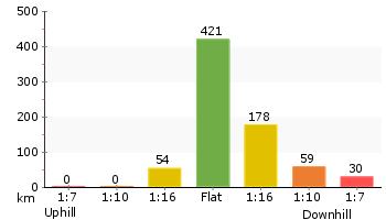
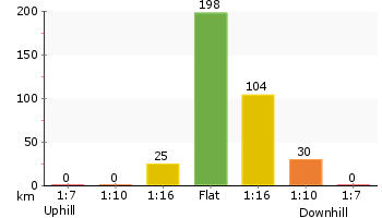
Overview of this walks grade – based on the AS 2156.1 – 2001
Under this standard, a walk is graded based on the most difficult section of the walk.
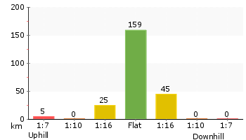
| Length | 84 m | ||
| Time | 10 mins | ||
| . | |||
| Grade 1/6 Very easy |
AS 2156.1 | Gradient | Flat, no steps (1/6) |
| Quality of track | Smooth and hardened path (1/6) | ||
| Signs | Clearly signposted (1/6) | ||
| Experience Required | No experience required (1/6) | ||
| Weather | Weather generally has little impact on safety (1/6) | ||
| Infrastructure | Generally useful facilities (such as fenced cliffs and seats) (1/6) |
Some more details of this walks Grading
Here is a bit more details explaining grading looking at sections of the walk
Gradient
This whole walk, 40m is flat with no steps.
Quality of track
This whole walk, 40m follows a smooth and hardened path.
Signs
This whole walk, 40m is clearly signposted.
Experience Required
This whole walk, 40m requires no previous bushwalking experience.
weather
This whole walk, 40m is not usually affected by severe weather events (that would unexpectedly impact safety and navigation).
Infrastructure
This whole walk, 40m is close to useful facilities (such as fenced cliffs and seats).
Similar walks
A list of walks that share part of the track with the Quibray Bay viewing platform walk.
Other Nearby walks
A list of walks that start near the Quibray Bay viewing platform walk.

5.5 km Return
2 hrs
Moderate track
5.4 km One way
2 hrs 30 mins
Hard track

3.8 km One way
1 hr 30 mins
Hard track
7.4 km Return
2 hrs 30 mins
Moderate track
12.7 km One way
4 hrs 15 mins
Hard track
5 km One way
1 hr 45 mins
Hard track
8.9 km Return
3 hrs
Moderate track
5.7 km One way
2 hrs 30 mins
Hard track
1.1 km One way
30 mins
Very easy
8.8 km Return
3 hrs
Moderate track
960 m Circuit
20 mins
Easy track

2.8 km Circuit
1 hr 30 mins
Moderate track
Plan your trip to and from the walk here
The Quibray Bay viewing platform walk starts and ends at the Captain Cook Dr (gps: -34.025, 151.18268)
Your transport options to Captain Cook Dr are by;
![]() Bus. (get details)
Bus. (get details)
![]() Car. There is free parking available.
Car. There is free parking available.
(get details)


Short URL = http://wild.tl/qbvp
Gallery images
There are other downloads I am still working on.
You will probably need to login to access these — still all free.
* KML (google earth file)
* GPX (GPS file)
Special Maps/ brochures
* A3 topo maps
* PDF with Lands Topo map base
* PDF with arial image (and map overlay)
I wanted to get the main site live first, this extra stuff will come in time.
Happy walking
Matt 🙂
Burrawang foreshore walk
And Walk
Burrawang foreshore walk

30 mins
1.1 km One way
10 m
Very easy
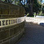
This pleasant stroll along a concrete footpath leads through a historically significant section of Kamay Botany Bay NP. Starting from the Visitor Centre, you take a short side trip to the Meeting Place where you will learn more about the Aboriginal people of the area. As the walk continues down to and along the waterfront you will pass the actual landing site for the Endeavour in 1770. You also pass a series of monuments to different men on the ship, including Captain Cook. There are also plenty of information signs to give further insight into the impacts of the Aboriginal people of the area. A lovely stroll with the chance to grab a snack at the end. This walk can be started at either end, you can allow extra time and return the same way if you prefer.

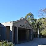


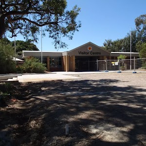
Visitor Centre
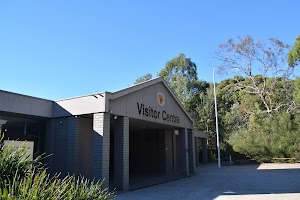
This visitors’ centre can be found on Cape Solander Drive, inside Kamay Botany Bay National Park. It provides great information about the area’s history and environment, plus there is a souvenir shop, where some simple food and drink is also available. A Trailrider is also available for free hire for people with limited mobility. There is a male & female toilet block

on the eastern side of the Visitor Centre. And a large parking area

in front.
(0km) Visitor Centre carpark → Meeting place int.
100 m
2 mins
0m
-2m
Very easy
From in front of the ‘Visitor Centre’[2], this walk follows the footpath ramp down[3] between the large metal ‘Welcome to Kamay Botany Bay National Park’[4] sign and the visitor centre building (keeping building to your right). After about 20m the path leads to a 3-way intersection marked with a large ‘National Heritage List – Kurnell Penisulla Headland’ sign[5], here the walk turns right and follows the concrete footpath through the open parkland for about 60m to come to a 3-way intersection[6] with a ‘Visitor Centre 100m’[7] arrow pointing back to the building.
(0.1km) Meeting place int. → The Meeting Place
40 m
1 mins
0m
0m
Very easy

The Meeting Place

This circular seating
[10] area provides an opportunity to reflect on the history of this land. A chance to consider the Aboriginal people, their connection to this land and that ‘At this place in April 1770 Aboriginal people gathered as a converted British coal ship, the Endeavour, appeared on the horizon and continued into the bay. As the landing party approached, two Aboriginal men advanced to the beach to challenge the group of strangers as they prepared to come ashore.’[11]
(0.1km) Meeting place int. → Solander Monument
230 m
4 mins
1m
-7m
Very easy
Continue straight: From the intersection, this walk follows the ‘Burrawang Walk’ wheelchair arrow[12], along the concrete footpath towards the distant water views and through the open parkland. After 50m this walk veers right at a 3-way intersection[13] (with a dirt driveway) and continues along the concrete path for another 180m to come beside the tall sandstone monolith monument to ‘Daniel Carl Solander’[14][15].
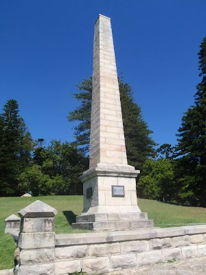
Solander Monument
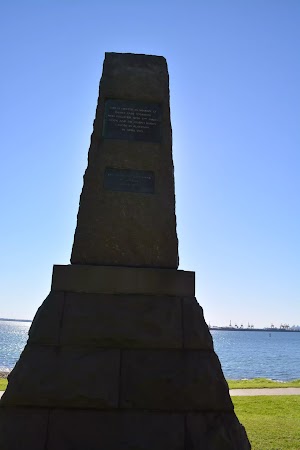
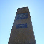
This monument was erected in memory of Daniel Carl Solander, who together with Cpt James Cook and Joseph Banks landed in Botany Bay in 1770.
(0.33km) Solander Monument → Wharf intersection
360 m
6 mins
6m
-2m
Very easy
Continue straight: From beside the ‘Daniel Carl Solander’ monument[16][17], this walk follows the conrete path downhill as it sweeps to the left for about 50m to come to the ‘Forry Sutherland’ memorial stone[18][19] (the first British subject to die in Australia), close to the water. Here the walk follows the footpath along the shorline for 120m to a large timber bridge[20] with information signs[21][22][23][24], seats[25]

, over a historically significant creek[26]. From the bridge this walk continues along the footpath for about 80m (beside the tall pine trees) to lead past the large round ‘Banks Monument’[27][28] (on the left) then about 100m later comes to a clear 4-way intersection with a wharf (on the right).
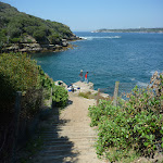
Kamay Wharf

Along the foreshore in Kamay Botany Bay National Park is this well-restored ferry wharf. Although not for use as a wharf today, it provides a wonderful fenced area to sit

, enjoy the view and learn more about the meeting of cultures[29][30][31][32] in view of where Captain Cook landed in 1770. Opposite the wharf is the historic Ferry Shelter

shed c1910.
(0.69km) Wharf Intersection → Captain Cook Monument
70 m
1 mins
0m
-3m
Very easy
Cook Monument
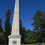
Cpt Cook landed in Botany Bay on the 28th of April in 1770. This monument was erected in 1870, and was unveiled by the honerable Thomas Holt, M.L.C, Victoria Regina, The Earl of Belmore, Governor.
(0.76km) Captain Cook Monument → Corner of Prince Charles parade and Captain Cook drive
300 m
5 mins
3m
-4m
Very easy
Continue straight: From the ‘Captain Cook’ monument[35], this walk follows the flat concrete footpath, keeping the water immediately to the right for 80m to come to a 3-way intersection marked with a ‘Burrang Walk’ arrow post.
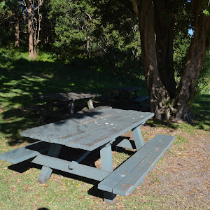
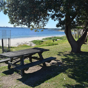
From the intersection, this walk heads along the flat concrete footpath, keeping the water immediately to the right for about 10m to pass a picnic table
From the intersection, this walk heads along the flat concrete footpath, keeping the water immediately to the right for about 10m to pass a picnic table

then continues alongside the beach for another 150m to find yet another picnic table

(under the tree on the left). Here the walk continues along the path past the ‘Kamay Botany Bay National Park’ sign[36] to find the car parks[37][38]

and picnic tables[39]

(opposite the shops[40] at the junction of Prince Charles Prd & Captain Cook Dr, Kurnell).
Endeavour Cafe and Ice Cream
Maps for the Burrawang foreshore walk walk
You can download the PDF for this walk to print a map.
These maps below cover the walk and the wider area around the walk, they are worth carrying for safety reasons.
| Port Hacking | 1:25 000 Map Series | 91294N PORT HACKING | NSW-91294N |
| Port Hacking | 1:100 000 Map Series | 9129 PORT HACKING | 9129 |
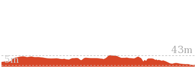
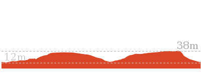
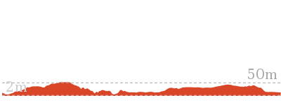
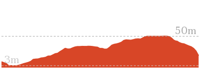
Cross sectional view of the Burrawang foreshore walk bushwalking track
Analysis and summary of the altitude variation on the Burrawang foreshore walk
Accessibility summary information for the Burrawang foreshore walk
Parking: There are 2 designated accessible parking areas on this walk.
They are 1060m apart.
They are 1060m apart.
Toilets: There are 0 designated accessible toilets on this walk.
Seats: There are 6 places to sit on this walk.
They are on average 210m apart, with a maximum gap of 510m.
Hazards: There are 0 specific noteable accessability related hazards on this walk.
Accessibility Details
Found 0m into this walk

Found 0m into this walk


Found 680m into this walk

Found 690m into this walk
Found 840m into this walk

Found 1010m into this walk

Found 1060m into this walk
Found 1060m into this walk
Overview of this walks grade – based on the AS 2156.1 – 2001
Under this standard, a walk is graded based on the most difficult section of the walk.
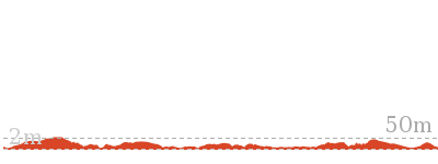
| Length | 1.1 km | ||
| Time | 30 mins | ||
| . | |||
| Grade 1/6 Very easy |
AS 2156.1 | Gradient | Flat, no steps (1/6) |
| Quality of track | Smooth and hardened path (1/6) | ||
| Signs | Clearly signposted (1/6) | ||
| Experience Required | No experience required (1/6) | ||
| Weather | Weather generally has little impact on safety (1/6) | ||
| Infrastructure | Generally useful facilities (such as fenced cliffs and seats) (1/6) |
Some more details of this walks Grading
Here is a bit more details explaining grading looking at sections of the walk
Gradient
This whole walk, 1.1km is flat with no steps.
Quality of track
This whole walk, 1.1km follows a smooth and hardened path.
Signs
This whole walk, 1.1km is clearly signposted.
Experience Required
This whole walk, 1.1km requires no previous bushwalking experience.
weather
This whole walk, 1.1km is not usually affected by severe weather events (that would unexpectedly impact safety and navigation).
Infrastructure
This whole walk, 1.1km is close to useful facilities (such as fenced cliffs and seats).
Similar walks
A list of walks that share part of the track with the Burrawang foreshore walk walk.
Other Nearby walks
A list of walks that start near the Burrawang foreshore walk walk.
8.8 km Return
3 hrs
Moderate track
960 m Circuit
20 mins
Easy track
2.8 km Circuit
1 hr 30 mins
Moderate track
8.9 km Return
3 hrs
Moderate track
5.7 km One way
2 hrs 30 mins
Hard track
7.4 km Return
2 hrs 30 mins
Moderate track
12.7 km One way
4 hrs 15 mins
Hard track
5 km One way
1 hr 45 mins
Hard track
5.5 km Return
2 hrs
Moderate track
5.4 km One way
2 hrs 30 mins
Hard track
3.8 km One way
1 hr 30 mins
Hard track
866 m Return
30 mins
Easy track
Plan your trip to and from the walk here
The Burrawang foreshore walk walk starts at the Visitor Centre carpark (gps: -34.005056, 151.22161)
Your main transport option to Visitor Centre carpark is by;
![]() Car. A park entry fee is required for driving into the park.
Car. A park entry fee is required for driving into the park.
(get details)
The Burrawang foreshore walk ends at the Corner of Prince Charles parade and Captain Cook drive (gps: -34.006693, 151.21575)
Your transport options to Corner of Prince Charles parade and Captain Cook drive are by;
![]() Bus. (get details)
Bus. (get details)
![]() Car. There is free parking available.
Car. There is free parking available.
(get details)
Short URL = http://wild.tl/bfw
Gallery images
There are other downloads I am still working on.
You will probably need to login to access these — still all free.
* KML (google earth file)
* GPX (GPS file)
Special Maps/ brochures
* A3 topo maps
* PDF with Lands Topo map base
* PDF with arial image (and map overlay)
I wanted to get the main site live first, this extra stuff will come in time.
Happy walking
Matt 🙂
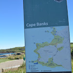
Cape Banks Island walk
And Walk
Cape Banks Island walk

45 mins
1.5 km Return
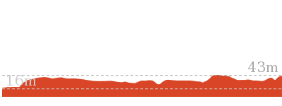
47 m
Hard track
On this walk, you will explore Cape Banks island surrounded by the aquaitic reserve and a beautiful coast line of Kamay Botany Bay NP. Starting from the end of Cape Banks Rd, you pass a historic gun emplacement, then explore the grassy coastline down to the water and edge of NSW Golf Course. There is a foot bridge to give access to the island and a novel T for the golf course. The island has a series of faint rough tracks that allow you to explore the bald island and views.


(0km) Southern End of Cape Banks Rd → Old toilet bock int.
40 m
1 mins
0m
-2m
Easy track
From the car park at the southern end of Cape Banks Rd, La Perouse[1], this walk follows a management trail, passing around a locked gate[2]

to then pass the ‘Botany Bay National Park’ sign[3] after about 10m. Then this walk continues to follow the asphalt trail beside the ‘Westpac Helicopter’ shed (on the right) for about 30m, to come to a 3-way intersection marked with an NPWS arrow post[4], just past a concrete building[5].
(0.04km) Old toilet bock int. → World War Two Bunker
60 m
1 mins
0m
-4m
Easy track
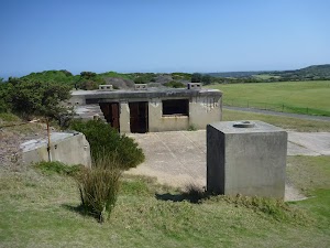
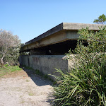
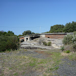
Continue straight: From the intersection, this walk follows the asphalt trail, keeping the large fence to the right[6] for about 40m to come to an intersection[7] just below the WW2 gun emplacement and bunker[8] (on the left). At the end of this side trip, retrace your steps back to the main walk then Turn right.
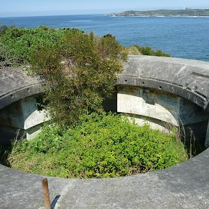
World War Two Bunker
(0.04km) Old toilet bock int. → Lifejacket intersection
280 m
6 mins
11m
-12m
Moderate track
Turn left: From the intersection, this walk follows the NPWS arrow[13] gently downhill along the gravel trail, directly away from the fence and helicopter shed[14]. The trail leads past the disused toilet buildings[15] then over a rise for 120m to find wide ocean views[16]. Here the trail bends right then undulates along the cliff line for 130m to come to a 3-way intersection marked with a life jacket signpost[17].
(0.32km) Lifejacket intersection → Cape Banks bridge int.
390 m
8 mins
4m
-18m
Hard track
Continue straight: From the intersection, this walk heads gently downhill along the grassy management trail keeping the ocean to the left[18]. After about 30m the trail descends steeply down a rough[19] 30m section

, then leads more gently downhill for 100m before leading down another very steep and rough section of trail[20] mostly flattening out near the apex of a large cleft in the sea cliff[21]. Here the trail continues more gently downhill for another 160m towards the golf course and ocean, passing a large rock platform[22] (on the left) coming to concrete footpath marked with two ‘Cape Banks Aquatic Reserve’ signs[23] just after the ‘Cape Bank’ map signpost[24]. Be mindful of golfers and golf balls.
(0.71km) Cape Banks bridge int. → Cape Banks
50 m
1 mins
0m
0m
Easy track
Turn left: From the ‘Cape Banks Aquatic Reserve’ sign[25], this walk follows the concrete footpath[26] gently downhill, away from the seat

, for about 20m to then cross over[27] to the island on the 20m long (1.1m wide) metal foot bridge[28]. Then this walk continues over the rocky track[29] to come beside the golf tee-off green[30] (on the right).
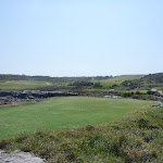
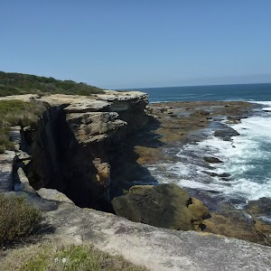
Cape Banks
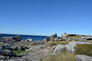
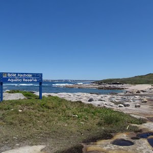
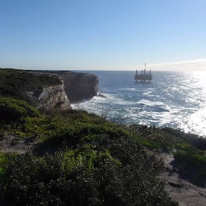
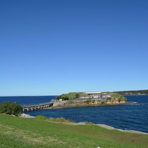
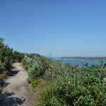
Cape Banks on the northern side of the entrance to Botany Bay, offers possibly the best view in Botany Bay National Park. From the unfenced cliff top, you can watch the power of the ocean as waves crash into the sandstone rock face below, or watch boats of all shapes and sizes, sail peacefully across the sheltered waters of the bay[31][32][33][34][35]. If you are lucky, you can enjoy the spectacle of migrating Humpback and Southern Right whales reasonably close to shore, spouting and sometimes breaching as they make their way northward and southward in pods of three or four. The shipwreck of the SS Minmi can be seen at low tide[37], lying on rocks on the western side of Cape Banks. There are concrete foundations of buildings remaining on Cape Banks, from when World War Two servicemen were stationed there.
Maps for the Cape Banks Island walk walk
You can download the PDF for this walk to print a map.
These maps below cover the walk and the wider area around the walk, they are worth carrying for safety reasons.
| Botany Bay | 1:25 000 Map Series | 91303S BOTANY BAY | NSW-91303S |
| Bondi | 1:25 000 Map Series | 91302S BONDI | NSW-91302S |
| Sydney | 1:100 000 Map Series | 9130 SYDNEY | 9130 |
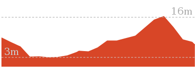
Cross sectional view of the Cape Banks Island walk bushwalking track
Analysis and summary of the altitude variation on the Cape Banks Island walk
Accessibility summary information for the Cape Banks Island walk
Parking: There are 0 designated accessible parking areas on this walk.
Toilets: There are 0 designated accessible toilets on this walk.
Seats: There are 1 places to sit on this walk.
Hazards: There are 0 specific noteable accessability related hazards on this walk.
Accessibility Details

Overview of this walks grade – based on the AS 2156.1 – 2001
Under this standard, a walk is graded based on the most difficult section of the walk.
| Length | 1.5 km | ||
| Time | 45 mins | ||
| . | |||
| Grade 4/6 Hard track |
AS 2156.1 | Gradient | Very steep (4/6) |
| Quality of track | Clear and well formed track or trail (2/6) | ||
| Signs | Directional signs along the way (3/6) | ||
| Experience Required | Some bushwalking experience recommended (3/6) | ||
| Weather | Weather generally has little impact on safety (1/6) | ||
| Infrastructure | Limited facilities, not all cliffs are fenced (3/6) |
Some more details of this walks Grading
Here is a bit more details explaining grading looking at sections of the walk
Gradient
390m of this walk is very steep and another 330m has gentle hills with occasional steps. The remaining (40m) is flat with no steps.
Quality of track
This whole walk, 760m follows a clear and well formed track or trail.
Signs
Around 670m of this walk has directional signs at most intersection, whilst the remaining 90m is clearly signposted.
Experience Required
Around 480m of this walk requires no previous bushwalking experience, whilst the remaining 280m requires some bushwalking experience.
weather
This whole walk, 760m is not usually affected by severe weather events (that would unexpectedly impact safety and navigation).
Infrastructure
Around 670m of this walk has limited facilities (such as not all cliffs fenced), whilst the remaining 90m is close to useful facilities (such as fenced cliffs and seats).
Similar walks
A list of walks that share part of the track with the Cape Banks Island walk walk.
1.9 km Return
1 hr 30 mins
Hard track
6.6 km Circuit
3 hrs
Hard track
6.8 km Circuit
3 hrs
Hard track
13 km One way
5 hrs
Hard track
13.4 km One way
5 hrs
Hard track
Other Nearby walks
A list of walks that start near the Cape Banks Island walk walk.
496 m Return
15 mins
Easy track
750 m Return
30 mins
Easy track
866 m Return
30 mins
Easy track
4.2 km Return
1 hr 30 mins
Moderate track
1.1 km Return
30 mins
Moderate track
792 m Circuit
30 mins
Easy track
8.8 km Return
3 hrs
Moderate track
960 m Circuit
20 mins
Easy track
2.8 km Circuit
1 hr 30 mins
Moderate track
1.1 km One way
30 mins
Very easy
8.9 km Return
3 hrs
Moderate track
5.7 km One way
2 hrs 30 mins
Hard track
Plan your trip to and from the walk here
The Cape Banks Island walk walk starts and ends at the Southern End of Cape Banks Rd (gps: -33.993462, 151.24974)
Your main transport option to Southern End of Cape Banks Rd is by;
![]() Car. There is free parking available.
Car. There is free parking available.
(get details)
Short URL = http://wild.tl/cbiw
Gallery images
There are other downloads I am still working on.
You will probably need to login to access these — still all free.
* KML (google earth file)
* GPX (GPS file)
Special Maps/ brochures
* A3 topo maps
* PDF with Lands Topo map base
* PDF with arial image (and map overlay)
I wanted to get the main site live first, this extra stuff will come in time.
Happy walking
Matt 🙂
Cape Bailey track
And Walk
Cape Baily track

2 hrs 30 mins
7.4 km Return
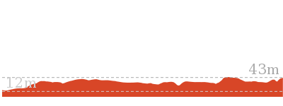
135 m
Moderate track
This great return walk follows the Cape Baily walking track as it winds along the coast, through thick heath and small sand dunes, to the Cape Baily lighthouse, with great ocean views all the way. Also of interest is the wide variety of flora and fauna that can be found on this walk, from a number of different types of reptiles and amphibians to the hanging swamps and wild flowers (in spring). There is even some good whale watching opportunities in June, July, Sept and Oct.


(0km) End of Polo Street → Int of Cape Bailey track and water tank service trail
400 m
8 mins
19m
-2m
Moderate track
From the end of the Polo St, this walk heads around the metal National Parks gate and south-east along the service trail, with some power lines on the right-hand side. As the track heads further south-east, the track steadily climbs up to the top of a gentle hill and continues along until it comes to the intersection of the Cape Bailey walk and the radar service trail.
(0.4km) Int of Cape Bailey track and water tank service trail → Tabbigai Gap Track Int
1.7 km
28 mins
16m
-26m
Moderate track
Turn left: From the intersection, this walk follows the service trail heading east (with the water tank on the right) for a very short distance until it comes to the intersection with a link bush track on the left.
Continue straight: From the intersection, the walk initially heads east, then turns right along the wide bush track, keeping the water tank and the radar on the right as it winds through the heath forest, coming to a four-way intersection with a wide management trail.
Veer left: From the intersection, the walk heads south (with the water tank directly behind) along the sandy bush track, and then along the rock-shelf until coming to an intersection marked by several arrows.
Turn right: From the intersection, this walk heads south (keeping the ocean to the left, about 150m away) along the rock and the sandy track, through the low dense scrub. Along this part of the track, there are several sections where wind and water erosion has developed small holes along the rock shelf that give it a very interesting look. After some time, this walk passes a small bush track on the left (which heads out to the coast), and shortly after this, comes to an intersection with a service trail at Tabbigai Gap.
(2.1km) Tabbigai Gap Track Int → Sand dune int
550 m
9 mins
8m
-6m
Moderate track
Veer left: From the Tabbigai Gap, this walk follows the clear, sandy track east (with the Tabbigai Gap on the left) up a short hill until it turns right at the small clearing. The track stays away from the ocean and soon comes to a large sand dune clearing. From the other end of the clearing, the walk follows the track south (ocean on the left) through the thick scrub, winding along until it rises up a hill to a long sand dune clearing. From the far end of this clearing, the walk follows the overgrown track through the thick scrub, until it widens out a little and continues south for a short distance, to the intersection in the pit of a sand dune, with a large hanging swamp on the right.
Hanging Swamps

There are a number of hanging swamps that can be found along the Cape Baily walk. They are home to a number of different plants and animals like reeds and frogs. Hanging swamps are formed on high ground when rainfall seeps out of surrounding hills and accumulates in a slight depression, over time forming a swamp. Interestingly, they are sometimes difficult to see from far away as the thick build up of reeds and other plant life often cover the water.
(2.65km) Sand dune int → Int of Cape Baily lighthouse track
950 m
18 mins
28m
-22m
Moderate track
Turn right: From the intersection, this walk follows the narrow bush track that heads west to the top of the dunes. (From the top of the dune there are some great views of the hanging swamp straight ahead). The track then turns left and drops off the top of the sand dune, keeping the swamp on the right. The track then climbs a sandy hill to some more views before turning left and heading along a sandy track, through several more large sand dunes. After these dunes, the track starts to flatten out and widen, to head along to an intersection with a bush track (which heads to the lighthouse).
(3.6km) Int of Cape Baily Lighthouse track → Cape Baily Lighthouse
80 m
2 mins
8m
0m
Moderate track
Veer right: From the intersection, this walk follows the sandy bush track, heading up and away from the ocean. The track is relatively defined for most of the way, however in the last 20m the track becomes quite overgrown and a little less defined (the lighthouse is always visible). Once at the lighthouse, there are good views inland, however the views to the east are largely blocked by the high scrub.
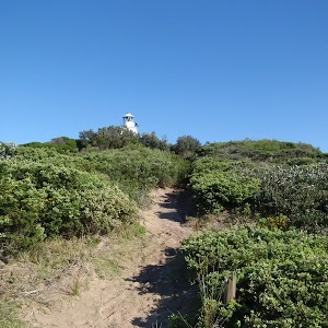
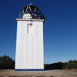
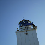
Cape Baily Lighthouse
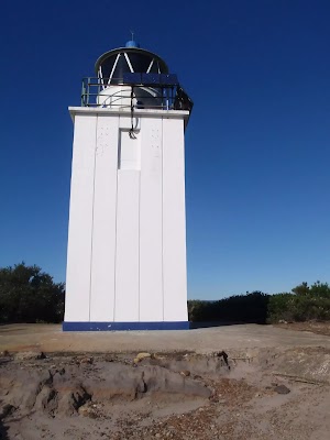
Established in 1950, the lighthouse was required so north-bound shipping could hug the coast and avoid the strong southerly currents further out to sea. This lighthouse can be found a stone’s-throw from the Cape Baily coastal walk, about 1.5 kilometres north from the Joseph Banks Drive car park. More info.
Maps for the Cape Baily track walk
You can download the PDF for this walk to print a map.
These maps below cover the walk and the wider area around the walk, they are worth carrying for safety reasons.
| Port Hacking | 1:25 000 Map Series | 91294N PORT HACKING | NSW-91294N |
| Port Hacking | 1:100 000 Map Series | 9129 PORT HACKING | 9129 |
Cross sectional view of the Cape Baily track bushwalking track
Analysis and summary of the altitude variation on the Cape Baily track
Overview of this walks grade – based on the AS 2156.1 – 2001
Under this standard, a walk is graded based on the most difficult section of the walk.
| Length | 7.4 km | ||
| Time | 2 hrs 30 mins | ||
| . | |||
| Grade 3/6 Moderate track |
AS 2156.1 | Gradient | Short steep hills (3/6) |
| Quality of track | Formed track, with some branches and other obstacles (3/6) | ||
| Signs | Directional signs along the way (3/6) | ||
| Experience Required | Some bushwalking experience recommended (3/6) | ||
| Weather | Weather generally has little impact on safety (1/6) | ||
| Infrastructure | Limited facilities, not all cliffs are fenced (3/6) |
Some more details of this walks Grading
Here is a bit more details explaining grading looking at sections of the walk
Gradient
Around 2km of this walk has short steep hills, whilst the remaining 1.6km has gentle hills with occasional steps.
Quality of track
Around 2.6km of this walk follows a formed track, with some branches and other obstacles, whilst the remaining 1.1km follows a clear and well formed track or trail.
Signs
This whole walk, 3.7km has directional signs at most intersection.
Experience Required
Around 2.5km of this walk requires no previous bushwalking experience, whilst the remaining 1.2km requires some bushwalking experience.
weather
This whole walk, 3.7km is not usually affected by severe weather events (that would unexpectedly impact safety and navigation).
Infrastructure
Around 3.3km of this walk has limited facilities (such as not all cliffs fenced), whilst the remaining 420m is close to useful facilities (such as fenced cliffs and seats).
Similar walks
A list of walks that share part of the track with the Cape Baily track walk.
3.8 km One way
1 hr 30 mins
Hard track
5 km One way
1 hr 45 mins
Hard track
5.4 km One way
2 hrs 30 mins
Hard track
5.5 km Return
2 hrs
Moderate track
5.7 km One way
2 hrs 30 mins
Hard track
8.8 km Return
3 hrs
Moderate track
8.9 km Return
3 hrs
Moderate track
12.7 km One way
4 hrs 15 mins
Hard track
13.1 km One way
4 hrs 30 mins
Hard track
Other Nearby walks
A list of walks that start near the Cape Baily track walk.
960 m Circuit
20 mins
Easy track
2.8 km Circuit
1 hr 30 mins
Moderate track
1.1 km One way
30 mins
Very easy
866 m Return
30 mins
Easy track
4.2 km Return
1 hr 30 mins
Moderate track
13 km One way
5 hrs
Hard track
6.6 km Circuit
3 hrs
Hard track
6.8 km Circuit
3 hrs
Hard track
1.1 km Return
30 mins
Moderate track
792 m Circuit
30 mins
Easy track
1.5 km Return
45 mins
Hard track
496 m Return
15 mins
Easy track
Plan your trip to and from the walk here
The Cape Baily track walk starts and ends at the End of Polo Street (gps: -34.010521, 151.22277)
Your transport options to End of Polo Street are by;
![]() Bus. (get details)
Bus. (get details)
![]() Car. There is free parking available.
Car. There is free parking available.
(get details)
Short URL = http://wild.tl/cbt
Gallery images
There are other downloads I am still working on.
You will probably need to login to access these — still all free.
* KML (google earth file)
* GPX (GPS file)
Special Maps/ brochures
* A3 topo maps
* PDF with Lands Topo map base
* PDF with arial image (and map overlay)
I wanted to get the main site live first, this extra stuff will come in time.
Happy walking
Matt 🙂
The Coastal Hospital Cemetery Walk
And Walk
The Coastal Hospital Cemetery Walk

15 mins
496 m Return
8 m
Easy track
The Coastal Hospital Cemetery Walk is an easy walk, near a beautiful coastline, visiting an early Australian cemetery. The cemetery is located on raised ground, with views out to the coast and sea. Used primarily as a cemetery for the old quarantine hospital from the 1880’s, it is home to over 2000 graves (most not visible). The visible grave sites are interesting and provide a fascinating glimpse into life (and death) 100 years ago. Worth a visit if you are in the area or if you have an interest in the local history.


(0km) Int of Cape Banks Rd & Cemetery Trail → Coast Hospital Cemetery int.
150 m
2 mins
0m
-5m
Easy track
From the ‘Cemetry Trail’ trackhead and dirt car park[1] on Cape Banks Rd
La Perouse (about 1km past NSW Golf Course main gate), this walk follows the ‘Cemetry Trail’ sign[2] around the locked gate[3][4][5]
La Perouse (about 1km past NSW Golf Course main gate), this walk follows the ‘Cemetry Trail’ sign[2] around the locked gate[3][4][5]

, and along the management trail. The grassy trail leads for about 20m to pass over a cobbeled stone section[6]

then continues to follow the level trail[7] for another 110m, to come to a large 3-way intersection[8] near the Coastal Cemetery[9] (on the right).
(0.15km) Coast Hospital Cemetery int. → Coast Hospital Cemetery
100 m
2 mins
3m
0m
Easy track
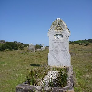
Veer right: From the intersection, this walk heads away from the main trail and into the large clearing[10] towards the timber fences[11] and entrance to the cemetery. The walk veers right following the NPWS arrow [12] through the gap in the fence and into the grassy cemetery[13]. From here you can roam around exploring and reading the head stones.
Coast Hospital Cemetery
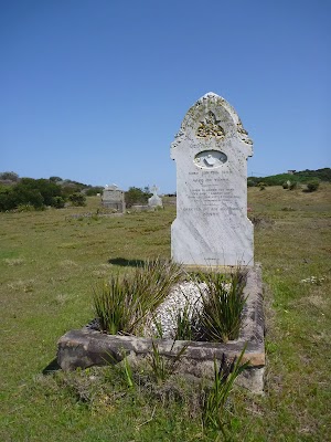
The Coast Hospital Cemetery on the northern side of Botany Bay was first established in the early 1880’s and is now home to as many as 2000 graves. It serviced the Coast (Prince Henry) Hospital, originally a smallpox hospital. People who died of smallpox were required to be buried at the hospital grounds. The hospital was built far enough from the city to provide quarantine and for this reason, the hospital in time became an infectious diseases hospital, also treating patients with influenza, bubonic plague, typhoid fever and leprosy. Unfortunately, the cemetery has at times fallen into disrepair and some of the headstones are difficult to read. Many of the graves are unmarked.
On the eastern edge of the cemetery is an information sign[15] explaining that in the area are also buried the ancestral remains of the La Perouse Aboriginal people returned from museums.
A place steeped in history and worthy of respect.
On the eastern edge of the cemetery is an information sign[15] explaining that in the area are also buried the ancestral remains of the La Perouse Aboriginal people returned from museums.
A place steeped in history and worthy of respect.
Maps for the The Coastal Hospital Cemetery Walk walk
You can download the PDF for this walk to print a map.
These maps below cover the walk and the wider area around the walk, they are worth carrying for safety reasons.
| Botany Bay | 1:25 000 Map Series | 91303S BOTANY BAY | NSW-91303S |
| Bondi | 1:25 000 Map Series | 91302S BONDI | NSW-91302S |
| Sydney | 1:100 000 Map Series | 9130 SYDNEY | 9130 |
Cross sectional view of the The Coastal Hospital Cemetery Walk bushwalking track
Analysis and summary of the altitude variation on the The Coastal Hospital Cemetery Walk
Accessibility summary information for the The Coastal Hospital Cemetery Walk
Parking: There are 0 designated accessible parking areas on this walk.
Toilets: There are 0 designated accessible toilets on this walk.
Seats: There are 0 places to sit on this walk.
Hazards: There are 1 specific noteable accessability related hazards on this walk.
Wheelchair Rough A 20m section of the trail has exposed sandstone cobbles. Found about 40m into the walk.
Accessibility Details


Overview of this walks grade – based on the AS 2156.1 – 2001
Under this standard, a walk is graded based on the most difficult section of the walk.
| Length | 496 m | ||
| Time | 15 mins | ||
| . | |||
| Grade 2/6 Easy track |
AS 2156.1 | Gradient | Gentle hills with occasional steps (2/6) |
| Quality of track | Clear and well formed track or trail (2/6) | ||
| Signs | Clearly signposted (1/6) | ||
| Experience Required | No experience required (1/6) | ||
| Weather | Weather generally has little impact on safety (1/6) | ||
| Infrastructure | Generally useful facilities (such as fenced cliffs and seats) (1/6) |
Some more details of this walks Grading
Here is a bit more details explaining grading looking at sections of the walk
Gradient
This whole walk, 250m has gentle hills with occasional steps.
Quality of track
Around 150m of this walk follows a clear and well formed track or trail, whilst the remaining 100m follows a smooth and hardened path.
Signs
This whole walk, 250m is clearly signposted.
Experience Required
This whole walk, 250m requires no previous bushwalking experience.
weather
This whole walk, 250m is not usually affected by severe weather events (that would unexpectedly impact safety and navigation).
Infrastructure
This whole walk, 250m is close to useful facilities (such as fenced cliffs and seats).
Similar walks
A list of walks that share part of the track with the The Coastal Hospital Cemetery Walk walk.
1.9 km Return
1 hr 30 mins
Hard track
6.6 km Circuit
3 hrs
Hard track
6.8 km Circuit
3 hrs
Hard track
13 km One way
5 hrs
Hard track
13.4 km One way
5 hrs
Hard track
Other Nearby walks
A list of walks that start near the The Coastal Hospital Cemetery Walk walk.
1.5 km Return
45 mins
Hard track
750 m Return
30 mins
Easy track
866 m Return
30 mins
Easy track
4.2 km Return
1 hr 30 mins
Moderate track
1.1 km Return
30 mins
Moderate track
792 m Circuit
30 mins
Easy track
8.8 km Return
3 hrs
Moderate track
960 m Circuit
20 mins
Easy track
2.8 km Circuit
1 hr 30 mins
Moderate track
1.1 km One way
30 mins
Very easy
8.9 km Return
3 hrs
Moderate track
5.7 km One way
2 hrs 30 mins
Hard track
Plan your trip to and from the walk here
The The Coastal Hospital Cemetery Walk walk starts and ends at the Int of Cape Banks Rd & Cemetery Trail (gps: -33.990814, 151.24856)
Your main transport option to Int of Cape Banks Rd & Cemetery Trail is by;
![]() Car. There is free parking available.
Car. There is free parking available.
(get details)
Short URL = http://wild.tl/tchcw
Gallery images
There are other downloads I am still working on.
You will probably need to login to access these — still all free.
* KML (google earth file)
* GPX (GPS file)
Special Maps/ brochures
* A3 topo maps
* PDF with Lands Topo map base
* PDF with arial image (and map overlay)
I wanted to get the main site live first, this extra stuff will come in time.
Happy walking
Matt 🙂
Henry Head Circuit
And Walk
Henry Head Circuit

3 hrs
6.8 km Circuit
174 m
Hard track
This walk has a lovely mix of natural and war history combined within the scenic Botany Bay National Park. The track follows beaches and cliff tops as it visits World War One and Two gun and lookout stations. The side trip to the coastal cemetery is worthwhile, giving a glimpse into lives from the past. The Jennifer Street section of this circuit allows access through a section of endangered native Banksia scrub that once occupied a much larger part of the Sydney region. A varied and interesting day out in the Botany Bay National Park.


(0km) Southern End of Cann Park → Eastern end of Congwong Beach
230 m
4 mins
2m
-8m
Moderate track
From the southern end of Cann Park[1], this walk follows the concrete track down a series of stairs[2], passing the ‘Congwong Beach Walk’ sign[3] on your right. This walk continues gently downhill on a sandy track for about 40m, to find the western end of Congwong Beach[4]. Then this walk follows the beach, with the water to your right, for about 140m until coming to a three-way intersection, with the ‘Henry Head/Little Congwong Beach’ sign[5].
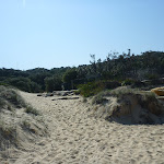
(0.23km) Eastern end of Congwong Beach → Little Congwong Beach
310 m
6 mins
13m
-11m
Moderate track
Turn right: From the eastern end of Congwong Beach[6], this walk follows a mostly level concrete track, passing a ‘Little Congwong Beach Track’ sign[7] (on the left) and keeping the water on the right for about 230m (with coastal views on the right[8]). Then this walk follows a sandy track moderately steeply downhill[9], with occasional timber steps[10] for about 90m, until coming to the western end of Little Congwong Beach[11]. At the end of this side trip, retrace your steps back to the main walk then Turn right.
Little Congwong Beach
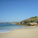
Little Congwong Beach, located at La Perouse, is a sheltered sandy beach[12] that has been described as one of the most beautiful beach oases in Sydney. Little Congwong beach has also been used for over 40 years as an unofficial and secluded nude beach. If you see any offensive behaviour please call Crime Stoppers on 1800 333000 or the Maroubra Police on 02 9349 9299. This beach is very popular on summer weekends and has limited shade in the afternoon. More info.
(0.23km) Eastern end of Congwong Beach → Int of Henry Head Track and Congwong Beach Servicetrail
210 m
4 mins
10m
0m
Moderate track
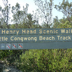
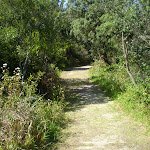
Continue straight: From the intersection[15], this walk follows the ‘Henry Head Scenic Walk’ sign[16] and wide track gently uphill and away from the beach through coastal bush. The walk continues to follow the timber and concrete track [17] moderately steeply uphill[18] for about 160m, until coming to a three-way intersection[19] with a track on the right.
(0.44km) Int of Henry Head Track and Congwong Beach Servicetrail → Int of Henry Head Track & Henry Head Lane Track
260 m
6 mins
18m
-3m
Moderate track
(0.69km) Int of Henry Head Track and Henry Head Lane Track → Int of Henry Head Track AND Depot Trail
240 m
4 mins
6m
-2m
Moderate track
Veer right: From the intersection[24], this walk follows the ‘Henry Head’ sign east along a wide track, gently uphill through wooded forest[25]. This walk continues to follow the track for about 170m, until coming to a three-way intersection[26], with a narrow management trail and large green shed[27] (on the left).
(0.93km) Int of Henry Head Track AND Depot Trail → Int of Henry Head and Browns Rock Tracks
400 m
8 mins
17m
-7m
Moderate track
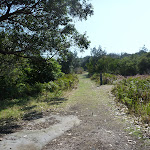
Continue straight: From the intersection[28], this walk follows the track gently downhill[29] for about 20m to come to a shallow, dry water course[30]. Then this walk continues to follow the track gently uphill through moist forest[31] for about 120m, coming to a metal ring fence[32] (on the right). The walk follows the track moderately steeply uphill[33] with occasional timber steps for about 260m, until coming to a four-way intersection[34]. This intersection has a track to the left[35], a ‘Henry Head’ signed[36] track tending right and a ‘Browns Rock’ signed[37] track to the right.
(1.33km) Int of Henry Head and Browns Rock Tracks → Browns Rock
310 m
7 mins
0m
-38m
Hard track
Turn sharp right: From the intersection[38], this walk follows the track gently downhill, following the ‘Browns Rock 280m’ sign[39]. About 110m down the track, the walk continues down a moderately steep hill with timber steps[40] for a further 180m, until coming to a square concrete platform[41] on the water and Browns Rock. At the end of this side trip, retrace your steps back to the main walk then Turn sharp right.
Browns Rock
Browns Rock is a popular fishing spot at La Perouse, with an unfenced shelf of rock and concrete from which to cast fishing rods[42]. Unfortunately, this area suffers from littering[44] – Please help by carrying out your own rubbish and a few extra bits where safe (the rangers do a great job, but it is hard to keep up). More info.
(1.33km) Int of Henry Head and Browns Rock Tracks → Int of Henry Head Track & Golf Course Management Trail
220 m
4 mins
7m
-2m
Moderate track
Turn right: From the intersection[45], this walk follows the wide sandy track gently uphill, past the ‘Henry Head 700m’ sign[46] (on the left). After about 70m, the walk passes views of Bare Island[47] on the right, then continues to follow the track moderately steeply uphill through low coastal forest for about 140m, until coming to a T-intersection[48] with a management trail.
(1.55km) Int of Henry Head Track and Golf Course Management Trail → Int of Henry Head Track and Henry Head Trail
310 m
5 mins
0m
-8m
Moderate track
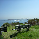
Turn right: From the intersection[49], this walk follows the wide level track south, passing the bench seat (on the right). Then this walk continues to follow the track through dense coastal bush for about 70m, until finding a World War One fort[50] (on the right). This walk continues to follow a sandy, moderately steep downhill track for about 130m, where there are views of Bare Island[51] on the right. This walk then continues to follow the track through dense forest[52] for about 100m, until passing between timber posts[53] and coming to a T-intersection, with a management trail.
(1.86km) Int of Henry Head Track and Henry Head Trail → Henry Head
230 m
5 mins
0m
-23m
Easy track
Henry Head
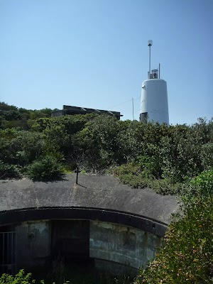
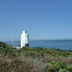
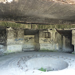
The Henry Head Battery is located on the northern side of the entrance to Botany Bay at Henry Head. The battery was constructed on an unfenced headland between 1892 and 1895 and operated until 1910 when it was closed down. The battery and observation posts was re-utilised during World War Two to defend against approaches to Botany Bay. The battery consisted of two disappearing guns, ammunition storage and observation posts. The underground bunker and tunnel complex consisted of vaulted ammunition storage rooms with double walls and ceilings. The doubling-up of walls and ceilings was a preventative measure meant to stop the walls from collapsing in the event of a direct hit. The battery is currently not in use. The white tower on the battery is the Endeavour Tower, not a lighthouse as such, but a red marker light nonetheless. More info.
(2.09km) Henry Head → Cruwee Cove
840 m
20 mins
42m
-59m
Hard track
Turn sharp left: From the white round tower[61] at Henry Head, this walk follows the track east over rock slabs[62], with the water to the right. After about 130m, the walk then follows a narrow rocky track[63] through coastal heath for about 130m, then descends rock steps[64] to exposed rock platforms[65] (with views back to Henry Head and the south coast[66]). Then this walk continues along the narrow track, gently undulating through coastal forest[67] for about 600m, until coming to Cruwee Cove[68] and Shelly Beach[69].
(2.93km) Cruwee Cove → North end of Cape Banks Bridge
470 m
10 mins
23m
-14m
Hard track
Turn left: From Cruwee Cove[70], this walk follows the beach east, with the water on your right. At the end of the beach, the walk follows initially level rock shelves, then moderately steep uphill rock shelves onto a grassy track[71], and comes to a golf course[72] after about 90m. Then this walk follows a sealed footpath across the golf course for about 250m, until coming to the ‘Cape Banks Aquatic Reserve’ sign[73] and Cape Banks bridge[74].
(3.39km) Cape Banks bridge int. → Cape Banks
50 m
1 mins
0m
0m
Easy track
Veer right: From the ‘Cape Banks Aquatic Reserve’ sign[75], this walk follows the concrete footpath[76] gently downhill, away from the seat
, for about 20m to then cross over[77] to the island on the 20m long (1.1m wide) metal foot bridge[78]. Then this walk continues over the rocky track[79] to come beside the golf tee-off green[80] (on the right).
(3.44km) Cape Banks → Cape Banks bridge int.
50 m
1 mins
0m
0m
Easy track
Turn around: From the golf tee-off green[81] on the northern edge of Cape Banks headland, this walk follows a rocky track[82] to the bridge. The walk now crosses over[83] to the mainland on the 20m long (1.1m wide) metal foot bridge[84], where the walk leads gently uphill along the concrete footpath to the intersection marked with a ‘Cape Banks Aquatic Reserve’ sign[85], just before a seat
.
(3.5km) Cape Banks bridge int. → Cape Banks
50 m
1 mins
0m
0m
Easy track
Turn around: From the ‘Cape Banks Aquatic Reserve’ sign[86], this walk follows the concrete footpath[87] gently downhill, away from the seat
, for about 20m to then cross over[88] to the island on the 20m long (1.1m wide) metal foot bridge[89]. Then this walk continues over the rocky track[90] to come beside the golf tee-off green[91] (on the right). At the end of this side trip, retrace your steps back to the main walk then Turn right.
Cape Banks
Cape Banks on the northern side of the entrance to Botany Bay, offers possibly the best view in Botany Bay National Park. From the unfenced cliff top, you can watch the power of the ocean as waves crash into the sandstone rock face below, or watch boats of all shapes and sizes, sail peacefully across the sheltered waters of the bay[92][93][94][95][96]. If you are lucky, you can enjoy the spectacle of migrating Humpback and Southern Right whales reasonably close to shore, spouting and sometimes breaching as they make their way northward and southward in pods of three or four. The shipwreck of the SS Minmi can be seen at low tide[98], lying on rocks on the western side of Cape Banks. There are concrete foundations of buildings remaining on Cape Banks, from when World War Two servicemen were stationed there.
(3.5km) Cape Banks bridge int. → Lifejacket intersection
390 m
8 mins
18m
-4m
Hard track
Turn right: From the ‘Cape Banks Aquatic Reserve’ sign[99], this walk follows the gravel then grassy trail [100] away from the ocean for about 10m to find a ‘Cape Bank’ map signpost[101]. From the sign, this walk follows the ‘Coastal Walk’ arrow[102] gently uphill along the grassy trail (passing a large rock platform[103] on the right) for about 160m to near the apex of a large cleft in the sea cliff[104] (on the right). From here the walk climbs very steeply up a rough[105] trail for about 30m
, then leads more gently uphill for 100m before leading up another steep and rough section of trail[106]. The walk then continues more gently uphill along the grassy management trail for another 30m to come to a 3-way intersection marked with a ‘life jacket’ signpost[107].
(3.88km) Int of Cape Banks Management & Pistol Club Trail → World War Two Bunker
110 m
2 mins
2m
-4m
Moderate track
Veer left: From the intersection[108], this walk follows the wide management trail steeply uphill[109], away from the water. This walk continues to follow the level trail for about 35m to a T-intersection[110], where the walk turns right and follows a trail (with a metal ring fence[111] on the left) for about 20m to a World War Two Bunker[112] (on the right).
World War Two Bunker
(3.99km) World War Two Bunker → Southern End of Cape Banks Rd
100 m
2 mins
6m
0m
Easy track
Turn left: From the intersection (just below the WW2 gun emplacement and bunker[117]), this walk follows the asphalt trail along the fenceline towards the ‘Westpac Helicopter’ shed[118] for just shy of 40m to find a 3-way intersection[119] before a concrete building[120], marked with an NPWS arrow[121].
Continue straight: From the intersection, this walk follows the main asphalt trail keeping the metal ring fence on the left for about 30m to head around the locked gate[122]
Continue straight: From the intersection, this walk follows the main asphalt trail keeping the metal ring fence on the left for about 30m to head around the locked gate[122]
and find the car park at the southern end of Cape Banks Rd, La Perouse[123].
(4.09km) Southern End of Pistol Club Rd → Int of Pistol Club Rd AND Coastal Cemetery Management Trail
320 m
5 mins
2m
-1m
Easy track
Continue straight: From the southern end of Pistol Club Rd[124], this walk follows the road gently uphill away from the ‘Westpac Helicopter’ sign and shed, passing a sealed car park (on the left). This walk continues to follow the road, with views (on the right) of the coastal cemetery[125] after about 200m. This walk then continues to follow the road gently downhill for about 140m, until coming to a three-way intersection, with an unsealed car park[126] and ‘Coastal Cemetery’ sign[127] (on the right).
(4.41km) Int of Cape Banks Rd & Cemetery Trail → Coast Hospital Cemetery int.
150 m
2 mins
0m
-5m
Easy track
Turn right: From the ‘Cemetry Trail’ trackhead and dirt car park[128] on Cape Banks Rd
La Perouse (about 1km past NSW Golf Course main gate), this walk follows the ‘Cemetry Trail’ sign[129] around the locked gate[130][131][132]
La Perouse (about 1km past NSW Golf Course main gate), this walk follows the ‘Cemetry Trail’ sign[129] around the locked gate[130][131][132]
, and along the management trail. The grassy trail leads for about 20m to pass over a cobbeled stone section[133]
then continues to follow the level trail[134] for another 110m, to come to a large 3-way intersection[135] near the Coastal Cemetery[136] (on the right). At the end of this side trip, retrace your steps back to the main walk then Turn right.
Coast Hospital Cemetery
The Coast Hospital Cemetery on the northern side of Botany Bay was first established in the early 1880’s and is now home to as many as 2000 graves. It serviced the Coast (Prince Henry) Hospital, originally a smallpox hospital. People who died of smallpox were required to be buried at the hospital grounds. The hospital was built far enough from the city to provide quarantine and for this reason, the hospital in time became an infectious diseases hospital, also treating patients with influenza, bubonic plague, typhoid fever and leprosy. Unfortunately, the cemetery has at times fallen into disrepair and some of the headstones are difficult to read. Many of the graves are unmarked.
On the eastern edge of the cemetery is an information sign[138] explaining that in the area are also buried the ancestral remains of the La Perouse Aboriginal people returned from museums.
A place steeped in history and worthy of respect.
On the eastern edge of the cemetery is an information sign[138] explaining that in the area are also buried the ancestral remains of the La Perouse Aboriginal people returned from museums.
A place steeped in history and worthy of respect.
(4.41km) Int of Pistol Club Rd and Coast Hospital Cemetery Management Trail → Int of Pistol Club Rd AND Jennifer Street Boardwalk Track
760 m
13 mins
12m
-3m
Easy track
Continue straight: From the intersection[139], this walk follows the level road west[140], with golf courses on the left and right (ignoring side roads[141]) for about 800m, until coming to a gentle uphill and three-way intersection[142], with a ‘Jennifer Street Boardwalk’ sign[143] and track (on the right).
(5.17km) Int of Cape Banks Rd & Jennifer Street Boardwalk → Int of Jennifer Street Boardwalk & Jennifer Street
380 m
6 mins
6m
0m
Easy track
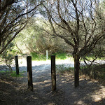
Turn sharp right: From the Jennifer street boardwalk track head on Cape Banks Rd, La Perouse (next to the golf course), this walk follows the ‘Jennifer Street Boardwalk’ sign[144], through the narrow timber bollards

and along the concrete footpath for about 35m to find a timber seat

.
From the seat, this walk follows the timber boardwalk uphill through the lovely forest, after another 30m where the path becomes moderately steep[145]

for about 15m. The boardwalk continues less steeply uphill through the forest with the occasional water glimpses for 80m where it passes the fenced ‘revegetation area’[146]. The boardwalks gently undulates, mostly gently uphill for another 160m to find the large sheltered ‘Eastern Suburbs Banksia Scrub’ sign[147] shelter to find a timber seat

.
Soon after this sign, this walk joins a concrete footpath that leads you past the ‘Botany Bay National Park – Jennifer Street Lands’ sign[148] than between the timber bollards[149] (1.7m gap) to find the end of Jennifer St (near Marconi Pl), Little Bay[150].
Jennifer Street Boardwalk
Jennifer Boardwalk provides you with an elevated view through a rare and endangered ecological community known as the Eastern Suburbs Banksia Scrub. This community of native plants is protected under the Threatened Species Conservation Act. These Banksia once occupied around 5,300 hectares of land between North Head and Botany Bay in Sydney’s eastern suburbs. Currently, surviving stands totalling approximately 146 hectares have been recorded by the local government areas of Botany, Randwick, Waverley, and Manly .
(5.54km) Int of Jennifer Street Boardwalk AND Jennifer Street → Int of Anzac Parade ANDHenry Head Track
900 m
17 mins
2m
-31m
Easy track
Turn right: From the ‘Botany Bay National Park, Jennifer Street Lands’ sign[153] on Jennifer Street, this walk follows Jennifer St north (passing Marconi Place on the left) for about 110m, coming to a three-way intersection, with Grose St (on the left). The walk turns left here and follows Grose St for about 700m before coming to a four-way intersection. Here, the walk turns left into Anzac Parade, following beside this road for about 140m until coming to a car park[154] and grassed park[155] (on the left).
(6.45km) Int of Anzac Parade AND Henry Head Track → Southern end of Cann Park
370 m
6 mins
1m
-4m
Easy track
Continue straight: From the car park and grassed park[156], this walk follows the footpath south, with Anzac Parade on your right. Approximately 300m along footpath[157] (the footpath briefly separates[158] from the road and then returns), the walk finds the northern end of Cann Park[159] and ‘Cann Park’ sign[160]. This walk then follows the footpath towards the coast (and past the snake pit) for about 100m, until coming to the southern end of Cann Park and ‘Congwong Beach Walk’ sign[161] .
Maps for the Henry Head Circuit walk
You can download the PDF for this walk to print a map.
These maps below cover the walk and the wider area around the walk, they are worth carrying for safety reasons.
| Botany Bay | 1:25 000 Map Series | 91303S BOTANY BAY | NSW-91303S |
| Bondi | 1:25 000 Map Series | 91302S BONDI | NSW-91302S |
| Sydney | 1:100 000 Map Series | 9130 SYDNEY | 9130 |
Cross sectional view of the Henry Head Circuit bushwalking track
Analysis and summary of the altitude variation on the Henry Head Circuit
Overview of this walks grade – based on the AS 2156.1 – 2001
Under this standard, a walk is graded based on the most difficult section of the walk.
| Length | 6.8 km | ||
| Time | 3 hrs | ||
| . | |||
| Grade 4/6 Hard track |
AS 2156.1 | Gradient | Very steep (4/6) |
| Quality of track | Rough track, where fallen trees and other obstacles are likely (4/6) | ||
| Signs | Minimal directional signs (4/6) | ||
| Experience Required | Moderate level of bushwalking experience recommended (4/6) | ||
| Weather | Storms may impact on navigation and safety (3/6) | ||
| Infrastructure | Limited facilities (such as cliffs not fenced, significant creeks not bridged) (4/6) |
Some more details of this walks Grading
Here is a bit more details explaining grading looking at sections of the walk
Gradient
3.5km of this walk has gentle hills with occasional steps and another 2.3km has short steep hills. Whilst another 850m is very steep and the remaining 95m is flat with no steps.
Quality of track
3km of this walk follows a clear and well formed track or trail and another 1.3km follows a rough track, where fallen trees and other obstacles are likely. Whilst another 1.3km follows a smooth and hardened path and the remaining 1.2km follows a formed track, with some branches and other obstacles.
Signs
4.2km of this walk is clearly signposted and another 1.3km has minimal directional signs. The remaining (1.3km) has directional signs at most intersection.
Experience Required
4.7km of this walk requires no previous bushwalking experience and another 1.3km requires a leader a with moderate level of bushwalking experience. The remaining (800m) requires some bushwalking experience.
weather
Around 6km of this walk is not usually affected by severe weather events (that would unexpectedly impact safety and navigation), whilst the remaining 1.3km is affected by storms that may impact your navigation and safety.
Infrastructure
3.9km of this walk is close to useful facilities (such as fenced cliffs and seats) and another 1.6km has limited facilities (such as not all cliffs fenced). The remaining (1.3km) has limited facilities (such as cliffs not fenced, significant creeks not bridged).
Similar walks
A list of walks that share part of the track with the Henry Head Circuit walk.
496 m Return
15 mins
Easy track
750 m Return
30 mins
Easy track
1.1 km Return
30 mins
Moderate track
1.5 km Return
45 mins
Hard track
1.9 km Return
1 hr 30 mins
Hard track
4.2 km Return
1 hr 30 mins
Moderate track
6.6 km Circuit
3 hrs
Hard track
13 km One way
5 hrs
Hard track
13.4 km One way
5 hrs
Hard track
Other Nearby walks
A list of walks that start near the Henry Head Circuit walk.
866 m Return
30 mins
Easy track
792 m Circuit
30 mins
Easy track
8.8 km Return
3 hrs
Moderate track
960 m Circuit
20 mins
Easy track
2.8 km Circuit
1 hr 30 mins
Moderate track
1.1 km One way
30 mins
Very easy
8.9 km Return
3 hrs
Moderate track
5.7 km One way
2 hrs 30 mins
Hard track
7.4 km Return
2 hrs 30 mins
Moderate track
12.7 km One way
4 hrs 15 mins
Hard track
5 km One way
1 hr 45 mins
Hard track
5.5 km Return
2 hrs
Moderate track
Plan your trip to and from the walk here
The Henry Head Circuit walk starts and ends at the Southern End of Cann Park (gps: -33.988579, 151.23365)
Your transport options to Southern End of Cann Park are by;
![]() Bus. (get details)
Bus. (get details)
![]() Car. There is free parking available.
Car. There is free parking available.
(get details)
Short URL = http://wild.tl/hhc
Gallery images
There are other downloads I am still working on.
You will probably need to login to access these — still all free.
* KML (google earth file)
* GPX (GPS file)
Special Maps/ brochures
* A3 topo maps
* PDF with Lands Topo map base
* PDF with arial image (and map overlay)
I wanted to get the main site live first, this extra stuff will come in time.
Happy walking
Matt 🙂
Jennifer Street Boardwalk
And Walk
Jennifer Street Boardwalk

30 mins
750 m Return
6 m
Easy track
This walk guides you along raised boardwalk through rare and engaged banksia ecosystem. An opportunity to appreciate a sensitive environment close up and in an environmentally sensitive way. The information sign at the start of the walk provides insight into the Banksia scrub and its value. This walk is recommended if you would like to look at a type of vegetation that once covered a much larger area of Sydney. This walk is mostly downhill from Jennifer St. If the return trip is too much you can organise for someone to pick you up from Cape Banks Rd.


Jennifer Street Boardwalk
Jennifer Boardwalk provides you with an elevated view through a rare and endangered ecological community known as the Eastern Suburbs Banksia Scrub. This community of native plants is protected under the Threatened Species Conservation Act. These Banksia once occupied around 5,300 hectares of land between North Head and Botany Bay in Sydney’s eastern suburbs. Currently, surviving stands totalling approximately 146 hectares have been recorded by the local government areas of Botany, Randwick, Waverley, and Manly .
(0km) Int of Jennifer Street Boardwalk & Jennifer Street → Int of Cape Banks Rd & Jennifer Street Boardwalk
380 m
6 mins
0m
-6m
Easy track
From the end of Jennifer St (near Marconi Pl), Little Bay[3], this walk follows the concrete footpath between the timber bollards[4] (1.7m gap), past the ‘Botany Bay National Park – Jennifer Street Lands’ sign[5]. After about 25m, the walk passes the large sheltered ‘Eastern Suburbs Banksia Scrub’ sign[6] shelter to find a timber seat
.
The timber boardwalk leads gently downhill through the dense heath[7] for about 160m to pass the fenced ‘revegetation area’[8]. The boardwalk continues to lead through the forest with the occasional water glimpses for another 80m where the path starts to lead moderately steeply downhill[9]
for about 15m before starting to mostly level out again. At the end of the timber boarwalk[10], the walk follows the concrete path to find another timber seat
. From here the walk continues along the footpath for 35m to pass the ‘Jennifer Street Boardwalk’ sign[11], head through the narow timber bollards
and come to Cape Banks Rd, La Perouse next to the golf course.
Maps for the Jennifer Street Boardwalk walk
You can download the PDF for this walk to print a map.
These maps below cover the walk and the wider area around the walk, they are worth carrying for safety reasons.
| Botany Bay | 1:25 000 Map Series | 91303S BOTANY BAY | NSW-91303S |
| Sydney | 1:100 000 Map Series | 9130 SYDNEY | 9130 |
Cross sectional view of the Jennifer Street Boardwalk bushwalking track
Analysis and summary of the altitude variation on the Jennifer Street Boardwalk
Accessibility summary information for the Jennifer Street Boardwalk
Parking: There are 0 designated accessible parking areas on this walk.
Toilets: There are 0 designated accessible toilets on this walk.
Seats: There are 2 places to sit on this walk.
They are 340m apart.
Hazards: There are 1 specific noteable accessability related hazards on this walk.
Wheelchair Steep An approximalty 15m section of the boardwalk is 1.5:12 steep. Found about 270m into the walk.
Accessibility Details


Overview of this walks grade – based on the AS 2156.1 – 2001
Under this standard, a walk is graded based on the most difficult section of the walk.
| Length | 750 m | ||
| Time | 30 mins | ||
| . | |||
| Grade 2/6 Easy track |
AS 2156.1 | Gradient | Gentle hills with occasional steps (2/6) |
| Quality of track | Smooth and hardened path (1/6) | ||
| Signs | Clearly signposted (1/6) | ||
| Experience Required | No experience required (1/6) | ||
| Weather | Weather generally has little impact on safety (1/6) | ||
| Infrastructure | Generally useful facilities (such as fenced cliffs and seats) (1/6) |
Some more details of this walks Grading
Here is a bit more details explaining grading looking at sections of the walk
Gradient
This whole walk, 380m has gentle hills with occasional steps.
Quality of track
This whole walk, 380m follows a smooth and hardened path.
Signs
This whole walk, 380m is clearly signposted.
Experience Required
This whole walk, 380m requires no previous bushwalking experience.
weather
This whole walk, 380m is not usually affected by severe weather events (that would unexpectedly impact safety and navigation).
Infrastructure
This whole walk, 380m is close to useful facilities (such as fenced cliffs and seats).
Similar walks
A list of walks that share part of the track with the Jennifer Street Boardwalk walk.
6.6 km Circuit
3 hrs
Hard track
6.8 km Circuit
3 hrs
Hard track
Other Nearby walks
A list of walks that start near the Jennifer Street Boardwalk walk.
792 m Circuit
30 mins
Easy track
4.2 km Return
1 hr 30 mins
Moderate track
13 km One way
5 hrs
Hard track
1.1 km Return
30 mins
Moderate track
866 m Return
30 mins
Easy track
1.9 km Return
1 hr 30 mins
Hard track
496 m Return
15 mins
Easy track
1.5 km Return
45 mins
Hard track
8.8 km Return
3 hrs
Moderate track
960 m Circuit
20 mins
Easy track
2.8 km Circuit
1 hr 30 mins
Moderate track
1.1 km One way
30 mins
Very easy
Plan your trip to and from the walk here
The Jennifer Street Boardwalk walk starts and ends at the Int of Jennifer Street Boardwalk & Jennifer Street (gps: -33.985259, 151.24085)
Your transport options to Int of Jennifer Street Boardwalk & Jennifer Street are by;
![]() Bus. (get details)
Bus. (get details)
![]() Car. There is free parking available.
Car. There is free parking available.
(get details)
Short URL = http://wild.tl/jsb
Gallery images
There are other downloads I am still working on.
You will probably need to login to access these — still all free.
* KML (google earth file)
* GPX (GPS file)
Special Maps/ brochures
* A3 topo maps
* PDF with Lands Topo map base
* PDF with arial image (and map overlay)
I wanted to get the main site live first, this extra stuff will come in time.
Happy walking
Matt 🙂
Botany Bay Discovery Centre to Cape Baily

3 hrs
8.8 km Return
152 m
Moderate track
This walk explores the heath and the great views between the Visitor Center and Cape Baily Lighthouse. The walk follows a mixture of service trails, bush tracks, rock platforms and sand dunes, as it makes it’s way through the park. You will discover expansive views of the park and out to sea. There are even the occasional glimpses of the city.


Visitor Centre
This visitors’ centre can be found on Cape Solander Drive, inside Kamay Botany Bay National Park. It provides great information about the area’s history and environment, plus there is a souvenir shop, where some simple food and drink is also available. A Trailrider is also available for free hire for people with limited mobility. There is a male & female toilet block
on the eastern side of the Visitor Centre. And a large parking area
in front.
(0km) Kamay Botany Bay Visitor Centre → Cape Solander Dr int.
150 m
3 mins
2m
-1m
Easy track
From the front of the ‘Visitor Centre’[2]

, this walk follows the footpath[3] that then leads through the middle of the car park
[4], to find the pebblecrete footpath and ‘Banks-Solander Track’ sign[5] on the far side. This walk follows this sign along the narrow (1.4m) path [6], timber boardwalk[7] then dirt track[8] as it winds through the dense forest for nearly 100m to find a seat[9]

just before the road. The walk then leads up the rise to then crossing (taking care) Cape Solander Drive[10] to the intersection marked with a large ‘Yena Trail’ map sign[11].
(0.15km) Cape Solander Dr int. → Int of Yena Servicetrail and Kurnell Lookout Trail
440 m
8 mins
16m
0m
Easy track
Continue straight: From the intersection, this walk follows the ‘Banks-Solander Track’ arrow[12] gently uphill along the gravelly trail for about 50m to find a 3-way intersection[13] marked with a small ‘The Banks-Solander Track’ plaque[14] (with a narrower track on the left).
Continue straight: From the intersection, this walk follows the wide, mostly flat gravelly trail[15] south (further away from the road) for a little over 200m, until coming to an intersection with the other end of ‘Banks Solander Track’ (with a timber boardwalk on the left)[16].
Continue straight: From the intersection, this walk heads south along the gravelly management trail until coming to an intersection with a bush track on the left.
(0.59km) Int of Yena Servicetrail and Kurnell Lookout Trail → Int of Yena Servicetrail and link track
70 m
2 mins
4m
0m
Easy track
Veer left: From the intersection, the walk follows the main management trail to the south-east through the open ferny forest. Soon, the Yena trail meets the radar track (on the right).
(0.66km) Int of Yena Servicetrail and link track → Int of Cape Bailey and link track
480 m
8 mins
8m
-7m
Moderate track
Turn right: From the intersection, this walk heads south along a sandy bush track towards the water tank and radar tower. This is a very sandy trail, with several small ups and downs along the way to a ‘T’ intersection with a wide bush track – just to the west of here (approximately 5m), there is another intersection with a service trail.
(1.14km) Int of Cape Bailey and link track → Int of Cape Bailey track and the radar service trail
380 m
6 mins
6m
-3m
Moderate track
Turn left: From the intersection, the walk initially heads east, then turns right along the wide bush track, keeping the water tank and the radar on the right as it winds through the heath forest, coming to a four-way intersection with a wide management trail.
(1.52km) Int of Cape Bailey track and the radar service trail → Int of Cape Bailey and car park tracks
290 m
5 mins
0m
-4m
Moderate track
Veer left: From the intersection, the walk heads south (with the water tank directly behind) along the sandy bush track, and then along the rock-shelf until coming to an intersection marked by several arrows.
(1.8km) Int of Cape Bailey and car park tracks → Tabbigai Gap Track Int
1 km
17 mins
10m
-19m
Moderate track
Turn right: From the intersection, this walk heads south (keeping the ocean to the left, about 150m away) along the rock and the sandy track, through the low dense scrub. Along this part of the track, there are several sections where wind and water erosion has developed small holes along the rock shelf that give it a very interesting look. After some time, this walk passes a small bush track on the left (which heads out to the coast), and shortly after this, comes to an intersection with a service trail at Tabbigai Gap.
(2.81km) Tabbigai Gap Track Int → Sand dune int
550 m
9 mins
8m
-6m
Moderate track
Veer left: From the Tabbigai Gap, this walk follows the clear, sandy track east (with the Tabbigai Gap on the left) up a short hill until it turns right at the small clearing. The track stays away from the ocean and soon comes to a large sand dune clearing. From the other end of the clearing, the walk follows the track south (ocean on the left) through the thick scrub, winding along until it rises up a hill to a long sand dune clearing. From the far end of this clearing, the walk follows the overgrown track through the thick scrub, until it widens out a little and continues south for a short distance, to the intersection in the pit of a sand dune, with a large hanging swamp on the right.
Hanging Swamps
There are a number of hanging swamps that can be found along the Cape Bailey walk. They are home to a number of different plants and animals like reeds and frogs. Hanging swamps are formed on high ground when rainfall seeps out of surrounding hills and accumulates in a slight depression, over time forming a swamp. Interestingly, they are sometimes difficult to see from far away as the thick build up of reeds and other plant life often cover the water.
(3.36km) Sand dune int → Int of Cape Bailey lighthouse track
950 m
18 mins
28m
-22m
Moderate track
Turn right: From the intersection, this walk follows the narrow bush track that heads west to the top of the dunes. (From the top of the dune there are some great views of the hanging swamp straight ahead). The track then turns left and drops off the top of the sand dune, keeping the swamp on the right. The track then climbs a sandy hill to some more views before turning left and heading along a sandy track, through several more large sand dunes. After these dunes, the track starts to flatten out and widen, to head along to an intersection with a bush track (which heads to the lighthouse).
(4.31km) Int of Cape Bailey Lighthouse track → Cape Bailey Lighthouse
80 m
2 mins
8m
0m
Moderate track
Veer right: From the intersection, this walk follows the sandy bush track, heading up and away from the ocean. The track is relatively defined for most of the way, however in the last 20m the track becomes quite overgrown and a little less defined (the lighthouse is always visible). Once at the lighthouse, there are good views inland, however the views to the east are largely blocked by the high scrub.
Cape Baily Lighthouse
Established in 1950, the lighthouse was required so north-bound shipping could hug the coast and avoid the strong southerly currents further out to sea. This lighthouse can be found a stone’s-throw from the Cape Baily coastal walk, about 1.5 kilometres north from the Joseph Banks Drive car park. More info.
Maps for the Botany Bay Discovery Centre to Cape Baily walk
You can download the PDF for this walk to print a map.
These maps below cover the walk and the wider area around the walk, they are worth carrying for safety reasons.
| Port Hacking | 1:25 000 Map Series | 91294N PORT HACKING | NSW-91294N |
| Port Hacking | 1:100 000 Map Series | 9129 PORT HACKING | 9129 |
Cross sectional view of the Botany Bay Discovery Centre to Cape Baily bushwalking track
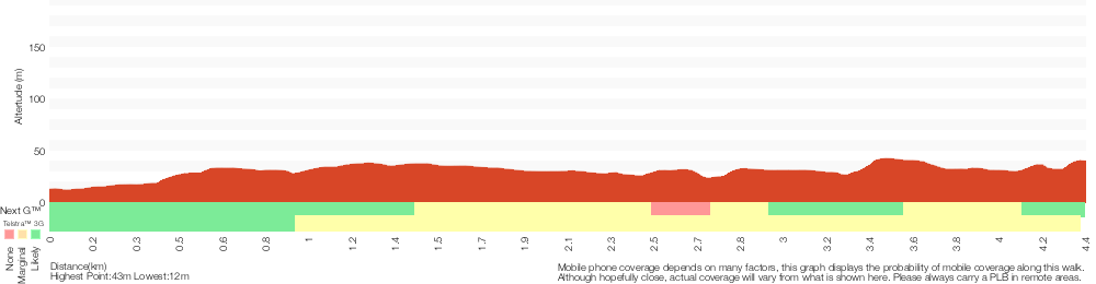
Analysis and summary of the altitude variation on the Botany Bay Discovery Centre to Cape Baily
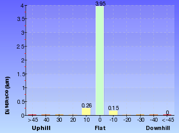
Overview of this walks grade – based on the AS 2156.1 – 2001
Under this standard, a walk is graded based on the most difficult section of the walk.
| Length | 8.8 km | ||
| Time | 3 hrs | ||
| . | |||
| Grade 3/6 Moderate track |
AS 2156.1 | Gradient | Short steep hills (3/6) |
| Quality of track | Formed track, with some branches and other obstacles (3/6) | ||
| Signs | Directional signs along the way (3/6) | ||
| Experience Required | Some bushwalking experience recommended (3/6) | ||
| Weather | Weather generally has little impact on safety (1/6) | ||
| Infrastructure | Limited facilities, not all cliffs are fenced (3/6) |
Some more details of this walks Grading
Here is a bit more details explaining grading looking at sections of the walk
Gradient
2.5km of this walk has short steep hills and another 1.4km has gentle hills with occasional steps. The remaining (510m) is flat with no steps.
Quality of track
Around 3.1km of this walk follows a formed track, with some branches and other obstacles, whilst the remaining 1.3km follows a clear and well formed track or trail.
Signs
Around 3.3km of this walk has directional signs at most intersection, whilst the remaining 1.1km is clearly signposted.
Experience Required
Around 2.7km of this walk requires no previous bushwalking experience, whilst the remaining 1.7km requires some bushwalking experience.
weather
This whole walk, 4.4km is not usually affected by severe weather events (that would unexpectedly impact safety and navigation).
Infrastructure
Around 3.7km of this walk has limited facilities (such as not all cliffs fenced), whilst the remaining 660m is close to useful facilities (such as fenced cliffs and seats).
Similar walks
A list of walks that share part of the track with the Botany Bay Discovery Centre to Cape Baily walk.
960 m Circuit
20 mins
Easy track
2.8 km Circuit
1 hr 30 mins
Moderate track
3.8 km One way
1 hr 30 mins
Hard track
5 km One way
1 hr 45 mins
Hard track
5.4 km One way
2 hrs 30 mins
Hard track
5.5 km Return
2 hrs
Moderate track
5.7 km One way
2 hrs 30 mins
Hard track
7.4 km Return
2 hrs 30 mins
Moderate track
8.9 km Return
3 hrs
Moderate track
12.7 km One way
4 hrs 15 mins
Hard track
13.1 km One way
4 hrs 30 mins
Hard track
Other Nearby walks
A list of walks that start near the Botany Bay Discovery Centre to Cape Baily walk.
1.1 km One way
30 mins
Very easy
866 m Return
30 mins
Easy track
4.2 km Return
1 hr 30 mins
Moderate track
13 km One way
5 hrs
Hard track
6.6 km Circuit
3 hrs
Hard track
6.8 km Circuit
3 hrs
Hard track
1.1 km Return
30 mins
Moderate track
792 m Circuit
30 mins
Easy track
1.5 km Return
45 mins
Hard track
496 m Return
15 mins
Easy track
1.9 km Return
1 hr 30 mins
Hard track
750 m Return
30 mins
Easy track
Plan your trip to and from the walk here
The Botany Bay Discovery Centre to Cape Baily walk starts and ends at the Kamay Botany Bay Visitor Centre (gps: -34.00506, 151.22162)
Your transport options to Kamay Botany Bay Visitor Centre are by;
![]() Bus. (get details)
Bus. (get details)
![]() Car. There is free parking available.
Car. There is free parking available.
(get details)
Short URL = http://wild.tl/bbdctcb
Gallery images
There are other downloads I am still working on.
You will probably need to login to access these — still all free.
* KML (google earth file)
* GPX (GPS file)
Special Maps/ brochures
* A3 topo maps
* PDF with Lands Topo map base
* PDF with arial image (and map overlay)
I wanted to get the main site live first, this extra stuff will come in time.
Happy walking
Matt 🙂
La Perouse Historical Walk
And Walk
La Perouse Historical Walk

30 mins
792 m Circuit
9 m
Easy track
This walk, primarily across open lawns, offers views across Botany Bay while visiting historically significant landmarks. The side trip to the Bare Island Fortifications is well worth it, with tours available on Sunday afternoons. However, a walk across to the locked gate on Bare Island is still well worth the time – also, there are steps at the far side of the bridge down onto attractive unfenced rock platforms. Both the historic tombstone and monument by the museum are worth a visit, to contemplate our early explorers. Food, beach and a children’s playground are available close to the end of this walk. A magnificent location with so much history.
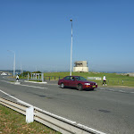
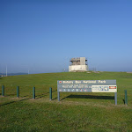

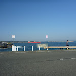

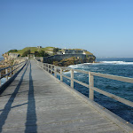
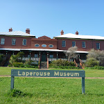


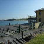


(0km) Southern End of Cann Park → The Barrack Tower
140 m
2 mins
0m
0m
Easy track
From the southern end of Cann Park

(Anzac Parade, La Perouse)[1] and ‘Congwong Beach Walk’ sign[2], this walk initially follows a footpath toward the water and a stone tower[3]) for about 20m (past the road intersection) then turns right to cross Anzac Pd to find a ‘Botany Bay National Park’ sign[4]. This walk then passes between timber posts, walking across grass for about 50m, until coming to the locked stone tower (The Barrack Tower[5]).
(0.14km) The Barrack Tower → Top of Bare Island Trail
90 m
2 mins
2m
0m
Easy track
Continue straight: From the stone tower (The Barrack Tower[6]), this walk heads gently downhill, towards the water, over grass for about 80m. The walk then heads down the steps and across Anzac Rd[7] so find a few seats at the top of Bare Island Trail[8] beside the large ‘Botany Bay National Park’ sign[9].
(0.23km) Top of Bare Island trail → Bare Island Fortification
190 m
4 mins
3m
-13m
Easy track
Continue straight: From the intersection[10], this walk heads away from Anzac Parade

and seats

following the (initally moderalty steep

) driveway downhill[11] toward Bare Island, past the large ‘Botany Bay National Park’ sign[12]. This walk continues to follow the concrete then asphalt driveway for about 80m to find the start of the 100m long (3.8m wide) timber bridge[13]. This walk crosses the bridge[14], until coming to a large metal gate[15] and a ‘Bare Island Fortification’ sign[16] behind the gate. There are great views from the bridge. Bare Island is generally locked but guided tours are available. At the end of this side trip, retrace your steps back to the main walk then Turn left.
Bare Island Fortification
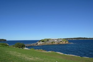
In 1885 the Bare Island Fortification on the northern side of Botany Bay was built in order to prevent foreign invasion and protect the water supply of the new colony. While the building is now accessible for tours, originally the only way of getting onto the island was by flying fox. The fortifications were decommissioned in the early 1900s. In 1912, Bare Island became a retirement home for war veterans from the Crimea, Sudan and China campaigns. It continued to operate as a retirement home until 1963, after this the Randwick District Historical Society became caretakers of the island. In 1967 it was passed onto the New South Wales Parks and Wildlife Service for use as a museum and tourist attraction. The Bare Island fort has now been declared a historical site. The Bare Island Fortification is available for tours on Sundays in the afternoons, for more information on how to book tours call 1300 072 757. There are many steps on the tour and is not considered wheelchair accessible. Bare Island is also one of the most popular scuba diving sites in New South Wales.
From the gate on the far side of the timber bridge is a steep set of timber steps that lead down to the rock platform [20], only access at low tide and seas.
From the gate on the far side of the timber bridge is a steep set of timber steps that lead down to the rock platform [20], only access at low tide and seas.
(0.23km) Int of Bare Island Fortification & Anzac Rd → LaPerouse Museum
230 m
4 mins
2m
-5m
Easy track
Turn right: From the intersection[21], this walk follows the gravel track for about 80m, keeping the road on the right and water on the left, to find a roadside car park. Then this walk crosses the road and then the grass for about 170m (towards the large brick building[22]) to find the LaPerouse Museum[23].
La Perouse Museum
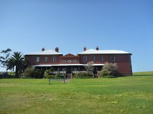
The La Perouse museum[24], in Botany Bay National Park, is housed in the historic cable station at La Perouse. The museum contains much information regarding Bare Island, the fate of La Perouse himself and Botany Bay National Park. There are many relics from ship wrecks, with maps and scientific instruments dating back to the 16th century. The museum contains over 2000 items, with one of the most significant collection items being a complete Atlas of the Voyage of La Perouse, consisting of 72 coloured drawings and maps, featuring places the expedition visited between 1785 and 1788. The museum is open Thursday to Sunday 10am to 4pm, closed Christmas Day.. Access to the building is via a steep staircase. More info.
Tombstone of Pere Receveur
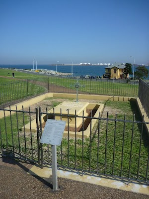
The tombstone near Bare Island belongs to Pere Receveur. Pere Laurent Receveur died on 17th February 1788 (due to injuries sustained en route in Samoa) and this grave is therefore the first known European grave on Australia’s soil. Receveur was a priest and botanist serving under De La Pereuse on the French scientific expedition to the Pacific. The tomb itself dates from 1829 but has since been restored several times .
Monument to De La Perouse
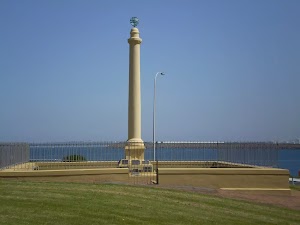
This monument to De La Perouse, near Cape Banks is named after Jean-Francois de Galaup (1741-88) (aka La Perouse), who landed on the northern shore of Botany Bay on 26 January 1788. Perouse’s ships, the Astrolabe and the Boussole, disappeared shortly after visiting Australia with no surviving crew, making the landing in Botany Bay the last known point of contact of the scientific expedition. More info.
(0.46km) LaPerouse Museum → Boatshed Cafe on Anzac Parade
110 m
2 mins
1m
-4m
Easy track
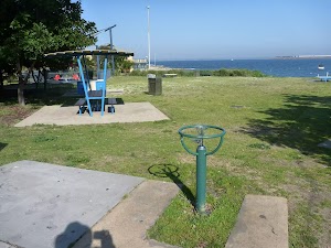
(0.58km) Boatshed Cafe on Anzac Parade → Southern End of Cann Park
220 m
4 mins
4m
0m
Easy track
Maps for the La Perouse Historical Walk walk
You can download the PDF for this walk to print a map.
These maps below cover the walk and the wider area around the walk, they are worth carrying for safety reasons.
| Botany Bay | 1:25 000 Map Series | 91303S BOTANY BAY | NSW-91303S |
| Sydney | 1:100 000 Map Series | 9130 SYDNEY | 9130 |
Cross sectional view of the La Perouse Historical Walk bushwalking track
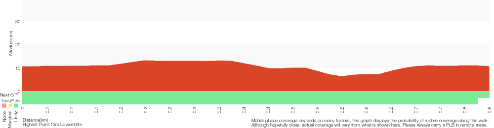
Analysis and summary of the altitude variation on the La Perouse Historical Walk
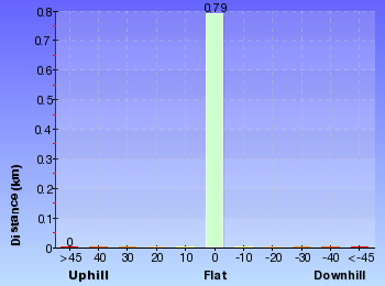
Overview of this walks grade – based on the AS 2156.1 – 2001
Under this standard, a walk is graded based on the most difficult section of the walk.
| Length | 792 m | ||
| Time | 30 mins | ||
| . | |||
| Grade 2/6 Easy track |
AS 2156.1 | Gradient | Gentle hills with occasional steps (2/6) |
| Quality of track | Clear and well formed track or trail (2/6) | ||
| Signs | Clearly signposted (1/6) | ||
| Experience Required | No experience required (1/6) | ||
| Weather | Weather generally has little impact on safety (1/6) | ||
| Infrastructure | Generally useful facilities (such as fenced cliffs and seats) (1/6) |
Some more details of this walks Grading
Here is a bit more details explaining grading looking at sections of the walk
Gradient
This whole walk, 790m has gentle hills with occasional steps.
Quality of track
This whole walk, 790m follows a clear and well formed track or trail.
Signs
This whole walk, 790m is clearly signposted.
Experience Required
This whole walk, 790m requires no previous bushwalking experience.
weather
This whole walk, 790m is not usually affected by severe weather events (that would unexpectedly impact safety and navigation).
Infrastructure
This whole walk, 790m is close to useful facilities (such as fenced cliffs and seats).
Similar walks
A list of walks that share part of the track with the La Perouse Historical Walk walk.
866 m Return
30 mins
Easy track
Other Nearby walks
A list of walks that start near the La Perouse Historical Walk walk.
4.2 km Return
1 hr 30 mins
Moderate track
13 km One way
5 hrs
Hard track
6.6 km Circuit
3 hrs
Hard track
6.8 km Circuit
3 hrs
Hard track
1.1 km Return
30 mins
Moderate track
750 m Return
30 mins
Easy track
1.9 km Return
1 hr 30 mins
Hard track
496 m Return
15 mins
Easy track
1.5 km Return
45 mins
Hard track
8.8 km Return
3 hrs
Moderate track
960 m Circuit
20 mins
Easy track
2.8 km Circuit
1 hr 30 mins
Moderate track
Plan your trip to and from the walk here
The La Perouse Historical Walk walk starts and ends at the Southern End of Cann Park (gps: -33.988562, 151.23369)
Your transport options to Southern End of Cann Park are by;
![]() Bus. (get details)
Bus. (get details)
![]() Car. There is free parking available.
Car. There is free parking available.
(get details)
Short URL = http://wild.tl/lphw
Gallery images
There are other downloads I am still working on.
You will probably need to login to access these — still all free.
* KML (google earth file)
* GPX (GPS file)
Special Maps/ brochures
* A3 topo maps
* PDF with Lands Topo map base
* PDF with arial image (and map overlay)
I wanted to get the main site live first, this extra stuff will come in time.
Happy walking
Matt 🙂
Cape Baily track from visitor centre (return)

3 hrs
8.9 km Return
175 m
Moderate track
This great return walk starts from the Discovery centre in Kurnell, and follows a series of bush tracks and service trails, that wind south through wooded forest, to the Cape Baily walking track. At about halfway, the track breaks into heath, winding in between hanging swamps and along the cliff tops to the Cape Baily Lighthouse. The lighthouse is a great spot for lunch before the return journey.

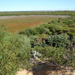
Visitor Centre
This visitors’ centre can be found on Cape Solander Drive, inside Kamay Botany Bay National Park. It provides great information about the area’s history and environment, plus there is a souvenir shop, where some simple food and drink is also available. A Trailrider is also available for free hire for people with limited mobility. There is a male & female toilet block
on the eastern side of the Visitor Centre. And a large parking area
in front.
(0km) Carpark → Int of Kurnell Lookout and Muru Tracks
260 m
5 mins
20m
0m
Easy track
From the main exit of the Botany Bay Discovery Centre car park, the track heads south-east, out of the car park along the old service trail (Not on the Banks Solander Track). Partway along, the track passes over a small bridge. This is shortly before an intersection with Cape Solander Drive. Just across the road, another service trail begins.
Continue straight: From Cape Solander Dr, this walk heads south-east away from the discovery centre and along the management trail for approximately 200m until coming to an intersection with a sandy track on the left.
Continue straight: From Cape Solander Dr, this walk heads south-east away from the discovery centre and along the management trail for approximately 200m until coming to an intersection with a sandy track on the left.
(0.26km) Int of Kurnell Lookout and Muru Tracks → Int of Yena Servicetrail and link track
440 m
10 mins
13m
-13m
Moderate track
Turn right: From the intersection, this walk heads south-west along the sandy track until coming to an intersection with another track on the left. Kurnell Lookout is at the top of the knoll at this intersection, view obstructed with trees
Continue straight: From the intersection at Kurnell Lookout, this walk heads south-west meandering along a narrow sandy bush track that has several small ups and downs. The track soon comes to an intersection with a wide management trail.
Turn left: From the intersection, the walk follows the main management trail to the south-east through the open ferny forest. Soon, the Yena trail meets the radar track (on the right).
(0.7km) Int of Yena Servicetrail and link track → Int of Cape Baily and link track
480 m
8 mins
8m
-7m
Moderate track
Turn right: From the intersection, this walk heads south along a sandy bush track towards the water tank and radar tower. This is a very sandy trail, with several small ups and downs along the way to a ‘T’ intersection with a wide bush track – just to the west of here (approximately 5m), there is another intersection with a service trail.
(1.17km) Int of Cape Baily and link track → Int of Cape Baily track and the radar service trail
380 m
6 mins
6m
-3m
Moderate track
Turn left: From the intersection, the walk initially heads east, then turns right along the wide bush track, keeping the water tank and the radar on the right as it winds through the heath forest, coming to a four-way intersection with a wide management trail.
(1.55km) Int of Cape Baily track and the radar service trail → Tabbigai Gap Track Int
1.3 km
22 mins
10m
-23m
Moderate track
Veer left: From the intersection, the walk heads south (with the water tank directly behind) along the sandy bush track, and then along the rock-shelf until coming to an intersection marked by several arrows.
Turn right: From the intersection, this walk heads south (keeping the ocean to the left, about 150m away) along the rock and the sandy track, through the low dense scrub. Along this part of the track, there are several sections where wind and water erosion has developed small holes along the rock shelf that give it a very interesting look. After some time, this walk passes a small bush track on the left (which heads out to the coast), and shortly after this, comes to an intersection with a service trail at Tabbigai Gap.
Turn right: From the intersection, this walk heads south (keeping the ocean to the left, about 150m away) along the rock and the sandy track, through the low dense scrub. Along this part of the track, there are several sections where wind and water erosion has developed small holes along the rock shelf that give it a very interesting look. After some time, this walk passes a small bush track on the left (which heads out to the coast), and shortly after this, comes to an intersection with a service trail at Tabbigai Gap.
(2.85km) Tabbigai Gap Track Int → Sand dune int
550 m
9 mins
8m
-6m
Moderate track
Veer left: From the Tabbigai Gap, this walk follows the clear, sandy track east (with the Tabbigai Gap on the left) up a short hill until it turns right at the small clearing. The track stays away from the ocean and soon comes to a large sand dune clearing. From the other end of the clearing, the walk follows the track south (ocean on the left) through the thick scrub, winding along until it rises up a hill to a long sand dune clearing. From the far end of this clearing, the walk follows the overgrown track through the thick scrub, until it widens out a little and continues south for a short distance, to the intersection in the pit of a sand dune, with a large hanging swamp on the right.
Hanging Swamps
There are a number of hanging swamps that can be found along the Cape Baily walk. They are home to a number of different plants and animals like reeds and frogs. Hanging swamps are formed on high ground when rainfall seeps out of surrounding hills and accumulates in a slight depression, over time forming a swamp. Interestingly, they are sometimes difficult to see from far away as the thick build up of reeds and other plant life often cover the water.
(3.39km) Sand dune int → Int of Cape Baily lighthouse track
950 m
18 mins
28m
-22m
Moderate track
Turn right: From the intersection, this walk follows the narrow bush track that heads west to the top of the dunes. (From the top of the dune there are some great views of the hanging swamp straight ahead). The track then turns left and drops off the top of the sand dune, keeping the swamp on the right. The track then climbs a sandy hill to some more views before turning left and heading along a sandy track, through several more large sand dunes. After these dunes, the track starts to flatten out and widen, to head along to an intersection with a bush track (which heads to the lighthouse).
(4.35km) Int of Cape Baily Lighthouse track → Cape Baily Lighthouse
80 m
2 mins
8m
0m
Moderate track
Veer right: From the intersection, this walk follows the sandy bush track, heading up and away from the ocean. The track is relatively defined for most of the way, however in the last 20m the track becomes quite overgrown and a little less defined (the lighthouse is always visible). Once at the lighthouse, there are good views inland, however the views to the east are largely blocked by the high scrub.
Cape Baily Lighthouse
Established in 1950, the lighthouse was required so north-bound shipping could hug the coast and avoid the strong southerly currents further out to sea. This lighthouse can be found a stone’s-throw from the Cape Baily coastal walk, about 1.5 kilometres north from the Joseph Banks Drive car park. More info.
Maps for the Cape Baily track from visitor centre (return) walk
You can download the PDF for this walk to print a map.
These maps below cover the walk and the wider area around the walk, they are worth carrying for safety reasons.
| Port Hacking | 1:25 000 Map Series | 91294N PORT HACKING | NSW-91294N |
| Port Hacking | 1:100 000 Map Series | 9129 PORT HACKING | 9129 |
Cross sectional view of the Cape Baily track from visitor centre (return) bushwalking track
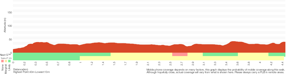
Analysis and summary of the altitude variation on the Cape Baily track from visitor centre (return)
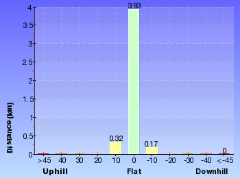
Overview of this walks grade – based on the AS 2156.1 – 2001
Under this standard, a walk is graded based on the most difficult section of the walk.
| Length | 8.9 km | ||
| Time | 3 hrs | ||
| . | |||
| Grade 3/6 Moderate track |
AS 2156.1 | Gradient | Short steep hills (3/6) |
| Quality of track | Formed track, with some branches and other obstacles (3/6) | ||
| Signs | Directional signs along the way (3/6) | ||
| Experience Required | Some bushwalking experience recommended (3/6) | ||
| Weather | Weather generally has little impact on safety (1/6) | ||
| Infrastructure | Limited facilities, not all cliffs are fenced (3/6) |
Some more details of this walks Grading
Here is a bit more details explaining grading looking at sections of the walk
Gradient
2.5km of this walk has short steep hills and another 1.7km has gentle hills with occasional steps. The remaining (170m) is flat with no steps.
Quality of track
Around 3.1km of this walk follows a formed track, with some branches and other obstacles, whilst the remaining 1.4km follows a clear and well formed track or trail.
Signs
Around 3.3km of this walk has directional signs at most intersection, whilst the remaining 1.2km is clearly signposted.
Experience Required
Around 2.7km of this walk requires no previous bushwalking experience, whilst the remaining 1.7km requires some bushwalking experience.
weather
This whole walk, 4.4km is not usually affected by severe weather events (that would unexpectedly impact safety and navigation).
Infrastructure
Around 4km of this walk has limited facilities (such as not all cliffs fenced), whilst the remaining 420m is close to useful facilities (such as fenced cliffs and seats).
Similar walks
A list of walks that share part of the track with the Cape Baily track from visitor centre (return) walk.
2.8 km Circuit
1 hr 30 mins
Moderate track
3.8 km One way
1 hr 30 mins
Hard track
5 km One way
1 hr 45 mins
Hard track
5.4 km One way
2 hrs 30 mins
Hard track
5.5 km Return
2 hrs
Moderate track
5.7 km One way
2 hrs 30 mins
Hard track
7.4 km Return
2 hrs 30 mins
Moderate track
8.8 km Return
3 hrs
Moderate track
12.7 km One way
4 hrs 15 mins
Hard track
13.1 km One way
4 hrs 30 mins
Hard track
Other Nearby walks
A list of walks that start near the Cape Baily track from visitor centre (return) walk.
960 m Circuit
20 mins
Easy track
1.1 km One way
30 mins
Very easy
866 m Return
30 mins
Easy track
4.2 km Return
1 hr 30 mins
Moderate track
13 km One way
5 hrs
Hard track
6.6 km Circuit
3 hrs
Hard track
6.8 km Circuit
3 hrs
Hard track
1.1 km Return
30 mins
Moderate track
792 m Circuit
30 mins
Easy track
1.5 km Return
45 mins
Hard track
496 m Return
15 mins
Easy track
1.9 km Return
1 hr 30 mins
Hard track
Plan your trip to and from the walk here
The Cape Baily track from visitor centre (return) walk starts and ends at the Carpark (gps: -34.005317, 151.22166)
Your transport options to Carpark are by;
![]() Bus. (get details)
Bus. (get details)
![]() Car. Parking fees apply in the area.
Car. Parking fees apply in the area.
(get details)
Short URL = http://wild.tl/cbtfvc
Gallery images
There are other downloads I am still working on.
You will probably need to login to access these — still all free.
* KML (google earth file)
* GPX (GPS file)
Special Maps/ brochures
* A3 topo maps
* PDF with Lands Topo map base
* PDF with arial image (and map overlay)
I wanted to get the main site live first, this extra stuff will come in time.
Happy walking
Matt 🙂
Comments