This walk visits some great lookouts and explores the lower section of Erskine Creek. Most of the walk along Erskine Creek is off track and the bush is quite thick in places. A great walk for people wanting to explore a remote area of the lower Blue Mountains National Park. You could make this an overnight walk and stay at Lower Lincoln Creek campsite.* This walk passes through very remote areas and sections have no visible track. At least one person in your group should have training and experience in off track walking and navigation. Even with these notes and a GPS these extra skills and equipment are required.
Erskine Creek via Pisgah Rock and Jack Evans


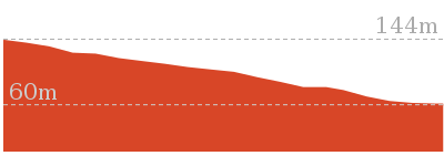
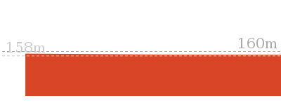
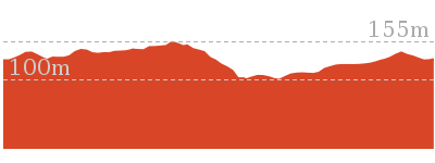
4 hrs 30 mins
7.1 km Circuit

421 m
Very experienced only


(0km) Pisgah Rock track head → Pisgah Rock Intersection

760 m
14 mins
21m
-17m
Moderate track
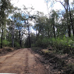
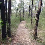
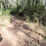
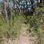
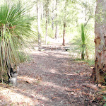
From the Pisgah Rock car park (2.2km further along Nepean Lookout Fire Trail from the Oaks Picnic Area), this walk follows the ‘Pisgah Rock 700mt’ sign along the old management trail. The track meanders through the Eucalypt and Casuarina forest as it climbs a gentle hill and then heads down the other side. The track soon comes to an intersection with a small bush track off to the left, from the intersection there are glimpses of the valley views.
(0.76km) Pisgah Rock Intersection → Attic Cave
250 m
6 mins
13m
-23m
Experienced only
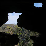
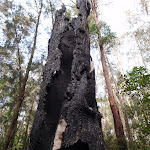
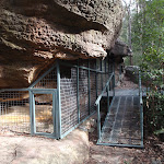
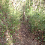
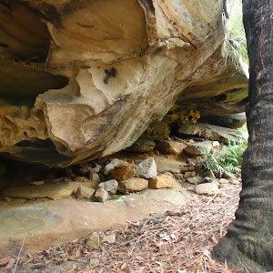
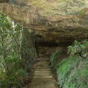
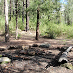
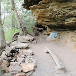
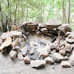
Turn right: From the intersection, the walk follows the old management trail that very soon narrows into a bush track as it heads away from the view (keeping the valley to the left). The tracks then emerges from the bush to cut across a rock shelf and into the scrub again. Once in the gully the track turns left to climb down the ‘V’ in the rock. At the bottom of the climb the walk heads right under the now obvious sandstone cave. The walk continues following the base of this cliff line along a fairly clear track passing several interesting sandstone overhangs. Soon the track comes to a large overhang and fire circle at Attic camping cave. At the end of this side trip, retrace your steps back to the main walk then Veer right.
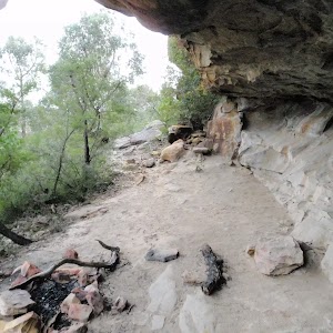
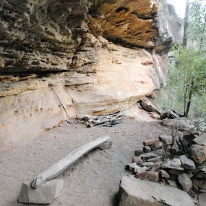
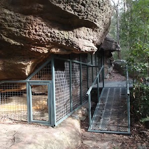
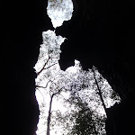
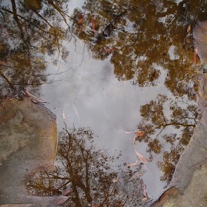
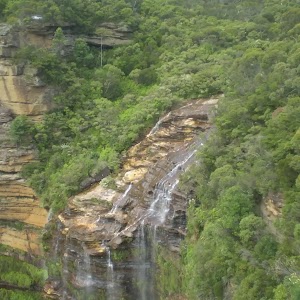
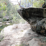
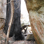
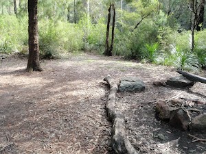
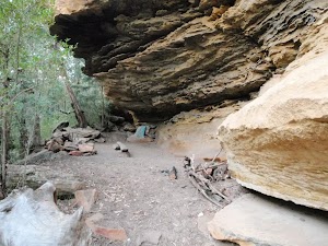
Attic Cave
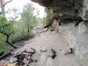
Attic Cave, near Pisgah Rock in the lower blue mountains is a large sandstone overhang. The cave has been used by walkers as an overnight camp for many decades. The cave could comfortably sleep about 5 people. There is a log book in a tin cake box on the rock shelf, making for some interesting reading, and awaiting your story. There is a fire circle, and the cave is reasonably well protected from the weather. The name Attic Cave is said to have come from the hole, a shelf, in the top of the cave, forming an attic.
(0.76km) Pisgah Rock Intersection → Pisgah Rock
20 m
1 mins
0m
-5m
Moderate track
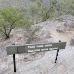
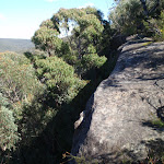
Veer left: From the intersection this walk takes the short bush track toward the view of the valley. The track comes to the unfenced cliff and great view from the top of Pisgah Rock and a sign posted ‘take care when walking near cliffs’.
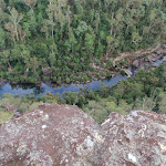
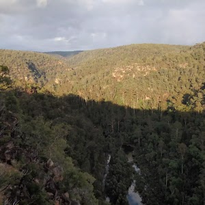
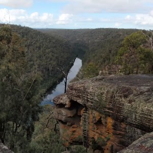
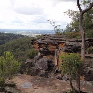
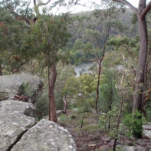
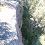
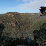
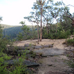
Pisgah Rock

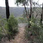
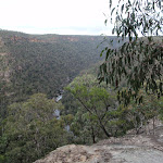
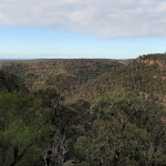
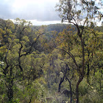
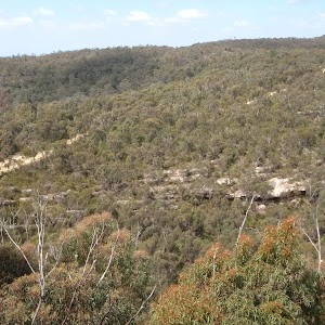
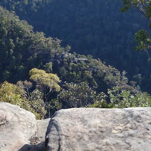
Pisgah Rock, is a short walk from Nepean Lookout Fire Trail in the lower Blue Mountains, and provides excellent views up Erskine Creek Gorge. The informal lookout is not fenced, and the surface is uneven with large crevasse like cracks. The view is simply amazing, with great views right up the middle of Erskine Creek Gorge. There are also great views to the left, down Erskine Creek Gorge and across the flats of the southern parts for greater Sydney. The rock presumably derives its name from the height point on Mount Nebo, where the Bible reports Moses seeing the promised land for the first time. In Hebrew pisgah refers to a high place. This Pisgah Rock is very much a high place, with great views.
(0.78km) Pisgah Rock → Junction of Erskine and Lincoln Crks
610 m
21 mins
18m
-200m
Very experienced only
Turn right: From the ‘take care when walking near cliffs’ signpost on Pisgah Rock this walk now follows the rock at the top of the cliff keeping the valley below to the left. After passing a couple of very steep looking cracks in the rock, the faint track comes to a much more gentle looking pass with a large Banksia growing out of it. The walk heads down through this pass. The track turns right and heads down a much steeper climb through the V in the rock. At the bottom of this climb the bush track leads to a small unfenced rock platform. The walk then turns right heading down the couple more climbs then turns left back under the rock platform. The track continues to wind down several more steep rocky climbs following a faint track and cairns. after most climbs the track generally tends left and down hill. After the last climb, the track heads away from the cliff making, tending left heading fairly steeply to an intersection near the junction of Erskine Creek and Lincoln Creek.
(1.38km) Junction of Erskine and Lincoln Creeks → Lower Lincoln Campsite
70 m
2 mins
3m
-4m
Experienced only
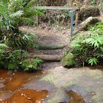
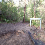
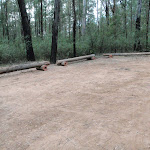
Turn right: From the intersection, this walk cross Lincoln Creek at the rock pools staying upstream of the small cascade (this may be impassable after rain). On the other side of the creek the walk picks up a faint track heading gently up the ridge. Soon the track opens up into a large campsite with some wonderful grass trees. At the end of this side trip, retrace your steps back to the main walk then Veer right.
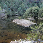
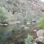
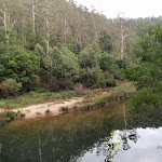
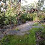
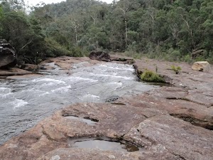
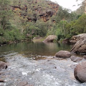
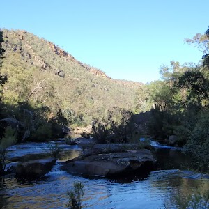
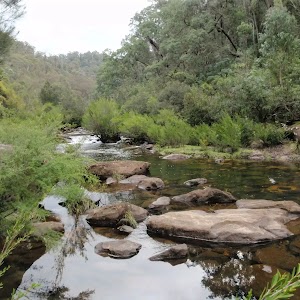
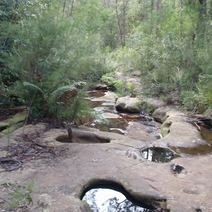
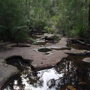
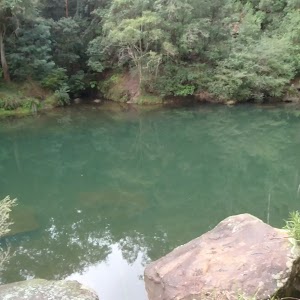
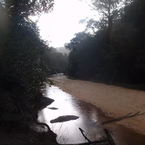
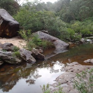
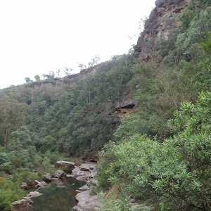
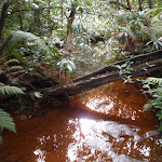
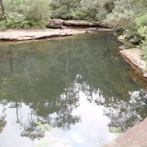
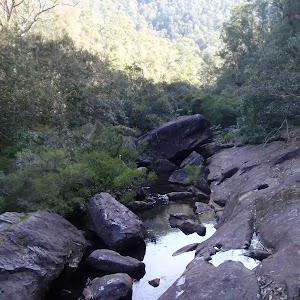
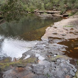
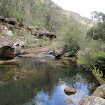
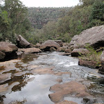
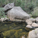
Junction of Erskine and Lincoln Creeks
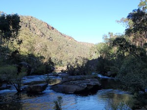
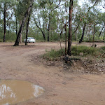
The junction of Erskine and Lincoln Creeks, in the Blue Mountains National park, occurs at a large rock platform. The rock platform contains many water holes, a few large square boulders and a few short cascades. There are breath taking views up looking Erskine Creek Gorge. Looking up to the escarpment, to the north east, there is a view of Pisgah Rock. This area floods after rain, but when water levels are normal, this can be a lovely place to rest and enjoy the creeks and gorge.
(1.38km) Junction of Erskine and Lincoln Creeks → Rock platform
260 m
7 mins
22m
-13m
Experienced only
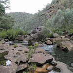
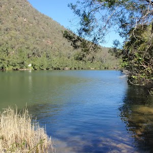
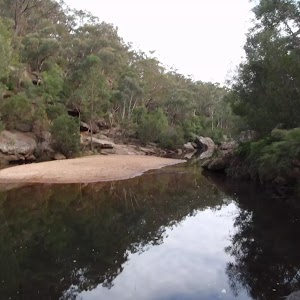
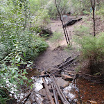
Continue straight: From the intersection, this walk head downstream along Erskine Creek, keeping the creek to the right. After following the indistinct bush track for a short while it leads to an large open rock platform. The walk continues along the rock until coming to the edge of a large pool at the bottom of the cascades.
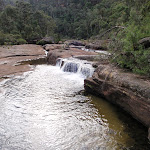
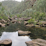
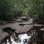
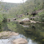
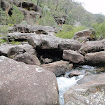
Rock Platform
This is a rock platform on Erskine creek about 200m downstream from the junction with Lincoln Creek. The area does flood so depending on water levels this is usually a large rock platform with some interesting water holes, and a lovely cascade flowing into a shallow pool. Although this lacks the majestic view up Erskine Creek (found a short distance upstream), this spot does provide an open spot, great for a snack, lunch and to rest.
(1.64km) Rock platform → Lower Erskine Campsite
2.3 km
51 mins
98m
-141m
Very experienced only
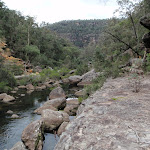
Veer left: From the end of the rock platform, the walk heads downstream initially by following the rock fall on the northern bank. There is a faint foot pad that lasts a short while. Find a good place to cross to the other bank (may be impassable after rain), where a rock shelf on the southern bank make walking easier. After passing the large gully the foot pad has all but disappeared, the walk continues down stream keeping the creek on the left. About half way along the large cliff high on the other side of the creek, the bank on the western side becomes difficult to pass due to another cliff. From here find a good place to cross (may be impassable after rain) and pick up the faint foot pad on the other side. The foot pad continues downstream (now with the creek on the right) and passes a few rock platforms at times. The track becomes more distinct as it gets closer to Jack Evans track. Not far before Jack Evans track the footpad comes to a small campsite with a fire circle on the left.
Lower Erskine Campsite

A small campsite, just up from the eastern bank of Erskine Creek, a short distance north of where Jack Evans track crosses the creek. The campsite has a small fire circle, and enough space for one maybe two tents. Erskine creek is a handy water supply (treat before drinking).
(3.91km) Lower Erskine Campsite → Int of Jack Evans Track and Erskine Creek
110 m
2 mins
4m
-2m
Experienced only
Continue straight: From the campsite this walk heads down stream keeping the creek to the right. Following a faint bush track the walk soon comes to an intersection with the Jack Evans Track just above a small sandy beach.
(4.02km) Int of Jack Evans Track and Erskine Creek → Int of Jack Evans and the lower Erskine tracks
100 m
2 mins
6m
-5m
Experienced only
Turn left: From the intersection just above sandy beach on the creek, this walk follows the clear bush track away from the creek and up the gentle hill. The track soon turns right and follows the creek on the right, downstream for a little while. The track then tends left up hill passing through a tunnel of vegetation to emerge onto an intersection with the more distinct Jack Evans and lower Erskine tracks
(4.12km) Int of Jack Evans and the lower Erskine tracks → Eastern side of natural dam wall
180 m
7 mins
30m
-17m
Experienced only
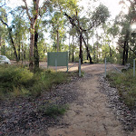
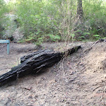
Turn right: From the intersection, this walk follows the wider bush track down hill keeping the sound of Erskine Creek to the right, soon the creek is in view. The track soon fades to a become a less distinct bush track leading up the bank away from the creek. The track climbs to a large boulder providing great views of the pool in Erskine Creek. The track then leads down to the natural charcoal deposits and continues along the creek edge to the water depth indicators. (A remote monitoring box is visible up the hill).
Veer left: From the water depth indicators this walk follows the creek down stream keeping Erskine Creek on the right. The faint bush track soon leads to the visible series of large boulders forming a natural dam wall. At the end of this side trip, retrace your steps back to the main walk then Veer right.
Veer left: From the water depth indicators this walk follows the creek down stream keeping Erskine Creek on the right. The faint bush track soon leads to the visible series of large boulders forming a natural dam wall. At the end of this side trip, retrace your steps back to the main walk then Veer right.
Natural dam pool

A series of very large boulders have formed a natural dam on Erskine Creek, about 170m north of Big Crater Creek. The dam forms a large lovely pool upstream. The pool is used by Sydney Water for measurements, and a water depth indicator is bolted to the rock. The pools is not safe to dive or jump into, there are many submerged objects.
(4.12km) Int of Jack Evans and the lower Erskine tracks → Erskine Lookout
850 m
31 mins
172m
-28m
Hard track
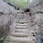
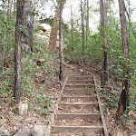
Veer left: From the intersection this walk follows the wider bush track up the hill past the large gum tree. The track then comes to, and climbs a series of timber steps up to a distinct saddle. The track continues gently up the hill for a short distance to come to an intersection with the faint short cut track off to the right.
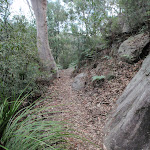
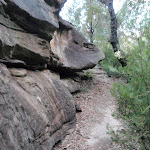
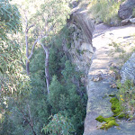
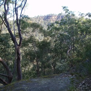
Continue straight: From the intersection this walk follows the wider bush track up the gentle hill. The track is narrow in places with a drop off to the right. The track then starts to climb the hill using a series of steps and switch backs to wind up through the wonderful sandstone outcrops. The track passes a few nice caves and through gaps in the rock. After the last steep section the track comes to a large rock platform on the left (with some great views). The track continues to follow the main path up the hill, and passes a long sandstone wall on the left of the track. Soon after this sandstone wall, the track comes to a wide sandy patch, with and unfenced rock platform and view on the left. This is the Erskine Lookout, an informal unfenced lookout.
Continue straight: From the intersection this walk follows the wider bush track up the gentle hill. The track is narrow in places with a drop off to the right. The track then starts to climb the hill using a series of steps and switch backs to wind up through the wonderful sandstone outcrops. The track passes a few nice caves and through gaps in the rock. After the last steep section the track comes to a large rock platform on the left (with some great views). The track continues to follow the main path up the hill, and passes a long sandstone wall on the left of the track. Soon after this sandstone wall, the track comes to a wide sandy patch, with and unfenced rock platform and view on the left. This is the Erskine Lookout, an informal unfenced lookout.
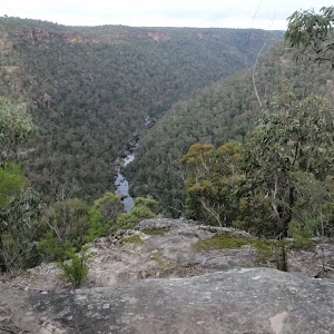
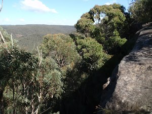
Erskine Lookout
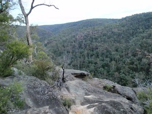
This informal and unfenced lookout on Jack Evans Track is in the lower Blue Mountains south west from the end of Nepean Lookout Fire Trail. The lookout is perched high above Erskine Creek and provides wonderful view upstream, and good views downstream. The view down in to the gorge gives a unique perspective of the lower section of Erskine Creek.
(4.97km) Erskine Lookout → End of Nepean Lookout Fire Trail
320 m
8 mins
29m
-1m
Moderate track
Continue straight: From Erskine Lookout, this walk heads up the gentle hill, following the sandy track, keeping the view to the left. The track passes some informal tracks to the left, passes a burnt ‘take care when walking near cliffs’ sign, and continues up the hill getting a little steeper. The track then comes to a silver information sign about ‘Jack Evans Track’. The track then bends left and comes to the car park at the end of the publicly accessible section of the Nepean Lookout Fire Trail.
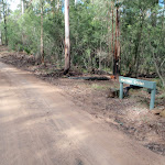
(5.3km) Car park at end of Nepean Lookout fire trail → Pisgah Rock track head
1.8 km
33 mins
51m
-9m
Easy track
Turn left: From the end of end of Nepean Lookout fire trail, this walk follows the road northward away from the locked gate initially keeping the car park to the left. The road soon comes to an intersection with Pisgah Ridge fire trail (a gated management trail on the right).
Veer left: From the intersection, this walk follows Nepean Lookout fire trail north west around the left hand bend. The road soon comes to the Machins Crater car park.
Continue straight: From the Machins Crater car park, this walk follows Nepean Lookout fire trail north west, up the hill, initially with Machins Crater track on the left. The road heads up the hill and soon comes the Pisgah Rock track head and car park.
Maps for the Erskine Creek via Pisgah Rock and Jack Evans walk
You can download the PDF for this walk to print a map.
These maps below cover the walk and the wider area around the walk, they are worth carrying for safety reasons.
| Penrith | 1:25 000 Map Series | 90303N PENRITH | NSW-90303N |
| Penrith | 1:100 000 Map Series | 9030 PENRITH | 9030 |
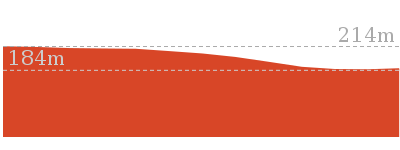
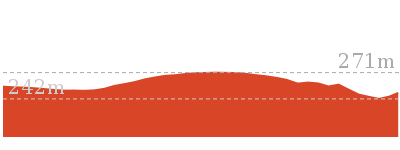
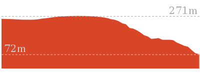
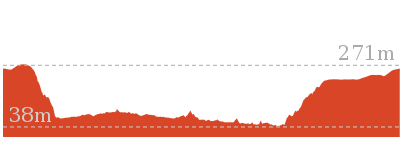
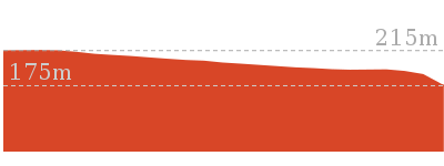
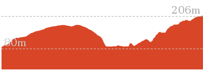
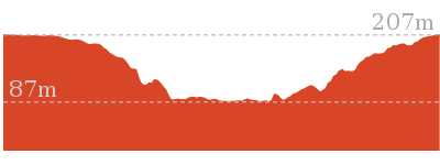
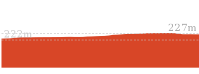
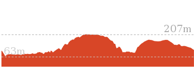
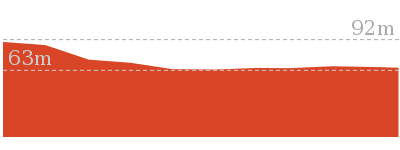
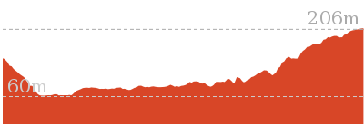
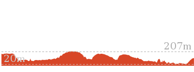
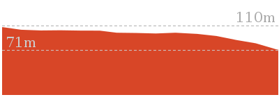
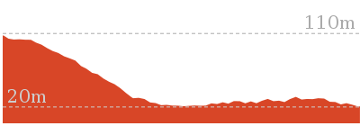
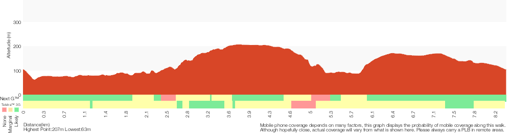
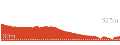
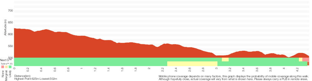
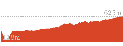
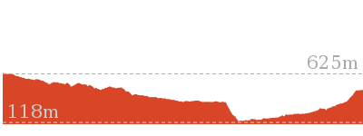
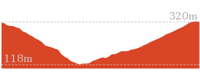
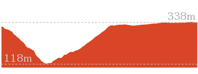
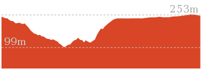
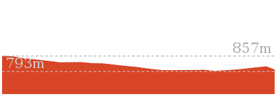
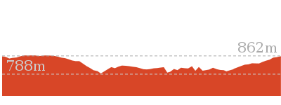
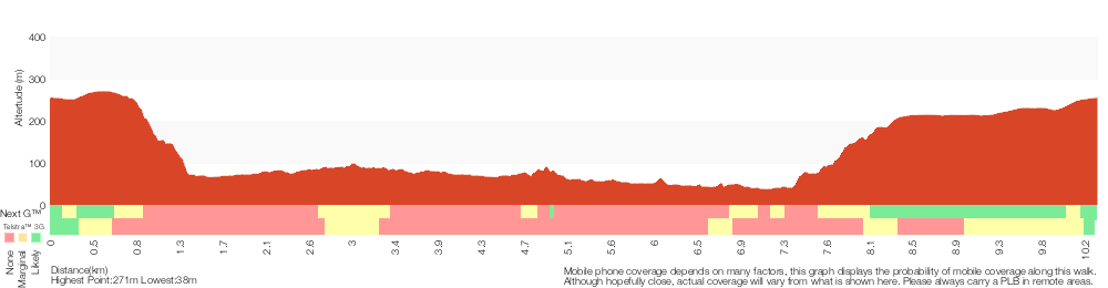
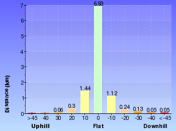
Cross sectional view of the Erskine Creek via Pisgah Rock and Jack Evans bushwalking track
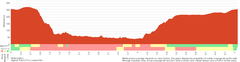
Analysis and summary of the altitude variation on the Erskine Creek via Pisgah Rock and Jack Evans
Overview of this walks grade – based on the AS 2156.1 – 2001
Under this standard, a walk is graded based on the most difficult section of the walk.
| Length | 7.1 km | ||
| Time | 4 hrs 30 mins | ||
| . | |||
| Grade 6/6 Very experienced only |
AS 2156.1 | Gradient | Very steep and difficult scrambles (5/6) |
| Quality of track | Off track (no visible track at times) (6/6) | ||
| Signs | No directional signs (5/6) | ||
| Experience Required | Very high level of bushwalking experience recommended (6/6) | ||
| Weather | Forecast, unforecast storms and severe weather may impact on navigation and safety (4/6) | ||
| Infrastructure | No facilities provided (5/6) |
Some more details of this walks Grading
Here is a bit more details explaining grading looking at sections of the walk
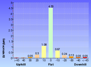
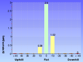
Gradient
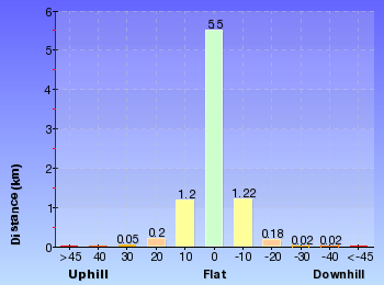
3.1km of this walk is very steep and another 2.6km has gentle hills with occasional steps. Whilst another 790m has short steep hills and the remaining 610m is very steep with difficult rock scrambles.
Quality of track
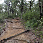
2.4km of this walk follows a smooth and hardened path and another 2.3km follows a known route where there is no visible track. Whilst another 1.4km follows a formed track, with some branches and other obstacles and a 760m section follows a clear and well formed track or trail. The remaining 260m follows a rough track, where fallen trees and other obstacles are likely.
Signs
3.3km of this walk Has no directional signs and another 1.8km is clearly signposted. Whilst another 1.1km has directional signs at most intersection and the remaining 850m has minimal directional signs.
Experience Required
2.6km of this walk requires no previous bushwalking experience and another 2.3km requires a leader with a high level of bushwalking experience. Whilst another 1.1km requires some bushwalking experience and a 610m section requires at least one leader with a very high level of bushwalking experience. The remaining 570m requires a leader a with moderate level of bushwalking experience.
weather
3.8km of this walk is not usually affected by severe weather events (that would unexpectedly impact safety and navigation) and another 2.3km is affected by forecast, unforecast storms and severe weather events that may impact on navigation and safety. The remaining (1.1km) is affected by storms that may impact your navigation and safety.
Infrastructure
3.1km of this walk has no facilities provided and another 1.8km is close to useful facilities (such as fenced cliffs and seats). Whilst another 1.7km has limited facilities (such as not all cliffs fenced) and the remaining 420m has limited facilities (such as cliffs not fenced, significant creeks not bridged).
Similar walks
A list of walks that share part of the track with the Erskine Creek via Pisgah Rock and Jack Evans walk.
648 m Return
20 mins
Moderate track
1.6 km Return
45 mins
Moderate track
2 km Return
1 Hr
Experienced only
2.6 km Return
2 hrs
Experienced only
2.8 km Return
3 hrs
Very experienced only
6 km Return
4 hrs
Very experienced only
10.3 km Circuit
2 Days
Very experienced only
Other Nearby walks
A list of walks that start near the Erskine Creek via Pisgah Rock and Jack Evans walk.
466 m Return
15 mins
Moderate track
1.3 km Return
30 mins
Moderate track
18.1 km One way
7 hrs
Hard track
4.3 km One way
1 hr 45 mins
Experienced only
2.8 km Circuit
1 hr 15 mins
Hard track
4.1 km Circuit
2 hrs
Moderate track
1 km Return
30 mins
Moderate track
512 m Return
30 mins
Hard track
8.3 km Circuit
3 hrs 45 mins
Hard track
8.4 km Circuit
3 hrs 45 mins
Experienced only
218 m Return
20 mins
Moderate track

522 m Return
20 mins
Hard track
Plan your trip to and from the walk here
The Erskine Creek via Pisgah Rock and Jack Evans walk starts and ends at the Pisgah Rock track head (gps: -33.828459, 150.5717)
Your main transport option to Pisgah Rock track head is by;
![]() Car. A park entry fee is required for driving into the park.
Car. A park entry fee is required for driving into the park.
(get details)


Short URL = http://wild.tl/ecvpraje
Gallery images
There are other downloads I am still working on.
You will probably need to login to access these — still all free.
* KML (google earth file)
* GPX (GPS file)
Special Maps/ brochures
* A3 topo maps
* PDF with Lands Topo map base
* PDF with arial image (and map overlay)
I wanted to get the main site live first, this extra stuff will come in time.
Happy walking
Matt 🙂
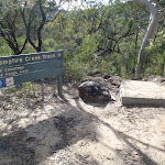
Red Hands Cave Circuit from Campfire Creek

3 hrs 45 mins
8.3 km Circuit
397 m
Hard track
This walk takes the lovely track up through Red Hands Gully to the amazing hand painting of Red Hands Caves. This historic and cultural feature is complemented by the Grinding Grooves along Campfire Creek. An excellent walk through some beautiful bush. There is a picnic area halfway – a great spot to stop for lunch.


(0km) Campfire Creek car park → Int. Red Hands Cave and Carpark Trk
190 m
7 mins
0m
-42m
Hard track
From the car park, the track follows the ‘Campfire Creek’ sign down the hill. The track steeply descends the hill, winding to a ‘Car Park’ sign (pointing back the way you came).
(0.19km) Campfire Creek sign side of Causeway → Int. Red Hands Cave and Carpark Trk
40 m
1 mins
2m
-1m
Moderate track
Continue straight: From the causeway, the walk follows the ‘Camp Fire Creek Track’ sign along the water’s edge to the signposts for ‘Red Hands Cave’ and ‘Car park’. Now Continue straight to join the main walk.
(0.19km) Int. Red Hands Cave and Carpark Trk → Red Hands Cave
3 km
1 hr 11 mins
206m
-91m
Moderate track
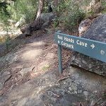
Turn left: From the intersection, the walk follows the ‘Red Hands Cave’ sign, keeping the creek to the right. The track winds and undulates, soon coming to a rock platform which crosses a creek (with the gully on the left). Here, the walk continues along the lower track, not heading up the rock steps. The track continues along the hillside and comes to a sign titled ‘Neighbours’.
Continue straight: From the intersection, the walk heads across the small bridge and up the track. The walk soon passes over another small wooden bridge and then continues through the bush, with the creek on the right. Winding for a short time, the track comes to an un-signposted intersection.
Turn left: From the intersection, the walk heads up the hill, winding above the creek (on the right). The track follows the hillside for quite some time, passing near the creek in places, before coming to a ‘Glenbrook Causeway’ sign.
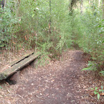
Continue straight: From the intersection, the walk follows the ‘Red Hands Cave’ sign down across the creek. The track leads over a small rise across another smaller creek, then follows the hillside for a short while, passing a bench seat and then a small log bridge. The track then starts tending left, heading up to a rocky outcrop where the walk arrives at the metal verandah of Red Hands Cave.
Continue straight: From the intersection, the walk heads across the small bridge and up the track. The walk soon passes over another small wooden bridge and then continues through the bush, with the creek on the right. Winding for a short time, the track comes to an un-signposted intersection.
Turn left: From the intersection, the walk heads up the hill, winding above the creek (on the right). The track follows the hillside for quite some time, passing near the creek in places, before coming to a ‘Glenbrook Causeway’ sign.
Continue straight: From the intersection, the walk follows the ‘Red Hands Cave’ sign down across the creek. The track leads over a small rise across another smaller creek, then follows the hillside for a short while, passing a bench seat and then a small log bridge. The track then starts tending left, heading up to a rocky outcrop where the walk arrives at the metal verandah of Red Hands Cave.
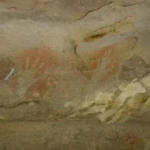
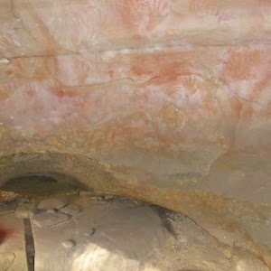
Red Hands Cave
Red Hands Cave, in the Glenbrook area of the Blue Mountains National Park, is found near the end of Red Hands Cave fire trail. The cave has quite a few hand stencils and prints of various colours (including red). The cave is well protected, with a perspex and steel cage. There are some information signs and some artifacts to help visitors learn more about the people who made these prints over 1600 years ago. In 1913, when searching for a lost child, this cave was found by Europeans and is now protected.
(3.21km) Red Hands Cave → Red Hands Cave car park
500 m
12 mins
41m
-10m
Moderate track
Continue straight: From Red Hands Cave, the walk heads up the stairs, winding to be above Red Hands Cave. The track then continues across the rocky surface, slowly climbing through the bush and leading away from the rock outcrop. The track winds through a few rocky outcrops, tending right, before coming to a car park and ‘Red Hands Cave’ sign (pointing back to the cave).
Red Hands Cave Picnic Area
Red Hands Cave Picnic Area is found at the end of the Red Hands Cave Fire Trail in the Glenbrook area of the Blue Mountains National Park. The small picnic area is next to the car park and has a couple of platforms (to act as both a table and seat) as well as a fire place and toilet. The toilet itself is wheelchair accessible, but access to the toilet is over moderately rough terrain. A good spot to rest when exploring Red Hands Cave.
(3.71km) Red Hands Cave car park → Axe Grinding Grooves
2.1 km
44 mins
42m
-161m
Moderate track
Turn left : From Red Hands Cave car park, the walk follows the sign for the ‘Link Track’ past the bench and fireplace and into the bush. The track winds down the hill via many steps, winding for quite some time, then comes near a creek, which it loosely follows. The walk then crosses this creek to the signposts on the other side.
Turn left: From the creek intersection, the walk follows the ‘Glenbrook Causeway’ sign, keeping the water on the left. The track continues up to a rock overhang from where it heads down the hill, coming near the creek again. The track follows the creek to a junction with another creek. To the left is a large sandstone area and approximately 10m along the track is a sign explaining the grooves in the sandstone.
Turn left: From the creek intersection, the walk follows the ‘Glenbrook Causeway’ sign, keeping the water on the left. The track continues up to a rock overhang from where it heads down the hill, coming near the creek again. The track follows the creek to a junction with another creek. To the left is a large sandstone area and approximately 10m along the track is a sign explaining the grooves in the sandstone.
Axe Grinding Grooves

These well-defined axe grinding groves are found on the sandstone bed of Camp Fire Creek. The grooves were formed by Aboriginal people when sharpening axes (or forming axe blanks). Rubbing the axe blanks would sharpen the stone into a more useful tool, and the process would also wear the sandstone, leaving these markings. These sites are typically found near water, as the water was added to make the stone more abrasive. Sites like this will fade in time due to erosion of the sandstone – please help them last as long as possible by not walking on, or close to the grooves. More info.
(5.8km) Axe Grinding Grooves → Campfire Creek car park
2.5 km
55 mins
108m
-93m
Hard track
Continue straight: From the grinding grooves at the creek junction, the walk heads across the side creek, keeping the larger creek on the left. The track immediately passes a sign with information about the grinding grooves, then continues above the creek. The track undulates above the creek and over a log bridge to tend right, down to a signposted intersection above a creek.
Turn right: From the intersection, the walk follows the ‘Glenbrook Causeway’ sign, across the hillside. The track keeps the creek on the left, and soon leads downhill. The track tends right as it winds down to an intersection with a track, which leads to a rock platform.
Turn right: From the intersection, the walk heads down the hill and away from the rocky outcrop. The track follows the creek (on the left) and soon crosses two small wooden bridges before coming to an intersection marked by a ‘Neighbours’ sign.
Continue straight: From the ‘Neighbours’ sign, the walk heads down the hill, keeping the sign and the creek on the left. The track meanders along the hillside for a short time before coming to a rock crossing at the creek. The track soon comes to a signposted intersection for the ‘Car park’ or ‘Red Hands Cave’.
Turn right: From the intersection, the walk follows the ‘Car park’ sign up the stairs. The track winds up the many stairs, then passes a sign and opens out at a hairpin turn in the road (The small flat area extended from the road is the car park).
Maps for the Red Hands Cave Circuit from Campfire Creek walk
You can download the PDF for this walk to print a map.
These maps below cover the walk and the wider area around the walk, they are worth carrying for safety reasons.
| Penrith | 1:25 000 Map Series | 90303N PENRITH | NSW-90303N |
| Penrith | 1:100 000 Map Series | 9030 PENRITH | 9030 |
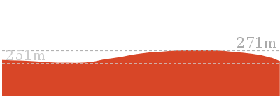
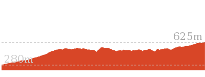
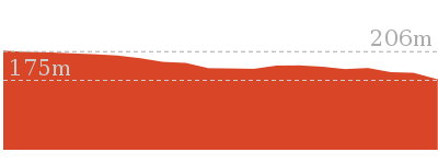
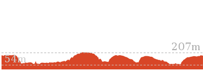
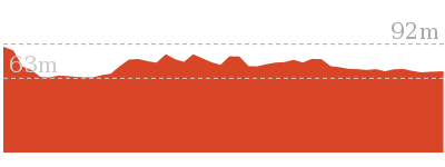
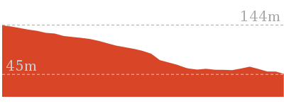
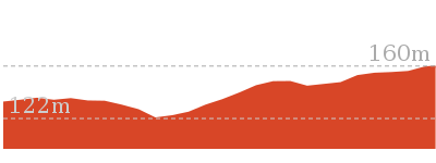
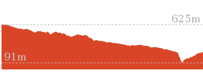
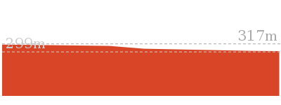
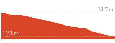
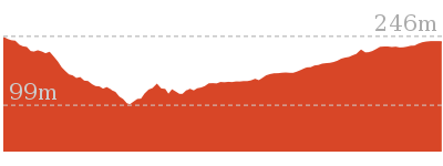
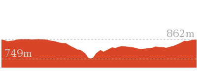
Cross sectional view of the Red Hands Cave Circuit from Campfire Creek bushwalking track
Analysis and summary of the altitude variation on the Red Hands Cave Circuit from Campfire Creek
Overview of this walks grade – based on the AS 2156.1 – 2001
Under this standard, a walk is graded based on the most difficult section of the walk.
| Length | 8.3 km | ||
| Time | 3 hrs 45 mins | ||
| . | |||
| Grade 4/6 Hard track |
AS 2156.1 | Gradient | Very steep (4/6) |
| Quality of track | Formed track, with some branches and other obstacles (3/6) | ||
| Signs | Directional signs along the way (3/6) | ||
| Experience Required | No experience required (1/6) | ||
| Weather | Weather generally has little impact on safety (1/6) | ||
| Infrastructure | Limited facilities, not all cliffs are fenced (3/6) |
Some more details of this walks Grading
Here is a bit more details explaining grading looking at sections of the walk
Gradient
6km of this walk has short steep hills and another 1.7km has gentle hills with occasional steps. The remaining (380m) is very steep.
Quality of track
This whole walk, 8km follows a formed track, with some branches and other obstacles.
Signs
Around 4.6km of this walk is clearly signposted, whilst the remaining 3.8km has directional signs at most intersection.
Experience Required
This whole walk, 8km requires no previous bushwalking experience.
weather
This whole walk, 8km is not usually affected by severe weather events (that would unexpectedly impact safety and navigation).
Infrastructure
Around 7km of this walk is close to useful facilities (such as fenced cliffs and seats), whilst the remaining 1.3km has limited facilities (such as not all cliffs fenced).
Similar walks
A list of walks that share part of the track with the Red Hands Cave Circuit from Campfire Creek walk.
1 km Return
30 mins
Moderate track
4.1 km Circuit
2 hrs
Moderate track
4.3 km One way
1 hr 45 mins
Experienced only
4.4 km One way
2 hrs
Hard track
8.4 km Circuit
3 hrs 45 mins
Experienced only
16.6 km Circuit
2 Days
Experienced only
18.8 km One way
2 Days
Very experienced only
Other Nearby walks
A list of walks that start near the Red Hands Cave Circuit from Campfire Creek walk.
218 m Return
20 mins
Moderate track
522 m Return
20 mins
Hard track
2.5 km Return
1 hr 15 mins
Hard track
1 km Return
45 mins
Moderate track
1.7 km Return
1 hr 30 mins
Hard track
512 m Return
30 mins
Hard track
74 m Return
10 mins
Very easy
2.8 km Circuit
1 hr 15 mins
Hard track
756 m Return
30 mins
Hard track
3.2 km Return
1 hr 30 mins
Hard track
1.4 km Return
1 Hr
Moderate track
2 km Circuit
1 Hr
Hard track
Plan your trip to and from the walk here
The Red Hands Cave Circuit from Campfire Creek walk starts and ends at the Campfire Creek car park (gps: -33.780202, 150.61726)
Your main transport option to Campfire Creek car park is by;
![]() Car. A park entry fee is required for driving into the park.
Car. A park entry fee is required for driving into the park.
(get details)
Short URL = http://wild.tl/rhccfcc
Gallery images
There are other downloads I am still working on.
You will probably need to login to access these — still all free.
* KML (google earth file)
* GPX (GPS file)
Special Maps/ brochures
* A3 topo maps
* PDF with Lands Topo map base
* PDF with arial image (and map overlay)
I wanted to get the main site live first, this extra stuff will come in time.
Happy walking
Matt 🙂
Red Hands Cave Circuit via Campfire Creek

3 hrs 45 mins
8.4 km Circuit
396 m
Experienced only
This is a scenic and rather cultural walk, with two significant Indigenous sites along the way. The walk sets out from Campfire Creek car park following the creek of similar name to the amazing Red Hands Caves. The second site is the grinding grooves, which are passed on the return to the car park along the ridge. A great walk with much to see.* This walk passes through very remote areas and sections have no visible track. At least one person in your group should have training and experience in off track walking and navigation. Even with these notes and a GPS these extra skills and equipment are required.


(0km) Campfire Creek car park → Int. Red Hands Cave and Carpark Trk
190 m
7 mins
0m
-42m
Hard track
From the car park, the track follows the ‘Campfire Creek’ sign down the hill. The track steeply descends the hill, winding to a ‘Car Park’ sign (pointing back the way you came).
(0.19km) Eastern side of Causeway → Int. Red Hands Cave and Carpark Trk
60 m
1 mins
3m
-1m
Moderate track
Turn left: From the paved area side of the causeway, the walk crosses the creek via the causeway, then heads to the area beneath the ‘Camp Fire Creek Track’ sign. The causeway may be impassable after rain.
Turn right: From the causeway, the walk follows the ‘Camp Fire Creek Track’ sign along the water’s edge to the signposts for ‘Red Hands Cave’ and ‘Car park’. Now Continue straight to join the main walk.
Turn right: From the causeway, the walk follows the ‘Camp Fire Creek Track’ sign along the water’s edge to the signposts for ‘Red Hands Cave’ and ‘Car park’. Now Continue straight to join the main walk.
(0.19km) Int. Red Hands Cave and Carpark Trk → Red Hands Cave
3 km
1 hr 11 mins
206m
-91m
Moderate track
Turn left: From the intersection, the walk follows the ‘Red Hands Cave’ sign, keeping the creek to the right. The track winds and undulates, soon coming to a rock platform which crosses a creek (with the gully on the left). Here, the walk continues along the lower track, not heading up the rock steps. The track continues along the hillside and comes to a sign titled ‘Neighbours’.
Continue straight: From the intersection, the walk heads across the small bridge and up the track. The walk soon passes over another small wooden bridge and then continues through the bush, with the creek on the right. Winding for a short time, the track comes to an un-signposted intersection.
Turn left: From the intersection, the walk heads up the hill, winding above the creek (on the right). The track follows the hillside for quite some time, passing near the creek in places, before coming to a ‘Glenbrook Causeway’ sign.
Continue straight: From the intersection, the walk follows the ‘Red Hands Cave’ sign down across the creek. The track leads over a small rise across another smaller creek, then follows the hillside for a short while, passing a bench seat and then a small log bridge. The track then starts tending left, heading up to a rocky outcrop where the walk arrives at the metal verandah of Red Hands Cave.
Red Hands Cave
Red Hands Cave, in the Glenbrook area of the Blue Mountains National Park, is found near the end of Red Hands Cave fire trail. The cave has quite a few hand stencils and prints of various colours (including red). The cave is well protected, with a perspex and steel cage. There are some information signs and some artifacts to help visitors learn more about the people who made these prints over 1600 years ago. In 1913, when searching for a lost child, this cave was found by Europeans and is now protected.
(3.21km) Red Hands Cave → Red Hands Cave car park
500 m
12 mins
41m
-10m
Moderate track
Continue straight: From Red Hands Cave, the walk heads up the stairs, winding to be above Red Hands Cave. The track then continues across the rocky surface, slowly climbing through the bush and leading away from the rock outcrop. The track winds through a few rocky outcrops, tending right, before coming to a car park and ‘Red Hands Cave’ sign (pointing back to the cave).
Red Hands Cave Picnic Area
Red Hands Cave Picnic Area is found at the end of the Red Hands Cave Fire Trail in the Glenbrook area of the Blue Mountains National Park. The small picnic area is next to the car park and has a couple of platforms (to act as both a table and seat) as well as a fire place and toilet. The toilet itself is wheelchair accessible, but access to the toilet is over moderately rough terrain. A good spot to rest when exploring Red Hands Cave.
(3.71km) Red Hands Cave car park → Axe Grinding Grooves
2.1 km
44 mins
42m
-161m
Moderate track
Turn left : From Red Hands Cave car park, the walk follows the sign for the ‘Link Track’ past the bench and fireplace and into the bush. The track winds down the hill via many steps, winding for quite some time, then comes near a creek, which it loosely follows. The walk then crosses this creek to the signposts on the other side.
Turn left: From the creek intersection, the walk follows the ‘Glenbrook Causeway’ sign, keeping the water on the left. The track continues up to a rock overhang from where it heads down the hill, coming near the creek again. The track follows the creek to a junction with another creek. To the left is a large sandstone area and approximately 10m along the track is a sign explaining the grooves in the sandstone.
Turn left: From the creek intersection, the walk follows the ‘Glenbrook Causeway’ sign, keeping the water on the left. The track continues up to a rock overhang from where it heads down the hill, coming near the creek again. The track follows the creek to a junction with another creek. To the left is a large sandstone area and approximately 10m along the track is a sign explaining the grooves in the sandstone.
Axe Grinding Grooves
These well-defined axe grinding groves are found on the sandstone bed of Camp Fire Creek. The grooves were formed by Aboriginal people when sharpening axes (or forming axe blanks). Rubbing the axe blanks would sharpen the stone into a more useful tool, and the process would also wear the sandstone, leaving these markings. These sites are typically found near water, as the water was added to make the stone more abrasive. Sites like this will fade in time due to erosion of the sandstone – please help them last as long as possible by not walking on, or close to the grooves. More info.
(5.8km) Axe Grinding Grooves → Campfire Creek car park
2.6 km
54 mins
107m
-89m
Experienced only
Turn sharp right: From where the main track crosses the small side creek (just above the axe grinding site), this walk follows the rocky side creek south-east, upstream. After about 20m, the gully splits in two. This walk follows a narrow track on the spur between these two creeks. The track heads up the spur line and crosses a number of rocky outcrops. Near the top of the hill, the bush becomes quiet dense. The track then opens out on the wide Oaks cycleway.
Turn left: From the intersection, this walk follows the wide track north as it bends to the right and heads down the hill into the more open forest. The track soon passes a blue ‘Shared use’ sign and comes to an intersection with a short but wide road access track.
Continue straight: From the intersection, the walk heads up the management trail, away from the road and the blue sign. The trail winds for a short time, follow a ‘Cycling Track’ sign down a track. The track winds down through the bush to an area where the track splits and then joins back together again. The walk then comes to a clearer area with access to the road on the right and a few log stumps in the clearing.
Veer left: From the log stumps in the intersection, the walk heads down the hill, keeping the road on the right. The track winds down to a very sandy section of track before heading up and across the hill. The track passes over a few rocky surfaces and passes a road-access track (on the right) before heading down the hill. The track is very rocky as it leads down to the hairpin corner in the road, where the car park is located. The track heads across the car park, keeping the road on the right, and arrives at the signpost.
Maps for the Red Hands Cave Circuit via Campfire Creek walk
You can download the PDF for this walk to print a map.
These maps below cover the walk and the wider area around the walk, they are worth carrying for safety reasons.
| Penrith | 1:25 000 Map Series | 90303N PENRITH | NSW-90303N |
| Penrith | 1:100 000 Map Series | 9030 PENRITH | 9030 |
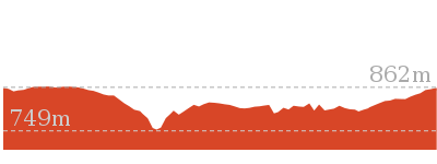
Cross sectional view of the Red Hands Cave Circuit via Campfire Creek bushwalking track
Analysis and summary of the altitude variation on the Red Hands Cave Circuit via Campfire Creek
Overview of this walks grade – based on the AS 2156.1 – 2001
Under this standard, a walk is graded based on the most difficult section of the walk.
| Length | 8.4 km | ||
| Time | 3 hrs 45 mins | ||
| . | |||
| Grade 5/6 Experienced only |
AS 2156.1 | Gradient | Very steep (4/6) |
| Quality of track | Rough track, where fallen trees and other obstacles are likely (4/6) | ||
| Signs | No directional signs (5/6) | ||
| Experience Required | Moderate level of bushwalking experience recommended (4/6) | ||
| Weather | Storms may impact on navigation and safety (3/6) | ||
| Infrastructure | No facilities provided (5/6) |
Some more details of this walks Grading
Here is a bit more details explaining grading looking at sections of the walk
Gradient
6km of this walk has short steep hills and another 1.8km has gentle hills with occasional steps. The remaining (900m) is very steep.
Quality of track
8km of this walk follows a formed track, with some branches and other obstacles and another 710m follows a rough track, where fallen trees and other obstacles are likely. The remaining (190m) follows a clear and well formed track or trail.
Signs
4.8km of this walk has directional signs at most intersection and another 2.9km is clearly signposted. The remaining (710m) Has no directional signs.
Experience Required
Around 8km of this walk requires no previous bushwalking experience, whilst the remaining 710m requires a leader a with moderate level of bushwalking experience.
weather
Around 8km of this walk is not usually affected by severe weather events (that would unexpectedly impact safety and navigation), whilst the remaining 710m is affected by storms that may impact your navigation and safety.
Infrastructure
5km of this walk is close to useful facilities (such as fenced cliffs and seats) and another 2.4km has limited facilities (such as not all cliffs fenced). The remaining (710m) has no facilities provided.
Similar walks
A list of walks that share part of the track with the Red Hands Cave Circuit via Campfire Creek walk.
1 km Return
30 mins
Moderate track
4.1 km Circuit
2 hrs
Moderate track
4.3 km One way
1 hr 45 mins
Experienced only
4.4 km One way
2 hrs
Hard track
8.3 km Circuit
3 hrs 45 mins
Hard track
16.6 km Circuit
2 Days
Experienced only
18.8 km One way
2 Days
Very experienced only
29.6 km One way
3 Days
Hard track
Other Nearby walks
A list of walks that start near the Red Hands Cave Circuit via Campfire Creek walk.
218 m Return
20 mins
Moderate track
522 m Return
20 mins
Hard track
2.5 km Return
1 hr 15 mins
Hard track
1 km Return
45 mins
Moderate track
1.7 km Return
1 hr 30 mins
Hard track
512 m Return
30 mins
Hard track
74 m Return
10 mins
Very easy
2.8 km Circuit
1 hr 15 mins
Hard track
756 m Return
30 mins
Hard track
3.2 km Return
1 hr 30 mins
Hard track
1.4 km Return
1 Hr
Moderate track
2 km Circuit
1 Hr
Hard track
Plan your trip to and from the walk here
The Red Hands Cave Circuit via Campfire Creek walk starts and ends at the Campfire Creek car park (gps: -33.780202, 150.61726)
Your main transport option to Campfire Creek car park is by;
![]() Car. A park entry fee is required for driving into the park.
Car. A park entry fee is required for driving into the park.
(get details)
Short URL = http://wild.tl/rhcxx
Gallery images
There are other downloads I am still working on.
You will probably need to login to access these — still all free.
* KML (google earth file)
* GPX (GPS file)
Special Maps/ brochures
* A3 topo maps
* PDF with Lands Topo map base
* PDF with arial image (and map overlay)
I wanted to get the main site live first, this extra stuff will come in time.
Happy walking
Matt 🙂
Woodford Station to cliff lookout
And Walk
Woodford Station to cliff lookout

3 hrs 30 mins
8.6 km Return
346 m
Hard track


(0km) Woodford Station → Int. Oaks Firetrail and Old Bathurst Rd
730 m
15 mins
22m
-39m
Easy track
From the station, this walk heads down the stairs, off the station and turns left under the station. It then continues up to Railway Parade, opposite a shelter with a bench seat. The walk heads up Railway Pde, keeping the railway tracks to the left. The road tends right then the walk turns right onto The Appian Way. The walk follows The Appian Way, which turns into Parker St. (If you cross over a bridge, you have gone the wrong way.) The walk leads along Parker St to Taylor St, where it turns left and continues down the hill to the intersection with The Oaks Fire Trail. This is signposted at the clearing on the right.
(0.73km) Int. Oaks Firetrail and Old Bathurst Rd → Int. Oaks Firetrail and cliff lookout Trk
3.5 km
1 hr 10 mins
87m
-175m
Moderate track
Turn right: From the road, the walk heads to the gate and crosses over it. (On the lower side of the gate is a tap which provides drinking water.) From the gate and tap, the walk heads down the hill, passing a broken interpretative sign on the left, and continues to wind and undulate for quite some time. The trail passes a mound in a junction. From the mound, the trail continues to wind and undulate, turning right and steeply downhill twice, before passing a small dam (just to the left). The walk winds, with the hillside higher on the right than left, before leading up a steep slope to a small clearing with a large step.
(4.21km) Int. Oaks Firetrail and cliff lookout Trk → Cliff lookout
100 m
3 mins
5m
-18m
Hard track
Turn right: From the intersection, the walk heads away from the management trail, with the small depression (or waterhole) on the left, surrounded by reeds. The track winds up the hill, following the gap in the vegetation, leading to a rock shelf with a view.
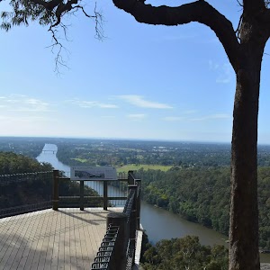
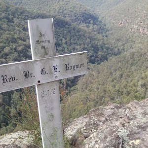
Cliff Lookout
Cliff lookout, an unofficially-named, informal view point, is a dramatic cliff edge perched just above the trees. The cliff is unfenced. The view across the valley provides a pleasant panorama.
Maps for the Woodford Station to cliff lookout walk
You can download the PDF for this walk to print a map.
These maps below cover the walk and the wider area around the walk, they are worth carrying for safety reasons.
| Springwood | 1:25 000 Map Series | 90304S SPRINGWOOD | NSW-90304S |
| Penrith | 1:25 000 Map Series | 90303N PENRITH | NSW-90303N |
| Jamison | 1:25 000 Map Series | 89302N JAMISON | NSW-89302N |
| Katoomba | 1:25 000 Map Series | 89301S KATOOMBA | NSW-89301S |
| Penrith | 1:100 000 Map Series | 9030 PENRITH | 9030 |
| Katoomba | 1:100 000 Map Series | 8930 KATOOMBA | 8930 |
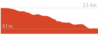
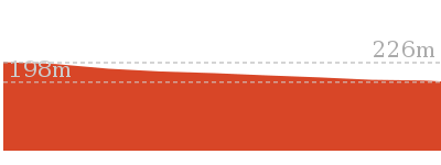
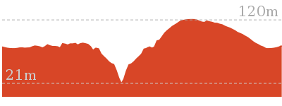
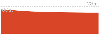
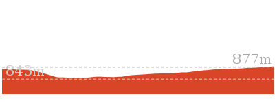
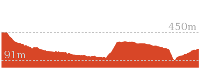
Cross sectional view of the Woodford Station to cliff lookout bushwalking track
Analysis and summary of the altitude variation on the Woodford Station to cliff lookout
Overview of this walks grade – based on the AS 2156.1 – 2001
Under this standard, a walk is graded based on the most difficult section of the walk.
| Length | 8.6 km | ||
| Time | 3 hrs 30 mins | ||
| . | |||
| Grade 4/6 Hard track |
AS 2156.1 | Gradient | Short steep hills (3/6) |
| Quality of track | Rough track, where fallen trees and other obstacles are likely (4/6) | ||
| Signs | Minimal directional signs (4/6) | ||
| Experience Required | No experience required (1/6) | ||
| Weather | Weather generally has little impact on safety (1/6) | ||
| Infrastructure | Limited facilities (such as cliffs not fenced, significant creeks not bridged) (4/6) |
Some more details of this walks Grading
Here is a bit more details explaining grading looking at sections of the walk
Gradient
Around 3.6km of this walk has short steep hills, whilst the remaining 730m has gentle hills with occasional steps.
Quality of track
3.5km of this walk follows a formed track, with some branches and other obstacles and another 730m follows a smooth and hardened path. The remaining (95m) follows a rough track, where fallen trees and other obstacles are likely.
Signs
3.5km of this walk has directional signs at most intersection and another 730m is clearly signposted. The remaining (95m) has minimal directional signs.
Experience Required
This whole walk, 4.3km requires no previous bushwalking experience.
weather
This whole walk, 4.3km is not usually affected by severe weather events (that would unexpectedly impact safety and navigation).
Infrastructure
3.5km of this walk has limited facilities (such as not all cliffs fenced) and another 730m is close to useful facilities (such as fenced cliffs and seats). The remaining (95m) has limited facilities (such as cliffs not fenced, significant creeks not bridged).
Similar walks
A list of walks that share part of the track with the Woodford Station to cliff lookout walk.

15.9 km One way
7 hrs
Experienced only
18.1 km One way
7 hrs
Hard track
18.3 km One way
7 hrs 15 mins
Experienced only
23.4 km One way
2 Days
Experienced only
29.6 km One way
3 Days
Hard track
Other Nearby walks
A list of walks that start near the Woodford Station to cliff lookout walk.
180 m Return
15 mins
Moderate track
3.1 km Return
3 hrs 30 mins
Experienced only
1.2 km Return
1 hr 30 mins
Hard track
5.4 km Return
3 hrs 30 mins
Experienced only
1.6 km One way
45 mins
Easy track
2.6 km Circuit
1 hr 30 mins
Hard track
2.9 km One way
2 hrs
Hard track
1.3 km Return
1 Hr
Moderate track
1.7 km Circuit
1 Hr
Hard track

2.2 km Circuit
1 hr 30 mins
Hard track
2 km Circuit
1 hr 30 mins
Moderate track
15.2 km One way
2 Days
Experienced only
Plan your trip to and from the walk here
The Woodford Station to cliff lookout walk starts and ends at the Woodford Station (gps: -33.735763, 150.48228)
Your transport options to Woodford Station are by;
![]() Train. (get details)
Train. (get details)
![]() Bus. (get details)
Bus. (get details)
![]() Car. There is free parking available.
Car. There is free parking available.
(get details)
Short URL = http://wild.tl/wstcl
Gallery images
There are other downloads I am still working on.
You will probably need to login to access these — still all free.
* KML (google earth file)
* GPX (GPS file)
Special Maps/ brochures
* A3 topo maps
* PDF with Lands Topo map base
* PDF with arial image (and map overlay)
I wanted to get the main site live first, this extra stuff will come in time.
Happy walking
Matt 🙂
Dadder Cave and Jack Evans track
And Walk
Dadder Cave and Jack Evans track

2 Days
10.3 km Circuit
535 m
Very experienced only
This fairly short overnight walk is a great way to explore Erskine Creek. The walking along Erskine creek is mostly off track, and is through thick scrub in places. Although this walk could be done in a day, an overnight walk gives more time to explore the creek and enjoy the caves in the area. * This walk passes through very remote areas and sections have no visible track. At least one person in your group should have training and experience in off track walking and navigation. Even with these notes and a GPS these extra skills and equipment are required.


(0km) Pisgah Rock track head → Pisgah Rock Intersection
760 m
14 mins
21m
-17m
Moderate track
From the Pisgah Rock car park (2.2km further along Nepean Lookout Fire Trail from the Oaks Picnic Area), this walk follows the ‘Pisgah Rock 700mt’ sign along the old management trail. The track meanders through the Eucalypt and Casuarina forest as it climbs a gentle hill and then heads down the other side. The track soon comes to an intersection with a small bush track off to the left, from the intersection there are glimpses of the valley views.
(0.76km) Pisgah Rock Intersection → Attic Cave
250 m
6 mins
13m
-23m
Experienced only
Turn right: From the intersection, the walk follows the old management trail that very soon narrows into a bush track as it heads away from the view (keeping the valley to the left). The tracks then emerges from the bush to cut across a rock shelf and into the scrub again. Once in the gully the track turns left to climb down the ‘V’ in the rock. At the bottom of the climb the walk heads right under the now obvious sandstone cave. The walk continues following the base of this cliff line along a fairly clear track passing several interesting sandstone overhangs. Soon the track comes to a large overhang and fire circle at Attic camping cave. At the end of this side trip, retrace your steps back to the main walk then Veer right.
Attic Cave
Attic Cave, near Pisgah Rock in the lower blue mountains is a large sandstone overhang. The cave has been used by walkers as an overnight camp for many decades. The cave could comfortably sleep about 5 people. There is a log book in a tin cake box on the rock shelf, making for some interesting reading, and awaiting your story. There is a fire circle, and the cave is reasonably well protected from the weather. The name Attic Cave is said to have come from the hole, a shelf, in the top of the cave, forming an attic.
(0.76km) Pisgah Rock Intersection → Pisgah Rock
20 m
1 mins
0m
-5m
Moderate track
Veer left: From the intersection this walk takes the short bush track toward the view of the valley. The track comes to the unfenced cliff and great view from the top of Pisgah Rock and a sign posted ‘take care when walking near cliffs’.
Pisgah Rock
Pisgah Rock, is a short walk from Nepean Lookout Fire Trail in the lower Blue Mountains, and provides excellent views up Erskine Creek Gorge. The informal lookout is not fenced, and the surface is uneven with large crevasse like cracks. The view is simply amazing, with great views right up the middle of Erskine Creek Gorge. There are also great views to the left, down Erskine Creek Gorge and across the flats of the southern parts for greater Sydney. The rock presumably derives its name from the height point on Mount Nebo, where the Bible reports Moses seeing the promised land for the first time. In Hebrew pisgah refers to a high place. This Pisgah Rock is very much a high place, with great views.
(0.78km) Pisgah Rock → Junction of Erskine and Lincoln Crks
610 m
21 mins
18m
-200m
Very experienced only
Turn right: From the ‘take care when walking near cliffs’ signpost on Pisgah Rock this walk now follows the rock at the top of the cliff keeping the valley below to the left. After passing a couple of very steep looking cracks in the rock, the faint track comes to a much more gentle looking pass with a large Banksia growing out of it. The walk heads down through this pass. The track turns right and heads down a much steeper climb through the V in the rock. At the bottom of this climb the bush track leads to a small unfenced rock platform. The walk then turns right heading down the couple more climbs then turns left back under the rock platform. The track continues to wind down several more steep rocky climbs following a faint track and cairns. after most climbs the track generally tends left and down hill. After the last climb, the track heads away from the cliff making, tending left heading fairly steeply to an intersection near the junction of Erskine Creek and Lincoln Creek.
Junction of Erskine and Lincoln Creeks
The junction of Erskine and Lincoln Creeks, in the Blue Mountains National park, occurs at a large rock platform. The rock platform contains many water holes, a few large square boulders and a few short cascades. There are breath taking views up looking Erskine Creek Gorge. Looking up to the escarpment, to the north east, there is a view of Pisgah Rock. This area floods after rain, but when water levels are normal, this can be a lovely place to rest and enjoy the creeks and gorge.
(1.38km) Junction of Erskine and Lincoln Creeks → Lower Lincoln Campsite
70 m
2 mins
3m
-4m
Experienced only
Turn right: From the intersection, this walk cross Lincoln Creek at the rock pools staying upstream of the small cascade (this may be impassable after rain). On the other side of the creek the walk picks up a faint track heading gently up the ridge. Soon the track opens up into a large campsite with some wonderful grass trees.
Lower Lincoln Campsite
This well established campsite is found about 60m up the spur, south west of the junction of Lincoln and Erskine Creek. The large campsite has enough room for 6-10 tents and has an established campfire with log seats. The campsite is set among some lovely eucalypt and grass trees. Water from both creeks should be treated before drinking. If this campsite is full, there are a few alternative smaller sites in the area, one further up the hill, and another down by Erskine Creek.
(1.46km) Lower Lincoln Campsite → Dadder Cave
1.5 km
32 mins
67m
-40m
Very experienced only
Turn left: From the eastern side of the campsite this walk follows the narrow track towards Erskine Creek. Just before the creek the track turns right and heads up stream. The track soon fades and becomes undefined, this walk continues along the flood bank to find a good spot to cross to the other side of Erskine Creek. There are a few cossing options before coming to the land slide, feet will most likely get wet (the creek may be impassable after rain). When crossing notice the rounded hill upstream, Dadder cave is about 1km before it. One on the eastern bank the walk continues upstream heading towards the rounded hill with Erskine creek now to the right. The walk passes several smaller caves and as the walk gets closer to Dadder Cave a fairly well defined track forms leading up behind a large boulder and into the cave. The cave is just upstream from, and on the opposite side of the gorge, from a gully entering Erskine Creek from the west. The cave has clearly been used for camping for some time, with a campfire, and left over camping material.
Dadder Cave
Dadder cave, is a large sandstone cave, that has been used as a camping cave by bushwalkers for several decades. The cave is on the easter side of Erskine Creek, about 1.5km upstream from the junction with Lincoln Creek. The large cave is about 30m up the bank and fairly well protected from the weather. There is enough room to sleep about 6 people, more if people are comfortable with each other, and happy to spread along the full length of the cave. A large stone fire place, a bench seat, and a few other items have been left by previous walkers. A log book that makes interesting reading is found under a tarp at the high end of the cave. The cave make a great base camp, for walkers planning to spend some time enjoying Erskine Creek. The name ‘Dadder’ is believed to come from Death Adder, abbreviated to D’adder, and then finally to Dadder. Erskine Creek provides plenty of water, treat the water before drinking.
End of day 1
This is the planned overnight stay for the end of day 1, happy camping.
(3km) Dadder Cave → Junction of Erskine and Lincoln Creeks
1.6 km
34 mins
44m
-70m
Very experienced only
Turn around: From Dadder cave this walk heads out the high end of the cave picking up, and following a track from the gum tree. The creek can be heard below and to the left, as the track heads around the large boulder on the uphill side. The track soon fades to a foot pad, and is not visible at times, but the walk continues following the creek downstream. The clearest route often takes the walker higher up the bank and across rock platforms and around boulders. The creek is not always clearly visible. The walk keeps the creek on the left until finding a good place to cross after passing the land slide on the oppersite bank (this creek may be impassable after rain). Once on the western bank the walk follows the flood bank, through the dense scrub. Before to long a faint track appears and becomes clearer as it leads down stream. About 50m before the junction with Lincoln Creek, the track turns left up away from the creek. Following this track left, leads up short hill to a large open campsite.
Turn right: From the campsite, this walk takes the track from the lowest point in the campsite near the grass tress and heads down the hill. The track soon open up onto the rock pools on Lincoln Creek a few meters above Erskine Creek. The walk crosses Lincoln Creek upstream of the small cascade to find a track on the opperite bank near the large boulder (this may be impassable after rain).
Turn right: From the campsite, this walk takes the track from the lowest point in the campsite near the grass tress and heads down the hill. The track soon open up onto the rock pools on Lincoln Creek a few meters above Erskine Creek. The walk crosses Lincoln Creek upstream of the small cascade to find a track on the opperite bank near the large boulder (this may be impassable after rain).
(4.61km) Junction of Erskine and Lincoln Creeks → Rock platform
260 m
7 mins
22m
-13m
Experienced only
Veer right: From the intersection, this walk head downstream along Erskine Creek, keeping the creek to the right. After following the indistinct bush track for a short while it leads to an large open rock platform. The walk continues along the rock until coming to the edge of a large pool at the bottom of the cascades.
Rock Platform
This is a rock platform on Erskine creek about 200m downstream from the junction with Lincoln Creek. The area does flood so depending on water levels this is usually a large rock platform with some interesting water holes, and a lovely cascade flowing into a shallow pool. Although this lacks the majestic view up Erskine Creek (found a short distance upstream), this spot does provide an open spot, great for a snack, lunch and to rest.
(4.87km) Rock platform → Lower Erskine Campsite
2.3 km
51 mins
98m
-141m
Very experienced only
Veer left: From the end of the rock platform, the walk heads downstream initially by following the rock fall on the northern bank. There is a faint foot pad that lasts a short while. Find a good place to cross to the other bank (may be impassable after rain), where a rock shelf on the southern bank make walking easier. After passing the large gully the foot pad has all but disappeared, the walk continues down stream keeping the creek on the left. About half way along the large cliff high on the other side of the creek, the bank on the western side becomes difficult to pass due to another cliff. From here find a good place to cross (may be impassable after rain) and pick up the faint foot pad on the other side. The foot pad continues downstream (now with the creek on the right) and passes a few rock platforms at times. The track becomes more distinct as it gets closer to Jack Evans track. Not far before Jack Evans track the footpad comes to a small campsite with a fire circle on the left.
Lower Erskine Campsite
A small campsite, just up from the eastern bank of Erskine Creek, a short distance north of where Jack Evans track crosses the creek. The campsite has a small fire circle, and enough space for one maybe two tents. Erskine creek is a handy water supply (treat before drinking).
(7.14km) Lower Erskine Campsite → Int of Jack Evans Track and Erskine Creek
110 m
2 mins
4m
-2m
Experienced only
Continue straight: From the campsite this walk heads down stream keeping the creek to the right. Following a faint bush track the walk soon comes to an intersection with the Jack Evans Track just above a small sandy beach.
(7.25km) Int of Jack Evans Track and Erskine Creek → Int of Jack Evans and the lower Erskine tracks
100 m
2 mins
6m
-5m
Experienced only
Turn left: From the intersection just above sandy beach on the creek, this walk follows the clear bush track away from the creek and up the gentle hill. The track soon turns right and follows the creek on the right, downstream for a little while. The track then tends left up hill passing through a tunnel of vegetation to emerge onto an intersection with the more distinct Jack Evans and lower Erskine tracks
(7.35km) Int of Jack Evans and the lower Erskine tracks → Eastern side of natural dam wall
180 m
7 mins
30m
-17m
Experienced only
Turn right: From the intersection, this walk follows the wider bush track down hill keeping the sound of Erskine Creek to the right, soon the creek is in view. The track soon fades to a become a less distinct bush track leading up the bank away from the creek. The track climbs to a large boulder providing great views of the pool in Erskine Creek. The track then leads down to the natural charcoal deposits and continues along the creek edge to the water depth indicators. (A remote monitoring box is visible up the hill).
Veer left: From the water depth indicators this walk follows the creek down stream keeping Erskine Creek on the right. The faint bush track soon leads to the visible series of large boulders forming a natural dam wall. At the end of this side trip, retrace your steps back to the main walk then Veer right.
Veer left: From the water depth indicators this walk follows the creek down stream keeping Erskine Creek on the right. The faint bush track soon leads to the visible series of large boulders forming a natural dam wall. At the end of this side trip, retrace your steps back to the main walk then Veer right.
Natural dam pool
A series of very large boulders have formed a natural dam on Erskine Creek, about 170m north of Big Crater Creek. The dam forms a large lovely pool upstream. The pool is used by Sydney Water for measurements, and a water depth indicator is bolted to the rock. The pools is not safe to dive or jump into, there are many submerged objects.
(7.35km) Int of Jack Evans and the lower Erskine tracks → Erskine Lookout
850 m
31 mins
172m
-28m
Hard track
Veer left: From the intersection this walk follows the wider bush track up the hill past the large gum tree. The track then comes to, and climbs a series of timber steps up to a distinct saddle. The track continues gently up the hill for a short distance to come to an intersection with the faint short cut track off to the right.
Continue straight: From the intersection this walk follows the wider bush track up the gentle hill. The track is narrow in places with a drop off to the right. The track then starts to climb the hill using a series of steps and switch backs to wind up through the wonderful sandstone outcrops. The track passes a few nice caves and through gaps in the rock. After the last steep section the track comes to a large rock platform on the left (with some great views). The track continues to follow the main path up the hill, and passes a long sandstone wall on the left of the track. Soon after this sandstone wall, the track comes to a wide sandy patch, with and unfenced rock platform and view on the left. This is the Erskine Lookout, an informal unfenced lookout.
Continue straight: From the intersection this walk follows the wider bush track up the gentle hill. The track is narrow in places with a drop off to the right. The track then starts to climb the hill using a series of steps and switch backs to wind up through the wonderful sandstone outcrops. The track passes a few nice caves and through gaps in the rock. After the last steep section the track comes to a large rock platform on the left (with some great views). The track continues to follow the main path up the hill, and passes a long sandstone wall on the left of the track. Soon after this sandstone wall, the track comes to a wide sandy patch, with and unfenced rock platform and view on the left. This is the Erskine Lookout, an informal unfenced lookout.
Erskine Lookout
This informal and unfenced lookout on Jack Evans Track is in the lower Blue Mountains south west from the end of Nepean Lookout Fire Trail. The lookout is perched high above Erskine Creek and provides wonderful view upstream, and good views downstream. The view down in to the gorge gives a unique perspective of the lower section of Erskine Creek.
(8.2km) Erskine Lookout → End of Nepean Lookout Fire Trail
320 m
8 mins
29m
-1m
Moderate track
Continue straight: From Erskine Lookout, this walk heads up the gentle hill, following the sandy track, keeping the view to the left. The track passes some informal tracks to the left, passes a burnt ‘take care when walking near cliffs’ sign, and continues up the hill getting a little steeper. The track then comes to a silver information sign about ‘Jack Evans Track’. The track then bends left and comes to the car park at the end of the publicly accessible section of the Nepean Lookout Fire Trail.
(8.52km) Car park at end of Nepean Lookout fire trail → Pisgah Rock track head
1.8 km
33 mins
51m
-9m
Easy track
Turn left: From the end of end of Nepean Lookout fire trail, this walk follows the road northward away from the locked gate initially keeping the car park to the left. The road soon comes to an intersection with Pisgah Ridge fire trail (a gated management trail on the right).
Veer left: From the intersection, this walk follows Nepean Lookout fire trail north west around the left hand bend. The road soon comes to the Machins Crater car park.
Continue straight: From the Machins Crater car park, this walk follows Nepean Lookout fire trail north west, up the hill, initially with Machins Crater track on the left. The road heads up the hill and soon comes the Pisgah Rock track head and car park.
Veer left: From the intersection, this walk follows Nepean Lookout fire trail north west around the left hand bend. The road soon comes to the Machins Crater car park.
Continue straight: From the Machins Crater car park, this walk follows Nepean Lookout fire trail north west, up the hill, initially with Machins Crater track on the left. The road heads up the hill and soon comes the Pisgah Rock track head and car park.
Maps for the Dadder Cave and Jack Evans track walk
You can download the PDF for this walk to print a map.
These maps below cover the walk and the wider area around the walk, they are worth carrying for safety reasons.
| Penrith | 1:25 000 Map Series | 90303N PENRITH | NSW-90303N |
| Penrith | 1:100 000 Map Series | 9030 PENRITH | 9030 |
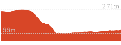
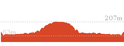
Cross sectional view of the Dadder Cave and Jack Evans track bushwalking track
Analysis and summary of the altitude variation on the Dadder Cave and Jack Evans track
Daily actual walking time estimates
| Day | Walking Time | Length |
|---|---|---|
| 1 | 1 hr 16 mins | 3.2 km |
| 2 | 2 hrs 55 mins | 7.5 km |
Overview of this walks grade – based on the AS 2156.1 – 2001
Under this standard, a walk is graded based on the most difficult section of the walk.
| Length | 10.3 km | ||
| Time | 2 Days | ||
| . | |||
| Grade 6/6 Very experienced only |
AS 2156.1 | Gradient | Very steep and difficult scrambles (5/6) |
| Quality of track | Off track (no visible track at times) (6/6) | ||
| Signs | No directional signs (5/6) | ||
| Experience Required | Very high level of bushwalking experience recommended (6/6) | ||
| Weather | Forecast, unforecast storms and severe weather may impact on navigation and safety (4/6) | ||
| Infrastructure | No facilities provided (5/6) |
Some more details of this walks Grading
Here is a bit more details explaining grading looking at sections of the walk
Gradient
3.7km of this walk is very steep with difficult rock scrambles and another 3.1km is very steep. Whilst another 2.7km has gentle hills with occasional steps and the remaining 790m has short steep hills.
Quality of track
5km of this walk follows a known route where there is no visible track and another 2.4km follows a smooth and hardened path. Whilst another 1.4km follows a formed track, with some branches and other obstacles and a 760m section follows a clear and well formed track or trail. The remaining 410m follows a rough track, where fallen trees and other obstacles are likely.
Signs
7km of this walk Has no directional signs and another 1.8km is clearly signposted. Whilst another 1.1km has directional signs at most intersection and the remaining 850m has minimal directional signs.
Experience Required
5km of this walk requires a leader with a high level of bushwalking experience and another 2.6km requires no previous bushwalking experience. Whilst another 1.1km requires some bushwalking experience and a 720m section requires a leader a with moderate level of bushwalking experience. The remaining 610m requires at least one leader with a very high level of bushwalking experience.
weather
5km of this walk is affected by forecast, unforecast storms and severe weather events that may impact on navigation and safety and another 3.8km is not usually affected by severe weather events (that would unexpectedly impact safety and navigation). The remaining (1.1km) is affected by storms that may impact your navigation and safety.
Infrastructure
6km of this walk has no facilities provided and another 1.8km is close to useful facilities (such as fenced cliffs and seats). Whilst another 1.7km has limited facilities (such as not all cliffs fenced) and the remaining 420m has limited facilities (such as cliffs not fenced, significant creeks not bridged).
Similar walks
A list of walks that share part of the track with the Dadder Cave and Jack Evans track walk.
648 m Return
20 mins
Moderate track
1.6 km Return
45 mins
Moderate track
2 km Return
1 Hr
Experienced only
2.6 km Return
2 hrs
Experienced only
2.8 km Return
3 hrs
Very experienced only
6 km Return
4 hrs
Very experienced only
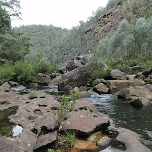
7.1 km Circuit
4 hrs 30 mins
Very experienced only
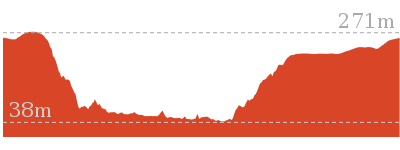
Other Nearby walks
A list of walks that start near the Dadder Cave and Jack Evans track walk.
466 m Return
15 mins
Moderate track
1.3 km Return
30 mins
Moderate track
18.1 km One way
7 hrs
Hard track
4.3 km One way
1 hr 45 mins
Experienced only
2.8 km Circuit
1 hr 15 mins
Hard track
4.1 km Circuit
2 hrs
Moderate track
1 km Return
30 mins
Moderate track
512 m Return
30 mins
Hard track
8.3 km Circuit
3 hrs 45 mins
Hard track
8.4 km Circuit
3 hrs 45 mins
Experienced only
218 m Return
20 mins
Moderate track
522 m Return
20 mins
Hard track
Plan your trip to and from the walk here
The Dadder Cave and Jack Evans track walk starts and ends at the Pisgah Rock track head (gps: -33.828459, 150.5717)
Your main transport option to Pisgah Rock track head is by;
![]() Car. A park entry fee is required for driving into the park.
Car. A park entry fee is required for driving into the park.
(get details)
Short URL = http://wild.tl/dcajet
Gallery images
There are other downloads I am still working on.
You will probably need to login to access these — still all free.
* KML (google earth file)
* GPX (GPS file)
Special Maps/ brochures
* A3 topo maps
* PDF with Lands Topo map base
* PDF with arial image (and map overlay)
I wanted to get the main site live first, this extra stuff will come in time.
Happy walking
Matt 🙂
Martin’s Lookout to Woodford Station
And Walk
Martin’s Lookout to Woodford Station

7 hrs
15.9 km One way
892 m
Experienced only
A long day walk, with a few solid hills to start, and some great views. The walk follows the St Helena Ridge, after crossing the Glenbrook Creek, then continues along The Oaks Fire Trail to Woodford Station. The the last part of the walk follows a management trail with plenty of wild flowers at the right time of year.* This walk passes through very remote areas and sections have no visible track. At least one person in your group should have training and experience in off track walking and navigation. Even with these notes and a GPS these extra skills and equipment are required.

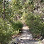
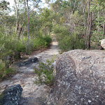
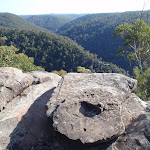


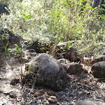
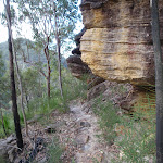
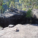
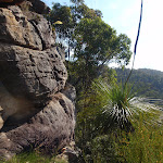
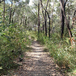

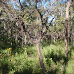

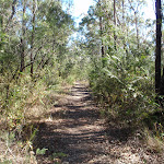
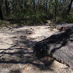

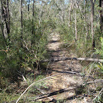
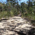
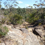
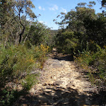
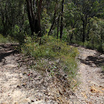

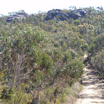

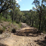


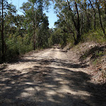

(0km) Int. Martins Lookout and Short Trks → Martins Lookout Carpark
60 m
2 mins
12m
0m
Easy track
From the intersection, the walk heads up the stairs around a rocky outcrop and continues through the low scrub, to the cable rimmed car park.
(0.09km) Martins Lookout → Bunyan Lookout
1.5 km
1 hr 4 mins
224m
-205m
Experienced only
Turn right: From Martins Lookout, the track heads south-east around the rocky knoll, with the views to the right of the track. The track quickly comes off the sandstone surface and descends stairs which zigzag under the cliffs. The walk passes under many overhangs, some of which overhang the track as it makes its way down the hillside. Tightly winding its way down the hill, the track descends a final flight of stairs to the signposted intersection.
Turn left: From the intersection, the walk follows the ‘Bunyan Lkt’ post down the stairs. The walk soon meets the creek and turns left, following the creek for a short distance before crossing at an opening in the shrubs around the creek. From here, the walk follows the cairns (rock stacks) across creek flats before climbing the hill to the base of a small cliff line. At one point beneath the cliff line, the walk ducks through a hole in the rock, then winds up through boulders, following more cairns. The walk continues up the hill, passing through a few more rocky outcrops to reach the informal, unfenced Bunyan Lookout, in a clearing near the cliff line.
Turn left: From the intersection, the walk follows the ‘Bunyan Lkt’ post down the stairs. The walk soon meets the creek and turns left, following the creek for a short distance before crossing at an opening in the shrubs around the creek. From here, the walk follows the cairns (rock stacks) across creek flats before climbing the hill to the base of a small cliff line. At one point beneath the cliff line, the walk ducks through a hole in the rock, then winds up through boulders, following more cairns. The walk continues up the hill, passing through a few more rocky outcrops to reach the informal, unfenced Bunyan Lookout, in a clearing near the cliff line.
Bunyan Lookout
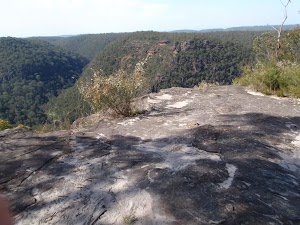
Bunyan Lookout is an large, unfenced sandstone platform overlooking the Glenbrook Creek valley. Behind the lookout, there is a small sandy clearing, big enough for a few tents. The lookout spans across Glenbrook Creek and sandstone cliffs of the valley.
(1.57km) Bunyan Lookout → Int. Bunyan Lookout Trk and Lost Worlds Trk
570 m
10 mins
18m
-7m
Moderate track
Turn sharp right: From Bunyan Lookout, the walk heads back into the clearing behind the unfenced cliff line and turns left at the cairn (if you head down into the valley, you have gone the wrong way). The walk meanders through the heath for a short time before coming to a red painted stump, on the right of the track.
(2.14km) Int. Bunyan Lookout Trk and Lost Worlds Trk → Lost Worlds Lookout
570 m
11 mins
20m
-13m
Moderate track
Turn right: From the red stump intersection, the walk follows the ‘Lost Worlds’ sign up the small hill. The walk winds through the bush for a short time then crosses a rocky surface. The track then leaves the rocky surface briefly to return to a similar rock surface with a white crucifix on the edge of the cliff. At the end of this side trip, retrace your steps back to the main walk then Turn right.
Lost Worlds Lookout
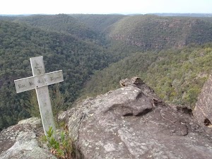
Lost Worlds Lookout is a cliff edge marked by a cross. The cross commemorates the Rev. Raymer who was a prominent bushwalker in the area, and has been commemorated by a plaque at Martins Lookout across the valley. The lookout views Glenbrook Creek valley below, the surrounding cliffs and down to Penrith in the west.
(2.14km) Int. Bunyan Lookout Trk and Lost Worlds Trk → Int. St Helena Ridge Trail and Bunyan Lookout Trk
2.7 km
47 mins
56m
-42m
Hard track
Continue straight: From the intersection, the walk heads in a southerly direction away from the red stump, keeping it behind on the right of the track. The walk winds through the bush, crossing a few sandy areas that lead to a small cairn marking the intersection, on the left of the track.
Continue straight: From the intersection, the walk heads in a southerly direction along the track. The walk meanders through the low green heath for quite some time, through a section of pines, before entering the clearing with a fire place.
Continue straight: From the intersection, the walk heads south-east through the bush. The track winds through the heath for a short time before opening onto a clearing with a rocky outcrop at the far side.
(4.85km) Int. St Helena Ridge Trail and Bunyah Lookout Trk → Int. Oaks Firetrail and cliff lookout Trk
6.9 km
2 hrs 21 mins
363m
-187m
Hard track
Turn right: From the clearing, the walk heads west out of the clearing along the single track. The walk then undulates and winds for quite some time with the track widening and narrowing greatly in many areas. The walk then zigzags up hill, climbing to the intersection with the Oaks Fire Trail.
Turn right: From the intersection, the walk heads down across the saddle and tends right below the cliff (above on the left). The trail winds up and onto a plateau lined with rocks, which look as though they could have been placed there. The vegetation along this higher area is lower and clearer, which gives views across the distant ridge lines. The walk continues to head in a northerly direction and descends right, off the plateau, to head up another hill to a stepped intersection on the left.
Turn right: From the intersection, the walk heads down across the saddle and tends right below the cliff (above on the left). The trail winds up and onto a plateau lined with rocks, which look as though they could have been placed there. The vegetation along this higher area is lower and clearer, which gives views across the distant ridge lines. The walk continues to head in a northerly direction and descends right, off the plateau, to head up another hill to a stepped intersection on the left.
(11.74km) Int. Oaks Firetrail and cliff lookout Trk → Cliff lookout
100 m
3 mins
5m
-18m
Hard track
Turn left: From the intersection, the walk heads away from the management trail, with the small depression (or waterhole) on the left, surrounded by reeds. The track winds up the hill, following the gap in the vegetation, leading to a rock shelf with a view. At the end of this side trip, retrace your steps back to the main walk then Turn left.
Cliff Lookout
Cliff lookout, an unofficially-named, informal view point, is a dramatic cliff edge perched just above the trees. The cliff is unfenced. The view across the valley provides a pleasant panorama.
(11.74km) Int. Oaks Firetrail and cliff lookout Trk → Int. Oaks Firetrail and Old Bathurst Rd
3.5 km
1 hr 10 mins
175m
-87m
Moderate track
Continue straight: From the intersection, this walk heads in a northerly direction down the hill, turning steeply up and to the left a few times. The trail passes a small dam (just to the right) and continues to wind and undulate for some time to a mound of dirt in the middle of a junction. The trail passes this mound of dirt and continues north, winding and undulating slightly for some time before passing an interpretative board (on the right). Soon after this, the trail comes up to a gate (with a tap for drinking water, on the right). The track crosses over this gate to the intersection with the road.
(15.22km) Int. Oaks Firetrail and Old Bathurst Rd → Woodford Station
730 m
15 mins
39m
-22m
Easy track
Turn left: From the intersection, the walk heads uphill along Taylor Rd, and soon turns right onto Parker St. The walk follows Parker St, tending right, then turns onto The Appian Way. The walk turns left at Railway Pde, just before a bridge. Continuing down Railway Pde, keeping the railway line on the right, the walk comes to a shelter on the left and railway sign on the right. The walk follows the footpath under the Woodford Station sign, leading under the tracks and up stairs onto the platform.
Maps for the Martin’s Lookout to Woodford Station walk
You can download the PDF for this walk to print a map.
These maps below cover the walk and the wider area around the walk, they are worth carrying for safety reasons.
| Springwood | 1:25 000 Map Series | 90304S SPRINGWOOD | NSW-90304S |
| Penrith | 1:25 000 Map Series | 90303N PENRITH | NSW-90303N |
| Jamison | 1:25 000 Map Series | 89302N JAMISON | NSW-89302N |
| Katoomba | 1:25 000 Map Series | 89301S KATOOMBA | NSW-89301S |
| Penrith | 1:100 000 Map Series | 9030 PENRITH | 9030 |
| Katoomba | 1:100 000 Map Series | 8930 KATOOMBA | 8930 |
Cross sectional view of the Martin’s Lookout to Woodford Station bushwalking track
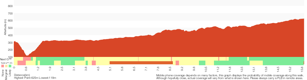
Analysis and summary of the altitude variation on the Martin’s Lookout to Woodford Station

Overview of this walks grade – based on the AS 2156.1 – 2001
Under this standard, a walk is graded based on the most difficult section of the walk.
| Length | 15.9 km | ||
| Time | 7 hrs | ||
| . | |||
| Grade 5/6 Experienced only |
AS 2156.1 | Gradient | Very steep (4/6) |
| Quality of track | Rough unclear track (5/6) | ||
| Signs | No directional signs (5/6) | ||
| Experience Required | No experience required (1/6) | ||
| Weather | Weather generally has little impact on safety (1/6) | ||
| Infrastructure | Limited facilities (such as cliffs not fenced, significant creeks not bridged) (4/6) |
Some more details of this walks Grading
Here is a bit more details explaining grading looking at sections of the walk
Gradient
10km of this walk has short steep hills and another 2.9km has gentle hills with occasional steps. Whilst another 1.5km is very steep and the remaining 1.1km is flat with no steps.
Quality of track
8km of this walk follows a rough track, where fallen trees and other obstacles are likely and another 6km follows a formed track, with some branches and other obstacles. Whilst another 960m follows a rough unclear track and a 730m section follows a smooth and hardened path. The remaining 60m follows a clear and well formed track or trail.
Signs
8km of this walk has minimal directional signs and another 7km has directional signs at most intersection. Whilst another 960m Has no directional signs and the remaining 790m is clearly signposted.
Experience Required
This whole walk, 16km requires no previous bushwalking experience.
weather
This whole walk, 16km is not usually affected by severe weather events (that would unexpectedly impact safety and navigation).
Infrastructure
9km of this walk has limited facilities (such as cliffs not fenced, significant creeks not bridged) and another 6km has limited facilities (such as not all cliffs fenced). The remaining (790m) is close to useful facilities (such as fenced cliffs and seats).
Similar walks
A list of walks that share part of the track with the Martin’s Lookout to Woodford Station walk.
180 m Return
15 mins
Moderate track
1.2 km Return
1 hr 30 mins
Hard track
3.1 km Return
3 hrs 30 mins
Experienced only
5.4 km Return
3 hrs 30 mins
Experienced only
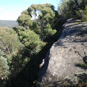
8.6 km Return
3 hrs 30 mins
Hard track
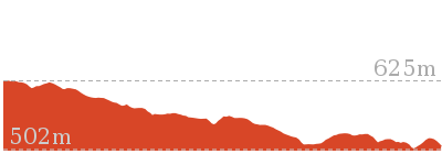
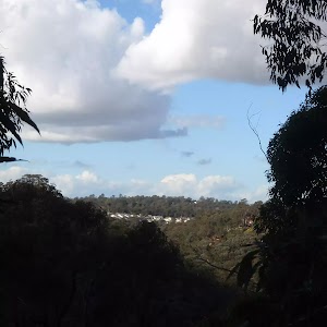
13.5 km One way
6 hrs
Experienced only
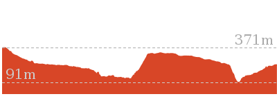
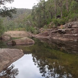
13.8 km Circuit
6 hrs 30 mins
Hard track
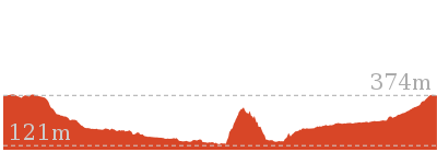
15.2 km One way
2 Days
Experienced only
18.1 km One way
7 hrs
Hard track
18.3 km One way
7 hrs 15 mins
Experienced only
23.4 km One way
2 Days
Experienced only
29.6 km One way
3 Days
Hard track
Other Nearby walks
A list of walks that start near the Martin’s Lookout to Woodford Station walk.
2.6 km Circuit
1 hr 30 mins
Hard track
2.9 km One way
2 hrs
Hard track
4.3 km Circuit
2 hrs 30 mins
Hard track
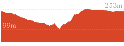
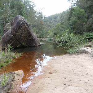
4 km Return
2 hrs
Hard track
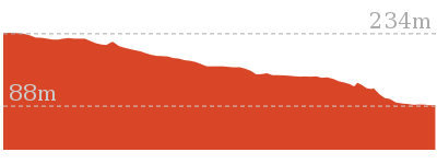

6 km One way
3 hrs
Hard track
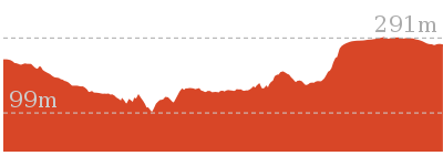
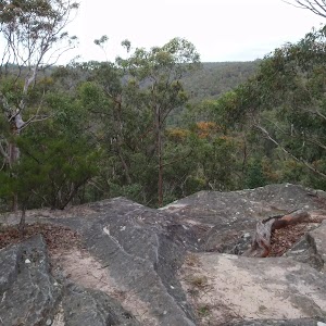
202 m Return
15 mins
Moderate track
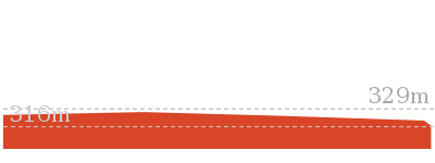
10.5 km Circuit
4 hrs 15 mins
Hard track
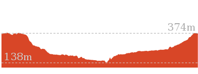
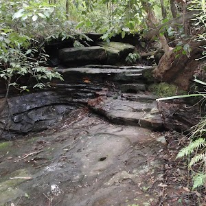
2.7 km Return
1 hr 30 mins
Hard track
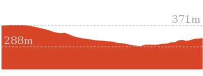
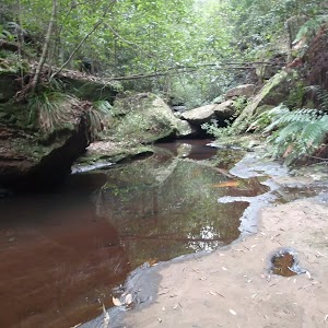
11.5 km One way
5 hrs
Hard track
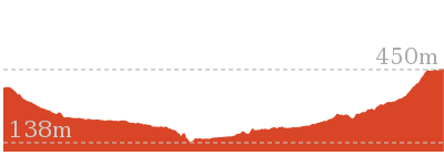
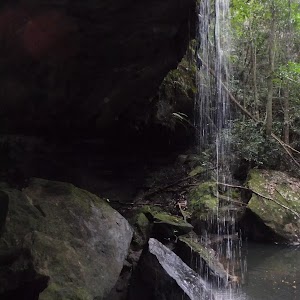
9 km Return
4 hrs
Hard track
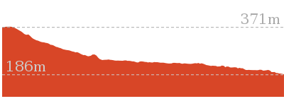
1 km Return
30 mins
Moderate track
4.1 km Circuit
2 hrs
Moderate track
Plan your trip to and from the walk here
The Martin’s Lookout to Woodford Station walk starts at the Int. Martins Lookout and Short Trks (gps: -33.734502, 150.57562)
Your transport options to Int. Martins Lookout and Short Trks are by;
![]() Car. There is free parking available.
Car. There is free parking available.
(get details)
![]() Train. (get details)
Train. (get details)
The Martin’s Lookout to Woodford Station ends at the Woodford Station (gps: -33.735763, 150.48228)
Your transport options to Woodford Station are by;
![]() Bus. (get details)
Bus. (get details)
![]() Car. There is free parking available.
Car. There is free parking available.
(get details)
Short URL = http://wild.tl/mltws
Gallery images
There are other downloads I am still working on.
You will probably need to login to access these — still all free.
* KML (google earth file)
* GPX (GPS file)
Special Maps/ brochures
* A3 topo maps
* PDF with Lands Topo map base
* PDF with arial image (and map overlay)
I wanted to get the main site live first, this extra stuff will come in time.
Happy walking
Matt 🙂
Glenbrook and Euroka Circuit
And Walk
Glenbrook and Euroka Circuit

2 Days
16.6 km Circuit
790 m
Experienced only
This two day circuit, returning to Glenbrook Station, is a scenic walk which passes many of the tourist attractions within the park. The walk winds through some wonderful valleys, and various natural and historic features, sleeping the night high on the ridge at Darug camping area. A great way to spend a weekend walking near Glenbrook.* This walk passes through very remote areas and sections have no visible track. At least one person in your group should have training and experience in off track walking and navigation. Even with these notes and a GPS these extra skills and equipment are required.
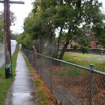
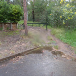
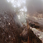
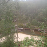
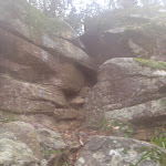
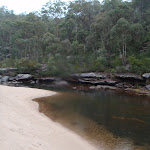
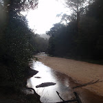

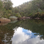

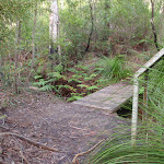
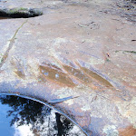
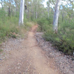
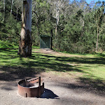
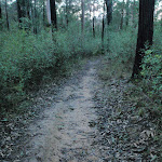


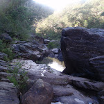

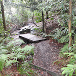
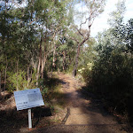
Glenbrook
Glenbrook is situated on the Great Western Highway and is a tourist hub for the lower Blue Mountains, with the Blue Mountains Visitor Information Centre located here. Glenbrook has quite a bustling little town centre with a number of cafes, bakeries and shops to explore. Prior to 1879, Glenbrook had changed its name numerous times, known at various times as Watertank, Wascoe Siding and Brookdale before being given its current name by Sir John Jamieson. Glenbrook is a gateway into the Blue Mountains National Park and is also the end point of the Woodford-Glenbrook mountain bike trail, along the Oaks Fire Trail. More info.
(0km) Glenbrook Station → End of Station St
580 m
10 mins
16m
-9m
Moderate track
From the top of Glenbrook Station, this walk turns left along Burfitt Pde (keeping the train line to the left of the footpath). The walk turns left over the bridge on Cowdery St and then the first right after the bridge, Station St. The walk continues to the bottom of Station St where there is a gate.
(0.58km) End of Station St → Station St mngt trail
650 m
12 mins
6m
-16m
Easy track
Veer left: From the intersection, the walk follows the trail along the back of the houses, keeping them on the left. The walk follows the straightest management trail, passing numerous side trails (that head off the ridge). The trail then leads over a number of water bars as the relatively straight trail meets the bush, where a defined single track continues down the hill.
(1.23km) Station St mngt trail → Glenbrook Creek Beach
430 m
17 mins
7m
-102m
Hard track
Turn left: From the intersection, the walk heads follows the bush track, downhill. The track steeply winds down over rock platforms and under overhangs, using a number of slots and cracks to descend the hill. The track continues winding steeply down the hill, coming to be near a sandy beach where the track climbs down a slot in the rock to reach the sand. The track then continues out across the sand to the turning point in the creek.
Glenbrook Creek Sandbar

The sandbar is an unofficially-named beach on the banks of Glenbrook Creek. The beach has a fantastic white colour and some height above the water – a great spot for to camp or enjoy lunch.
(1.66km) Glenbrook Creek Beach → Int. Blue Pool and Glenbrook Gorge trks
1 km
26 mins
68m
-72m
Hard track
Turn left : From the beach, the walk keeps the water on the right as it heads to the end of the beach. The walk then crosses the creek over the rock platform and winds along the bank for quite some time. The track passes a rock overhang as it continues to undulate and wind above the creek (which is on the left). Tending right at a wider area of the creek (forming a pool), the track then turns left, crossing the again-narrow creek at a rocky section and leading up to an intersection, below a cliff line.
(2.69km) Int. Blue Pool and Glenbrook Gorge trks → Blue Pool
70 m
1 mins
2m
-2m
Hard track
Turn left: From the intersection, the walk keeps the water to the left as the track meanders below the cliffs for a very short time, to the bank of Blue Pool. At the end of this side trip, retrace your steps back to the main walk then Continue straight.
Blue Pool

Blue Pool, Blue Mountains National Park, is named after the blue colour of the water. This appearance is caused by clay particles suspended in the water, which refract the light . This part of Glenbrook Creek is a popular swimming hole, but it is not patrolled.
(2.69km) Int. Blue Pool and Glenbrook Gorge trks → Int. Bruce Rd and Bruce Rd access trk
210 m
7 mins
24m
-18m
Hard track
Turn right: From the intersection, the walk heads alongside the creek (keeping the creek to the right). The track soon turns left up many steps, and comes to an un-signposted intersection below the road.
Turn right: From the intersection, the walk heads across the hillside tending left to a ‘Blue Pool’ sign at a corner in a road.
Turn right: From the intersection, the walk heads across the hillside tending left to a ‘Blue Pool’ sign at a corner in a road.
(2.9km) Int. Bruce Rd and Bruce Rd access trk → Eastern side of Causeway
230 m
5 mins
5m
-13m
Moderate track
Veer right: From the intersection, the walk heads down the road to the start of the causeway, with the fenced clearing to the left of the road.
Glenbrook causeway
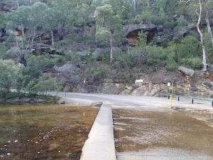
Glenbrook causeway is the only way for vehicles to cross Glenbrook Creek. It is a concrete road, with a raised gutter for pedestrians to cross the creek. The causeway is subject to flooding. Glenbrook causeway is a crossing point for many of the popular walks throughout the Glenbrook Valley area.
(3.13km) Eastern side of Causeway → Campfire Creek sign side of Causeway
10 m
1m
0m
Moderate track
Veer right: From the paved area side of the causeway, the walk crosses the creek via the causeway, then heads to the area beneath the ‘Camp Fire Creek Track’ sign. The causeway may be impassable after rain.
(3.15km) Campfire Creek sign side of Causeway → Red Hands Cave
3.1 km
1 hr 12 mins
208m
-92m
Moderate track
Turn right: From the causeway, the walk follows the ‘Camp Fire Creek Track’ sign along the water’s edge to the signposts for ‘Red Hands Cave’ and ‘Car park’.
Continue straight: From the intersection, the walk follows the ‘Red Hands Cave’ sign, keeping the creek to the right. The track winds and undulates, soon coming to a rock platform which crosses a creek (with the gully on the left). Here, the walk continues along the lower track, not heading up the rock steps. The track continues along the hillside and comes to a sign titled ‘Neighbours’.
Continue straight: From the intersection, the walk heads across the small bridge and up the track. The walk soon passes over another small wooden bridge and then continues through the bush, with the creek on the right. Winding for a short time, the track comes to an un-signposted intersection.
Turn left: From the intersection, the walk heads up the hill, winding above the creek (on the right). The track follows the hillside for quite some time, passing near the creek in places, before coming to a ‘Glenbrook Causeway’ sign.
Continue straight: From the intersection, the walk follows the ‘Red Hands Cave’ sign down across the creek. The track leads over a small rise across another smaller creek, then follows the hillside for a short while, passing a bench seat and then a small log bridge. The track then starts tending left, heading up to a rocky outcrop where the walk arrives at the metal verandah of Red Hands Cave.
Red Hands Cave
Red Hands Cave, in the Glenbrook area of the Blue Mountains National Park, is found near the end of Red Hands Cave fire trail. The cave has quite a few hand stencils and prints of various colours (including red). The cave is well protected, with a perspex and steel cage. There are some information signs and some artifacts to help visitors learn more about the people who made these prints over 1600 years ago. In 1913, when searching for a lost child, this cave was found by Europeans and is now protected.
(6.21km) Red Hands Cave → Red Hands Cave car park
500 m
12 mins
41m
-10m
Moderate track
Continue straight: From Red Hands Cave, the walk heads up the stairs, winding to be above Red Hands Cave. The track then continues across the rocky surface, slowly climbing through the bush and leading away from the rock outcrop. The track winds through a few rocky outcrops, tending right, before coming to a car park and ‘Red Hands Cave’ sign (pointing back to the cave).
Red Hands Cave Picnic Area
Red Hands Cave Picnic Area is found at the end of the Red Hands Cave Fire Trail in the Glenbrook area of the Blue Mountains National Park. The small picnic area is next to the car park and has a couple of platforms (to act as both a table and seat) as well as a fire place and toilet. The toilet itself is wheelchair accessible, but access to the toilet is over moderately rough terrain. A good spot to rest when exploring Red Hands Cave.
(6.71km) Red Hands Cave car park → Axe Grinding Grooves
2.1 km
44 mins
42m
-161m
Moderate track
Turn left : From Red Hands Cave car park, the walk follows the sign for the ‘Link Track’ past the bench and fireplace and into the bush. The track winds down the hill via many steps, winding for quite some time, then comes near a creek, which it loosely follows. The walk then crosses this creek to the signposts on the other side.
Turn left: From the creek intersection, the walk follows the ‘Glenbrook Causeway’ sign, keeping the water on the left. The track continues up to a rock overhang from where it heads down the hill, coming near the creek again. The track follows the creek to a junction with another creek. To the left is a large sandstone area and approximately 10m along the track is a sign explaining the grooves in the sandstone.
Turn left: From the creek intersection, the walk follows the ‘Glenbrook Causeway’ sign, keeping the water on the left. The track continues up to a rock overhang from where it heads down the hill, coming near the creek again. The track follows the creek to a junction with another creek. To the left is a large sandstone area and approximately 10m along the track is a sign explaining the grooves in the sandstone.
Axe Grinding Grooves
These well-defined axe grinding groves are found on the sandstone bed of Camp Fire Creek. The grooves were formed by Aboriginal people when sharpening axes (or forming axe blanks). Rubbing the axe blanks would sharpen the stone into a more useful tool, and the process would also wear the sandstone, leaving these markings. These sites are typically found near water, as the water was added to make the stone more abrasive. Sites like this will fade in time due to erosion of the sandstone – please help them last as long as possible by not walking on, or close to the grooves. More info.
(8.8km) Axe Grinding Grooves → The Ironbark Picnic Area
970 m
19 mins
90m
-6m
Experienced only
Turn sharp right: From where the main track crosses the small side creek (just above the axe grinding site), this walk follows the rocky side creek south-east, upstream. After about 20m, the gully splits in two. This walk follows a narrow track on the spur between these two creeks. The track heads up the spur line and crosses a number of rocky outcrops. Near the top of the hill, the bush becomes quiet dense. The track then opens out on the wide Oaks cycleway.
Turn right: From the intersection, the walk follows the wide track south, gently down the hill as it bends to the left. The track then heads down the hill a bit more steeply, and crosses a gully before gently climbing the other side. Not far after the gully, the track comes to an un-signposted intersection with the Ironbark access track, on the left.
Turn left : From the intersection, the walk follows the narrower track east towards the road. The track opens up at the car park, and the walk crosses the road to the Ironbark picnic area.
Ironbark Picnic Area
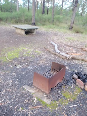
Ironbark Picnic Area is a basic picnic area on the Oaks Fire Trail, about 450m south of Euroka Rd. The picnic area has a low bench that acts as both a table and seat, and there is also a wood-fired barbecue provided. The picnic area is at the top of a gated management trail, which leads down to campsites at Euroka. There are plenty of car parking spaces provided and it is a fairly popular starting point for people cycling the Oaks Cycleway.
(9.76km) The Ironbark Picnic Area → Nioka Campsite
1.3 km
25 mins
4m
-94m
Moderate track
Continue straight: From the Ironbark Picnic Area, this walk follows the management trail south east by first stepping over the locked gate (pole). The wide trail then gently leads downhill. As the hill steepens a bit, the track becomes narrower. As the track approaches Euroka, there are a few sharp bends and the walk leads to the top of Nioka. The campsite comes into view, and the walk continues down the clear track, now with the camp ground on the right. The track then passes a toilet and continues down around the locked gate to the dirt road intersection just below Nioka campsite.
Euroka Campground – Red Gum
The Red Gum campground offers 20 sites to choose from. There is tap water at the park entrance.
Euroka Campground – Nioka
The Nioka campground offers 20 sites to choose from. There is tap water at the park entrance.
(11.07km) Nioka Campsite → Top of Darug campsite car park
240 m
5 mins
4m
-4m
Easy track
Veer left: From the dirt road just below the signposted ‘Nioka’ campsite, this walk follows the main road, initially keeping the campsite to the left. The walk heads across a small, bridged creek crossing and up to the intersection. At the intersection, there are some information signs about the area (on the right).
Continue straight: From the signposts, the walk follows the ‘Daruk’[2] arrow along the flat dirt road, keeping the hill up to the left. After passing the garbage bins, the trail crosses a small creek and comes to an intersection with a bush track on the left, just before the signposted ‘Darug’ campsite.
Continue straight: From the signposts, the walk follows the ‘Daruk’[2] arrow along the flat dirt road, keeping the hill up to the left. After passing the garbage bins, the trail crosses a small creek and comes to an intersection with a bush track on the left, just before the signposted ‘Darug’ campsite.
Euroka Campground – Darug
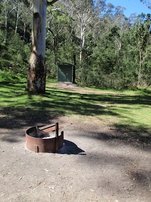
The Darug (sometimes labeled Daruk) campsite is found the Euroka Clearing, in the Glenbrook region of the Blue Mountains National Park. There are about 20 camping spaces to choose from in this area. Tap water is available at the park entrance. The campsite has a wheelchair-accessible toilet (access over grassy terrain) and a few metal fireplaces. The campsite is surrounded by large gum trees and is right at the base of a steep hill to the north.
End of day 1
This is the planned overnight stay for the end of day 1, happy camping.
(11.31km) Top of Darug campsite car park → Int. Euroka Trk and The Oaks Fire Trail
2.3 km
51 mins
111m
-103m
Hard track
Turn left: From between the small creek crossing and the ‘Darug’ campsite, the walk follows the bush track up the hill, initially keeping Darug to the right. There are two tracks at time of writing, nearly parallel and heading to the same place. The track becomes steep and works its way up the steep rocky hill. At the top of this climb, the walk follows the track to the right and then the clear track meanders through the scrub. The track soon comes to an intersection with the signposted ‘Portal waterhole’ track (which heads off to the right).
Continue straight: From the intersection, the walk heads north, following neither of the arrows on the sign. The track soon comes to Mount Portal Trail, just next to the intersection with Euroka Road.
Veer right: From the intersection, the walk follows the ‘The Causeway’ sign, along the bush track. The track tends right into the low grassy bush. As the track continues down the hill, the grass gives way to wattle bush covering the gully. The track leads down many stairs then crosses a creek or two before winding along the hillside. The track then continues down into the gully to pass a fading track, on the left, then winds through to a hairpin corner on the road, marked by a ‘Euroka Track’ sign (pointing back the way you came).
(13.62km) Int. Euroka Trk and The Oaks Fire Trail → Eastern side of Causeway
230 m
5 mins
0m
-28m
Moderate track
Veer right: From the intersection, the walk heads down the steep road to the causeway.
Veer right: From the southern side of the causeway, the walk heads across the causeway to the road, next to the fenced, paved area. The causeway may be impassable after rain.
Veer right: From the southern side of the causeway, the walk heads across the causeway to the road, next to the fenced, paved area. The causeway may be impassable after rain.
(13.85km) Eastern side of Causeway → Jelly Bean Pool
320 m
6 mins
5m
-6m
Hard track
Turn right: From the causeway, the walk heads through the blocked-off paved area, keeping the water on the right. The walk heads alongside the creek (the track is not very clear at this point) but winds around and over the large rocks beside the main creek (This creek does become impassable after heavy or prolonged rain). The soon the creek widens and turns into a large pool, where the track leads around the rocky outcrop to a metal staircase, above Jellybean Pool.
Jellybean Pool
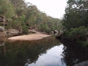
Jellybean Pool is a large pool in Glenbrook Creek, just south of the weir. The pool has a few sandy beaches, rock platforms and is surrounded by cliffs. Jumping and diving is not a good idea, and is not permitted. This is a popular spot for locals to swim. Swimming can be dangerous – the creek is especially dangerous after rain. Check with rangers before heading in.
(14.17km) Jelly Bean Pool → Int. Gorge Walking and Jelly Bean Pool Trk
600 m
14 mins
32m
-38m
Hard track
Continue straight: From the metal staircase at Jelly Bean Pools, the walk keeps the water on the right as it winds along the shore, downstream. The track meanders and undulates above the creek as it heads downstream to come to an intersection just before a small foot bridge.
Glenbrook Gorge
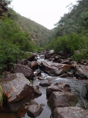
Glenbrook Gorge is a deep cut in the sandstone formed by Glenbrook Creek, just before it flows into the Nepean River. The spectacular gorge, the tall cliffs and the creek make for a great place to cool down in summer. The gorge can be very dangerous after rain, check with the rangers before entering.
(14.77km) Int. Gorge Walking and Jelly Bean Pool Trk → Glenbrook Information Centre car park
560 m
18 mins
91m
-2m
Hard track
Veer left: From the intersection, the walk heads up the hill keeping the gorge on the left. The track has many stairs which lead it to the road (just after passing the ‘Glenbrook Gorge walking track’ sign). The walk continues up the road, passing a small track (on the left) before coming to the Glenbrook Information Centre car park (just inside the National Park on Bruce Road).
NPWS Glenbrook Information Centre
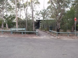
The NPWS information centre and car park are found just before the ‘toll both’ on Bruce Road. You will find tap water, toilets, garbage bins and information signs about the region. A great spot to chat to staff and get updates on the conditions in the park.
(15.33km) Glenbrook Information Centre car park → Glenbrook Station
1.3 km
23 mins
35m
-13m
Moderate track
Continue straight: From the car park, the walk joins the road and heads up the hill. The walk continues along the road, Bruce Rd, over a bridge and winds for some time. The walk follows the footpath on the left of the road, continuing as Bruce Rd becomes Burfitt Pde. The walk passes Euroka Rd on the right and soon comes to Glenbrook Station on the left.
Maps for the Glenbrook and Euroka Circuit walk
You can download the PDF for this walk to print a map.
These maps below cover the walk and the wider area around the walk, they are worth carrying for safety reasons.
| Penrith | 1:25 000 Map Series | 90303N PENRITH | NSW-90303N |
| Penrith | 1:100 000 Map Series | 9030 PENRITH | 9030 |
Cross sectional view of the Glenbrook and Euroka Circuit bushwalking track
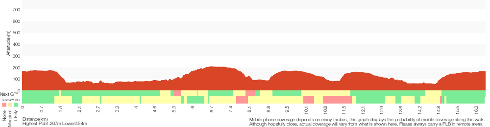
Analysis and summary of the altitude variation on the Glenbrook and Euroka Circuit
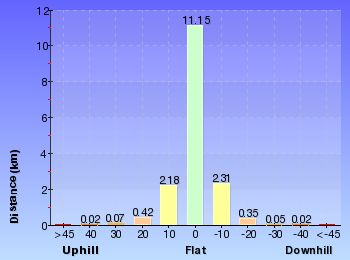
Daily actual walking time estimates
| Day | Walking Time | Length |
|---|---|---|
| 1 | 4 hrs 15 mins | 11.4 km |
| 2 | 1 hr 57 mins | 5.3 km |
Overview of this walks grade – based on the AS 2156.1 – 2001
Under this standard, a walk is graded based on the most difficult section of the walk.
| Length | 16.6 km | ||
| Time | 2 Days | ||
| . | |||
| Grade 5/6 Experienced only |
AS 2156.1 | Gradient | Very steep (4/6) |
| Quality of track | Rough track, where fallen trees and other obstacles are likely (4/6) | ||
| Signs | No directional signs (5/6) | ||
| Experience Required | Moderate level of bushwalking experience recommended (4/6) | ||
| Weather | Storms may impact on navigation and safety (3/6) | ||
| Infrastructure | No facilities provided (5/6) |
Some more details of this walks Grading
Here is a bit more details explaining grading looking at sections of the walk
Gradient
9km of this walk has short steep hills and another 5km is very steep. Whilst another 2.2km has gentle hills with occasional steps and the remaining 25m is flat with no steps.
Quality of track
9km of this walk follows a formed track, with some branches and other obstacles and another 3.1km follows a rough track, where fallen trees and other obstacles are likely. Whilst another 2.9km follows a smooth and hardened path and the remaining 2km follows a clear and well formed track or trail.
Signs
9km of this walk has directional signs at most intersection and another 4.5km is clearly signposted. Whilst another 2km has minimal directional signs and the remaining 710m Has no directional signs.
Experience Required
13km of this walk requires no previous bushwalking experience and another 2.3km requires some bushwalking experience. The remaining (1km) requires a leader a with moderate level of bushwalking experience.
weather
Around 16km of this walk is not usually affected by severe weather events (that would unexpectedly impact safety and navigation), whilst the remaining 1.1km is affected by storms that may impact your navigation and safety.
Infrastructure
10km of this walk is close to useful facilities (such as fenced cliffs and seats) and another 4.1km has limited facilities (such as not all cliffs fenced). Whilst another 1.8km has limited facilities (such as cliffs not fenced, significant creeks not bridged) and the remaining 710m has no facilities provided.
Similar walks
A list of walks that share part of the track with the Glenbrook and Euroka Circuit walk.
522 m Return
20 mins
Hard track
1 km Return
30 mins
Moderate track
1.7 km Return
1 hr 30 mins
Hard track
2.5 km Return
1 hr 15 mins
Hard track
4.1 km Circuit
2 hrs
Moderate track
4.3 km One way
1 hr 45 mins
Experienced only
4.4 km One way
2 hrs
Hard track
8.3 km Circuit
3 hrs 45 mins
Hard track
8.4 km Circuit
3 hrs 45 mins
Experienced only
18.8 km One way
2 Days
Very experienced only
29.6 km One way
3 Days
Hard track
Other Nearby walks
A list of walks that start near the Glenbrook and Euroka Circuit walk.
1 km Return
45 mins
Moderate track
1.4 km Return
1 Hr
Moderate track
2 km Circuit
1 Hr
Hard track
218 m Return
20 mins
Moderate track
756 m Return
30 mins
Hard track
3.2 km Return
1 hr 30 mins
Hard track
512 m Return
30 mins
Hard track
74 m Return
10 mins
Very easy
2.8 km Circuit
1 hr 15 mins
Hard track
4.3 km Circuit
2 hrs 30 mins
Hard track
4 km Return
2 hrs
Hard track
6 km One way
3 hrs
Hard track
Plan your trip to and from the walk here
The Glenbrook and Euroka Circuit walk starts and ends at the Glenbrook Station (gps: -33.76894, 150.62134)
Your transport options to Glenbrook Station are by;
![]() Train. (get details)
Train. (get details)
![]() Bus. (get details)
Bus. (get details)
![]() Car. There is free parking available.
Car. There is free parking available.
(get details)
Short URL = http://wild.tl/gsc
Gallery images
There are other downloads I am still working on.
You will probably need to login to access these — still all free.
* KML (google earth file)
* GPX (GPS file)
Special Maps/ brochures
* A3 topo maps
* PDF with Lands Topo map base
* PDF with arial image (and map overlay)
I wanted to get the main site live first, this extra stuff will come in time.
Happy walking
Matt 🙂
The Oaks Picnic area to Woodford Station

7 hrs
18.1 km One way
800 m
Hard track
The Oaks Picnic Area is the starting point for this long walk across the ridge line linking to Woodford. The Oaks Fire Trail winds its way over the hills, with many views into the surrounding valleys and bush land. This is a great walk to start extending your walking distance and stamina, while enjoying a scenic track. It does follow a management trail and is popular with mountain bike riders.
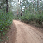

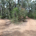
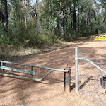
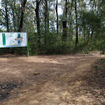


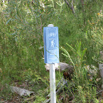
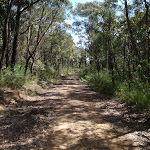
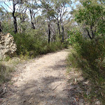

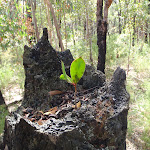
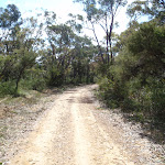
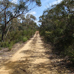
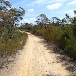
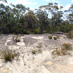
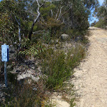
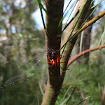
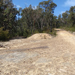
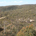
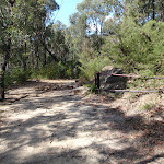
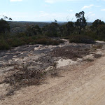
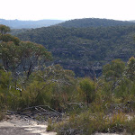

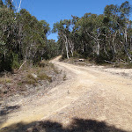

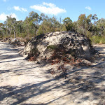
The Oaks Picnic Area
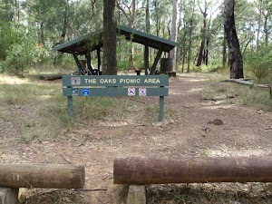
The Oaks Picnic Area, is an established picnic area with shelter, bench seats and a pit toilet. The picnic area also boasts a water tank and adequate parking. It is a quiet area, just off the road, making it a fantastic spot for a rendezvous with family and friends after a long walk or ride.
(0km) The Oaks Picnic Area → Int. Wheel Gully Trail and Oaks Firetrail
6 km
1 hr 59 mins
270m
-26m
Moderate track
From the car park, the walk heads along the management trail, with the picnic area on the right and car park to the left. The walk heads down the road for a very short time to the signposted intersection.
Veer left: From the intersection, the walk heads past the Red Hand Cave intersection and west along the management trail, with the picnic area on the right and car park to the left. The walk heads down the road for a very short time, to the signposted intersection.
Continue straight: From the intersection, the walk does not head in the direction of ‘Nepean lookout’ but leads to the gate and fence up the other trail.
Continue straight: From the intersection, the walk heads up the slight hill, passing the gate. The trail winds slowly as it climbs the gentle slope for quite some time. The trail then flattens out and leads to a steeper gradient, and at the top, comes to a ’15km to Woodford’ sign.
Continue straight: From the sign, the walk continues upwards along the trail, winding slowly for some kilometres. The vegetation either side of the trail stays relatively the same, passing some clearings with demolished trees in them. As the trail begins to head north, it continues to wind uphill, passing a large clearing on the left. Soon after the large clearing, the walk comes to an intersection on the right, before the track turns left sharply.
(6.03km) Int. Wheel Gully Trail and Oaks Firetrail → Int. in Wheel Gully loop
220 m
4 mins
4m
-21m
Moderate track
Turn right: From the intersection, the walk heads down the hill, almost immediately coming to a split in the track, with both tracks heading down the hill.
Continue straight: From the intersection the track heads down the left or right track to wind around and down to a dam. From the dam the track winds back up either track to the intersection. At the end of this side trip, retrace your steps back to the main walk then Turn right.
Continue straight: From the intersection the track heads down the left or right track to wind around and down to a dam. From the dam the track winds back up either track to the intersection. At the end of this side trip, retrace your steps back to the main walk then Turn right.
Wheel Gully
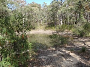
Wheel Gully has a management trail which loops down to a large dam. It is a nice shady place to stop for a bite to eat along the Oaks Fire Trail. This site is also used as an informal campsite with no facilities. The water in the dam is not suitable for drinking, nor is it reliable. Carry enough water.
(6.03km) Int. Wheel Gully Trail and Oaks Firetrail → Int. Oaks Firetrail and cliff lookout Trk
7.9 km
2 hrs 45 mins
316m
-318m
Hard track
Continue straight: From the intersection the track heads around the corner turning left. The track then winds, while unudlating onto a plateau that has low vegetation. On this plateau the track is bordered by rocky surfaces on either side for a short time as it winds for a short time before heading down hill. The track heads down hill to continue into a saddle where a gate marks the intersection to the right.
Continue straight: From the intersection, the walk heads up the hill to the north, winding steeply up past a rock shelf with a view (on the left). The track continues steeply uphill, then winds across a plateau with rocky surfaces to both sides of the track. The vegetation here is also lower and sparser, giving views of the surrounding valleys. The track winds across this plateau and hillsides for some time before descending steeply, passing a blue marker sign on the right before coming to the intersection with St Helena Ridge Trail.
Continue straight: From the intersection, the walk heads down across the saddle and tends right below the cliff (above on the left). The trail winds up and onto a plateau lined with rocks, which look as though they could have been placed there. The vegetation along this higher area is lower and clearer, which gives views across the distant ridge lines. The walk continues to head in a northerly direction and descends right, off the plateau, to head up another hill to a stepped intersection on the left.
(13.91km) Int. Oaks Firetrail and cliff lookout Trk → Cliff lookout
100 m
3 mins
5m
-18m
Hard track
Turn left: From the intersection, the walk heads away from the management trail, with the small depression (or waterhole) on the left, surrounded by reeds. The track winds up the hill, following the gap in the vegetation, leading to a rock shelf with a view. At the end of this side trip, retrace your steps back to the main walk then Turn left.
Cliff Lookout
Cliff lookout, an unofficially-named, informal view point, is a dramatic cliff edge perched just above the trees. The cliff is unfenced. The view across the valley provides a pleasant panorama.
(13.91km) Int. Oaks Firetrail and cliff lookout Trk → Int. Oaks Firetrail and Old Bathurst Rd
3.5 km
1 hr 10 mins
175m
-87m
Moderate track
Continue straight: From the intersection, this walk heads in a northerly direction down the hill, turning steeply up and to the left a few times. The trail passes a small dam (just to the right) and continues to wind and undulate for some time to a mound of dirt in the middle of a junction. The trail passes this mound of dirt and continues north, winding and undulating slightly for some time before passing an interpretative board (on the right). Soon after this, the trail comes up to a gate (with a tap for drinking water, on the right). The track crosses over this gate to the intersection with the road.
(17.38km) Int. Oaks Firetrail and Old Bathurst Rd → Woodford Station
730 m
15 mins
39m
-22m
Easy track
Turn left: From the intersection, the walk heads uphill along Taylor Rd, and soon turns right onto Parker St. The walk follows Parker St, tending right, then turns onto The Appian Way. The walk turns left at Railway Pde, just before a bridge. Continuing down Railway Pde, keeping the railway line on the right, the walk comes to a shelter on the left and railway sign on the right. The walk follows the footpath under the Woodford Station sign, leading under the tracks and up stairs onto the platform.
Maps for the The Oaks Picnic area to Woodford Station walk
You can download the PDF for this walk to print a map.
These maps below cover the walk and the wider area around the walk, they are worth carrying for safety reasons.
| Springwood | 1:25 000 Map Series | 90304S SPRINGWOOD | NSW-90304S |
| Penrith | 1:25 000 Map Series | 90303N PENRITH | NSW-90303N |
| Jamison | 1:25 000 Map Series | 89302N JAMISON | NSW-89302N |
| Katoomba | 1:25 000 Map Series | 89301S KATOOMBA | NSW-89301S |
| Penrith | 1:100 000 Map Series | 9030 PENRITH | 9030 |
| Katoomba | 1:100 000 Map Series | 8930 KATOOMBA | 8930 |
Cross sectional view of the The Oaks Picnic area to Woodford Station bushwalking track
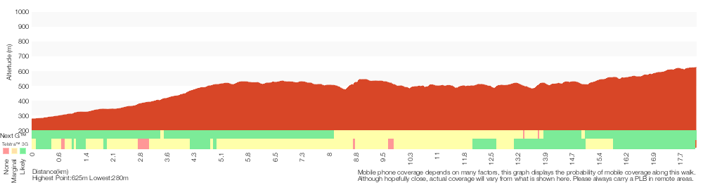
Analysis and summary of the altitude variation on the The Oaks Picnic area to Woodford Station
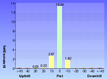
Overview of this walks grade – based on the AS 2156.1 – 2001
Under this standard, a walk is graded based on the most difficult section of the walk.
| Length | 18.1 km | ||
| Time | 7 hrs | ||
| . | |||
| Grade 4/6 Hard track |
AS 2156.1 | Gradient | Very steep (4/6) |
| Quality of track | Formed track, with some branches and other obstacles (3/6) | ||
| Signs | Minimal directional signs (4/6) | ||
| Experience Required | No experience required (1/6) | ||
| Weather | Weather generally has little impact on safety (1/6) | ||
| Infrastructure | Limited facilities, not all cliffs are fenced (3/6) |
Some more details of this walks Grading
Here is a bit more details explaining grading looking at sections of the walk
Gradient
11km of this walk has short steep hills and another 4km is very steep. Whilst another 3.1km has gentle hills with occasional steps and the remaining 270m is flat with no steps.
Quality of track
12km of this walk follows a formed track, with some branches and other obstacles and another 6km follows a clear and well formed track or trail. The remaining (730m) follows a smooth and hardened path.
Signs
13km of this walk has directional signs at most intersection and another 4km has minimal directional signs. The remaining (930m) is clearly signposted.
Experience Required
This whole walk, 18km requires no previous bushwalking experience.
weather
This whole walk, 18km is not usually affected by severe weather events (that would unexpectedly impact safety and navigation).
Infrastructure
Around 17km of this walk has limited facilities (such as not all cliffs fenced), whilst the remaining 730m is close to useful facilities (such as fenced cliffs and seats).
Similar walks
A list of walks that share part of the track with the The Oaks Picnic area to Woodford Station walk.
8.6 km Return
3 hrs 30 mins
Hard track
15.9 km One way
7 hrs
Experienced only
18.3 km One way
7 hrs 15 mins
Experienced only
23.4 km One way
2 Days
Experienced only
29.6 km One way
3 Days
Hard track
Other Nearby walks
A list of walks that start near the The Oaks Picnic area to Woodford Station walk.
2 km Return
1 Hr
Experienced only
6 km Return
4 hrs
Very experienced only
10.3 km Circuit
2 Days
Very experienced only
2.8 km Return
3 hrs
Very experienced only
7.1 km Circuit
4 hrs 30 mins
Very experienced only
1.6 km Return
45 mins
Moderate track
466 m Return
15 mins
Moderate track
648 m Return
20 mins
Moderate track
2.6 km Return
2 hrs
Experienced only
1.3 km Return
30 mins
Moderate track
4.3 km One way
1 hr 45 mins
Experienced only
2.8 km Circuit
1 hr 15 mins
Hard track
Plan your trip to and from the walk here
The The Oaks Picnic area to Woodford Station walk starts at the The Oaks Picnic Area (gps: -33.811583, 150.56521)
Your transport options to The Oaks Picnic Area are by;
![]() Car. A park entry fee is required for driving into the park.
Car. A park entry fee is required for driving into the park.
(get details)
![]() Train. (get details)
Train. (get details)
The The Oaks Picnic area to Woodford Station ends at the Woodford Station (gps: -33.735763, 150.48228)
Your transport options to Woodford Station are by;
![]() Bus. (get details)
Bus. (get details)
![]() Car. There is free parking available.
Car. There is free parking available.
(get details)
Short URL = http://wild.tl/topatws
Gallery images
There are other downloads I am still working on.
You will probably need to login to access these — still all free.
* KML (google earth file)
* GPX (GPS file)
Special Maps/ brochures
* A3 topo maps
* PDF with Lands Topo map base
* PDF with arial image (and map overlay)
I wanted to get the main site live first, this extra stuff will come in time.
Happy walking
Matt 🙂
Glenbrook to Lapstone via Euroka
And Walk
Glenbrook to Lapstone via Euroka

2 Days
18.8 km One way
1136 m
Very experienced only
This two day walk covers large sections of the Glenbrook Gorge between the two train stations. As well as winding through the gorge, the walk travels up onto the ridges to pass Red Hands Cave and camp the night at Darug camping area. The gorge section from the causeway to the Nepean River presents many opportunities to get your feet wet, too. This is a wonderfully picturesque and challenging walk.* This walk passes through very remote areas and sections have no visible track. At least one person in your group should have training and experience in off track walking and navigation. Even with these notes and a GPS these extra skills and equipment are required.


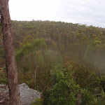
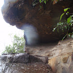
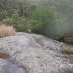

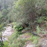


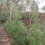


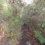
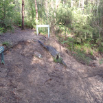

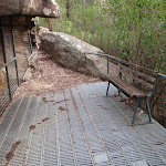

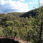
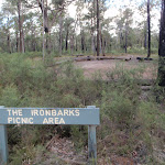

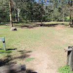

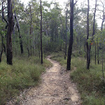

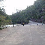


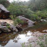
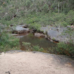
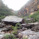

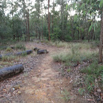
Glenbrook
Glenbrook is situated on the Great Western Highway and is a tourist hub for the lower Blue Mountains, with the Blue Mountains Visitor Information Centre located here. Glenbrook has quite a bustling little town centre with a number of cafes, bakeries and shops to explore. Prior to 1879, Glenbrook had changed its name numerous times, known at various times as Watertank, Wascoe Siding and Brookdale before being given its current name by Sir John Jamieson. Glenbrook is a gateway into the Blue Mountains National Park and is also the end point of the Woodford-Glenbrook mountain bike trail, along the Oaks Fire Trail. More info.
(0km) Glenbrook Station → End of Station St
580 m
10 mins
16m
-9m
Moderate track
From the top of Glenbrook Station, this walk turns left along Burfitt Pde (keeping the train line to the left of the footpath). The walk turns left over the bridge on Cowdery St and then the first right after the bridge, Station St. The walk continues to the bottom of Station St where there is a gate.
(0.58km) End of Station St → Station St mngt trail
650 m
12 mins
6m
-16m
Easy track
Veer left: From the intersection, the walk follows the trail along the back of the houses, keeping them on the left. The walk follows the straightest management trail, passing numerous side trails (that head off the ridge). The trail then leads over a number of water bars as the relatively straight trail meets the bush, where a defined single track continues down the hill.
(1.23km) Station St mngt trail → Glenbrook Creek Beach
430 m
17 mins
7m
-102m
Hard track
Turn left: From the intersection, the walk heads follows the bush track, downhill. The track steeply winds down over rock platforms and under overhangs, using a number of slots and cracks to descend the hill. The track continues winding steeply down the hill, coming to be near a sandy beach where the track climbs down a slot in the rock to reach the sand. The track then continues out across the sand to the turning point in the creek.
Glenbrook Creek Sandbar
The sandbar is an unofficially-named beach on the banks of Glenbrook Creek. The beach has a fantastic white colour and some height above the water – a great spot for to camp or enjoy lunch.
(1.66km) Glenbrook Creek Beach → Int. Blue Pool and Glenbrook Gorge trks
1 km
26 mins
68m
-72m
Hard track
Turn left : From the beach, the walk keeps the water on the right as it heads to the end of the beach. The walk then crosses the creek over the rock platform and winds along the bank for quite some time. The track passes a rock overhang as it continues to undulate and wind above the creek (which is on the left). Tending right at a wider area of the creek (forming a pool), the track then turns left, crossing the again-narrow creek at a rocky section and leading up to an intersection, below a cliff line.
(2.69km) Int. Blue Pool and Glenbrook Gorge trks → Blue Pool
70 m
1 mins
2m
-2m
Hard track
Turn left: From the intersection, the walk keeps the water to the left as the track meanders below the cliffs for a very short time, to the bank of Blue Pool. At the end of this side trip, retrace your steps back to the main walk then Continue straight.
Blue Pool
Blue Pool, Blue Mountains National Park, is named after the blue colour of the water. This appearance is caused by clay particles suspended in the water, which refract the light . This part of Glenbrook Creek is a popular swimming hole, but it is not patrolled.
(2.69km) Int. Blue Pool and Glenbrook Gorge trks → Int. Bruce Rd and Bruce Rd access trk
210 m
7 mins
24m
-18m
Hard track
Turn right: From the intersection, the walk heads alongside the creek (keeping the creek to the right). The track soon turns left up many steps, and comes to an un-signposted intersection below the road.
Turn right: From the intersection, the walk heads across the hillside tending left to a ‘Blue Pool’ sign at a corner in a road.
Turn right: From the intersection, the walk heads across the hillside tending left to a ‘Blue Pool’ sign at a corner in a road.
(2.9km) Int. Bruce Rd and Bruce Rd access trk → Eastern side of Causeway
230 m
5 mins
5m
-13m
Moderate track
Veer right: From the intersection, the walk heads down the road to the start of the causeway, with the fenced clearing to the left of the road.
Glenbrook causeway
Glenbrook causeway is the only way for vehicles to cross Glenbrook Creek. It is a concrete road, with a raised gutter for pedestrians to cross the creek. The causeway is subject to flooding. Glenbrook causeway is a crossing point for many of the popular walks throughout the Glenbrook Valley area.
(3.13km) Eastern side of Causeway → Campfire Creek sign side of Causeway
10 m
1m
0m
Moderate track
Veer right: From the paved area side of the causeway, the walk crosses the creek via the causeway, then heads to the area beneath the ‘Camp Fire Creek Track’ sign. The causeway may be impassable after rain.
(3.15km) Campfire Creek sign side of Causeway → Red Hands Cave
3.1 km
1 hr 12 mins
208m
-92m
Moderate track
Turn right: From the causeway, the walk follows the ‘Camp Fire Creek Track’ sign along the water’s edge to the signposts for ‘Red Hands Cave’ and ‘Car park’.
Continue straight: From the intersection, the walk follows the ‘Red Hands Cave’ sign, keeping the creek to the right. The track winds and undulates, soon coming to a rock platform which crosses a creek (with the gully on the left). Here, the walk continues along the lower track, not heading up the rock steps. The track continues along the hillside and comes to a sign titled ‘Neighbours’.
Continue straight: From the intersection, the walk heads across the small bridge and up the track. The walk soon passes over another small wooden bridge and then continues through the bush, with the creek on the right. Winding for a short time, the track comes to an un-signposted intersection.
Turn left: From the intersection, the walk heads up the hill, winding above the creek (on the right). The track follows the hillside for quite some time, passing near the creek in places, before coming to a ‘Glenbrook Causeway’ sign.
Continue straight: From the intersection, the walk follows the ‘Red Hands Cave’ sign down across the creek. The track leads over a small rise across another smaller creek, then follows the hillside for a short while, passing a bench seat and then a small log bridge. The track then starts tending left, heading up to a rocky outcrop where the walk arrives at the metal verandah of Red Hands Cave.
Continue straight: From the intersection, the walk follows the ‘Red Hands Cave’ sign, keeping the creek to the right. The track winds and undulates, soon coming to a rock platform which crosses a creek (with the gully on the left). Here, the walk continues along the lower track, not heading up the rock steps. The track continues along the hillside and comes to a sign titled ‘Neighbours’.
Continue straight: From the intersection, the walk heads across the small bridge and up the track. The walk soon passes over another small wooden bridge and then continues through the bush, with the creek on the right. Winding for a short time, the track comes to an un-signposted intersection.
Turn left: From the intersection, the walk heads up the hill, winding above the creek (on the right). The track follows the hillside for quite some time, passing near the creek in places, before coming to a ‘Glenbrook Causeway’ sign.
Continue straight: From the intersection, the walk follows the ‘Red Hands Cave’ sign down across the creek. The track leads over a small rise across another smaller creek, then follows the hillside for a short while, passing a bench seat and then a small log bridge. The track then starts tending left, heading up to a rocky outcrop where the walk arrives at the metal verandah of Red Hands Cave.
Red Hands Cave
Red Hands Cave, in the Glenbrook area of the Blue Mountains National Park, is found near the end of Red Hands Cave fire trail. The cave has quite a few hand stencils and prints of various colours (including red). The cave is well protected, with a perspex and steel cage. There are some information signs and some artifacts to help visitors learn more about the people who made these prints over 1600 years ago. In 1913, when searching for a lost child, this cave was found by Europeans and is now protected.
(6.21km) Red Hands Cave → Red Hands Cave car park
500 m
12 mins
41m
-10m
Moderate track
Continue straight: From Red Hands Cave, the walk heads up the stairs, winding to be above Red Hands Cave. The track then continues across the rocky surface, slowly climbing through the bush and leading away from the rock outcrop. The track winds through a few rocky outcrops, tending right, before coming to a car park and ‘Red Hands Cave’ sign (pointing back to the cave).
Red Hands Cave Picnic Area
Red Hands Cave Picnic Area is found at the end of the Red Hands Cave Fire Trail in the Glenbrook area of the Blue Mountains National Park. The small picnic area is next to the car park and has a couple of platforms (to act as both a table and seat) as well as a fire place and toilet. The toilet itself is wheelchair accessible, but access to the toilet is over moderately rough terrain. A good spot to rest when exploring Red Hands Cave.
(6.71km) Red Hands Cave car park → Axe Grinding Grooves
2.1 km
44 mins
42m
-161m
Moderate track
Turn left : From Red Hands Cave car park, the walk follows the sign for the ‘Link Track’ past the bench and fireplace and into the bush. The track winds down the hill via many steps, winding for quite some time, then comes near a creek, which it loosely follows. The walk then crosses this creek to the signposts on the other side.
Turn left: From the creek intersection, the walk follows the ‘Glenbrook Causeway’ sign, keeping the water on the left. The track continues up to a rock overhang from where it heads down the hill, coming near the creek again. The track follows the creek to a junction with another creek. To the left is a large sandstone area and approximately 10m along the track is a sign explaining the grooves in the sandstone.
Turn left: From the creek intersection, the walk follows the ‘Glenbrook Causeway’ sign, keeping the water on the left. The track continues up to a rock overhang from where it heads down the hill, coming near the creek again. The track follows the creek to a junction with another creek. To the left is a large sandstone area and approximately 10m along the track is a sign explaining the grooves in the sandstone.
Axe Grinding Grooves
These well-defined axe grinding groves are found on the sandstone bed of Camp Fire Creek. The grooves were formed by Aboriginal people when sharpening axes (or forming axe blanks). Rubbing the axe blanks would sharpen the stone into a more useful tool, and the process would also wear the sandstone, leaving these markings. These sites are typically found near water, as the water was added to make the stone more abrasive. Sites like this will fade in time due to erosion of the sandstone – please help them last as long as possible by not walking on, or close to the grooves. More info.
(8.8km) Axe Grinding Grooves → The Ironbark Picnic Area
970 m
19 mins
90m
-6m
Experienced only
Turn sharp right: From where the main track crosses the small side creek (just above the axe grinding site), this walk follows the rocky side creek south-east, upstream. After about 20m, the gully splits in two. This walk follows a narrow track on the spur between these two creeks. The track heads up the spur line and crosses a number of rocky outcrops. Near the top of the hill, the bush becomes quiet dense. The track then opens out on the wide Oaks cycleway.
Turn right: From the intersection, the walk follows the wide track south, gently down the hill as it bends to the left. The track then heads down the hill a bit more steeply, and crosses a gully before gently climbing the other side. Not far after the gully, the track comes to an un-signposted intersection with the Ironbark access track, on the left.
Turn left : From the intersection, the walk follows the narrower track east towards the road. The track opens up at the car park, and the walk crosses the road to the Ironbark picnic area.
Turn right: From the intersection, the walk follows the wide track south, gently down the hill as it bends to the left. The track then heads down the hill a bit more steeply, and crosses a gully before gently climbing the other side. Not far after the gully, the track comes to an un-signposted intersection with the Ironbark access track, on the left.
Turn left : From the intersection, the walk follows the narrower track east towards the road. The track opens up at the car park, and the walk crosses the road to the Ironbark picnic area.
Ironbark Picnic Area
Ironbark Picnic Area is a basic picnic area on the Oaks Fire Trail, about 450m south of Euroka Rd. The picnic area has a low bench that acts as both a table and seat, and there is also a wood-fired barbecue provided. The picnic area is at the top of a gated management trail, which leads down to campsites at Euroka. There are plenty of car parking spaces provided and it is a fairly popular starting point for people cycling the Oaks Cycleway.
(9.76km) The Ironbark Picnic Area → Nioka Campsite
1.3 km
25 mins
4m
-94m
Moderate track
Continue straight: From the Ironbark Picnic Area, this walk follows the management trail south east by first stepping over the locked gate (pole). The wide trail then gently leads downhill. As the hill steepens a bit, the track becomes narrower. As the track approaches Euroka, there are a few sharp bends and the walk leads to the top of Nioka. The campsite comes into view, and the walk continues down the clear track, now with the camp ground on the right. The track then passes a toilet and continues down around the locked gate to the dirt road intersection just below Nioka campsite.
Euroka Campground – Nioka
The Nioka campground offers 20 sites to choose from. There is tap water at the park entrance.
Euroka Campground – Red Gum
The Red Gum campground offers 20 sites to choose from. There is tap water at the park entrance.
(11.07km) Nioka Campsite → Top of Darug campsite car park
240 m
5 mins
4m
-4m
Easy track
Veer left: From the dirt road just below the signposted ‘Nioka’ campsite, this walk follows the main road, initially keeping the campsite to the left. The walk heads across a small, bridged creek crossing and up to the intersection. At the intersection, there are some information signs about the area (on the right).
Continue straight: From the signposts, the walk follows the ‘Daruk’[2] arrow along the flat dirt road, keeping the hill up to the left. After passing the garbage bins, the trail crosses a small creek and comes to an intersection with a bush track on the left, just before the signposted ‘Darug’ campsite.
Continue straight: From the signposts, the walk follows the ‘Daruk’[2] arrow along the flat dirt road, keeping the hill up to the left. After passing the garbage bins, the trail crosses a small creek and comes to an intersection with a bush track on the left, just before the signposted ‘Darug’ campsite.
Euroka Campground – Darug
The Darug (sometimes labeled Daruk) campsite is found the Euroka Clearing, in the Glenbrook region of the Blue Mountains National Park. There are about 20 camping spaces to choose from in this area. Tap water is available at the park entrance. The campsite has a wheelchair-accessible toilet (access over grassy terrain) and a few metal fireplaces. The campsite is surrounded by large gum trees and is right at the base of a steep hill to the north.
End of day 1
This is the planned overnight stay for the end of day 1, happy camping.
(11.31km) Top of Darug campsite car park → Campfire Creek sign side of Causeway
2.5 km
56 mins
111m
-130m
Hard track
Turn left: From between the small creek crossing and the ‘Darug’ campsite, the walk follows the bush track up the hill, initially keeping Darug to the right. There are two tracks at time of writing, nearly parallel and heading to the same place. The track becomes steep and works its way up the steep rocky hill. At the top of this climb, the walk follows the track to the right and then the clear track meanders through the scrub. The track soon comes to an intersection with the signposted ‘Portal waterhole’ track (which heads off to the right).
Continue straight: From the intersection, the walk heads north, following neither of the arrows on the sign. The track soon comes to Mount Portal Trail, just next to the intersection with Euroka Road.
Veer right: From the intersection, the walk follows the ‘The Causeway’ sign, along the bush track. The track tends right into the low grassy bush. As the track continues down the hill, the grass gives way to wattle bush covering the gully. The track leads down many stairs then crosses a creek or two before winding along the hillside. The track then continues down into the gully to pass a fading track, on the left, then winds through to a hairpin corner on the road, marked by a ‘Euroka Track’ sign (pointing back the way you came).
Veer right: From the intersection, the walk heads down the steep road to the causeway.
(13.84km) Campfire Creek sign side of Causeway → Eastern side of Causeway
10 m
0m
-1m
Moderate track
Veer right: From the southern side of the causeway, the walk heads across the causeway to the road, next to the fenced, paved area. The causeway may be impassable after rain.
(13.85km) Eastern side of Causeway → Jelly Bean Pool
320 m
6 mins
5m
-6m
Hard track
Turn right: From the causeway, the walk heads through the blocked-off paved area, keeping the water on the right. The walk heads alongside the creek (the track is not very clear at this point) but winds around and over the large rocks beside the main creek (This creek does become impassable after heavy or prolonged rain). The soon the creek widens and turns into a large pool, where the track leads around the rocky outcrop to a metal staircase, above Jellybean Pool.
Jellybean Pool
Jellybean Pool is a large pool in Glenbrook Creek, just south of the weir. The pool has a few sandy beaches, rock platforms and is surrounded by cliffs. Jumping and diving is not a good idea, and is not permitted. This is a popular spot for locals to swim. Swimming can be dangerous – the creek is especially dangerous after rain. Check with rangers before heading in.
(14.17km) Jelly Bean Pool → Int. Gorge Walking and Jelly Bean Pool Trk
600 m
14 mins
32m
-38m
Hard track
Continue straight: From the metal staircase at Jelly Bean Pools, the walk keeps the water on the right as it winds along the shore, downstream. The track meanders and undulates above the creek as it heads downstream to come to an intersection just before a small foot bridge.
Glenbrook Gorge
Glenbrook Gorge is a deep cut in the sandstone formed by Glenbrook Creek, just before it flows into the Nepean River. The spectacular gorge, the tall cliffs and the creek make for a great place to cool down in summer. The gorge can be very dangerous after rain, check with the rangers before entering.
(14.77km) Int. Gorge Walking and Jelly Bean Pool Trk → Glenbrook Gorge Beach
270 m
7 mins
9m
-20m
Hard track
Veer right: From the intersection, the walk crosses the footbridge and continues along the hillside, keeping the main creek to the right. The walk winds down past a pond (on the right) and continue downstream to a sandy beach.
Glenbrook Gorge Beach
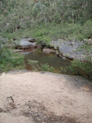
Glenbrook Gorge Beach is a small, sandy spot on a rock platform in Glenbrook Gorge. The beach is beside a fairly large pool, making a great spot to rest, especially on warmer days.
(15.05km) Glenbrook Gorge Beach → Int. at junction of Nepean River and Glenbrook Creek
2.1 km
1 hr 23 mins
332m
-357m
Very experienced only
Continue straight: From the beach, the walk heads downstream, keeping the creek on the right for some time. The track winds, weaves and climbs its way down the gorge, crossing the creek numerous times. The track fades out completely, but the walk continues down the gorge generally following the creek. A large number of rock shelves and surfaces are used to speed the pace down the gorge as the walk continues, coming near to the junction with the Nepean River. The track crosses the creek to a rock shelf above a large boulder sitting in the creek, and a campground clearing nearby, on the far bank.
Continue straight: From the intersection, the walk leads downstream, keeping the creek below on the right as it heads along the rock shelf. The track continues to an intersection behind a large rock shelf, next to the river.
Continue straight: From the intersection, the walk leads downstream, keeping the creek below on the right as it heads along the rock shelf. The track continues to an intersection behind a large rock shelf, next to the river.
(17.14km) Int. at junction of Nepean River and Glenbrook Creek → Nepean Point
150 m
2 mins
0m
0m
Experienced only
Veer right: From the intersection, the track winds down the rocky outcrop, keeping the mouth of the Glenbrook Creek behind on the right. The track winds down through the rocks onto the island-like stretch of land in the Nepean River. The track crosses many large round river stones which are slippery. The walk keeps the water close on the left as it heads out to the point. At the end of this side trip, retrace your steps back to the main walk then Turn right.
Nepean view point

Nepean view point is an informal lookout which peers back down the Nepean River towards Penrith. The point is made from rocks deposited in the river and is now covered by trees and surrounded by reeds.
(17.14km) Int. at junction of Nepean River and Glenbrook Creek → Int. Tunnel Gully trk and Nepean Pt trk
1 km
22 mins
51m
-41m
Hard track
Continue straight: From the intersection, the walk keeps both the creek and river below on the right as it skirts around the rocks on the hillside. The track then leaves the rock platforms and winds for some time, undulating above the Nepean River which is below on the right. The track then tends left, up and away from the river to open onto a management trail.
(18.15km) Int. Tunnel Gully trk and Nepean Pt trk → Int. Tunnel Gully trk and car wreck trk
430 m
10 mins
68m
0m
Moderate track
Turn left: From the intersection, this walk heads uphill along the management trail. After about 115 metres, the trail passes an electricity tower, where it tends left further up the hill. The trail continues up the hill to the ridge where a car wreck sits in the bush to the right, at an intersection with a track on the left.
(18.59km) Int. Tunnel Gully trk and car wreck trk → Lapstone lookout
210 m
5 mins
2m
-29m
Hard track
Turn left : From the intersection, the walk follows the single track away from the clear management trail. The track crosses the hillside and leads across the depression of a creek to rise onto a small ridge, and in intersection with a track on the left.
Turn left: From the intersection, the track leads down the ridgeline, keeping the houses and railway behind and the creek below on the left. The track winds down the rocky ridge to a rock surface with a view over the Nepean River. At the end of this side trip, retrace your steps back to the main walk then Turn left.
Turn left: From the intersection, the track leads down the ridgeline, keeping the houses and railway behind and the creek below on the left. The track winds down the rocky ridge to a rock surface with a view over the Nepean River. At the end of this side trip, retrace your steps back to the main walk then Turn left.
Lapstone Nepean View
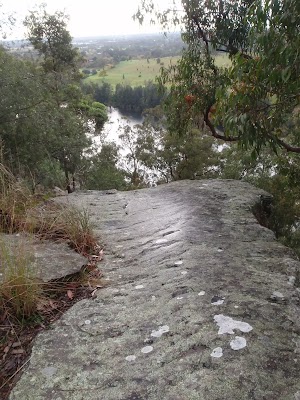
This informal and unfenced view point is just below Lapstone Station. There are stunning views up and down the Nepean River and across some farmland on the Cumberland Plain. A great spot to enjoy the views.
(18.59km) Int. Tunnel Gully trk and car wreck trk → Int. Station trk and Tunnel Gully trk
120 m
2 mins
5m
0m
Moderate track
Continue straight: From the intersection, the track leads up the hill, keeping the car wreck behind on the right. The track undulates a little to an intersection below the train station.
(18.71km) Int. Station trk and Tunnel Gully trk → Platform 2 Lapstone Station
50 m
1 mins
7m
0m
Moderate track
Turn left : From the intersection, the track heads up the hill to the train station.
Lapstone
The historic town of Lapstone is the eastern-most town in the Blue Mountains. The small township has a railway station, which is shares with the bordering town of Leonay. The station offers a public telephone and toilet. There are no commercial facilities in the area. The name ‘Lapstone’ is said to have come from the ‘many water-worn stones in the area’, which resemble the lapstone used by cobblers when making shoes.
Maps for the Glenbrook to Lapstone via Euroka walk
You can download the PDF for this walk to print a map.
These maps below cover the walk and the wider area around the walk, they are worth carrying for safety reasons.
| Penrith | 1:25 000 Map Series | 90303N PENRITH | NSW-90303N |
| Penrith | 1:100 000 Map Series | 9030 PENRITH | 9030 |
Cross sectional view of the Glenbrook to Lapstone via Euroka bushwalking track
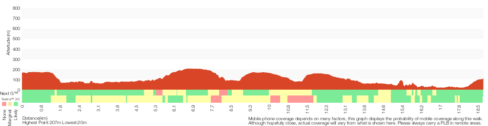
Analysis and summary of the altitude variation on the Glenbrook to Lapstone via Euroka
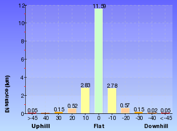
Daily actual walking time estimates
| Day | Walking Time | Length |
|---|---|---|
| 1 | 4 hrs 15 mins | 11.4 km |
| 2 | 3 hrs 28 mins | 7.8 km |
Overview of this walks grade – based on the AS 2156.1 – 2001
Under this standard, a walk is graded based on the most difficult section of the walk.
| Length | 18.8 km | ||
| Time | 2 Days | ||
| . | |||
| Grade 6/6 Very experienced only |
AS 2156.1 | Gradient | Very steep (4/6) |
| Quality of track | Off track (no visible track at times) (6/6) | ||
| Signs | No directional signs (5/6) | ||
| Experience Required | Moderate level of bushwalking experience recommended (4/6) | ||
| Weather | Storms may impact on navigation and safety (3/6) | ||
| Infrastructure | No facilities provided (5/6) |
Some more details of this walks Grading
Here is a bit more details explaining grading looking at sections of the walk
Gradient
9km of this walk has short steep hills and another 8km is very steep. Whilst another 2.2km has gentle hills with occasional steps and the remaining 25m is flat with no steps.
Quality of track
9km of this walk follows a formed track, with some branches and other obstacles and another 4.4km follows a rough track, where fallen trees and other obstacles are likely. Whilst another 2km follows a clear and well formed track or trail and a 2km section follows a known route where there is no visible track. The remaining 1.6km follows a smooth and hardened path.
Signs
8km of this walk has directional signs at most intersection and another 4.5km is clearly signposted. Whilst another 3.4km has minimal directional signs and the remaining 2.7km Has no directional signs.
Experience Required
13km of this walk requires no previous bushwalking experience and another 4.3km requires some bushwalking experience. The remaining (1km) requires a leader a with moderate level of bushwalking experience.
weather
Around 16km of this walk is not usually affected by severe weather events (that would unexpectedly impact safety and navigation), whilst the remaining 3.1km is affected by storms that may impact your navigation and safety.
Infrastructure
9km of this walk is close to useful facilities (such as fenced cliffs and seats) and another 4.2km has limited facilities (such as not all cliffs fenced). Whilst another 3.2km has limited facilities (such as cliffs not fenced, significant creeks not bridged) and the remaining 2.7km has no facilities provided.
Similar walks
A list of walks that share part of the track with the Glenbrook to Lapstone via Euroka walk.
522 m Return
20 mins
Hard track
756 m Return
30 mins
Hard track
1 km Return
30 mins
Moderate track
1.7 km Return
1 hr 30 mins
Hard track
2.5 km Return
1 hr 15 mins
Hard track
3.2 km Return
1 hr 30 mins
Hard track
4.1 km Circuit
2 hrs
Moderate track
4.3 km One way
1 hr 45 mins
Experienced only
4.4 km One way
2 hrs
Hard track
8.3 km Circuit
3 hrs 45 mins
Hard track
8.4 km Circuit
3 hrs 45 mins
Experienced only
16.6 km Circuit
2 Days
Experienced only
29.6 km One way
3 Days
Hard track
Other Nearby walks
A list of walks that start near the Glenbrook to Lapstone via Euroka walk.
1 km Return
45 mins
Moderate track
1.4 km Return
1 Hr
Moderate track
2 km Circuit
1 Hr
Hard track
218 m Return
20 mins
Moderate track
512 m Return
30 mins
Hard track
74 m Return
10 mins
Very easy
2.8 km Circuit
1 hr 15 mins
Hard track
4.3 km Circuit
2 hrs 30 mins
Hard track
4 km Return
2 hrs
Hard track
6 km One way
3 hrs
Hard track
2.6 km Circuit
1 hr 30 mins
Hard track
2.9 km One way
2 hrs
Hard track
Plan your trip to and from the walk here
The Glenbrook to Lapstone via Euroka walk starts at the Glenbrook Station (gps: -33.76894, 150.62134)
Your transport options to Glenbrook Station are by;
![]() Train. (get details)
Train. (get details)
![]() Bus. (get details)
Bus. (get details)
![]() Car. There is free parking available.
Car. There is free parking available.
(get details)
The Glenbrook to Lapstone via Euroka ends at the Platform 2 Lapstone Station (gps: -33.773274, 150.64281)
Your transport options to Platform 2 Lapstone Station are by;
![]() Train. (get details)
Train. (get details)
![]() Bus. (get details)
Bus. (get details)
![]() Car. There is free parking available.
Car. There is free parking available.
(get details)
Short URL = http://wild.tl/gtls
Gallery images
There are other downloads I am still working on.
You will probably need to login to access these — still all free.
* KML (google earth file)
* GPX (GPS file)
Special Maps/ brochures
* A3 topo maps
* PDF with Lands Topo map base
* PDF with arial image (and map overlay)
I wanted to get the main site live first, this extra stuff will come in time.
Happy walking
Matt 🙂
Nepean Lookout
And Walk
Nepean Lookout

30 mins
1.3 km Return
41 m
Moderate track
This walk is along the old road, which is now a management trail, making navigation easy. The walk brings you to the top of the Nepean Gorge escarpment, with great views up and down the gorge. This is a short walk after a fairly long drive, but if you are in the area, it is well worth getting the car dirty. The lookout is not fenced.
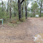
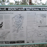
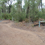
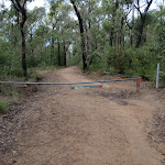
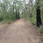

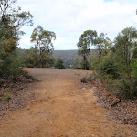

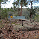


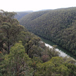
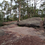

(0km) Car park at end of Nepean Lookout fire trail → Nepean Lookout
630 m
12 mins
1m
-40m
Moderate track
From the car park at then end of the Nepean Lookout fire trail, this walk follows the ‘Nepean Lookout 500m’ sign around the gate and along the management trail. The trail gently heads down the hill to a large clearing. The view of the Nepean and the surrounding area is found from the top of the unfenced rock platforms. just beyond the clearing.
Nepean Lookout
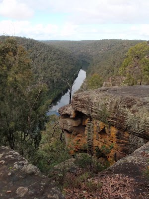
Nepean Lookout, is found past the locked gate at the end of the Nepean Lookout fire trail. The lookout is high above the junction of Erskine Creek (not visible) and the Nepean River. The unfenced lookout, is on a rocky cliff top forming the western wall of the Nepean Gorge. The view south up the Nepean Gorge are great, the views downstream are good, but limited.
Maps for the Nepean Lookout walk
You can download the PDF for this walk to print a map.
These maps below cover the walk and the wider area around the walk, they are worth carrying for safety reasons.
| Penrith | 1:25 000 Map Series | 90303N PENRITH | NSW-90303N |
| Penrith | 1:100 000 Map Series | 9030 PENRITH | 9030 |
Cross sectional view of the Nepean Lookout bushwalking track
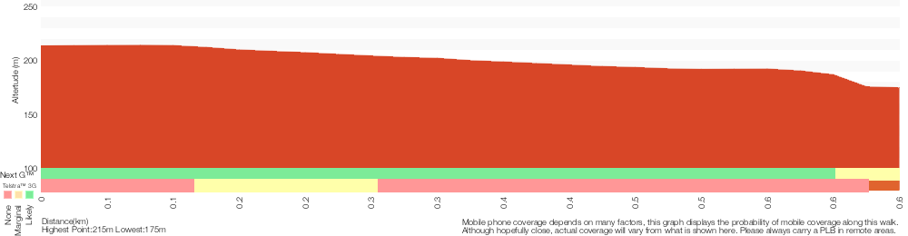
Analysis and summary of the altitude variation on the Nepean Lookout
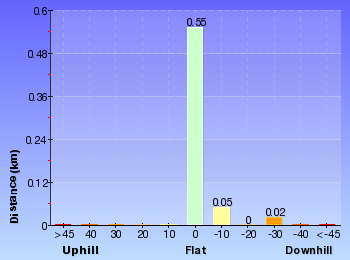
Overview of this walks grade – based on the AS 2156.1 – 2001
Under this standard, a walk is graded based on the most difficult section of the walk.
| Length | 1.3 km | ||
| Time | 30 mins | ||
| . | |||
| Grade 3/6 Moderate track |
AS 2156.1 | Gradient | Gentle hills with occasional steps (2/6) |
| Quality of track | Clear and well formed track or trail (2/6) | ||
| Signs | Clearly signposted (1/6) | ||
| Experience Required | No experience required (1/6) | ||
| Weather | Weather generally has little impact on safety (1/6) | ||
| Infrastructure | Limited facilities, not all cliffs are fenced (3/6) |
Some more details of this walks Grading
Here is a bit more details explaining grading looking at sections of the walk
Gradient
This whole walk, 630m has gentle hills with occasional steps.
Quality of track
This whole walk, 630m follows a clear and well formed track or trail.
Signs
This whole walk, 630m is clearly signposted.
Experience Required
This whole walk, 630m requires no previous bushwalking experience.
weather
This whole walk, 630m is not usually affected by severe weather events (that would unexpectedly impact safety and navigation).
Infrastructure
This whole walk, 630m has limited facilities (such as not all cliffs fenced).
Similar walks
A list of walks that share part of the track with the Nepean Lookout walk.
Other Nearby walks
A list of walks that start near the Nepean Lookout walk.
648 m Return
20 mins
Moderate track
2.6 km Return
2 hrs
Experienced only
466 m Return
15 mins
Moderate track
2 km Return
1 Hr
Experienced only
6 km Return
4 hrs
Very experienced only
10.3 km Circuit
2 Days
Very experienced only
2.8 km Return
3 hrs
Very experienced only
7.1 km Circuit
4 hrs 30 mins
Very experienced only
1.6 km Return
45 mins
Moderate track
18.1 km One way
7 hrs
Hard track
4.3 km One way
1 hr 45 mins
Experienced only
2.8 km Circuit
1 hr 15 mins
Hard track
Plan your trip to and from the walk here
The Nepean Lookout walk starts and ends at the Car park at end of Nepean Lookout fire trail (gps: -33.840335, 150.58146)
Your main transport option to Car park at end of Nepean Lookout fire trail is by;
![]() Car. A park entry fee is required for driving into the park.
Car. A park entry fee is required for driving into the park.
(get details)
Short URL = http://wild.tl/nlot
Gallery images
There are other downloads I am still working on.
You will probably need to login to access these — still all free.
* KML (google earth file)
* GPX (GPS file)
Special Maps/ brochures
* A3 topo maps
* PDF with Lands Topo map base
* PDF with arial image (and map overlay)
I wanted to get the main site live first, this extra stuff will come in time.
Happy walking
Matt 🙂
Comments