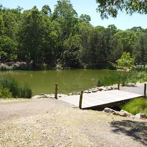
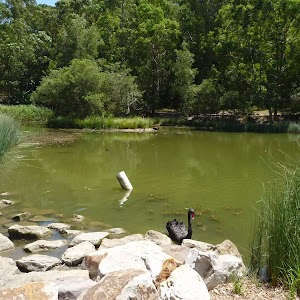
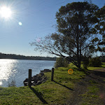
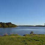
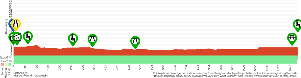
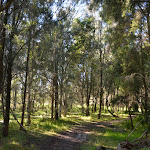
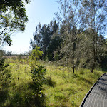
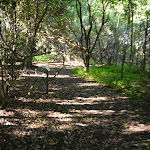
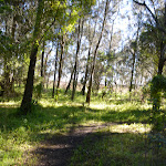
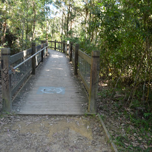
Wander among the mangroves to step back in time to explore the old Schoolmaster’s House that was part of a once vibrant community in the area. Following devastating floods in 1955, the people moved from the area with the area still being leased as farmland. Now, these wetlands are protected as part of the national park ensuring the survival of the endangered ecological community of saltmarsh and all the fish, birds and other animals that rely on them for survival. Bring a picnic lunch and settle under a tree or bring binoculars and a bird guide. Take your time to enjoy all this area has on offer.
Mangrove Boardwalk to Schoolmasters House


30 mins
1.2 km Return

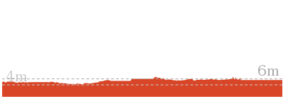
4 m
Very easy


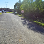
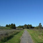
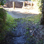
(0km) Mangrove Boardwalk car park → Boardwalk seating area

350 m
5 mins
0m
0m
Very easy
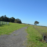
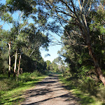
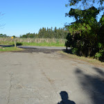
From the Mangrove Boardwalk car park

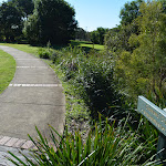
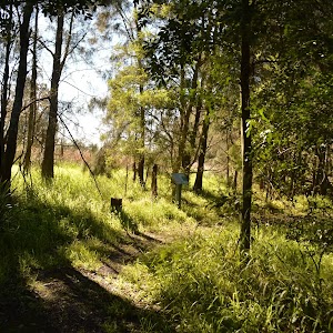
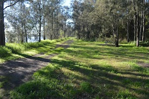
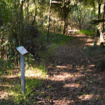
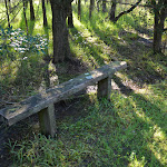
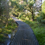
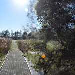
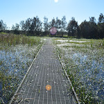
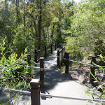
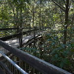
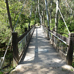
[1] on Millams Rd Kooragang, (with the large ‘Welcome to Kooragang Wetlands’ sign[2]) this walk follows the ‘Mangrove Boardwalk’ arrow[3] along the timber boardwalk directly away from the road. This walk gently meanders along the boardwalk for about 80m to cross a bridge with (90cm high) hand railings[4], to come to a seat

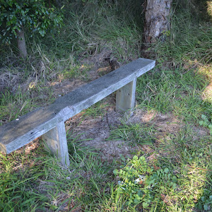
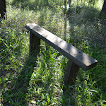
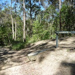
about 50m later. This walk then continues for the next 160m, passing a few information signs[5][6][7] to find another seat

. The walk continues along the boardwalk through the open wetlands for another 60m to come to a third seat

(on the left).
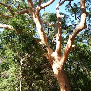
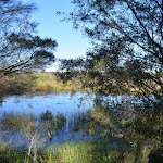
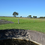
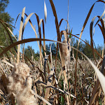
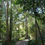
Mangroves

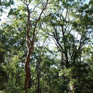
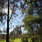
Mangroves are a type of resistant, salt tolerant and pretty cool tree. They are are a type of halophyte, a plant that grows in salty water. They are perfectly adapted for life in harsh coastal conditions and salt marshes like this one. The plants contain systems to manage the salt levels and root system to anchor in different areas from deep mud to rocky coastlines. The roots also have aerial shoots to help deal with the particular low oxygen levels of mud. The mangroves are great and environmentaly critical to the survival of many animals like crabs and birds.
(0.35km) Boardwalk seating area → Mangrove Boardwalk int.
190 m
3 mins
2m
-2m
Very easy
(0.54km) Mangrove Boardwalk int. → Cobbans Track int.
160 m
2 mins
1m
-1m
Very easy
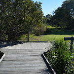
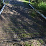
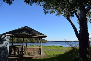
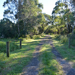
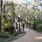
Turn right: From the intersection, this walk follows ‘Cobbans Creek’ arrow sign[14] along the timber boardwalk keeping the open area to the left. After about 40m the boardwalk ends and this walk heads along an asphalt path[15], for about 10m to a seat

and the ‘Sue’s Garden’ sign[16] (both on the left). From here this walk continues along the asphalt path for about 110m, passing two more seats


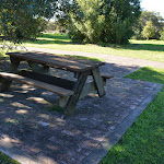
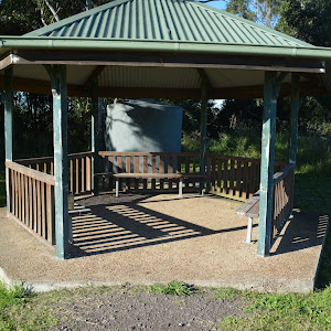
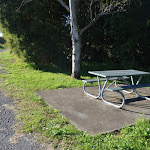
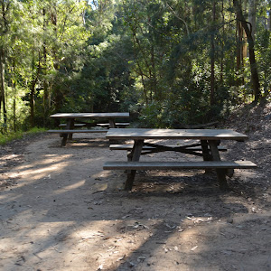
and a picnic table

(on the left) to cross a short timber bridge and come to the Cobbans Track T-intersection[17], marked by the ‘Cobbans Creek’ sign[18]. At the end of this side trip, retrace your steps back to the main walk then Turn right.
(0.54km) Mangrove Boardwalk int. → Schoolmasters House
60 m
1 mins
0m
0m
Very easy
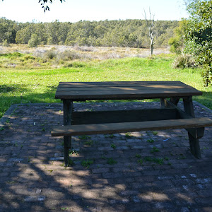
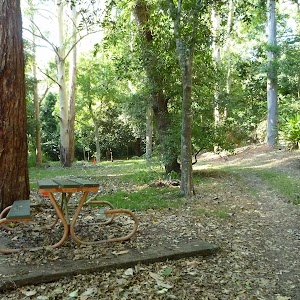
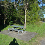
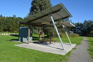
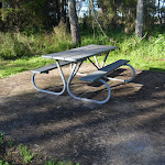
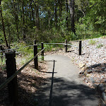
Veer left: From the intersection, this walk follows ‘schoolmasters house’ sign[19] gently uphill along the concrete path[20]. After about 20m the path leads past a picnic table

(on the left) and continues for about 30m to come to the front of the ‘School Masters House’[21] (on the right). Access to the old school house is either via smaller steps[22] or around the far side by heading through the car park where there are a few picnic tables

.
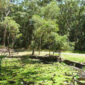
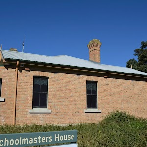
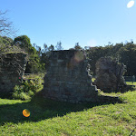
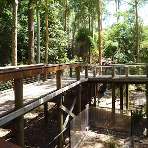
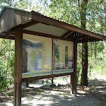
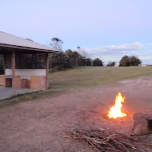
Schoolmasters House
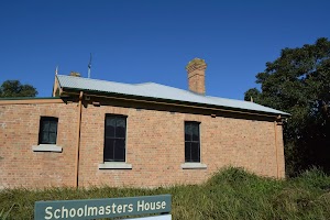
The schoolmaster’s house building is now used as the Kooragang Wetlands Information Centre. The building is open to the public (phone 02-4964 9308), with some interesting displays. In 1955 there were over 50 families and this school in the area, when the island was devastated by a massive flood. Following the flood, the area then was taken under state control and was leased for grazing. The school opened in 1873 and closed in 1968.
There are two main entrances. The back entrance has 3 14cm steps to get inside[26]. More info.
There are two main entrances. The back entrance has 3 14cm steps to get inside[26]. More info.
Maps for the Mangrove Boardwalk to Schoolmasters House walk
You can download the PDF for this walk to print a map.
These maps below cover the walk and the wider area around the walk, they are worth carrying for safety reasons.
| Beresfield | 1:25 000 Map Series | 92323N BERESFIELD | NSW-92323N |
| Newcastle | 1:100 000 Map Series | 9232 NEWCASTLE | 9232 |
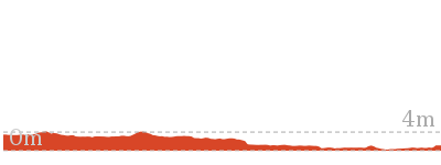
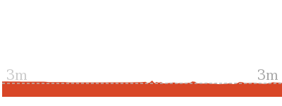
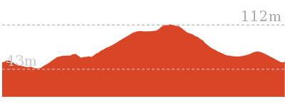
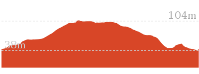
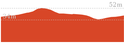
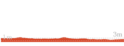
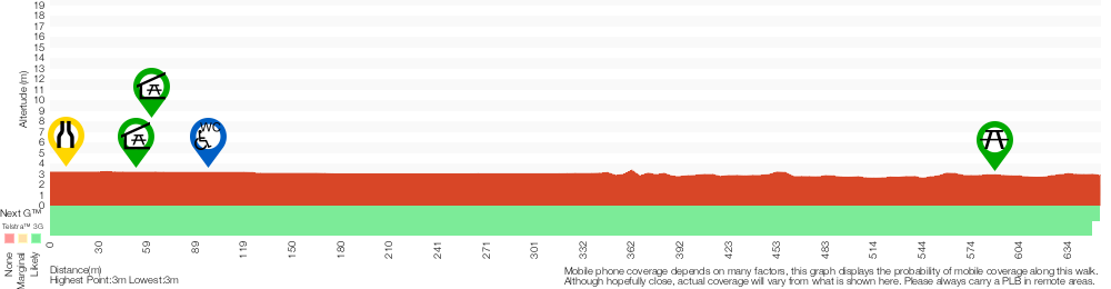
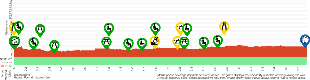
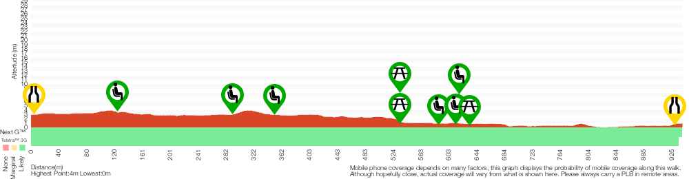
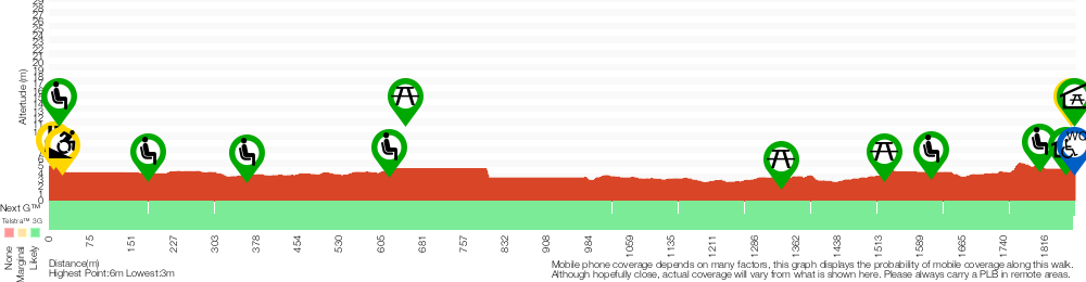
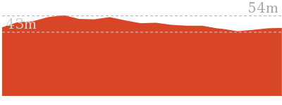
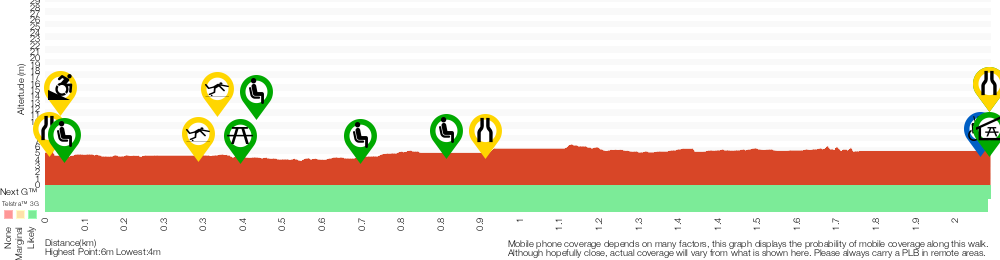
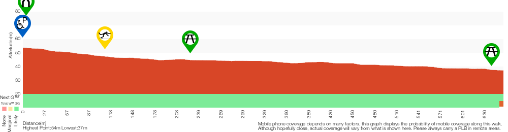
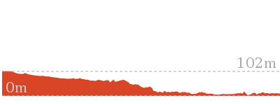
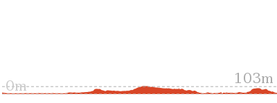
Cross sectional view of the Mangrove Boardwalk to Schoolmasters House bushwalking track
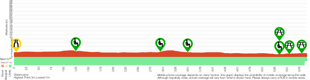
Analysis and summary of the altitude variation on the Mangrove Boardwalk to Schoolmasters House

Accessibility summary information for the Mangrove Boardwalk to Schoolmasters House
Parking: There are 0 designated accessible parking areas on this walk.
Toilets: There are 0 designated accessible toilets on this walk.
Seats: There are 5 places to sit on this walk.
They are on average 150m apart, with a maximum gap of 210m.
Hazards: There are 0 specific noteable accessability related hazards on this walk.
Accessibility Details


Found 540m into this walk

Found 560m into this walk

Found 580m into this walk
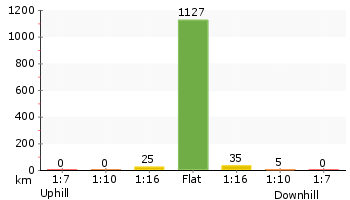
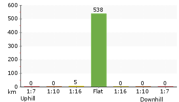
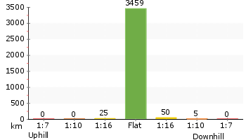
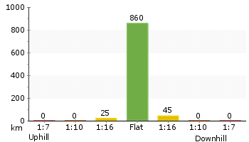
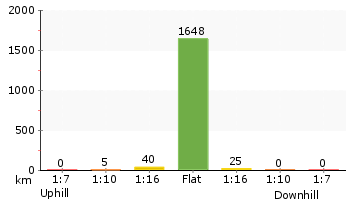
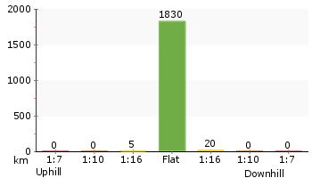
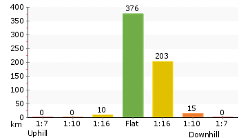
Overview of this walks grade – based on the AS 2156.1 – 2001
Under this standard, a walk is graded based on the most difficult section of the walk.
| Length | 1.2 km | ||
| Time | 30 mins | ||
| . | |||
| Grade 1/6 Very easy |
AS 2156.1 | Gradient | Flat, no steps (1/6) |
| Quality of track | Smooth and hardened path (1/6) | ||
| Signs | Clearly signposted (1/6) | ||
| Experience Required | No experience required (1/6) | ||
| Weather | Weather generally has little impact on safety (1/6) | ||
| Infrastructure | Generally useful facilities (such as fenced cliffs and seats) (1/6) |
Some more details of this walks Grading
Here is a bit more details explaining grading looking at sections of the walk
Gradient
This whole walk, 590m is flat with no steps.
Quality of track
This whole walk, 590m follows a smooth and hardened path.
Signs
This whole walk, 590m is clearly signposted.
Experience Required
This whole walk, 590m requires no previous bushwalking experience.
weather
This whole walk, 590m is not usually affected by severe weather events (that would unexpectedly impact safety and navigation).
Infrastructure
This whole walk, 590m is close to useful facilities (such as fenced cliffs and seats).
Similar walks
A list of walks that share part of the track with the Mangrove Boardwalk to Schoolmasters House walk.
945 m One way
30 mins
Easy track
Other Nearby walks
A list of walks that start near the Mangrove Boardwalk to Schoolmasters House walk.
2 km One way
45 mins
Moderate track
1.9 km One way
45 mins
Easy track
1.3 km Return
30 mins
Easy track

2.5 km Return
45 mins
Easy track

3.9 km Circuit
1 hr 15 mins
Moderate track
2.7 km Circuit
1 Hr
Moderate track
6.5 km Circuit
2 hrs 30 mins
Moderate track
2.8 km Circuit
1 hr 15 mins
Moderate track
2.9 km Circuit
1 hr 15 mins
Moderate track

6 km Circuit
2 hrs 30 mins
Moderate track
731 m Circuit
30 mins
Very easy
1.9 km Circuit
1 Hr
Moderate track
Plan your trip to and from the walk here
The Mangrove Boardwalk to Schoolmasters House walk starts and ends at the Mangrove Boardwalk car park (gps: -32.844726, 151.69741)
Your main transport option to Mangrove Boardwalk car park is by;
![]() Car. There is free parking available.
Car. There is free parking available.
(get details)


Short URL = http://wild.tl/mbtsh
Gallery images
There are other downloads I am still working on.
You will probably need to login to access these — still all free.
* KML (google earth file)
* GPX (GPS file)
Special Maps/ brochures
* A3 topo maps
* PDF with Lands Topo map base
* PDF with arial image (and map overlay)
I wanted to get the main site live first, this extra stuff will come in time.
Happy walking
Matt 🙂
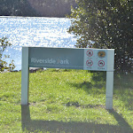
Riverside Park to Scotts Point
And Walk
Riverside Park to Scotts Point

45 mins
2.5 km Return
0 m
Easy track
Explore the bank of the north arm of the Hunter River by following an old road from one picnic area to another. Starting from the well established Riverside Park picnic area, you wander along the mostly flat walk following the asphalt and gravel trail along the banks of the river, through a She Oak forest and beside the wetlands. A great walk for enjoying the birdlife and varied forest along the way. There are a series of picnic tables along the way and a sheltered seating area at Scotts Point. Once you are ready, retrace your steps back to the car.


(0km) Riverside Park car park → Riverside Park car park int
20 m
0m
0m
Easy track

(0.02km) Riverside Park car park int → City Farm jetty
100 m
1 mins
0m
-1m
Easy track
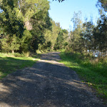
Turn right: From the intersection, this walk follows the gravel track to cross the short fibreglass bridge, keeping the river to the left. After about 10m this walk comes to a 3-way intersection with a gravel footpath, marked by an arrow post sign[4].
Continue straight: From the intersection, this walk follows the ‘Jetty’ arrow[5] along the gravel path[6] keeping the river to the left. After about 40m the path leads past a sheltered picnic area
Continue straight: From the intersection, this walk follows the ‘Jetty’ arrow[5] along the gravel path[6] keeping the river to the left. After about 40m the path leads past a sheltered picnic area

and water tap

(on the right) then continues for about 30m to come to a ‘Hunter Wetlands National Park’ information sign[7] (on the right). Here the walk leads onto the floating jetty ramp[8] with 1m metal fence that leads to the City Farm jetty[9] (there is an 8cm step[10] to access the actual jetty platform[11]. At the end of this side trip, retrace your steps back to the main walk then Continue straight.
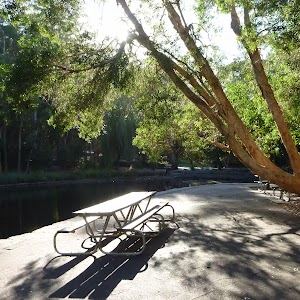
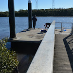
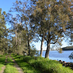
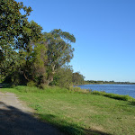
Riverside Park
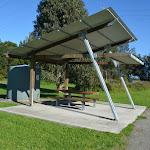
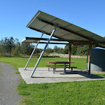
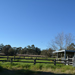
Riverside Park is found near the end of ‘The Lane’, Kooragang within Hunter Wetlands National Park. There is the City Farm jetty[12] on the banks of the north arm of the Hunter River[13]. You will also find two picnic shelters[14]

, each with a water tank

. There is also an accessible toilet[15]

at the back of the grassy area. There are a few walks that leave from the area and it is also a popular fishing and bird watching area.
(0.02km) Riverside Park car park int → Mid way pincic area
530 m
8 mins
0m
0m
Easy track
Turn left : From the intersection, this walk leads over the grassy section[16] between the car park and river, keeping the river to the right. At the far end of the car park the walk leads past the stone seats

then follows the ‘Scotts Point’ arrow[17] under the power lines, turning right at the intersection and following the asphalt trail for about 210m to pass a timber seat

(on the left). The walk continues along the trail for another 90m to pass a single picnic table

. The walk continues along the trail beside the river for another 180m to find the mid way picnic area with 2 picnic tables

Mid way pincic area
This relaxed picnic area is found on the banks of the north arm of the Hunter River nestled among She Oaks[20] and the wetlands. There are two picnic tables[21][22]
on concrete slabs beside the trail. The grassy area around the tables can become boggy[23] after rain or very high tides. A pleasant naturally shaded area with some protection from light winds.
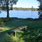
(0.55km) Mid way pincic area → Scotts Point
700 m
11 mins
0m
0m
Easy track
Continue straight: From the picnic area, this walk follows the old road over the 2.7m wide timber bridge[24], keeping the river to the right. Over the next 200m the walk leads past a series of large orange triangle boat navigation markers[25] with lovely views over the river[26]. The walk continues along the old road for another 250m to pass a ‘Scotts Point Way’ sign[27] where there are more views of the wetlands[28] (to the left) The walk continues for another 220m to come to the open grassy area and Scotts Point picnic area, marked with 3 signs[29] (close to the water on the right), a picnic table

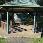
(on the left) and a sheltered sitting area

with a water tap

. There are beautiful views of the confluence of two water ways with a view across a shipping area and a bridge and distant views of the mountains.
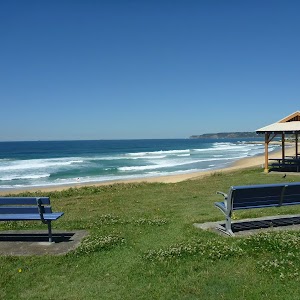
Scotts Point
Scotts Point is home to a water tank
, picnic table
and seating shelter
beside an open grassy area at the confluence of the north and south arms of the Hunter River[30]. There are views down the river to Hexham bridge and past some shipping areas[31]. There are a series of signs [32][33][34] to explain more about the local area. This is a lovely spot to rest and enjoy the river and the wetlands.
Maps for the Riverside Park to Scotts Point walk
You can download the PDF for this walk to print a map.
These maps below cover the walk and the wider area around the walk, they are worth carrying for safety reasons.
| Beresfield | 1:25 000 Map Series | 92323N BERESFIELD | NSW-92323N |
| Newcastle | 1:100 000 Map Series | 9232 NEWCASTLE | 9232 |
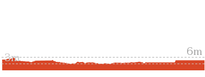
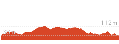
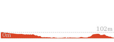
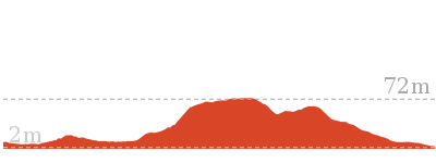
Cross sectional view of the Riverside Park to Scotts Point bushwalking track
Analysis and summary of the altitude variation on the Riverside Park to Scotts Point
Accessibility summary information for the Riverside Park to Scotts Point
Parking: There are 0 designated accessible parking areas on this walk.
Toilets: There are 0 designated accessible toilets on this walk.
Seats: There are 6 places to sit on this walk.
They are on average 250m apart, with a maximum gap of 690m.
Hazards: There are 0 specific noteable accessability related hazards on this walk.
Accessibility Details

Found 0m into this walk


Found 20m into this walk


Found 350m into this walk

Found 530m into this walk

Found 1220m into this walk

Found 1240m into this walk
Found 1240m into this walk
Overview of this walks grade – based on the AS 2156.1 – 2001
Under this standard, a walk is graded based on the most difficult section of the walk.
| Length | 2.5 km | ||
| Time | 45 mins | ||
| . | |||
| Grade 2/6 Easy track |
AS 2156.1 | Gradient | Gentle hills with occasional steps (2/6) |
| Quality of track | Clear and well formed track or trail (2/6) | ||
| Signs | Clearly signposted (1/6) | ||
| Experience Required | No experience required (1/6) | ||
| Weather | Weather generally has little impact on safety (1/6) | ||
| Infrastructure | Generally useful facilities (such as fenced cliffs and seats) (1/6) |
Some more details of this walks Grading
Here is a bit more details explaining grading looking at sections of the walk
Gradient
Around 720m of this walk is flat with no steps, whilst the remaining 530m has gentle hills with occasional steps.
Quality of track
This whole walk, 1.2km follows a clear and well formed track or trail.
Signs
This whole walk, 1.2km is clearly signposted.
Experience Required
This whole walk, 1.2km requires no previous bushwalking experience.
weather
This whole walk, 1.2km is not usually affected by severe weather events (that would unexpectedly impact safety and navigation).
Infrastructure
This whole walk, 1.2km is close to useful facilities (such as fenced cliffs and seats).
Similar walks
A list of walks that share part of the track with the Riverside Park to Scotts Point walk.
1.3 km Return
30 mins
Easy track
1.9 km One way
45 mins
Easy track
2 km One way
45 mins
Moderate track
3.9 km Circuit
1 hr 15 mins
Moderate track
Other Nearby walks
A list of walks that start near the Riverside Park to Scotts Point walk.
1.2 km Return
30 mins
Very easy
945 m One way
30 mins
Easy track
2.7 km Circuit
1 Hr
Moderate track
2.9 km Circuit
1 hr 15 mins
Moderate track
6.5 km Circuit
2 hrs 30 mins
Moderate track
2.8 km Circuit
1 hr 15 mins
Moderate track
6 km Circuit
2 hrs 30 mins
Moderate track
731 m Circuit
30 mins
Very easy
2.1 km Circuit
1 Hr
Moderate track
1.9 km Circuit
1 Hr
Moderate track
2.5 km Circuit
1 Hr
Moderate track
2 km Circuit
1 Hr
Moderate track
Plan your trip to and from the walk here
The Riverside Park to Scotts Point walk starts and ends at the Riverside Park car park (gps: -32.833948, 151.70896)
Your main transport option to Riverside Park car park is by;
![]() Car. There is free parking available.
Car. There is free parking available.
(get details)
Short URL = http://wild.tl/rptsp
Gallery images
There are other downloads I am still working on.
You will probably need to login to access these — still all free.
* KML (google earth file)
* GPX (GPS file)
Special Maps/ brochures
* A3 topo maps
* PDF with Lands Topo map base
* PDF with arial image (and map overlay)
I wanted to get the main site live first, this extra stuff will come in time.
Happy walking
Matt 🙂
City Farm walk to Milhams Farmhouse Ruin

30 mins
1.3 km Return
0 m
Easy track
Step back in time on this short easy walk that guides you from Riverside Park picnic area to the ruins of the Milham’s family farmhouse. The farm was once a vibrant dairy and today you will still see cattle grazing in the fenced paddocks alongside the walk. From the banks of the north arm of the Hunter River, this walk follows the old farm road (closed to traffic) alongside the paddocks and she oak forest. There is a picnic table in the shade near the old house, a nice quiet spot to sit and reminisce on the rich history and natural beauty of the area.


(0km) Riverside Park car park → Riverside Park int
30 m
0m
0m
Easy track
From the Riverside Park car park[1] at the end of The Lane, Kooragang, this walk heads over the grassy and gravel area through timber bollards
[2] for less than 10m to come to an intersection just before the river, marked by a ‘Riverside Park’ sign[3].
Turn right: From the intersection, this walk follows the gravel track to cross the short fibreglass bridge, keeping the river to the left. After about 10m this walk comes to a 3-way intersection with a gravel footpath, marked by an arrow post sign[4].
Riverside Park
Riverside Park is found near the end of ‘The Lane’, Kooragang within Hunter Wetlands National Park. There is the City Farm jetty[5] on the banks of the north arm of the Hunter River[6]. You will also find two picnic shelters[7]
, each with a water tank
. There is also an accessible toilet[8]
at the back of the grassy area. There are a few walks that leave from the area and it is also a popular fishing and bird watching area.
(0.03km) Riverside Park int → City Farm jetty
90 m
1 mins
0m
-1m
Easy track
Continue straight: From the intersection, this walk follows the ‘Jetty’ arrow[9] along the gravel path[10] keeping the river to the left. After about 40m the path leads past a sheltered picnic area
and water tap
(on the right) then continues for about 30m to come to a ‘Hunter Wetlands National Park’ information sign[11] (on the right). Here the walk leads onto the floating jetty ramp[12] with 1m metal fence that leads to the City Farm jetty[13] (there is an 8cm step[14] to access the actual jetty platform[15]. At the end of this side trip, retrace your steps back to the main walk then Turn left.
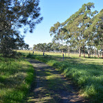
(0.03km) Riverside Park int → City Farm ruins
630 m
9 mins
0m
0m
Easy track
Turn right: From the intersection, this walk follows the ‘City Farm’ [16] arrow along the gravel path heading directly away from the river. After about 20m this walk leads past a picnic table (on the left) and then sheltered picnic area
and water tap
(on the right). About 30m later this walk leads past the track leading to the toilet
(on the left). This walk continues straight on, as the track widens, for about 25m to cross over a small bridge[17] where the trail then bends left[18]. Here the mostly flat trail leads alongside the farmland for 400m to then bend right through a gap in the fence and come to a picnic table

(on the right). The walk continues along the trail for another 60m as in bends left to come to the front of The City Farm ruins marked with a ‘Riverside park’ sign point back[19].
City Farm ruins
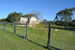
The ruins are a part of the City Farm precinct and are specifically the Milham’s farmhouse ruins. The home was built in the 1860s from sandstone quarried from Muree, then transported by bullock dray, then by river. Seashells were commonly used to produce lime in the mortar at the time . The farm was primarily a dairy farm and there are still ruins of the well[21] and milking sheds east of the house.
Maps for the City Farm walk to Milhams Farmhouse Ruin walk
You can download the PDF for this walk to print a map.
These maps below cover the walk and the wider area around the walk, they are worth carrying for safety reasons.
| Beresfield | 1:25 000 Map Series | 92323N BERESFIELD | NSW-92323N |
| Newcastle | 1:100 000 Map Series | 9232 NEWCASTLE | 9232 |
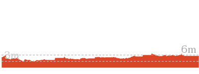
Cross sectional view of the City Farm walk to Milhams Farmhouse Ruin bushwalking track
Analysis and summary of the altitude variation on the City Farm walk to Milhams Farmhouse Ruin
Accessibility summary information for the City Farm walk to Milhams Farmhouse Ruin
Parking: There are 0 designated accessible parking areas on this walk.
Toilets: There are 1 designated accessible toilets on this walk.
Seats: There are 3 places to sit on this walk.
They are on average 300m apart, with a maximum gap of 530m.
Hazards: There are 0 specific noteable accessability related hazards on this walk.
Accessibility Details
Found 50m into this walk
Found 60m into this walk

Found 590m into this walk
Overview of this walks grade – based on the AS 2156.1 – 2001
Under this standard, a walk is graded based on the most difficult section of the walk.
| Length | 1.3 km | ||
| Time | 30 mins | ||
| . | |||
| Grade 2/6 Easy track |
AS 2156.1 | Gradient | Gentle hills with occasional steps (2/6) |
| Quality of track | Clear and well formed track or trail (2/6) | ||
| Signs | Clearly signposted (1/6) | ||
| Experience Required | No experience required (1/6) | ||
| Weather | Weather generally has little impact on safety (1/6) | ||
| Infrastructure | Generally useful facilities (such as fenced cliffs and seats) (1/6) |
Some more details of this walks Grading
Here is a bit more details explaining grading looking at sections of the walk
Gradient
Around 630m of this walk has gentle hills with occasional steps, whilst the remaining 30m is flat with no steps.
Quality of track
Around 640m of this walk follows a clear and well formed track or trail, whilst the remaining 15m follows a smooth and hardened path.
Signs
This whole walk, 660m is clearly signposted.
Experience Required
This whole walk, 660m requires no previous bushwalking experience.
weather
This whole walk, 660m is not usually affected by severe weather events (that would unexpectedly impact safety and navigation).
Infrastructure
This whole walk, 660m is close to useful facilities (such as fenced cliffs and seats).
Similar walks
A list of walks that share part of the track with the City Farm walk to Milhams Farmhouse Ruin walk.
1.9 km One way
45 mins
Easy track
2 km One way
45 mins
Moderate track
2.5 km Return
45 mins
Easy track
3.9 km Circuit
1 hr 15 mins
Moderate track
Other Nearby walks
A list of walks that start near the City Farm walk to Milhams Farmhouse Ruin walk.
1.2 km Return
30 mins
Very easy
945 m One way
30 mins
Easy track
2.7 km Circuit
1 Hr
Moderate track
2.9 km Circuit
1 hr 15 mins
Moderate track
6.5 km Circuit
2 hrs 30 mins
Moderate track
2.8 km Circuit
1 hr 15 mins
Moderate track
6 km Circuit
2 hrs 30 mins
Moderate track
731 m Circuit
30 mins
Very easy
2.1 km Circuit
1 Hr
Moderate track
1.9 km Circuit
1 Hr
Moderate track
2.5 km Circuit
1 Hr
Moderate track
2 km Circuit
1 Hr
Moderate track
Plan your trip to and from the walk here
The City Farm walk to Milhams Farmhouse Ruin walk starts and ends at the Riverside Park car park (gps: -32.833948, 151.70896)
Your main transport option to Riverside Park car park is by;
![]() Car. There is free parking available.
Car. There is free parking available.
(get details)
Short URL = http://wild.tl/cfwtmfr
Gallery images
There are other downloads I am still working on.
You will probably need to login to access these — still all free.
* KML (google earth file)
* GPX (GPS file)
Special Maps/ brochures
* A3 topo maps
* PDF with Lands Topo map base
* PDF with arial image (and map overlay)
I wanted to get the main site live first, this extra stuff will come in time.
Happy walking
Matt 🙂
Scotts Point circuit
And Walk
Scotts Point circuit

1 hr 15 mins
3.9 km Circuit
0 m
Moderate track
This walk guides you around, then through the wetlands via Scott Point. You first walk along an old closed road on the banks of the Hunter River (north and south arms) then you meander along the lovely boardwalk through the heart of the wetlands then along the rainforest track to see a greater diversity of plants. You then return to the start by walking along a few roads giving you the sense of a stroll through rural farmlands. This lovely circuit walk gives you the sense of the variety of life in the precious ecosystem.


(0km) Riverside Park car park → Riverside Park car park int
20 m
0m
0m
Easy track
(0.02km) Riverside Park car park int → City Farm jetty
100 m
1 mins
0m
-1m
Easy track
Turn right: From the intersection, this walk follows the gravel track to cross the short fibreglass bridge, keeping the river to the left. After about 10m this walk comes to a 3-way intersection with a gravel footpath, marked by an arrow post sign[4].
Continue straight: From the intersection, this walk follows the ‘Jetty’ arrow[5] along the gravel path[6] keeping the river to the left. After about 40m the path leads past a sheltered picnic area
Continue straight: From the intersection, this walk follows the ‘Jetty’ arrow[5] along the gravel path[6] keeping the river to the left. After about 40m the path leads past a sheltered picnic area
and water tap
(on the right) then continues for about 30m to come to a ‘Hunter Wetlands National Park’ information sign[7] (on the right). Here the walk leads onto the floating jetty ramp[8] with 1m metal fence that leads to the City Farm jetty[9] (there is an 8cm step[10] to access the actual jetty platform[11]. At the end of this side trip, retrace your steps back to the main walk then Continue straight.
Riverside Park
Riverside Park is found near the end of ‘The Lane’, Kooragang within Hunter Wetlands National Park. There is the City Farm jetty[12] on the banks of the north arm of the Hunter River[13]. You will also find two picnic shelters[14]
, each with a water tank
. There is also an accessible toilet[15]
at the back of the grassy area. There are a few walks that leave from the area and it is also a popular fishing and bird watching area.
(0.02km) Riverside Park car park int → Mid way pincic area
530 m
8 mins
0m
0m
Easy track
Turn left : From the intersection, this walk leads over the grassy section[16] between the car park and river, keeping the river to the right. At the far end of the car park the walk leads past the stone seats
then follows the ‘Scotts Point’ arrow[17] under the power lines, turning right at the intersection and following the asphalt trail for about 210m to pass a timber seat
(on the left). The walk continues along the trail for another 90m to pass a single picnic table
. The walk continues along the trail beside the river for another 180m to find the mid way picnic area with 2 picnic tables
Mid way pincic area
This relaxed picnic area is found on the banks of the north arm of the Hunter River nestled among She Oaks[20] and the wetlands. There are two picnic tables[21][22]
on concrete slabs beside the trail. The grassy area around the tables can become boggy[23] after rain or very high tides. A pleasant naturally shaded area with some protection from light winds.
(0.55km) Mid way pincic area → Scotts Point
700 m
11 mins
0m
0m
Easy track
Continue straight: From the picnic area, this walk follows the old road over the 2.7m wide timber bridge[24], keeping the river to the right. Over the next 200m the walk leads past a series of large orange triangle boat navigation markers[25] with lovely views over the river[26]. The walk continues along the old road for another 250m to pass a ‘Scotts Point Way’ sign[27] where there are more views of the wetlands[28] (to the left) The walk continues for another 220m to come to the open grassy area and Scotts Point picnic area, marked with 3 signs[29] (close to the water on the right), a picnic table
(on the left) and a sheltered sitting area
with a water tap
. There are beautiful views of the confluence of two water ways with a view across a shipping area and a bridge and distant views of the mountains.
Scotts Point
Scotts Point is home to a water tank
, picnic table
and seating shelter
beside an open grassy area at the confluence of the north and south arms of the Hunter River[30]. There are views down the river to Hexham bridge and past some shipping areas[31]. There are a series of signs [32][33][34] to explain more about the local area. This is a lovely spot to rest and enjoy the river and the wetlands.
(1.25km) Scotts Point → Int of Scotts Point and Rainforest tracks
600 m
9 mins
0m
0m
Easy track
Continue straight: From Scotts Point picnic area
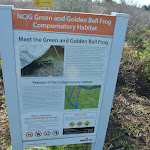
, this walk follows the gravel old road, keeping the river to the right[35]. This walk then gently meanders along the edge of the wetlands for about 170m to the ‘Green and Golden Bell Frog’ information sign[36] then 100m later lead past a small timber seat[37]

. The walk continues along the old road for another 180m to pass another small seat

the 150m later this walk comes to a 3-way intersection[38] marked by a sheltered sign[39] (on the right) and Scotts Point Way sign[40] (just before a locked gate).
(1.85km) Int of Scotts Point and Rainforest tracks → East end of Rainforest boardwalk
230 m
4 mins
0m
0m
Easy track
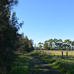
Turn left : From the intersection, this walk heads directly away from the river, following ‘The Silos’ arrow[41] down across the dip

and along the dirt track passing 3 seats

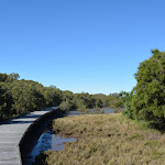
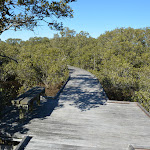
to find the fibreglass boardwalk[42]. This walk follows the boardwalk for 200m as it winds through the wetlands giving great views and bird watching opportunities to then come to the end of the raised boardwalk and start of a dirt track.
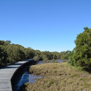
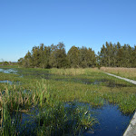
Rainforest boardwalk
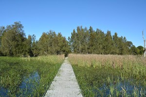
The boardwalk leads through the beautiful Kooragang Wetlands[43] giving great views of the water plants and birds. Specifically, this walk leads over the Water Ribbon Swale, an abandoned channel of the Hunter River. You might be lucky enough to see
Chestnut Teal, Great Egret, Cattle Egret, Glossy Ibis, Australian White Ibis, Straw-necked Ibis, Common Greenshank, Sharp-tailed Sandpiper, Curlew Sandpiper, or if very lucky a Painted Snipe.
Chestnut Teal, Great Egret, Cattle Egret, Glossy Ibis, Australian White Ibis, Straw-necked Ibis, Common Greenshank, Sharp-tailed Sandpiper, Curlew Sandpiper, or if very lucky a Painted Snipe.
(2.08km) East end of Rainforest boardwalk → Silos car park
700 m
10 mins
0m
0m
Moderate track
Continue straight: From the east end of Rainforest boardwalk, this walk heads along the grass and dirt track, away from the boardwalk for 160m passing through a few potentially boggy sections


to come to a picnic table

by the ‘Fallen Ash Grove’[54] (on the right). This walk continues along the track for another 35m to pass a small timber seat

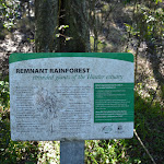
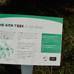
then the track leads past a series of plant information signs[55][56][57][58][59][60][61][62][63][64][65][66][67][68][69][70][71] for 230m to come to another small timber seat

[72]. From this seat this walk leads for another 150m through the forest past a few more plant information signs[73][74][75][76] to then cross a short fibreglass bridge[77]. About 35m past this small bridge the track leads past another seat

(on the left) then 90m later leads between the timber bollards

to find the concrete ‘Silos’ car park[78] beside Millams Rd, Kooragang.
(2.78km) Silos car park → Riverside Park car park
1.1 km
16 mins
0m
0m
Easy track
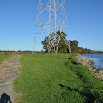
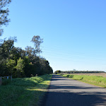
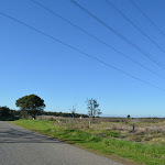
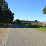
Turn right: From the Silos car park, this walk heads[79] out of the car park and turns left to walk along side Millams Rd[80]. This walk continues along the asphalt road[81] (being careful of traffic) for 300m to head under the power lines[82] then turn left on to the dirt road[83], following ‘The Lane’ sign[84]. This walk then follows the dirt ‘The Lane’ beside the power lines for 700m to come to the asphalt Riverside Park car park[85] at the end of the road.
Maps for the Scotts Point circuit walk
You can download the PDF for this walk to print a map.
These maps below cover the walk and the wider area around the walk, they are worth carrying for safety reasons.
| Beresfield | 1:25 000 Map Series | 92323N BERESFIELD | NSW-92323N |
| Newcastle | 1:100 000 Map Series | 9232 NEWCASTLE | 9232 |
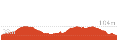
Cross sectional view of the Scotts Point circuit bushwalking track
Analysis and summary of the altitude variation on the Scotts Point circuit
Accessibility summary information for the Scotts Point circuit
Parking: There are 0 designated accessible parking areas on this walk.
Toilets: There are 0 designated accessible toilets on this walk.
Seats: There are 13 places to sit on this walk.
They are on average 220m apart, with a maximum gap of 690m.
Hazards: There are 3 specific noteable accessability related hazards on this walk.
Wheelchair Steep There is a 4m long moderately steep section across the dirt/grass between the trail and the boardwalk. Found about 1850m into the walk.
Trip Hazard A 25m long boggy section of track. The track floods after heavy rain or very high tides. Found about 2150m into the walk.
Trip Hazard A 10m long boggy section of narrow track. The track floods after heavy rain or very high tides. Found about 2190m into the walk.
Accessibility Details
Found 0m into this walk
Found 20m into this walk
Found 350m into this walk
Found 530m into this walk
Found 1220m into this walk
Found 1250m into this walk
Found 1250m into this walk


Found 2240m into this walk


Overview of this walks grade – based on the AS 2156.1 – 2001
Under this standard, a walk is graded based on the most difficult section of the walk.
| Length | 3.9 km | ||
| Time | 1 hr 15 mins | ||
| . | |||
| Grade 3/6 Moderate track |
AS 2156.1 | Gradient | Gentle hills with occasional steps (2/6) |
| Quality of track | Formed track, with some branches and other obstacles (3/6) | ||
| Signs | Clearly signposted (1/6) | ||
| Experience Required | No experience required (1/6) | ||
| Weather | Storms may impact on navigation and safety (3/6) | ||
| Infrastructure | Limited facilities, not all cliffs are fenced (3/6) |
Some more details of this walks Grading
Here is a bit more details explaining grading looking at sections of the walk
Gradient
Around 2.5km of this walk has gentle hills with occasional steps, whilst the remaining 1.3km is flat with no steps.
Quality of track
Around 3.2km of this walk follows a clear and well formed track or trail, whilst the remaining 700m follows a formed track, with some branches and other obstacles.
Signs
This whole walk, 3.9km is clearly signposted.
Experience Required
This whole walk, 3.9km requires no previous bushwalking experience.
weather
Around 3.2km of this walk is not usually affected by severe weather events (that would unexpectedly impact safety and navigation), whilst the remaining 700m is affected by storms that may impact your navigation and safety.
Infrastructure
Around 3.2km of this walk is close to useful facilities (such as fenced cliffs and seats), whilst the remaining 700m has limited facilities (such as not all cliffs fenced).
Similar walks
A list of walks that share part of the track with the Scotts Point circuit walk.
1.3 km Return
30 mins
Easy track
1.9 km One way
45 mins
Easy track
2 km One way
45 mins
Moderate track
2.5 km Return
45 mins
Easy track
Other Nearby walks
A list of walks that start near the Scotts Point circuit walk.
1.2 km Return
30 mins
Very easy
945 m One way
30 mins
Easy track
2.7 km Circuit
1 Hr
Moderate track
2.9 km Circuit
1 hr 15 mins
Moderate track
6.5 km Circuit
2 hrs 30 mins
Moderate track
2.8 km Circuit
1 hr 15 mins
Moderate track
6 km Circuit
2 hrs 30 mins
Moderate track
731 m Circuit
30 mins
Very easy
2.1 km Circuit
1 Hr
Moderate track
1.9 km Circuit
1 Hr
Moderate track
2.5 km Circuit
1 Hr
Moderate track
2 km Circuit
1 Hr
Moderate track
Plan your trip to and from the walk here
The Scotts Point circuit walk starts and ends at the Riverside Park car park (gps: -32.833948, 151.70896)
Your main transport option to Riverside Park car park is by;
![]() Car. There is free parking available.
Car. There is free parking available.
(get details)
Short URL = http://wild.tl/spc
Gallery images
There are other downloads I am still working on.
You will probably need to login to access these — still all free.
* KML (google earth file)
* GPX (GPS file)
Special Maps/ brochures
* A3 topo maps
* PDF with Lands Topo map base
* PDF with arial image (and map overlay)
I wanted to get the main site live first, this extra stuff will come in time.
Happy walking
Matt 🙂
The Welcome walk
And Walk
The Welcome walk

30 mins
945 m One way
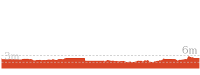
3 m
Easy track
Come and meander at your own pace through this unique saltmarsh ecosystem. The timber boardwalk guides you among the mangroves as you keep an eye out for baby fish and crabs while also enjoy the birdlife. There are seats along the way making it easy to stop and just watch. There are information signs so you can get a deeper understanding of how precious this ecosystem is. Take the short side trip to the old Schoolmaster’s House and step back in time exploring the historic artefacts and displays. The walk finishes with a stroll through Sue’s Garden then along Cobbans Track to the car park. If you don’t organise a lift from the end, allow extra time and retrace your steps or return along the road.


(0km) Mangrove Boardwalk car park → Boardwalk seating area
350 m
5 mins
0m
0m
Very easy
From the Mangrove Boardwalk car park
[1] on Millams Rd Kooragang, (with the large ‘Welcome to Kooragang Wetlands’ sign[2]) this walk follows the ‘Mangrove Boardwalk’ arrow[3] along the timber boardwalk directly away from the road. This walk gently meanders along the boardwalk for about 80m to cross a bridge with (90cm high) hand railings[4], to come to a seat
about 50m later. This walk then continues for the next 160m, passing a few information signs[5][6][7] to find another seat
. The walk continues along the boardwalk through the open wetlands for another 60m to come to a third seat
(on the left).
Mangroves
Mangroves are a type of resistant, salt tolerant and pretty cool tree. They are are a type of halophyte, a plant that grows in salty water. They are perfectly adapted for life in harsh coastal conditions and salt marshes like this one. The plants contain systems to manage the salt levels and root system to anchor in different areas from deep mud to rocky coastlines. The roots also have aerial shoots to help deal with the particular low oxygen levels of mud. The mangroves are great and environmentaly critical to the survival of many animals like crabs and birds.
(0.35km) Boardwalk seating area → Mangrove Boardwalk int.
190 m
3 mins
2m
-2m
Very easy
(0.54km) Mangrove Boardwalk int. → Schoolmasters House
60 m
1 mins
0m
0m
Very easy
Veer left: From the intersection, this walk follows ‘schoolmasters house’ sign[14] gently uphill along the concrete path[15]. After about 20m the path leads past a picnic table
(on the left) and continues for about 30m to come to the front of the ‘School Masters House’[16] (on the right). Access to the old school house is either via smaller steps[17] or around the far side by heading through the car park where there are a few picnic tables
. At the end of this side trip, retrace your steps back to the main walk then Turn left.
Schoolmasters House
The schoolmaster’s house building is now used as the Kooragang Wetlands Information Centre. The building is open to the public (phone 02-4964 9308), with some interesting displays. In 1955 there were over 50 families and this school in the area, when the island was devastated by a massive flood. Following the flood, the area then was taken under state control and was leased for grazing. The school opened in 1873 and closed in 1968.
There are two main entrances. The back entrance has 3 14cm steps to get inside[21]. More info.
There are two main entrances. The back entrance has 3 14cm steps to get inside[21]. More info.
(0.54km) Mangrove Boardwalk int. → Cobbans Track int.
160 m
2 mins
1m
-1m
Very easy
Turn right: From the intersection, this walk follows ‘Cobbans Creek’ arrow sign[22] along the timber boardwalk keeping the open area to the left. After about 40m the boardwalk ends and this walk heads along an asphalt path[23], for about 10m to a seat
and the ‘Sue’s Garden’ sign[24] (both on the left). From here this walk continues along the asphalt path for about 110m, passing two more seats
and a picnic table
(on the left) to cross a short timber bridge and come to the Cobbans Track T-intersection[25], marked by the ‘Cobbans Creek’ sign[26].
(0.69km) Cobbans Track int. → Cobbans car park
250 m
4 mins
0m
0m
Easy track
Turn left: From the intersection, this walk follows the wide gravel trail gently uphill, in the opposite direction of the ‘Cobbans Creek’ arrow [27], initially keeping the timber bridge to the left. This walk continues straight for about 250m to then head around the metal gate beside the timber bollards

to the Cobbans car park[28], marked by the ‘Cobbans Track’ sign[29] just off the side of Millams Rd, Kooragang.
Maps for the The Welcome walk walk
You can download the PDF for this walk to print a map.
These maps below cover the walk and the wider area around the walk, they are worth carrying for safety reasons.
| Beresfield | 1:25 000 Map Series | 92323N BERESFIELD | NSW-92323N |
| Newcastle | 1:100 000 Map Series | 9232 NEWCASTLE | 9232 |
Cross sectional view of the The Welcome walk bushwalking track
Analysis and summary of the altitude variation on the The Welcome walk
Accessibility summary information for the The Welcome walk
Parking: There are 0 designated accessible parking areas on this walk.
Toilets: There are 0 designated accessible toilets on this walk.
Seats: There are 7 places to sit on this walk.
They are on average 110m apart, with a maximum gap of 240m.
Hazards: There are 0 specific noteable accessability related hazards on this walk.
Accessibility Details
Found 530m into this walk
Found 530m into this walk
Found 630m into this walk
Overview of this walks grade – based on the AS 2156.1 – 2001
Under this standard, a walk is graded based on the most difficult section of the walk.
| Length | 945 m | ||
| Time | 30 mins | ||
| . | |||
| Grade 2/6 Easy track |
AS 2156.1 | Gradient | Flat, no steps (1/6) |
| Quality of track | Clear and well formed track or trail (2/6) | ||
| Signs | Clearly signposted (1/6) | ||
| Experience Required | No experience required (1/6) | ||
| Weather | Weather generally has little impact on safety (1/6) | ||
| Infrastructure | Generally useful facilities (such as fenced cliffs and seats) (1/6) |
Some more details of this walks Grading
Here is a bit more details explaining grading looking at sections of the walk
Gradient
This whole walk, 950m is flat with no steps.
Quality of track
Around 690m of this walk follows a smooth and hardened path, whilst the remaining 250m follows a clear and well formed track or trail.
Signs
This whole walk, 950m is clearly signposted.
Experience Required
This whole walk, 950m requires no previous bushwalking experience.
weather
This whole walk, 950m is not usually affected by severe weather events (that would unexpectedly impact safety and navigation).
Infrastructure
This whole walk, 950m is close to useful facilities (such as fenced cliffs and seats).
Similar walks
A list of walks that share part of the track with the The Welcome walk walk.
1.2 km Return
30 mins
Very easy
Other Nearby walks
A list of walks that start near the The Welcome walk walk.
2 km One way
45 mins
Moderate track
1.9 km One way
45 mins
Easy track
1.3 km Return
30 mins
Easy track
2.5 km Return
45 mins
Easy track
3.9 km Circuit
1 hr 15 mins
Moderate track
2.7 km Circuit
1 Hr
Moderate track
6.5 km Circuit
2 hrs 30 mins
Moderate track
2.8 km Circuit
1 hr 15 mins
Moderate track
2.9 km Circuit
1 hr 15 mins
Moderate track
6 km Circuit
2 hrs 30 mins
Moderate track
731 m Circuit
30 mins
Very easy
1.9 km Circuit
1 Hr
Moderate track
Plan your trip to and from the walk here
The The Welcome walk walk starts at the Mangrove Boardwalk car park (gps: -32.844726, 151.69741)
Your main transport option to Mangrove Boardwalk car park is by;
![]() Car. There is free parking available.
Car. There is free parking available.
(get details)
The The Welcome walk ends at the Cobbans car park (gps: -32.84559, 151.70238)
Your main transport option to Cobbans car park is by;
![]() Car. There is free parking available.
Car. There is free parking available.
(get details)
Short URL = http://wild.tl/tww
Gallery images
There are other downloads I am still working on.
You will probably need to login to access these — still all free.
* KML (google earth file)
* GPX (GPS file)
Special Maps/ brochures
* A3 topo maps
* PDF with Lands Topo map base
* PDF with arial image (and map overlay)
I wanted to get the main site live first, this extra stuff will come in time.
Happy walking
Matt 🙂
Scots Point Way to Riverside Park Trail

45 mins
1.9 km One way
0 m
Easy track
On this walk you follow a trail nestled between the Hunter River and the glistening wetlands. You will enjoy an abundance of water birds, water views and plenty of places to sit to take it all in. The walk starts with an optional side trip along a boardwalk before following the old road (now closed to traffic) along side the Green and Golden Bell Frog habitat to the delightful picnic area at Scotts Point. Then the trail leads you along the northern arm of the Hunter River to the car park at Riverside Park. Maybe pack a fishing rod, camera, binoculars or a picnic lunch taking the extra time to enjoy this unique historical and environmentally sensitive area.


(0km) End of Scotts Point Way → Int of Scotts Point and Rainforest tracks
30 m
0m
0m
Easy track

(0.03km) Int of Scotts Point and Rainforest tracks → East end of Rainforest boardwalk
230 m
4 mins
0m
0m
Easy track
Turn right: From the intersection, this walk heads directly away from the river, following ‘The Silos’ arrow[4] down across the dip
and along the dirt track passing 3 seats
to find the fibreglass boardwalk[5]. This walk follows the boardwalk for 200m as it winds through the wetlands giving great views and bird watching opportunities to then come to the end of the raised boardwalk and start of a dirt track. At the end of this side trip, retrace your steps back to the main walk then Turn right.
Rainforest boardwalk
The boardwalk leads through the beautiful Kooragang Wetlands[6] giving great views of the water plants and birds. Specifically, this walk leads over the Water Ribbon Swale, an abandoned channel of the Hunter River. You might be lucky enough to see
Chestnut Teal, Great Egret, Cattle Egret, Glossy Ibis, Australian White Ibis, Straw-necked Ibis, Common Greenshank, Sharp-tailed Sandpiper, Curlew Sandpiper, or if very lucky a Painted Snipe.
Chestnut Teal, Great Egret, Cattle Egret, Glossy Ibis, Australian White Ibis, Straw-necked Ibis, Common Greenshank, Sharp-tailed Sandpiper, Curlew Sandpiper, or if very lucky a Painted Snipe.
(0.03km) Int of Scotts Point and Rainforest tracks → Scotts Point
600 m
9 mins
0m
0m
Easy track
Continue straight: From the intersection, this walk follows the old road directly away from the car park, keeping the sheltered sign[17] and river to the left. After 150m this walk leads past a seat
then after another 180m it leads past another small timber seat[18]
. Just 100m past this seat the walk comes to a ‘Green and Golden Bell Frog’ information sign[19] where the walk continues to gently meander along the edge of the wetlands for 170m to come to the Scotts Point picnic area with a sheltered sitting area
(on the right). There are beautiful views of the confluence of two creeks with a view across a shipping area and a bridge and distant views of the mountains.
Scotts Point
Scotts Point is home to a water tank
, picnic table
and seating shelter
beside an open grassy area at the confluence of the north and south arms of the Hunter River[20]. There are views down the river to Hexham bridge and past some shipping areas[21]. There are a series of signs [22][23][24] to explain more about the local area. This is a lovely spot to rest and enjoy the river and the wetlands.
(0.63km) Scotts Point → Mid way pincic area
700 m
11 mins
0m
0m
Easy track
Continue straight: From Scotts Point sheltered sitting area
, this walk follows the old road, keeping the river to the left. After about 20m this walk leads past a picnic table
then continues along the trail for 220m to pass a ‘Scotts Point Way’ sign[25] where there are more views of the wetlands[26] (to the right). The walk continues along the old road for another 250m to head past a series of large orange triangle boat navigation markers[27] with lovely views over the river[28] then the trail leads back into the she oak forest for about 200m to then cross over a 2.7m wide timber bridge[29] and come to a picnic area with two picnic tables
(on the right).
Mid way pincic area
This relaxed picnic area is found on the banks of the north arm of the Hunter River nestled among She Oaks[30] and the wetlands. There are two picnic tables[31][32]
on concrete slabs beside the trail. The grassy area around the tables can become boggy[33] after rain or very high tides. A pleasant naturally shaded area with some protection from light winds.
(1.33km) Mid way pincic area → Riverside Park car park int
530 m
8 mins
0m
0m
Easy track
Continue straight: From the picnic area
, this walk follows the old asphalt road, directly away from the timber bridge, keeping the river to the left[34]. This walk continues along the trail for 180m to pass a single picnic table
then another 90m to pass a timber seat
(on the right). Continuing along the trail for another 210m this walk leads under the power lines, veers left at the intersection to head past the stone seats
then over the grassy section[35] between the car park and river, to the intersection at the other end of the car park marked by a Riverside Park sign[36].
(1.86km) Riverside Park car park int → City Farm jetty
100 m
1 mins
0m
-1m
Easy track
Continue straight: From the intersection, this walk follows the gravel track to cross the short fibreglass bridge, keeping the river to the left. After about 10m this walk comes to a 3-way intersection with a gravel footpath, marked by an arrow post sign[37].
Continue straight: From the intersection, this walk follows the ‘Jetty’ arrow[38] along the gravel path[39] keeping the river to the left. After about 40m the path leads past a sheltered picnic area
Continue straight: From the intersection, this walk follows the ‘Jetty’ arrow[38] along the gravel path[39] keeping the river to the left. After about 40m the path leads past a sheltered picnic area
and water tap
(on the right) then continues for about 30m to come to a ‘Hunter Wetlands National Park’ information sign[40] (on the right). Here the walk leads onto the floating jetty ramp[41] with 1m metal fence that leads to the City Farm jetty[42] (there is an 8cm step[43] to access the actual jetty platform[44]. At the end of this side trip, retrace your steps back to the main walk then Turn left.
Riverside Park
Riverside Park is found near the end of ‘The Lane’, Kooragang within Hunter Wetlands National Park. There is the City Farm jetty[45] on the banks of the north arm of the Hunter River[46]. You will also find two picnic shelters[47]
, each with a water tank
. There is also an accessible toilet[48]
at the back of the grassy area. There are a few walks that leave from the area and it is also a popular fishing and bird watching area.
Maps for the Scots Point Way to Riverside Park Trail walk
You can download the PDF for this walk to print a map.
These maps below cover the walk and the wider area around the walk, they are worth carrying for safety reasons.
| Beresfield | 1:25 000 Map Series | 92323N BERESFIELD | NSW-92323N |
| Newcastle | 1:100 000 Map Series | 9232 NEWCASTLE | 9232 |
Cross sectional view of the Scots Point Way to Riverside Park Trail bushwalking track
Analysis and summary of the altitude variation on the Scots Point Way to Riverside Park Trail
Accessibility summary information for the Scots Point Way to Riverside Park Trail
Parking: There are 0 designated accessible parking areas on this walk.
Toilets: There are 0 designated accessible toilets on this walk.
Seats: There are 8 places to sit on this walk.
They are on average 260m apart, with a maximum gap of 690m.
Hazards: There are 1 specific noteable accessability related hazards on this walk.
Wheelchair Steep There is a 4m long moderately steep section across the dirt/grass between the trail and the boardwalk. Found about 30m into the walk.
Accessibility Details

Found 620m into this walk
Found 620m into this walk
Found 650m into this walk
Found 1340m into this walk
Found 1520m into this walk
Found 1850m into this walk
Found 1870m into this walk
Overview of this walks grade – based on the AS 2156.1 – 2001
Under this standard, a walk is graded based on the most difficult section of the walk.
| Length | 1.9 km | ||
| Time | 45 mins | ||
| . | |||
| Grade 2/6 Easy track |
AS 2156.1 | Gradient | Gentle hills with occasional steps (2/6) |
| Quality of track | Clear and well formed track or trail (2/6) | ||
| Signs | Clearly signposted (1/6) | ||
| Experience Required | No experience required (1/6) | ||
| Weather | Weather generally has little impact on safety (1/6) | ||
| Infrastructure | Generally useful facilities (such as fenced cliffs and seats) (1/6) |
Some more details of this walks Grading
Here is a bit more details explaining grading looking at sections of the walk
Gradient
Around 1.3km of this walk is flat with no steps, whilst the remaining 550m has gentle hills with occasional steps.
Quality of track
This whole walk, 1.9km follows a clear and well formed track or trail.
Signs
This whole walk, 1.9km is clearly signposted.
Experience Required
This whole walk, 1.9km requires no previous bushwalking experience.
weather
This whole walk, 1.9km is not usually affected by severe weather events (that would unexpectedly impact safety and navigation).
Infrastructure
This whole walk, 1.9km is close to useful facilities (such as fenced cliffs and seats).
Similar walks
A list of walks that share part of the track with the Scots Point Way to Riverside Park Trail walk.
1.3 km Return
30 mins
Easy track
2 km One way
45 mins
Moderate track
2.5 km Return
45 mins
Easy track
3.9 km Circuit
1 hr 15 mins
Moderate track
Other Nearby walks
A list of walks that start near the Scots Point Way to Riverside Park Trail walk.
1.2 km Return
30 mins
Very easy
945 m One way
30 mins
Easy track
2.7 km Circuit
1 Hr
Moderate track
6.5 km Circuit
2 hrs 30 mins
Moderate track
2.8 km Circuit
1 hr 15 mins
Moderate track
2.9 km Circuit
1 hr 15 mins
Moderate track
6 km Circuit
2 hrs 30 mins
Moderate track
731 m Circuit
30 mins
Very easy
1.9 km Circuit
1 Hr
Moderate track
2.1 km Circuit
1 Hr
Moderate track
480 m Circuit
15 mins
Very easy
2.5 km Circuit
1 Hr
Moderate track
Plan your trip to and from the walk here
The Scots Point Way to Riverside Park Trail walk starts at the End of Scotts Point Way (gps: -32.838774, 151.6969)
Your main transport option to End of Scotts Point Way is by;
![]() Car. There is free parking available.
Car. There is free parking available.
(get details)
The Scots Point Way to Riverside Park Trail ends at the Riverside Park car park (gps: -32.833948, 151.70896)
Your main transport option to Riverside Park car park is by;
![]() Car. There is free parking available.
Car. There is free parking available.
(get details)
Short URL = http://wild.tl/spwtrpt
Gallery images
There are other downloads I am still working on.
You will probably need to login to access these — still all free.
* KML (google earth file)
* GPX (GPS file)
Special Maps/ brochures
* A3 topo maps
* PDF with Lands Topo map base
* PDF with arial image (and map overlay)
I wanted to get the main site live first, this extra stuff will come in time.
Happy walking
Matt 🙂
Rainforest walk to Riverside Park
And Walk
Rainforest walk to Riverside Park

45 mins
2 km One way
0 m
Moderate track
This walk leads through the heart of Hunter Wetlands National Park allowing you to explore this area rich in history and nature. The boardwalk takes you through a wetland with great water bird viewing opportunities, the rainforest walk leads you through a diverse forest with information signs about the plants. The walk then finishes with a road walk through open areas to the well-established Riverside picnic area on the banks of the Hunter River.


(0km) End of Scotts Point Way → Int of Scotts Point and Rainforest tracks
30 m
0m
0m
Easy track
(0.03km) Int of Scotts Point and Rainforest tracks → East end of Rainforest boardwalk
230 m
4 mins
0m
0m
Easy track
Turn right: From the intersection, this walk heads directly away from the river, following ‘The Silos’ arrow[4] down across the dip
and along the dirt track passing 3 seats
to find the fibreglass boardwalk[5]. This walk follows the boardwalk for 200m as it winds through the wetlands giving great views and bird watching opportunities to then come to the end of the raised boardwalk and start of a dirt track.
Rainforest boardwalk
The boardwalk leads through the beautiful Kooragang Wetlands[6] giving great views of the water plants and birds. Specifically, this walk leads over the Water Ribbon Swale, an abandoned channel of the Hunter River. You might be lucky enough to see
Chestnut Teal, Great Egret, Cattle Egret, Glossy Ibis, Australian White Ibis, Straw-necked Ibis, Common Greenshank, Sharp-tailed Sandpiper, Curlew Sandpiper, or if very lucky a Painted Snipe.
Chestnut Teal, Great Egret, Cattle Egret, Glossy Ibis, Australian White Ibis, Straw-necked Ibis, Common Greenshank, Sharp-tailed Sandpiper, Curlew Sandpiper, or if very lucky a Painted Snipe.
(0.26km) East end of Rainforest boardwalk → Silos car park
700 m
10 mins
0m
0m
Moderate track
Continue straight: From the east end of Rainforest boardwalk, this walk heads along the grass and dirt track, away from the boardwalk for 160m passing through a few potentially boggy sections
to come to a picnic table
by the ‘Fallen Ash Grove’[17] (on the right). This walk continues along the track for another 35m to pass a small timber seat
then the track leads past a series of plant information signs[18][19][20][21][22][23][24][25][26][27][28][29][30][31][32][33][34] for 230m to come to another small timber seat
[35]. From this seat this walk leads for another 150m through the forest past a few more plant information signs[36][37][38][39] to then cross a short fibreglass bridge[40]. About 35m past this small bridge the track leads past another seat
(on the left) then 90m later leads between the timber bollards
to find the concrete ‘Silos’ car park[41] beside Millams Rd, Kooragang.
(0.96km) Silos car park → Riverside Park car park
1.1 km
16 mins
0m
0m
Easy track
Turn right: From the Silos car park, this walk heads[42] out of the car park and turns left to walk along side Millams Rd[43]. This walk continues along the asphalt road[44] (being careful of traffic) for 300m to head under the power lines[45] then turn left on to the dirt road[46], following ‘The Lane’ sign[47]. This walk then follows the dirt ‘The Lane’ beside the power lines for 700m to come to the asphalt Riverside Park car park[48] at the end of the road.
(2.04km) Riverside Park car park → Riverside Park int
30 m
0m
0m
Easy track
Continue straight: From the Riverside Park car park[49] at the end of The Lane, Kooragang, this walk heads over the grassy and gravel area through timber bollards
[50] for less than 10m to come to an intersection just before the river, marked by a ‘Riverside Park’ sign[51].
Turn right: From the intersection, this walk follows the gravel track to cross the short fibreglass bridge, keeping the river to the left. After about 10m this walk comes to a 3-way intersection with a gravel footpath, marked by an arrow post sign[52]. At the end of this side trip, retrace your steps back to the main walk then Turn around.
Riverside Park
Riverside Park is found near the end of ‘The Lane’, Kooragang within Hunter Wetlands National Park. There is the City Farm jetty[53] on the banks of the north arm of the Hunter River[54]. You will also find two picnic shelters[55]
, each with a water tank
. There is also an accessible toilet[56]
at the back of the grassy area. There are a few walks that leave from the area and it is also a popular fishing and bird watching area.
Maps for the Rainforest walk to Riverside Park walk
You can download the PDF for this walk to print a map.
These maps below cover the walk and the wider area around the walk, they are worth carrying for safety reasons.
| Beresfield | 1:25 000 Map Series | 92323N BERESFIELD | NSW-92323N |
| Newcastle | 1:100 000 Map Series | 9232 NEWCASTLE | 9232 |
Cross sectional view of the Rainforest walk to Riverside Park bushwalking track
Analysis and summary of the altitude variation on the Rainforest walk to Riverside Park
Accessibility summary information for the Rainforest walk to Riverside Park
Parking: There are 0 designated accessible parking areas on this walk.
Toilets: There are 0 designated accessible toilets on this walk.
Seats: There are 5 places to sit on this walk.
They are on average 220m apart, with a maximum gap of 380m.
Hazards: There are 3 specific noteable accessability related hazards on this walk.
Wheelchair Steep There is a 4m long moderately steep section across the dirt/grass between the trail and the boardwalk. Found about 30m into the walk.
Trip Hazard A 25m long boggy section of track. The track floods after heavy rain or very high tides. Found about 330m into the walk.
Trip Hazard A 10m long boggy section of narrow track. The track floods after heavy rain or very high tides. Found about 370m into the walk.
Accessibility Details
Found 420m into this walk
Found 2030m into this walk
Found 2030m into this walk
Overview of this walks grade – based on the AS 2156.1 – 2001
Under this standard, a walk is graded based on the most difficult section of the walk.
| Length | 2 km | ||
| Time | 45 mins | ||
| . | |||
| Grade 3/6 Moderate track |
AS 2156.1 | Gradient | Gentle hills with occasional steps (2/6) |
| Quality of track | Formed track, with some branches and other obstacles (3/6) | ||
| Signs | Clearly signposted (1/6) | ||
| Experience Required | No experience required (1/6) | ||
| Weather | Storms may impact on navigation and safety (3/6) | ||
| Infrastructure | Limited facilities, not all cliffs are fenced (3/6) |
Some more details of this walks Grading
Here is a bit more details explaining grading looking at sections of the walk
Gradient
This whole walk, 2km has gentle hills with occasional steps.
Quality of track
Around 1.3km of this walk follows a clear and well formed track or trail, whilst the remaining 700m follows a formed track, with some branches and other obstacles.
Signs
This whole walk, 2km is clearly signposted.
Experience Required
This whole walk, 2km requires no previous bushwalking experience.
weather
Around 1.3km of this walk is not usually affected by severe weather events (that would unexpectedly impact safety and navigation), whilst the remaining 700m is affected by storms that may impact your navigation and safety.
Infrastructure
Around 1.3km of this walk is close to useful facilities (such as fenced cliffs and seats), whilst the remaining 700m has limited facilities (such as not all cliffs fenced).
Similar walks
A list of walks that share part of the track with the Rainforest walk to Riverside Park walk.
1.3 km Return
30 mins
Easy track
1.9 km One way
45 mins
Easy track
2.5 km Return
45 mins
Easy track
3.9 km Circuit
1 hr 15 mins
Moderate track
Other Nearby walks
A list of walks that start near the Rainforest walk to Riverside Park walk.
1.2 km Return
30 mins
Very easy
945 m One way
30 mins
Easy track
2.7 km Circuit
1 Hr
Moderate track
6.5 km Circuit
2 hrs 30 mins
Moderate track
2.8 km Circuit
1 hr 15 mins
Moderate track
2.9 km Circuit
1 hr 15 mins
Moderate track
6 km Circuit
2 hrs 30 mins
Moderate track
731 m Circuit
30 mins
Very easy
1.9 km Circuit
1 Hr
Moderate track
2.1 km Circuit
1 Hr
Moderate track
480 m Circuit
15 mins
Very easy
2.5 km Circuit
1 Hr
Moderate track
Plan your trip to and from the walk here
The Rainforest walk to Riverside Park walk starts at the End of Scotts Point Way (gps: -32.838774, 151.6969)
Your main transport option to End of Scotts Point Way is by;
![]() Car. There is free parking available.
Car. There is free parking available.
(get details)
The Rainforest walk to Riverside Park ends at the Riverside Park car park (gps: -32.833949, 151.70895)
Your main transport option to Riverside Park car park is by;
![]() Car. There is free parking available.
Car. There is free parking available.
(get details)
Short URL = http://wild.tl/rwtrp
Gallery images
There are other downloads I am still working on.
You will probably need to login to access these — still all free.
* KML (google earth file)
* GPX (GPS file)
Special Maps/ brochures
* A3 topo maps
* PDF with Lands Topo map base
* PDF with arial image (and map overlay)
I wanted to get the main site live first, this extra stuff will come in time.
Happy walking
Matt 🙂
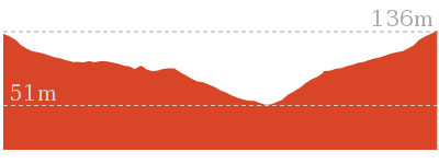
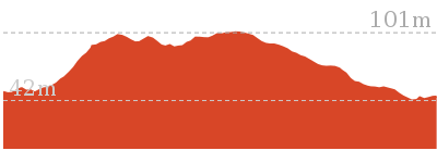
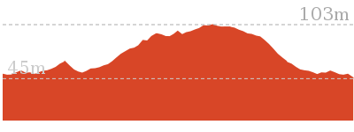
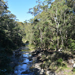
Yuelarbah walking track to Flaggy Creek

40 mins
1.3 km Return
52 m
Easy track
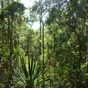
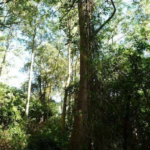
A great way to explore the tree canopy and valley in one easy walk. From the car park, you will be lead along a 100m long elevated timber boardwalk that brings you eye level with the tree canopy. Continue into the valley following the gently undulating wide track to cross Flaggy Creek using a solid suspension bridge. From the bridge, it is just 40m to a pleasant picnic area near the creek. You will find a rough track leading down to the rock platform that forms the Flaggy Creek bed, from the picnic area. The walk is gently sloping downhill most of the way to the picnic area, so it is uphill the way back.


Yuelarbah car park
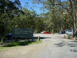
Yuelarbah car park[1] on Burwood Rd, Kahibah is the starting point to a number of walking and MTB tracks within the Glenrock State Conservation Area. There is a sheltered information sign[2] with historical and natural heritage information. There are about 25 parking bays, and a mobility parking bay

.
(0km) Yuelarbah car park → Int of Yuelarbah track AND Glenrock scoutcamp track
580 m
12 mins
13m
-33m
Easy track
From the Yuelarbah car park[3], this walk follows the ‘Yuelarbah walking track’ sign[4] down along the sealed footpath, between the timber bollards

. The footpath has a handrail on each side and initally zig zags[5] downhill before joining the timber boardwalk[6]. The elevated boardwalk[7] has (1m high) handrails[8] and leads through the bush for just shy of 100m, where there is a small step down

on to the gravel track. The walk continues gently downhill along the wide gravel track for 100m to pass a faint rough track (on the left, that leads to a picnic table [9]

). This walk stays on the main wide path as is gently undulates mostly dowhill for another 400m, then coming to a 3-way intersection[10], marked with a ‘Yuelarbah Track’ sign[11] (and track[12] on the right) just before a large foot bridge[13].
(0.58km) Int of Yuelarbah track & Glenrock scoutcamp track → Int of Yuelarbah & Flaggy Creek tracks
40 m
1 mins
3m
-1m
Very easy
(0.62km) Int of Yuelarbah & Flaggy Creek tracks → Flaggy Creek picnic area
40 m
1 mins
1m
-1m
Very easy

Flaggy Creek picnic area
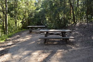
The Flaggy Creek picnic area, is an unsignposted picnic area on the northern side of Flaggy Creek, near the suspension bridge. There are two picnic tables
on a large concrete slab. There is a rough track[24] that leads down to the cascades[25] on the creek. There is also a warning sign saying that the creek water may be contaminated from sewerage overflow and swimming is not advised.[26]. It is, however, a very pleasant spot to enjoy the quiet and peacefull valley.
Maps for the Yuelarbah walking track to Flaggy Creek walk
You can download the PDF for this walk to print a map.
These maps below cover the walk and the wider area around the walk, they are worth carrying for safety reasons.
| Wallsend | 1:25 000 Map Series | 92323S WALLSEND | NSW-92323S |
| Newcastle | 1:100 000 Map Series | 9232 NEWCASTLE | 9232 |
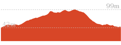
Cross sectional view of the Yuelarbah walking track to Flaggy Creek bushwalking track
Analysis and summary of the altitude variation on the Yuelarbah walking track to Flaggy Creek
Accessibility summary information for the Yuelarbah walking track to Flaggy Creek
Parking: There are 1 designated accessible parking areas on this walk.
Toilets: There are 0 designated accessible toilets on this walk.
Seats: There are 2 places to sit on this walk.
They are 640m apart.
Hazards: There are 1 specific noteable accessability related hazards on this walk.
Trip Hazard Between the gravel path and timber boardwalk is a 5cm step, 1.5m wide. Found about 110m into the walk.
Accessibility Details

Found 0m into this walk


Found 230m into this walk
Found 640m into this walk
Overview of this walks grade – based on the AS 2156.1 – 2001
Under this standard, a walk is graded based on the most difficult section of the walk.
| Length | 1.3 km | ||
| Time | 40 mins | ||
| . | |||
| Grade 2/6 Easy track |
AS 2156.1 | Gradient | Gentle hills with occasional steps (2/6) |
| Quality of track | Smooth and hardened path (1/6) | ||
| Signs | Clearly signposted (1/6) | ||
| Experience Required | No experience required (1/6) | ||
| Weather | Weather generally has little impact on safety (1/6) | ||
| Infrastructure | Generally useful facilities (such as fenced cliffs and seats) (1/6) |
Some more details of this walks Grading
Here is a bit more details explaining grading looking at sections of the walk
Gradient
Around 580m of this walk has gentle hills with occasional steps, whilst the remaining 80m is flat with no steps.
Quality of track
This whole walk, 660m follows a smooth and hardened path.
Signs
This whole walk, 660m is clearly signposted.
Experience Required
This whole walk, 660m requires no previous bushwalking experience.
weather
This whole walk, 660m is not usually affected by severe weather events (that would unexpectedly impact safety and navigation).
Infrastructure
This whole walk, 660m is close to useful facilities (such as fenced cliffs and seats).
Similar walks
A list of walks that share part of the track with the Yuelarbah walking track to Flaggy Creek walk.
7.9 km One way
2 hrs 45 mins
Hard track
12.1 km One way
5 hrs 30 mins
Hard track
25.7 km One way
2 Days
Hard track
Other Nearby walks
A list of walks that start near the Yuelarbah walking track to Flaggy Creek walk.
4.4 km One way
1 hr 30 mins
Moderate track
2.5 km Circuit
1 Hr
Moderate track
2 km Circuit
1 Hr
Moderate track
480 m Circuit
15 mins
Very easy
2.1 km Circuit
1 Hr
Moderate track
1.9 km One way
45 mins
Hard track
948 m Return
30 mins
Hard track
6 km Circuit
2 hrs 30 mins
Moderate track
731 m Circuit
30 mins
Very easy
2.9 km Circuit
1 hr 15 mins
Moderate track
6.5 km Circuit
2 hrs 30 mins
Moderate track
2.8 km Circuit
1 hr 15 mins
Moderate track
Plan your trip to and from the walk here
The Yuelarbah walking track to Flaggy Creek walk starts and ends at the Yuelarbah car park (gps: -32.962127, 151.71977)
Your main transport option to Yuelarbah car park is by;
![]() Car. There is free parking available.
Car. There is free parking available.
(get details)
Short URL = http://wild.tl/ywttfc
Gallery images
There are other downloads I am still working on.
You will probably need to login to access these — still all free.
* KML (google earth file)
* GPX (GPS file)
Special Maps/ brochures
* A3 topo maps
* PDF with Lands Topo map base
* PDF with arial image (and map overlay)
I wanted to get the main site live first, this extra stuff will come in time.
Happy walking
Matt 🙂
Bumble Hill Dray track (Greta Rd to Forest Road to Yarramalong)

2 hrs 45 mins
5.6 km One way
277 m
Hard track
This section of the Great North Walk explores a section of the historic Bumble Hill Dray track. You will walk along the edge of ridge mostly through an open dry eucalypt forests and occasionally through moist ferny gullies as well as alongside the base of a tall rock wall. Bumble Hill Dray track was cut during the mid 1800’s to allow teams of bullocks to haul felled cedar to Mangrove Creek, where a barge would take it to Sydney. The oxen are now long gone, but this is a great way to lead into the small Yarramalong township.
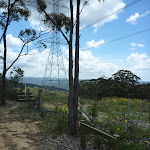
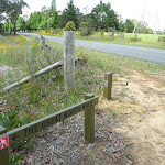
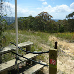


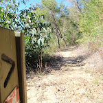


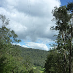


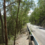
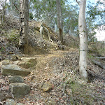
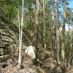
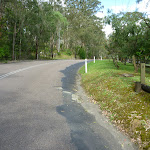
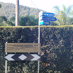


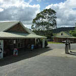
(0km) Int of Greta Road and power line service trail → Bumble Hill Dray track
670 m
15 mins
6m
-89m
Hard track
From the intersection, this walk follows the ‘Great North Walk’ sign[1] over the fence using the stile[2]. Here the walk follows a wide trail around the large tower[3], then follows the narrower track straight down the hill[4]. The track crosses a small gully then leads up to follow a trail[5] around the next tall tower. Here a GNW arrow post[6] leads left, away from the trail and steeply downhill[7] across another valley. The track then leads up to, and follows, another trail up to the other side of a third tower, to find an intersection marked with another GNW track[8] on the other side of the tower.
(0.67km) Bumble Hill Dray track tower → Int of Great North Walk and Bumble Hill Road
4.6 km
2 hrs
270m
-463m
Moderate track
Veer right: From the intersection at the base of the tower[9], this walk follows the GNW arrow post[10] steeply downhill for a short distance, then turns right and follow another GNW arrow post[11] into the bush. About 50m after leaving the clearing, this walk crosses a small timber bridge[12] and continues generally downhill for about 200m before the track bends right (away from the view of the power lines[13]). About 300m further down this track, this walk crosses a small intermittent creek[14]. Then over the next 500m, the track descends into the moist forest[15] to the base of a large cliff face[16] (up to your right), then crosses a section of timber boardwalk[17]. Over the next 100m, the track crosses another handful of sections of boardwalk[18] before the track leads along the side of the hill for a further 500m, out of the moist forest[19], passing some large boulders[20] and leading down to an intersection with a wider trail[21].
Here the walk veers right, following the GNW arrow post along the trail[22] and through the casuarina forest[23] for about 500m, then crosses a gully with a small intermittent creek[24]. The old trail leads generally down through the tall forest for another 1.3km then passes under a set of power lines[25]. Here the walk continues along the side of the valley, following an old trail through the tall eucalypt forest[26] for about 500m to pass through a usually closed gate[27] (staying left at the Y-intersection, just before the gate[28]).
The trail now narrows to a track[29] that leads along side the road (which is up to your right[30]), following a fence for about 180m before turning right and heading steeply up[31] to the safety barrier beside the road. Turning left, this walk now steps over a small stile[32] and follows behind the barrier (with the road on your right) for a short distance before veering left and down the steep rocky track[33] towards the house. The track follows the fence (near the house)[34] below the embankment for about 180m before leading back up to the road[35]. Here the walk follows the road a short distance to come to the end of the safety barrier[36], beside Bumble Hill Road.
(5.31km) Int of Great North Walk and Bumble Hill Road → Yarramalong Track Head
310 m
6 mins
1m
-30m
Easy track
Veer left: From the intersection, this walk follows GNW arrow post[37] gently downhill along the sealed Bumble Hill Rd. The road soon leads past the ’60’ speed limit sign[38], then the road bends left and leads down for another 120m to a T-intersection[39] with Yarramalong Rd, marked with a large ‘Yarramalong Trackhead’ sign[40] (with Yarramalong Store just to your right).
Yarramalong Store
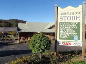
Yarramalong Store is good place to have lunch or pick up the basic food supplies. The store serves hot food including burgers, chips, pies etc as well as cold drinks. The store is open 7am to 7pm, 7 days a week. There is a pay phone outside and a tap to refill water, and the store has its own fuel pump. Phone on (02)4356 1222. The address is 1625 Yarramalong Rd, Yarramalong NSW 2259. I always encourage people to use local stores like this on track, but since it is a small store it is worth phoning ahead to see what they have what you want in stock. It is a small store so choice is limited.
Yarramalong Manor

Yarramalong Manor offers accommodation and a restaurant in the picturesque Yarramalong Valley. The restaurant is open to the public for breakfast & lunch (10am weekdays and 9am weekends) daily, and dinner Friday and Saturday. Yarramalong Manor has 6 guest rooms, each with ensuite, TV, fridge and tea & coffee making facilities. Tariffs for bed and breakfast start at $95 – single, $75/person – twin share. ph:(02) 4356 1066. More info.
Maps for the Bumble Hill Dray track (Greta Rd to Forest Road to Yarramalong) walk
You can download the PDF for this walk to print a map.
These maps below cover the walk and the wider area around the walk, they are worth carrying for safety reasons.
| Kulnura | 1:25 000 Map Series | 91314S KULNURA | NSW-91314S |
| Dooralong | 1:25 000 Map Series | 91311S DOORALONG | NSW-91311S |
| Gosford | 1:100 000 Map Series | 9131 GOSFORD | 9131 |
Cross sectional view of the Bumble Hill Dray track (Greta Rd to Forest Road to Yarramalong) bushwalking track
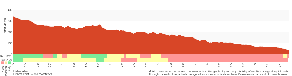
Analysis and summary of the altitude variation on the Bumble Hill Dray track (Greta Rd to Forest Road to Yarramalong)
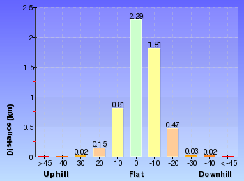
Overview of this walks grade – based on the AS 2156.1 – 2001
Under this standard, a walk is graded based on the most difficult section of the walk.
| Length | 5.6 km | ||
| Time | 2 hrs 45 mins | ||
| . | |||
| Grade 4/6 Hard track |
AS 2156.1 | Gradient | Very steep (4/6) |
| Quality of track | Formed track, with some branches and other obstacles (3/6) | ||
| Signs | Directional signs along the way (3/6) | ||
| Experience Required | Some bushwalking experience recommended (3/6) | ||
| Weather | Storms may impact on navigation and safety (3/6) | ||
| Infrastructure | Limited facilities, not all cliffs are fenced (3/6) |
Some more details of this walks Grading
Here is a bit more details explaining grading looking at sections of the walk
Gradient
4.6km of this walk has short steep hills and another 670m is very steep. The remaining (310m) has gentle hills with occasional steps.
Quality of track
Around 5km of this walk follows a formed track, with some branches and other obstacles, whilst the remaining 310m follows a smooth and hardened path.
Signs
Around 5km of this walk has directional signs at most intersection, whilst the remaining 310m is clearly signposted.
Experience Required
Around 4.6km of this walk requires some bushwalking experience, whilst the remaining 980m requires no previous bushwalking experience.
weather
Around 4.6km of this walk is affected by storms that may impact your navigation and safety, whilst the remaining 980m is not usually affected by severe weather events (that would unexpectedly impact safety and navigation).
Infrastructure
Around 4.6km of this walk has limited facilities (such as not all cliffs fenced), whilst the remaining 980m is close to useful facilities (such as fenced cliffs and seats).
Similar walks
A list of walks that share part of the track with the Bumble Hill Dray track (Greta Rd to Forest Road to Yarramalong) walk.
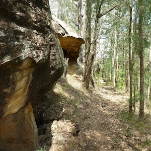
8.1 km One way
3 hrs 30 mins
Hard track
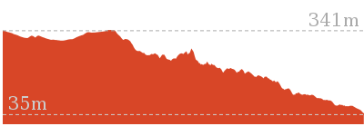
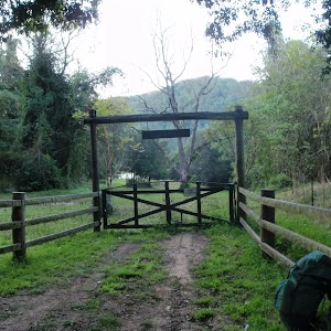
17 km One way
6 hrs 30 mins
Hard track
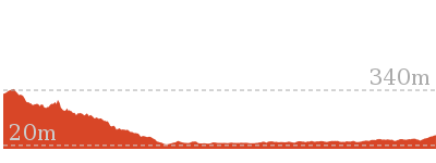

26.7 km One way
2 Days
Hard track
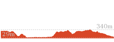
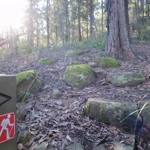
47.4 km One way
3 Days
Hard track
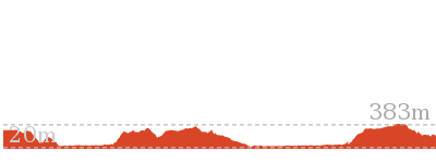
Other Nearby walks
A list of walks that start near the Bumble Hill Dray track (Greta Rd to Forest Road to Yarramalong) walk.
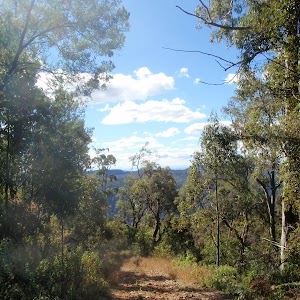
33.7 km One way
2 Days
Hard track
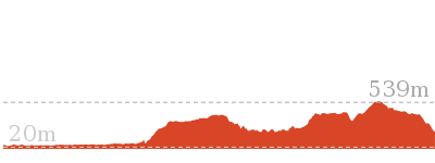
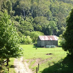
11 km One way
3 hrs 30 mins
Easy track
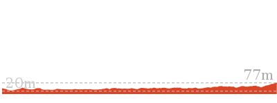
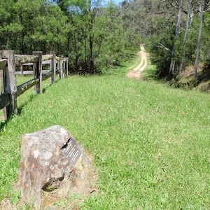
24.3 km Circuit
2 Days
Hard track
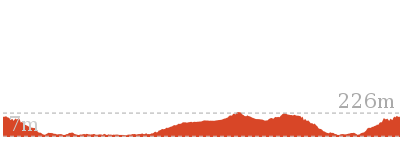
7.2 km Return
3 hrs 15 mins
Moderate track
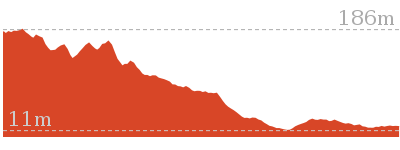
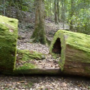
9.7 km One way
4 hrs 30 mins
Hard track

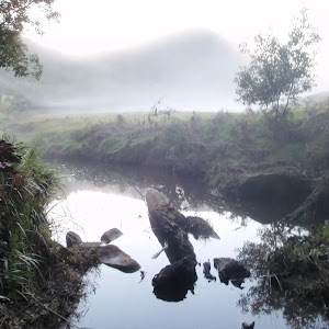
9.7 km One way
4 hrs
Hard track
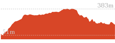
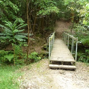
11.2 km One way
4 hrs 30 mins
Hard track
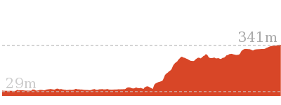
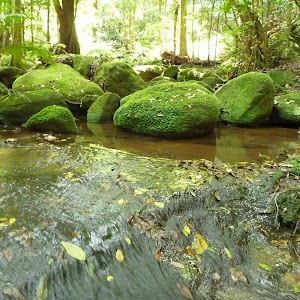
15 km One way
5 hrs 30 mins
Hard track
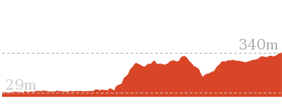

6 km One way
2 hrs 30 mins
Hard track
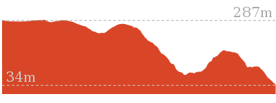
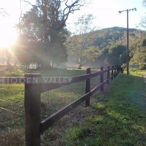
21.1 km One way
8 hrs
Hard track
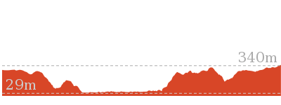
13 km One way
6 hrs
Hard track
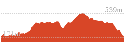
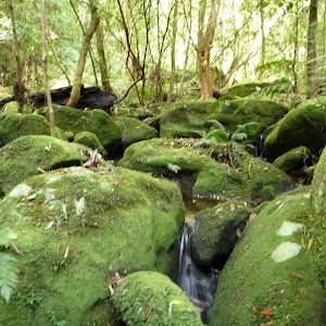
13 km One way
6 hrs
Hard track

Plan your trip to and from the walk here
The Bumble Hill Dray track (Greta Rd to Forest Road to Yarramalong) walk starts at the Int of Greta Road and power line service trail (gps: -33.240185, 151.24794)
Your transport options to Int of Greta Road and power line service trail are by;
![]() Car. There is free parking available.
Car. There is free parking available.
(get details)
![]() Bus. A bus School service runs along Yarramalong Rd from Wyong. Since this is a school bus service it only heads into Yarramalong twice a day. Phone Busway on (02) 4392 6666 to organise a pick up (they are happy to take passengers. (get details)
Bus. A bus School service runs along Yarramalong Rd from Wyong. Since this is a school bus service it only heads into Yarramalong twice a day. Phone Busway on (02) 4392 6666 to organise a pick up (they are happy to take passengers. (get details)
The Bumble Hill Dray track (Greta Rd to Forest Road to Yarramalong) ends at the Yarramalong Track Head (gps: -33.22407, 151.27853)
Your main transport option to Yarramalong Track Head is by;
![]() Car. There is free parking available.
Car. There is free parking available.
(get details)
Short URL = http://wild.tl/bhdtrtfrty
Gallery images
There are other downloads I am still working on.
You will probably need to login to access these — still all free.
* KML (google earth file)
* GPX (GPS file)
Special Maps/ brochures
* A3 topo maps
* PDF with Lands Topo map base
* PDF with arial image (and map overlay)
I wanted to get the main site live first, this extra stuff will come in time.
Happy walking
Matt 🙂
Somersby Store to Greta Road
And Walk
Somersby Store to Greta Road

8 hrs
21.1 km One way
924 m
Hard track
This section of the Great North Walk starts from the Somersby General Store and winds north, through the Jilliby State Conservation Area, and finishes at the corner of Greta Road and Cherry Lane. At just under 20km, this full day walk explores the Palm Grove, Hidden Valley and Ourimba Creek tracks, winding around the Tuggerah Lake field archery range and following the outside edge of a farming property.

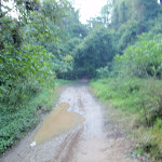

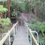


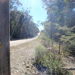
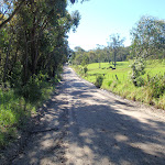
Somersby Store

Somersby Store offers a good place to have lunch or pick up the basic food supplies. The store serves hot food including burgers, chips, pies etc and cold drinks. Opening hours are 6am – 6pm Monday to Friday and 6.30am to 4pm on Saturdays (closed Sundays). There is a pay phone and a bus stop however services are limited to two buses a day. Contact details are (02)4372 1269, at 841 Wisemans Ferry Road Somersby, NSW 2250. The store owners are happy for you to phone ahead. If you are a large group you can order ahead to save the stress. I always encourage people to use local stores like this on track, but since it is a small store it is worth phoning ahead to see what they have what you want in stock.
(0km) Somersby Store → End of Kilkenny Road
2.6 km
48 mins
54m
-69m
Moderate track
From the Somersby Store[1], this walk heads north, gently downhill along the side of ‘Wisemans Ferry Rd’, past the public toilet[2]. After about 120m, this walk crosses an on-ramp[3] then heads over the bridge[4] crossing Peats Ridge Road, then past another on-ramp[5]. The walk continues along Wisemans Ferry Rd for about 700m to then turn sharp right at the three-way intersection[6], onto ‘Dog Trap Rd’[7]. Just over 100m along Dog Trap Rd, this walk turns left into ‘Kilkenny Rd’[8]. The walk follows Kilkenny Rd past the rural properties[9] for about 1.2km, where the walk continues along the now dirt road[10]. About 50m after becoming dirt, the road leads across a rock ford[11] that can be extremely slippery when wet. The walk continues up along the dirt road[12] for another 300m to come to the end of the road and a ‘Great North Walk’ sign[13], beside ‘Illawong’ (farm).
(2.63km) End of Kilkenny Road → creek crossing
1.4 km
32 mins
11m
-207m
Hard track
Continue straight: From the northern end of Kilkenny Road next to ‘Illawong’ (farm)[14], this walk follows the ‘The Great North Walk’ sign[15] along the management trail, between the two farms[16]. After about 300m, the trail leads to a clearing[17], where this walk turns right to follow the GNW arrow post along track beside the fence line[18] (keeping the paddock on your right) for about 70m. The walk then turns left and follows the ‘The Great North Walk’ sign[19] down the hill. The track leads steeply at first[20] and become progressively less steep as the walk heads down the ridge line, until almost flattening out[21] about 400m after leaving the farm. The track then bends left and winds steeply down the side of the ridge, down a series of rock steps[22] for about 600m, leading into a dense moist rain forest. The track passes some wonderful examples of bird’s nest ferns (Asplenium australasicum)[23] before the last little walk down to the rocky intermittent creek[24]. This walk then crosses the creek in the mossy, cool and moist valley[25].
(4.01km) creek crossing → Palm Grove Campsite intersection
1 km
28 mins
114m
-25m
Hard track
Continue straight: From beside the creek[26], this walk follows the GNW arrow post[27] uphill, using the series of rock steps[28]. The track leads uphill, passing some notably large trees[29] over about 120m to then turn right onto a leafy trail[30]. Here the walk crosses an ephemeral creek[31] then continues along the leafy trail in the shaded rainforest[32]. After about 250m, the walk turns left, following the ‘Great North Walk’ sign[33] gently up along a narrow track for about 60m to pass a large strangler fig tree[34]. Just past the fig, this track begins to climb steeply up a series of rock steps[35] and switch-backs[36] for about 100m to pass along side a rock wall[37] (on your right). Just past the rock wall, this walk ducks under a fallen tree[38] then continues steeply (into the more open forest) up more rock steps[39] and switchback for another 250m, where the track flattens out and comes to the signposted ‘Walker Register’ tube[40]. After leaving your comments, and having a bit of a read of other people’s adventures, this walk turns right and follows the GNW arrow post[41] along the top of the ridge, through a clearing[42]. Here the walk start to lead down along the top of the ridge[43] for about 150m to come to a three-way intersection[44], marked with a couple of GNW arrow posts (just before a campsite[45], ahead).
(5.05km) Palm Grove Campsite intersection → Ourimbah Valley Trackhead
990 m
24 mins
15m
-143m
Hard track
Turn left: From the intersection, this walk follows the GNW arrow post north-west, gently down off the side of the ridge[46] (initially keeping the campsite track down to your right). The track leads down along the side of the ridge[47] for about 150m before leading much more steeply down a series of rock steps[48] for about 200m. The track mostly flatten out just before passing a tall fig growing over a large boulder[49] (on your right). Here the track winds more gently downhill for about 150m to pass a couple cabbage palms (Livistona australis)[50], then continues to wind fairly steeply down for another 400m where the track mostly flattens out again[51]. Near the end of this 400m, the track leads through a short weedy section before heading down a short embankment[52] to a T-intersection with the dirt Ourimbah Creek Rd[53], marked with a large ‘Ourimbah Valley Trackhead’ sign[54].
(6.04km) Ourimbah Valley Trackhead → Int of Platypus Creek La and Ourimbah Creek Rd
1.8 km
32 mins
30m
-25m
Easy track
Turn sharp left: From the ‘Ourimbah Valley Trackhead’[55] (on Ourimbah Creek Rd), this walk follows the ‘Newcastle’ sign downhill along the dirt road. The road soon leads down and across a flat timber vehicle bridge[56] then the road mostly flattens out, winding among the rural properties for almost 300m to pass a ‘Palm Grove Nature Reserve’ sign[57] and a few ‘Hidden Valley’ signs[58]. The walk continues along the road for about 700m then comes to the intersection in front of the Hidden Valley property (on your left, not far before another road bridge).
This walk continues straight, gently downhill along the wide dirt road to almost immediately pass ‘Wombats End’ (private road)[59] then cross the flat timber road bridge[60]. After about 400m, the road leads under some high tension power lines[61] then after another 150m of winding past the rural properties[62], this walk passes a timber ‘Hidden Valley’ private property shelter[63] and water tank (on your right). A further 100m along the road past this shelter, the walk veers left (ignoring ‘Platypus Creek La’) to come to a locked gate with a ‘Road Closed’ sign[64].
This walk continues straight, gently downhill along the wide dirt road to almost immediately pass ‘Wombats End’ (private road)[59] then cross the flat timber road bridge[60]. After about 400m, the road leads under some high tension power lines[61] then after another 150m of winding past the rural properties[62], this walk passes a timber ‘Hidden Valley’ private property shelter[63] and water tank (on your right). A further 100m along the road past this shelter, the walk veers left (ignoring ‘Platypus Creek La’) to come to a locked gate with a ‘Road Closed’ sign[64].
(7.88km) Int of Platypus Creek La and Ourimbah Creek Rd → Forty Acres
2 km
36 mins
39m
-43m
Moderate track
Continue straight: From the gate (near the intersection of Ourimbah Creek Road and Platypus Creek La), this walk heads up around the locked gate and follows the Ourimbah Creek Rd trail along the side of the valley for about 800m, where it crosses a culverted creek[65]. From here, the walk continues along the clear trail as it gently undulates alongside Ourimbah Creek (which is down the steep bank on your right) for about 1.2km until coming to a three-way intersection, marked with a ‘Great North Walk’ sign[66], just before the gates of ‘Forty Acres’ property[67].
(9.86km) Forty Acres → Stringy Bark Point
1.8 km
33 mins
43m
-33m
Moderate track
Turn left: From the intersection, this walk follows the ‘Great North Walk’ sign[68] north-east along the clear trail. This trail gently undulates along the side of Ourimbah Creek[69] (which is down the steep bank on your right) for about 1.6km, then passes a campsite with a metal fireplace[70] (on your right). Here the walk continues along the trail for about 100m to head past a track[71] (on your right, that leads down to the sandy creek) and continues along the main trail for another 150m to come to large clearing and campsite, Stringy Bark Point[72] at the end of the trail (marked with a timber and metal footbridge[73] on the right).
Stringy Bark Point

This campsite is in a small clearing at Stringy Bark Point, just on the southern side of the bridge. This campsite provides room for a small campfire and a few tents. Water is usually available from the creek running by the campsite, please treat before drinking.
(11.68km) Stringy Bark Point → Int of Great North Walk and Tooheys Road south
1.8 km
53 mins
237m
-42m
Hard track
Veer right: From Stringy Bark Point campsite[74], this walk heads across the timber and metal footbridge[75] (with a small mossy canyon on your right[76]). Once on the other side of the bridge, the old trail gently undulates west through the bush[77] for about 300m where this walk turns right following a GNW arrow post down a few rock steps[78]. The distinct track leads fairly steeply down to find, then cross, the perennial Ourimbah Creek[79]. This creek may become impassable after heavy or prolonged rain.
On the other side, the track leads up the bank then gently up through the dense, leafy forest for about 50m, following a series of GNW arrow posts. The track then starts to lead steeply uphill for about 100m and leaves the dense forest, climbing up onto the more open ridge. Here the track mostly flattens out, leading over a rocky area[80] to then come to a large ant hill[81]. The track now leads uphill for about 250m to pass some cabbage palms (Livistona australis)[82]. The track starts to climb steeply again for about 150m, up some stone steps[83] (and past a rock with a view[84]) to where the track mostly flattens out again for about 60m, coming to a three-way intersection that is marked with a GNW arrow post[85]. Here the walk veers left and follows this old trail steeply uphill[86] for about 130m, before turning left at another GNW arrow post[87]. This track soon bends sharp right and leads up some stone steps[88] then comes to an intersection[89] (with the same old trail). Here the walk leads gently uphill for about 30m, over the a rise (ignoring the faint track on your right), after which the track leads gently down through the tall forest[90] for about 300m and comes to an T-intersection with the dirt Tooheys Rd[91], marked with a ‘The Great North Walk’ signpost[92].
On the other side, the track leads up the bank then gently up through the dense, leafy forest for about 50m, following a series of GNW arrow posts. The track then starts to lead steeply uphill for about 100m and leaves the dense forest, climbing up onto the more open ridge. Here the track mostly flattens out, leading over a rocky area[80] to then come to a large ant hill[81]. The track now leads uphill for about 250m to pass some cabbage palms (Livistona australis)[82]. The track starts to climb steeply again for about 150m, up some stone steps[83] (and past a rock with a view[84]) to where the track mostly flattens out again for about 60m, coming to a three-way intersection that is marked with a GNW arrow post[85]. Here the walk veers left and follows this old trail steeply uphill[86] for about 130m, before turning left at another GNW arrow post[87]. This track soon bends sharp right and leads up some stone steps[88] then comes to an intersection[89] (with the same old trail). Here the walk leads gently uphill for about 30m, over the a rise (ignoring the faint track on your right), after which the track leads gently down through the tall forest[90] for about 300m and comes to an T-intersection with the dirt Tooheys Rd[91], marked with a ‘The Great North Walk’ signpost[92].
(13.51km) Int of Great North Walk and Tooheys Road south → Int of Great North Walk and Tooheys Road north
2.3 km
52 mins
139m
-67m
Hard track
Turn left: From the intersection, this walk follows the ‘Camping Area’ sign[93] north, down along the wide dirt road. The road soon crosses a saddle and starts to lead uphill, then meanders (quite steeply in places) along the ridge and through a variety of forests for about 2.2km, before passing a ‘Caution Archery In Progress At Any Time – Keep to the Main Track’ sign[94]. Just over 100m past this sign, the road leads up to an intersection marked with a GNW arrow post[95], and the signposted GNW track (on your left)
(15.81km) Int of Old GNW track and Tooheys Rd → Archers Campsite
160 m
3 mins
1m
-3m
Moderate track
Continue straight: From the intersection, this walk follows the GNW arrow post[96] uphill along the wide dirt road. After about 30m, the road bends right[97] (ignoring the trail on the left) and leads gently up for about 150m to pass below the campsite, then come to the signposted intersection with the ‘Camping Area’[98] (on your left) At the end of this side trip, retrace your steps back to the main walk then Veer right.
Archers Campsite

This informally named campsite is found in Jilliby State Conservation Area, and is used regularly by members of the Tuggerah Lake Field Archers club. This is a basic campsite with a water tank[99][100] and shed used for hanging shower water bags[101][102]. The large open camping area has a few existing fire scars[103] and a few flat grassy areas. (There are other facilities 150m further north along the dirt trail at the club house.)
(15.81km) Int of GNW and Tooheys Road north → Powerline tower west of Dead Horse Creek
1.9 km
48 mins
106m
-174m
Hard track
Turn sharp left: From the intersection, this walk follows the ‘Yarramalong’ sign[104] along the narrow track (away from the dirt road) following a small ridge[105]. After about 50m this walk turns right, following a GNW arrow post[106] off the side of the ridge. The track now leads down along the side of the hill through the wooded forest[107] mostly fairly gently downhill for 500m to cross a small (usually dry) gully[108]. The track continues a little steeper down the hill among the gymea Lilie and eucalypt forest[109] for just over 150m to pass a notable termite mound[110]. About 150m past this mound the track starts to zig zag and head more steeply downhill for yet another 150m to come to the cool and mossy Dead Horse Creek[111].
Here the walk crosses Dead Horse Creek[112] (this creek may become impassable after prolonged or heavy rain), then follows the GNW arrow post [113] up the side of the hill. The track initially zig zags steeply
then more gently up as it generally contours north along the side of the hill for about 250m to cross a small gully and often dry side creek[114]. The track continues along the side of the main valley through the cool and dense wooded forest for just over 250m (where there are a few sections of faint track). Here the track starts to veer left and climb the side, of the valley quiet steeply at times for around 400m, where the forest becomes dryer and more open until the track leads to the side of a large high tension power-line tower[115].
(17.72km) Powerline tower west of Dead Horse Creek → Int of GNW and Cherry Lane
1.5 km
30 mins
53m
-26m
Moderate track
Continue straight: From the high tension powerline tower[116], this walk heads uphill along the widening track[117], initially keeping the tower on your left. After 200m this walk turns left at an intersection[118] marked with a “private Property” sign[119], following a GNW arrow post[120]. This walk continues along the track through the scribbly gum forest[121] for about 70m to then continue straight ahead at four-way intersection[122] (with a wider trail)[123]. From here this walk continues through the wooded forest for another 400m to where the view open up as the track passes through a 150m section of heath[124] (ignoring a few fainter side tracks). Now the track leads back through a lightly wooded forest for another 250m to come to a clear intersection with a wider management trail, at the corner of a fence[125].
From here, this walk continue straight, following the track along the side of the fence (keeping the fence to your right[126]) for 400m where the track leads under a set of high tension power lines[127], beside some farm land[128]. Continuing along the fence line the track soon leads across a section of timber duckboard[129] then after another 100m crosses a small flat timber bridge (over a small sandy creek)[130]. Just another 80m later the track leads
up to a locked gate[131] and to a T-intersection with Cherry Lane, marked with a few GNW arrows[132].
(19.26km) Int of Great North Walk and Cherry Lane → Int of Greta Road and Cherry Lane
1.4 km
27 mins
54m
-15m
Easy track
Turn right: From the intersection[133], this walk follows the GNW arrow post gently uphill[134] along Cherry Lane, a gravel road. After 800m this walk continues straight ahead passing an intersection at the top of the hill[135]. From here the road leads downhill for about 400m to pass a notable dam close to the road[136] (on your right). Now the walk leads gently up along the gravel road for another 250m to a T-intersection with the sealed ‘Greta Rd’[137]
marked with a ‘The Great North Walk’ signpost[138] (on your right).
marked with a ‘The Great North Walk’ signpost[138] (on your right).
(20.65km) Int of Greta Road and Cherry Lane → Int of Greta Road and power line service trail
430 m
9 mins
29m
0m
Easy track
Turn right: From the intersection[139], this walk follows the ‘The Great North Walk’ sign[140] gently uphill along the grassy verge (under the power lines) keeping Greta Road just to your left[141]. After 120m this walk crosses a driveway[142] and continues along side the road for almost 250m to near the top of the hill, just before the high tension power lines. Here the walk turns left to cross the road to find a ‘Great North Walk’ signposted[143] intersection beside a locked gate and style[144].
Maps for the Somersby Store to Greta Road walk
You can download the PDF for this walk to print a map.
These maps below cover the walk and the wider area around the walk, they are worth carrying for safety reasons.
| Kulnura | 1:25 000 Map Series | 91314S KULNURA | NSW-91314S |
| Mangrove | 1:25 000 Map Series | 91313N MANGROVE | NSW-91313N |
| Wyong | 1:25 000 Map Series | 91312N WYONG | NSW-91312N |
| Gosford | 1:100 000 Map Series | 9131 GOSFORD | 9131 |
Cross sectional view of the Somersby Store to Greta Road bushwalking track
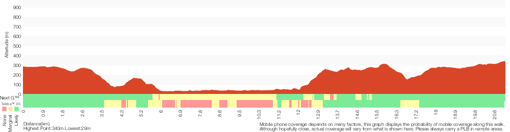
Analysis and summary of the altitude variation on the Somersby Store to Greta Road
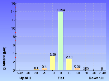
Overview of this walks grade – based on the AS 2156.1 – 2001
Under this standard, a walk is graded based on the most difficult section of the walk.
| Length | 21.1 km | ||
| Time | 8 hrs | ||
| . | |||
| Grade 4/6 Hard track |
AS 2156.1 | Gradient | Very steep (4/6) |
| Quality of track | Rough track, where fallen trees and other obstacles are likely (4/6) | ||
| Signs | Minimal directional signs (4/6) | ||
| Experience Required | Moderate level of bushwalking experience recommended (4/6) | ||
| Weather | Forecast, unforecast storms and severe weather may impact on navigation and safety (4/6) | ||
| Infrastructure | Limited facilities (such as cliffs not fenced, significant creeks not bridged) (4/6) |
Some more details of this walks Grading
Here is a bit more details explaining grading looking at sections of the walk
Gradient
10km of this walk has gentle hills with occasional steps and another 9km is very steep. The remaining (1.5km) has short steep hills.
Quality of track
8km of this walk follows a clear and well formed track or trail and another 4.4km follows a smooth and hardened path. Whilst another 4.4km follows a formed track, with some branches and other obstacles and the remaining 4.3km follows a rough track, where fallen trees and other obstacles are likely.
Signs
10km of this walk has directional signs at most intersection and another 6km is clearly signposted. The remaining (4.3km) has minimal directional signs.
Experience Required
10km of this walk requires no previous bushwalking experience and another 6km requires some bushwalking experience. The remaining (4.8km) requires a leader a with moderate level of bushwalking experience.
weather
17km of this walk is not usually affected by severe weather events (that would unexpectedly impact safety and navigation) and another 2.6km is affected by storms that may impact your navigation and safety. The remaining (1.9km) is affected by forecast, unforecast storms and severe weather events that may impact on navigation and safety.
Infrastructure
12km of this walk is close to useful facilities (such as fenced cliffs and seats) and another 6km has limited facilities (such as not all cliffs fenced). The remaining (3.3km) has limited facilities (such as cliffs not fenced, significant creeks not bridged).
Similar walks
A list of walks that share part of the track with the Somersby Store to Greta Road walk.
6 km One way
2 hrs 30 mins
Hard track
11.2 km One way
4 hrs 30 mins
Hard track
15 km One way
5 hrs 30 mins
Hard track
17 km One way
6 hrs 30 mins
Hard track
26.7 km One way
2 Days
Hard track
47.4 km One way
3 Days
Hard track
Other Nearby walks
A list of walks that start near the Somersby Store to Greta Road walk.
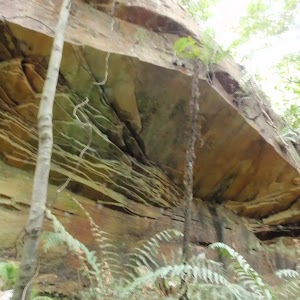
1.7 km Return
45 mins
Moderate track
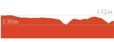
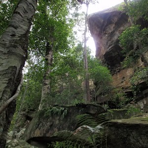
3 km Circuit
1 hr 30 mins
Moderate track
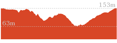
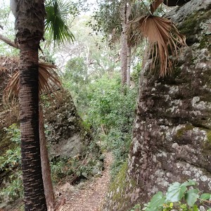
1.7 km Circuit
1 Hr
Moderate track
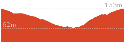
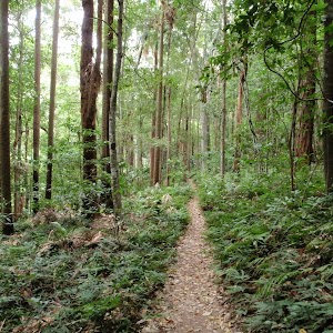
2.2 km One way
1 Hr
Moderate track
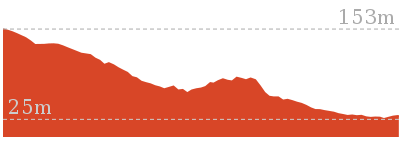
1.8 km Circuit
1 Hr
Moderate track
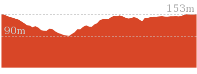
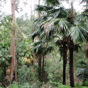
8.1 km Circuit
3 hrs 30 mins
Moderate track
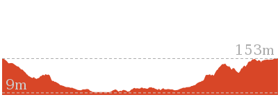
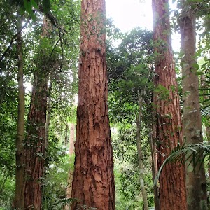
2.3 km Circuit
1 Hr
Moderate track
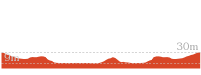
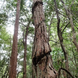
3.3 km Circuit
1 hr 15 mins
Moderate track
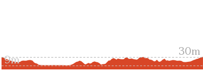
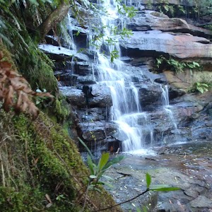
426 m Return
20 mins
Moderate track
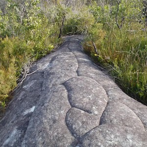
8.3 km Return
3 hrs 15 mins
Moderate track
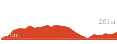
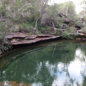
10.8 km Circuit
4 hrs 15 mins
Hard track
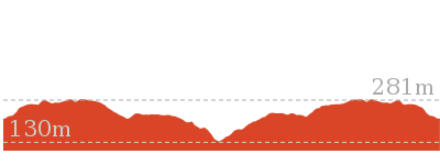
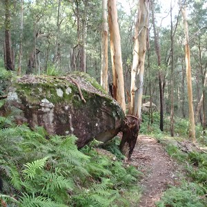
10.1 km Return
4 hrs 15 mins
Hard track
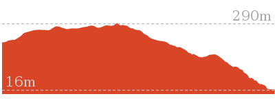
Plan your trip to and from the walk here
The Somersby Store to Greta Road walk starts at the Somersby Store (gps: -33.358078, 151.29029)
Your transport options to Somersby Store are by;
![]() Bus. A bus service runs along Wisemans Ferry Rd passing Somersby store. The service runs between Gosford and Spencer only a few times a day. Please check timetable for more info or Phone Busway on (02) 4368 2277. The bus only picks passengers up from Somersby to head to Gosford on the morning runs. (get details)
Bus. A bus service runs along Wisemans Ferry Rd passing Somersby store. The service runs between Gosford and Spencer only a few times a day. Please check timetable for more info or Phone Busway on (02) 4368 2277. The bus only picks passengers up from Somersby to head to Gosford on the morning runs. (get details)
![]() Car. There is free parking available.
Car. There is free parking available.
(get details)
The Somersby Store to Greta Road ends at the Int of Greta Road and power line service trail (gps: -33.240274, 151.24802)
Your main transport option to Int of Greta Road and power line service trail is by;
![]() Car. There is free parking available.
Car. There is free parking available.
(get details)
Short URL = http://wild.tl/sstgr
Gallery images
There are other downloads I am still working on.
You will probably need to login to access these — still all free.
* KML (google earth file)
* GPX (GPS file)
Special Maps/ brochures
* A3 topo maps
* PDF with Lands Topo map base
* PDF with arial image (and map overlay)
I wanted to get the main site live first, this extra stuff will come in time.
Happy walking
Matt 🙂
Comments