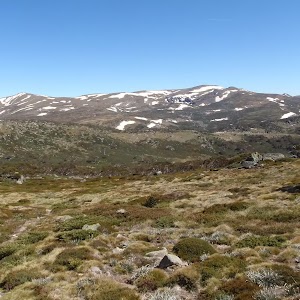
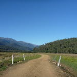
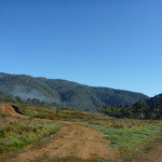
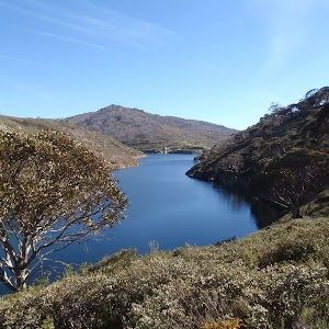
This walk starts with a ride up the Kosciuszko Express Chairlift. There is an opportunity to eat at Australia’s highest restaurant, before heading over the Rams Head Range. After enjoying the spectacular views from the Rams Head Range, the walk drops to Dead Horse Gap, then follows a bush track along the Thredbo river. After passing the golf course, the walk returns to the base of the chairlift. Alternatively, you may organise a lift from Dead Horse Gap.
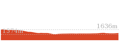
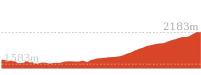
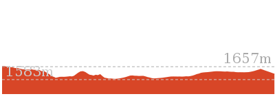
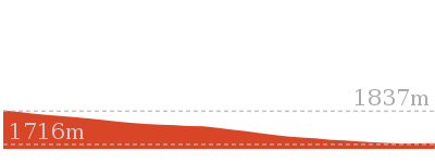
Dead Horse Gap Loop track
And Walk
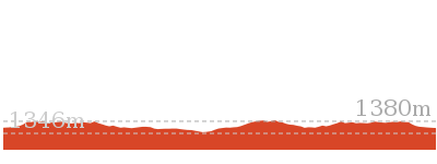
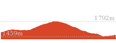
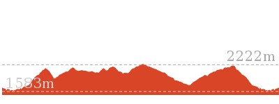
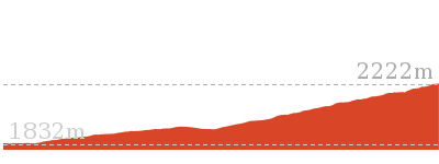
Dead Horse Gap Loop track


4 hrs 30 mins
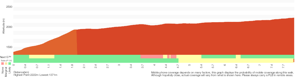
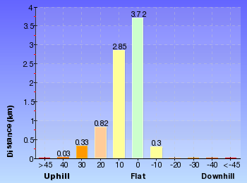
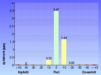
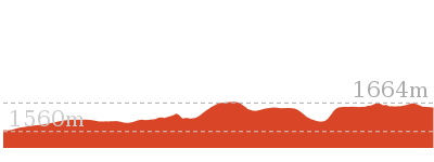
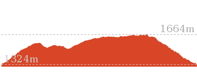
9.8 km Circuit

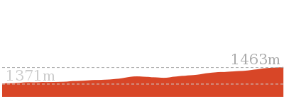
144 m
Hard track


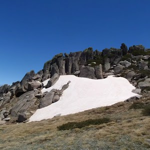
Covered in snow part of the year
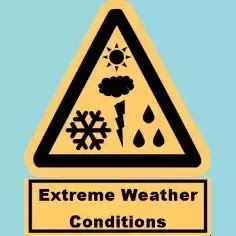
This walk leads through an extreme alpine environment and all walkers must be well prepared. During summer, be prepared for both very hot and cold weather, high winds, rain, snow, extreme UV levels and some sections of snow or ice on the ground. Before starting this walk, check advice with Snowy Region Visitor Information Centre (02) 6450 5600, the weather forecast and the snow conditions then change your plans as needed. These notes, grades and walking times have been written for use in the summer months only. Between May and the end of October, this walk is likely to be covered in snow/ice, visitors should be carrying and be prepared to use snowshoes or cross country skis. When there is a chance of significant snow on the ground, visitors will need particularly strong navigation and snowcraft skills – tracks and signage may not be visible. For most visitors, it is best to consider this walk closed during the colder months.
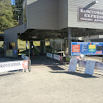
Kosciuszko Express Chairlift
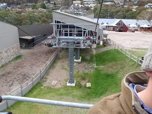
This is one of the few lifts operating in the summer months at Thredbo, and is made quite popular by thousands of people walking to the summit of Mt Kosciuszko each year. Lift tickets can be purchased from the store at the bottom of the chairlift. Lift tickets are $31 return ($25 one way) per person. This lift is generally closed during November and May for maintenance each year, but the the Snowgum chair can be used at this time instead, this will add extra walking time to you walk. More info.
(0km) Bottom of Kosciuszko Express chairlift → Top of Kosciuszko Express chairlift

1.9 km
20 mins
558m
-1m
Very easy
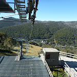
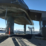
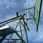
This walk heads into the ‘Valley Terminal’ building, where you can buy a ticket for the lift. Continue through the building and up the steps, where this walk turns right to find the bottom terminal of the ‘Kosciuszko Express’. Walk up to the platform as directed by the chairlift operator and sit down in the seat, letting it scoop you up. Once seated, pull down the safety bar and enjoy the ride to the top of the ridge. 🙂
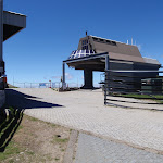
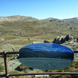
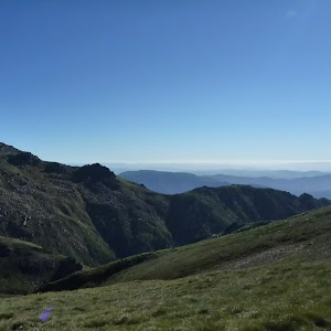
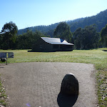
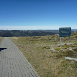
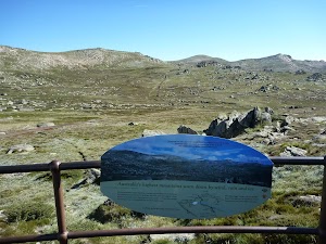
At the top step of the chair lift and turn left to find the restaurant (now on your right) and track information signs ahead.
At the top step of the chair lift and turn left to find the restaurant (now on your right) and track information signs ahead.
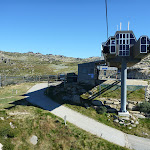
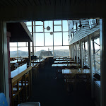
Eagles Nest Restaurant

This is Australia’s highest restaurant, providing great food and outstanding views. It is easily accessible, nestled on the mountain directly opposite the top of the Kosciuszko Express chairlift, and is open year-round. For more information, call (02) 64576019.
(1.86km) Top of Kosciuszko Express chairlift → Int of Dead Horse Gap track and Kosciuszko footpath
350 m
6 mins
23m
0m
Moderate track
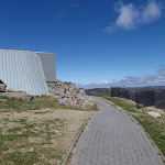
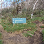
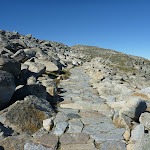
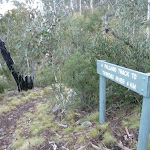
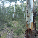
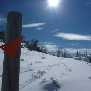
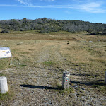
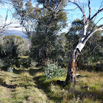
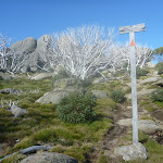
Turn right: From the top of the chairlift[3], this walk follows the footpath around Eagles Nest restaurant[4][5] (keeping the building to your right). The walk passes the large map[6] and information signs[7], heading up the gentle hill along the paved path[8]. Near the top of the rise, the path leads to a signposted intersection with the ‘Dead Horse Gap’ track[9] (on your left), where there is also an arrow pointing back to ‘Eagles Nest Restaurant’[10].
(2.21km) Int of Dead Horse Gap track and Kosciuszko footpath → Top of Basin Tbar
110 m
2 mins
10m
-1m
Hard track
Veer left: From the intersection, the track follows the rocky bush track a short distance to the top of the Basin Tbar.
(2.32km) Top of Basin Tbar → Upper rest area
1.7 km
36 mins
54m
-74m
Hard track
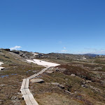
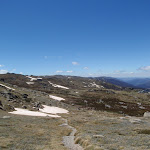
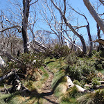
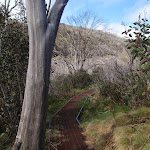
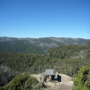
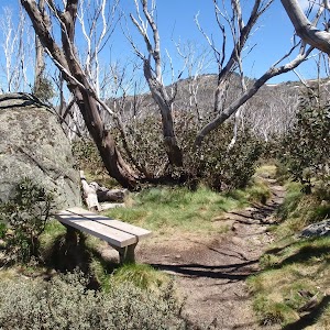
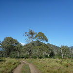
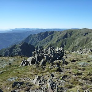
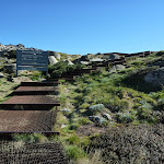
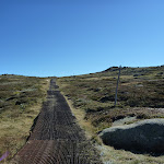
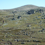
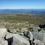
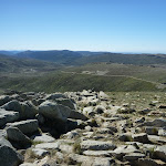
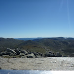
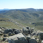
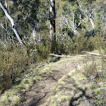
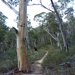
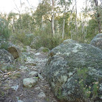
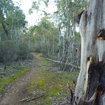
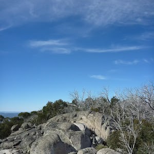
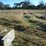
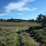
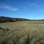
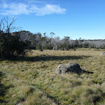
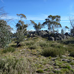
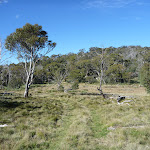
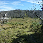
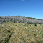
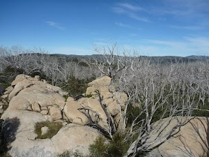
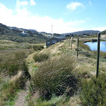
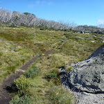
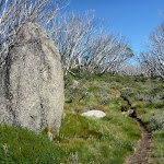
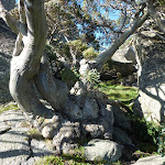
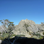
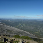
Continue straight: From the top of the Tbar, the walk follows the bush track heading west along the ridgeline. The track climbs the hill, passing numerous rock outcrops, and reaches an information sign titled “above the tree line”.
Continue straight: From the signpost, the walk follows the bush track along the ridgeline, down the hill. The track passes a long line of ski run markers, continuing down towards the tree line until it comes to the intersection at the wooden bench.
Continue straight: From the signpost, the walk follows the bush track along the ridgeline, down the hill. The track passes a long line of ski run markers, continuing down towards the tree line until it comes to the intersection at the wooden bench.
(3.99km) Upper rest area → Int of Thredbo River and Dead Horse Gap tracks
3 km
1 hr 27 mins
11m
-405m
Moderate track
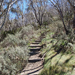
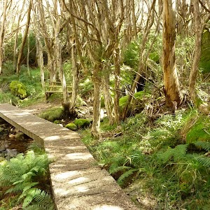
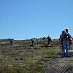
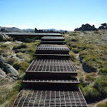
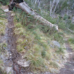
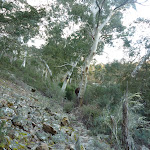
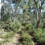
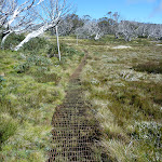
Continue straight: From the intersection, the walk follows the bush track down the hill. The track winds down the long hill, crossing some metal walkways and wooden boardwalks, then passing through the snowgum forest until it comes to the second, small rest area at the wooden bench seat.
Continue straight: From the bench, the walk follows the bush track down the rocky hill. The track passes through the open snow gum forest, down into the valley. The track goes down a long set of wooden steps and comes to an intersection signposted ‘Dead Horse Gap track’.
Continue straight: From the bench, the walk follows the bush track down the rocky hill. The track passes through the open snow gum forest, down into the valley. The track goes down a long set of wooden steps and comes to an intersection signposted ‘Dead Horse Gap track’.
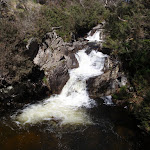
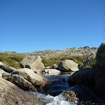
(7.02km) Int of Thredbo River and Dead Horse Gap tracks → Cascades Trail track head
160 m
3 mins
3m
-6m
Moderate track
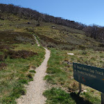
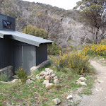
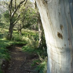
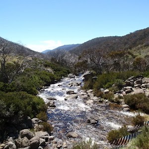
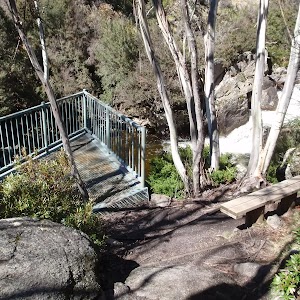
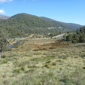
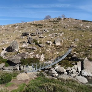
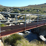
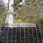
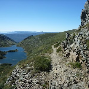
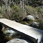
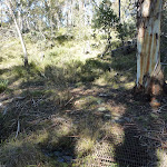
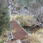
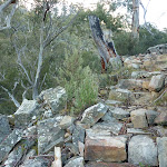
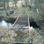
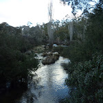
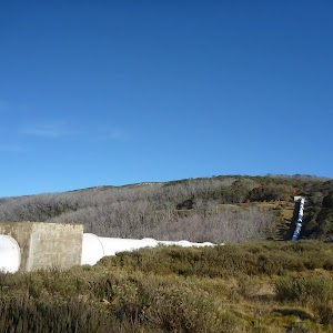
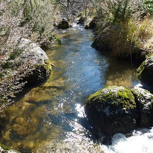
Turn right: From the intersection, this walk follow the clear track away from the other two sign posted tracks to soon cross Bogong Creek[11] on a metal bridge[12]. The track then leads left and heads up a series of steps to follow behind the road barrier, soon coming to a ‘Thredbo Walking Tracks’ sign[13] beside the road. Here the walk crosses the road to find the Cascades Trail track head car park (on the Alpine Way 5.4km west of Friday Drive).
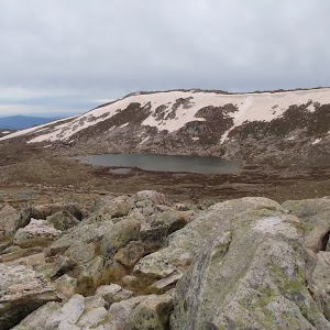
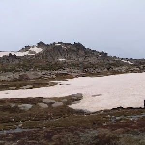
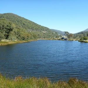
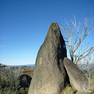
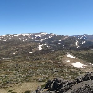
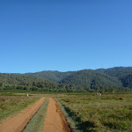
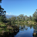
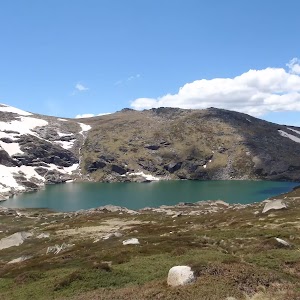
Dead Horse Gap
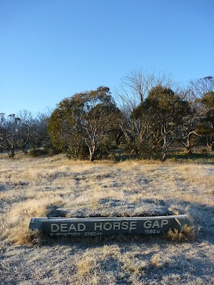
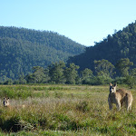
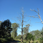
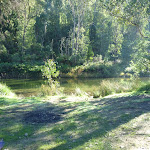
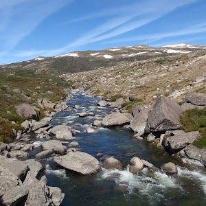
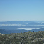
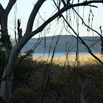
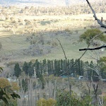
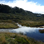
Dead Horse Gap is a relativley low mountain pass in the Great Dividing Range at 1582m AMSL. It was once a meeting place for Aboriginal groups in the summer, where they would perform ceremonies and trade with each other. In nature the pass acts as a funnel for the migration of insects and birds[14]. In the early 20th century, the pass became increasingly popular with stockmen, who brought sheep and cattle to the mountains each summer.[15]
(7.02km) Int Thredbo River and Dead Horse Gap tracks → Thredbo River track western bridge
1.1 km
23 mins
8m
-68m
Moderate track
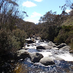
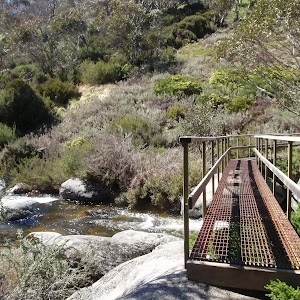
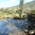
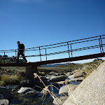
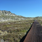
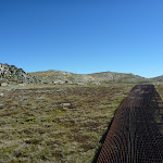
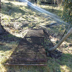
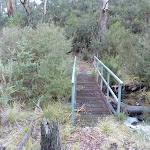
Veer left: From the intersection, this walk follows the ‘Thredbo village 4km’ sign[16] gently downhill whilst keeping the valley (and road) to your right. The track gently undulates along the side of the valley and after about 600m the track leads over a series of metal erosion control grates[17]. The walk continues crossing a series of these grates for about another 600m before leading down a long series of steps[18] to find a large metal bridge[19].
(8.09km) Thredbo River western bridge → Thredbo River eastern bridge
340 m
7 mins
6m
-15m
Moderate track
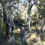
Continue straight: From the small clearing[20], this walk crosses Thredbo River using the long metal bridge[21]. This walk then turns left and heads through the grassy flat (initially over a metal grate[22]) enjoying the scattering of snow gums[23]. Before too long the track comes closer to the river again the leads down a log lined set of stairs[24] to cross the Thredbo River again on another metal bridge[25].
(8.43km) Int of Thredbo River track at eastern bridge → Cascades lookout
470 m
9 mins
8m
-21m
Moderate track
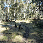
Continue straight: From the bridge, this walk crosses to the north side of the river and follows the bush track downstream, winding down the hill and through the snowgum forest. The walk continues along a metal walkway followed by a wooden boardwalk, then heads down a long hill to the intersection at the Thredbo River Cascades lookout platform.
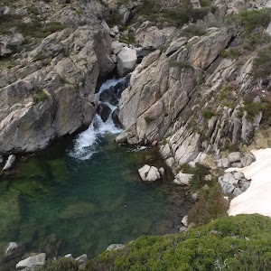
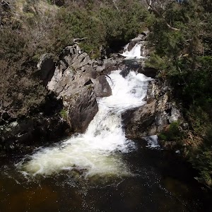
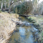
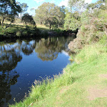
Cascades Lookout
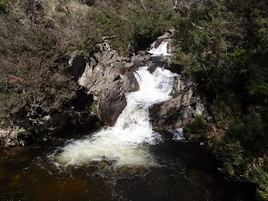
This metal platform leans over the Thredbo River, lookout upstream to the flowing cascades. There is also a wooden seat provided here, making it a great rest stop, conveniently situated about half way between Dead Horse Gap and Thredbo Village, on the Thredbo River track.
(8.9km) Cascades lookout → Int of Thredbo River and golf course tracks
1.3 km
27 mins
12m
-69m
Moderate track
Continue straight: From the lookout, this walk winds down the hill following the Thredbo River track as it continues along the creek, winding through the snow gum forest and crossing several metal walkways, continuing down some wooden steps until coming to the signposted intersection of the golf course loop track.
(10.19km) Int of Thredbo River and Golf Course Walk tracks → Int of Riverside Walk and Thredbo River bridge
810 m
15 mins
1m
-30m
Moderate track
Continue straight: From the intersection, this walk heads away from the face of the ‘Thredbo River Track’ sign[26] to follow the track east down the hill. The track leads down a series of steps the gently meanders along the side of the Thredbo River. Soon after passing the the green timber pump house[27], this walk comes to an intersection beside a small timber bridge[28] (that heads over a small creek onto the golf course).
Continue straight: From the intersection[29], this walk follows the track away from the golf course down the gentle hill and over a small metal bridge[30], keeping the main river to your right[31]. The track leads through the bush between the golf course and the river, crossing several sections of metal walkways[32] until winding back up to the golf course to soon come to an intersection at a large wooden bridge[33] (that crosses Thredbo River).
Continue straight: From the intersection[29], this walk follows the track away from the golf course down the gentle hill and over a small metal bridge[30], keeping the main river to your right[31]. The track leads through the bush between the golf course and the river, crossing several sections of metal walkways[32] until winding back up to the golf course to soon come to an intersection at a large wooden bridge[33] (that crosses Thredbo River).
(11km) Int of Riverside Walk and Thredbo River bridge → Int behind the community centre
80 m
2 mins
0m
-3m
Moderate track
Continue straight: From the timber bridge[34], this walk follows the clear track[35] keeping the river to your right. The track soon leads around the edge of the golf course and over a short metal bridge[36]. About 30m after this track leads to an intersection[37] (where the track on the right leads down to the creek), behind the community centre.
(11.08km) Int behind the community centre → Thredbo Memorial Community Centre
120 m
2 mins
1m
-4m
Moderate track
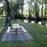
Thredbo Golf Course
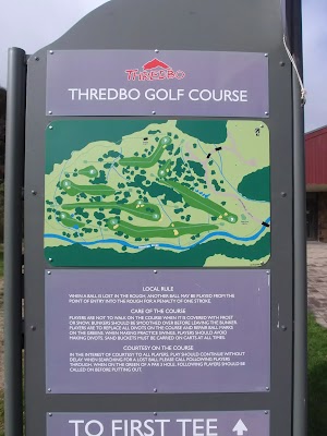
This nine hole AGU (Australian Golf Union) rated course is the highest in Australia. Nestled in beside Thredbo village, and bordering the Thredbo River, this course offers a great form of relaxation, and gives golfers a wonderful way to enjoy the Snowies, without having to travel too far from the village. More info.
(11.2km) Thredbo Memorial Community Centre → Bottom of Kosciuszko Express chairlift
480 m
9 mins
10m
-11m
Very easy
Turn right: From the Community Centre[42], this walk follows the road across the bridge[43], over Thredbo River to come to a signposted intersection with ‘Friday Drive’[44].
Turn left: From the intersection, this walk heads downhill following the ‘Friday Drive’ sign[45] past the pond (on your right). The road leads through a car park and past the children’s play ground[46]. In time the walk follow the footpath beside the road[47] that leads under a footbridge[48], where this walk then turns left across the road bridge[49]. Here the walk tends left up the road to find a large map[50] and the entrance to the tickets station[51] at the bottom of Kosciuszko Express chairlift.
Turn left: From the intersection, this walk heads downhill following the ‘Friday Drive’ sign[45] past the pond (on your right). The road leads through a car park and past the children’s play ground[46]. In time the walk follow the footpath beside the road[47] that leads under a footbridge[48], where this walk then turns left across the road bridge[49]. Here the walk tends left up the road to find a large map[50] and the entrance to the tickets station[51] at the bottom of Kosciuszko Express chairlift.
Maps for the Dead Horse Gap Loop track walk
You can download the PDF for this walk to print a map.
These maps below cover the walk and the wider area around the walk, they are worth carrying for safety reasons.
| Perisher Valley | 1:25 000 Map Series | 85252S PERISHER VALLEY | NSW-85252S |
| Chimneys Ridge | 1:25 000 Map Series | 85241N CHIMNEYS RIDGE | NSW-85241N |
| Kosciuszko | 1:100 000 Map Series | 8525 KOSCIUSZKO | 8525 |
| Jacobs River | 1:100 000 Map Series | 8524 JACOBS RIVER | 8524 |
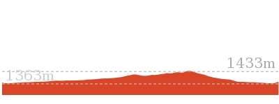
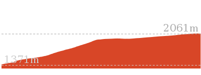
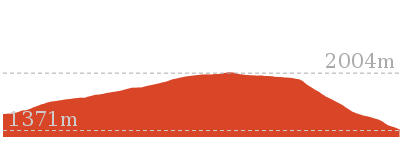
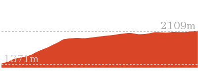
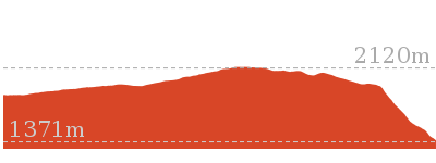
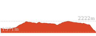
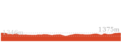
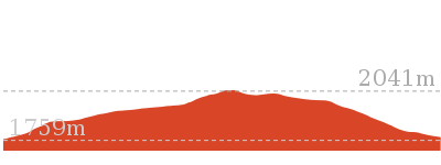
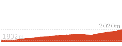
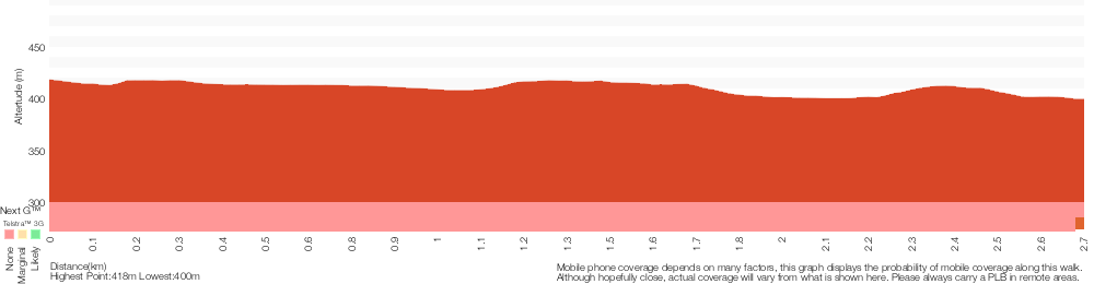
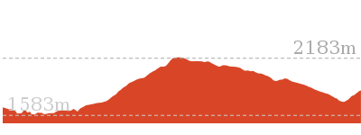
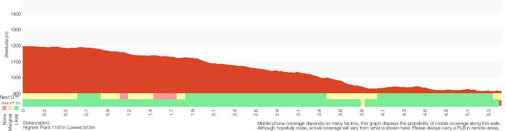
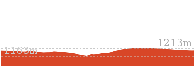
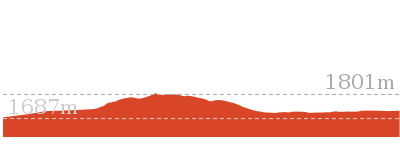
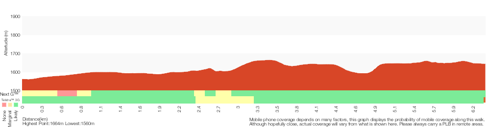
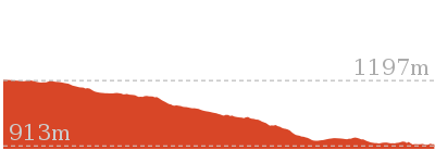
Cross sectional view of the Dead Horse Gap Loop track bushwalking track

Analysis and summary of the altitude variation on the Dead Horse Gap Loop track

Overview of this walks grade – based on the AS 2156.1 – 2001
Under this standard, a walk is graded based on the most difficult section of the walk.
| Length | 9.8 km | ||
| Time | 4 hrs 30 mins | ||
| . | |||
| Grade 4/6 Hard track |
AS 2156.1 | Gradient | Short steep hills (3/6) |
| Quality of track | Formed track, with some branches and other obstacles (3/6) | ||
| Signs | Directional signs along the way (3/6) | ||
| Experience Required | Some bushwalking experience recommended (3/6) | ||
| Weather | Forecast, unforecast storms and severe weather may impact on navigation and safety (4/6) | ||
| Infrastructure | Limited facilities, not all cliffs are fenced (3/6) |
Some more details of this walks Grading
Here is a bit more details explaining grading looking at sections of the walk
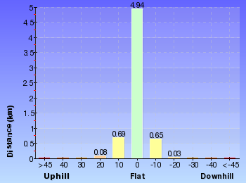
Gradient
5km of this walk has short steep hills and another 4km has gentle hills with occasional steps. The remaining (2.4km) is flat with no steps.
Quality of track
8km of this walk follows a formed track, with some branches and other obstacles and another 2.7km follows a smooth and hardened path. The remaining (890m) follows a clear and well formed track or trail.
Signs
Around 7km of this walk is clearly signposted, whilst the remaining 4.9km has directional signs at most intersection.
Experience Required
Around 8km of this walk requires some bushwalking experience, whilst the remaining 4.2km requires no previous bushwalking experience.
weather
8km of this walk is not usually affected by severe weather events (that would unexpectedly impact safety and navigation) and another 2.8km is affected by storms that may impact your navigation and safety. The remaining (1.3km) is affected by forecast, unforecast storms and severe weather events that may impact on navigation and safety.
Infrastructure
Around 8km of this walk is close to useful facilities (such as fenced cliffs and seats), whilst the remaining 3.5km has limited facilities (such as not all cliffs fenced).
Similar walks
A list of walks that share part of the track with the Dead Horse Gap Loop track walk.
3.3 km Circuit
1 hr 15 mins
Moderate track
3.7 km Circuit
2 hrs 30 mins
Hard track
3.8 km Return
2 hrs 30 mins
Hard track
4.1 km Return
1 hr 45 mins
Moderate track
4.7 km Return
2 hrs
Moderate track
4.8 km One way
1 hr 45 mins
Moderate track
5.3 km One way
3 hrs
Hard track
5.8 km Circuit
3 hrs
Hard track
7.5 km Return
3 hrs 45 mins
Hard track
10.1 km Circuit
5 hrs
Hard track
12.2 km One way
5 hrs
Hard track
12.4 km Return
6 hrs
Hard track
25.8 km One way
2 Days
Experienced only
Other Nearby walks
A list of walks that start near the Dead Horse Gap Loop track walk.
3.1 km Circuit
1 hr 30 mins
Hard track
3.3 km Circuit
1 hr 15 mins
Moderate track

2.2 km Return
1 Hr
Hard track
2.9 km Circuit
1 hr 15 mins
Moderate track
9.7 km Return
4 hrs
Hard track
19.6 km Return
7 hrs 30 mins
Hard track

778 m Return
30 mins
Moderate track
2.4 km Return
1 hr 30 mins
Hard track
4.2 km Circuit
2 hrs 15 mins
Hard track
3.8 km Return
1 hr 45 mins
Hard track
15.2 km Return
5 hrs 30 mins
Hard track
12 km Return
4 hrs 30 mins
Hard track
Plan your trip to and from the walk here
The Dead Horse Gap Loop track walk starts and ends at the Bottom of Kosciuszko Express chairlift (gps: -36.503981, 148.30397)
Your main transport option to Bottom of Kosciuszko Express chairlift is by;
![]() Car. A park entry fee is required for driving into the park.
Car. A park entry fee is required for driving into the park.
(get details)


Short URL = http://wild.tl/ww
Gallery images
There are other downloads I am still working on.
You will probably need to login to access these — still all free.
* KML (google earth file)
* GPX (GPS file)
Special Maps/ brochures
* A3 topo maps
* PDF with Lands Topo map base
* PDF with arial image (and map overlay)
I wanted to get the main site live first, this extra stuff will come in time.
Happy walking
Matt 🙂
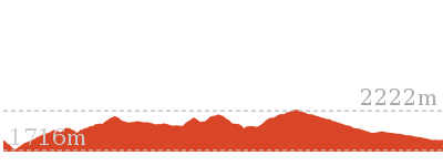
Old Geehi Hut tour
And Walk
Old Geehi Hut tour

2 hrs
5.5 km Return
82 m
Hard track
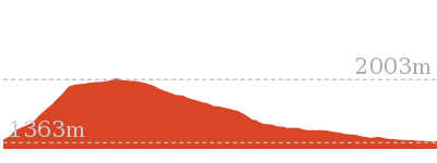
This walk takes you on a tour of some of the historic huts north of Geehi Flats. Starting from the northern end of Geehi Flats Camping area near Geehi Hut, you will cross Swampy Plains River and walk across the plain to an intersection just before Keebles Hut. Here the walk heads up on the higher section of Behrs Flat and then down and across Swampy Plains River again. You will then follow another trail to the old Geehi Hut, once used as a youth hostel.


Snow & Ice on walk
This walk leads through an alpine environment and all walkers must be well prepared. During summer, be prepared for both hot and cold weather, high winds, rain, extreme UV levels and some sections of snow or ice on the ground. Before starting this walk, check advice with Snowy Region Visitor Information Centre (02) 6450 5600, the weather forecast and the snow conditions then change your plans as needed. These notes, grades and walking times have been written for use in the summer months only. Between May and the end of October, there is a much higher change of snow, ice and extremely cold conditions.
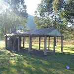
Geehi Picnic Camping Ground
This is a very large campsite with plenty of space for roaming about and with some interesting things to explore. The campsite sits on the bank of the Swampy Plain River, which offers some opportunities for fishing. There are plenty of toilets scattered around (with access for people in wheelchairs). There are several stone shelters, historic huts, and walking tracks in the area. The individual campsites are not marked out, but there are plenty of spots to choose. There is no charge for camping (although vehicle entry fees apply).
(0km) Geehi Hut car park → Geehi Hut
70 m
1 mins
0m
-3m
Easy track
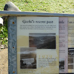
From the car park, this walk heads north[1] away from the face of ‘The Western Fall’ sign[2] along the paved path. The path soon turns away from the road and crosses a small ditch[3] to find a book-like ‘Geehi’s recent past’ information sign[4]. Here the walk heads across the grass to Geehi Hut a short distance away[5].
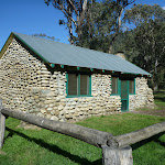
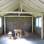
Geehi Hut
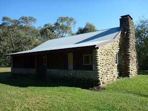
Geehi Hut, also known as Airstrip or Nankervis Hut, was originally built in 1952 by Jim Nankervis and his brother, to assist with grazing[6]. The 11m x 9m river stone building has three rooms, including a fireplace[7] (not for use). Near the hut is a wheelchair-accessible toilet[8] and plenty of space for camping. The hut was restored in 2004 by the NPWS. The remains of the older Tyrrell’s Hut[9] can be seen nearby. More info.
(0km) Geehi Hut car park → Int of Swampy Plain and Bicentennial Trails
190 m
3 mins
5m
-5m
Hard track
Turn right: From the car park, this walk heads west along the dirt road[10] away from the toilet whilst initially keeping the hut a short distance to your right. The trail soon leads past a locked gate[11] (on your right) and the down to a few campsites[12] just before Swampy Plain River crossing and a ‘To Behrs Flat – 4 Wheel Drive’ sign[13].
Continue straight: From the intersection, this walk crosses the rocky ford Swamp Plain River crossing[14][15]. This river is impassable after rain or snow melt, take care not to cross when the river is too high or too fast. Once on the other bank, this walk heads through the gate[16] (locked to vehicles in wet conditions) and comes to a clear, three-way intersection with another 4WD trail[17] (on your left).
Continue straight: From the intersection, this walk crosses the rocky ford Swamp Plain River crossing[14][15]. This river is impassable after rain or snow melt, take care not to cross when the river is too high or too fast. Once on the other bank, this walk heads through the gate[16] (locked to vehicles in wet conditions) and comes to a clear, three-way intersection with another 4WD trail[17] (on your left).
(0.19km) Geehi Rest Area Entrance → Int of Swampy Plain and Bicentennial Trails
1.2 km
23 mins
37m
-40m
Hard track
Turn left: From the entrance to Geehi Rest Area[18], this walk follows the ‘Jindabyne’ sign[19] along the Alpine Way[20]. The road soon leads across a bridge[21], over Swampy Plains River and comes to an intersection with a 4WD trail[22] (on your right), just on the other side of the bridge.
Turn right: From the western side of Geehi Bridge[23], this walk follows the 4WD trail off the main road, down the short hill[24] and along the side of Swampy Plain River (keeping the river to your right). The walk soon passes a short side trail[25] (on your right, that leads down to the river[26]), continuing instead parallel to the river along the clear trail through the trees[27]. The trail soon passes a ‘To Behrs Flat – 4 wheel drive – Dry weather only’ sign[28] and continues through the forest for about 400m to a large turning circle[29] (on your right), just before a gate[30] (locked to vehicles in wet conditions). From this turning area, this walk continues along the trail steeply uphill[31], through the gate. As the trail reaches the high point, there are good views down to Swampy Plain River and across Geehi Flats[32]. The trail then leads down the hill to a three-way intersection[33] with the Bicentennial National Trail at Behrs Flat (to your left[34]) and a gate[35] and creek crossing (to your right). Now Veer left to rejoin the main walk .
Turn right: From the western side of Geehi Bridge[23], this walk follows the 4WD trail off the main road, down the short hill[24] and along the side of Swampy Plain River (keeping the river to your right). The walk soon passes a short side trail[25] (on your right, that leads down to the river[26]), continuing instead parallel to the river along the clear trail through the trees[27]. The trail soon passes a ‘To Behrs Flat – 4 wheel drive – Dry weather only’ sign[28] and continues through the forest for about 400m to a large turning circle[29] (on your right), just before a gate[30] (locked to vehicles in wet conditions). From this turning area, this walk continues along the trail steeply uphill[31], through the gate. As the trail reaches the high point, there are good views down to Swampy Plain River and across Geehi Flats[32]. The trail then leads down the hill to a three-way intersection[33] with the Bicentennial National Trail at Behrs Flat (to your left[34]) and a gate[35] and creek crossing (to your right). Now Veer left to rejoin the main walk .
(0.19km) Int of Swampy Plain and Bicentennial Trails → Keebles Loop intersection
60 m
1 mins
1m
-1m
Moderate track
Veer right: From the intersection, this walk follows the flat trail north-west into Behrs Flat clearing[36] (directly away from Swampy Plain River). After a short distance, the trail comes to a ‘Y’ intersection[37] with a grassy trail (on your right), just before a couple of trees standing by themselves.
(0.25km) Keebles Loop intersection → Int south of Keebles Hut
790 m
12 mins
1m
-10m
Hard track
Continue straight: From the intersection, this walk heads north further into Behrs Flat clearing[38], initially keeping the grassy trail to your right. The clear trail soon passes two shrubby trees[39] then continues to wind through the open, grassy clearing. The trail crosses a small, culverted creek[40], then about 150m later, comes to a ‘Y’ intersection[41] (with a trail leading steeply up to the left).
(1.04km) Int south of Keebles Hut → Keebles Hut
160 m
3 mins
0m
-3m
Moderate track
Continue straight: From the intersection, this walk heads north towards the hut along the wide trail[42]. The trail soon bends right[43] and leads past the ‘Keeble’s Hut’ information sign[44][45], coming to a large, open area in front of the hut[46]. At the end of this side trip, retrace your steps back to the main walk then Turn sharp right.
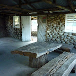
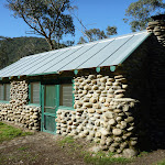
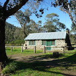
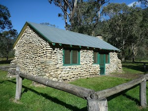
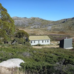
Keebles Hut
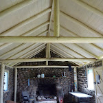
Keebles Hut was built in 1948[47] as a fishing lodge by Arthur Keeble, for Arthur and Flo Nankervis. The hut has been under the management of NPWS since 1970, with upkeep maintained by family members. A renovation was organised in 2002, by Kosciusko Huts Association and the Range Rover Club of NSW. The hut offers a fireplace[49] and a wood-powered stove[50], as well as a large indoor table[51]. Around the hut is a popular camping area, with picnic tables[52], a toilet[53] and a river nearby[54]. More info.
(1.04km) Int south of Keebles Hut → South side of Swampy Plains River
1.1 km
18 mins
13m
-21m
Hard track
Veer left: From the intersection, this walk heads west up the short rise[55] to soon bend right (keeping Keeble’s Hut below and some distance to your right[56]). Following the clear main trail, this walk ignores the side tracks[57] and after about 650m, the trail bends right[58] (ignoring the fainter left branch) to lead down a short but fairly steep bank[59] and through a clearing where the trail bends left. This trail then leads along this flood plain, soon coming to another clearing[60] (and camping area on the left) just before the Swampy Plain River crossing[61][62].
(2.09km) South side of Swampy Plains River → Int east of Old Geehi Hut
360 m
7 mins
12m
-2m
Hard track
Continue straight: From the clearing, this walk follows the trail across the rocky ford Swamp Plain River crossing[63]. This river is impassable after rain or snow melt, take care not to cross when the river is too high or too fast. Once on the other side[64], this walk follows the trail as it bends left and leads up through the open forest[65] for about 300m to find a clear three-way intersection marked with a ‘No Garbage Collection’ sign[66] (on your left).
(2.45km) Int east of Old Geehi Hut → Old Geehi Hut
280 m
5 mins
0m
-11m
Moderate track
Veer left: From the intersection, this walk heads north-west along the flat 4WD trail, towards the long range[67], initially keeping the ‘No Garbage Collection’ sign[68] to your left. The trail leads through the open forest[69] and soon comes to a grassy clearing[70] and the stone Old Geehi Hut[71].
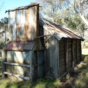
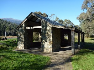
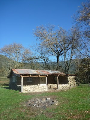
Old Geehi Hut
Old Geehi Hut (aka Youth Hostel, YHA Hut), was originally built in 1948[72] and restored after bushfires in 2003 by NPWS, the NSW Landrover Club and the Range Rover Club of NSW. The 7m x 4m river stone building has had a number of roles (and names) over the years, including private use (by the Nankervis and Mitchell families) and also a youth hostel. It has been managed by NPWS since 1977. The hut offers visitors a fireplace[73], an indoor picnic table[74] and there is a toilet[75] and camping nearby. More info.
Maps for the Old Geehi Hut tour walk
You can download the PDF for this walk to print a map.
These maps below cover the walk and the wider area around the walk, they are worth carrying for safety reasons.
| Kalkite Mountain | 1:25 000 Map Series | 86253N KALKITE MOUNTAIN | NSW-86253N |
| Tombong | 1:50 000 Map Series | 8624S TOMBONG | NSW-8624S |
| Numbla Vale | 1:50 000 Map Series | 8624N NUMBLA VALE | NSW-8624N |
| Youngal | 1:25 000 Map Series | 85253S YOUNGAL | NSW-85253S |
| Scammells Lookout | 1:25 000 Map Series | 85253N SCAMMELLS LOOKOUT | NSW-85253N |
| Berridale | 1:100 000 Map Series | 8625 BERRIDALE | 8625 |
| Kosciuszko | 1:100 000 Map Series | 8525 KOSCIUSZKO | 8525 |
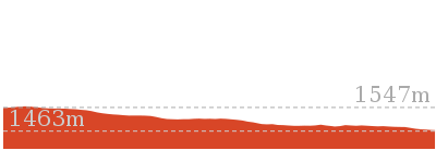
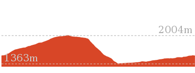
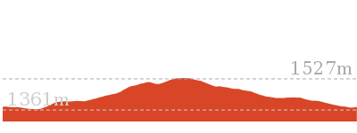
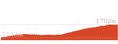
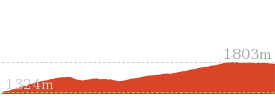
Cross sectional view of the Old Geehi Hut tour bushwalking track
Analysis and summary of the altitude variation on the Old Geehi Hut tour
Overview of this walks grade – based on the AS 2156.1 – 2001
Under this standard, a walk is graded based on the most difficult section of the walk.
| Length | 5.5 km | ||
| Time | 2 hrs | ||
| . | |||
| Grade 4/6 Hard track |
AS 2156.1 | Gradient | Short steep hills (3/6) |
| Quality of track | Rough track, where fallen trees and other obstacles are likely (4/6) | ||
| Signs | Minimal directional signs (4/6) | ||
| Experience Required | Moderate level of bushwalking experience recommended (4/6) | ||
| Weather | Forecast, unforecast storms and severe weather may impact on navigation and safety (4/6) | ||
| Infrastructure | Limited facilities (such as cliffs not fenced, significant creeks not bridged) (4/6) |
Some more details of this walks Grading
Here is a bit more details explaining grading looking at sections of the walk
Gradient
1.4km of this walk has short steep hills and another 850m is flat with no steps. The remaining (470m) has gentle hills with occasional steps.
Quality of track
2.3km of this walk follows a clear and well formed track or trail and another 360m follows a formed track, with some branches and other obstacles. The remaining (110m) follows a rough track, where fallen trees and other obstacles are likely.
Signs
2.3km of this walk has minimal directional signs and another 360m is clearly signposted. The remaining (60m) has directional signs at most intersection.
Experience Required
1.9km of this walk requires some bushwalking experience and another 470m requires a leader a with moderate level of bushwalking experience. The remaining (360m) requires no previous bushwalking experience.
weather
2.5km of this walk is affected by storms that may impact your navigation and safety and another 110m is affected by forecast, unforecast storms and severe weather events that may impact on navigation and safety. The remaining (85m) is not usually affected by severe weather events (that would unexpectedly impact safety and navigation).
Infrastructure
1.9km of this walk has limited facilities (such as not all cliffs fenced) and another 470m has limited facilities (such as cliffs not fenced, significant creeks not bridged). The remaining (360m) is close to useful facilities (such as fenced cliffs and seats).
Similar walks
A list of walks that share part of the track with the Old Geehi Hut tour walk.
2.6 km Circuit
1 Hr
Hard track
Other Nearby walks
A list of walks that start near the Old Geehi Hut tour walk.
3.3 km Return
1 hr 30 mins
Hard track

6 km Return
3 hrs
Very experienced only
17.4 km Return
8 hrs
Experienced only
25.8 km One way
2 Days
Experienced only
15.2 km One way
6 hrs 30 mins
Experienced only
6.4 km Return
2 hrs 45 mins
Moderate track

14.8 km Return
6 hrs 45 mins
Experienced only
6.4 km Return
2 hrs 30 mins
Moderate track
45 km Circuit
4 Days
Experienced only
9.3 km Return
4 hrs
Hard track
1.6 km Return
45 mins
Hard track
21.9 km Circuit
9 hrs
Hard track
Plan your trip to and from the walk here
The Old Geehi Hut tour walk starts and ends at the Geehi Hut car park (gps: -36.378036, 148.17949)
Your main transport option to Geehi Hut car park is by;
![]() Car. A park entry fee is required for driving into the park.
Car. A park entry fee is required for driving into the park.
(get details)
Short URL = http://wild.tl/oght
Gallery images
There are other downloads I am still working on.
You will probably need to login to access these — still all free.
* KML (google earth file)
* GPX (GPS file)
Special Maps/ brochures
* A3 topo maps
* PDF with Lands Topo map base
* PDF with arial image (and map overlay)
I wanted to get the main site live first, this extra stuff will come in time.
Happy walking
Matt 🙂
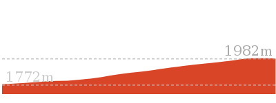
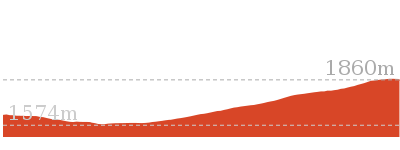
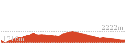
Kosciuszko walk – Thredbo to Mount Kosciuszko

6 hrs
12.4 km Return
459 m
Hard track
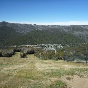
This popular walk starts with a ride up to the top of the Kosciuszko Express chairlift, and goes to the top of Mt Kosciuszko. From the top of the chairlift, the walk follows a footpath, passing the Kosciuszko and Cootapatamba lookouts, as it winds up to Rawson Pass. At Rawson Pass, the walk meets the old Kosciuszko road and Australia’s highest public toilet. From here, the walk continues up the footpath to the top of Mt Kosciuszko. Enjoy the view, and return the same way. If you would prefer the extra walk, you can avoid the chairlift by following Merrits Nature trail or the Dead Horse Gap track.


Covered in snow part of the year
This walk leads through an extreme alpine environment and all walkers must be well prepared. During summer, be prepared for both very hot and cold weather, high winds, rain, snow, extreme UV levels and some sections of snow or ice on the ground. Before starting this walk, check advice with Snowy Region Visitor Information Centre (02) 6450 5600, the weather forecast and the snow conditions then change your plans as needed. These notes, grades and walking times have been written for use in the summer months only. Between May and the end of October, this walk is likely to be covered in snow/ice, visitors should be carrying and be prepared to use snowshoes or cross country skis. When there is a chance of significant snow on the ground, visitors will need particularly strong navigation and snowcraft skills – tracks and signage may not be visible. For most visitors, it is best to consider this walk closed during the colder months.
Kosciuszko Express Chairlift
This is one of the few lifts operating in the summer months at Thredbo, and is made quite popular by thousands of people walking to the summit of Mt Kosciuszko each year. Lift tickets can be purchased from the store at the bottom of the chairlift. Lift tickets are $31 return ($25 one way) per person. This lift is generally closed during November and May for maintenance each year, but the the Snowgum chair can be used at this time instead, this will add extra walking time to you walk. More info.
(0km) Bottom of Kosciuszko Express chairlift → Top of Kosciuszko Express chairlift
1.9 km
20 mins
558m
-1m
Very easy
This walk heads into the ‘Valley Terminal’ building, where you can buy a ticket for the lift. Continue through the building and up the steps, where this walk turns right to find the bottom terminal of the ‘Kosciuszko Express’. Walk up to the platform as directed by the chairlift operator and sit down in the seat, letting it scoop you up. Once seated, pull down the safety bar and enjoy the ride to the top of the ridge. 🙂
At the top step of the chair lift and turn left to find the restaurant (now on your right) and track information signs ahead.
At the top step of the chair lift and turn left to find the restaurant (now on your right) and track information signs ahead.
Eagles Nest Restaurant
This is Australia’s highest restaurant, providing great food and outstanding views. It is easily accessible, nestled on the mountain directly opposite the top of the Kosciuszko Express chairlift, and is open year-round. For more information, call (02) 64576019.
(1.86km) Top of Kosciuszko Express chairlift → Int of Dead Horse Gap track and Kosciuszko footpath
350 m
6 mins
23m
0m
Moderate track
Turn right: From the top of the chairlift[3], this walk follows the footpath around Eagles Nest restaurant[4][5] (keeping the building to your right). The walk passes the large map[6] and information signs[7], heading up the gentle hill along the paved path[8]. Near the top of the rise, the path leads to a signposted intersection with the ‘Dead Horse Gap’ track[9] (on your left), where there is also an arrow pointing back to ‘Eagles Nest Restaurant’[10].
(2.21km) Int of Dead Horse Gap track and Kosciuszko footpath → Start of metal walkway
200 m
3 mins
1m
-7m
Hard track
Continue straight: From the intersection, this walk follows the ‘Mt Kosciuszko Lookout’ sign[11] north along the paved path, heading up the gentle hill. The path soon leads past an alcove with two information signs[12], then leads gently downhill to cross a river on a steel bridge[13] to find an intersection (with a narrow track on your right) at a lovely spot beside the creek.
(2.41km) Start of metal walkway → Int of Kosciuszko path and lookout walkway
1.3 km
31 mins
117m
0m
Hard track
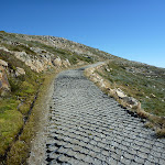
Continue straight: From the intersection, this walk heads away from the bridge and up the metal steps, keeping the creek to your left. The path soon leads past a large ‘Kosciuszko Walk’ sign[14] and an ‘Everything is connected’ information sign[15]. Soon after the ‘Thredbo 1.0km’ badge[16][17] (welded to the track), this walk comes to a ‘Plant communities – keeping a low profile’ information sign[18], marking an intersection (where the snow-pole line starts to leave the main track)[19].
Continue straight: From the intersection, the walk continues along the metal walkway, heading up the hill[20]. The walk soon passes a ‘Flowers emerge with warmer weather’ information sign[21], then heads up a series of steps to find ‘A rocky mountain home’ information sign[22] and a ‘Thredbo 1.5km’ tag[23] pointing back down the hill. The track mostly flattens out and heads over a gentle rise, soon leading to a clear ‘Y’ intersection[24] on the metal track, marked with ‘Mt Kosciuszko Lookout’ tag[25] welded to the track.
Continue straight: From the intersection, the walk continues along the metal walkway, heading up the hill[20]. The walk soon passes a ‘Flowers emerge with warmer weather’ information sign[21], then heads up a series of steps to find ‘A rocky mountain home’ information sign[22] and a ‘Thredbo 1.5km’ tag[23] pointing back down the hill. The track mostly flattens out and heads over a gentle rise, soon leading to a clear ‘Y’ intersection[24] on the metal track, marked with ‘Mt Kosciuszko Lookout’ tag[25] welded to the track.
(3.69km) Int of Kosciuszko path and lookout walkway → Kosciuszko lookout
50 m
1 mins
0m
-1m
Hard track
Veer right: From the intersection[26], this walk heads north-east along the metal path that branches off the main path. The path leads a short distance up some steps[27] to soon come to the metal platform at the Kosciuszko lookout[28][29]. At the end of this side trip, retrace your steps back to the main walk then Turn sharp right.
Kosciuszko lookout
Kosciuszko lookout is about 30m off the main Kosciuszko walk, along a metal walkway. At the lookout, there is a larger platform with an information sign about how the landscape was formed over the years. Granting a great view of the Snowy Mountains to the summit of Mt Kosciuszko.
(3.69km) Int of Kosciuszko path and lookout walkway → Lake Cootapatamba lookout
1.9 km
40 mins
94m
-45m
Hard track
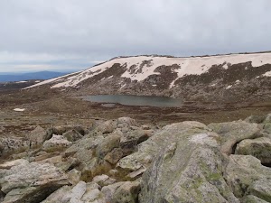
Continue straight: From the intersection, this walk follows the metal walkway north, down the gentle hill (initially keeping Mt Kosciuszko lookout to your right). The walk continues along the metal walkway as it dips to cross the upper reaches of the Snowy River. About 400m past the ‘Endangered Mammals Live between boulders’ sign[30], the path leads to a faint intersection with the North Rams Head track (where the spur comes down to the metal walkway on your left).
Continue straight: From the intersection, this walk follows the metal walkway north into the saddle and up the spur. The path then crosses onto the left-hand side of the ridge as it comes to the signposted ‘Lake Cootapatamba Lookout’[31] and the great valley view[32].
Continue straight: From the intersection, this walk follows the metal walkway north into the saddle and up the spur. The path then crosses onto the left-hand side of the ridge as it comes to the signposted ‘Lake Cootapatamba Lookout’[31] and the great valley view[32].
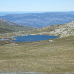
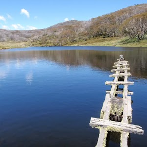
Lake Cootapatamba lookout
Situated on the Kosciuszko walk, this platform looks down over Lake Cootapatamba, in the valley on the western side of the path. This is a pleasant place to stop and enjoy the mountains and views.
(5.62km) Lake Cootapatamba lookout → Rawson Pass
790 m
14 mins
16m
-6m
Hard track
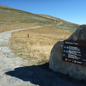
Rawson Pass

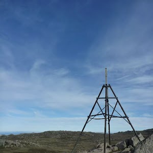
Rawson Pass is where the old Kosciuszko Road, from Charlotte Pass, meets the metal walkway from Thredbo. It is home to highest public toilet in Australia, this recently-added facility is perfectly positioned for those taking the walk up to the top of Kosciuszko. Rawson Pass is well signposted and 500m south east of Mt Kosciuszko (by straight line). There is also a place for to park mountain bikes for those cycling along the old road from Charlotte Pass.
(6.41km) Rawson Pass → Mt Kosciuszko
1.6 km
39 mins
127m
-23m
Hard track
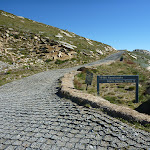
Veer left: From the intersection at Rawson Pass, this walk follows the ‘Mt Kosciuszko’ sign[38] uphill along the stone pathway. The stone pathway soon becomes a gravel track and winds up and around the hill, keeping the peak of Mt Kosciuszko to your left. About 500m along the gravel track, this walk comes to a ‘Y’ intersection[39] (with the Kosciuszko summit track on your left), just past the ‘Alpine Walks’ sign and map[40].
Veer left: From the intersection, this walk follows the ‘Mt Kosciuszko’ sign[41] uphill along the upper track. This track winds steadily up and around the peak of the mountain, passing a stone-paved[42] section of track, and also a metal grate[43] before climbing a few steps[44] to the cairn at the peak of Mt Kosciuszko[45].
Veer left: From the intersection, this walk follows the ‘Mt Kosciuszko’ sign[41] uphill along the upper track. This track winds steadily up and around the peak of the mountain, passing a stone-paved[42] section of track, and also a metal grate[43] before climbing a few steps[44] to the cairn at the peak of Mt Kosciuszko[45].
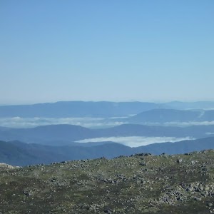
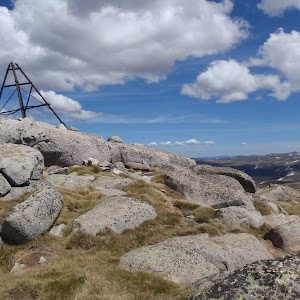
Mt Kosciuszko

Mt Kosciuszko is the highest peak on the Australian continent, at 2228m above sea level. It was named by the Polish explorer Count Paul Edmund Strzelecki and named in honour of the Polish national hero General Tadeusz Kościuszko. Now a popular tourist attraction, thousands of people walk up to the summit each year. On a clear day, the 360-degree views from the summit across the roof of Australia are fantastic. There are higher mountains elsewhere on Australian territory. ‘The highest mountains in Australian Antarctic Territory are Mt McClintock (3490 meters) and Mt Menzies (3355 meters).’ .
Maps for the Kosciuszko walk – Thredbo to Mount Kosciuszko walk
You can download the PDF for this walk to print a map.
These maps below cover the walk and the wider area around the walk, they are worth carrying for safety reasons.
| Perisher Valley | 1:25 000 Map Series | 85252S PERISHER VALLEY | NSW-85252S |
| Chimneys Ridge | 1:25 000 Map Series | 85241N CHIMNEYS RIDGE | NSW-85241N |
| Kosciuszko | 1:100 000 Map Series | 8525 KOSCIUSZKO | 8525 |
| Jacobs River | 1:100 000 Map Series | 8524 JACOBS RIVER | 8524 |
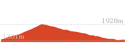
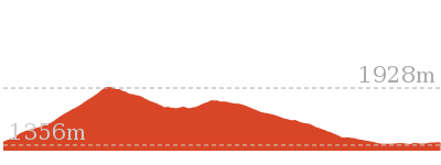
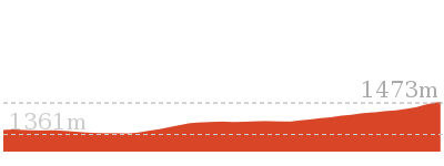
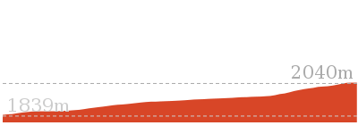
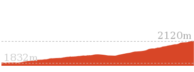
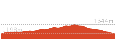
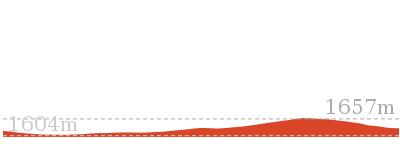
Cross sectional view of the Kosciuszko walk – Thredbo to Mount Kosciuszko bushwalking track
Analysis and summary of the altitude variation on the Kosciuszko walk – Thredbo to Mount Kosciuszko
Overview of this walks grade – based on the AS 2156.1 – 2001
Under this standard, a walk is graded based on the most difficult section of the walk.
| Length | 12.4 km | ||
| Time | 6 hrs | ||
| . | |||
| Grade 4/6 Hard track |
AS 2156.1 | Gradient | Short steep hills (3/6) |
| Quality of track | Clear and well formed track or trail (2/6) | ||
| Signs | Clearly signposted (1/6) | ||
| Experience Required | No experience required (1/6) | ||
| Weather | Forecast, unforecast storms and severe weather may impact on navigation and safety (4/6) | ||
| Infrastructure | Generally useful facilities (such as fenced cliffs and seats) (1/6) |
Some more details of this walks Grading
Here is a bit more details explaining grading looking at sections of the walk
Gradient
4.5km of this walk has gentle hills with occasional steps and another 2.8km is flat with no steps. The remaining (690m) has short steep hills.
Quality of track
Around 6km of this walk follows a clear and well formed track or trail, whilst the remaining 2.4km follows a smooth and hardened path.
Signs
This whole walk, 8km is clearly signposted.
Experience Required
This whole walk, 8km requires no previous bushwalking experience.
weather
6km of this walk is affected by forecast, unforecast storms and severe weather events that may impact on navigation and safety and another 1.9km is not usually affected by severe weather events (that would unexpectedly impact safety and navigation). The remaining (350m) is affected by storms that may impact your navigation and safety.
Infrastructure
This whole walk, 8km is close to useful facilities (such as fenced cliffs and seats).
Similar walks
A list of walks that share part of the track with the Kosciuszko walk – Thredbo to Mount Kosciuszko walk.
3.7 km Circuit
2 hrs 30 mins
Hard track
3.8 km Return
2 hrs 30 mins
Hard track
5.3 km One way
3 hrs
Hard track
5.8 km Circuit
3 hrs
Hard track
7.5 km Return
3 hrs 45 mins
Hard track
9.8 km Circuit
4 hrs 30 mins
Hard track
10.1 km Circuit
5 hrs
Hard track
12.2 km One way
5 hrs
Hard track

18.5 km Return
6 hrs
Hard track
21.9 km Circuit
9 hrs
Hard track
25.8 km One way
2 Days
Experienced only
27.7 km Circuit
2 Days
Experienced only
45 km Circuit
4 Days
Experienced only
Other Nearby walks
A list of walks that start near the Kosciuszko walk – Thredbo to Mount Kosciuszko walk.
3.1 km Circuit
1 hr 30 mins
Hard track
3.3 km Circuit
1 hr 15 mins
Moderate track
2.2 km Return
1 Hr
Hard track
3.3 km Circuit
1 hr 15 mins
Moderate track
4.8 km One way
1 hr 45 mins
Moderate track
4.7 km Return
2 hrs
Moderate track
2.9 km Circuit
1 hr 15 mins
Moderate track
4.1 km Return
1 hr 45 mins
Moderate track
9.7 km Return
4 hrs
Hard track
19.6 km Return
7 hrs 30 mins
Hard track
778 m Return
30 mins
Moderate track
2.4 km Return
1 hr 30 mins
Hard track
Plan your trip to and from the walk here
The Kosciuszko walk – Thredbo to Mount Kosciuszko walk starts and ends at the Bottom of Kosciuszko Express chairlift (gps: -36.503981, 148.30397)
Your main transport option to Bottom of Kosciuszko Express chairlift is by;
![]() Car. A park entry fee is required for driving into the park.
Car. A park entry fee is required for driving into the park.
(get details)
Short URL = http://wild.tl/ttmkr
Gallery images
There are other downloads I am still working on.
You will probably need to login to access these — still all free.
* KML (google earth file)
* GPX (GPS file)
Special Maps/ brochures
* A3 topo maps
* PDF with Lands Topo map base
* PDF with arial image (and map overlay)
I wanted to get the main site live first, this extra stuff will come in time.
Happy walking
Matt 🙂
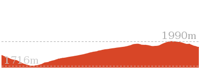
Pallaibo Walk
And Walk
Pallaibo Walk

2 hrs 30 mins
5.5 km One way
114 m
Hard track
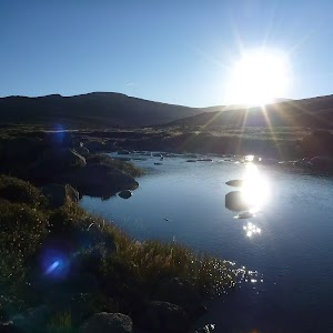
This wonderful walk explores the lower half of Sawpit Creek. Starting from high up on Kosciuszko Road at the Sawpit Creek Picnic Area, you will follow the well signposted track as it follows Sawpit Creek through the valley. You will explore various forest types as you make you way down to the Thredbo River. The walk finish with a stroll along the Thredbo River to find the well established Thredbo River Picnic Area. Plan ahead to organise a lift from the end of this walk or allow extra time to walk back up.


Snow & Ice on walk
This walk leads through an alpine environment and all walkers must be well prepared. During summer, be prepared for both hot and cold weather, high winds, rain, extreme UV levels and some sections of snow or ice on the ground. Before starting this walk, check advice with Snowy Region Visitor Information Centre (02) 6450 5600, the weather forecast and the snow conditions then change your plans as needed. These notes, grades and walking times have been written for use in the summer months only. Between May and the end of October, there is a much higher change of snow, ice and extremely cold conditions.
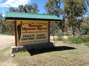
Kosciuszko Mountain Retreat
The ‘Kosciuszko Mountain Retreat’ is a caravan park about 1km further into Kosciuszko NP from the paystation on Kosciuszko Rd. The retreat provides cabins and chalets as well as powered and un-powered camping sites. The retreat has a public phone[1], a small kiosk[2], drying room[3], laundry and kids playground. Dave and Gina welcome guests all year round, with many guest skiing in winter and walking in the warmer months. More info.
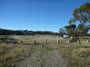
Sawpit Creek Picnic Area
Sawpit Creek Picnic Area is found beside Kosciuszko Rd, and is accessed through the ‘Kosciuszko Mountain Retreat’ driveway[4]. The picnic area is about 1km further into the park from the NPWS pay station. A great starting point for several popular walks, this is also a pleasent spot to just stop and rest. Sawpit Creek[5] runs along the side of the open area and there are also several picnic tables[6], wood BBQs[7] and a non-flush toilet[8]. There are information signs about the area, explaining that the creek is named for the Alpine Ash that were milled in the area during the 1860s [9].
(0km) Sawpit Creek Picnic Area → Sawpit intersection
50 m
1 mins
0m
-2m
Very easy
Kosciuszko Education Centre
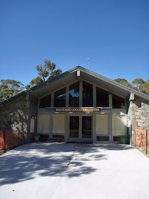
The Kosciuszko Education Centre is a facility at Sawpit Creek that helps students from primary school through to university learn about the natural and cultural heritage within the national park. The building has a display with some information for visitors[16], but it is not designed to be a general visitor information centre. You can call the Kosciuszko Education Centre on 6451 3700. More info.
(0.05km) Kosciuszko Education Centre → Sawpit intersection
310 m
6 mins
0m
-11m
Very easy
Turn sharp left: From the front of the large stone ‘Kosciuszko Education Centre’[17], this walk heads across the car park towards the timber building[18] (keeping Kosciuszko Rd, some distance to your right). The walk then veers left just before the timber building to find the large metal ‘Kosciuszko Education Centre’ sign[19] with arrows pointing to various walks. This walk follows these arrows along the paved footpath[20] and after about 100m, the path doglegs past a couple of bench seats[21]. The walk continues down this path for another 150m to a T-intersection[22] marked with a ‘Pallaibo track’ information sign[23] (and a bridge on your right[24]). Now Turn left to join the main walk.
(0.05km) Sawpit intersection → Powerline Clearing
490 m
9 mins
5m
-16m
Moderate track
Veer right: From the intersection, this walk follows the ‘Pallaibo Track’ and ‘Sawpit Track’ signs[25] along the dirt track, directly away from the bridge. The track leads along the side of the valley[26] and after about 260m, crosses a short metal grate[27] and then, about 150m later, leads down through the granite boulders[28]. Next, the track leads down some timber steps[29] to cross Sawpit Creek on a flat timber bridge[30]. On the other side of the bridge, the track bends left and heads over a small rise, soon coming to a clearing underneath a set of power lines[31] (and fenced water treatment area up to your right).
(0.54km) Powerline Clearing → Sawpit Valley View
440 m
9 mins
6m
-28m
Moderate track
Continue straight: From the intersection, this walk crosses under the power lines and follows the clear narrow track[32] along the side of the hill, whilst initially keeping the fenced water treatment area up to your right. The walk winds gently through the forest, passing a couple of timber posts[33] with walking track symbols, heads over a rise then down to cross a small gully with a metal grate[34], about 200m from passing under the power lines. The track continues gently downhill and after about 160m, it bends sharply right[35] to follow the steep side of Sawpit Creek valley[36]. The walk soon comes to a signposted three-way intersection[37] (with an unfenced valley view on your left[38]) and a few ‘Pallaibo Track’ signs[39].
Sawpit Valley View

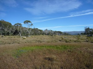
At the intersection about halfway around Sawpit Track (where it joins Pallaibo Track) is an unfenced view[40] into the Sawpit Creek valley. From the rocky edge, walkers can look up and down the valley[41]. Looking down the valley, there is a view of Bald Mountain (1300m) and a glimpse over the Thredbo River into the adjoining farmland.
(0.99km) Sawpit Valley View → Sawpit Falls view
1.2 km
29 mins
26m
-101m
Hard track
Continue straight: From the intersection, this walk follows the ‘Pallaibo Track to Thredbo River 4 KM’ sign[42] downhill, keeping the main valley to your left. The track leads fairly steeply down for about 130m, passing through several switchbacks[43][44]. The track then essentially flattens out[45] and leads along the valley for a few hundred metres to find a metal bridge[46]. The walk crosses the bridge over Sawpit Creek[47], then turns right, heading over a gentle rise[48]. The walk continues gently down though the open eucalypt forest[49] and, about 800m from the bridge, this walk comes to an unfenced view point[50] looking down to a waterfall[51] on Sawpit Creek (this is just before the track heads down some stone steps[52]).
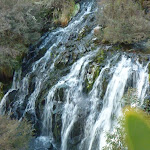
Sawpit Falls view
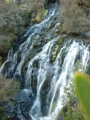
Sawpit Falls view is found on the rocky edge of a steep cliff of Pallaibo Track. The unfenced view looks between two trees[53], peering down into the Sawpit Creek Valley to a large waterfall cascading down the wide rockface. The waterfall is some distance[54] away and the view is filtered through the trees, but it is still worth stopping to enjoy.
(2.14km) Sawpit Falls view → Lower Sawpit Creek Bridge
1.8 km
47 mins
26m
-184m
Hard track
Veer left: From the view point[55], this walk follows the stone steps[56] downhill, keeping the main valley to your right. After about 150m of leading down the side of the gully, the track leads through a right-hand switchback[57] then soon crosses Sawpit Creek on a metal bridge[58]. Here the track heads left, leading about 200m further down along the valley floor before heading down some timber steps[59]. A further 400m along the track, the walk comes to a ‘3K’ timber milestone post[60]. The track starts to lead a little more steeply downhill for the next 500m, as it passes through a granite outcrop[61] and down a series of steps, and then bends around a left-hand switchback[62]. The track starts to get steeper and winds down the hill through some sharp bends for about 250m before passing another right-hand switchback[63]. Still fairly steep for another hundred metres or so, the track then essentially flattens out to come to a large grassy clearing[64]. Across the Thredbo River is a view to the Gaden Trout Hatchery is a NSW Government facility for breeding Atlantic salmon, brook, brown and rainbow trout for recreational fishing. Here, the fainter track leads down the clearing, tending left and leading back into the trees[66] to a flat metal footbridge over Sawpit Creek[67].
(3.97km) Lower Sawpit Creek Bridge → Thredbo River Picnic Area
1.5 km
32 mins
51m
-66m
Moderate track
Continue straight: From here, the walk crosses Sawpit Creek on the flat metal bridge[68] and follows the track up the steps to cross a grassy clearing. The walk climbs over a rise then down the other side to pass a ‘5K’ timber milestone[69], about 1km from the bridge. The walk continues down the hill and steps, and soon follows the bank of the Thredbo River[70]. Keeping the river a short distance to your right, this track leads past a few rock falls[71] before coming to edge of the Thredbo River Picnic Area[72]. Here the walk heads up towards the toilet block[73] and follows the footpath[74] down past the stone picnic shelter[75] (and information signs) to the car park. The picnic area is where Kosciuszko Rd crosses the Thredbo River.
Thredbo River Picnic Area
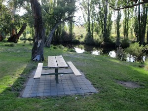
The Thredbo River Picnic Area, as the name suggests, sits on the northern bank of the Thredbo River[76]. The picnic area is just within the bounds of Kosciuszko National Park and is signposted on Kosciuszko Rd[77]. There are well covered (and uncovered) BBQs[78] and picnic tables[79], as well as a toilet block[80][81] and open grassy area[82]. There is a large car park[83] and paved path[84] linking the main facilities. Sitting at the lower end of Pallaibo Track[85], this is a popular spot for people walking, fishing and enjoying this gateway to the national park.
Maps for the Pallaibo Walk walk
You can download the PDF for this walk to print a map.
These maps below cover the walk and the wider area around the walk, they are worth carrying for safety reasons.
| Kalkite Mountain | 1:25 000 Map Series | 86253N KALKITE MOUNTAIN | NSW-86253N |
| Tombong | 1:50 000 Map Series | 8624S TOMBONG | NSW-8624S |
| Numbla Vale | 1:50 000 Map Series | 8624N NUMBLA VALE | NSW-8624N |
| Berridale | 1:100 000 Map Series | 8625 BERRIDALE | 8625 |
Cross sectional view of the Pallaibo Walk bushwalking track
Analysis and summary of the altitude variation on the Pallaibo Walk
Overview of this walks grade – based on the AS 2156.1 – 2001
Under this standard, a walk is graded based on the most difficult section of the walk.
| Length | 5.5 km | ||
| Time | 2 hrs 30 mins | ||
| . | |||
| Grade 4/6 Hard track |
AS 2156.1 | Gradient | Very steep (4/6) |
| Quality of track | Formed track, with some branches and other obstacles (3/6) | ||
| Signs | Directional signs along the way (3/6) | ||
| Experience Required | Some bushwalking experience recommended (3/6) | ||
| Weather | Storms may impact on navigation and safety (3/6) | ||
| Infrastructure | Limited facilities, not all cliffs are fenced (3/6) |
Some more details of this walks Grading
Here is a bit more details explaining grading looking at sections of the walk
Gradient
3km of this walk is very steep and another 1.5km has short steep hills. Whilst another 940m has gentle hills with occasional steps and the remaining 50m is flat with no steps.
Quality of track
Around 5km of this walk follows a formed track, with some branches and other obstacles, whilst the remaining 50m follows a smooth and hardened path.
Signs
Around 4.9km of this walk has directional signs at most intersection, whilst the remaining 540m is clearly signposted.
Experience Required
Around 4.5km of this walk requires some bushwalking experience, whilst the remaining 990m requires no previous bushwalking experience.
weather
Around 4.9km of this walk is affected by storms that may impact your navigation and safety, whilst the remaining 540m is not usually affected by severe weather events (that would unexpectedly impact safety and navigation).
Infrastructure
Around 3.4km of this walk has limited facilities (such as not all cliffs fenced), whilst the remaining 2km is close to useful facilities (such as fenced cliffs and seats).
Similar walks
A list of walks that share part of the track with the Pallaibo Walk walk.
2.2 km Circuit
45 mins
Moderate track
Other Nearby walks
A list of walks that start near the Pallaibo Walk walk.

5.8 km Circuit
2 hrs 15 mins
Moderate track
12.8 km Return
5 hrs
Hard track
2.5 km Return
1 Hr
Moderate track
14.1 km Circuit
5 hrs 30 mins
Hard track
22.4 km Return
9 hrs
Hard track
5.2 km One way
2 hrs 45 mins
Hard track
3.3 km Return
1 hr 30 mins
Hard track
6 km Return
3 hrs
Very experienced only
17.4 km Return
8 hrs
Experienced only
25.8 km One way
2 Days
Experienced only
15.2 km One way
6 hrs 30 mins
Experienced only
6.4 km Return
2 hrs 45 mins
Moderate track
Plan your trip to and from the walk here
The Pallaibo Walk walk starts at the Sawpit Creek Picnic Area (gps: -36.350229, 148.56435)
Your main transport option to Sawpit Creek Picnic Area is by;
![]() Car. A park entry fee is required for driving into the park.
Car. A park entry fee is required for driving into the park.
(get details)
The Pallaibo Walk ends at the Thredbo River Picnic Area (gps: -36.369401, 148.5892)
Your main transport option to Thredbo River Picnic Area is by;
![]() Car. A park entry fee is required for driving into the park.
Car. A park entry fee is required for driving into the park.
(get details)
Short URL = http://wild.tl/ptb
Gallery images
There are other downloads I am still working on.
You will probably need to login to access these — still all free.
* KML (google earth file)
* GPX (GPS file)
Special Maps/ brochures
* A3 topo maps
* PDF with Lands Topo map base
* PDF with arial image (and map overlay)
I wanted to get the main site live first, this extra stuff will come in time.
Happy walking
Matt 🙂
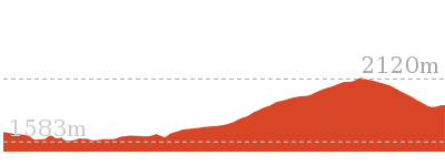
Rennix Trail
And Walk
Rennix Trail

5 hrs
12.8 km Return
411 m
Hard track
This enjoyable walk follows an old management trail from Rennix Gap to the panoramic views from a granite outcrop, which is also home to a Snowy Hydro radio repeater. On this walk, you will visit a variety of environments from open grassy plains, wooded forest, exposed granite outcrops and alpine fens.


Covered in snow part of the year
This walk leads through an extreme alpine environment and all walkers must be well prepared. During summer, be prepared for both very hot and cold weather, high winds, rain, snow, extreme UV levels and some sections of snow or ice on the ground. Before starting this walk, check advice with Snowy Region Visitor Information Centre (02) 6450 5600, the weather forecast and the snow conditions then change your plans as needed. These notes, grades and walking times have been written for use in the summer months only. Between May and the end of October, this walk is likely to be covered in snow/ice, visitors should be carrying and be prepared to use snowshoes or cross country skis. When there is a chance of significant snow on the ground, visitors will need particularly strong navigation and snowcraft skills – tracks and signage may not be visible. For most visitors, it is best to consider this walk closed during the colder months.
Rennix Gap
Rennix Gap is a signposted[1] saddle on the Kosciuszko Road and is home to a car park[2], picnic table[3] and the Rennix Walk trackhead[4]. The gap is named after W.E. Rennix, who was appointed the Shire Engineer (with a salary of £350 per year) and was the first to survey the road to Kosciuszko. The road was constructed between 1906-09. A sign at the trackhead reports that Rennix died from pneumonia after having been caught in a blizzard at the gap[6].
(0km) Rennix Walk Car Park → Lakes Creek saddle
1.8 km
32 mins
43m
-14m
Hard track
From the car park[7] and picnic table[8], this walk heads around the timber posts[9] and follows the arrow[10] past the ‘Rennix Walk’ information sign[11], downhill along the old management trail. After about 100m, this walk crosses a creek[12], then a short time later turns right at a ‘Y’ intersection[13] (following an arrow[14]) up the gentle hill. Here the walk continues along the side of the hill, through a grove of trees[15] then winds up the side of the grassy valley[16]. After a while, the track bends left to cross the grassy flat and leads across a flat timber bridge[17]. The old management trail then leads up the hill and through another grove of snow gums[18], and about 400m after the timber bridge, this walk comes to a large flat saddle[19] with a small wetland[20] and views towards the main range[21] (on your left).
Lakes Creek saddle
This saddle (as with a few other saddles on the Rennix Walk) is home to a significant wetland. This ‘Alpine fen’ is fed mostly by ground water from the surrounding hills and is an important ecosystem. Please admire the wetlands from a distance, and remain on the main track.
(1.79km) Lakes Creek saddle → Large Gap
2.9 km
1 hr 2 mins
119m
-117m
Hard track
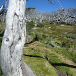
Continue straight: With the distant view to the main range on your left[23], this walk heads north, gently uphill following the old management trail[24]. The track soon leads through a gap in the trees to find another grassy clearing[25] and a ‘2K’ marker post[26]. Just past the post, the track leads past a water-bog[27], and then back into the trees[28]. The track winds through the lightly wooded area before turning right and heading up a short steep climb[29]. Once at the top of this climb, the track meanders for a little while before heading steeply[30] down, then winding around the side of the hill. Just as the track begins to climb again, it passes a ‘3K’ timber post[31]. For about 500m past the post, the track climbs up through the trees and granite boulders[32], to come to the top of a hill with a clearing[33] and a rocky outcrop[34]. Here, the track bends right and heads downhill, moderately steeply[35], just before crossing an open grassy saddle[36]. On the other side of this saddle, the track leads up the hill[37], and as the track climbs, the walk passes more and more dead snow gums, until on the top where most of the large trees are dead[38] and bleached[39]. Then, the track winds down the hill[40] to a larger open and grassy clearing in the saddle[41] below.
(4.71km) Large Gap → Giant’s Castle
720 m
17 mins
59m
-2m
Hard track
Continue straight: From the large clearing[42], this walk follows the old management trail north, moderately steeply[43] up the hill. Part way up the hill, the trees give way to a distant view of Lake Jindabyne[44] (to your right). The walk continues up the hill among the dead gum trees[45], where the track bends right to follow the ridge up past a scrubby clearing[46]. Continuing on, just past the large granite outcrop (the Giant’s Castle) with a metal trig station on top, the walk comes to a track[47] (on your left) leading up to the trig station[48].
(5.43km) Giant’s Castle → Radio repeater
970 m
19 mins
25m
-32m
Hard track
Continue straight: From the intersection (initially keeping the trig station and the Giant’s Castle to your left[52]), this walk heads north-east, following the old management trail along the ridge[53]. After about 130m, the track passes another granite outcrop and clearing[54] (on your left). The track then winds and gently undulates along the top of the ridge, passing among the trees and scattering of boulders[55] until coming to a large rock outcrop (on your right) with a flat green metal structure on top[56] – the radio repeater.
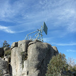
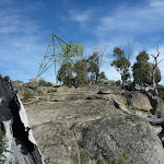
Radio repeater
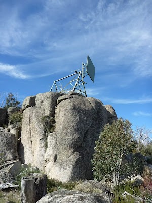
This high point, topped with a large granite boulder, provides a great view of the surrounding area. The rock is home to a large radio reflector[57]. This passive device acts like a mirror to bounce radio signals between two Snowy Hydro sites. The reflector looks like a billboard advertising green paint[58], but the simplicity of the design helps increase the reliability and reduce maintenance. There is also a small active, solar-powered repeater on site[59]. The rock behind the repeater slopes down to the ground[60], providing access to the base of the repeater and the great views. Take care on the rock, as there are no fences but a significant drop.
Maps for the Rennix Trail walk
You can download the PDF for this walk to print a map.
These maps below cover the walk and the wider area around the walk, they are worth carrying for safety reasons.
| Kalkite Mountain | 1:25 000 Map Series | 86253N KALKITE MOUNTAIN | NSW-86253N |
| Tombong | 1:50 000 Map Series | 8624S TOMBONG | NSW-8624S |
| Numbla Vale | 1:50 000 Map Series | 8624N NUMBLA VALE | NSW-8624N |
| Chimneys Ridge | 1:25 000 Map Series | 85241N CHIMNEYS RIDGE | NSW-85241N |
| Berridale | 1:100 000 Map Series | 8625 BERRIDALE | 8625 |
| Jacobs River | 1:100 000 Map Series | 8524 JACOBS RIVER | 8524 |
Cross sectional view of the Rennix Trail bushwalking track
Analysis and summary of the altitude variation on the Rennix Trail
Overview of this walks grade – based on the AS 2156.1 – 2001
Under this standard, a walk is graded based on the most difficult section of the walk.
| Length | 12.8 km | ||
| Time | 5 hrs | ||
| . | |||
| Grade 4/6 Hard track |
AS 2156.1 | Gradient | Short steep hills (3/6) |
| Quality of track | Clear and well formed track or trail (2/6) | ||
| Signs | Directional signs along the way (3/6) | ||
| Experience Required | Moderate level of bushwalking experience recommended (4/6) | ||
| Weather | Forecast, unforecast storms and severe weather may impact on navigation and safety (4/6) | ||
| Infrastructure | Limited facilities, not all cliffs are fenced (3/6) |
Some more details of this walks Grading
Here is a bit more details explaining grading looking at sections of the walk
Gradient
Around 3.6km of this walk has short steep hills, whilst the remaining 2.8km has gentle hills with occasional steps.
Quality of track
This whole walk, 6km follows a clear and well formed track or trail.
Signs
Around 4.6km of this walk has directional signs at most intersection, whilst the remaining 1.8km is clearly signposted.
Experience Required
Around 4.6km of this walk requires a leader a with moderate level of bushwalking experience, whilst the remaining 1.8km requires some bushwalking experience.
weather
This whole walk, 6km is affected by forecast, unforecast storms and severe weather events that may impact on navigation and safety.
Infrastructure
Around 4.6km of this walk has limited facilities (such as not all cliffs fenced), whilst the remaining 1.8km is close to useful facilities (such as fenced cliffs and seats).
Similar walks
A list of walks that share part of the track with the Rennix Trail walk.
Other Nearby walks
A list of walks that start near the Rennix Trail walk.
2.5 km Return
1 Hr
Moderate track
5.8 km Circuit
2 hrs 15 mins
Moderate track
5.5 km One way
2 hrs 30 mins
Hard track
2.2 km Circuit
45 mins
Moderate track
14.1 km Circuit
5 hrs 30 mins
Hard track
22.4 km Return
9 hrs
Hard track
5.2 km One way
2 hrs 45 mins
Hard track
3.3 km Return
1 hr 30 mins
Hard track
6 km Return
3 hrs
Very experienced only
17.4 km Return
8 hrs
Experienced only
25.8 km One way
2 Days
Experienced only
15.2 km One way
6 hrs 30 mins
Experienced only
Plan your trip to and from the walk here
The Rennix Trail walk starts and ends at the Rennix Walk Car Park (gps: -36.360475, 148.50654)
Your main transport option to Rennix Walk Car Park is by;
![]() Car. A park entry fee is required for driving into the park.
Car. A park entry fee is required for driving into the park.
(get details)
Short URL = http://wild.tl/1o
Gallery images
There are other downloads I am still working on.
You will probably need to login to access these — still all free.
* KML (google earth file)
* GPX (GPS file)
Special Maps/ brochures
* A3 topo maps
* PDF with Lands Topo map base
* PDF with arial image (and map overlay)
I wanted to get the main site live first, this extra stuff will come in time.
Happy walking
Matt 🙂
Porcupine Walk
And Walk
Porcupine Walk

2 hrs 30 mins
5.6 km Return
214 m
Hard track
Starting at the Perisher Valley Reservoir, this walk heads up through Rock Creek valley to the the panoramic views from Porcupine Rocks. On this walk, you will wander through button grass plains and among groves of snow gums whilst passing some granite tors. From the top of this walk, there are great views down both Perisher Valley and Thredbo River Valley as well as to Mt Duncan.


Covered in snow part of the year
This walk leads through an extreme alpine environment and all walkers must be well prepared. During summer, be prepared for both very hot and cold weather, high winds, rain, snow, extreme UV levels and some sections of snow or ice on the ground. Before starting this walk, check advice with Snowy Region Visitor Information Centre (02) 6450 5600, the weather forecast and the snow conditions then change your plans as needed. These notes, grades and walking times have been written for use in the summer months only. Between May and the end of October, this walk is likely to be covered in snow/ice, visitors should be carrying and be prepared to use snowshoes or cross country skis. When there is a chance of significant snow on the ground, visitors will need particularly strong navigation and snowcraft skills – tracks and signage may not be visible. For most visitors, it is best to consider this walk closed during the colder months.
(0km) End of Water Supply Storage Rd → Int of Porcupine and Link Track
1.1 km
23 mins
58m
-1m
Hard track
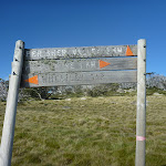
From the car park at the end of Water Supply Storage Road in Perisher Valley, this walk passes the ‘Porcupine Track’ sign[1] and crosses Rock Creek using the metal bridge. The walk then turns right and follows the next ‘Porcupine Track’ sign[2] towards the pump house[3]. At the pump house, this walk follows the narrow track on the other side of the building[4] and heads left, up past the reservoir[5]. Soon the track bends right and heads up the hill through the open grassland[6] following the line of snow poles. About 300m from the pump house, the track follows the first in a series of metal (erosion control) grates[7]. About 650m after this, the walk crosses Rock Creek again on a flat timber bridge then, 60m later, comes to a signposted three-way intersection with Porcupine Link Track (on your left)[8].
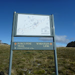
(1.13km) Int of Porcupine and Link Track → Int of Porcupine Trail and Wheatley Link Track
1.3 km
31 mins
109m
-7m
Hard track
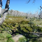
Continue straight: From the intersection, this walk follows the ‘Porcupine Trail’ sign[9] along the track and over the gentle rise heading south-west up the main wide valley. This track heads over a series of metal grates, leading through a few groves of dead snow gums to find a large and fairly flat saddle with a signposted intersection (with the ‘Wheatley Link Track’ on your right). The intersection is just past the new sign and before the older timber sign.
(2.46km) Int of Porcupine Trail and Wheatley Link Track → Porcupine Saddle
320 m
8 mins
25m
-7m
Hard track
Continue straight: From the intersection, this walk follows the ‘Porcupine’ trail signs[10][11] north-west over the top of the saddle and towards the large rocky pinnacle[12]. The track soon begins to steepen through a rocky area and, just after passing a large rocky outcrop[13] (on your left), the track leads up to a three-way intersection beside the gap[14] (on your left) between the two main peaks[15].
(2.78km) Porcupine Saddle → Porcupine Rocks
30 m
1 mins
0m
-7m
Hard track
Continue straight: From the intersection, this walk follows the track uphill[16] (away from the gap). The track soon bends left, then the walk scrambles over the rocks to find the pinnacle of Porcupine Rocks[17]. Be aware that these rocks can shift and may be slippery – do not climb beyond your capabilities.
Porcupine Rocks
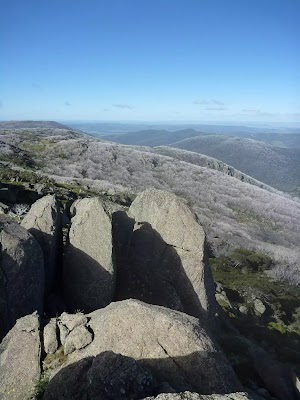
The Porcupine Rocks are a large granite outcrop on the ridge, south of Perisher Valley. There are two main peaks[18][19], and a rock scramble[20] leads to the top of the southern peak, providing fantastic views of Perisher Valley[21], Mt Duncan[22], Thredbo River Valley[23] and Bullocks Flat. The gap between the two summits provides some shade and protection from the wind. An amazing place to visit – allow time to just relax and enjoy this place. The summit can be slippery and icy, and there is a shear drop and other hazards. Much care is required.
Maps for the Porcupine Walk walk
You can download the PDF for this walk to print a map.
These maps below cover the walk and the wider area around the walk, they are worth carrying for safety reasons.
| Perisher Valley | 1:25 000 Map Series | 85252S PERISHER VALLEY | NSW-85252S |
| Chimneys Ridge | 1:25 000 Map Series | 85241N CHIMNEYS RIDGE | NSW-85241N |
| Kosciuszko | 1:100 000 Map Series | 8525 KOSCIUSZKO | 8525 |
| Jacobs River | 1:100 000 Map Series | 8524 JACOBS RIVER | 8524 |
Cross sectional view of the Porcupine Walk bushwalking track
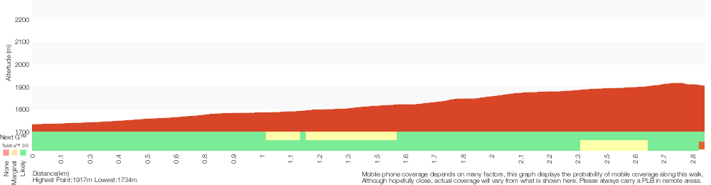
Analysis and summary of the altitude variation on the Porcupine Walk
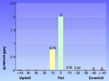
Overview of this walks grade – based on the AS 2156.1 – 2001
Under this standard, a walk is graded based on the most difficult section of the walk.
| Length | 5.6 km | ||
| Time | 2 hrs 30 mins | ||
| . | |||
| Grade 4/6 Hard track |
AS 2156.1 | Gradient | Very steep (4/6) |
| Quality of track | Rough track, where fallen trees and other obstacles are likely (4/6) | ||
| Signs | Minimal directional signs (4/6) | ||
| Experience Required | Moderate level of bushwalking experience recommended (4/6) | ||
| Weather | Forecast, unforecast storms and severe weather may impact on navigation and safety (4/6) | ||
| Infrastructure | Limited facilities (such as cliffs not fenced, significant creeks not bridged) (4/6) |
Some more details of this walks Grading
Here is a bit more details explaining grading looking at sections of the walk
Gradient
Around 2.5km of this walk has short steep hills, whilst the remaining 350m is very steep.
Quality of track
Around 2.5km of this walk follows a formed track, with some branches and other obstacles, whilst the remaining 350m follows a rough track, where fallen trees and other obstacles are likely.
Signs
2.5km of this walk is clearly signposted and another 320m has directional signs at most intersection. The remaining (30m) has minimal directional signs.
Experience Required
Around 2.5km of this walk requires some bushwalking experience, whilst the remaining 350m requires a leader a with moderate level of bushwalking experience.
weather
This whole walk, 2.8km is affected by forecast, unforecast storms and severe weather events that may impact on navigation and safety.
Infrastructure
2.5km of this walk is close to useful facilities (such as fenced cliffs and seats) and another 320m has limited facilities (such as not all cliffs fenced). The remaining (30m) has limited facilities (such as cliffs not fenced, significant creeks not bridged).
Similar walks
A list of walks that share part of the track with the Porcupine Walk walk.
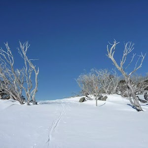
7.3 km Circuit
3 hrs
Hard track
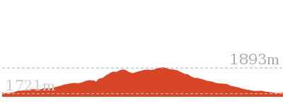
Other Nearby walks
A list of walks that start near the Porcupine Walk walk.
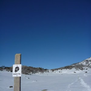
3 km Circuit
1 hr 30 mins
Moderate track
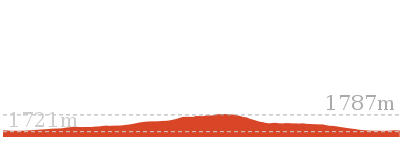
5.2 km One way
2 hrs 45 mins
Hard track

5.2 km Circuit
2 hrs
Moderate track
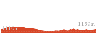
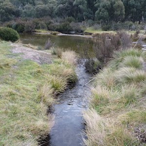
4.5 km Circuit
1 hr 30 mins
Moderate track
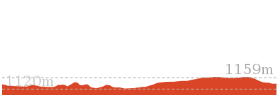
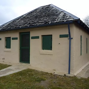
1.5 km Return
30 mins
Moderate track
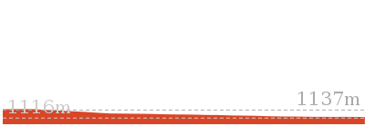
17.4 km Return
8 hrs
Experienced only
25.8 km One way
2 Days
Experienced only
15.2 km One way
6 hrs 30 mins
Experienced only
6.4 km Return
2 hrs 45 mins
Moderate track
14.8 km Return
6 hrs 45 mins
Experienced only
6.4 km Return
2 hrs 30 mins
Moderate track
45 km Circuit
4 Days
Experienced only
Plan your trip to and from the walk here
The Porcupine Walk walk starts and ends at the End of Water Supply Storage Rd (gps: -36.410871, 148.41016)
Your main transport option to End of Water Supply Storage Rd is by;
![]() Car. A park entry fee is required for driving into the park.
Car. A park entry fee is required for driving into the park.
(get details)
Short URL = http://wild.tl/pt
Gallery images
There are other downloads I am still working on.
You will probably need to login to access these — still all free.
* KML (google earth file)
* GPX (GPS file)
Special Maps/ brochures
* A3 topo maps
* PDF with Lands Topo map base
* PDF with arial image (and map overlay)
I wanted to get the main site live first, this extra stuff will come in time.
Happy walking
Matt 🙂
Munyang River Circuit
And Walk
Munyang River Circuit

5 hrs 30 mins
14.1 km Circuit
649 m
Hard track
This walk explores the alpine country and huts around the Munyang River. You will explore parts of the Snowy Mountains Scheme, starting with the Munyang /Guthega Power station, before climbing up the steep old road to find some great views down the valley. Optional side trips can take you to the Gate House, Horse Camp Hut and White’s River Hut, adding further variety to your day. Loop back to the start using the aqueduct trail down Disappointment Spur, visiting another hut on the way.
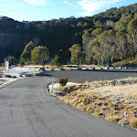
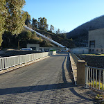
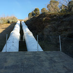


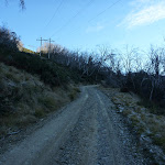
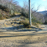


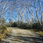
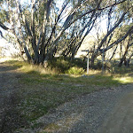
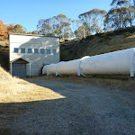
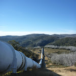
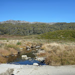
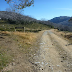
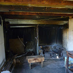

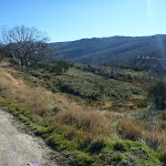

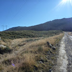

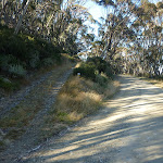
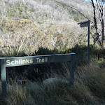

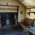

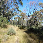

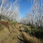


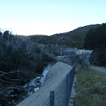
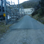
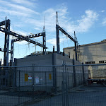
Covered in snow part of the year
This walk leads through an extreme alpine environment and all walkers must be well prepared. During summer, be prepared for both very hot and cold weather, high winds, rain, snow, extreme UV levels and some sections of snow or ice on the ground. Before starting this walk, check advice with Snowy Region Visitor Information Centre (02) 6450 5600, the weather forecast and the snow conditions then change your plans as needed. These notes, grades and walking times have been written for use in the summer months only. Between May and the end of October, this walk is likely to be covered in snow/ice, visitors should be carrying and be prepared to use snowshoes or cross country skis. When there is a chance of significant snow on the ground, visitors will need particularly strong navigation and snowcraft skills – tracks and signage may not be visible. For most visitors, it is best to consider this walk closed during the colder months.
(0km) Munyang car park → Behind Power station
190 m
5 mins
14m
-5m
Easy track
From the Munyang (Guthega Power Station) car park[1], this walk heads along the short driveway[2] and across the large bridge[3] over the Snowy River, heading towards the power station[4]. At the fence (on the other side of the bridge), this walk turns left[5] to head around to the other side of the power station. Just past the concrete building[6], this walk passes the two large feeder pipes[7] and continues, soon finding an intersection with two management trails[8] marked with a ‘Schlink Trail’ sign[9].
Guthega Power Station (Munyang)
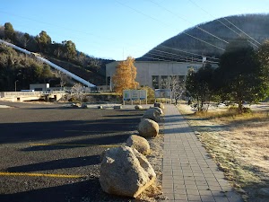
This was the first power station of the Snow Mountains Hydro Electric Scheme, completed in 1955. It is also known as Munyang, as the station sits just west of the confluence of the Munyang and Snowy Rivers. The station boasts two 30MW turbine and generator[11] combinations, providing peak power to the eastern states. The turbines are powered from the water in two large pipes[12] that form part of the Guthega Pressure Tunnel, fed by Guthega Dam. The dam is about 260m higher than the power station. More info.
(0.19km) Behind Power station → Pipe line intersection
1.3 km
35 mins
156m
-7m
Hard track
Turn left: From the intersection, this walk follows the ‘Schlink Trail’ sign[13] uphill along the sealed management trail[14]. This walk soon heads around a locked gate[15] where the trail becomes dirt[16]. The trail leads uphill quite steeply[17] and, after about 500m, leads under some power lines[18], around a sharp left bend[19] and then back under the same power lines again. The trail continues up, passing through two sharper bends[20] and under a different power line twice before flattening out at a right-hand bend[21] beside the large, white pipelines[22] (the Guthega Pressure Tunnel).
(1.46km) Pipe line intersection → int of Gate House trail and Munyang-geehi Rd
1 km
23 mins
78m
0m
Hard track
Continue straight: From the intersection, this walk heads gently uphill along the management trail, initially keeping the pipeline to your left[23]. The trail soon bends right, away from the pipeline, and heads through the trees. The walk passes under under a set of power lines[24] and continues along the clear management trail, past a signposted fainter trail[25]. About 500m after the power line, the trail bends left, ignoring another faint trail[26] (on your left) just beyond a clearing. Here the walk continues up through the snow gums[27] and soon after a left bend, comes to a clear three-way intersection, marked with a ‘Surge Tank’ and ‘Gate House’ signs[28] (pointing to the left).
(2.49km) Int of Gate House trail and Munyang-geehi Rd → Gate House
440 m
9 mins
9m
-24m
Hard track
Continue straight: From the intersection, this walk follows the ‘Surge Tank’ and ‘Gate House’ signs[29] south along the grassy management trail, over a small rise[30]. The trail leads though a clearing[31] and after about 170m, this walk takes the left branch at an intersection[32]. The trail soon starts to lead downhill[33], circling around behind the gate house building[34] and soon coming to the front of the building[35] where the large white pipes dominate the landscape[36]. At the end of this side trip, retrace your steps back to the main walk then Turn left.
Gate House
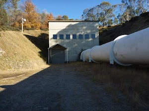
The gate house is a large concrete building, built into the side of the hill about 220m above Guthega Power Station. This building joins the underground Guthega pressure tunnel with the long white pipe that feed the power station. The gate house regulates the flow of water from the dam to the power station. There is some limited shelter and a great view along the pipe down to Munyang[37].
(2.49km) Int of Gate House trail and Munyang-geehi Rd → Int of Horse Camp Hut Trail and Munyang-geehi Rd
1.3 km
27 mins
40m
-63m
Hard track
Turn right: From the intersection, this walk heads west, downhill along the management trail, initially keeping the ‘Gate House’ and ‘Surge Tank’ trail to your left[38]. The trail bends right and crosses a small (culverted) creek[39] then winds over a small rise[40]. From the top of this rise, the trail leads downhill out of the snow gums[41] (passing a faint signposted trail, on your right[42]) to cross a fair sized creek[43] using a concrete ford[44]. Here the trail begins to climb again for about 500m (passing another faint signposted trail, on your right[45]), and just after passing through a grove of snow gums[46], the walk comes to the top of the rise and a three-way intersection marked with a ‘Horse Camp Hut’ sign[47] (pointing left).
(3.83km) Int of Horse Camp Hut Trail and Munyang-geehi Rd → Horse Camp Hut
510 m
10 mins
25m
-1m
Hard track
Veer left: From the intersection, this walk heads west following the ‘Horse Camp Hut – 400 meters’ sign[48] downhill along the management trail, directly away from the main trail and power lines[49]. The trail soon starts to head uphill through the trees and about 170m after a short but steeper climb[50], this trail leads to a small clearing and Horse Camp Hut[51], on your left. At the end of this side trip, retrace your steps back to the main walk then Turn sharp left.
Horse Camp Hut
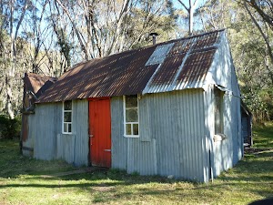
Horse Camp Hut is found beside a trail linking the old Munyang-Geehi Rd with an aqueduct trail on the western side of the valley. Still in good condition, this hut was built for surveyors in the 1950s as part of the Snowy Mountains Scheme effort. The hut has a distinctive red door[53] and two rooms. The smaller room contains bunk beds and a stove[54] and the larger room has a fire place, table and sitting area[55]. The hut has a timber floor[56] and the outer walls and roof are made of corrugated iron[57]. There is a creek nearby for water[58] and a pit toilet[59] is available. The grassy flat area around the hut makes for great camping[60].
(3.83km) Int of Horse Camp Hut Trail and Munyang-geehi Rd → Int of Aquaduct Trail and Munyang-geehi Rd
3.2 km
1 hr 7 mins
157m
-76m
Hard track
Continue straight: From the intersection, this walk heads north, downhill along the main management trail, keeping the valley and power lines to your right[61]. The trail almost immediately passes a ’97G-3′ sign[62] (pointing toward the power lines) and continues, crossing under the power lines twice[63] before crossing Munyang River on a concrete bridge[64] almost 1km after the ‘Horse Camp Hut’ sign. From here, the trail leads up the other side of the valley, crossing under the power lines again[65] before gently climbing up along the side of the valley. The trail crosses three small (culverted) creeks[66] and passes through a long run of dead snow gums[67]. Just past the third creek, the trail leaves the dead snow gums and climbs past the signposted ‘GGA-MSS 21 24’ trail[68] (on your left) and, about 400m later, comes to a signposted three-way intersection[69]. This intersection is signposted as ‘Disappointment Spur Trail’[70] (aka Aquaduct Trail) and ‘Schlinks Trail’[71] (aka Munyang-geehi Rd).
(6.98km) Int of Aquaduct Trail and Munyang-geehi Rd → White’s River Hut
1.3 km
31 mins
107m
-15m
Hard track
Continue straight: From the intersection, this walk follows the ‘Schlinks Trail’ sign[72] downhill along the management trail and soon crosses a (culverted) creek[73]. The trail passes an overgrown signposted trail[74] (on your left) and starts to climb the side of the hill, soon passing under a set of power lines[75] as the valley views open up[76]. The trail continues uphill for about 400m, passing a couple of rock falls[77] and also a clear management trail[78] (on your left). From here, the trail continues for another 400m, then flattens out and come to an unsignposted three-way intersection[79], just before a right-hand bend (and a ‘GGA-MSS 33’ sign[80]). Here you can see White’s River Hut and a weather station[81].
Turn left: From the intersection, this walk heads west, downhill along the grassy management trail towards the creek, and turns right almost immediately[82]. The clear trail soon leads through a rocky creek crossing[83] then over a small rise[84] tending left[85] to cross another creek[86]. These creeks may become impassable after rain or snow melt. The trail then leads up to a clearing and finds White’s River Hut[87]. At the end of this side trip, retrace your steps back to the main walk then Veer left.
Turn left: From the intersection, this walk heads west, downhill along the grassy management trail towards the creek, and turns right almost immediately[82]. The clear trail soon leads through a rocky creek crossing[83] then over a small rise[84] tending left[85] to cross another creek[86]. These creeks may become impassable after rain or snow melt. The trail then leads up to a clearing and finds White’s River Hut[87]. At the end of this side trip, retrace your steps back to the main walk then Veer left.
White’s River Hut
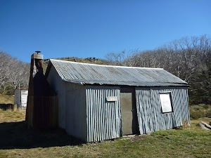
At this site, there are a few buildings – the main hut is believed to have been built in by Bill Napthali and Fred Clarke in 1935 to house them as they grazed cattle. It is also possible that the hut was built by Edward Haslingdon and his sons in 1933. The Kosciusko Alpine Club has a long history with the hut and has made many changes over the years – they are now the primary caretakers. This hut has two main rooms[91][92] plus an entry woodpile annex[93]. The second hut is behind the main hut – the SMA hut[94] (aka the Kelvinator). This second hut is not as well maintained[95] as the main one. There is also a pit toilet[96] beside the hut. A large, flat, grassy area[97] makes a great place to camp and the nearby creek is a source of water[98]. NOTE: On 27th July 2010 an accidental fire has done significant damage to this hut, it is now fenced off and accessing the hut is unsafe. A plan is likley to be put into place to restore the hut.
(6.98km) Int of Aquaduct Trail and Munyang-geehi Rd → Disappointment Spur Hut
3 km
1 hr 2 mins
123m
-94m
Hard track
Turn sharp right: From the intersection, this walk follows the ‘Disappointment Spur Trail’ sign[100] (and AAWT arrows[101]) uphill along the upper trail, keeping the valley (and lower trail) to your right[102]. The grassy trail climbs for a short while then flattens out[103], following the covered aqueduct (on your left). There are many numbered posts[104] and water collection points[105] along the way. After about 400m, the trail bends left and heads downhill to cross a creek using a concrete ford[106]. Here the trail climbs up through a run of dead snow gums[107]. The trail rises and falls, crossing a few small creeks[108] and crossing another creek and concrete ford[109], a little over 1km after the last ford. The trail climbs again, still through the dead gums[110], crossing a couple more creeks[111] before coming to a small clearing and hut[112] (about 130m after the creek marked with an orange ‘S29045’ post[113]).
Disappointment Spur Hut
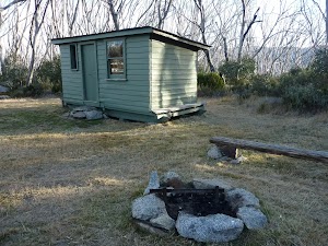
Disappointment Spur Hut was built in the 1950’s out of two standard accommodation modules, to support workers on the Snowy Mountains Scheme. The hut is in a small clearing[115] on the side of Disappointment Spur Trail (aka Aqueduct track). There is a supply of water from the nearby aqueduct[116] and a flat area for camping (no toilet). The hut is made from weatherboard with a flat tin roof, has a timber floor and three windows. There is a bunk bed[117] and a table[118] inside, and a fire circle outside[119].
(9.98km) Disappointment Spur Hut → Munyang car park
4.2 km
1 hr 32 mins
81m
-405m
Hard track
Continue straight: From the hut, this walk follows the management trail north-east[120] (initially keeping hut and valley to your right). The trail immediately bends left and follows beside the covered aqueduct around the side of the valley[121]. The trail leads over a few small creeks[122] and past water catchment devices[123] for the aqueduct. The trail leads up and down through a few small valleys and through the dead snow gum trees[124] but about 1.5km from the hut, the trail begins to head consistently downhill[125]. Further down the hill, the trail bends right[126] and passes beside a tall rock cutting[127], where there are great views up along the Munyang River[128] (to your right). The cutting continues for about 130m, bending left partway along. The walk then continues down the hill for another 600m where it passes around a locked gate[129] to find a large clearing[130] under the power lines[131] and a ‘Disappointment Spur Trail’ sign[132]. The walk continues straight across the timber bridge[133] WARNING: Bridge has been destroyed and not replaced. No passable, bending left to follow a fence[134] to the switching yard[135] and sealed section of road[136]. The walk continues along the sealed road beside the switching yard and soon comes to a clear intersection[137] behind the power station marked with a ‘Schlink Trail’ sign[138] (pointing up another trail).
Continue straight: From the intersection, this walk heads to the other side of the power station, following the fence and keeping it to your left[139] (heading in the opposite direction to the ‘Schlink Trail’ sign). The path soon leads past two large feeder pipes[140] and goes behind a concrete building[141]. The walk then comes to the front of the power station[142] and crosses the wide bridge[143] over the Snowy River. Here the walk comes to the Munyang car park[144], on your left.
Continue straight: From the intersection, this walk heads to the other side of the power station, following the fence and keeping it to your left[139] (heading in the opposite direction to the ‘Schlink Trail’ sign). The path soon leads past two large feeder pipes[140] and goes behind a concrete building[141]. The walk then comes to the front of the power station[142] and crosses the wide bridge[143] over the Snowy River. Here the walk comes to the Munyang car park[144], on your left.
Maps for the Munyang River Circuit walk
You can download the PDF for this walk to print a map.
These maps below cover the walk and the wider area around the walk, they are worth carrying for safety reasons.
| Geehi Dam | 1:25 000 Map Series | 85252N GEEHI DAM | NSW-85252N |
| Chimneys Ridge | 1:25 000 Map Series | 85241N CHIMNEYS RIDGE | NSW-85241N |
| Kosciuszko | 1:100 000 Map Series | 8525 KOSCIUSZKO | 8525 |
| Jacobs River | 1:100 000 Map Series | 8524 JACOBS RIVER | 8524 |
Cross sectional view of the Munyang River Circuit bushwalking track
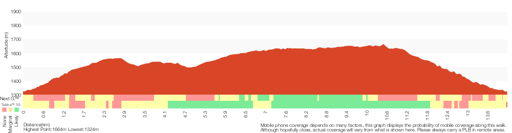
Analysis and summary of the altitude variation on the Munyang River Circuit
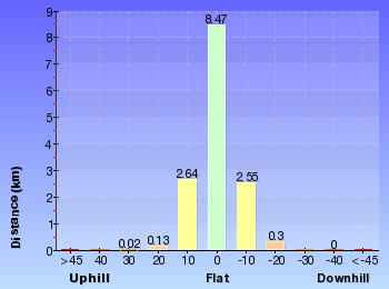
Overview of this walks grade – based on the AS 2156.1 – 2001
Under this standard, a walk is graded based on the most difficult section of the walk.
| Length | 14.1 km | ||
| Time | 5 hrs 30 mins | ||
| . | |||
| Grade 4/6 Hard track |
AS 2156.1 | Gradient | Very steep (4/6) |
| Quality of track | Clear and well formed track or trail (2/6) | ||
| Signs | Directional signs along the way (3/6) | ||
| Experience Required | Moderate level of bushwalking experience recommended (4/6) | ||
| Weather | Forecast, unforecast storms and severe weather may impact on navigation and safety (4/6) | ||
| Infrastructure | Limited facilities, not all cliffs are fenced (3/6) |
Some more details of this walks Grading
Here is a bit more details explaining grading looking at sections of the walk
Gradient
12km of this walk has short steep hills and another 1.3km is very steep. The remaining (390m) is flat with no steps.
Quality of track
This whole walk, 14km follows a clear and well formed track or trail.
Signs
Around 14km of this walk has directional signs at most intersection, whilst the remaining 390m is clearly signposted.
Experience Required
9km of this walk requires a leader a with moderate level of bushwalking experience and another 5km requires some bushwalking experience. The remaining (390m) requires no previous bushwalking experience.
weather
Around 14km of this walk is affected by forecast, unforecast storms and severe weather events that may impact on navigation and safety, whilst the remaining 390m is not usually affected by severe weather events (that would unexpectedly impact safety and navigation).
Infrastructure
Around 14km of this walk has limited facilities (such as not all cliffs fenced), whilst the remaining 390m is close to useful facilities (such as fenced cliffs and seats).
Similar walks
A list of walks that share part of the track with the Munyang River Circuit walk.
22.4 km Return
9 hrs
Hard track
Other Nearby walks
A list of walks that start near the Munyang River Circuit walk.
3.3 km Return
1 hr 30 mins
Hard track
6 km Return
3 hrs
Very experienced only
5.2 km One way
2 hrs 45 mins
Hard track
2.5 km Return
1 Hr
Moderate track
17.4 km Return
8 hrs
Experienced only
25.8 km One way
2 Days
Experienced only
15.2 km One way
6 hrs 30 mins
Experienced only
6.4 km Return
2 hrs 45 mins
Moderate track
14.8 km Return
6 hrs 45 mins
Experienced only
6.4 km Return
2 hrs 30 mins
Moderate track
45 km Circuit
4 Days
Experienced only
3 km Circuit
1 hr 30 mins
Moderate track
Plan your trip to and from the walk here
The Munyang River Circuit walk starts and ends at the Munyang car park (gps: -36.350976, 148.41342)
Your main transport option to Munyang car park is by;
![]() Car. A park entry fee is required for driving into the park.
Car. A park entry fee is required for driving into the park.
(get details)
Short URL = http://wild.tl/mrc
Gallery images
There are other downloads I am still working on.
You will probably need to login to access these — still all free.
* KML (google earth file)
* GPX (GPS file)
Special Maps/ brochures
* A3 topo maps
* PDF with Lands Topo map base
* PDF with arial image (and map overlay)
I wanted to get the main site live first, this extra stuff will come in time.
Happy walking
Matt 🙂
Merritts Traverse
And Walk
Merritts Traverse

3 hrs
5.8 km Circuit
167 m
Hard track
This walk starts with a scenic journey to the top of the hill on the chairlift. Starting along Merritts Nature walk, this walk soon detours down the hill by following a series of signposted management trails and ski runs. The walk visits a few scenic creeks, but the main highlights are the wide views of Thredbo Valley.
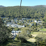
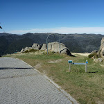

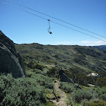

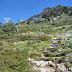


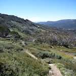

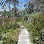

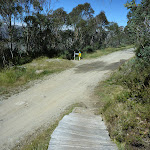
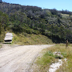

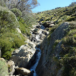

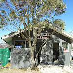
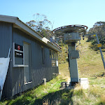
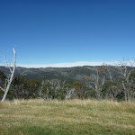


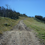

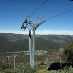


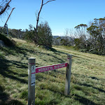
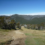

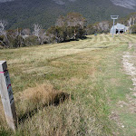
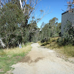


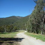
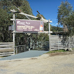

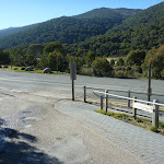
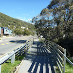


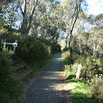
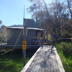
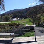

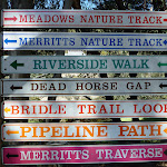
Covered in snow & closed part of the year
This walk leads through an extreme alpine environment and all walkers must be well prepared. During summer, be prepared for both very hot and cold weather, high winds, rain, snow, extreme UV levels and some sections of snow or ice on the ground. Before starting this walk, check advice with Snowy Region Visitor Information Centre (02) 6450 5600, the weather forecast and the snow conditions then change your plans as needed. These notes, grades and walking times have been written for use in the summer months only.
Part of this walk is used as a groomed winter ski run. This walk is closed and should not be attempted when there is a chance of significant snow on the ground.
Part of this walk is used as a groomed winter ski run. This walk is closed and should not be attempted when there is a chance of significant snow on the ground.
Kosciuszko Express Chairlift
This is one of the few lifts operating in the summer months at Thredbo, and is made quite popular by thousands of people walking to the summit of Mt Kosciuszko each year. Lift tickets can be purchased from the store at the bottom of the chairlift. Lift tickets are $31 return ($25 one way) per person. This lift is generally closed during November and May for maintenance each year, but the the Snowgum chair can be used at this time instead, this will add extra walking time to you walk. More info.
(0km) Bottom of Kosciuszko Express chairlift → Top of Kosciuszko Express chairlift
1.9 km
20 mins
558m
-1m
Very easy
This walk heads into the ‘Valley Terminal’ building, where you can buy a ticket for the lift. Continue through the building and up the steps, where this walk turns right to find the bottom terminal of the ‘Kosciuszko Express’. Walk up to the platform as directed by the chairlift operator and sit down in the seat, letting it scoop you up. Once seated, pull down the safety bar and enjoy the ride to the top of the ridge. 🙂
At the top step of the chair lift and turn left to find the restaurant (now on your right) and track information signs ahead.
At the top step of the chair lift and turn left to find the restaurant (now on your right) and track information signs ahead.
Eagles Nest Restaurant
This is Australia’s highest restaurant, providing great food and outstanding views. It is easily accessible, nestled on the mountain directly opposite the top of the Kosciuszko Express chairlift, and is open year-round. For more information, call (02) 64576019.
(1.86km) Top of Kosciuszko Express chairlift → Top of Snowgums chairlift
420 m
12 mins
11m
-84m
Hard track
Turn sharp left: From the top of the chairlift[3], this walk heads straight downhill (keeping the chairlift to your left) following paved management trail[4]. After about 25m, this walk veers right to leave the paved trail, now following the dirt track marked by the ‘Merritts Nature Track’ sign[5]. The track follows the arrow posts among the granite boulders[6] and down the long series of steps that leads under the chairlift[7]. The track continues to wind steeply down the hill[8] and after some time, comes to a clear ‘T’ intersection with a dirt management trail marked with another ‘Merritts Nature Track’ sign[9].
Turn left: From the intersection, this walk follows the ‘Merritts Nature Track’ sign[10] downhill along the wide management trail, keeping the main valley to your right. The trail soon leads to a four-way intersection marked with a ‘Kosciuszko Walk’ sign[11], just above the top of Snowgums chairlift[12].
Turn left: From the intersection, this walk follows the ‘Merritts Nature Track’ sign[10] downhill along the wide management trail, keeping the main valley to your right. The trail soon leads to a four-way intersection marked with a ‘Kosciuszko Walk’ sign[11], just above the top of Snowgums chairlift[12].
(2.28km) Top of Snowgums chairlift → Lower bench seat
290 m
8 mins
2m
-73m
Hard track
Turn right: From the intersection, this walk follows the track that leads down the left side of the Snowgums chairlift, where the track soon passes a ‘Merritts Nature Track’ sign[13]. The track heads left, away from the chairlift through some snow gums and winds steeply down the hill[14]. About 100m from the chairlift, the walk turns right at a minor intersection[15] (the left branch leads to a view of a small fall) – here, the main track leads down more steep steps to come to a small clearing, with a view of the creek[16] and a wooden bench seat[17].
Veer right: From the bench seat[18], this walk follows the clear track downhill, which soon heads down the steep steps[19][20], coming to another bench seat (and another good excuse for a rest).
Veer right: From the bench seat[18], this walk follows the clear track downhill, which soon heads down the steep steps[19][20], coming to another bench seat (and another good excuse for a rest).
Lower bench seat
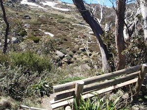
(2.57km) Lower Bench Seat → Int of Merritts nature track and Village trail (upper)
210 m
6 mins
1m
-48m
Hard track
Veer right: From the bench seat[23], this walk follows the track heading downhill away from the creek[24]. The track passes over a timber[25] then metal[26] section of boardwalk, before heading down a series of steep steps[27]. The track winds down the hill, passing some large boulders[28] before heading down a timber ramp[29] to a four-way intersection with a wide management trail.
(2.78km) Int of Merritts nature track and Village trail (upper) → Bottom of Antons
470 m
11 mins
20m
-42m
Moderate track
Turn left : From the intersection, this walk follows the ‘Merritts Traverse’ sign[30] fairly steeply downhill along the wide management trail, as it bends to the right[31]. Soon the walk comes to an intersection and turns sharply left[32] following another ‘Merritts Traverse’ sign[33]. Now fairly flat, the trail bends around the side of the hill, crossing a creek[34] and then, about 200m later, coming to Sponars T-bar lower station[35]. Continuing along the wide trail (following the arrow posts[36] for just over 200m), this walk then comes to the station at the bottom of Antons T-bar[37].
(3.25km) Bottom of Antons → Top of Gunbarrel Express
500 m
17 mins
85m
-11m
Hard track
Continue straight: From the station at the bottom of Antons T-bar[38], this walk follows the arrow post[39] along the clear management trail, steeply up the hill. After about 150m, the trail passes just below ‘Frostbite’ cafe[40][41] (only open in winter) and continues steeply up the hill[42]. Just as the trail begins to flatten out, it passes an intersection (ignoring the trail on your left) marked with a ‘Merritts Traverse’ sign[43]. Here the walk continues uphill and soon crosses a creek (with a small dam[44] on your left), coming to the large station at the top of Gunbarrel Express chairlift[45].
Top of Gunbarrel Express
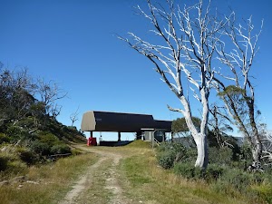
(3.75km) Top of Gunbarrel Express → Bottom of The Cruiser
840 m
19 mins
3m
-125m
Moderate track
Continue straight: From the station at the top of Gunbarrel Express[50], this walk heads east following the wide management trail, keeping the main valley to your right[51]. Soon this walk takes the right-hand fork at the ‘Y’ intersection, following the ‘Merritts Traverse’ sign[52] gently downhill. After about 300m of following the arrow posts[53] across a couple of ski runs, this walk comes to another ‘Merritts Traverse’ sign[54]. Here the walk turns right and heads down the middle of the ski run[55]. Soon the grassy trail leads to the left, following an arrow post through a grove of trees[56], and then turns right[57] and follows beside the chairlift[58] down to the station at the bottom of ‘The Cruiser’[59].
(4.59km) Bottom of The Cruiser → Schuss intersection
1.5 km
37 mins
9m
-261m
Hard track
Turn left : From the the bottom of the chairlift[60], this walk follows the ‘Merritts Traverse’ sign[61] downhill along the wide management trail, initially keeping the Cruiser station to your right[62]. The trail leads down the hill, fairy steeply in places, and after about 270m, the trail bends sharply left[63] then after a further 240m, it bends sharply right[64]. The trail leads through the snow gum forest[65] and past a few small service buildings[66][67] to pass under a chairlift[68]. Just over 200m after passing under Gunbarrel Express chairlift, the trail heads over a creek[69] then follows beside Merritts chairlift[70] to find a clear three-way intersection[71]. There is another ‘Merritts Traverse’ sign[72] pointing back up the hill.
(6.11km) Schuss intersection → Friday Flats
480 m
10 mins
0m
-55m
Moderate track
Turn left: From the intersection, this walk heads away from Merritts Chairlift[73] and the face of the ‘Merritts Traverse’ sign[74], to head downhill along the management trail[75]. This section of the walk follows the ‘Sundowner’ ski run over a (lovely mossy) creek[76] and down this hill to Friday Flats[77], a large open area at the bottom of Gunbarrel Express[78]. Just beyond the chairlift station, this walk comes to an intersection at the start of the sealed driveway, marked with a ‘Bridle Trail Loop’ and ‘Merritts Traverse’ sign[79].
Friday Flat
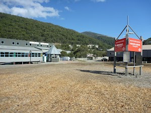
Friday Flat is an open flat area at the Bottom of the Easy-Does-it and Gunbarrel chairlifts. Friday Flat is a hub for beginner and hungry skiers in winter. In summer, all the facilities are closed, but the web cam seems to run most of the time.
(6.65km) Thredboland intersection → Int of Friday Drive and Merritts Nature Track
430 m
8 mins
7m
-10m
Very easy
Turn sharp right: From the intersection, this walk follows the footpath keeping Friday Dr to your left, heading away from the roundabout, to cross a bridge almost immediately. The walk continues along the side of the road past ‘River Inn’[84] and about 100m later passes the ‘Thredbo Leisure Centre’[85] (on the other side of the road). Just shy of 200m later this walk comes to an intersection with a set of steps signposted as ‘Merritts Nature Track’[86] (on your right), just before the Thredbo River bridge[87].
(7.08km) Int of Friday Drive and Merritts Nature Track → Int of Riverview Terrace track and Merritts Nature Track
70 m
2 mins
11m
0m
Easy track
(7.15km) Int of Riverview Terrace track and Merritts Nature Track → Bottom of bobsled run
240 m
4 mins
5m
-8m
Moderate track
Turn left: From the intersection, this walk follows the ‘Merritts Nature Walk’ sign[91] along the paved footpath, keeping the road and valley to your left. The path soon crosses a metal grate[92] and heads through a grove of trees, coming to a three-way intersection marked with an arrow post[93] (and a ‘Merritts Nature Track’ sign pointing up the steps the right[94]).
Continue straight: From the intersection, this walk follows the paved footpath west towards the clearing[95], keeping the valley to your left. The footpath soon leads out of the bush[96] and then along side the bobsled run[97] to find the building at the bottom of the run[98].
Continue straight: From the intersection, this walk follows the paved footpath west towards the clearing[95], keeping the valley to your left. The footpath soon leads out of the bush[96] and then along side the bobsled run[97] to find the building at the bottom of the run[98].
Thredbo Bobsled
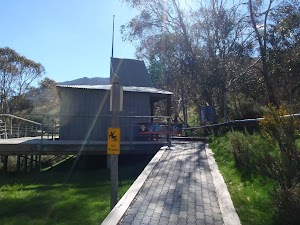
With a twisting and turning path more than 700m long, this luge-style track is a great summer activity for the family to enjoy whilst staying in Thredbo. Offering individual rides or day passes, allowing you to enjoy this fun ride as many times as you want as you whizz down the mountain on your cart, controlling your speed with a neat hand-break system. More info.
(7.39km) Bottom of bobsled run → Bottom of Kosciuszko Express chairlift
230 m
5 mins
13m
-6m
Moderate track
Continue straight: From the bottom of the bobsled run, this walk heads around the building, down the ramp[99] and along the sealed path towards the tennis courts[100]. The walk follows the path beside the tennis courts[101], then through the car park, and around the front of the buildings[102][103] to find the entrance to the ticket sales for the Kosciuszko Express chairlift, and a large map.
Maps for the Merritts Traverse walk
You can download the PDF for this walk to print a map.
These maps below cover the walk and the wider area around the walk, they are worth carrying for safety reasons.
| Perisher Valley | 1:25 000 Map Series | 85252S PERISHER VALLEY | NSW-85252S |
| Chimneys Ridge | 1:25 000 Map Series | 85241N CHIMNEYS RIDGE | NSW-85241N |
| Kosciuszko | 1:100 000 Map Series | 8525 KOSCIUSZKO | 8525 |
| Jacobs River | 1:100 000 Map Series | 8524 JACOBS RIVER | 8524 |
Cross sectional view of the Merritts Traverse bushwalking track
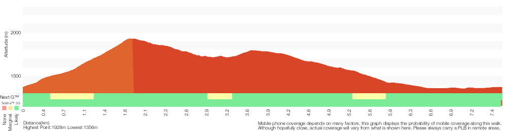
Analysis and summary of the altitude variation on the Merritts Traverse
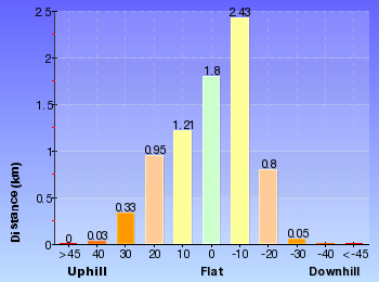
Overview of this walks grade – based on the AS 2156.1 – 2001
Under this standard, a walk is graded based on the most difficult section of the walk.
| Length | 5.8 km | ||
| Time | 3 hrs | ||
| . | |||
| Grade 4/6 Hard track |
AS 2156.1 | Gradient | Very steep (4/6) |
| Quality of track | Formed track, with some branches and other obstacles (3/6) | ||
| Signs | Directional signs along the way (3/6) | ||
| Experience Required | Some bushwalking experience recommended (3/6) | ||
| Weather | Storms may impact on navigation and safety (3/6) | ||
| Infrastructure | Generally useful facilities (such as fenced cliffs and seats) (1/6) |
Some more details of this walks Grading
Here is a bit more details explaining grading looking at sections of the walk
Gradient
2.8km of this walk is very steep and another 2.7km is flat with no steps. Whilst another 1.4km has short steep hills and the remaining 690m has gentle hills with occasional steps.
Quality of track
4.3km of this walk follows a clear and well formed track or trail and another 2.9km follows a smooth and hardened path. The remaining (430m) follows a formed track, with some branches and other obstacles.
Signs
Around 4.3km of this walk is clearly signposted, whilst the remaining 3.3km has directional signs at most intersection.
Experience Required
Around 6km of this walk requires no previous bushwalking experience, whilst the remaining 1.6km requires some bushwalking experience.
weather
Around 5km of this walk is affected by storms that may impact your navigation and safety, whilst the remaining 2.5km is not usually affected by severe weather events (that would unexpectedly impact safety and navigation).
Infrastructure
This whole walk, 8km is close to useful facilities (such as fenced cliffs and seats).
Similar walks
A list of walks that share part of the track with the Merritts Traverse walk.
2.2 km Return
1 Hr
Hard track
2.9 km Circuit
1 hr 15 mins
Moderate track
3.1 km Circuit
1 hr 30 mins
Hard track
3.3 km Circuit
1 hr 15 mins
Moderate track
3.7 km Circuit
2 hrs 30 mins
Hard track
3.8 km Return
2 hrs 30 mins
Hard track
5.3 km One way
3 hrs
Hard track
7.5 km Return
3 hrs 45 mins
Hard track
9.8 km Circuit
4 hrs 30 mins
Hard track
10.1 km Circuit
5 hrs
Hard track
12.2 km One way
5 hrs
Hard track
12.4 km Return
6 hrs
Hard track
25.8 km One way
2 Days
Experienced only
Other Nearby walks
A list of walks that start near the Merritts Traverse walk.
3.3 km Circuit
1 hr 15 mins
Moderate track
4.8 km One way
1 hr 45 mins
Moderate track
4.7 km Return
2 hrs
Moderate track
4.1 km Return
1 hr 45 mins
Moderate track
9.7 km Return
4 hrs
Hard track
19.6 km Return
7 hrs 30 mins
Hard track
778 m Return
30 mins
Moderate track
2.4 km Return
1 hr 30 mins
Hard track
4.2 km Circuit
2 hrs 15 mins
Hard track
3.8 km Return
1 hr 45 mins
Hard track
15.2 km Return
5 hrs 30 mins
Hard track
12 km Return
4 hrs 30 mins
Hard track
Plan your trip to and from the walk here
The Merritts Traverse walk starts and ends at the Bottom of Kosciuszko Express chairlift (gps: -36.503981, 148.30397)
Your main transport option to Bottom of Kosciuszko Express chairlift is by;
![]() Car. A park entry fee is required for driving into the park.
Car. A park entry fee is required for driving into the park.
(get details)
Short URL = http://wild.tl/1k
Gallery images
There are other downloads I am still working on.
You will probably need to login to access these — still all free.
* KML (google earth file)
* GPX (GPS file)
Special Maps/ brochures
* A3 topo maps
* PDF with Lands Topo map base
* PDF with arial image (and map overlay)
I wanted to get the main site live first, this extra stuff will come in time.
Happy walking
Matt 🙂
Guthega to Mt Twynam
And Walk
Guthega to Mt Twynam

6 hrs 45 mins
14.8 km Return
913 m
Experienced only
This walk starts from Guthega and makes its way along the Snowy River to the Illawong Lodge, via the Blue Cow Creek flying fox. From the lodge, the walk crosses the suspension bridge and begins the climb up the ridge past Pounds Creek Flats to the top of Mt Twynam. From here, there is an optional side trip along the ridge line to a point with better views of the lake, before returning to Guthega.* This walk passes through very remote areas and sections have no visible track. At least one person in your group should have training and experience in off track walking and navigation. Even with these notes and a GPS these extra skills and equipment are required.


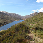
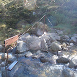
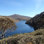


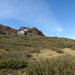
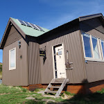

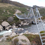
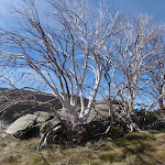
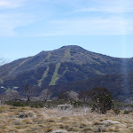
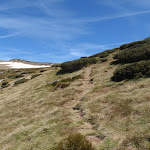
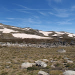
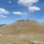
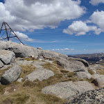
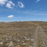
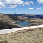
Covered in snow part of the year
This walk leads through an extreme alpine environment and all walkers must be well prepared. During summer, be prepared for both very hot and cold weather, high winds, rain, snow, extreme UV levels and some sections of snow or ice on the ground. Before starting this walk, check advice with Snowy Region Visitor Information Centre (02) 6450 5600, the weather forecast and the snow conditions then change your plans as needed. These notes, grades and walking times have been written for use in the summer months only. Between May and the end of October, this walk is likely to be covered in snow/ice, visitors should be carrying and be prepared to use snowshoes or cross country skis. When there is a chance of significant snow on the ground, visitors will need particularly strong navigation and snowcraft skills – tracks and signage may not be visible. For most visitors, it is best to consider this walk closed during the colder months.
Guthega
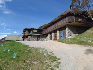
Guthega is a relatively small township, north of Perisher, and comprises mostly of hotel and lodge-style buildings. The most popular service in town is the Guthega Alpine Inn, open year round. The town is remote and access is by an all-weather dirt road. There are great views over the main range and the Guthega Pondage (part of the Snowy River Scheme). Guthega offers a great place to ski in winter, and to holiday in summer. In summer, there is plenty of walking, mountain biking, fishing and relaxing to be done. Walkers please note – there is no public water supply in the township, please fill water bottle before coming (or be willing treat and use the creek water).
Guthega Alpine Inn
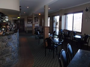
Guthega Alpine Inn is on Guthega Road, about 500 metres past the base of the chairlift and ‘Guthega Centre’. The hotel provides a year-round service including accommodation and meals. The hosts are friendly and the hotel provides a great base for walkers and other holiday makers. Please phone and book ahead for meals and accommodation. Phone 02 6457 5383
More info.
More info.
(0km) Car park below Guthega Alpine Inn → Int. of Guthega road servicetrail and Flying fox track
480 m
10 mins
6m
-34m
Moderate track
From the car park (just below Guthega Alpine Inn, on Guthega Rd, 500m past the Guthega Centre), the walk follows the concrete road down the hill, keeping the main valley to the left. The road passes a small stone building and light post, just before coming to an intersection with another road heading off to the left, below the building named ‘Toibunga’.
Turn sharp left: From the intersection, the walk follows the concrete road down the hill towards the dam. After about 100m, the track veers right at another intersection, following the lower track. The concrete track turns to the right, but this walk continues straight, onto the wide dirt management trail (between the small boulders). Soon the trail bends right and comes to an intersection with a bush track.
Turn sharp left: From the intersection, the walk follows the concrete road down the hill towards the dam. After about 100m, the track veers right at another intersection, following the lower track. The concrete track turns to the right, but this walk continues straight, onto the wide dirt management trail (between the small boulders). Soon the trail bends right and comes to an intersection with a bush track.
(0.48km) Int. of Guthega road servicetrail and Flying fox track → Flying Fox
330 m
9 mins
15m
-44m
Moderate track
Turn left: From the intersection, the walk heads between the boulders and is fairly flat initially, then, near a snow gum, the track steps down steeply and then winds down the hill to a ‘T’ intersection above Blue Cow Creek. (There is broken glass along this section of track, left over from Snowy River Scheme Camps).
Veer left: From the intersection, the walk initially steps over a small, eroded gap in the track[1] and then heads upstream alongside Blue Cow Creek, keeping the creek to your right. Before long, the track comes closer to the creek, and reaches a rocky crossing with a bridge[2] and a flying fox[3] over the creek.
Veer left: From the intersection, the walk initially steps over a small, eroded gap in the track[1] and then heads upstream alongside Blue Cow Creek, keeping the creek to your right. Before long, the track comes closer to the creek, and reaches a rocky crossing with a bridge[2] and a flying fox[3] over the creek.
Flying Fox
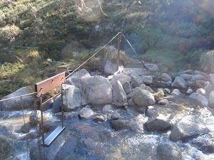
This metal flying fox was put in place to provide a safer option for crossing Blue Cow Creek when the water rises over the rocks. There are many flying foxes in the area to help people cross creeks, especially useful during snow melt when water is cold, deep and fast-moving. In 2010, a metal bridge was installed over this creek, parallel to the flying fox, and the bridge is now the safest way to cross.
(0.81km) Blue Cow Creek crossing → Illawong Lodge
2.2 km
50 mins
129m
-87m
Moderate track
Turn right: From the intersection, the walk crosses the creek on the bridge[4] next to the metal flying fox[5]. The walk then follows the bush track on the other side as it climbs to the top of the ridge. From the top of the hill, the track then winds down towards the Snowy River then turns left and generally follows it upstream. Soon the walk crosses a small creek and continues up the other side, undulating through the valley, crossing several more small creeks. The track winds left, away from the Snowy River, to climb the short hill to Illawong Lodge.
Illawong Lodge
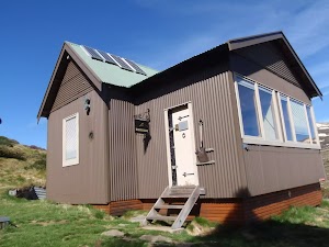
In 1956, the year after the Guthega Dam was first filled, the Kosciuszko State Park Trust gave permission for the conversion of the then-dilapidated hut into the present simple lodge. The lodge is maintained by members of Illawong Ski Tourers and friends. The nearby suspension bridge over the Snowy River and the flying fox over Farm Creek were built by members of Illawong. NPWS now maintains the suspension bridge and a new bridge over Farm Creek which has replaced the flying fox. The lodge can be reserved by members of the general public – see illawong.asn.au. There is also a small emergency shelter in the base of the hut, on the western wall, with enough room for a few people to see out a blizzard, with some water, blankets and other emergency supplies. More info.
(3.03km) Illawong Lodge → Suspension bridge
160 m
4 mins
0m
-28m
Moderate track
Turn right: From the west side of Illawong Lodge (where the emergency shelter is located), the walk heads down towards the creek following the bush track. The track winds through scrub, passing through a grass clearing along the way. The walk soon comes to a cable suspension bridge.
Suspension Bridge
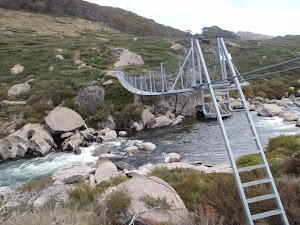
Constructed and maintained by Illawong Ski Tourers, and only a stone’s throw from Illawong Lodge, this cable suspension bridge provides a safer way to cross the upper Snowy River. This provides the main access between Guthega and the Main Range. The bridge also provides great views of the valley.
(3.19km) Suspension bridge → Pounds Creek flats
2.6 km
1 hr 13 mins
342m
0m
Experienced only
Continue straight: From the suspension bridge, this walk crosses the Snowy River to the west bank and climbs the hill, tending to the left of the top of the hill, and continuing up through the thick scrub. This section of the walk their is not track please fan out and minimse your impact. The walk winds up the ridge line through some more shallow scrub, passing through a thin tree line. The walk continues around to the left side of the ridge, where it gets much steeper, staying high out of the gully (which is to your left). The walk continues to the top of the ridge where it is much rockier, next to the large flats near the headwaters for Pounds Creek.
Pounds Creek Flats
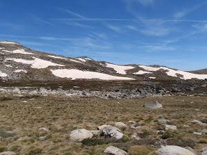
Located in the far upper reaches of Pounds Creek, this large flat area on the side of the ridge makes a great place to camp. The plateau forms a shallow hanging swamp in the few months after winter, when the snow melts and pools in the area.
This campsite is flat and sheltered from the wind by the mountain. Water supply from the creek is unreliable.
(5.78km) Pounds Creek flats → Twynam saddle
1.1 km
29 mins
131m
0m
Experienced only
Veer left: From the flats, this walk heads south-west, following the ridge line that runs up the steep hill. The walk winds up and around the left side of the flats towards Little Twynam, bending around to the right as it approaches the top, then climbing up into the saddle between Little Twynam and Mt Twynam.
(6.85km) Twynam saddle → Mt Twynam
580 m
13 mins
97m
0m
Experienced only
Turn right: From the saddle, this walk heads north up the grassy hill towards Mt Twynam, climbing up the steep hill and winding through rocky outcrops. The walk turns to the north-west and continuing up to the trig station at the top of Mt Twynam.
Mt Twynam
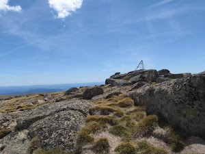
Mt Twynam is the largest peak on the ridgeline that winds around behind Blue Lake. It was once the location of a trig station, which was used for navigation until it was taken down. The metal frame, which was the lower half of the station, still sits on the peak today.
(7.42km) Mt Twynam → Blue Lake view
2 km
43 mins
25m
-108m
Experienced only
Continue straight: From the top of the mountain, this walk heads north-west, away from Little Twynam. The walk winds down through the rocky outcrops onto the ridge line, where it meets the old management trail and follows it west along the ridge line. The trail heads anticlockwise around Blue Lake until coming around to the south. The walk continues down and along the trail until coming to the right-hand side of the last knoll.
Turn left: From the intersection, the walk heads south east, towards the lake and soon reaches the top of the gentle hill. The view from here spans across the lake and down through to the gully to the northern end of Headley Tarn. At the end of this side trip, retrace your steps back to the main walk then Turn sharp left.
Turn left: From the intersection, the walk heads south east, towards the lake and soon reaches the top of the gentle hill. The view from here spans across the lake and down through to the gully to the northern end of Headley Tarn. At the end of this side trip, retrace your steps back to the main walk then Turn sharp left.
Maps for the Guthega to Mt Twynam walk
You can download the PDF for this walk to print a map.
These maps below cover the walk and the wider area around the walk, they are worth carrying for safety reasons.
| Perisher Valley | 1:25 000 Map Series | 85252S PERISHER VALLEY | NSW-85252S |
| Chimneys Ridge | 1:25 000 Map Series | 85241N CHIMNEYS RIDGE | NSW-85241N |
| Kosciuszko | 1:100 000 Map Series | 8525 KOSCIUSZKO | 8525 |
| Jacobs River | 1:100 000 Map Series | 8524 JACOBS RIVER | 8524 |
Cross sectional view of the Guthega to Mt Twynam bushwalking track
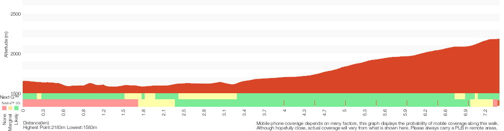
Analysis and summary of the altitude variation on the Guthega to Mt Twynam
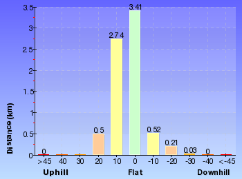
Overview of this walks grade – based on the AS 2156.1 – 2001
Under this standard, a walk is graded based on the most difficult section of the walk.
| Length | 14.8 km | ||
| Time | 6 hrs 45 mins | ||
| . | |||
| Grade 5/6 Experienced only |
AS 2156.1 | Gradient | Short steep hills (3/6) |
| Quality of track | Rough unclear track (5/6) | ||
| Signs | No directional signs (5/6) | ||
| Experience Required | High level of bushwalking experience recommended (5/6) | ||
| Weather | Forecast, unforecast storms and severe weather likely to have an impact on your navigation and safety (5/6) | ||
| Infrastructure | No facilities provided (5/6) |
Some more details of this walks Grading
Here is a bit more details explaining grading looking at sections of the walk
Gradient
7km of this walk has short steep hills and another 410m has gentle hills with occasional steps. The remaining (240m) is flat with no steps.
Quality of track
5km of this walk follows a formed track, with some branches and other obstacles and another 1.1km follows a rough unclear track. Whilst another 580m follows a rough track, where fallen trees and other obstacles are likely and the remaining 480m follows a smooth and hardened path.
Signs
3.2km of this walk has minimal directional signs and another 2.7km has directional signs at most intersection. Whilst another 1.1km Has no directional signs and the remaining 480m is clearly signposted.
Experience Required
4.2km of this walk requires a leader with a high level of bushwalking experience and another 2.7km requires some bushwalking experience. The remaining (480m) requires no previous bushwalking experience.
weather
3.2km of this walk is affected by forecast, unforecast storms and severe weather events that may impact on navigation and safety and another 2.8km is affected by storms that may impact your navigation and safety. Whilst another 1.1km forecast, unforecast storms and severe weather likely to have an impact on your navigation and safety and the remaining 400m is not usually affected by severe weather events (that would unexpectedly impact safety and navigation).
Infrastructure
2.9km of this walk has limited facilities (such as not all cliffs fenced) and another 2.9km is close to useful facilities (such as fenced cliffs and seats). Whilst another 1.1km has no facilities provided and the remaining 580m has limited facilities (such as cliffs not fenced, significant creeks not bridged).
Similar walks
A list of walks that share part of the track with the Guthega to Mt Twynam walk.
6.4 km Return
2 hrs 45 mins
Moderate track
6.4 km Return
2 hrs 30 mins
Moderate track
15.2 km One way
6 hrs 30 mins
Experienced only
17.4 km Return
8 hrs
Experienced only
25.8 km One way
2 Days
Experienced only
45 km Circuit
4 Days
Experienced only
Other Nearby walks
A list of walks that start near the Guthega to Mt Twynam walk.
3.3 km Return
1 hr 30 mins
Hard track
6 km Return
3 hrs
Very experienced only
5.2 km One way
2 hrs 45 mins
Hard track
3 km Circuit
1 hr 30 mins
Moderate track
7.3 km Circuit
3 hrs
Hard track

5.6 km Return
2 hrs 30 mins
Hard track
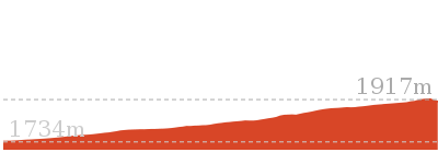
14.1 km Circuit
5 hrs 30 mins
Hard track
22.4 km Return
9 hrs
Hard track
2.5 km Return
1 Hr
Moderate track
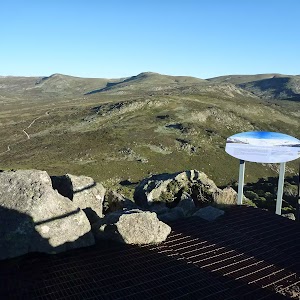
374 m Return
15 mins
Moderate track
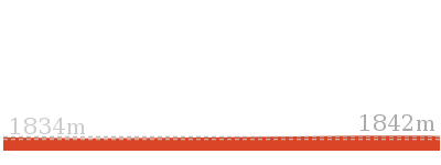
9.3 km Return
4 hrs
Hard track
1.6 km Return
45 mins
Hard track
Plan your trip to and from the walk here
The Guthega to Mt Twynam walk starts and ends at the Car park below Guthega Alpine Inn (gps: -36.382035, 148.37259)
Your main transport option to Car park below Guthega Alpine Inn is by;
![]() Car. A park entry fee is required for driving into the park.
Car. A park entry fee is required for driving into the park.
(get details)
Short URL = http://wild.tl/gtmt
Gallery images
There are other downloads I am still working on.
You will probably need to login to access these — still all free.
* KML (google earth file)
* GPX (GPS file)
Special Maps/ brochures
* A3 topo maps
* PDF with Lands Topo map base
* PDF with arial image (and map overlay)
I wanted to get the main site live first, this extra stuff will come in time.
Happy walking
Matt 🙂
Waterfall Walk
And Walk
Waterfall Walk

2 hrs 15 mins
5.8 km Circuit
205 m
Moderate track
This walk explores the upper section of Sawpit Creek from the Sawpit Creek picnic area beside Kosciuszko Road. You will follow a circuit track visiting the main highlight, a small but lovely cascade near the halfway point. The walk guides through the tall eucalypt forest, exploring the sides of the valley and passing some frost hollows and large granite boulder outcrops. An enjoyable way of exploring this pocket of Kosciuszko National Park
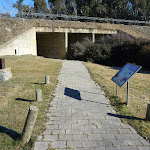


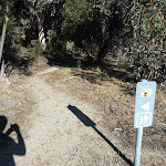


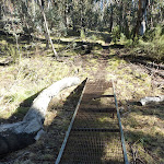


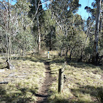
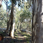
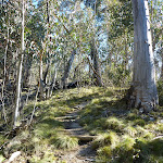

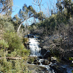
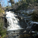


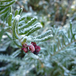
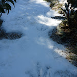
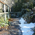


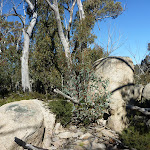


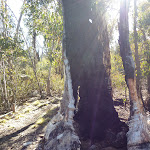
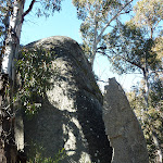
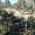
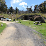
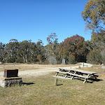
Snow & Ice on walk
This walk leads through an alpine environment and all walkers must be well prepared. During summer, be prepared for both hot and cold weather, high winds, rain, extreme UV levels and some sections of snow or ice on the ground. Before starting this walk, check advice with Snowy Region Visitor Information Centre (02) 6450 5600, the weather forecast and the snow conditions then change your plans as needed. These notes, grades and walking times have been written for use in the summer months only. Between May and the end of October, there is a much higher change of snow, ice and extremely cold conditions.
Kosciuszko Mountain Retreat
The ‘Kosciuszko Mountain Retreat’ is a caravan park about 1km further into Kosciuszko NP from the paystation on Kosciuszko Rd. The retreat provides cabins and chalets as well as powered and un-powered camping sites. The retreat has a public phone[1], a small kiosk[2], drying room[3], laundry and kids playground. Dave and Gina welcome guests all year round, with many guest skiing in winter and walking in the warmer months. More info.
Sawpit Creek Picnic Area
Sawpit Creek Picnic Area is found beside Kosciuszko Rd, and is accessed through the ‘Kosciuszko Mountain Retreat’ driveway[4]. The picnic area is about 1km further into the park from the NPWS pay station. A great starting point for several popular walks, this is also a pleasent spot to just stop and rest. Sawpit Creek[5] runs along the side of the open area and there are also several picnic tables[6], wood BBQs[7] and a non-flush toilet[8]. There are information signs about the area, explaining that the creek is named for the Alpine Ash that were milled in the area during the 1860s [9].
(0km) Waterfall trackhead → Tunnel intersection
60 m
1 mins
1m
0m
Easy track
From the ‘Waterfall Track’ sign[10] (on the western side of Sawpit Creek Picnic Area), this walk follows the paved footpath upstream through the underpass[11], under Kosciuszko Rd. The underpass may become impassable after rain, in which case you can walk around and cross over the road. The walk passes through the tunnel[12], then leads across the clearing[13] a short distance to find an intersection marked with a National Parks arrow[14] (and a footbridge a short distance to your right).
(0.06km) Tunnel intersection → Waterfall Lookout
2.5 km
48 mins
103m
-24m
Moderate track
Continue straight: From the intersection, this walk heads along the track into the bush following the National Parks sign[15], directly away from the road[16]. The track leads up along the side of the hill, keeping Sawpit Creek a short distance to your right. After walking through the wooded forest[17] for about 400m, the track crosses a small gully on a metal grate[18], then about 300m later crosses a wider open area[19] on a longer metal path[20]. The track then leads through the forest for about 500m, passing another clearing before crossing an old management trail marked with a series of white and blue posts[21] (marking a buried water main). About 300m further along, the track passes the same series of white and blue posts[22] again, before climbing up a short but moderately steep climb[23] and wandering along the side of the steep valley[24] among the tall alpine ash[25] (Eucalyptus delegatensis). The track then leads up a some timber steps[27] (with a revegetating trail crossing the track[28]) and, about 150m later, comes to the top of some metal steps[29] and the lookout at the waterfall[30].
Waterfall Lookout
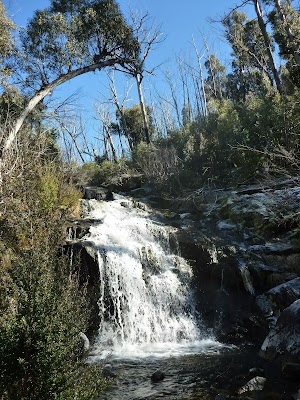
This waterfall on upper Sawpit Creek is not formally named, but is the focal point of the waterfall track that passes just in front of the falls. The water cascades down these fairly wide falls to a shallow pool below[31]. The main fall is about 4m high but the overall cascades are taller. NPWS have installed a metal bridge[32] for crossing the creek, and a small platform[33] on the south side that provides the best view of the falls.
(2.52km) Waterfall Lookout → Granite Outcrop
1.6 km
36 mins
97m
-55m
Moderate track
Turn right: From the waterfall lookout[34], this walk heads down the metal stairs[35] and crosses the creek just below the waterfall. This walk then follows the metal path and steps[36] to the right as they lead up and out of the valley. The metal path soon stops and the dirt track leads along the side of the hill before climbing a last set of metal steps[37]. The track continues to lead further away from the main valley through the eucalypt forest and about 300m after crossing Sawpit Creek, this track leads past a ‘3K’ timber milestone[38]. The track then heads down to cross a gully[39], then about 200m later crosses another gully with a metal erosion control grate[40]. From here, the track meanders through the forest for about 800m to come to a large granite outcrop[41] (mostly on your right). Here the walk continues down for another 150m through a series of granite boulders[42] to another even larger and clearer granite outcrop[43] (on your right). There is a clear view down over Lake Jindabyne[44] from the top of these boulders – much care is needed if climbing them.
Granite Outcrop
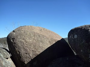
This granite outcrop is perched on the northern side of Sawpit Creek. The track passes by the rocks[45], but in favourable weather and with great care, walkers can climb up on some of these rocks[46] to enjoy the view down the valley. The view extends down Sawpit Creek valley to Lake Jindabyne and parts of the Jindabyne township.
(4.1km) Granite Outcrop → Waterfall trackhead
1.7 km
32 mins
4m
-125m
Moderate track
Continue straight: From the granite outcrop[47], this walk follows the track gently downhill, keeping the main valley to your right. The track leads past a few more granite boulders then, after about 700m, passes a ‘1K’ timber milestone[48]. About 500m further downhill, the track turns right at an interesting burnt tree[49] before passing between two large split granite boulders[50]. The track continues to lead through the wooded forest towards the sound of the road and, about 500m after passing between the split rocks, the track leads down some stone steps[51] and across a metal bridge[52] spanning Sawpit Creek. Just after crossing the creek, the walk comes to an intersection on the edge of a large clearing, next to the Kosciuszko Rd embankment[53].
Turn left: From the intersection, this walk heads across the clearing[54] then through the underpass[55], under Kosciuszko Rd. The underpass may become impassable after rain, in which case you can walk around and cross over the road. The walk continues a short distance along the paved path[56] on the other side of the tunnel to the ‘Waterfall Track’ sign[57] (on the western side of Sawpit Creek Picnic Area).
Turn left: From the intersection, this walk heads across the clearing[54] then through the underpass[55], under Kosciuszko Rd. The underpass may become impassable after rain, in which case you can walk around and cross over the road. The walk continues a short distance along the paved path[56] on the other side of the tunnel to the ‘Waterfall Track’ sign[57] (on the western side of Sawpit Creek Picnic Area).
Maps for the Waterfall Walk walk
You can download the PDF for this walk to print a map.
These maps below cover the walk and the wider area around the walk, they are worth carrying for safety reasons.
| Kalkite Mountain | 1:25 000 Map Series | 86253N KALKITE MOUNTAIN | NSW-86253N |
| Tombong | 1:50 000 Map Series | 8624S TOMBONG | NSW-8624S |
| Numbla Vale | 1:50 000 Map Series | 8624N NUMBLA VALE | NSW-8624N |
| Berridale | 1:100 000 Map Series | 8625 BERRIDALE | 8625 |
Cross sectional view of the Waterfall Walk bushwalking track
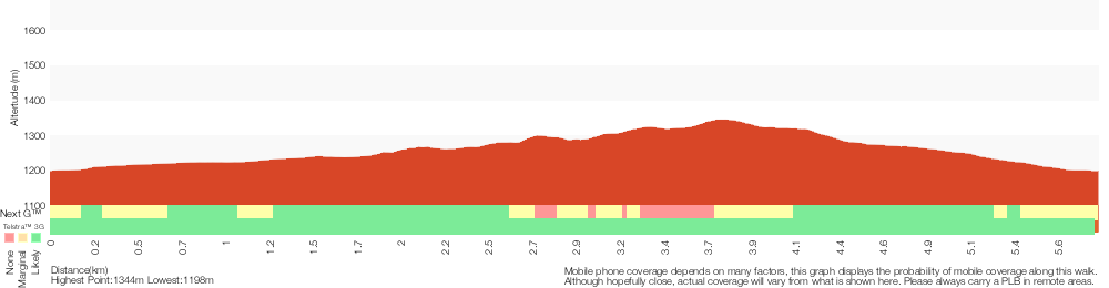
Analysis and summary of the altitude variation on the Waterfall Walk

Overview of this walks grade – based on the AS 2156.1 – 2001
Under this standard, a walk is graded based on the most difficult section of the walk.
| Length | 5.8 km | ||
| Time | 2 hrs 15 mins | ||
| . | |||
| Grade 3/6 Moderate track |
AS 2156.1 | Gradient | Short steep hills (3/6) |
| Quality of track | Formed track, with some branches and other obstacles (3/6) | ||
| Signs | Directional signs along the way (3/6) | ||
| Experience Required | No experience required (1/6) | ||
| Weather | Storms may impact on navigation and safety (3/6) | ||
| Infrastructure | Limited facilities, not all cliffs are fenced (3/6) |
Some more details of this walks Grading
Here is a bit more details explaining grading looking at sections of the walk
Gradient
3.2km of this walk has gentle hills with occasional steps and another 2.5km has short steep hills. The remaining (110m) is flat with no steps.
Quality of track
Around 6km of this walk follows a formed track, with some branches and other obstacles, whilst the remaining 110m follows a smooth and hardened path.
Signs
Around 6km of this walk has directional signs at most intersection, whilst the remaining 110m is clearly signposted.
Experience Required
This whole walk, 6km requires no previous bushwalking experience.
weather
Around 6km of this walk is affected by storms that may impact your navigation and safety, whilst the remaining 110m is not usually affected by severe weather events (that would unexpectedly impact safety and navigation).
Infrastructure
Around 6km of this walk has limited facilities (such as not all cliffs fenced), whilst the remaining 110m is close to useful facilities (such as fenced cliffs and seats).
Similar walks
A list of walks that share part of the track with the Waterfall Walk walk.
Other Nearby walks
A list of walks that start near the Waterfall Walk walk.
5.5 km One way
2 hrs 30 mins
Hard track
2.2 km Circuit
45 mins
Moderate track
12.8 km Return
5 hrs
Hard track
2.5 km Return
1 Hr
Moderate track
14.1 km Circuit
5 hrs 30 mins
Hard track
22.4 km Return
9 hrs
Hard track
5.2 km One way
2 hrs 45 mins
Hard track
3.3 km Return
1 hr 30 mins
Hard track
6 km Return
3 hrs
Very experienced only
17.4 km Return
8 hrs
Experienced only
25.8 km One way
2 Days
Experienced only
15.2 km One way
6 hrs 30 mins
Experienced only
Plan your trip to and from the walk here
The Waterfall Walk walk starts and ends at the Waterfall trackhead (gps: -36.349971, 148.56374)
Your main transport option to Waterfall trackhead is by;
![]() Car. A park entry fee is required for driving into the park.
Car. A park entry fee is required for driving into the park.
(get details)
Short URL = http://wild.tl/1l
Gallery images
There are other downloads I am still working on.
You will probably need to login to access these — still all free.
* KML (google earth file)
* GPX (GPS file)
Special Maps/ brochures
* A3 topo maps
* PDF with Lands Topo map base
* PDF with arial image (and map overlay)
I wanted to get the main site live first, this extra stuff will come in time.
Happy walking
Matt 🙂
Comments