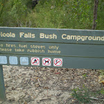
Uloola Falls camping ground

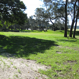
A maximum of 18 people can camp here. There is usually water available from the creek but it should be treated first before drinking. The campsite is well used, located in a small clearing near Uloola Falls. There is an opportunity to get wet in the creek and falls (swimming is limited to small water holes).


| Getting there |
|
Walk to the site along the Uloola Track, a bit south of the falls. The site is not far from the end of the management trail. |
| General Information |
|---|
| Bookings and contact information |
Phone:(02) 9542 0683 |
| Facilities | |
|---|---|
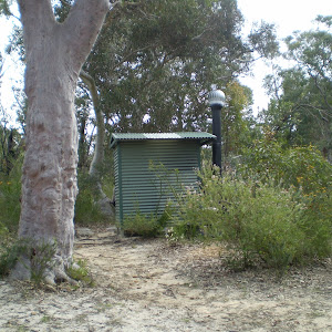
Pit or composting toilets are available |
No showers are provided on site |
No drinking water onsite – bring your own water |
No Picnic tables or shelters are provided on site |
Wood fired BBQ’s are not provided |
Gas or electric BBQ’s are not provided |
No rubbish bins provided – take your own rubbish with you |
This is a Fuel Stove only area, solid fuel (eg wood) fires are not permitted at any time. Gas stoves may be used, but be aware of local fire bans |
There are places to swim
Walk to the site along the Uloola Track, a bit south of the falls. The site is not far from the end of the management trail. http://wild.tl/3k
Park Information & Alerts
There are alerts raised for Royal National Park as at Thu, 05 Jun 2025 10:54:20 +1000Closed areas: Trails closed for upgrades – Temptation Creek/Loftus Loop Area
Some singletrack walking and mountain bike trails within the Loftus Loop network in the Temptation Creek Precinct of Royal National Park are closed from Tuesday 11 March to Monday 30 June 2025 for upgrade works. The closed areas are:
- Farnell Avenue trail
- Rawson Parade trail
- Savilles Creek trail
Penalties apply for non-compliance. For more information, contact the Royal National Parks Visitors Centre on 02 9542 0648.
Closed areas: Helicopter Operation Savilles Creek Track
NPWS will be undertaking a helicopter lifting operation to assist in the delivery of materials to repair the Savilles creek track.
Tracks and Trails in the Savilles Creek Area will be closed or have temporary access restrictions between 8am and 4pm on Thursday 5 June 25.
For more information, please contact the Royal National Park Visitor Center on 02 9542 0648
Closed areas: Deer Pool Walking Track CLOSED For Upgrade
This section of Marley walking track between the carpark and fire trail is closed for repairs until 30 June 2025.
Big Marley and Little Marley fire trails remain open. For more information, contact the Royal National Park Visitor Centre on 02 9542 0648.
Other planned events: 1080 pest management
NSW National Parks and Wildlife Service will be conducting an aerial baiting program using dried meat baits containing 1080 poison (sodium fluroacetate) for the control of foxes. The program will occur from Tuesday 6 May to Saturday 10 May 2025 in Royal National Park.
All baiting locations are identifiable by signs. Please don’t touch baits.
Domestic pets are not permitted in NSW national parks and reserves. Pets and working dogs may be affected (1080 is lethal to cats and dogs). Pets and working dogs must be restrained or muzzled in the vicinity and must not enter the baiting location. In the event of accidental poisoning seek immediate veterinary assistance.
Fox baiting in this reserve is aimed at improving the eco-health of the reserve by reducing predation of ground dwelling mammals and small birds, and specifically targeting fox control along the Hacking River to assist the successful re-introduction of platypus into Royal National Park.
Penalties apply for non-compliance. For more information, contact the NPWS Audley office on 02 9542 0632 (business hours) or the NPWS after hours call centre on 1300 056 294.
Closed areas: Werrong Beach track
Werrong Beach track in Royal National Park is closed until further notice due to landslides. Signs will be in place around the closed area.
Penalties apply for non-compliance. For more information, contact the local NPWS office.
Closed areas: The Coast track – partial closure
Walking the full length of The Coast track from Otford to Bundeena or Bundeena to Otford is not currently possible due to several track closures along its length. These closures are necessary due to erosion, rockfall risk and ongoing track upgrade works.
Please note the following closures:
- The Garie to Little Garie section of The Coast track is closed due to hazardous rockfalls and erosion
- North Era campground is closed until further notice
- Garie Road, Garie Beach and the Garie precinct is closed until further notice due to damage and subsidence of the road surface. Walkers approaching from the north (e.g. from Wattamolla or Bundeena) should exit the track via Curra Moors track.
- South bound access – Bundeena to Curra Moors track via Wattamolla and return only. There’s no access to Garie Beach.
- North bound access – Is via Garawarra Farm Ridge trail and Burgh Ridge track to North Era and return, during track upgrades.
Closed areas: North Era campground closed
North Era campground is closed until further notice due to operational activities. For more information please contact the local area office on 02 9542 0648.
Closed areas: Garie Road closed due to damage
Garie Road is closed until further notice due to damage to the road surface.
This road may remain closed for some time to allow for extensive repairs. A reopening date is not currently known.
Penalties apply for non-compliance. Please check Live Traffic NSW for updates before driving to Garie Beach.
Here are all the campsites in this park.

Near Sydney
Royal National Park
Near Sydney
Royal National Park