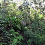
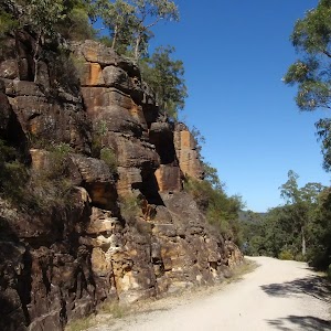
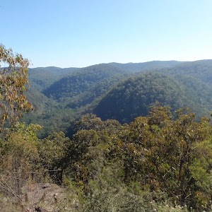
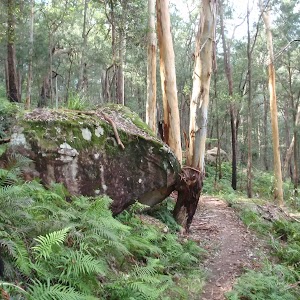
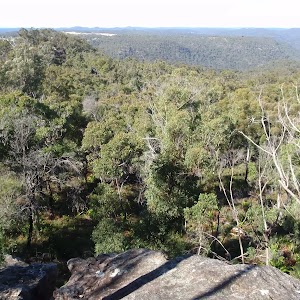
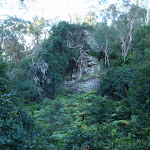
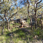
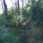
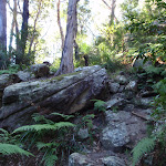
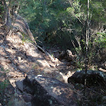
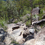
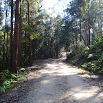
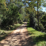
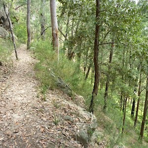
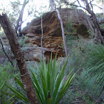
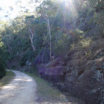
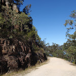
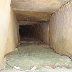
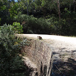
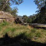
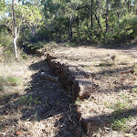
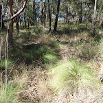
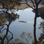
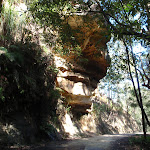
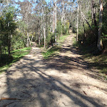
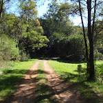
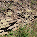
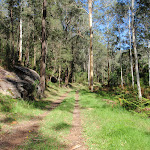
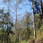
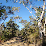
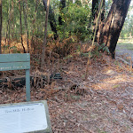
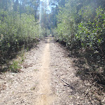
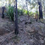
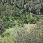
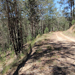
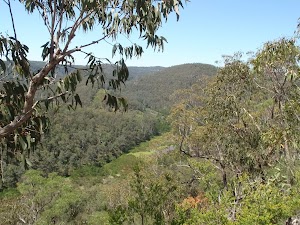
The long, gentle climb along Shepherd’s Gully has some beautiful scenery and some historic remnants of the Old Great North Road. While the remnants of the road construction are not as impressive as those on the main Devines Hill ascent, they are still interesting. The optional side trip to Hangmans Rock takes you past an old convict stockade site and some of the construction remnants on the main Devines Hill ascent.
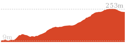
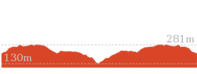
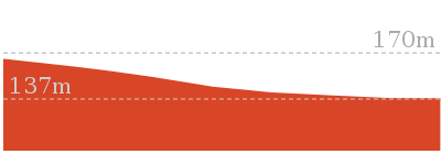
Shepherds Gully
And Walk
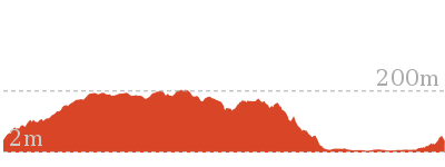
Shepherds Gully


2 hrs
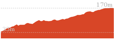
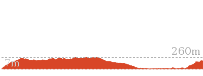
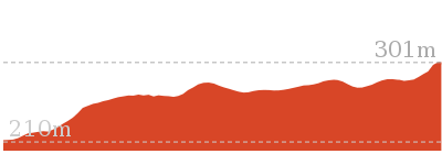
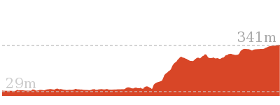
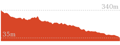
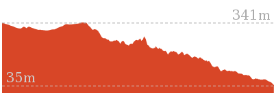
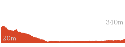
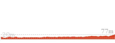
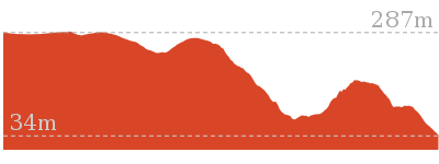
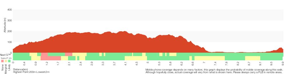
4.3 km Return

244 m
Moderate track


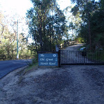
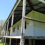
Wisemans Ferry
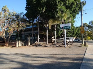
Wisemans Ferry village is on the banks of the Hawkesbury river, NSW. The town, and nearby car ferry, is named after Solomon Wiseman, a former convict who received a land grant in the area and established the ferry service. The town is a popular day trip and weekend destination from Sydney. There are several good spots to eat in town, including bistros at the Wisemans Ferry Inn and the Wisemans Ferry Bowling club, and takeaway food from Bush Bites cafe. The Riverbend Restaurant can be found in the ‘Retreat at Wisemans’ for finer dining. The area has some great walking and interesting history surrounding the convict built Old Great North Road. More info.
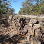
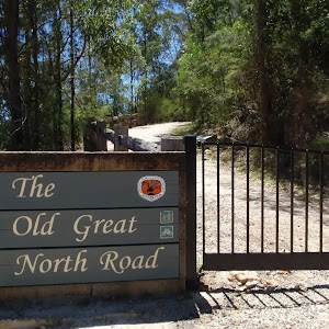
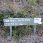
Old Great North Road

The historic Great North Road was built using convict labour between 1826 and 1836 (this section south of Wollombi was completed in 1832). The road formed a link between Sydney and the Hunter Valley, including Newcastle. There are visible remnants of the original work in bridges, retaining walls and other structures along the way. The ‘Convict Trail Project’ has member groups involved in the conservation of historical remnants along the road. The Convict Trail Project and the NPWS have erected information signs at various points to illustrate the history. The Convict Trail Project has an excellent website for further reading. More info.
(0km) Int of Settlers Rd and Shepherds Gully Rd → Int of OGNR and Shepherds Gully Rd

2.1 km
47 mins
196m
-48m
Moderate track
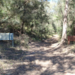
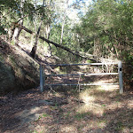
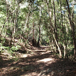
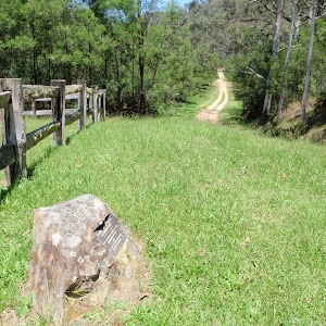
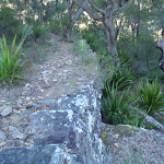
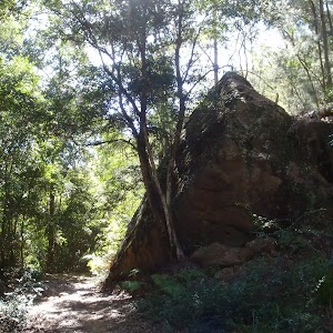
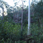
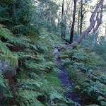
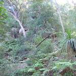
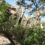
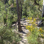
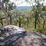
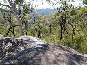
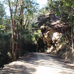
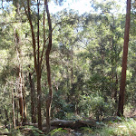
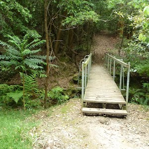
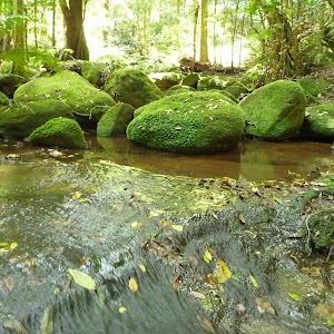
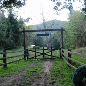
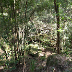
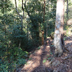
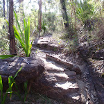
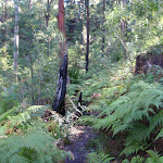
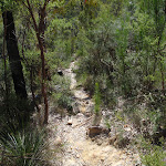
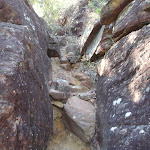
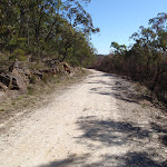
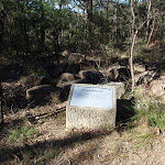
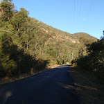
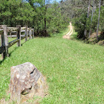
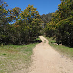
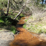
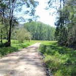
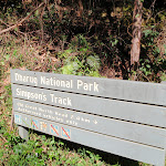
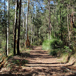
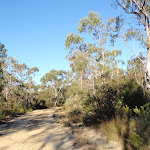
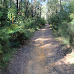
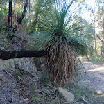
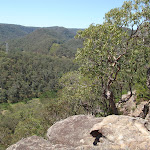
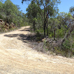
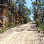
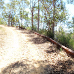
From the signposted track head on Settlers Rd, marked with a “Shepherd’s Gully Road” Convict Trail signpost (about 9km from Wisemans Ferry crossing), the walk passes the ‘Yengo National Park’ signpost and follows the management trail gently up the hill. After a short distance the walk passes an information sign and goes around a gate. The walk then continues to wind up along the valley for a long while, initially through very moist forest but getting drier as it climbs. Keep an eye out on the other side of the gully for remnants of the rock retaining walls of the earlier lines of the road. There are also some areas of beautiful scenery with lots of boulders, ferns and grasstrees. The walk eventually arrives at a signposted intersection beside a gate.
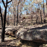
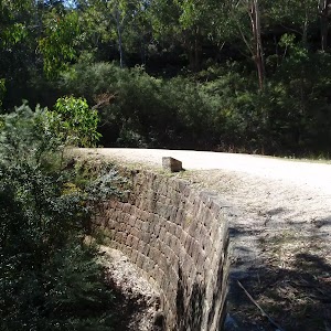
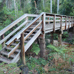
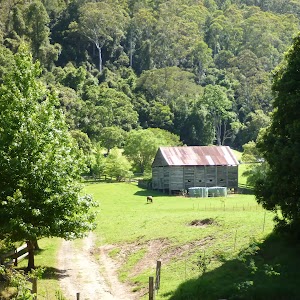
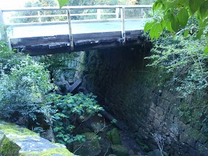
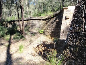
Devines Hill
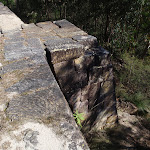
Devines Hill is a historically significant area on the Old Great North Road, near present day Wisemans Ferry, NSW. There are substantial remnants visible here, including cuttings, retaining walls and quarry sites. There were 3 main road lines built at different times to climb the hills just north of Wisemans Ferry, starting with Finchs Line to the east, followed by the Devines Hill ascent and then Shepherds Gully, to the west. Information signs in the area provide some interesting historical background and the ‘Convict Trail Project’ has an excellent website for further reading. More info.
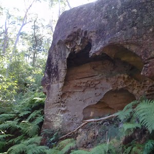
(2.15km) Int of OGNR and Shepherds Gully Rd → Hangmans Rock
720 m
18 mins
12m
-69m
Moderate track
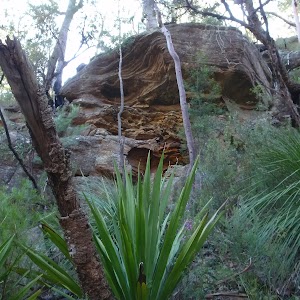
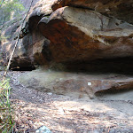
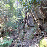
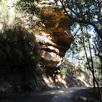
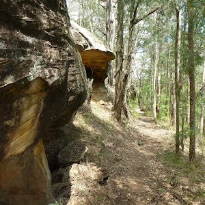
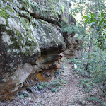
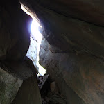
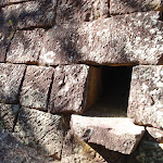
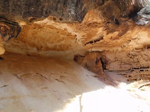
Veer right: From the intersection, the walk passes around a gate and follows the management trail gently down the hill. This section of the walk zigzags a little, passing an information sign indicating the probable site of a stockade to hold the “more troublesome convicts”, and continuing further to reach “Hangman’s Rock”. At the end of this side trip, retrace your steps back to the main walk then Veer right.
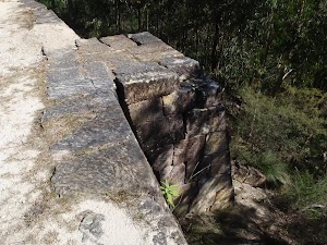
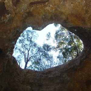
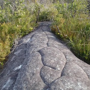
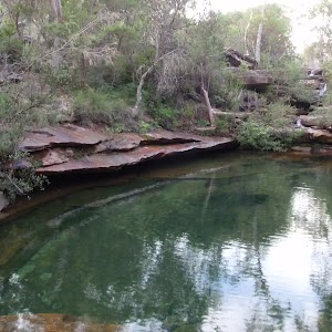
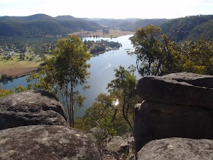
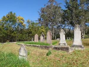
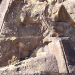
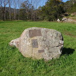
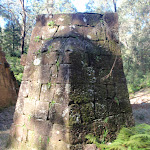
Hangmans Rock
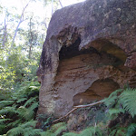
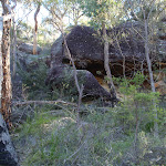
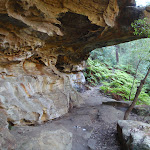
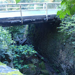
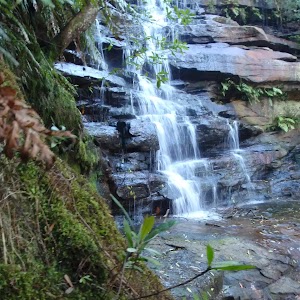
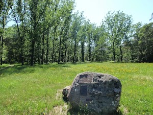
Hangmans Rock is beside the historic Old Great North Road, near Wisemans Ferry, NSW. This beautiful sandstone cave/overhang has some steps and a bench seat cut into it and is part of the history of the convict built OGNR. It is uncertain what purpose the spot served, but stories that convicts were hanged through the hole in the roof of the cave appear unlikely to be true, despite giving a name to the atmospheric spot. More info.
Maps for the Shepherds Gully walk
You can download the PDF for this walk to print a map.
These maps below cover the walk and the wider area around the walk, they are worth carrying for safety reasons.
| Lower Portland | 1:25 000 Map Series | 90312S LOWER PORTLAND | NSW-90312S |
| St Albans | 1:25 000 Map Series | 90312N ST ALBANS | NSW-90312N |
| St Albans | 1:100 000 Map Series | 9031 ST ALBANS | 9031 |
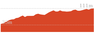
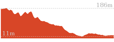
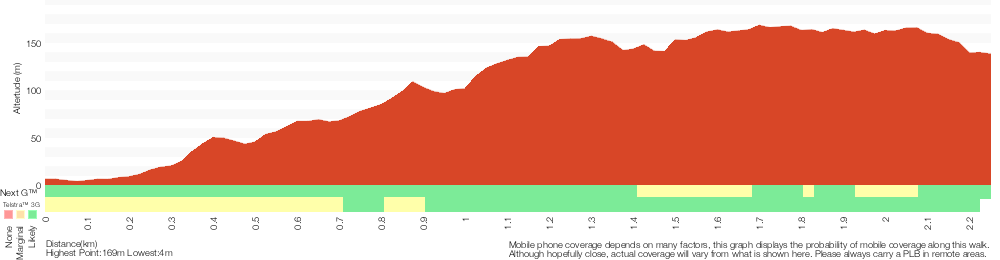
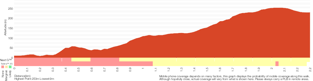
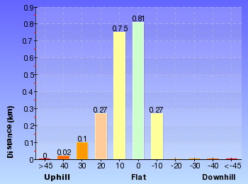
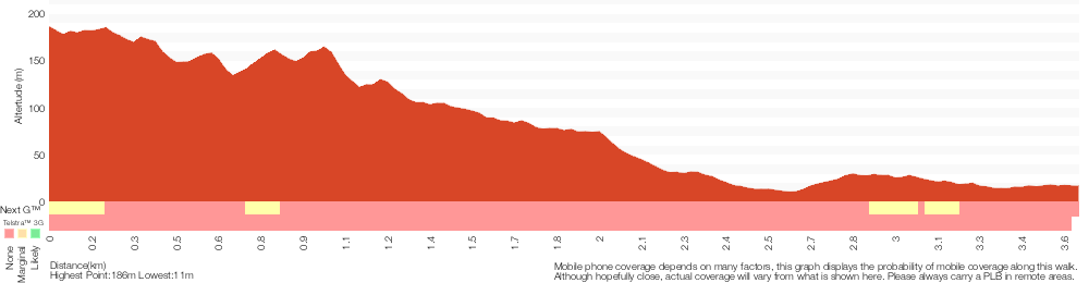
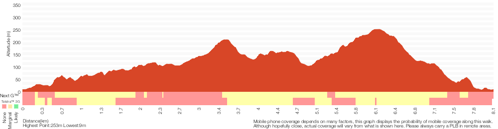
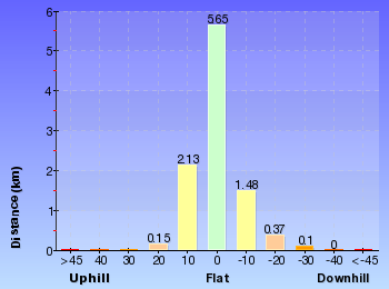
Cross sectional view of the Shepherds Gully bushwalking track
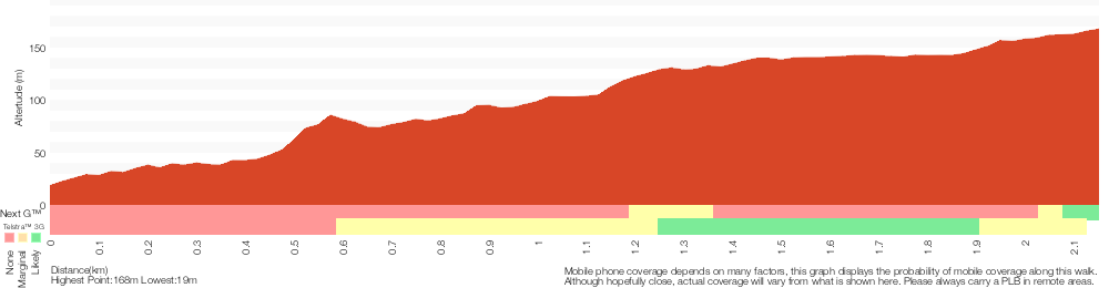
Analysis and summary of the altitude variation on the Shepherds Gully
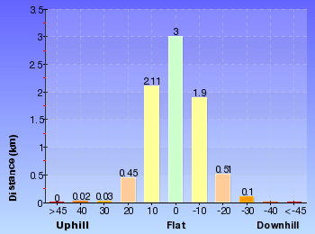
Overview of this walks grade – based on the AS 2156.1 – 2001
Under this standard, a walk is graded based on the most difficult section of the walk.
| Length | 4.3 km | ||
| Time | 2 hrs | ||
| . | |||
| Grade 3/6 Moderate track |
AS 2156.1 | Gradient | Short steep hills (3/6) |
| Quality of track | Formed track, with some branches and other obstacles (3/6) | ||
| Signs | Clearly signposted (1/6) | ||
| Experience Required | No experience required (1/6) | ||
| Weather | Weather generally has little impact on safety (1/6) | ||
| Infrastructure | Limited facilities, not all cliffs are fenced (3/6) |
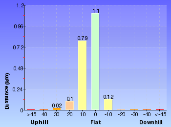
Some more details of this walks Grading
Here is a bit more details explaining grading looking at sections of the walk
Gradient
This whole walk, 2.1km has short steep hills.
Quality of track
This whole walk, 2.1km follows a formed track, with some branches and other obstacles.
Signs
This whole walk, 2.1km is clearly signposted.
Experience Required
This whole walk, 2.1km requires no previous bushwalking experience.
weather
This whole walk, 2.1km is not usually affected by severe weather events (that would unexpectedly impact safety and navigation).
Infrastructure
This whole walk, 2.1km has limited facilities (such as not all cliffs fenced).
Similar walks
A list of walks that share part of the track with the Shepherds Gully walk.
3.6 km Return
2 hrs
Moderate track
4 km One way
2 hrs
Moderate track
9.9 km Circuit
4 hrs 30 mins
Moderate track
27.3 km One way
2 Days
Hard track
Other Nearby walks
A list of walks that start near the Shepherds Gully walk.
2.2 km Return
1 hr 15 mins
Moderate track
4.4 km Return
2 hrs 15 mins
Moderate track
28.3 km One way
2 Days
Moderate track
8.2 km Circuit
4 hrs 15 mins
Hard track
4.5 km Return
2 hrs 15 mins
Hard track

1.7 km Circuit
1 Hr
Moderate track
8.3 km Return
3 hrs 15 mins
Moderate track
10.8 km Circuit
4 hrs 15 mins
Hard track
10.1 km Return
4 hrs 15 mins
Hard track
4.4 km Return
2 hrs
Hard track
24.3 km Circuit
2 Days
Hard track
7.2 km Return
3 hrs 15 mins
Moderate track
Plan your trip to and from the walk here
The Shepherds Gully walk starts and ends at the Int of Settlers Rd and Shepherds Gully Rd (gps: -33.355691, 150.98268)
Your transport options to Int of Settlers Rd and Shepherds Gully Rd are by;
![]() Bus. Wisemans Ferry Dialacar provides a taxi style mini-bus service based in Wisemans Ferry. The cost is typically about per km (ex Wisemans Ferry). They will pick-up and drop-off from Sydney or the Central Coast and will happily drop walkers off or pick them up from tracks in the area. The cost for a pick-up from Gosford and drop off near Wisemans Ferry would be approximately 0 (please call for up-to-date pricing) and the minivan can carry up to 13 passengers. Phone: 0448 122 374 (get details)
Bus. Wisemans Ferry Dialacar provides a taxi style mini-bus service based in Wisemans Ferry. The cost is typically about per km (ex Wisemans Ferry). They will pick-up and drop-off from Sydney or the Central Coast and will happily drop walkers off or pick them up from tracks in the area. The cost for a pick-up from Gosford and drop off near Wisemans Ferry would be approximately 0 (please call for up-to-date pricing) and the minivan can carry up to 13 passengers. Phone: 0448 122 374 (get details)
![]() Car. There is free parking available.
Car. There is free parking available.
(get details)


Short URL = http://wild.tl/sg
Gallery images
There are other downloads I am still working on.
You will probably need to login to access these — still all free.
* KML (google earth file)
* GPX (GPS file)
Special Maps/ brochures
* A3 topo maps
* PDF with Lands Topo map base
* PDF with arial image (and map overlay)
I wanted to get the main site live first, this extra stuff will come in time.
Happy walking
Matt 🙂
Finchs Line viewpoint
And Walk
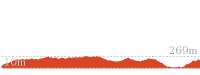
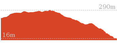
Finchs Line viewpoint

2 hrs 15 mins
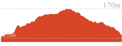
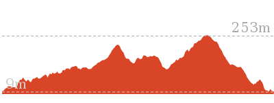
4.4 km Return
373 m
Moderate track
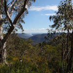
This pleasant walk follows part of the historic Finchs Line road, the original route for the Great North Road up the hills just north of Wisemans Ferry. The walk starts in moist, fern covered scenery and climbs to drier forest and some stunning views over the Hawkesbury river and Wisemans Ferry area from the unfenced Finchs Line viewpoint. There are other great views along the way too.


Old Great North Road
The historic Great North Road was built using convict labour between 1826 and 1836 (this section south of Wollombi was completed in 1832). The road formed a link between Sydney and the Hunter Valley, including Newcastle. There are visible remnants of the original work in bridges, retaining walls and other structures along the way. The ‘Convict Trail Project’ has member groups involved in the conservation of historical remnants along the road. The Convict Trail Project and the NPWS have erected information signs at various points to illustrate the history. The Convict Trail Project has an excellent website for further reading. More info.
Wisemans Ferry
Wisemans Ferry village is on the banks of the Hawkesbury river, NSW. The town, and nearby car ferry, is named after Solomon Wiseman, a former convict who received a land grant in the area and established the ferry service. The town is a popular day trip and weekend destination from Sydney. There are several good spots to eat in town, including bistros at the Wisemans Ferry Inn and the Wisemans Ferry Bowling club, and takeaway food from Bush Bites cafe. The Riverbend Restaurant can be found in the ‘Retreat at Wisemans’ for finer dining. The area has some great walking and interesting history surrounding the convict built Old Great North Road. More info.
(0km) Int of Finchs Line and Wisemans Ferry Rd → Walk Bikes Signpost
1.2 km
32 mins
189m
-42m
Moderate track
From the signposted track head, marked as ‘Finchs Line Walking Track’, beside Wisemans Ferry Rd (about 1.8 km east of the car ferry), the walk follows the bush track, going up the hill. There is an information sign after a short distance and the track starts to climb, increasingly steeply, as it zigzags up a steep hill, along the path of Finchs Line Road. There are some beautiful views away from the track and a lot of ferns, grasstrees and vines surrounding the track. After winding up the hill for quite a while the walk arrives at an intersection with a management trail, marked with a sign indicating bikes must be walked (when going back down the hill).
(1.23km) Walk Bikes Signpost → Finchs Line Sth viewpoint
970 m
25 mins
63m
-79m
Moderate track
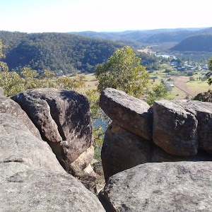
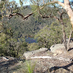
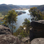
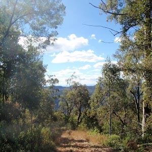
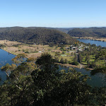
Turn right: From the signpost, the walk follows the management trail steeply up the hill. After a while, the trail levels out and offers some fantastic views across the valleys on the northern side of the ridge. The trail then switches back to the Hawkesbury side of the ridge arrives at a beautiful rock outcrop with stunning views down across the Hawekesbury and Wisemans Ferry township.
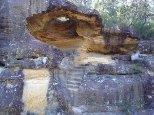
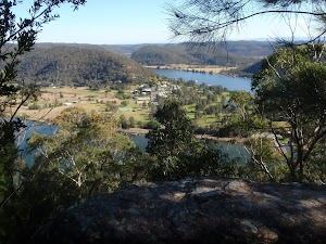
Finchs Line viewpoint
This informal, unfenced (and unnamed) lookout is on the trail along the historic Finchs Line Rd near Wisemans Ferry, NSW. The viewpoint sits on a beautiful outcrop of boulders and provides stunning views down across the Hawkesbury river and Wisemans Ferry township.
Maps for the Finchs Line viewpoint walk
You can download the PDF for this walk to print a map.
These maps below cover the walk and the wider area around the walk, they are worth carrying for safety reasons.
| Gunderman | 1:25 000 Map Series | 91313S GUNDERMAN | NSW-91313S |
| Lower Portland | 1:25 000 Map Series | 90312S LOWER PORTLAND | NSW-90312S |
| Gosford | 1:100 000 Map Series | 9131 GOSFORD | 9131 |
| St Albans | 1:100 000 Map Series | 9031 ST ALBANS | 9031 |
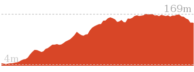
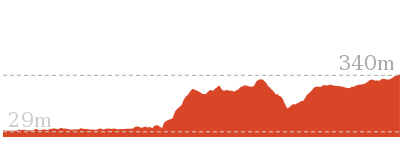
Cross sectional view of the Finchs Line viewpoint bushwalking track
Analysis and summary of the altitude variation on the Finchs Line viewpoint
Overview of this walks grade – based on the AS 2156.1 – 2001
Under this standard, a walk is graded based on the most difficult section of the walk.
| Length | 4.4 km | ||
| Time | 2 hrs 15 mins | ||
| . | |||
| Grade 3/6 Moderate track |
AS 2156.1 | Gradient | Short steep hills (3/6) |
| Quality of track | Formed track, with some branches and other obstacles (3/6) | ||
| Signs | Directional signs along the way (3/6) | ||
| Experience Required | Some bushwalking experience recommended (3/6) | ||
| Weather | Weather generally has little impact on safety (1/6) | ||
| Infrastructure | Limited facilities, not all cliffs are fenced (3/6) |
Some more details of this walks Grading
Here is a bit more details explaining grading looking at sections of the walk
Gradient
Around 1.2km of this walk has short steep hills, whilst the remaining 970m has gentle hills with occasional steps.
Quality of track
Around 1.2km of this walk follows a formed track, with some branches and other obstacles, whilst the remaining 970m follows a clear and well formed track or trail.
Signs
This whole walk, 2.2km has directional signs at most intersection.
Experience Required
Around 1.2km of this walk requires some bushwalking experience, whilst the remaining 970m requires no previous bushwalking experience.
weather
This whole walk, 2.2km is not usually affected by severe weather events (that would unexpectedly impact safety and navigation).
Infrastructure
This whole walk, 2.2km has limited facilities (such as not all cliffs fenced).
Similar walks
A list of walks that share part of the track with the Finchs Line viewpoint walk.
9.9 km Circuit
4 hrs 30 mins
Moderate track
Other Nearby walks
A list of walks that start near the Finchs Line viewpoint walk.
28.3 km One way
2 Days
Moderate track
3.6 km Return
2 hrs
Moderate track
27.3 km One way
2 Days
Hard track
2.2 km Return
1 hr 15 mins
Moderate track
8.2 km Circuit
4 hrs 15 mins
Hard track
4.5 km Return
2 hrs 15 mins
Hard track
1.7 km Circuit
1 Hr
Moderate track
4.3 km Return
2 hrs
Moderate track

4 km One way
2 hrs
Moderate track
8.3 km Return
3 hrs 15 mins
Moderate track
10.8 km Circuit
4 hrs 15 mins
Hard track
10.1 km Return
4 hrs 15 mins
Hard track
Plan your trip to and from the walk here
The Finchs Line viewpoint walk starts and ends at the Int of Finchs Line and Wisemans Ferry Rd (gps: -33.392443, 150.99746)
Your transport options to Int of Finchs Line and Wisemans Ferry Rd are by;
![]() Bus. Wisemans Ferry Dialacar provides a taxi style mini-bus service based in Wisemans Ferry. The cost is typically about per km (ex Wisemans Ferry). They will pick-up and drop-off from Sydney or the Central Coast and will happily drop walkers off or pick them up from tracks in the area. The cost for a pick-up from Gosford and drop off near Wisemans Ferry would be approximately 0 (please call for up-to-date pricing) and the minivan can carry up to 13 passengers. Phone: 0448 122 374 (get details)
Bus. Wisemans Ferry Dialacar provides a taxi style mini-bus service based in Wisemans Ferry. The cost is typically about per km (ex Wisemans Ferry). They will pick-up and drop-off from Sydney or the Central Coast and will happily drop walkers off or pick them up from tracks in the area. The cost for a pick-up from Gosford and drop off near Wisemans Ferry would be approximately 0 (please call for up-to-date pricing) and the minivan can carry up to 13 passengers. Phone: 0448 122 374 (get details)
![]() Car. There is free parking available.
Car. There is free parking available.
(get details)
Short URL = http://wild.tl/flv
Gallery images
There are other downloads I am still working on.
You will probably need to login to access these — still all free.
* KML (google earth file)
* GPX (GPS file)
Special Maps/ brochures
* A3 topo maps
* PDF with Lands Topo map base
* PDF with arial image (and map overlay)
I wanted to get the main site live first, this extra stuff will come in time.
Happy walking
Matt 🙂
11km Circuit northern lookout
And Walk
11km Circuit northern lookout

2 hrs 15 mins
4.5 km Return
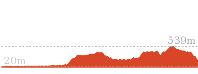
382 m
Hard track
A beautiful walk along part of the 11km Circuit walk, climbing up through a beautiful moist gully before emerging to drier forest and a nice viewpoint. The walk provides a great variety of scenery with a mixture of vegetation and some great boulder and cliff scenery along the way. The climbs and descents are pretty steep at times but not too long.

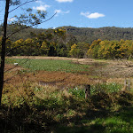
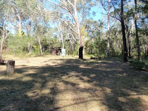
Mill Creek picnic area

This beautifully situated picnic area is located a short distance along an unsealed road, off Wisemans Ferry Rd, about 5.5km east of Wisemans Ferry. There are picnic tables, fireplaces, an information board and pit toilets. There is some excellent bush walking in the area with two signposted circuit walks starting from the end of the picnic area. There is a ‘large group’ camping area adjacent.
(0km) Mill Creek Picnic Area car park → 11km Nth rock platform
2.2 km
57 mins
301m
-81m
Hard track
From the Mill Creek picnic area (signposted on Wisemans Ferry Rd, about 6km east of Wisemans Ferry crossing), the walk crosses from the information signs to the the ‘Start/Finish’ walking track signpost at the far end of the picnic area.
Turn sharp left: From the signposts at the end of Mill Creek Picnic area, the walk crosses the picnic area to a visble handrail and steps going down to a wooden bridge. The walk crosses the bridge and bends to the left, following the bush track. After climbing gently around the hill for a while, the track climbs, steeply at times, through areas with beautiful boulder and moist forest scenery.
As the track climbs higher, it moves through drier forest and zigzags up the side of the hill. Keep an eye out for the track markers, ensuring you follow a cluster of markers up over some stepped rocks. After reaching the top of a ridge, the track swings to the left and climbs along the ridge line, passing over the small hill and down the ridge line on the other side. The track then passes a track marker on the right, keeping the large open rock platform to the left, and arrives at the junction on a small rock platform (the main track bends to the right here, going past a track marker with an old arrow nailed to the tree above it). There are minor tracks from this small rock platform to the nearby, large open platform with nice views.
11km circuit Nth Viewpoint
This informal, unfenced lookout is on a large rock platform on the northern part of the 11km Circuit, in Dharug National Park. The nice views and atmosphere make this a good spot for a break while doing the circuit walk.
Maps for the 11km Circuit northern lookout walk
You can download the PDF for this walk to print a map.
These maps below cover the walk and the wider area around the walk, they are worth carrying for safety reasons.
| Gunderman | 1:25 000 Map Series | 91313S GUNDERMAN | NSW-91313S |
| Lower Portland | 1:25 000 Map Series | 90312S LOWER PORTLAND | NSW-90312S |
| Gosford | 1:100 000 Map Series | 9131 GOSFORD | 9131 |
| St Albans | 1:100 000 Map Series | 9031 ST ALBANS | 9031 |
Cross sectional view of the 11km Circuit northern lookout bushwalking track
Analysis and summary of the altitude variation on the 11km Circuit northern lookout
Overview of this walks grade – based on the AS 2156.1 – 2001
Under this standard, a walk is graded based on the most difficult section of the walk.
| Length | 4.5 km | ||
| Time | 2 hrs 15 mins | ||
| . | |||
| Grade 4/6 Hard track |
AS 2156.1 | Gradient | Very steep (4/6) |
| Quality of track | Rough track, where fallen trees and other obstacles are likely (4/6) | ||
| Signs | Directional signs along the way (3/6) | ||
| Experience Required | Some bushwalking experience recommended (3/6) | ||
| Weather | Storms may impact on navigation and safety (3/6) | ||
| Infrastructure | Generally useful facilities (such as fenced cliffs and seats) (1/6) |
Some more details of this walks Grading
Here is a bit more details explaining grading looking at sections of the walk
Gradient
Around 2.1km of this walk is very steep, whilst the remaining 100m is flat with no steps.
Quality of track
Around 2.1km of this walk follows a rough track, where fallen trees and other obstacles are likely, whilst the remaining 100m follows a clear and well formed track or trail.
Signs
Around 2.1km of this walk has directional signs at most intersection, whilst the remaining 100m is clearly signposted.
Experience Required
Around 2.1km of this walk requires some bushwalking experience, whilst the remaining 100m requires no previous bushwalking experience.
weather
Around 2.1km of this walk is affected by storms that may impact your navigation and safety, whilst the remaining 100m is not usually affected by severe weather events (that would unexpectedly impact safety and navigation).
Infrastructure
This whole walk, 2.2km is close to useful facilities (such as fenced cliffs and seats).
Similar walks
A list of walks that share part of the track with the 11km Circuit northern lookout walk.
1.7 km Circuit
1 Hr
Moderate track
8.2 km Circuit
4 hrs 15 mins
Hard track
Other Nearby walks
A list of walks that start near the 11km Circuit northern lookout walk.
28.3 km One way
2 Days
Moderate track
4.4 km Return
2 hrs 15 mins
Moderate track
3.6 km Return
2 hrs
Moderate track
9.9 km Circuit
4 hrs 30 mins
Moderate track
27.3 km One way
2 Days
Hard track
2.2 km Return
1 hr 15 mins
Moderate track
4.3 km Return
2 hrs
Moderate track
4 km One way
2 hrs
Moderate track
8.3 km Return
3 hrs 15 mins
Moderate track
10.8 km Circuit
4 hrs 15 mins
Hard track
10.1 km Return
4 hrs 15 mins
Hard track
4.4 km Return
2 hrs
Hard track
Plan your trip to and from the walk here
The 11km Circuit northern lookout walk starts and ends at the Mill Creek Picnic Area car park (gps: -33.400835, 151.04778)
Your transport options to Mill Creek Picnic Area car park are by;
![]() Bus. Wisemans Ferry Dialacar provides a taxi style mini-bus service based in Wisemans Ferry. The cost is typically about per km (ex Wisemans Ferry). They will pick-up and drop-off from Sydney or the Central Coast and will happily drop walkers off or pick them up from tracks in the area. The cost for a pick-up from Gosford and drop off near Wisemans Ferry would be approximately 0 (please call for up-to-date pricing) and the minivan can carry up to 13 passengers. Phone: 0448 122 374 (get details)
Bus. Wisemans Ferry Dialacar provides a taxi style mini-bus service based in Wisemans Ferry. The cost is typically about per km (ex Wisemans Ferry). They will pick-up and drop-off from Sydney or the Central Coast and will happily drop walkers off or pick them up from tracks in the area. The cost for a pick-up from Gosford and drop off near Wisemans Ferry would be approximately 0 (please call for up-to-date pricing) and the minivan can carry up to 13 passengers. Phone: 0448 122 374 (get details)
![]() Car. There is free parking available.
Car. There is free parking available.
(get details)
Short URL = http://wild.tl/1cnl
Gallery images
There are other downloads I am still working on.
You will probably need to login to access these — still all free.
* KML (google earth file)
* GPX (GPS file)
Special Maps/ brochures
* A3 topo maps
* PDF with Lands Topo map base
* PDF with arial image (and map overlay)
I wanted to get the main site live first, this extra stuff will come in time.
Happy walking
Matt 🙂
Dubbo Gully to Upper Mangrove Cemetery

3 hrs 15 mins
7.2 km Return
450 m
Moderate track
An interesting walk with some great scenery, going to the small and interesting, historic cemetery at Upper Mangrove. Evidence of Aboriginal activity in the area stretches back at least 5000 years. Early European settlement in the area was concerned with timber, and produce farming, before the area also became established as a stop-off for travelers on the Great North Road.

(0km) Dubbo Gully Rd car park → Int of Dubbo Gully Rd and Upper Mangrove Creek Rd
2.5 km
1 hr 2 mins
104m
-277m
Moderate track
From the car park (a small clearing about 450m along the unsignposted Dubbo Gully Rd. Dubbo Gully Rd is found a by turning left off Waratah Rd when it becomes unsealed[1], about 4km from Mangrove Mountain shops), the walk follows the management trail down the hill and soon passes around a gate. There are some beautiful rock overhangs and scenery along this section of the walk. The walk continues to wind down the hill for a long while and eventually reaches the signposted intersection with the ‘Upper Mangrove Creek Rd’ (just before a bridge).
(2.49km) Int of Dubbo Gully Rd and Upper Mangrove Creek Rd → Upper Mangrove cemetery
1.1 km
22 mins
36m
-33m
Moderate track
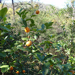
Continue straight: From the intersection, the walk follows the management trail (now Ten Mile Hollow Rd) and immediately crosses the longer bridge (leaving the shorter bridge with a gate to the right). The walk meanders along the trail for some time, passing an old ‘134’ sign to the right and a few old orange trees to the left. Soon after passing under some high voltage power lines, the walk arrives at a historic cemetery.
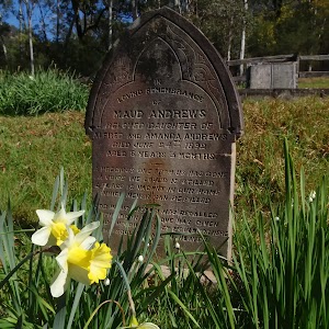
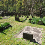
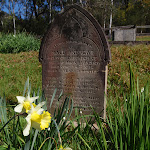
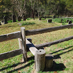
Upper Mangrove Cemetery
The Upper Mangrove Cemetery is on the western bank of Mangrove Creek, near the junction with Newmans Creek. The cemetery was part of St Thomas’ Church of England, however the church building was destroyed in the 2002 bushfires. Exploring the cemetery gives a glimpse into the history of the valley. You will find the stone remembering Alfred and Amanda Andrews who built ‘Fairview’ in 1922 and read of the loss of Leslie Starkey’s parents in 1913. On the other side of the road, up the hill, is the remains of of the old St Thomas’ Church building[3]. More info.
(3.6km) Upper Mangrove cemetery → Fairview Homestead
1.7 km
33 mins
56m
-45m
Moderate track
Continue straight: From the cemetery, the walk follows the management trail down the hill, leaving the cemetery to the left. The trail meanders along the valley for some time, passing a swampy area to the right and a large grassy clearing to the left. A short distance later, the walk reaches the signposted intersection with ‘Donny’s Track’[4].
Continue straight: From the intersection, the walk follows the management trail down the hill. The walk soon passes around a gate and continues a little further, passing around a swampy area to the left and immediately arriving at an intersection near a gate. The trail behind the gate leads to an old abandoned house and shed, which could provide some shelter.
Continue straight: From the intersection, the walk passes around the gate and follows the management trail steeply up the hill. The trail soon arrives at an old, abandoned house. At the end of this side trip, retrace your steps back to the main walk then Continue straight.
Fairview
Fairview (550 Ten Mile Hollow Rd, Mangrove Creek) is a property with a homestead, built in 1922 by Alfred Andrews. The homestead and adjoining slab hut are now fenced to protect them, however the large corrugated iron shed on the south side is still open. The homestead was once a popular rest area for people traveling the North Road, via the Simpson track. The home was privately owned until 1973 when Gosford City Council acquired the land to protect the catchment area. The home was rented until 2002, when the tenants moved due to the threat of bushfires. The building is now in poor condition and the ‘Friends of Fairview’ are exploring ways to save the building and restore the history of the valley. Save Fairview More info.
Maps for the Dubbo Gully to Upper Mangrove Cemetery walk
You can download the PDF for this walk to print a map.
These maps below cover the walk and the wider area around the walk, they are worth carrying for safety reasons.
| Mangrove | 1:25 000 Map Series | 91313N MANGROVE | NSW-91313N |
| Gosford | 1:100 000 Map Series | 9131 GOSFORD | 9131 |
Cross sectional view of the Dubbo Gully to Upper Mangrove Cemetery bushwalking track
Analysis and summary of the altitude variation on the Dubbo Gully to Upper Mangrove Cemetery
Overview of this walks grade – based on the AS 2156.1 – 2001
Under this standard, a walk is graded based on the most difficult section of the walk.
| Length | 7.2 km | ||
| Time | 3 hrs 15 mins | ||
| . | |||
| Grade 3/6 Moderate track |
AS 2156.1 | Gradient | Short steep hills (3/6) |
| Quality of track | Clear and well formed track or trail (2/6) | ||
| Signs | Directional signs along the way (3/6) | ||
| Experience Required | No experience required (1/6) | ||
| Weather | Weather generally has little impact on safety (1/6) | ||
| Infrastructure | Limited facilities, not all cliffs are fenced (3/6) |
Some more details of this walks Grading
Here is a bit more details explaining grading looking at sections of the walk
Gradient
Around 2.5km of this walk has short steep hills, whilst the remaining 1.1km has gentle hills with occasional steps.
Quality of track
This whole walk, 3.6km follows a clear and well formed track or trail.
Signs
Around 2.5km of this walk has directional signs at most intersection, whilst the remaining 1.1km is clearly signposted.
Experience Required
This whole walk, 3.6km requires no previous bushwalking experience.
weather
This whole walk, 3.6km is not usually affected by severe weather events (that would unexpectedly impact safety and navigation).
Infrastructure
This whole walk, 3.6km has limited facilities (such as not all cliffs fenced).
Similar walks
A list of walks that share part of the track with the Dubbo Gully to Upper Mangrove Cemetery walk.
24.3 km Circuit
2 Days
Hard track
27.3 km One way
2 Days
Hard track
28.3 km One way
2 Days
Moderate track
Other Nearby walks
A list of walks that start near the Dubbo Gully to Upper Mangrove Cemetery walk.
11.2 km One way
4 hrs 30 mins
Hard track
15 km One way
5 hrs 30 mins
Hard track
8.3 km Return
3 hrs 15 mins
Moderate track
10.8 km Circuit
4 hrs 15 mins
Hard track
10.1 km Return
4 hrs 15 mins
Hard track
4.4 km Return
2 hrs
Hard track
5.6 km One way
2 hrs 45 mins
Hard track
8.1 km One way
3 hrs 30 mins
Hard track
17 km One way
6 hrs 30 mins
Hard track
33.7 km One way
2 Days
Hard track
11 km One way
3 hrs 30 mins
Easy track

6 km One way
2 hrs 30 mins
Hard track
Plan your trip to and from the walk here
The Dubbo Gully to Upper Mangrove Cemetery walk starts and ends at the Dubbo Gully Rd car park (gps: -33.293017, 151.15119)
Your main transport option to Dubbo Gully Rd car park is by;
![]() Car. There is free parking available.
Car. There is free parking available.
(get details)
Short URL = http://wild.tl/dgtumc
Gallery images
There are other downloads I am still working on.
You will probably need to login to access these — still all free.
* KML (google earth file)
* GPX (GPS file)
Special Maps/ brochures
* A3 topo maps
* PDF with Lands Topo map base
* PDF with arial image (and map overlay)
I wanted to get the main site live first, this extra stuff will come in time.
Happy walking
Matt 🙂
11km Circuit
And Walk
11km Circuit
4 hrs 15 mins
8.2 km Circuit
634 m
Hard track
This excellent circuit walk offers a lot of beautiful scenery and views. Although shorter than the name suggests, it is a reasonably tough walk, with some steep rocky sections. The sections in the gullies and valleys are mostly very moist with lots of ferns, while the higher sections are through drier forest, so there is quite a bit of variety. There are also some lovely cliffs and boulder scenery at various points around the walk.


Mill Creek picnic area
This beautifully situated picnic area is located a short distance along an unsealed road, off Wisemans Ferry Rd, about 5.5km east of Wisemans Ferry. There are picnic tables, fireplaces, an information board and pit toilets. There is some excellent bush walking in the area with two signposted circuit walks starting from the end of the picnic area. There is a ‘large group’ camping area adjacent.
(0km) Mill Creek Picnic Area car park → Int of Grass Tree and 11km circuits
870 m
24 mins
84m
-48m
Moderate track
From the Mill Creek picnic area (signposted on Wisemans Ferry Rd, about 6km east of Wisemans Ferry crossing), the walk crosses from the information signs to the the ‘Start/Finish’ walking track signpost at the far end of the picnic area.
Continue straight: From the ‘Start/Finish’ walking track signpost at the end of the picnic area, the walk follows the bush track and immediately takes the right hand branch at a fork in the track (the other track is the return leg of the Grass Tree circuit). The walk passes through a mix of closed in, dense vegetation and more open forest with some beautiful views and lots of grasstrees. After crossing a creek using wooden steps and a concreted stone path, the track climbs more steeply before dropping to the signposted intersection of the ’11km Walking Track’ and ‘1.5km Grass Tree Circuit’.
Continue straight: From the ‘Start/Finish’ walking track signpost at the end of the picnic area, the walk follows the bush track and immediately takes the right hand branch at a fork in the track (the other track is the return leg of the Grass Tree circuit). The walk passes through a mix of closed in, dense vegetation and more open forest with some beautiful views and lots of grasstrees. After crossing a creek using wooden steps and a concreted stone path, the track climbs more steeply before dropping to the signposted intersection of the ’11km Walking Track’ and ‘1.5km Grass Tree Circuit’.
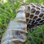
Grasstrees

The beautiful Grasstree is one of the icons of the Australian bush. It is a very slow growing plant, with the trunk typically only growing about one cm per year. These plants can grow and survive for several hundred years. The trunk is usually black, apparently a result of bushfires. As with some other native plants, fires can actually promote flowering and further growth. More info.
(0.87km) Int of Grass Tree and 11km circuits → Int of 11km circuit and Link track
2.6 km
1 hr 9 mins
257m
-92m
Hard track
Turn right: From the intersection, the walk follows the ’11km Walking Track’ arrow along the bush track. The track climbs for a while, with nice views down into the gully, before dropping to a picturesque creek crossing marked with a small ‘walker arrow’. From here the track climbs steeply for a short distance, then passes another track marker at the start of a section with beautiful rock overhangs and boulders. The track then drops to another creek crossing, marked with a small walker sign on a boulder in the middle of the creek, beneath a huge tree with impressive roots draping over the rocks.
Turn right: From the creek, the walk follows the walker arrow along the bush track, going downstream and keeping the creek to the right. This section of the walk has several steep climbs and plenty of great scenery. After meandering for some time the walk passes a regenerating bush track, to the right (marked with a walker post and old arrows on the trees), and continues, crossing a gully marked with walker arrows in both directions. After crossing another gully (unmarked), the walk climbs very steeply, passing a track marker and climbing further to reach an intersection at the top of the hill (very faint bush track to the right), marked with two arrow track markers on a post.
Turn right: From the creek, the walk follows the walker arrow along the bush track, going downstream and keeping the creek to the right. This section of the walk has several steep climbs and plenty of great scenery. After meandering for some time the walk passes a regenerating bush track, to the right (marked with a walker post and old arrows on the trees), and continues, crossing a gully marked with walker arrows in both directions. After crossing another gully (unmarked), the walk climbs very steeply, passing a track marker and climbing further to reach an intersection at the top of the hill (very faint bush track to the right), marked with two arrow track markers on a post.
(3.47km) Int of 11km circuit and Link track → 11km Nth rock platform
2.4 km
1 hr 8 mins
212m
-194m
Hard track
Continue straight: From the intersection, the walk follows the lower track arrow (left) on the signpost, along the bush track. The track immediately bends to the right and goes steeply down the hill. This section of the walk has some beautiful scenery with great boulder formations and beautiful forest and valley views. It also has some very steep sections as it drops and climbs through two gullies (plus a third minor tributary) before reaching an intersection at the top of a ridge, on a small rock platform immediately after passing a track marker (the main track bends to the left here). There are minor tracks from here to a much larger rock platform nearby with some nice views.
11km circuit Nth Viewpoint
This informal, unfenced lookout is on a large rock platform on the northern part of the 11km Circuit, in Dharug National Park. The nice views and atmosphere make this a good spot for a break while doing the circuit walk.
(5.91km) 11km Nth rock platform → Mill Creek Picnic Area car park
2.2 km
57 mins
81m
-301m
Hard track
Turn left: From the small rock platform, the walk goes west along the bush track, leaving the much larger rock platform to the right. The track soon passes a track marker on the left and gently climbs up the ridge line, over the small hill and down the ridge line on the other side. The track then bends to the right and descends steeply, zigzagging down the side of the hill. The walk passes numerous track markers along the way and eventually descends into the more shaded and moist lower part of the valley. There is beautiful scenery through this section, as the walk descends, steeply at times, then crosses a wooden bridge and climbs some steps to the edge of the Mill Creek Picnic area. From here it is a short walk across the picnic area to the visible walking track signpost.
Turn sharp right: From the ‘Start/Finish’ walking track signpost at the end of the Mill Creek picnic area, the walk crosses the picnic area to the car park (Mill Creek picnic area is signposted on Wisemans Ferry Rd, about 6km east of Wisemans Ferry crossing).
Turn sharp right: From the ‘Start/Finish’ walking track signpost at the end of the Mill Creek picnic area, the walk crosses the picnic area to the car park (Mill Creek picnic area is signposted on Wisemans Ferry Rd, about 6km east of Wisemans Ferry crossing).
Maps for the 11km Circuit walk
You can download the PDF for this walk to print a map.
These maps below cover the walk and the wider area around the walk, they are worth carrying for safety reasons.
| Gunderman | 1:25 000 Map Series | 91313S GUNDERMAN | NSW-91313S |
| Lower Portland | 1:25 000 Map Series | 90312S LOWER PORTLAND | NSW-90312S |
| Gosford | 1:100 000 Map Series | 9131 GOSFORD | 9131 |
| St Albans | 1:100 000 Map Series | 9031 ST ALBANS | 9031 |
Cross sectional view of the 11km Circuit bushwalking track
Analysis and summary of the altitude variation on the 11km Circuit
Overview of this walks grade – based on the AS 2156.1 – 2001
Under this standard, a walk is graded based on the most difficult section of the walk.
| Length | 8.2 km | ||
| Time | 4 hrs 15 mins | ||
| . | |||
| Grade 4/6 Hard track |
AS 2156.1 | Gradient | Very steep (4/6) |
| Quality of track | Rough track, where fallen trees and other obstacles are likely (4/6) | ||
| Signs | Directional signs along the way (3/6) | ||
| Experience Required | Some bushwalking experience recommended (3/6) | ||
| Weather | Storms may impact on navigation and safety (3/6) | ||
| Infrastructure | Limited facilities, not all cliffs are fenced (3/6) |
Some more details of this walks Grading
Here is a bit more details explaining grading looking at sections of the walk
Gradient
6km of this walk is very steep and another 1.6km has short steep hills. The remaining (210m) is flat with no steps.
Quality of track
6km of this walk follows a rough track, where fallen trees and other obstacles are likely and another 1.6km follows a formed track, with some branches and other obstacles. The remaining (210m) follows a clear and well formed track or trail.
Signs
Around 8km of this walk has directional signs at most intersection, whilst the remaining 210m is clearly signposted.
Experience Required
Around 8km of this walk requires some bushwalking experience, whilst the remaining 210m requires no previous bushwalking experience.
weather
Around 7km of this walk is affected by storms that may impact your navigation and safety, whilst the remaining 970m is not usually affected by severe weather events (that would unexpectedly impact safety and navigation).
Infrastructure
Around 5km of this walk has limited facilities (such as not all cliffs fenced), whilst the remaining 3.1km is close to useful facilities (such as fenced cliffs and seats).
Similar walks
A list of walks that share part of the track with the 11km Circuit walk.
1.7 km Circuit
1 Hr
Moderate track
4.5 km Return
2 hrs 15 mins
Hard track
Other Nearby walks
A list of walks that start near the 11km Circuit walk.
28.3 km One way
2 Days
Moderate track
4.4 km Return
2 hrs 15 mins
Moderate track
3.6 km Return
2 hrs
Moderate track
9.9 km Circuit
4 hrs 30 mins
Moderate track
27.3 km One way
2 Days
Hard track
2.2 km Return
1 hr 15 mins
Moderate track
4.3 km Return
2 hrs
Moderate track
4 km One way
2 hrs
Moderate track
8.3 km Return
3 hrs 15 mins
Moderate track
10.8 km Circuit
4 hrs 15 mins
Hard track
10.1 km Return
4 hrs 15 mins
Hard track
4.4 km Return
2 hrs
Hard track
Plan your trip to and from the walk here
The 11km Circuit walk starts and ends at the Mill Creek Picnic Area car park (gps: -33.400835, 151.04778)
Your transport options to Mill Creek Picnic Area car park are by;
![]() Bus. Wisemans Ferry Dialacar provides a taxi style mini-bus service based in Wisemans Ferry. The cost is typically about per km (ex Wisemans Ferry). They will pick-up and drop-off from Sydney or the Central Coast and will happily drop walkers off or pick them up from tracks in the area. The cost for a pick-up from Gosford and drop off near Wisemans Ferry would be approximately 0 (please call for up-to-date pricing) and the minivan can carry up to 13 passengers. Phone: 0448 122 374 (get details)
Bus. Wisemans Ferry Dialacar provides a taxi style mini-bus service based in Wisemans Ferry. The cost is typically about per km (ex Wisemans Ferry). They will pick-up and drop-off from Sydney or the Central Coast and will happily drop walkers off or pick them up from tracks in the area. The cost for a pick-up from Gosford and drop off near Wisemans Ferry would be approximately 0 (please call for up-to-date pricing) and the minivan can carry up to 13 passengers. Phone: 0448 122 374 (get details)
![]() Car. There is free parking available.
Car. There is free parking available.
(get details)
Short URL = http://wild.tl/22
Gallery images
There are other downloads I am still working on.
You will probably need to login to access these — still all free.
* KML (google earth file)
* GPX (GPS file)
Special Maps/ brochures
* A3 topo maps
* PDF with Lands Topo map base
* PDF with arial image (and map overlay)
I wanted to get the main site live first, this extra stuff will come in time.
Happy walking
Matt 🙂
Devines Hill and Finchs Line circuit
And Walk
Devines Hill and Finchs Line circuit

4 hrs 30 mins
9.9 km Circuit
547 m
Moderate track
A great walk with a mixture of historic remnants of the Old Great North Rd, and some beautiful views over the Hawkesbury river and other valleys. Most of this walk follows parts of the convict built road, and a number of information signs along the way give a good insight into the construction and history of the road, making the walk more interesting. The last section of the walk, along Wisemans Ferry Rd, has some great views of the cliffs above. The historic Thomas James bridge, just before the end of the walk, is the oldest in-use bridge on mainland Australia.


Wisemans Ferry
Wisemans Ferry village is on the banks of the Hawkesbury river, NSW. The town, and nearby car ferry, is named after Solomon Wiseman, a former convict who received a land grant in the area and established the ferry service. The town is a popular day trip and weekend destination from Sydney. There are several good spots to eat in town, including bistros at the Wisemans Ferry Inn and the Wisemans Ferry Bowling club, and takeaway food from Bush Bites cafe. The Riverbend Restaurant can be found in the ‘Retreat at Wisemans’ for finer dining. The area has some great walking and interesting history surrounding the convict built Old Great North Road. More info.
Old Great North Road
The historic Great North Road was built using convict labour between 1826 and 1836 (this section south of Wollombi was completed in 1832). The road formed a link between Sydney and the Hunter Valley, including Newcastle. There are visible remnants of the original work in bridges, retaining walls and other structures along the way. The ‘Convict Trail Project’ has member groups involved in the conservation of historical remnants along the road. The Convict Trail Project and the NPWS have erected information signs at various points to illustrate the history. The Convict Trail Project has an excellent website for further reading. More info.
(0km) Int of Wisemans Ferry Rd and OGNR → Hangmans Rock
1.1 km
31 mins
127m
-49m
Moderate track
From the car park and intersection on Wisemans Ferry Rd (about 500m west of the car ferry), the walk passes around a gate, passes an information sign, and follows the ‘Old Great North Road’ up the hill. This section of the walk winds up the hill, passing numerous cuttings and retaining walls built with convict labour. There are several information signs on the way, making the walk more interesting. The walk then arrives at the signposted “Hangman’s Rock”.
Hangmans Rock
Hangmans Rock is beside the historic Old Great North Road, near Wisemans Ferry, NSW. This beautiful sandstone cave/overhang has some steps and a bench seat cut into it and is part of the history of the convict built OGNR. It is uncertain what purpose the spot served, but stories that convicts were hanged through the hole in the roof of the cave appear unlikely to be true, despite giving a name to the atmospheric spot. More info.
(1.09km) Hangmans Rock → Int of OGNR and Finchs Line
1.1 km
27 mins
94m
-16m
Moderate track
Continue straight: From Hangman’s Rock, the walk follows the management trail gently up the hill. The trail bends back and forth as it gently climbs. Another information sign indicates the probable site of a stockade to hold the “more troublesome convicts”. A little further along, the walk passes around a gate and reaches the intersection with “Shepherd’s Gully Road”. There is another information sign at this intersection.
Veer right: From the intersection, the walk follows the ‘Finchs Line 500m’ arrow along the management trail, soon passing a culvert information display. The trail continues further up the gentle hill to reach the signposted intersection with the ‘Finchs Line’.
Veer right: From the intersection, the walk follows the ‘Finchs Line 500m’ arrow along the management trail, soon passing a culvert information display. The trail continues further up the gentle hill to reach the signposted intersection with the ‘Finchs Line’.
(2.2km) Int of OGNR and Finchs Line → Finchs Line Lookout Int
1.8 km
39 mins
82m
-74m
Moderate track
Turn right: From the intersection, the walk follows the ‘Finchs Line’ arrow along the management trail. This long meandering section is quite interesting with a nice variety of forest scenery and remnants of the road construction. There are also frequent glimpses of the Hawkesbury river and Wisemans Ferry township through the trees. The walk eventually comes to an unmarked intersection with a bush track (with the management trail bending to the left).
(4.03km) Finchs Line Lookout Int → Finchs Line Lookout
50 m
3 mins
0m
-39m
Moderate track
Continue straight: From the intersection, the walk follows the bush track gently down the hill a very short distance to arrive at an informal, unfenced lookout with stunning views across Wisemans Ferry and the Hawkesbury river. At the end of this side trip, retrace your steps back to the main walk then Turn sharp right.
Finchs Line lookout
This informal, unfenced (and unnamed) lookout is just off the walking track along the historic Finchs Line Road, near Wisemans Ferry, NSW. There are beautiful views down across the Hawkesbury river and Wisemans Ferry township from here.
(4.03km) Finchs Line Lookout Int → Finchs Line Sth viewpoint
1.2 km
27 mins
40m
-97m
Moderate track
Veer left: From the intersection, the walk follows the management trail steeply up the hill. This section of walk meanders for a while, passing an information sign about the ‘Abandoned’ works on the Finchs Line, before coming to a series of spots on the right with beautiful views down across the Hawkesbury river and Wisemans Ferry township. The walk continues along these viewing spots to the large rock outcrop, on the right, just as the trail bends to the left and heads away from the cliff line.
Finchs Line viewpoint
This informal, unfenced (and unnamed) lookout is on the trail along the historic Finchs Line Rd near Wisemans Ferry, NSW. The viewpoint sits on a beautiful outcrop of boulders and provides stunning views down across the Hawkesbury river and Wisemans Ferry township.
(5.21km) Finchs Line Sth viewpoint → Walk Bikes Signpost
970 m
25 mins
79m
-63m
Moderate track
Continue straight: From the rock outcrop, the walk follows the management trail away from the cliff line. The trail switches to the other side of the ridge and offers some beautiful views across the valleys behind. The trail starts to drop reasonably steeply and arrives at a junction with a bush track, marked with a sign indicating bikes must be walked.
(6.17km) Walk Bikes Signpost → Int of Finchs Line and Wisemans Ferry Rd
1.2 km
32 mins
42m
-189m
Moderate track
Turn left: From the signpost, the walk follows the bush track as it zigzags down a steep hill, along the path of Finchs Line road. There are some beautiful views away from the track and a lot of ferns, grasstrees and vines surrounding the track. After winding down the hill for quite a while the walk arrives at the intersection with Wisemans Ferry Rd, signposted with ‘Finchs Line Walking Track’ (about 1.8km east of the car ferry).
(7.4km) Int of Finchs Line and Wisemans Ferry Rd → Thomas James Bridge
2.4 km
46 mins
80m
-40m
Moderate track
Continue straight: From the intersection (about 1.8km east of the car ferry), the walk follows Wisemans Ferry Rd, immediately passing a noticeable sandstone gateway to the left. The road continues, with the Hawkesbury river to the left, and some great views of the cliffs to the right, for quite a while before reaching the northern end of the car ferry (Wisemans Ferry), signposted as the ‘Gosford Approach’.
Continue straight: From the northern end (Gosford approach) of Wisemans Ferry, the walk follows Wisemans Ferry Rd, keeping the river to the left. The walk soon arrives at the historic Thomas James Bridge.
Continue straight: From the northern end (Gosford approach) of Wisemans Ferry, the walk follows Wisemans Ferry Rd, keeping the river to the left. The walk soon arrives at the historic Thomas James Bridge.
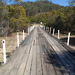
Thomas James Bridge
The historic Thomas James Bridge is on Wisemans Ferry Rd, NSW. This is the oldest in-use bridge on mainland Australia (Tasmania has older bridges) and is one of several convict built bridges along the Old Great North Road. The bridge was built during 1830 (the timber deck is more recent) and was named after the overseer of ‘Road Party 25’ which built the bridge. More info.
(9.81km) Thomas James Bridge → Int of Wisemans Ferry Rd and OGNR
100 m
3 mins
3m
-16m
Moderate track
Continue straight: From the bridge, the walk follows Wisemans Ferry Rd gently up the hill for a very short distance and arrives at the car park and intersection with The Old Great North Road (about 500m west of Wisemans Ferry crossing).
Maps for the Devines Hill and Finchs Line circuit walk
You can download the PDF for this walk to print a map.
These maps below cover the walk and the wider area around the walk, they are worth carrying for safety reasons.
| Gunderman | 1:25 000 Map Series | 91313S GUNDERMAN | NSW-91313S |
| Lower Portland | 1:25 000 Map Series | 90312S LOWER PORTLAND | NSW-90312S |
| St Albans | 1:25 000 Map Series | 90312N ST ALBANS | NSW-90312N |
| Gosford | 1:100 000 Map Series | 9131 GOSFORD | 9131 |
| St Albans | 1:100 000 Map Series | 9031 ST ALBANS | 9031 |
Cross sectional view of the Devines Hill and Finchs Line circuit bushwalking track
Analysis and summary of the altitude variation on the Devines Hill and Finchs Line circuit
Overview of this walks grade – based on the AS 2156.1 – 2001
Under this standard, a walk is graded based on the most difficult section of the walk.
| Length | 9.9 km | ||
| Time | 4 hrs 30 mins | ||
| . | |||
| Grade 3/6 Moderate track |
AS 2156.1 | Gradient | Short steep hills (3/6) |
| Quality of track | Formed track, with some branches and other obstacles (3/6) | ||
| Signs | Directional signs along the way (3/6) | ||
| Experience Required | Some bushwalking experience recommended (3/6) | ||
| Weather | Weather generally has little impact on safety (1/6) | ||
| Infrastructure | Limited facilities, not all cliffs are fenced (3/6) |
Some more details of this walks Grading
Here is a bit more details explaining grading looking at sections of the walk
Gradient
5km of this walk has gentle hills with occasional steps and another 3km has short steep hills. The remaining (1.8km) is flat with no steps.
Quality of track
6km of this walk follows a clear and well formed track or trail and another 2.5km follows a smooth and hardened path. The remaining (1.2km) follows a formed track, with some branches and other obstacles.
Signs
Around 5km of this walk has directional signs at most intersection, whilst the remaining 4.7km is clearly signposted.
Experience Required
Around 9km of this walk requires no previous bushwalking experience, whilst the remaining 1.2km requires some bushwalking experience.
weather
This whole walk, 10km is not usually affected by severe weather events (that would unexpectedly impact safety and navigation).
Infrastructure
Around 7km of this walk has limited facilities (such as not all cliffs fenced), whilst the remaining 2.4km is close to useful facilities (such as fenced cliffs and seats).
Similar walks
A list of walks that share part of the track with the Devines Hill and Finchs Line circuit walk.
2.2 km Return
1 hr 15 mins
Moderate track
3.6 km Return
2 hrs
Moderate track
4 km One way
2 hrs
Moderate track
4.3 km Return
2 hrs
Moderate track
4.4 km Return
2 hrs 15 mins
Moderate track
27.3 km One way
2 Days
Hard track
Other Nearby walks
A list of walks that start near the Devines Hill and Finchs Line circuit walk.
28.3 km One way
2 Days
Moderate track
8.2 km Circuit
4 hrs 15 mins
Hard track
4.5 km Return
2 hrs 15 mins
Hard track
1.7 km Circuit
1 Hr
Moderate track
8.3 km Return
3 hrs 15 mins
Moderate track
10.8 km Circuit
4 hrs 15 mins
Hard track
10.1 km Return
4 hrs 15 mins
Hard track
4.4 km Return
2 hrs
Hard track
24.3 km Circuit
2 Days
Hard track
7.2 km Return
3 hrs 15 mins
Moderate track
426 m Return
20 mins
Moderate track
6 km One way
2 hrs 30 mins
Hard track
Plan your trip to and from the walk here
The Devines Hill and Finchs Line circuit walk starts and ends at the Int of Wisemans Ferry Rd and OGNR (gps: -33.375218, 150.98486)
Your transport options to Int of Wisemans Ferry Rd and OGNR are by;
![]() Bus. Wisemans Ferry Dialacar provides a taxi style mini-bus service based in Wisemans Ferry. The cost is typically about per km (ex Wisemans Ferry). They will pick-up and drop-off from Sydney or the Central Coast and will happily drop walkers off or pick them up from tracks in the area. The cost for a pick-up from Gosford and drop off near Wisemans Ferry would be approximately 0 (please call for up-to-date pricing) and the minivan can carry up to 13 passengers. Phone: 0448 122 374 (get details)
Bus. Wisemans Ferry Dialacar provides a taxi style mini-bus service based in Wisemans Ferry. The cost is typically about per km (ex Wisemans Ferry). They will pick-up and drop-off from Sydney or the Central Coast and will happily drop walkers off or pick them up from tracks in the area. The cost for a pick-up from Gosford and drop off near Wisemans Ferry would be approximately 0 (please call for up-to-date pricing) and the minivan can carry up to 13 passengers. Phone: 0448 122 374 (get details)
![]() Car. There is free parking available.
Car. There is free parking available.
(get details)
Short URL = http://wild.tl/dhaflc
Gallery images
There are other downloads I am still working on.
You will probably need to login to access these — still all free.
* KML (google earth file)
* GPX (GPS file)
Special Maps/ brochures
* A3 topo maps
* PDF with Lands Topo map base
* PDF with arial image (and map overlay)
I wanted to get the main site live first, this extra stuff will come in time.
Happy walking
Matt 🙂
Dubbo Gully and Ten Mile Hollow Circuit (via Clares Bridge)

2 Days
24.3 km Circuit
1117 m
Hard track
This two day (or ten hour) walk follows several historic roads, now closed to traffic. Starting with a walk down to Dubbo Gully and past an old cemetery, you will then explore some old farms before coming to Simpsons Track. Here, head up the hill to come to the Ten Mile Hollow Campsite. The next day you will follow the Old Great North Road to Clare’s Bridge (second oldest bridge on mainland Australia). A bit further along the Old Great North Road, you then head down Donny’s track and return to the start via Dubbo Gully. A great way to explore the history and beauty of the area.


(0km) Dubbo Gully Rd car park → Upper Mangrove cemetery
3.6 km
1 hr 24 mins
140m
-310m
Moderate track
From the car park (a small clearing about 450m along the unsignposted Dubbo Gully Rd. Dubbo Gully Rd is found a by turning left off Waratah Rd when it becomes unsealed[1], about 4km from Mangrove Mountain shops), the walk follows the management trail down the hill and soon passes around a gate. There are some beautiful rock overhangs and scenery along this section of the walk. The walk continues to wind down the hill for a long while and eventually reaches the signposted intersection with the ‘Upper Mangrove Creek Rd’ (just before a bridge).
Continue straight: From the intersection, the walk follows the management trail (now Ten Mile Hollow Rd) and immediately crosses the longer bridge (leaving the shorter bridge with a gate to the right). The walk meanders along the trail for some time, passing an old ‘134’ sign to the right and a few old orange trees to the left. Soon after passing under some high voltage power lines, the walk arrives at a historic cemetery.
Continue straight: From the intersection, the walk follows the management trail (now Ten Mile Hollow Rd) and immediately crosses the longer bridge (leaving the shorter bridge with a gate to the right). The walk meanders along the trail for some time, passing an old ‘134’ sign to the right and a few old orange trees to the left. Soon after passing under some high voltage power lines, the walk arrives at a historic cemetery.
Upper Mangrove Cemetery
The Upper Mangrove Cemetery is on the western bank of Mangrove Creek, near the junction with Newmans Creek. The cemetery was part of St Thomas’ Church of England, however the church building was destroyed in the 2002 bushfires. Exploring the cemetery gives a glimpse into the history of the valley. You will find the stone remembering Alfred and Amanda Andrews who built ‘Fairview’ in 1922 and read of the loss of Leslie Starkey’s parents in 1913. On the other side of the road, up the hill, is the remains of of the old St Thomas’ Church building[3]. More info.
(3.6km) Upper Mangrove cemetery → Int of Ten Mile Hollow Rd and Donnys track
740 m
15 mins
27m
-21m
Moderate track
Continue straight: From the cemetery, the walk follows the management trail down the hill, leaving the cemetery to the left. The trail meanders along the valley for some time, passing a swampy area to the right and a large grassy clearing to the left. A short distance later, the walk reaches the signposted intersection with ‘Donny’s Track’[4].
(4.35km) Int of Ten Mile Hollow Rd and Donnys track → Int below Fairview Homestead
810 m
15 mins
19m
-22m
Moderate track
Continue straight: From the intersection, the walk follows the management trail down the hill. The walk soon passes around a gate and continues a little further, passing around a swampy area to the left and immediately arriving at an intersection near a gate. The trail behind the gate leads to an old abandoned house and shed, which could provide some shelter.
(5.15km) Int below Fairview Homestead → Fairview Homestead
120 m
3 mins
10m
-2m
Moderate track
Continue straight: From the intersection, the walk passes around the gate and follows the management trail steeply up the hill. The trail soon arrives at an old, abandoned house. At the end of this side trip, retrace your steps back to the main walk then Turn right.
Fairview
Fairview (550 Ten Mile Hollow Rd, Mangrove Creek) is a property with a homestead, built in 1922 by Alfred Andrews. The homestead and adjoining slab hut are now fenced to protect them, however the large corrugated iron shed on the south side is still open. The homestead was once a popular rest area for people traveling the North Road, via the Simpson track. The home was privately owned until 1973 when Gosford City Council acquired the land to protect the catchment area. The home was rented until 2002, when the tenants moved due to the threat of bushfires. The building is now in poor condition and the ‘Friends of Fairview’ are exploring ways to save the building and restore the history of the valley. Save Fairview More info.
(5.15km) Int below Fairview Homestead → Int of Ten Mile Hollow Rd and Simpsons track
2.5 km
47 mins
60m
-66m
Moderate track
Turn left : From the intersection, the walk follows the management trail, leaving the gate to the right and keeping the swampy area to the left. After passing a grassy clearing and old trail to the left, the walk soon passes a ‘Heritage Road Wall AND Culvert Protection’ signpost[5]. Allow some time to look at the old road retaining wall sections along here. The walk continues to meander close to the creek, passing amongst some nice trees and some large clearings. The walk then passes a smaller clearing, to the left, with a padlocked steel ‘Monitoring Well’. Soon after this, the walk passes through another long clearing with the remains of an old wooden fenced cattle yard. The walk then crosses a small creek and passes through to another clearing, passing a couple of boulders on the left with ‘Convict Trail’ information signs[6][7] and a visitors book, to arrive at the intersection with the Simpson track, marked with a National Parks walkers signpost[8].
Convict Trail plaque and log book
(7.7km) Int of Ten Mile Hollow Rd and Simpsons track → Simpsons Cave
2.4 km
49 mins
135m
-70m
Moderate track
Turn right: From the intersection, this walk follows the NPWS arrow post west along the flat trail (Simpsons Track), further up the Ten Mile Hollow gully. The trail leaves the large clearing and soon passes a series of smaller clearings. After crossing a few creeks, the trail enters the thicker bush. About 1.7km from the large clearing, the trail enters the signposted ‘Dharug National Park’. From here, the walk continues up the trail and, after about 750m and a distinct change in vegetation, the trail comes to the base of a large cliff and a couple of caves, up the hill on the left.
Simpsons Cave
Simpsons Cave is an informal name given to a sandstone overhang on the Simpson Track, about 2.5km east of the junction with the Old Great North Road. The cave is perched high on the side of the old road and looks north over Ten Mile Hollow valley. The cave has an outward sloping floor and is best viewed from the track.
(10.07km) Simpsons Cave → Ten Mile Hollow
2.5 km
47 mins
108m
-39m
Moderate track
Continue straight: From the caves, this walk follows the management trail (Simpsons Track) up the hill keeping the valley to the right. After winding up the hill for quiet some time, the trail leads under some high-tension power lines in a large clearing. About 200m past this clearing, the main trail comes to a signposted intersection with the Old Great North Road at Ten Mile Hollow and a ‘Simpsons Track’ sign[12] pointing back along the trail.
Ten Mile Hollow
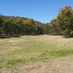
This large, open campsite is found next to the Old Great North Road, at the top of the Simpson Track. The campsite is great for people walking or cycling in the area. There is fairly new hybrid toilet, a few fire circles and plenty of places to pitch some tents. There is a water tank next to the toilet – if this is empty, there is sometimes water in Ten Mile Hollow creek a short distance north along the OGNR (otherwise the Wat Buddha Dhamma, about 600m south along the OGNR, provide a water tank for visitors). Treat water before drinking.
The area was formally a stockade (a camp) for the convicts who built the road in c.1830. Later the area was named ‘Snodgrass Valley’ and plans to build a town were developed, neither the name nor the town proved popular (even at 2 pounds an acre). Solomon Wiseman (of Wisemans Ferry fame) was given 100 acres to build an inn, however it is not clear if the inn was ever built. More info.
The area was formally a stockade (a camp) for the convicts who built the road in c.1830. Later the area was named ‘Snodgrass Valley’ and plans to build a town were developed, neither the name nor the town proved popular (even at 2 pounds an acre). Solomon Wiseman (of Wisemans Ferry fame) was given 100 acres to build an inn, however it is not clear if the inn was ever built. More info.
End of day 1
This is the planned overnight stay for the end of day 1, happy camping.
(12.57km) Ten Mile Hollow → Clares Bridge
1.2 km
22 mins
33m
-6m
Moderate track
Turn right: From Ten Mile Hollow, this walk follows the ‘Clares Bridge’ sign[14] along the OGNR, as it soon bends to the left. The trail narrows and comes to an old bridge (with a timber base). The walk crosses the bridge (and Ten Mile Hollow Creek) and heads around the gate. The walk follows the overgrown management trail through the bush for a while, coming to a white wooden barricade. Heading around the barricade, the walk comes to a clearing and signpost just before Clare’s Bridge[15].
Clares Bridge
Clare’s Bridge, on the Old Great North Road, is about 1km north of Ten Mile Hollow camping area. This, and a number of other bridges, were built during the construction of the old road. Clare’s Bridge is the most visually spectacular of the bridges. The second oldest bridge on mainland Australia (The oldest being Thomas James Bridge), it is built of sandstone blocks and has a wonderful, sweeping retaining wall. The sweeping design gives full view of the craftsmanship to those passing by. Much work has been done by NPWS and Gosford Council to restore the bridge. There is no deck on the bridge, however it is still an impressive structure and a fascinating piece of history. More info.
(13.78km) Clares Bridge → Int of the OGNR and Donnys track
790 m
21 mins
75m
-27m
Moderate track
Continue straight: From the ‘Clare’s Bridge’ information sign[16], this walk follows the track down to cross the gully, keeping Clare’s Bridge to the right. On the other side of the gully, the track rises to meet the management trail again. The walk continues along the OGNR up the hill, away from the old bridge. The track winds around the hill and comes to an intersection with the Wat track (on the left, signposted with ‘125,126 142-168’).
Continue straight: From the intersection, this walk follows the OGNR up the gentle hill, keeping the valley to the right. Soon, the trail leads to a large clearing and four-way intersection, with a sign pointing back to ‘Clare’s Bridge’[17].
Continue straight: From the intersection, this walk follows the OGNR up the gentle hill, keeping the valley to the right. Soon, the trail leads to a large clearing and four-way intersection, with a sign pointing back to ‘Clare’s Bridge’[17].
(14.58km) Int of the OGNR and Donny’s track → Donny’s View
3.9 km
1 hr 27 mins
136m
-217m
Hard track
Continue straight: From the intersection, this walk follows the ‘Donny’s Track’ sign[18] along the only trail that heads steeply downhill. The trail soon bends right and starts to flatten out, then after a left-bend, the trail straightens out for about 700m. Soon after passing an overgrown trail (on the right), the main trail bends left and crosses a wide gully and often-dry creek. The trail then bends right and starts to wind up the hill, passing a few cuttings. About 300m after passing under the power lines, the trail comes to an intersection with the signposted ‘138 137’ track (on the left) and a view to the power lines. Here, the main trail bends right and continues uphill more gently. Soon, the trail crosses a saddle and starts to head down the other side of the ridge. The trail then heads down through a sharp left then right bends, then comes to another right-hand bend and an unfenced rock platform with views into the valley, Donny’s view.
Donny’s View
Donny’s View is an informally named vantage point partway up Donny’s Track. The unfenced rock slabs provide a view over Chaselings Run valley and swamp, down to the old Ten Mile Hollow Road. Found on the bendy section of the management trail, this view provides a good excuse to stop and take a break. To the north is a view of the high tension power lines that span this section of the park
(18.46km) Donny’s View → Dubbo Gully Rd car park
5.9 km
2 hrs 22 mins
384m
-337m
Moderate track
Continue straight: From Donny’s view, this walk follows the old road down the hill, keeping the filtered views of ‘Chaselings Run’ to the left. The trail passes the base of some high-cut cliffs (on the right) and some rusty guard rails and soon comes to a locked gate. The walk passes around the locked gate and the ‘Dharug National Park’ sign[19], then follows a rusty guard rail to a right-hand bend. The trail then winds down the hill and, soon after passing between two old fence posts, the trail bends sharply left and passes to two more old gate posts. The trail then gently winds down the hill and comes to an intersection with the old Ten Mile Hollow Road and a sign pointing back up ‘Donny’s Track’[20].
Veer left: From the intersection, the walk follows the management trail up the hill. After a short distance, the walk passes a large grassy clearing to the right and a swampy area to the left. The trail meanders along the valley for some time before arriving at a historic cemetery, on the right.
Continue straight: From the cemetery, the walk follows the management trail (Ten Mile Hollow Rd) up the hill, leaving the cemetery on the right, and soon passes under some high voltage power lines. The walk then meanders along the road for some time, passing some old orange trees on the right and an old ‘134’ sign on the left. Some distance later, the walk crosses an old timber bridge and arrives at the signposted intersection with the ‘Upper Mangrove Creek Rd’ (with a shorter bridge to the left).
Continue straight: From the intersection, the walk follows the management trail up the hill (now Dubbo Gully Rd). The trail winds up the hill for a long while through some beautiful scenery, including some great rock formations and overhangs. The walk then passes around a gate and continues a little further up the hill to reach a small car park on the left (on Dubbo Gully Rd, a short distance off Waratah Rd, about 4km west of Mangrove Mountain).
Maps for the Dubbo Gully and Ten Mile Hollow Circuit (via Clares Bridge) walk
You can download the PDF for this walk to print a map.
These maps below cover the walk and the wider area around the walk, they are worth carrying for safety reasons.
| Mangrove | 1:25 000 Map Series | 91313N MANGROVE | NSW-91313N |
| Gosford | 1:100 000 Map Series | 9131 GOSFORD | 9131 |
Cross sectional view of the Dubbo Gully and Ten Mile Hollow Circuit (via Clares Bridge) bushwalking track
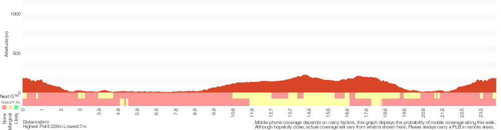
Analysis and summary of the altitude variation on the Dubbo Gully and Ten Mile Hollow Circuit (via Clares Bridge)
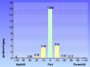
Daily actual walking time estimates
| Day | Walking Time | Length |
|---|---|---|
| 1 | 4 hrs 20 mins | 12.7 km |
| 2 | 4 hrs 32 mins | 11.8 km |
Overview of this walks grade – based on the AS 2156.1 – 2001
Under this standard, a walk is graded based on the most difficult section of the walk.
| Length | 24.3 km | ||
| Time | 2 Days | ||
| . | |||
| Grade 4/6 Hard track |
AS 2156.1 | Gradient | Very steep (4/6) |
| Quality of track | Formed track, with some branches and other obstacles (3/6) | ||
| Signs | Directional signs along the way (3/6) | ||
| Experience Required | Some bushwalking experience recommended (3/6) | ||
| Weather | Weather generally has little impact on safety (1/6) | ||
| Infrastructure | Limited facilities, not all cliffs are fenced (3/6) |
Some more details of this walks Grading
Here is a bit more details explaining grading looking at sections of the walk
Gradient
11km of this walk has short steep hills and another 9km has gentle hills with occasional steps. The remaining (3.9km) is very steep.
Quality of track
Around 23km of this walk follows a clear and well formed track or trail, whilst the remaining 1.2km follows a formed track, with some branches and other obstacles.
Signs
Around 18km of this walk has directional signs at most intersection, whilst the remaining 7km is clearly signposted.
Experience Required
Around 23km of this walk requires no previous bushwalking experience, whilst the remaining 1.2km requires some bushwalking experience.
weather
This whole walk, 24km is not usually affected by severe weather events (that would unexpectedly impact safety and navigation).
Infrastructure
Around 12km of this walk has limited facilities (such as not all cliffs fenced), whilst the remaining 12km is close to useful facilities (such as fenced cliffs and seats).
Similar walks
A list of walks that share part of the track with the Dubbo Gully and Ten Mile Hollow Circuit (via Clares Bridge) walk.
7.2 km Return
3 hrs 15 mins
Moderate track
27.3 km One way
2 Days
Hard track
28.3 km One way
2 Days
Moderate track
Other Nearby walks
A list of walks that start near the Dubbo Gully and Ten Mile Hollow Circuit (via Clares Bridge) walk.
11.2 km One way
4 hrs 30 mins
Hard track
15 km One way
5 hrs 30 mins
Hard track
8.3 km Return
3 hrs 15 mins
Moderate track
10.8 km Circuit
4 hrs 15 mins
Hard track
10.1 km Return
4 hrs 15 mins
Hard track
4.4 km Return
2 hrs
Hard track
5.6 km One way
2 hrs 45 mins
Hard track
8.1 km One way
3 hrs 30 mins
Hard track
17 km One way
6 hrs 30 mins
Hard track
33.7 km One way
2 Days
Hard track
11 km One way
3 hrs 30 mins
Easy track
6 km One way
2 hrs 30 mins
Hard track
Plan your trip to and from the walk here
The Dubbo Gully and Ten Mile Hollow Circuit (via Clares Bridge) walk starts and ends at the Dubbo Gully Rd car park (gps: -33.293017, 151.15119)
Your main transport option to Dubbo Gully Rd car park is by;
![]() Car. There is free parking available.
Car. There is free parking available.
(get details)
Short URL = http://wild.tl/dgatmhccb
Gallery images
There are other downloads I am still working on.
You will probably need to login to access these — still all free.
* KML (google earth file)
* GPX (GPS file)
Special Maps/ brochures
* A3 topo maps
* PDF with Lands Topo map base
* PDF with arial image (and map overlay)
I wanted to get the main site live first, this extra stuff will come in time.
Happy walking
Matt 🙂
Great North Road and Dubbo Gully
And Walk
Great North Road and Dubbo Gully

2 Days
27.3 km One way
1372 m
Hard track
This walk follows a section of the Old Great North Road along the borders of the rugged Yengo and Dharug National Parks, to then visit more historic sites in Dubbo Gully. This is more of a historic journey than you typical bushwalk. There is a campsite at Ten Mile Hollow providing a comfortable place for the night before visiting the Historic Clare’s Bridge. Soon after Clare’s Bridge this walk leaves the old Great North Road to follow Donny’s Track down into Dubbo gully were you get to explore this historic farming area before walking out to Upper Mangrove. This walk is mostly on wide trails and therefore can also be done as a mountain bike ride.
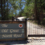
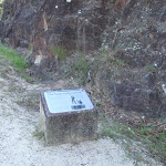

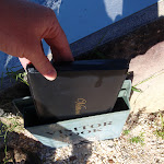


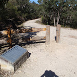

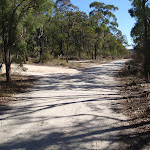
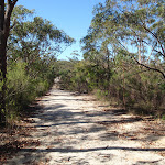

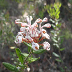

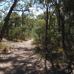
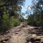
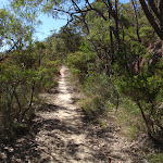

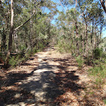
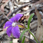
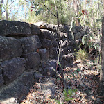
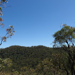
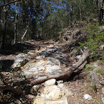


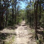
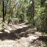
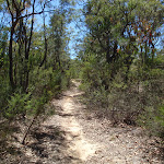
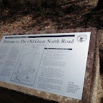
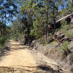
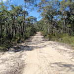
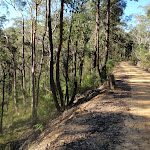
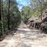

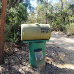

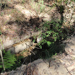

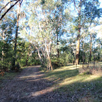
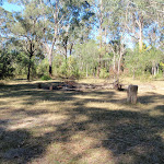

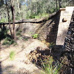
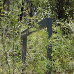

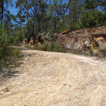
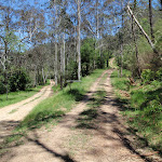

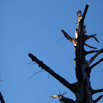
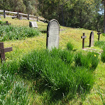

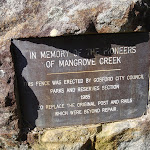


Old Great North Road
The historic Great North Road was built using convict labour between 1826 and 1836 (this section south of Wollombi was completed in 1832). The road formed a link between Sydney and the Hunter Valley, including Newcastle. There are visible remnants of the original work in bridges, retaining walls and other structures along the way. The ‘Convict Trail Project’ has member groups involved in the conservation of historical remnants along the road. The Convict Trail Project and the NPWS have erected information signs at various points to illustrate the history. The Convict Trail Project has an excellent website for further reading. More info.
(0km) Int of Wisemans Ferry Rd and OGNR → Hangmans Rock
1.1 km
31 mins
127m
-49m
Moderate track
From the car park and intersection on Wisemans Ferry Rd (about 500m west of the car ferry), the walk passes around a gate, passes an information sign, and follows the ‘Old Great North Road’ up the hill. This section of the walk winds up the hill, passing numerous cuttings and retaining walls built with convict labour. There are several information signs on the way, making the walk more interesting. The walk then arrives at the signposted “Hangman’s Rock”.
Hangmans Rock
Hangmans Rock is beside the historic Old Great North Road, near Wisemans Ferry, NSW. This beautiful sandstone cave/overhang has some steps and a bench seat cut into it and is part of the history of the convict built OGNR. It is uncertain what purpose the spot served, but stories that convicts were hanged through the hole in the roof of the cave appear unlikely to be true, despite giving a name to the atmospheric spot. More info.
(1.09km) Hangmans Rock → Int of OGNR and Shepherds Gully Rd
720 m
18 mins
69m
-12m
Moderate track
Continue straight: From Hangman’s Rock, the walk follows the management trail gently up the hill. The trail bends back and forth as it gently climbs. Another information sign indicates the probable site of a stockade to hold the “more troublesome convicts”. A little further along, the walk passes around a gate and reaches the intersection with “Shepherd’s Gully Road”. There is another information sign at this intersection.
Devines Hill
Devines Hill is a historically significant area on the Old Great North Road, near present day Wisemans Ferry, NSW. There are substantial remnants visible here, including cuttings, retaining walls and quarry sites. There were 3 main road lines built at different times to climb the hills just north of Wisemans Ferry, starting with Finchs Line to the east, followed by the Devines Hill ascent and then Shepherds Gully, to the west. Information signs in the area provide some interesting historical background and the ‘Convict Trail Project’ has an excellent website for further reading. More info.
(1.81km) Int of OGNR and Shepherds Gully Rd → Int of OGNR and Finchs Line
400 m
9 mins
25m
-4m
Moderate track
Veer right: From the intersection, the walk follows the ‘Finchs Line 500m’ arrow along the management trail, soon passing a culvert information display. The trail continues further up the gentle hill to reach the signposted intersection with the ‘Finchs Line’.
(2.2km) Int of OGNR and Finchs Line → Hair-pin bend
5.5 km
1 hr 57 mins
237m
-212m
Hard track
Continue straight: From the intersection, this walk follows the Old Great North Road east, gently uphill in the opposite direction to the ‘Devines Hill’ sign[1], keeping the valley to the left. The trail soon narrows a bit and meanders along the top of the ridge, bending left to head north east. The trail continues to wind along the top of the ridge until about 180m passed a rock platform (above and to the left of the old road) the trail comes to a three way intersection with the 3 Mile Trail (on the left).
Continue straight: From the intersection, this walk follows the old Great North Road east, initially keeping the valley to the right as the trail narrows significantly. The trail bends around a spur then widens and narrows a few times before crossing a flat rock platform 600m from 3 Mile trail. About 300m past the rock platform the trail bears right (ignoring the faint trail to the left, marked with a square boulder) and winds around the side of the hill for just shy of 400m to come to the other end of the same faint trail (overgrown on the left). Here the rocky trail heads up the hill to come to soon come to a large clearing. On the other side of the clearing the trail narrows again and cross a few particularly narrow saddles to then head down another short and fairly steep rocky section of trail just after a right hand bend. Here the trail narrows again and is fairly flat for about 400m will valley views to the left. The trail then bends right and heads down hill coming to a distinct left hand hair-pin bend part way down the hill.
Continue straight: From the intersection, this walk follows the old Great North Road east, initially keeping the valley to the right as the trail narrows significantly. The trail bends around a spur then widens and narrows a few times before crossing a flat rock platform 600m from 3 Mile trail. About 300m past the rock platform the trail bears right (ignoring the faint trail to the left, marked with a square boulder) and winds around the side of the hill for just shy of 400m to come to the other end of the same faint trail (overgrown on the left). Here the rocky trail heads up the hill to come to soon come to a large clearing. On the other side of the clearing the trail narrows again and cross a few particularly narrow saddles to then head down another short and fairly steep rocky section of trail just after a right hand bend. Here the trail narrows again and is fairly flat for about 400m will valley views to the left. The trail then bends right and heads down hill coming to a distinct left hand hair-pin bend part way down the hill.
(7.71km) Hair-pin bend → Int of WCT and OGNR
4.1 km
1 hr 31 mins
215m
-168m
Hard track
Turn left: From the bend, this walk heads downhill along the Old Great North Road initially keeping the valley to the right. As the trail rounds the gully it starts to climb and heads alongside a wire fence marking a short re-vegetation detour that crosses over the ridge. Now with the valley on the left the trail works its way along the side of the hill as it widens and narrows a few times, as well as passing a couple of short rocky section. About 1km from the end of the detour, the trail comes up to a pair-pin bend (up to the right, with some nice valley views to the left). Here the walk follows the old road around the sharp bend and up the hill. Now with the valley on the right, the narrow trail winds through the tall trees along the ridge and soon after crossing a wide saddle to the other side of the ridge the trail comes to a ‘Dharug National Park No Camping or Fires’ sign[2]. From this sign the trail continues up along the ridge for about 1km passing a few rocky sections, (and a faint trail to the right) to come to clearly signposted intersection with ‘Western Commission trail’ on the right. There is also ‘Welcome to The Old Great North Road’ information sign[3].
(11.77km) Int of WCT and OGNR → Eastern end of Eight Mile Trail
1.1 km
21 mins
27m
-35m
Moderate track
Veer left: From the intersection, this walk follows the ‘Old Great North Rd’ arrow east, downhill along the clear trail. The trail meanders for a while, passing some lovely rock formations and some old road guttering. The walk then comes to an intersection with a clear but unsignposted management trail (on the left).
(12.85km) Eastern end of Eight Mile Trail → Southern end of the Wat Trail
780 m
16 mins
25m
-41m
Moderate track
Continue straight: From the intersection, this walk follows the OGNR as it head downhill, bending to the right (keeping the valley on the right). Soon, there are some nice views to the left and the trail heads uphill. Near the top of the hill, this walk ignores the ‘144-147’ trail (on the right) and heads across the sandstone cutting. As the trail bends around the gully, there are some cuttings in the rock on the right. Where the trail bends sharply right, there is an intersection with the gated Wat track (on the left).
(13.63km) Southern end of the Wat Trail → Wat Buddha Dhamma
1.3 km
25 mins
17m
-84m
Moderate track
Veer right: From the intersection, this walk follows the OGNR trail downhill, following the ‘142.3’ sign (keeping the valley on the left). The trail levels out as it passes a ‘Severe Bends’ sign, facing the other way. About 200m past this sign, the walk comes to a ‘Drinking Water’ tank and the ‘Wat Buddha Dhamma’ Monastery.
Wat Buddha Dhamma
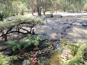
The Wat Buddha Dhamma is a Monastery about 600m south of Ten Mile Hollow Campsite, on the Old Great North Road. The Monks provides a water tank and toilet for people passing by. The monks welcome guests and requests that visitors dress modestly (no shorts or revealing clothing), and that visitors are encouraged to share in the life with the monks. More info.
(14.94km) Wat Buddha Dhamma → Ten Mile Hollow
620 m
11 mins
2m
-23m
Easy track
Continue straight: From the ‘Drinking Water’ tank, this walk heads north east along the OGNR, initially keeping the monastery to the left. Soon the trail passes a couple of other driveways for the monastery and heads past a small pine plantation (on the left). Before long, the trail leads to a ‘Y’ intersection with the ‘Simpson Track’ at the ‘Ten Mile Hollow’ campground.
Ten Mile Hollow
This large, open campsite is found next to the Old Great North Road, at the top of the Simpson Track. The campsite is great for people walking or cycling in the area. There is fairly new hybrid toilet, a few fire circles and plenty of places to pitch some tents. There is a water tank next to the toilet – if this is empty, there is sometimes water in Ten Mile Hollow creek a short distance north along the OGNR (otherwise the Wat Buddha Dhamma, about 600m south along the OGNR, provide a water tank for visitors). Treat water before drinking.
The area was formally a stockade (a camp) for the convicts who built the road in c.1830. Later the area was named ‘Snodgrass Valley’ and plans to build a town were developed, neither the name nor the town proved popular (even at 2 pounds an acre). Solomon Wiseman (of Wisemans Ferry fame) was given 100 acres to build an inn, however it is not clear if the inn was ever built. More info.
The area was formally a stockade (a camp) for the convicts who built the road in c.1830. Later the area was named ‘Snodgrass Valley’ and plans to build a town were developed, neither the name nor the town proved popular (even at 2 pounds an acre). Solomon Wiseman (of Wisemans Ferry fame) was given 100 acres to build an inn, however it is not clear if the inn was ever built. More info.
End of day 1
This is the planned overnight stay for the end of day 1, happy camping.
(15.55km) Ten Mile Hollow → Clares Bridge
1.2 km
22 mins
33m
-6m
Moderate track
Veer left: From Ten Mile Hollow, this walk follows the ‘Clares Bridge’ sign[5] along the OGNR, as it soon bends to the left. The trail narrows and comes to an old bridge (with a timber base). The walk crosses the bridge (and Ten Mile Hollow Creek) and heads around the gate. The walk follows the overgrown management trail through the bush for a while, coming to a white wooden barricade. Heading around the barricade, the walk comes to a clearing and signpost just before Clare’s Bridge[6].
Clares Bridge
Clare’s Bridge, on the Old Great North Road, is about 1km north of Ten Mile Hollow camping area. This, and a number of other bridges, were built during the construction of the old road. Clare’s Bridge is the most visually spectacular of the bridges. The second oldest bridge on mainland Australia (The oldest being Thomas James Bridge), it is built of sandstone blocks and has a wonderful, sweeping retaining wall. The sweeping design gives full view of the craftsmanship to those passing by. Much work has been done by NPWS and Gosford Council to restore the bridge. There is no deck on the bridge, however it is still an impressive structure and a fascinating piece of history. More info.
(16.76km) Clares Bridge → Int of the OGNR and Donnys track
790 m
21 mins
75m
-27m
Moderate track
Continue straight: From the ‘Clare’s Bridge’ information sign[7], this walk follows the track down to cross the gully, keeping Clare’s Bridge to the right. On the other side of the gully, the track rises to meet the management trail again. The walk continues along the OGNR up the hill, away from the old bridge. The track winds around the hill and comes to an intersection with the Wat track (on the left, signposted with ‘125,126 142-168’).
Continue straight: From the intersection, this walk follows the OGNR up the gentle hill, keeping the valley to the right. Soon, the trail leads to a large clearing and four-way intersection, with a sign pointing back to ‘Clare’s Bridge’[8].
Continue straight: From the intersection, this walk follows the OGNR up the gentle hill, keeping the valley to the right. Soon, the trail leads to a large clearing and four-way intersection, with a sign pointing back to ‘Clare’s Bridge’[8].
(17.56km) Int of the OGNR and Donny’s track → Donny’s View
3.9 km
1 hr 27 mins
136m
-217m
Hard track
Continue straight: From the intersection, this walk follows the ‘Donny’s Track’ sign[9] along the only trail that heads steeply downhill. The trail soon bends right and starts to flatten out, then after a left-bend, the trail straightens out for about 700m. Soon after passing an overgrown trail (on the right), the main trail bends left and crosses a wide gully and often-dry creek. The trail then bends right and starts to wind up the hill, passing a few cuttings. About 300m after passing under the power lines, the trail comes to an intersection with the signposted ‘138 137’ track (on the left) and a view to the power lines. Here, the main trail bends right and continues uphill more gently. Soon, the trail crosses a saddle and starts to head down the other side of the ridge. The trail then heads down through a sharp left then right bends, then comes to another right-hand bend and an unfenced rock platform with views into the valley, Donny’s view.
Donny’s View
Donny’s View is an informally named vantage point partway up Donny’s Track. The unfenced rock slabs provide a view over Chaselings Run valley and swamp, down to the old Ten Mile Hollow Road. Found on the bendy section of the management trail, this view provides a good excuse to stop and take a break. To the north is a view of the high tension power lines that span this section of the park
(21.44km) Donny’s View → Int of Ten Mile Hollow Rd and Donny’s track
1.5 km
43 mins
53m
-170m
Moderate track
Continue straight: From Donny’s view, this walk follows the old road down the hill, keeping the filtered views of ‘Chaselings Run’ to the left. The trail passes the base of some high-cut cliffs (on the right) and some rusty guard rails and soon comes to a locked gate. The walk passes around the locked gate and the ‘Dharug National Park’ sign[10], then follows a rusty guard rail to a right-hand bend. The trail then winds down the hill and, soon after passing between two old fence posts, the trail bends sharply left and passes to two more old gate posts. The trail then gently winds down the hill and comes to an intersection with the old Ten Mile Hollow Road and a sign pointing back up ‘Donny’s Track’[11].
(22.98km) Int of Ten Mile Hollow Rd and Donnys track → Fairview Homestead
930 m
18 mins
29m
-24m
Moderate track
Turn sharp right: From the intersection, the walk follows the management trail down the hill. The walk soon passes around a gate and continues a little further, passing around a swampy area to the left and immediately arriving at an intersection near a gate. The trail behind the gate leads to an old abandoned house and shed, which could provide some shelter.
Continue straight: From the intersection, the walk passes around the gate and follows the management trail steeply up the hill. The trail soon arrives at an old, abandoned house. At the end of this side trip, retrace your steps back to the main walk then Continue straight.
Continue straight: From the intersection, the walk passes around the gate and follows the management trail steeply up the hill. The trail soon arrives at an old, abandoned house. At the end of this side trip, retrace your steps back to the main walk then Continue straight.
Fairview
Fairview (550 Ten Mile Hollow Rd, Mangrove Creek) is a property with a homestead, built in 1922 by Alfred Andrews. The homestead and adjoining slab hut are now fenced to protect them, however the large corrugated iron shed on the south side is still open. The homestead was once a popular rest area for people traveling the North Road, via the Simpson track. The home was privately owned until 1973 when Gosford City Council acquired the land to protect the catchment area. The home was rented until 2002, when the tenants moved due to the threat of bushfires. The building is now in poor condition and the ‘Friends of Fairview’ are exploring ways to save the building and restore the history of the valley. Save Fairview More info.
(22.98km) Int of Ten Mile Hollow Rd and Donnys track → Upper Mangrove cemetery
740 m
15 mins
21m
-27m
Moderate track
Veer left: From the intersection, the walk follows the management trail up the hill. After a short distance, the walk passes a large grassy clearing to the right and a swampy area to the left. The trail meanders along the valley for some time before arriving at a historic cemetery, on the right.
Upper Mangrove Cemetery
The Upper Mangrove Cemetery is on the western bank of Mangrove Creek, near the junction with Newmans Creek. The cemetery was part of St Thomas’ Church of England, however the church building was destroyed in the 2002 bushfires. Exploring the cemetery gives a glimpse into the history of the valley. You will find the stone remembering Alfred and Amanda Andrews who built ‘Fairview’ in 1922 and read of the loss of Leslie Starkey’s parents in 1913. On the other side of the road, up the hill, is the remains of of the old St Thomas’ Church building[13]. More info.
(23.72km) Upper Mangrove cemetery → Int of Dubbo Gully Rd and Upper Mangrove Creek Rd
1.1 km
22 mins
33m
-36m
Moderate track
Continue straight: From the cemetery, the walk follows the management trail (Ten Mile Hollow Rd) up the hill, leaving the cemetery on the right, and soon passes under some high voltage power lines. The walk then meanders along the road for some time, passing some old orange trees on the right and an old ‘134’ sign on the left. Some distance later, the walk crosses an old timber bridge and arrives at the signposted intersection with the ‘Upper Mangrove Creek Rd’ (with a shorter bridge to the left).
(24.83km) Int of Dubbo Gully Rd and Upper Mangrove Creek Rd → Dubbo Gully Rd car park
2.5 km
1 hr 2 mins
277m
-104m
Moderate track
Continue straight: From the intersection, the walk follows the management trail up the hill (now Dubbo Gully Rd). The trail winds up the hill for a long while through some beautiful scenery, including some great rock formations and overhangs. The walk then passes around a gate and continues a little further up the hill to reach a small car park on the left (on Dubbo Gully Rd, a short distance off Waratah Rd, about 4km west of Mangrove Mountain).
Maps for the Great North Road and Dubbo Gully walk
You can download the PDF for this walk to print a map.
These maps below cover the walk and the wider area around the walk, they are worth carrying for safety reasons.
| Mangrove | 1:25 000 Map Series | 91313N MANGROVE | NSW-91313N |
| Lower Portland | 1:25 000 Map Series | 90312S LOWER PORTLAND | NSW-90312S |
| St Albans | 1:25 000 Map Series | 90312N ST ALBANS | NSW-90312N |
| Gosford | 1:100 000 Map Series | 9131 GOSFORD | 9131 |
| St Albans | 1:100 000 Map Series | 9031 ST ALBANS | 9031 |
Cross sectional view of the Great North Road and Dubbo Gully bushwalking track
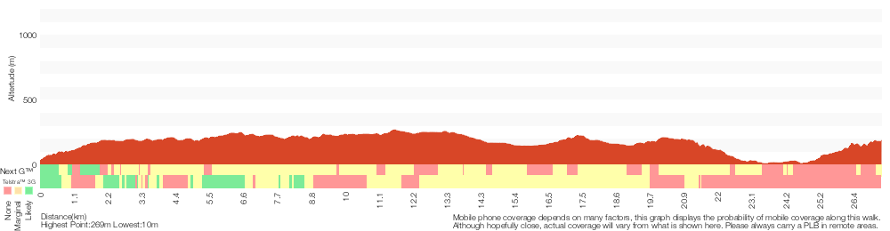
Analysis and summary of the altitude variation on the Great North Road and Dubbo Gully
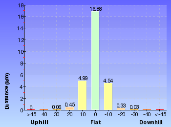
Daily actual walking time estimates
| Day | Walking Time | Length |
|---|---|---|
| 1 | 5 hrs 39 mins | 15.6 km |
| 2 | 4 hrs 50 mins | 12.7 km |
Overview of this walks grade – based on the AS 2156.1 – 2001
Under this standard, a walk is graded based on the most difficult section of the walk.
| Length | 27.3 km | ||
| Time | 2 Days | ||
| . | |||
| Grade 4/6 Hard track |
AS 2156.1 | Gradient | Very steep (4/6) |
| Quality of track | Formed track, with some branches and other obstacles (3/6) | ||
| Signs | Minimal directional signs (4/6) | ||
| Experience Required | Moderate level of bushwalking experience recommended (4/6) | ||
| Weather | Weather generally has little impact on safety (1/6) | ||
| Infrastructure | Limited facilities, not all cliffs are fenced (3/6) |
Some more details of this walks Grading
Here is a bit more details explaining grading looking at sections of the walk
Gradient
15km of this walk has short steep hills and another 8km has gentle hills with occasional steps. The remaining (3.9km) is very steep.
Quality of track
Around 18km of this walk follows a clear and well formed track or trail, whilst the remaining 9km follows a formed track, with some branches and other obstacles.
Signs
12km of this walk has directional signs at most intersection and another 10km has minimal directional signs. The remaining (6km) is clearly signposted.
Experience Required
15km of this walk requires no previous bushwalking experience and another 10km requires a leader a with moderate level of bushwalking experience. The remaining (2.3km) requires some bushwalking experience.
weather
This whole walk, 27km is not usually affected by severe weather events (that would unexpectedly impact safety and navigation).
Infrastructure
Around 16km of this walk has limited facilities (such as not all cliffs fenced), whilst the remaining 12km is close to useful facilities (such as fenced cliffs and seats).
Similar walks
A list of walks that share part of the track with the Great North Road and Dubbo Gully walk.
2.2 km Return
1 hr 15 mins
Moderate track
3.6 km Return
2 hrs
Moderate track
4 km One way
2 hrs
Moderate track
4.3 km Return
2 hrs
Moderate track
7.2 km Return
3 hrs 15 mins
Moderate track
9.9 km Circuit
4 hrs 30 mins
Moderate track
24.3 km Circuit
2 Days
Hard track
28.3 km One way
2 Days
Moderate track
Other Nearby walks
A list of walks that start near the Great North Road and Dubbo Gully walk.
4.4 km Return
2 hrs 15 mins
Moderate track
8.2 km Circuit
4 hrs 15 mins
Hard track
4.5 km Return
2 hrs 15 mins
Hard track
1.7 km Circuit
1 Hr
Moderate track
8.3 km Return
3 hrs 15 mins
Moderate track
10.8 km Circuit
4 hrs 15 mins
Hard track
10.1 km Return
4 hrs 15 mins
Hard track
4.4 km Return
2 hrs
Hard track
426 m Return
20 mins
Moderate track
6 km One way
2 hrs 30 mins
Hard track
21.1 km One way
8 hrs
Hard track
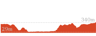
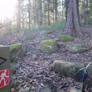
47.4 km One way
3 Days
Hard track
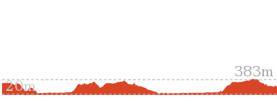
Plan your trip to and from the walk here
The Great North Road and Dubbo Gully walk starts at the Int of Wisemans Ferry Rd and OGNR (gps: -33.375218, 150.98486)
Your transport options to Int of Wisemans Ferry Rd and OGNR are by;
![]() Bus. Wisemans Ferry Dialacar provides a taxi style mini-bus service based in Wisemans Ferry. The cost is typically about per km (ex Wisemans Ferry). They will pick-up and drop-off from Sydney or the Central Coast and will happily drop walkers off or pick them up from tracks in the area. The cost for a pick-up from Gosford and drop off near Wisemans Ferry would be approximately 0 (please call for up-to-date pricing) and the minivan can carry up to 13 passengers. Phone: 0448 122 374 (get details)
Bus. Wisemans Ferry Dialacar provides a taxi style mini-bus service based in Wisemans Ferry. The cost is typically about per km (ex Wisemans Ferry). They will pick-up and drop-off from Sydney or the Central Coast and will happily drop walkers off or pick them up from tracks in the area. The cost for a pick-up from Gosford and drop off near Wisemans Ferry would be approximately 0 (please call for up-to-date pricing) and the minivan can carry up to 13 passengers. Phone: 0448 122 374 (get details)
![]() Car. There is free parking available.
Car. There is free parking available.
(get details)
The Great North Road and Dubbo Gully ends at the Dubbo Gully Rd car park (gps: -33.293017, 151.15119)
Your main transport option to Dubbo Gully Rd car park is by;
![]() Car. There is free parking available.
Car. There is free parking available.
(get details)
Short URL = http://wild.tl/gnradg
Gallery images
There are other downloads I am still working on.
You will probably need to login to access these — still all free.
* KML (google earth file)
* GPX (GPS file)
Special Maps/ brochures
* A3 topo maps
* PDF with Lands Topo map base
* PDF with arial image (and map overlay)
I wanted to get the main site live first, this extra stuff will come in time.
Happy walking
Matt 🙂
Western Commission Track to Dubbo Gully

2 Days
28.3 km One way
1249 m
Moderate track
This two day walk follows a series of historic roads along clear and wide management trails. This walk explores the great views from Western Commission Track, the sandstone handicraft on the Old Great North Road and the farming history of Ten Mile Hollow, and also offers a side trip to Clare’s Bridge. Camping at the well-established Ten Mile Hollow campsite, this walk is great for those who enjoy walking on trails, visiting convict sites and early settlement historic places.
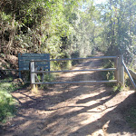
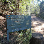
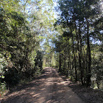
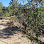
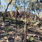
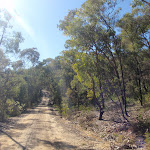

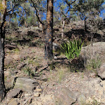


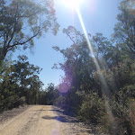
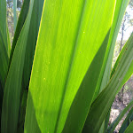
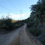
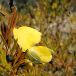
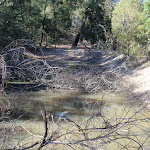

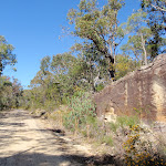
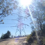
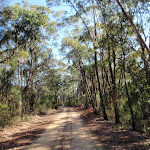

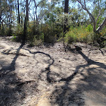
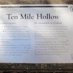

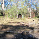
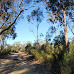

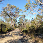
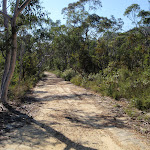
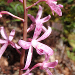

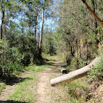
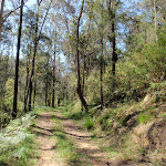
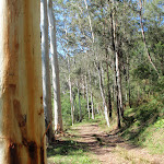
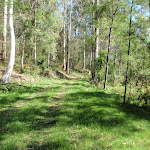
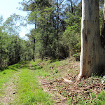
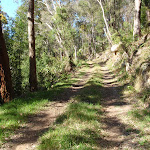
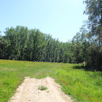

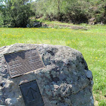
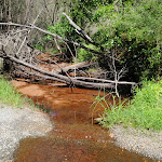
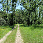
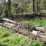


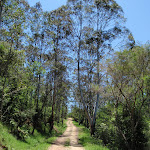
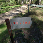
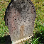

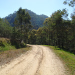
(0km) Bottom end of Western Commission Track → Dam
4.4 km
1 hr 45 mins
318m
-130m
Moderate track
From the intersection of the Western Commission Track and Wisemans Ferry Rd (3.6km west of Wisemans Ferry), this walk heads up the management trail following the ‘W.B.D’ sign away from ‘Willow Glen’. The walk soon heads around a locked gate and past the ‘Dharug National Park’ sign. As the trail starts to steepen it passes a ‘Severe Bends’ road sign, and winds up the hill. The trail then bends left, passes under the powerlines and comes to an old management trail on the left, signposted ‘168-167’
Continue straight: From the intersection, this walk follows the main management trail up the hill, keeping the valley to the right. After about 400m the trail passes between two small old dams. About another 800 meters on the trail bends sharply to the right, where there are good views across the valley on the left. Further up the hill the trail passes the 165-166 trail on the right. The trail now flattens out and passes 4 high tension electrical tower, with filtered distant views. Soon after the 4th tower the trail leads to a large clearing and dam on the right.
Continue straight: From the intersection, this walk follows the main management trail up the hill, keeping the valley to the right. After about 400m the trail passes between two small old dams. About another 800 meters on the trail bends sharply to the right, where there are good views across the valley on the left. Further up the hill the trail passes the 165-166 trail on the right. The trail now flattens out and passes 4 high tension electrical tower, with filtered distant views. Soon after the 4th tower the trail leads to a large clearing and dam on the right.
Western Commission track Dam
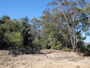
This large clearing is about two thirds the way up Western Commission track. The is a fairly large dam and what seems to be an old quarry for building the road. The dam is not a reliable source of water (and very questionable quality). There is a shady section behind the dam that seems to be an old campsite, and a good place to rest.
(4.44km) Dam → Int of WCT and OGNR
7.5 km
2 hrs 39 mins
332m
-269m
Moderate track
Continue straight: From the clearing, this walk follows the management trail up the hill, away from the electricity tower, keeping the valley to the left. The trail soon passes the ‘160’ trail and gently winds around a bit further to pass the ‘168-159’ trail. The walk follows the main trail then winds through a pleasant gully with interesting rock formation and a moister, cooler forest. The trail then passes the other end of the ‘168-159’ trail (on the left) and comes to the electrical tower on the sharp right-hand bend. The trail continues along the ridge, passing the ‘151-153’ trail on the left, then coming to another electricity tower just to the left of the trail. About 300m past this tower, the trail leads between the posts of an old gate with a fence made from train tracks. Another 300m further along, the trail comes to the intersection with the Old Great North Road (there are a number of signs and information about the OGNR).
(11.94km) Int of WCT and OGNR → Southern end of the Wat Trail
1.9 km
37 mins
52m
-76m
Moderate track
Veer right: From the intersection, this walk follows the ‘Old Great North Rd’ arrow east, downhill along the clear trail. The trail meanders for a while, passing some lovely rock formations and some old road guttering. The walk then comes to an intersection with a clear but unsignposted management trail (on the left).
Continue straight: From the intersection, this walk follows the OGNR as it head downhill, bending to the right (keeping the valley on the right). Soon, there are some nice views to the left and the trail heads uphill. Near the top of the hill, this walk ignores the ‘144-147’ trail (on the right) and heads across the sandstone cutting. As the trail bends around the gully, there are some cuttings in the rock on the right. Where the trail bends sharply right, there is an intersection with the gated Wat track (on the left).
Continue straight: From the intersection, this walk follows the OGNR as it head downhill, bending to the right (keeping the valley on the right). Soon, there are some nice views to the left and the trail heads uphill. Near the top of the hill, this walk ignores the ‘144-147’ trail (on the right) and heads across the sandstone cutting. As the trail bends around the gully, there are some cuttings in the rock on the right. Where the trail bends sharply right, there is an intersection with the gated Wat track (on the left).
(13.81km) Southern end of the Wat Trail → Wat Buddha Dhamma
1.3 km
25 mins
17m
-84m
Moderate track
Veer right: From the intersection, this walk follows the OGNR trail downhill, following the ‘142.3’ sign (keeping the valley on the left). The trail levels out as it passes a ‘Severe Bends’ sign, facing the other way. About 200m past this sign, the walk comes to a ‘Drinking Water’ tank and the ‘Wat Buddha Dhamma’ Monastery.
Wat Buddha Dhamma
The Wat Buddha Dhamma is a Monastery about 600m south of Ten Mile Hollow Campsite, on the Old Great North Road. The Monks provides a water tank and toilet for people passing by. The monks welcome guests and requests that visitors dress modestly (no shorts or revealing clothing), and that visitors are encouraged to share in the life with the monks. More info.
(15.11km) Wat Buddha Dhamma → Ten Mile Hollow
620 m
11 mins
2m
-23m
Easy track
Continue straight: From the ‘Drinking Water’ tank, this walk heads north east along the OGNR, initially keeping the monastery to the left. Soon the trail passes a couple of other driveways for the monastery and heads past a small pine plantation (on the left). Before long, the trail leads to a ‘Y’ intersection with the ‘Simpson Track’ at the ‘Ten Mile Hollow’ campground.
Ten Mile Hollow
This large, open campsite is found next to the Old Great North Road, at the top of the Simpson Track. The campsite is great for people walking or cycling in the area. There is fairly new hybrid toilet, a few fire circles and plenty of places to pitch some tents. There is a water tank next to the toilet – if this is empty, there is sometimes water in Ten Mile Hollow creek a short distance north along the OGNR (otherwise the Wat Buddha Dhamma, about 600m south along the OGNR, provide a water tank for visitors). Treat water before drinking.
The area was formally a stockade (a camp) for the convicts who built the road in c.1830. Later the area was named ‘Snodgrass Valley’ and plans to build a town were developed, neither the name nor the town proved popular (even at 2 pounds an acre). Solomon Wiseman (of Wisemans Ferry fame) was given 100 acres to build an inn, however it is not clear if the inn was ever built. More info.
The area was formally a stockade (a camp) for the convicts who built the road in c.1830. Later the area was named ‘Snodgrass Valley’ and plans to build a town were developed, neither the name nor the town proved popular (even at 2 pounds an acre). Solomon Wiseman (of Wisemans Ferry fame) was given 100 acres to build an inn, however it is not clear if the inn was ever built. More info.
(15.73km) Ten Mile Hollow → Clares Bridge
1.2 km
22 mins
33m
-6m
Moderate track
Veer left: From Ten Mile Hollow, this walk follows the ‘Clares Bridge’ sign[2] along the OGNR, as it soon bends to the left. The trail narrows and comes to an old bridge (with a timber base). The walk crosses the bridge (and Ten Mile Hollow Creek) and heads around the gate. The walk follows the overgrown management trail through the bush for a while, coming to a white wooden barricade. Heading around the barricade, the walk comes to a clearing and signpost just before Clare’s Bridge[3]. At the end of this side trip, retrace your steps back to the main walk then Turn left.
Clares Bridge
Clare’s Bridge, on the Old Great North Road, is about 1km north of Ten Mile Hollow camping area. This, and a number of other bridges, were built during the construction of the old road. Clare’s Bridge is the most visually spectacular of the bridges. The second oldest bridge on mainland Australia (The oldest being Thomas James Bridge), it is built of sandstone blocks and has a wonderful, sweeping retaining wall. The sweeping design gives full view of the craftsmanship to those passing by. Much work has been done by NPWS and Gosford Council to restore the bridge. There is no deck on the bridge, however it is still an impressive structure and a fascinating piece of history. More info.
End of day 1
This is the planned overnight stay for the end of day 1, happy camping.
(15.73km) Ten Mile Hollow → Simpsons Cave
2.5 km
47 mins
39m
-108m
Moderate track
Veer right: From the intersection, this walk follows the ‘Simpsons Track’ sign[4] along the management trail, initially keeping the Ten Mile Hollow campsite immediately on the right. The trail passes through an old (open) gate then bends right, then comes to a large clearing and passes under the high-tension power lines. The walk continues down along the management trail as the gully on the left becomes steeper. About 50m after passing a large boulder (on the left-hand side of the trail, at a right-hand bend), the trail comes into view of a couple of sandstone caves, about 10m up the cliff to the right.
Simpsons Cave
Simpsons Cave is an informal name given to a sandstone overhang on the Simpson Track, about 2.5km east of the junction with the Old Great North Road. The cave is perched high on the side of the old road and looks north over Ten Mile Hollow valley. The cave has an outward sloping floor and is best viewed from the track.
(18.23km) Simpsons Cave → Int of Ten Mile Hollow Rd and Simpsons track
2.4 km
49 mins
70m
-135m
Moderate track
Continue straight: From the cave, this walk follows the management trail (Simpsons Track) downhill, keeping the valley to the left. As the trail winds down the hill, there is a distinct change in vegetation and, about 750m from the caves, the trail crosses a small creek and leaves the signposted ‘Dharug National Park’. The walk continues down the hill and after another 500m, the trail crosses another small creek and passes through a series of flat grassy clearings. The trail then meanders along the flat for a while, leaving the clearings and soon coming to a larger grassy clearing and intersection. There are two large boulders here, with plaques about the ‘Convict Trail’ project.
(20.6km) Int of Ten Mile Hollow Rd and Simpsons track → Int below Fairview Homestead
2.5 km
47 mins
66m
-60m
Moderate track
Turn left: From the intersection, the walk follows the management trail (Ten Mile Hollow Rd) away from the National Parks walkers signpost[5], passing a couple of small boulders, with a visitors book and ‘Convict Trail’ information signs[6][7], on the right. The trail soon crosses a creek and passes into a long clearing with the remains of an old wooden fenced cattle yard. From here, the walk passes a smaller clearing, to the right, with a padlocked steel ‘Monitoring Well’, then meanders for some time close to the creek, passing through some nice trees and some large clearings. The walk then passes a ‘Heritage Road Wall AND Culvert Protection’ signpost[8]. Allow some time to look at the old road retaining wall sections along here. A little further along, the trail bends to the left and arrives at an intersection with a gate to the left. The trail behind the gate leads to an old abandoned house and shed, which could provide some shelter.
(23.15km) Int below Fairview Homestead → Fairview Homestead
120 m
3 mins
10m
-2m
Moderate track
Turn left: From the intersection, the walk passes around the gate and follows the management trail steeply up the hill. The trail soon arrives at an old, abandoned house. At the end of this side trip, retrace your steps back to the main walk then Continue straight.
Fairview
Fairview (550 Ten Mile Hollow Rd, Mangrove Creek) is a property with a homestead, built in 1922 by Alfred Andrews. The homestead and adjoining slab hut are now fenced to protect them, however the large corrugated iron shed on the south side is still open. The homestead was once a popular rest area for people traveling the North Road, via the Simpson track. The home was privately owned until 1973 when Gosford City Council acquired the land to protect the catchment area. The home was rented until 2002, when the tenants moved due to the threat of bushfires. The building is now in poor condition and the ‘Friends of Fairview’ are exploring ways to save the building and restore the history of the valley. Save Fairview More info.
(23.15km) Int below Fairview Homestead → Int of Ten Mile Hollow Rd and Donnys track
810 m
15 mins
22m
-19m
Moderate track
Turn right: From the intersection, the walk follows the management trail away from the gate, keeping the swampy area to the right. The walk continues for a while before passing around a gate and soon arrives at the signposted intersection with ‘Donny’s Track’[9].
(23.95km) Int of Ten Mile Hollow Rd and Donnys track → Upper Mangrove cemetery
740 m
15 mins
21m
-27m
Moderate track
Continue straight: From the intersection, the walk follows the management trail up the hill. After a short distance, the walk passes a large grassy clearing to the right and a swampy area to the left. The trail meanders along the valley for some time before arriving at a historic cemetery, on the right.
Upper Mangrove Cemetery
The Upper Mangrove Cemetery is on the western bank of Mangrove Creek, near the junction with Newmans Creek. The cemetery was part of St Thomas’ Church of England, however the church building was destroyed in the 2002 bushfires. Exploring the cemetery gives a glimpse into the history of the valley. You will find the stone remembering Alfred and Amanda Andrews who built ‘Fairview’ in 1922 and read of the loss of Leslie Starkey’s parents in 1913. On the other side of the road, up the hill, is the remains of of the old St Thomas’ Church building[11]. More info.
(24.7km) Upper Mangrove cemetery → Int of Dubbo Gully Rd and Upper Mangrove Creek Rd
1.1 km
22 mins
33m
-36m
Moderate track
Continue straight: From the cemetery, the walk follows the management trail (Ten Mile Hollow Rd) up the hill, leaving the cemetery on the right, and soon passes under some high voltage power lines. The walk then meanders along the road for some time, passing some old orange trees on the right and an old ‘134’ sign on the left. Some distance later, the walk crosses an old timber bridge and arrives at the signposted intersection with the ‘Upper Mangrove Creek Rd’ (with a shorter bridge to the left).
(25.81km) Int of Dubbo Gully Rd and Upper Mangrove Creek Rd → Dubbo Gully Rd car park
2.5 km
1 hr 2 mins
277m
-104m
Moderate track
Continue straight: From the intersection, the walk follows the management trail up the hill (now Dubbo Gully Rd). The trail winds up the hill for a long while through some beautiful scenery, including some great rock formations and overhangs. The walk then passes around a gate and continues a little further up the hill to reach a small car park on the left (on Dubbo Gully Rd, a short distance off Waratah Rd, about 4km west of Mangrove Mountain).
Maps for the Western Commission Track to Dubbo Gully walk
You can download the PDF for this walk to print a map.
These maps below cover the walk and the wider area around the walk, they are worth carrying for safety reasons.
| Gunderman | 1:25 000 Map Series | 91313S GUNDERMAN | NSW-91313S |
| Mangrove | 1:25 000 Map Series | 91313N MANGROVE | NSW-91313N |
| Gosford | 1:100 000 Map Series | 9131 GOSFORD | 9131 |
Cross sectional view of the Western Commission Track to Dubbo Gully bushwalking track
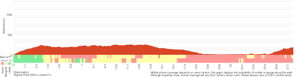
Analysis and summary of the altitude variation on the Western Commission Track to Dubbo Gully
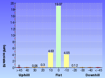
Daily actual walking time estimates
| Day | Walking Time | Length |
|---|---|---|
| 1 | 5 hrs 59 mins | 16.9 km |
| 2 | 4 hrs 20 mins | 12.7 km |
Overview of this walks grade – based on the AS 2156.1 – 2001
Under this standard, a walk is graded based on the most difficult section of the walk.
| Length | 28.3 km | ||
| Time | 2 Days | ||
| . | |||
| Grade 3/6 Moderate track |
AS 2156.1 | Gradient | Short steep hills (3/6) |
| Quality of track | Clear and well formed track or trail (2/6) | ||
| Signs | Directional signs along the way (3/6) | ||
| Experience Required | Some bushwalking experience recommended (3/6) | ||
| Weather | Weather generally has little impact on safety (1/6) | ||
| Infrastructure | Limited facilities, not all cliffs are fenced (3/6) |
Some more details of this walks Grading
Here is a bit more details explaining grading looking at sections of the walk
Gradient
Around 16km of this walk has gentle hills with occasional steps, whilst the remaining 12km has short steep hills.
Quality of track
This whole walk, 28km follows a clear and well formed track or trail.
Signs
Around 24km of this walk has directional signs at most intersection, whilst the remaining 4.3km is clearly signposted.
Experience Required
Around 16km of this walk requires no previous bushwalking experience, whilst the remaining 12km requires some bushwalking experience.
weather
This whole walk, 28km is not usually affected by severe weather events (that would unexpectedly impact safety and navigation).
Infrastructure
Around 21km of this walk has limited facilities (such as not all cliffs fenced), whilst the remaining 8km is close to useful facilities (such as fenced cliffs and seats).
Similar walks
A list of walks that share part of the track with the Western Commission Track to Dubbo Gully walk.
7.2 km Return
3 hrs 15 mins
Moderate track
24.3 km Circuit
2 Days
Hard track
27.3 km One way
2 Days
Hard track
Other Nearby walks
A list of walks that start near the Western Commission Track to Dubbo Gully walk.
4.4 km Return
2 hrs 15 mins
Moderate track
8.2 km Circuit
4 hrs 15 mins
Hard track
4.5 km Return
2 hrs 15 mins
Hard track
1.7 km Circuit
1 Hr
Moderate track
3.6 km Return
2 hrs
Moderate track
9.9 km Circuit
4 hrs 30 mins
Moderate track
2.2 km Return
1 hr 15 mins
Moderate track
4.3 km Return
2 hrs
Moderate track
4 km One way
2 hrs
Moderate track
8.3 km Return
3 hrs 15 mins
Moderate track
10.8 km Circuit
4 hrs 15 mins
Hard track
10.1 km Return
4 hrs 15 mins
Hard track
Plan your trip to and from the walk here
The Western Commission Track to Dubbo Gully walk starts at the Bottom end of Western Commission Track (gps: -33.395783, 151.01401)
Your main transport option to Bottom end of Western Commission Track is by;
![]() Car. There is free parking available.
Car. There is free parking available.
(get details)
The Western Commission Track to Dubbo Gully ends at the Dubbo Gully Rd car park (gps: -33.293017, 151.15119)
Your main transport option to Dubbo Gully Rd car park is by;
![]() Car. There is free parking available.
Car. There is free parking available.
(get details)
Short URL = http://wild.tl/wcttdg
Gallery images
There are other downloads I am still working on.
You will probably need to login to access these — still all free.
* KML (google earth file)
* GPX (GPS file)
Special Maps/ brochures
* A3 topo maps
* PDF with Lands Topo map base
* PDF with arial image (and map overlay)
I wanted to get the main site live first, this extra stuff will come in time.
Happy walking
Matt 🙂
Grass Tree circuit
And Walk
Grass Tree circuit

1 Hr
1.7 km Circuit
109 m
Moderate track
This beautiful circuit walk goes through a range of dry and wet forest along the valley, and offers some great views. There are plenty of grasstrees along the way to add to the scenery and the creek crossings are very picturesque. The optional side trip adds some beautiful rock overhangs to the scenery and gives a taste of the scenery on the longer 11km Circuit walk.
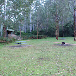
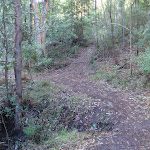

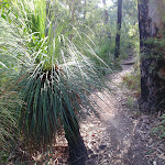
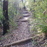
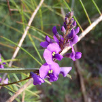
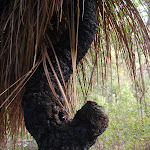
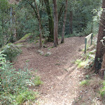
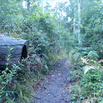
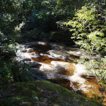

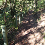
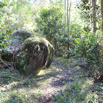
Mill Creek picnic area
This beautifully situated picnic area is located a short distance along an unsealed road, off Wisemans Ferry Rd, about 5.5km east of Wisemans Ferry. There are picnic tables, fireplaces, an information board and pit toilets. There is some excellent bush walking in the area with two signposted circuit walks starting from the end of the picnic area. There is a ‘large group’ camping area adjacent.
(0km) Mill Creek Picnic Area car park → Int of Grass Tree and 11km circuits
870 m
24 mins
84m
-48m
Moderate track
From the Mill Creek picnic area (signposted on Wisemans Ferry Rd, about 6km east of Wisemans Ferry crossing), the walk crosses from the information signs to the the ‘Start/Finish’ walking track signpost at the far end of the picnic area.
Continue straight: From the ‘Start/Finish’ walking track signpost at the end of the picnic area, the walk follows the bush track and immediately takes the right hand branch at a fork in the track (the other track is the return leg of the Grass Tree circuit). The walk passes through a mix of closed in, dense vegetation and more open forest with some beautiful views and lots of grasstrees. After crossing a creek using wooden steps and a concreted stone path, the track climbs more steeply before dropping to the signposted intersection of the ’11km Walking Track’ and ‘1.5km Grass Tree Circuit’.
Continue straight: From the ‘Start/Finish’ walking track signpost at the end of the picnic area, the walk follows the bush track and immediately takes the right hand branch at a fork in the track (the other track is the return leg of the Grass Tree circuit). The walk passes through a mix of closed in, dense vegetation and more open forest with some beautiful views and lots of grasstrees. After crossing a creek using wooden steps and a concreted stone path, the track climbs more steeply before dropping to the signposted intersection of the ’11km Walking Track’ and ‘1.5km Grass Tree Circuit’.
Grasstrees
The beautiful Grasstree is one of the icons of the Australian bush. It is a very slow growing plant, with the trunk typically only growing about one cm per year. These plants can grow and survive for several hundred years. The trunk is usually black, apparently a result of bushfires. As with some other native plants, fires can actually promote flowering and further growth. More info.
(0.87km) Int of Grass Tree and 11km circuits → 11km Big Tree creek crossing
810 m
22 mins
81m
-34m
Moderate track
Turn right: From the intersection, the walk follows the ’11km Walking Track’ arrow along the bush track. The track climbs for a while, with nice views down into the gully, before dropping to a picturesque creek crossing marked with a small ‘walker arrow’. From here the track climbs steeply for a short distance, then passes another track marker at the start of a section with beautiful rock overhangs and boulders. The track then drops to another creek crossing, marked with a small walker sign on a boulder in the middle of the creek, beneath a huge tree with impressive roots draping over the rocks. At the end of this side trip, retrace your steps back to the main walk then Turn right.
(0.87km) Int of Grass Tree and 11km circuits → Mill Creek Picnic Area car park
820 m
20 mins
25m
-62m
Moderate track
Veer left: From the intersection, the walk follows the bush track steeply down the hill. The track immediately goes down some steps and crosses the creek on a concreted stone path. Soon after this, the track crosses a minor gully and meanders for a while, through beautiful moist forest, before crossing the main creek again. The track continues through some drier forest for a while and arrives at the signposted track head at the end of the Mill Creek picnic area.
Continue straight: From the ‘Start/Finish’ walking track signpost at the end of the Mill Creek picnic area, the walk crosses the picnic area to the car park (Mill Creek picnic area is signposted on Wisemans Ferry Rd, about 6km east of Wisemans Ferry crossing).
Continue straight: From the ‘Start/Finish’ walking track signpost at the end of the Mill Creek picnic area, the walk crosses the picnic area to the car park (Mill Creek picnic area is signposted on Wisemans Ferry Rd, about 6km east of Wisemans Ferry crossing).
Maps for the Grass Tree circuit walk
You can download the PDF for this walk to print a map.
These maps below cover the walk and the wider area around the walk, they are worth carrying for safety reasons.
| Gunderman | 1:25 000 Map Series | 91313S GUNDERMAN | NSW-91313S |
| Lower Portland | 1:25 000 Map Series | 90312S LOWER PORTLAND | NSW-90312S |
| Gosford | 1:100 000 Map Series | 9131 GOSFORD | 9131 |
| St Albans | 1:100 000 Map Series | 9031 ST ALBANS | 9031 |
Cross sectional view of the Grass Tree circuit bushwalking track
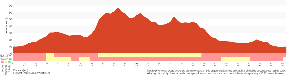
Analysis and summary of the altitude variation on the Grass Tree circuit
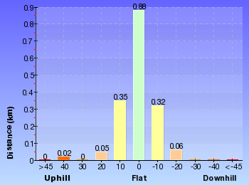
Overview of this walks grade – based on the AS 2156.1 – 2001
Under this standard, a walk is graded based on the most difficult section of the walk.
| Length | 1.7 km | ||
| Time | 1 Hr | ||
| . | |||
| Grade 3/6 Moderate track |
AS 2156.1 | Gradient | Short steep hills (3/6) |
| Quality of track | Formed track, with some branches and other obstacles (3/6) | ||
| Signs | Directional signs along the way (3/6) | ||
| Experience Required | Some bushwalking experience recommended (3/6) | ||
| Weather | Storms may impact on navigation and safety (3/6) | ||
| Infrastructure | Generally useful facilities (such as fenced cliffs and seats) (1/6) |
Some more details of this walks Grading
Here is a bit more details explaining grading looking at sections of the walk
Gradient
770m of this walk has short steep hills and another 720m has gentle hills with occasional steps. The remaining (210m) is flat with no steps.
Quality of track
Around 1.5km of this walk follows a formed track, with some branches and other obstacles, whilst the remaining 210m follows a clear and well formed track or trail.
Signs
Around 1.5km of this walk has directional signs at most intersection, whilst the remaining 210m is clearly signposted.
Experience Required
Around 1.5km of this walk requires some bushwalking experience, whilst the remaining 210m requires no previous bushwalking experience.
weather
Around 970m of this walk is not usually affected by severe weather events (that would unexpectedly impact safety and navigation), whilst the remaining 720m is affected by storms that may impact your navigation and safety.
Infrastructure
This whole walk, 1.7km is close to useful facilities (such as fenced cliffs and seats).
Similar walks
A list of walks that share part of the track with the Grass Tree circuit walk.
4.5 km Return
2 hrs 15 mins
Hard track
8.2 km Circuit
4 hrs 15 mins
Hard track
Other Nearby walks
A list of walks that start near the Grass Tree circuit walk.
28.3 km One way
2 Days
Moderate track
4.4 km Return
2 hrs 15 mins
Moderate track
3.6 km Return
2 hrs
Moderate track
9.9 km Circuit
4 hrs 30 mins
Moderate track
27.3 km One way
2 Days
Hard track
2.2 km Return
1 hr 15 mins
Moderate track
4.3 km Return
2 hrs
Moderate track
4 km One way
2 hrs
Moderate track
8.3 km Return
3 hrs 15 mins
Moderate track
10.8 km Circuit
4 hrs 15 mins
Hard track
10.1 km Return
4 hrs 15 mins
Hard track
4.4 km Return
2 hrs
Hard track
Plan your trip to and from the walk here
The Grass Tree circuit walk starts and ends at the Mill Creek Picnic Area car park (gps: -33.400835, 151.04778)
Your transport options to Mill Creek Picnic Area car park are by;
![]() Bus. Wisemans Ferry Dialacar provides a taxi style mini-bus service based in Wisemans Ferry. The cost is typically about per km (ex Wisemans Ferry). They will pick-up and drop-off from Sydney or the Central Coast and will happily drop walkers off or pick them up from tracks in the area. The cost for a pick-up from Gosford and drop off near Wisemans Ferry would be approximately 0 (please call for up-to-date pricing) and the minivan can carry up to 13 passengers. Phone: 0448 122 374 (get details)
Bus. Wisemans Ferry Dialacar provides a taxi style mini-bus service based in Wisemans Ferry. The cost is typically about per km (ex Wisemans Ferry). They will pick-up and drop-off from Sydney or the Central Coast and will happily drop walkers off or pick them up from tracks in the area. The cost for a pick-up from Gosford and drop off near Wisemans Ferry would be approximately 0 (please call for up-to-date pricing) and the minivan can carry up to 13 passengers. Phone: 0448 122 374 (get details)
![]() Car. There is free parking available.
Car. There is free parking available.
(get details)
Short URL = http://wild.tl/gtc
Gallery images
There are other downloads I am still working on.
You will probably need to login to access these — still all free.
* KML (google earth file)
* GPX (GPS file)
Special Maps/ brochures
* A3 topo maps
* PDF with Lands Topo map base
* PDF with arial image (and map overlay)
I wanted to get the main site live first, this extra stuff will come in time.
Happy walking
Matt 🙂
Comments