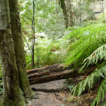
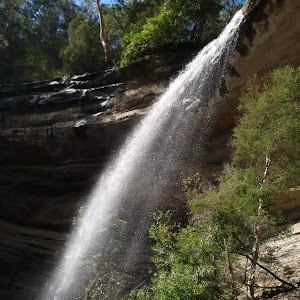
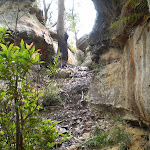
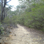
The Deep Pass Trail
And Walk
The Deep Pass Trail


1 Hr

0 m
Moderate track
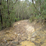


(0km) Deep Pass Carpark → Int of Nayook Crk and Carpark Servicetrail

900 m
14 mins
0m
0m
Moderate track
(0.9km) Int of Nayook Crk and Carpark Servicetrail → South-West End of Nayook Canyon
780 m
12 mins
0m
0m
Experienced only
(0.9km) Int of Nayook Crk and Carpark Servicetrail → Int of Carpark Servicetrail and Deep Pass Campground
140 m
2 mins
0m
0m
Moderate track
(1.04km) Int of Carpark Servicetrail and Deep Pass Campground → Deep Pass Carpark (South)
890 m
13 mins
0m
0m
Moderate track
Maps for the The Deep Pass Trail walk
You can download the PDF for this walk to print a map.
These maps below cover the walk and the wider area around the walk, they are worth carrying for safety reasons.
| Rock Hill | 1:25 000 Map Series | 89312N ROCK HILL | NSW-89312N |
| Wallerawang | 1:100 000 Map Series | 8931 WALLERAWANG | 8931 |
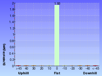
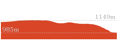
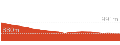
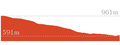
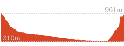
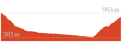
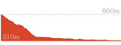
Cross sectional view of the The Deep Pass Trail bushwalking track

Analysis and summary of the altitude variation on the The Deep Pass Trail
Overview of this walks grade – based on the AS 2156.1 – 2001
Under this standard, a walk is graded based on the most difficult section of the walk.
| Length | 1.9 km | ||
| Time | 1 Hr | ||
| . | |||
| Grade 3/6 Moderate track |
AS 2156.1 | Gradient | Short steep hills (3/6) |
| Quality of track | Formed track, with some branches and other obstacles (3/6) | ||
| Signs | Directional signs along the way (3/6) | ||
| Experience Required | Some bushwalking experience recommended (3/6) | ||
| Weather | Weather generally has little impact on safety (1/6) | ||
| Infrastructure | Limited facilities, not all cliffs are fenced (3/6) |
Some more details of this walks Grading
Here is a bit more details explaining grading looking at sections of the walk
Gradient
Around 1.8km of this walk has short steep hills, whilst the remaining 140m is flat with no steps.
Quality of track
Around 1km of this walk follows a clear and well formed track or trail, whilst the remaining 890m follows a formed track, with some branches and other obstacles.
Signs
Around 1km of this walk is clearly signposted, whilst the remaining 900m has directional signs at most intersection.
Experience Required
Around 1km of this walk requires no previous bushwalking experience, whilst the remaining 890m requires some bushwalking experience.
weather
This whole walk, 1.9km is not usually affected by severe weather events (that would unexpectedly impact safety and navigation).
Infrastructure
This whole walk, 1.9km has limited facilities (such as not all cliffs fenced).
Similar walks
A list of walks that share part of the track with the The Deep Pass Trail walk.
2.2 km Circuit
45 mins
Experienced only

Other Nearby walks
A list of walks that start near the The Deep Pass Trail walk.

2.9 km Return
1 hr 45 mins
Moderate track

4.6 km Return
1 hr 45 mins
Moderate track
5.6 km Return
2 hrs
Hard track
4.2 km Return
1 hr 30 mins
Moderate track
6.4 km Return
2 hrs 30 mins
Very experienced only
3.1 km Return
2 hrs
Hard track
22.5 km One way
3 Days
Experienced only

206 m Return
15 mins
Moderate track
13.8 km One way
8 hrs
Experienced only
22.2 km One way
2 Days
Experienced only
8.9 km One way
2 Days
Experienced only
10.4 km One way
5 hrs 30 mins
Experienced only
Plan your trip to and from the walk here
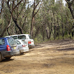
The The Deep Pass Trail walk starts at the Deep Pass Carpark (gps: -33.340204, 150.3001)
Your main transport option to Deep Pass Carpark is by;
![]() Car. There is free parking available.
Car. There is free parking available.
(get details)
The The Deep Pass Trail ends at the Deep Pass Carpark (South) (gps: -33.347409, 150.30684)
Your main transport option to Deep Pass Carpark (South) is by;
![]() Car. There is free parking available.
Car. There is free parking available.
(get details)


Short URL = http://wild.tl/tdpt
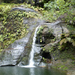
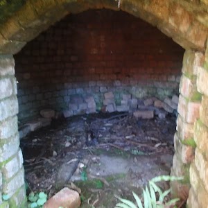
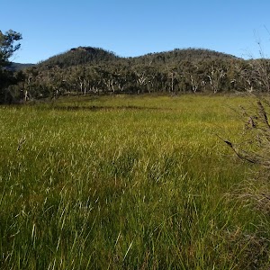
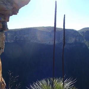
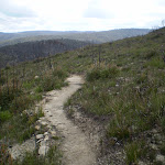
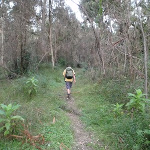
Gallery images
There are other downloads I am still working on.
You will probably need to login to access these — still all free.
* KML (google earth file)
* GPX (GPS file)
Special Maps/ brochures
* A3 topo maps
* PDF with Lands Topo map base
* PDF with arial image (and map overlay)
I wanted to get the main site live first, this extra stuff will come in time.
Happy walking
Matt 🙂
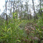
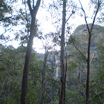
The Nayook Canyon Bushtrack
And Walk
The Nayook Canyon Bushtrack

45 mins
0 m
Experienced only
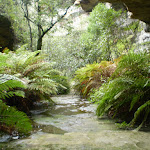
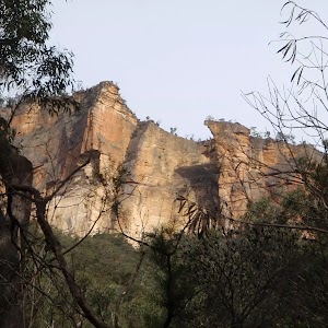
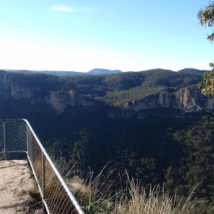
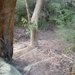
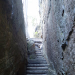
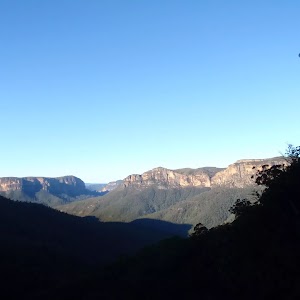
Passing close by one of the prettiest campsites in the Blue Mountains (Deep Pass), the Nayook Canyon Bushtrack explores the beautiful Nayook Creek. Winding its way through the ferns along the creek bed, climbing small cascading waterfalls and scrambling around rock-pools are all the delights of this walk. Care must be taken on slippery sections, with ropes to help on some steeper parts.* This walk passes through very remote areas and sections have no visible track. At least one person in your group should have training and experience in off track walking and navigation. Even with these notes and a GPS these extra skills and equipment are required.


(0km) Deep Pass Carpark → Int of Nayook Crk and Carpark Servicetrail
900 m
14 mins
0m
0m
Moderate track
(0.9km) Int of Nayook Crk and Carpark Servicetrail → South-West End of Nayook Canyon
780 m
12 mins
0m
0m
Experienced only
(1.69km) South-West End of Nayook Canyon → Deep Pass Carpark (North-West)
510 m
8 mins
0m
0m
Moderate track
Maps for the The Nayook Canyon Bushtrack walk
You can download the PDF for this walk to print a map.
These maps below cover the walk and the wider area around the walk, they are worth carrying for safety reasons.
| Rock Hill | 1:25 000 Map Series | 89312N ROCK HILL | NSW-89312N |
| Wallerawang | 1:100 000 Map Series | 8931 WALLERAWANG | 8931 |
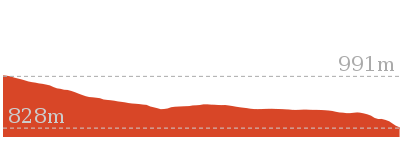
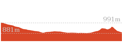
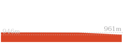
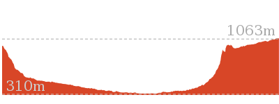
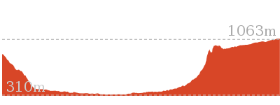
Cross sectional view of the The Nayook Canyon Bushtrack bushwalking track

Analysis and summary of the altitude variation on the The Nayook Canyon Bushtrack

Overview of this walks grade – based on the AS 2156.1 – 2001
Under this standard, a walk is graded based on the most difficult section of the walk.
| Length | 2.2 km | ||
| Time | 45 mins | ||
| . | |||
| Grade 5/6 Experienced only |
AS 2156.1 | Gradient | Short steep hills (3/6) |
| Quality of track | Rough unclear track (5/6) | ||
| Signs | No directional signs (5/6) | ||
| Experience Required | Moderate level of bushwalking experience recommended (4/6) | ||
| Weather | Forecast, unforecast storms and severe weather may impact on navigation and safety (4/6) | ||
| Infrastructure | No facilities provided (5/6) |
Some more details of this walks Grading
Here is a bit more details explaining grading looking at sections of the walk
Gradient
This whole walk, 2.2km has short steep hills.
Quality of track
900m of this walk follows a clear and well formed track or trail and another 780m follows a rough unclear track. The remaining (510m) follows a formed track, with some branches and other obstacles.
Signs
Around 1.4km of this walk has directional signs at most intersection, whilst the remaining 780m Has no directional signs.
Experience Required
900m of this walk requires no previous bushwalking experience and another 780m requires a leader a with moderate level of bushwalking experience. The remaining (510m) requires some bushwalking experience.
weather
Around 1.4km of this walk is not usually affected by severe weather events (that would unexpectedly impact safety and navigation), whilst the remaining 780m is affected by forecast, unforecast storms and severe weather events that may impact on navigation and safety.
Infrastructure
Around 1.4km of this walk has limited facilities (such as not all cliffs fenced), whilst the remaining 780m has no facilities provided.
Similar walks
A list of walks that share part of the track with the The Nayook Canyon Bushtrack walk.
1.9 km One way
1 Hr
Moderate track
Other Nearby walks
A list of walks that start near the The Nayook Canyon Bushtrack walk.
2.9 km Return
1 hr 45 mins
Moderate track
4.6 km Return
1 hr 45 mins
Moderate track
5.6 km Return
2 hrs
Hard track
4.2 km Return
1 hr 30 mins
Moderate track
6.4 km Return
2 hrs 30 mins
Very experienced only
3.1 km Return
2 hrs
Hard track
22.5 km One way
3 Days
Experienced only
206 m Return
15 mins
Moderate track
13.8 km One way
8 hrs
Experienced only
22.2 km One way
2 Days
Experienced only
8.9 km One way
2 Days
Experienced only
10.4 km One way
5 hrs 30 mins
Experienced only
Plan your trip to and from the walk here
The The Nayook Canyon Bushtrack walk starts and ends at the Deep Pass Carpark (gps: -33.340204, 150.3001)
Your main transport option to Deep Pass Carpark is by;
![]() Car. There is free parking available.
Car. There is free parking available.
(get details)
Short URL = http://wild.tl/tncb
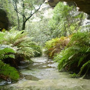
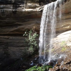
Gallery images
There are other downloads I am still working on.
You will probably need to login to access these — still all free.
* KML (google earth file)
* GPX (GPS file)
Special Maps/ brochures
* A3 topo maps
* PDF with Lands Topo map base
* PDF with arial image (and map overlay)
I wanted to get the main site live first, this extra stuff will come in time.
Happy walking
Matt 🙂
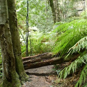
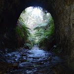
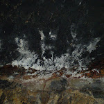
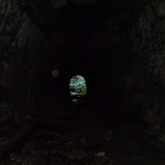
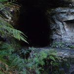
The Glow Worm Tunnel Walk
And Walk
The Glow Worm Tunnel Walk

1 hr 45 mins
0 m
Moderate track
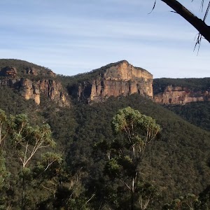
One of the most popular and famous tracks near Lithgow, the Glow Worm Tunnel Walk goes through a spectacular old railway tunnel. With thousands of glow worms along the sides and roof of the tunnel, a fascinating effect of the stars is produced. Remember, that it is necessary to be quiet so as not to disturb the glow worms. A torch is required – the tunnel is pretty long and it gets really dark in the middle.

(0km) End of Glowworm Tunnel Rd → Int of Glowworm Tunnel and Pagoda Servicetrails
1.2 km
18 mins
0m
0m
Moderate track
(1.17km) Int of Glowworm Tunnel and Pagoda Servicetrails → Eastern end of Glowworm tunnel
120 m
2 mins
0m
0m
Moderate track
(1.29km) Eastern end of Glowworm tunnel → Western end of Glowworm Tunnel
150 m
2 mins
0m
0m
Moderate track
Maps for the The Glow Worm Tunnel Walk walk
You can download the PDF for this walk to print a map.
These maps below cover the walk and the wider area around the walk, they are worth carrying for safety reasons.
| Ben Bullen | 1:25 000 Map Series | 89314S BEN BULLEN | NSW-89314S |
| Glen Alice | 1:50 000 Map Series | 89314 GLEN ALICE | CW-89314 |
| Wallerawang | 1:100 000 Map Series | 8931 WALLERAWANG | 8931 |
Cross sectional view of the The Glow Worm Tunnel Walk bushwalking track

Analysis and summary of the altitude variation on the The Glow Worm Tunnel Walk

Overview of this walks grade – based on the AS 2156.1 – 2001
Under this standard, a walk is graded based on the most difficult section of the walk.
| Length | 2.9 km | ||
| Time | 1 hr 45 mins | ||
| . | |||
| Grade 3/6 Moderate track |
AS 2156.1 | Gradient | Gentle hills with occasional steps (2/6) |
| Quality of track | Formed track, with some branches and other obstacles (3/6) | ||
| Signs | Clearly signposted (1/6) | ||
| Experience Required | Some bushwalking experience recommended (3/6) | ||
| Weather | Weather generally has little impact on safety (1/6) | ||
| Infrastructure | Limited facilities, not all cliffs are fenced (3/6) |
Some more details of this walks Grading
Here is a bit more details explaining grading looking at sections of the walk
Gradient
This whole walk, 1.4km has gentle hills with occasional steps.
Quality of track
Around 1.3km of this walk follows a clear and well formed track or trail, whilst the remaining 150m follows a formed track, with some branches and other obstacles.
Signs
This whole walk, 1.4km is clearly signposted.
Experience Required
Around 1.3km of this walk requires no previous bushwalking experience, whilst the remaining 150m requires some bushwalking experience.
weather
This whole walk, 1.4km is not usually affected by severe weather events (that would unexpectedly impact safety and navigation).
Infrastructure
This whole walk, 1.4km has limited facilities (such as not all cliffs fenced).
Similar walks
A list of walks that share part of the track with the The Glow Worm Tunnel Walk walk.
Other Nearby walks
A list of walks that start near the The Glow Worm Tunnel Walk walk.
1.9 km One way
1 Hr
Moderate track
2.2 km Circuit
45 mins
Experienced only
4.6 km Return
1 hr 45 mins
Moderate track
5.6 km Return
2 hrs
Hard track
4.2 km Return
1 hr 30 mins
Moderate track
6.4 km Return
2 hrs 30 mins
Very experienced only
3.1 km Return
2 hrs
Hard track
22.5 km One way
3 Days
Experienced only
206 m Return
15 mins
Moderate track
13.8 km One way
8 hrs
Experienced only
22.2 km One way
2 Days
Experienced only
8.9 km One way
2 Days
Experienced only
Plan your trip to and from the walk here
The The Glow Worm Tunnel Walk walk starts and ends at the End of Glowworm Tunnel Rd (gps: -33.247942, 150.22363)
Your main transport option to End of Glowworm Tunnel Rd is by;
![]() Car. There is free parking available.
Car. There is free parking available.
(get details)
Short URL = http://wild.tl/tgwtw
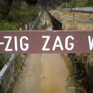
Gallery images
There are other downloads I am still working on.
You will probably need to login to access these — still all free.
* KML (google earth file)
* GPX (GPS file)
Special Maps/ brochures
* A3 topo maps
* PDF with Lands Topo map base
* PDF with arial image (and map overlay)
I wanted to get the main site live first, this extra stuff will come in time.
Happy walking
Matt 🙂
Zig-Zag Railway Walk
And Walk
Zig-Zag Railway Walk

1 hr 45 mins
245 m
Moderate track
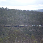
With a steam train ride from the end of the walk back to the start, the Zig-Zag Railway Walk is a very interesting one. Climbing to the ridges above the railway, this walk offers walkers the opportunity to watch the train as it puffs and hoots it’s way from Clarence Station to Bottom Points Station. And that’s even before you have a chance to get on the train and rest all the way back to the start, or alternatively retrace your steps back.


(0km) Clarence Station → Int of Leap Junction and Railway Tracks
690 m
13 mins
27m
-4m
Moderate track
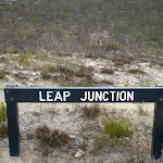
(0.69km) Int of Leap Junction and Railway Tracks → Leap Junction
860 m
19 mins
23m
-68m
Moderate track
(1.55km) Leap Junction → Bottom Points Railway Station
730 m
17 mins
4m
-119m
Moderate track
(2.28km) Bottom Points Railway Station → Clarence Station
6 km
45 mins
383m
-246m
Very easy
Maps for the Zig-Zag Railway Walk walk
You can download the PDF for this walk to print a map.
These maps below cover the walk and the wider area around the walk, they are worth carrying for safety reasons.
| Lithgow | 1:25 000 Map Series | 89313S LITHGOW | NSW-89313S |
| Wallerawang | 1:100 000 Map Series | 8931 WALLERAWANG | 8931 |
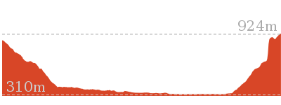
Cross sectional view of the Zig-Zag Railway Walk bushwalking track

Analysis and summary of the altitude variation on the Zig-Zag Railway Walk

Overview of this walks grade – based on the AS 2156.1 – 2001
Under this standard, a walk is graded based on the most difficult section of the walk.
| Length | 4.6 km | ||
| Time | 1 hr 45 mins | ||
| . | |||
| Grade 3/6 Moderate track |
AS 2156.1 | Gradient | Short steep hills (3/6) |
| Quality of track | Formed track, with some branches and other obstacles (3/6) | ||
| Signs | Clearly signposted (1/6) | ||
| Experience Required | Some bushwalking experience recommended (3/6) | ||
| Weather | Weather generally has little impact on safety (1/6) | ||
| Infrastructure | Limited facilities, not all cliffs are fenced (3/6) |
Some more details of this walks Grading
Here is a bit more details explaining grading looking at sections of the walk
Gradient
860m of this walk has gentle hills with occasional steps and another 730m has short steep hills. The remaining (690m) is flat with no steps.
Quality of track
Around 1.6km of this walk follows a formed track, with some branches and other obstacles, whilst the remaining 690m follows a clear and well formed track or trail.
Signs
This whole walk, 2.3km is clearly signposted.
Experience Required
Around 1.6km of this walk requires some bushwalking experience, whilst the remaining 690m requires no previous bushwalking experience.
weather
This whole walk, 2.3km is not usually affected by severe weather events (that would unexpectedly impact safety and navigation).
Infrastructure
This whole walk, 2.3km has limited facilities (such as not all cliffs fenced).
Similar walks
A list of walks that share part of the track with the Zig-Zag Railway Walk walk.
Other Nearby walks
A list of walks that start near the Zig-Zag Railway Walk walk.
5.6 km Return
2 hrs
Hard track
4.2 km Return
1 hr 30 mins
Moderate track
6.4 km Return
2 hrs 30 mins
Very experienced only
3.1 km Return
2 hrs
Hard track
22.5 km One way
3 Days
Experienced only
206 m Return
15 mins
Moderate track
13.8 km One way
8 hrs
Experienced only
22.2 km One way
2 Days
Experienced only
8.9 km One way
2 Days
Experienced only
10.4 km One way
5 hrs 30 mins
Experienced only
14 km Return
6 hrs 30 mins
Experienced only
17.6 km One way
9 hrs
Experienced only
Plan your trip to and from the walk here
The Zig-Zag Railway Walk walk starts and ends at the Clarence Station (gps: -33.477719, 150.22097)
Your main transport option to Clarence Station is by;
![]() Car. There is free parking available.
Car. There is free parking available.
(get details)
Short URL = http://wild.tl/zrw
Gallery images
There are other downloads I am still working on.
You will probably need to login to access these — still all free.
* KML (google earth file)
* GPX (GPS file)
Special Maps/ brochures
* A3 topo maps
* PDF with Lands Topo map base
* PDF with arial image (and map overlay)
I wanted to get the main site live first, this extra stuff will come in time.
Happy walking
Matt 🙂
Comments