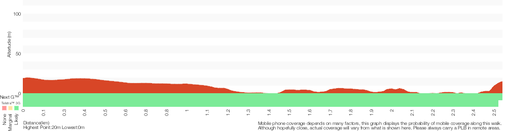
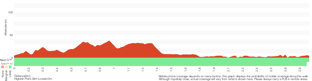
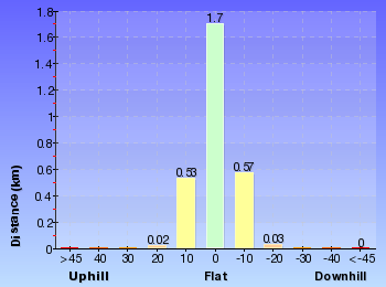
Lambeth Reserve to Picnic Point
And Walk
Lambeth Reserve to Picnic Point


30 mins

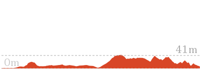
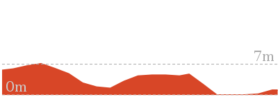
26 m
Very easy
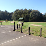

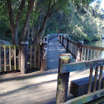
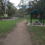


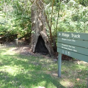
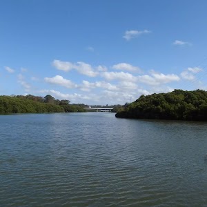
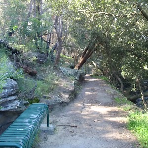
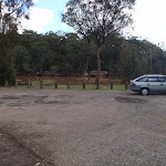
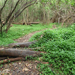
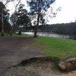
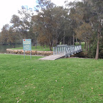
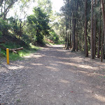
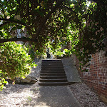
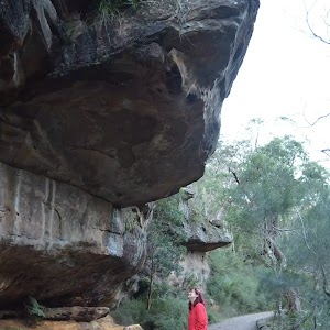
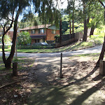
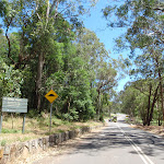
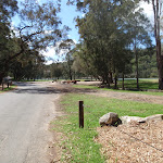
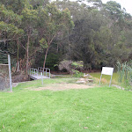
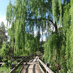
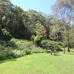
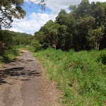
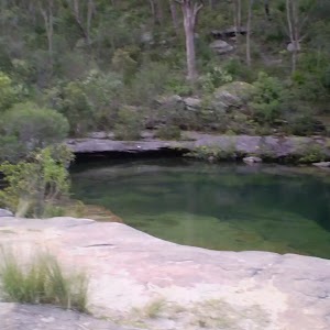
Lambeth Reserve
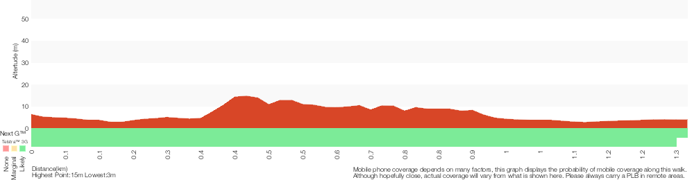
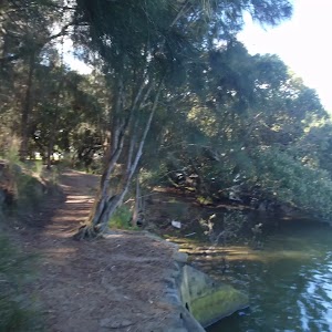
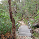
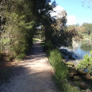
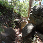
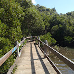
(0km) Lambeth Reserve carpark → Georges river boardwalk north

130 m
2 mins
0m
-3m
Very easy
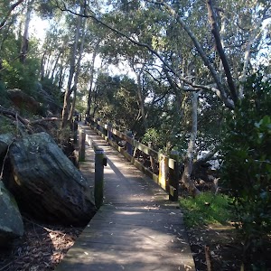
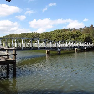
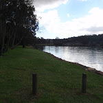
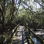
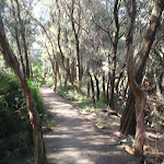
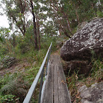
(0.13km) Georges river boardwalk north → Georges river boardwalk south
390 m
8 mins
16m
-7m
Very easy
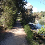
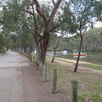
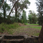
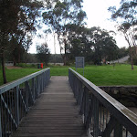
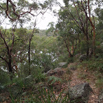
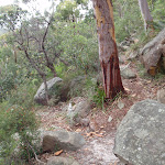
(0.52km) Georges river boardwalk south → Int of Georges river walk and Carinya road
490 m
9 mins
8m
-17m
Very easy
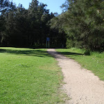
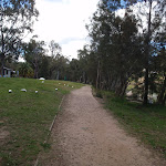
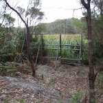
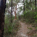
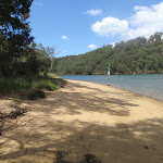
Continue straight: From the intersection, the walk follows the footpath south along the Georges river. The footpath runs through a long grassy clearing, between Carinya road and the river, and comes to the intersection with Carinya road, at the metal Gate near the sheltered picnic bench.
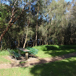
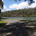
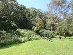
(1km) Int of Georges river walk and Carinya road → Picnic Point Boatshed
320 m
5 mins
2m
-2m
Very easy
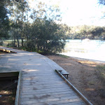
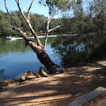
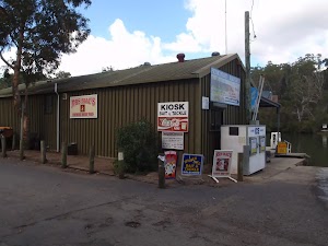
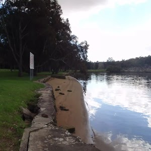
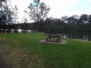
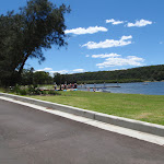
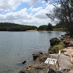
Picnic Point Boatshed
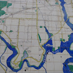
Maps for the Lambeth Reserve to Picnic Point walk
You can download the PDF for this walk to print a map.
These maps below cover the walk and the wider area around the walk, they are worth carrying for safety reasons.
| Liverpool | 1:25 000 Map Series | 90302S LIVERPOOL | NSW-90302S |
| Penrith | 1:100 000 Map Series | 9030 PENRITH | 9030 |
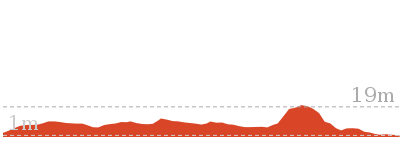
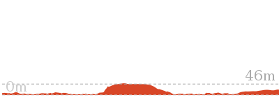
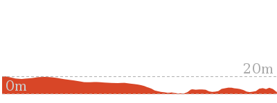
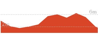
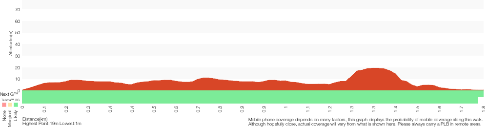
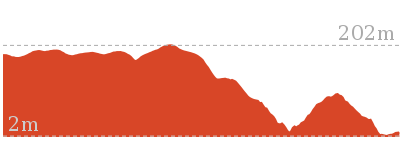
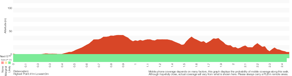
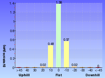
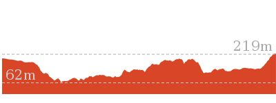
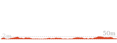
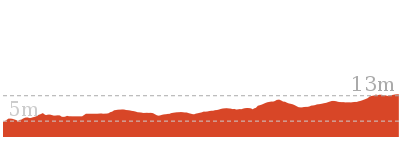
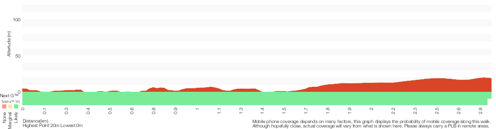
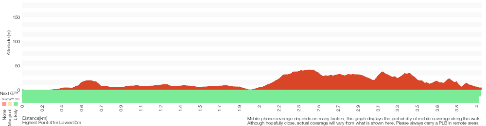
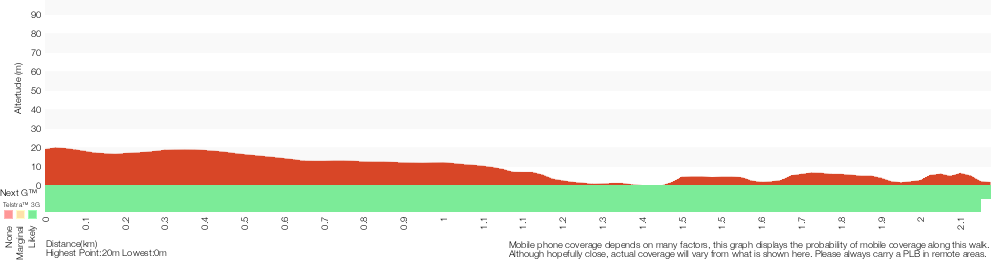
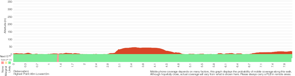
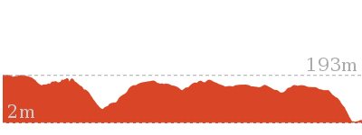
Cross sectional view of the Lambeth Reserve to Picnic Point bushwalking track
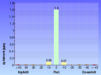
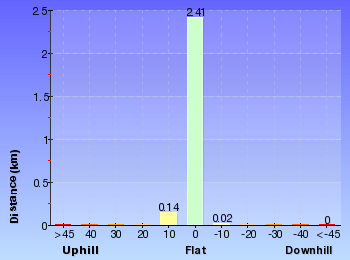
Analysis and summary of the altitude variation on the Lambeth Reserve to Picnic Point
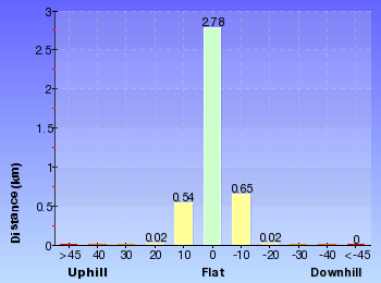
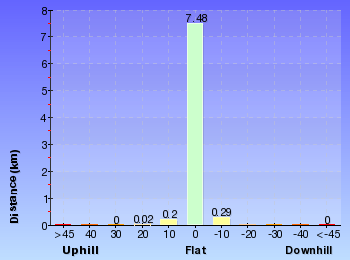
Overview of this walks grade – based on the AS 2156.1 – 2001
Under this standard, a walk is graded based on the most difficult section of the walk.
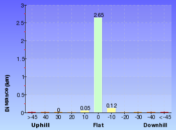
| Length | 1.3 km | ||
| Time | 30 mins | ||
| . | |||
| Grade 1/6 Very easy |
AS 2156.1 | Gradient | Flat, no steps (1/6) |
| Quality of track | Smooth and hardened path (1/6) | ||
| Signs | Clearly signposted (1/6) | ||
| Experience Required | No experience required (1/6) | ||
| Weather | Weather generally has little impact on safety (1/6) | ||
| Infrastructure | Generally useful facilities (such as fenced cliffs and seats) (1/6) |
Some more details of this walks Grading
Here is a bit more details explaining grading looking at sections of the walk
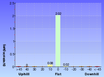
Gradient
This whole walk, 1.3km is flat with no steps.
Quality of track
This whole walk, 1.3km follows a smooth and hardened path.
Signs
This whole walk, 1.3km is clearly signposted.
Experience Required
This whole walk, 1.3km requires no previous bushwalking experience.
weather
This whole walk, 1.3km is not usually affected by severe weather events (that would unexpectedly impact safety and navigation).
Infrastructure
This whole walk, 1.3km is close to useful facilities (such as fenced cliffs and seats).
Similar walks
A list of walks that share part of the track with the Lambeth Reserve to Picnic Point walk.

15.8 km One way
5 hrs 30 mins
Moderate track
Other Nearby walks
A list of walks that start near the Lambeth Reserve to Picnic Point walk.
1.8 km Circuit
45 mins
Moderate track
2.5 km One way
1 hr 15 mins
Moderate track
4 km One way
1 hr 45 mins
Moderate track
2.9 km Circuit
1 hr 15 mins
Hard track

769 m Circuit
30 mins
Moderate track
8 km One way
2 hrs 45 mins
Moderate track
2.8 km One way
1 Hr
Moderate track
4.3 km Return
1 hr 30 mins
Very easy

2.6 km One way
1 Hr
Moderate track
1 km Return
20 mins
Very easy
1.2 km One way
30 mins
Moderate track
566 m Return
15 mins
Very easy
Plan your trip to and from the walk here
The Lambeth Reserve to Picnic Point walk starts at the Lambeth Reserve carpark (gps: -33.972325, 150.99716)
Your transport options to Lambeth Reserve carpark are by;
![]() Bus. (get details)
Bus. (get details)
![]() Car. There is free parking available.
Car. There is free parking available.
(get details)
The Lambeth Reserve to Picnic Point ends at the Picnic Point Boatshed (gps: -33.981355, 150.99671)
Your transport options to Picnic Point Boatshed are by;
![]() Bus. (get details)
Bus. (get details)
![]() Car. There is free parking available.
Car. There is free parking available.
(get details)


Short URL = http://wild.tl/lrtpp
Gallery images
There are other downloads I am still working on.
You will probably need to login to access these — still all free.
* KML (google earth file)
* GPX (GPS file)
Special Maps/ brochures
* A3 topo maps
* PDF with Lands Topo map base
* PDF with arial image (and map overlay)
I wanted to get the main site live first, this extra stuff will come in time.
Happy walking
Matt 🙂
Yeramba Lagoon Loop
And Walk
Yeramba Lagoon Loop

45 mins
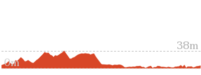
37 m
Moderate track


(0km) Yeramba Lagoon car park → Observation frame
350 m
6 mins
9m
-2m
Moderate track
(0.35km) Observation frame → Int of Lagoon bushtrack and Henry Lawson Drive
1.3 km
24 mins
27m
-34m
Moderate track
Continue straight: From the intersection, this walk follows the bush track alongside the lagoon (keeping it on the left), following the water’s edge for a short while. The track then turns up through the bush, winding among some short grass trees and up a rock outcrop. The track passes a burnt car then comes to a ‘Y’ intersection with the Sub Station bush track.
Veer left: From the intersection, this walk follows the bush track heading north along the rocky path (keeping the lagoon on the left), climbing the gentle hill to the top. The track come to a smaller intersection with a bush track, just before a more obvious intersection.
Turn left: From the intersection, this walk follows the bush track, heading down the hill and past the top of a large rock platform. The track continues along to the intersection with a bush track a short while later.
Veer left: From the intersection, this walk follows the bush track heading down the hill towards the dense green forest. The track winds down to the bottom of the hill and continues under the thick tree canopy, crossing to the other side of the creek where the walk comes out at an intersection with a bush track
Veer left: From the intersection, this walk follows the bush track heading towards the lagoon, away from the thick tree canopy. The track winds through the bush, among some thick grass trees, until coming to the top of a rocky hill, where there is a ‘Y’ intersection with more bush tracks
Continue straight: From the intersection, this walk follows the bush track uphill, keeping the lagoon to the left. The walk passes through the gap in the rock and continues along the bush track until coming to an intersection with another bush track at the arrow signpost.
Veer left: From the intersection, this walk follows the arrow (on the right-hand side of the track), heading along the bush track to the south. The walk winds through the trees for a while until heading down a rock staircase that zigzags to the bottom of the hill. The track then continues through bracken ferns and grass trees, passing around the edge of the lagoon and across a short wooden bridge to the grass clearing near the gap in the safety railing on Henry Lawson Drive.
(1.66km) Int of Lagoon bushtrack and Henry Lawson Drive → Yeramba Lagoon car park
110 m
2 mins
1m
-2m
Very easy
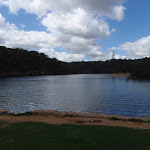
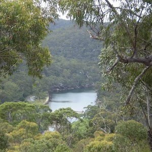
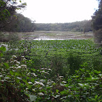
Yerambah Lagoon

Maps for the Yeramba Lagoon Loop walk
You can download the PDF for this walk to print a map.
These maps below cover the walk and the wider area around the walk, they are worth carrying for safety reasons.
| Botany Bay | 1:25 000 Map Series | 91303S BOTANY BAY | NSW-91303S |
| Sydney | 1:100 000 Map Series | 9130 SYDNEY | 9130 |
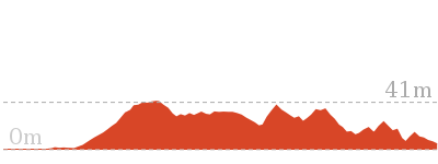
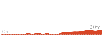
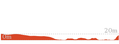
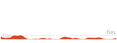
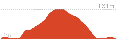
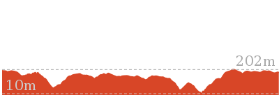
Cross sectional view of the Yeramba Lagoon Loop bushwalking track
Analysis and summary of the altitude variation on the Yeramba Lagoon Loop
Overview of this walks grade – based on the AS 2156.1 – 2001
Under this standard, a walk is graded based on the most difficult section of the walk.
| Length | 1.8 km | ||
| Time | 45 mins | ||
| . | |||
| Grade 3/6 Moderate track |
AS 2156.1 | Gradient | Short steep hills (3/6) |
| Quality of track | Formed track, with some branches and other obstacles (3/6) | ||
| Signs | Directional signs along the way (3/6) | ||
| Experience Required | Some bushwalking experience recommended (3/6) | ||
| Weather | Weather generally has little impact on safety (1/6) | ||
| Infrastructure | Limited facilities, not all cliffs are fenced (3/6) |
Some more details of this walks Grading
Here is a bit more details explaining grading looking at sections of the walk
Gradient
1.3km of this walk has gentle hills with occasional steps and another 400m has short steep hills. The remaining (110m) is flat with no steps.
Quality of track
Around 1.7km of this walk follows a formed track, with some branches and other obstacles, whilst the remaining 110m follows a smooth and hardened path.
Signs
Around 1.7km of this walk has directional signs at most intersection, whilst the remaining 110m is clearly signposted.
Experience Required
Around 1.1km of this walk requires some bushwalking experience, whilst the remaining 630m requires no previous bushwalking experience.
weather
This whole walk, 1.8km is not usually affected by severe weather events (that would unexpectedly impact safety and navigation).
Infrastructure
Around 990m of this walk has limited facilities (such as not all cliffs fenced), whilst the remaining 780m is close to useful facilities (such as fenced cliffs and seats).
Similar walks
A list of walks that share part of the track with the Yeramba Lagoon Loop walk.
2.5 km One way
1 hr 15 mins
Moderate track
4 km One way
1 hr 45 mins
Moderate track
15.8 km One way
5 hrs 30 mins
Moderate track
Other Nearby walks
A list of walks that start near the Yeramba Lagoon Loop walk.
1.3 km One way
30 mins
Very easy

8 km One way
2 hrs 45 mins
Moderate track
2.9 km Circuit
1 hr 15 mins
Hard track
769 m Circuit
30 mins
Moderate track
2.8 km One way
1 Hr
Moderate track
4.3 km Return
1 hr 30 mins
Very easy
2.6 km One way
1 Hr
Moderate track
1 km Return
20 mins
Very easy
1.2 km One way
30 mins
Moderate track
566 m Return
15 mins
Very easy
11 km One way
4 hrs
Hard track
5.8 km One way
2 hrs 30 mins
Hard track
Plan your trip to and from the walk here
The Yeramba Lagoon Loop walk starts and ends at the Yeramba Lagoon car park (gps: -33.978524, 151.00379)
Your transport options to Yeramba Lagoon car park are by;
![]() Bus. (get details)
Bus. (get details)
![]() Car. There is free parking available.
Car. There is free parking available.
(get details)
Short URL = http://wild.tl/yll
Gallery images
There are other downloads I am still working on.
You will probably need to login to access these — still all free.
* KML (google earth file)
* GPX (GPS file)
Special Maps/ brochures
* A3 topo maps
* PDF with Lands Topo map base
* PDF with arial image (and map overlay)
I wanted to get the main site live first, this extra stuff will come in time.
Happy walking
Matt 🙂
Fitzpatrick Park to Georges River National Park

1 hr 15 mins
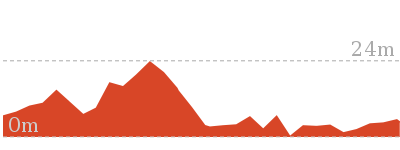
112 m
Moderate track
This walk starts from the end of the Fitzpatrick Park driveway and follows the Georges River. The walk heads downstream along the waters edge, through the park and across the bridge, to the half way point at Henry Lawson Drive. From here the walk continues along a series of bush tracks, winding along the ridge, around to the Georges River National Park driveway.


Fitzpatrick Park
(0km) End of Fitzpatrick Park drive way → Int of Lagoon bushtrack and Henry Lawson Drive
320 m
5 mins
2m
-2m
Moderate track
(0.32km) Int of Lagoon bushtrack and Henry Lawson Drive → Yeramba Lagoon car park
110 m
2 mins
1m
-2m
Very easy
(0.43km) Yeramba Lagoon carpark → Int of Henry Lawson Drive and Ridgetop bushtrack
70 m
1 mins
4m
0m
Easy track
(0.5km) Int of Henry Lawson Drive and Ridgetop bushtrack → Int of Ridgetop service trail and loop track
270 m
7 mins
33m
0m
Moderate track
Continue straight: From the intersection, this walk follows the bush track heading south-east through the bush, winding around for a short distance to the intersection of the Ridgetop service trail.
(0.77km) Int of Ridgetop service trail and loop track → Int of Ridge Track and Ridgetop service trail
140 m
2 mins
4m
-1m
Moderate track
(0.91km) Int of Ridge Track and Ridgetop service trail → Int of Morgans Creek and the Ridge Track
1.6 km
38 mins
68m
-104m
Moderate track
Veer right: From the intersection, this walk follows the ‘Morgans Creek’ arrow along the bush track, crossing over some metal pipes and under two sets of power lines. The walk continues along the ridge for a while until it passing under a third set of power lines. The track then heads down the hill and across a small creek, to the intersection of an un-signposted bush track on the right.
Continue straight: From the intersection, this walk follows the bush track heading up through the thick bush and along the side of the ridge, keeping Georges River on the right. The track heads through some really nice sandstone rock formations, with plenty of gum trees and ferns around. As the track winds around a rock ledge, it comes to signposted track on the right (which heads down to Burrawang Reach).
Continue straight: From the intersection, this walk follows the ‘Morgans Creek 500m’ sign as it heads along the side of the ridge, with the Georges River visible through the trees to the right. The walk winds along until it turns down the ridge and heads down to the Georges River National Park driveway.
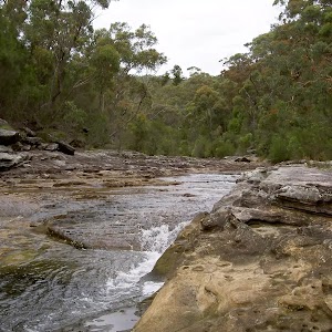
Morgans Creek
Maps for the Fitzpatrick Park to Georges River National Park walk
You can download the PDF for this walk to print a map.
These maps below cover the walk and the wider area around the walk, they are worth carrying for safety reasons.
| Botany Bay | 1:25 000 Map Series | 91303S BOTANY BAY | NSW-91303S |
| Sydney | 1:100 000 Map Series | 9130 SYDNEY | 9130 |
Cross sectional view of the Fitzpatrick Park to Georges River National Park bushwalking track
Analysis and summary of the altitude variation on the Fitzpatrick Park to Georges River National Park
Overview of this walks grade – based on the AS 2156.1 – 2001
Under this standard, a walk is graded based on the most difficult section of the walk.
| Length | 2.5 km | ||
| Time | 1 hr 15 mins | ||
| . | |||
| Grade 3/6 Moderate track |
AS 2156.1 | Gradient | Short steep hills (3/6) |
| Quality of track | Formed track, with some branches and other obstacles (3/6) | ||
| Signs | Directional signs along the way (3/6) | ||
| Experience Required | Some bushwalking experience recommended (3/6) | ||
| Weather | Weather generally has little impact on safety (1/6) | ||
| Infrastructure | Limited facilities, not all cliffs are fenced (3/6) |
Some more details of this walks Grading
Here is a bit more details explaining grading looking at sections of the walk
Gradient
1.6km of this walk has gentle hills with occasional steps and another 610m is flat with no steps. The remaining (230m) has short steep hills.
Quality of track
2.2km of this walk follows a formed track, with some branches and other obstacles and another 180m follows a smooth and hardened path. The remaining (140m) follows a clear and well formed track or trail.
Signs
Around 1.6km of this walk is clearly signposted, whilst the remaining 840m has directional signs at most intersection.
Experience Required
Around 1.9km of this walk requires some bushwalking experience, whilst the remaining 630m requires no previous bushwalking experience.
weather
This whole walk, 2.5km is not usually affected by severe weather events (that would unexpectedly impact safety and navigation).
Infrastructure
Around 1.9km of this walk is close to useful facilities (such as fenced cliffs and seats), whilst the remaining 610m has limited facilities (such as not all cliffs fenced).
Similar walks
A list of walks that share part of the track with the Fitzpatrick Park to Georges River National Park walk.
769 m Circuit
30 mins
Moderate track
1.8 km Circuit
45 mins
Moderate track
2.9 km Circuit
1 hr 15 mins
Hard track
4 km One way
1 hr 45 mins
Moderate track
15.8 km One way
5 hrs 30 mins
Moderate track
Other Nearby walks
A list of walks that start near the Fitzpatrick Park to Georges River National Park walk.
1.3 km One way
30 mins
Very easy
8 km One way
2 hrs 45 mins
Moderate track
2.8 km One way
1 Hr
Moderate track
4.3 km Return
1 hr 30 mins
Very easy
2.6 km One way
1 Hr
Moderate track
1 km Return
20 mins
Very easy
1.2 km One way
30 mins
Moderate track
566 m Return
15 mins
Very easy
11 km One way
4 hrs
Hard track
5.8 km One way
2 hrs 30 mins
Hard track
918 m Return
20 mins
Very easy
10.1 km One way
5 hrs
Hard track
Plan your trip to and from the walk here
The Fitzpatrick Park to Georges River National Park walk starts at the End of Fitzpatrick Park drive way (gps: -33.981192, 151.00098)
Your transport options to End of Fitzpatrick Park drive way are by;
![]() Bus. (get details)
Bus. (get details)
![]() Car. There is free parking available.
Car. There is free parking available.
(get details)
The Fitzpatrick Park to Georges River National Park ends at the Int of Morgans Creek and the Ridge Track (gps: -33.975842, 151.0187)
Your transport options to Int of Morgans Creek and the Ridge Track are by;
![]() Bus. (get details)
Bus. (get details)
![]() Car. There is free parking available.
Car. There is free parking available.
(get details)
Short URL = http://wild.tl/fptgrnp
Gallery images
There are other downloads I am still working on.
You will probably need to login to access these — still all free.
* KML (google earth file)
* GPX (GPS file)
Special Maps/ brochures
* A3 topo maps
* PDF with Lands Topo map base
* PDF with arial image (and map overlay)
I wanted to get the main site live first, this extra stuff will come in time.
Happy walking
Matt 🙂
Padstow to the Salt Pan Creek Picnic Area

1 Hr
40 m
Moderate track
This walk starts from Pastow train station and follows the streets to the end of Bridge street before it heads down stream along the boardwalks, service trails and bushtracks that follow the creek. As the walk winds along the creek, it passes the Davies Reserve and the small picnic area under the large pipe bridge. The walk then comes to the smaller Salt Pan creek picnic area, on the creeks edge, with a metal staircase providing access to Werona Avenue.


(0km) Padstow Railway Station → Int of Davies Road and Meager Avenue
810 m
13 mins
4m
-10m
Very easy
Howard Road shops
(0.81km) Int of Davies Road and Meager Avenue → End of Bridge Street
330 m
6 mins
0m
-6m
Very easy
(1.14km) End of Bridge Street → End of Meager Ave
340 m
6 mins
6m
-8m
Very easy
Turn right: ###This section of the track is closed for End of 2010 to sometime in 2011. Please walk along Meager Ave from Davies Rd as an alternate route###
From the intersection, the walk passes under the railway bridge and along the boardwalk, as it winds around the edge of the creek and through some mangroves to a hardened footpath. The footpath leads up a gentle hill for a short distance to the end of Meager Avenue.
(1.48km) End of Meager Ave → Davies Reserve
360 m
7 mins
6m
-6m
Very easy
Continue straight: From the intersection, this walk heads along the fenced boardwalk parallel to the power lines (with the open wetlands to the right) for a short distance until coming to the Davies Reserve.
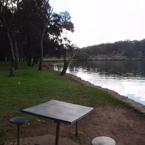
Davies Reserve
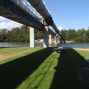
(1.85km) Davies Reserve → Picnic area at base of Pipe Bridge
280 m
6 mins
6m
-10m
Very easy
Pipe bridge picnic area
(2.13km) Picnic area at base of Pipe Bridge → Bottom of Weenamana Place steps
170 m
3 mins
2m
-2m
Easy track
(2.3km) Bottom of Weenamana Place steps → Salt Pan Creek picnic area
220 m
4 mins
4m
-3m
Moderate track
Salt Pan Creek picnic area
(2.52km) Salt Pan Creek picnic area → Int of Werona Avenue and Salt Pan creek path
70 m
2 mins
12m
0m
Moderate track
Maps for the Padstow to the Salt Pan Creek Picnic Area walk
You can download the PDF for this walk to print a map.
These maps below cover the walk and the wider area around the walk, they are worth carrying for safety reasons.
| Botany Bay | 1:25 000 Map Series | 91303S BOTANY BAY | NSW-91303S |
| Sydney | 1:100 000 Map Series | 9130 SYDNEY | 9130 |
Cross sectional view of the Padstow to the Salt Pan Creek Picnic Area bushwalking track
Analysis and summary of the altitude variation on the Padstow to the Salt Pan Creek Picnic Area
Overview of this walks grade – based on the AS 2156.1 – 2001
Under this standard, a walk is graded based on the most difficult section of the walk.
| Length | 2.6 km | ||
| Time | 1 Hr | ||
| . | |||
| Grade 3/6 Moderate track |
AS 2156.1 | Gradient | Short steep hills (3/6) |
| Quality of track | Clear and well formed track or trail (2/6) | ||
| Signs | Directional signs along the way (3/6) | ||
| Experience Required | No experience required (1/6) | ||
| Weather | Weather generally has little impact on safety (1/6) | ||
| Infrastructure | Generally useful facilities (such as fenced cliffs and seats) (1/6) |
Some more details of this walks Grading
Here is a bit more details explaining grading looking at sections of the walk
Gradient
2.1km of this walk is flat with no steps and another 390m has gentle hills with occasional steps. The remaining (70m) has short steep hills.
Quality of track
Around 2.1km of this walk follows a smooth and hardened path, whilst the remaining 460m follows a clear and well formed track or trail.
Signs
Around 2.3km of this walk is clearly signposted, whilst the remaining 290m has directional signs at most intersection.
Experience Required
This whole walk, 2.6km requires no previous bushwalking experience.
weather
This whole walk, 2.6km is not usually affected by severe weather events (that would unexpectedly impact safety and navigation).
Infrastructure
This whole walk, 2.6km is close to useful facilities (such as fenced cliffs and seats).
Similar walks
A list of walks that share part of the track with the Padstow to the Salt Pan Creek Picnic Area walk.
566 m Return
15 mins
Very easy
1 km Return
20 mins
Very easy
1.2 km One way
30 mins
Moderate track
2.8 km One way
1 Hr
Moderate track
4.3 km Return
1 hr 30 mins
Very easy
8 km One way
2 hrs 45 mins
Moderate track
15.8 km One way
5 hrs 30 mins
Moderate track
Other Nearby walks
A list of walks that start near the Padstow to the Salt Pan Creek Picnic Area walk.
2.9 km Circuit
1 hr 15 mins
Hard track
769 m Circuit
30 mins
Moderate track
1.3 km One way
30 mins
Very easy
1.8 km Circuit
45 mins
Moderate track
2.5 km One way
1 hr 15 mins
Moderate track
4 km One way
1 hr 45 mins
Moderate track
11 km One way
4 hrs
Hard track
13.4 km One way
5 hrs
Hard track
918 m Return
20 mins
Very easy
5.8 km One way
2 hrs 30 mins
Hard track
2.2 km Return
45 mins
Easy track
2.3 km Circuit
1 hr 15 mins
Hard track
Plan your trip to and from the walk here
The Padstow to the Salt Pan Creek Picnic Area walk starts at the Padstow Railway Station (gps: -33.951899, 151.03197)
Your transport options to Padstow Railway Station are by;
![]() Train. (get details)
Train. (get details)
![]() Bus. (get details)
Bus. (get details)
![]() Car. There is free parking available.
Car. There is free parking available.
(get details)
The Padstow to the Salt Pan Creek Picnic Area ends at the Int of Werona Avenue and Salt Pan creek path (gps: -33.960467, 151.03916)
Your transport options to Int of Werona Avenue and Salt Pan creek path are by;
![]() Bus. (get details)
Bus. (get details)
![]() Car. There is free parking available.
Car. There is free parking available.
(get details)
Short URL = http://wild.tl/pttspcpa
Gallery images
There are other downloads I am still working on.
You will probably need to login to access these — still all free.
* KML (google earth file)
* GPX (GPS file)
Special Maps/ brochures
* A3 topo maps
* PDF with Lands Topo map base
* PDF with arial image (and map overlay)
I wanted to get the main site live first, this extra stuff will come in time.
Happy walking
Matt 🙂
Alma Road to Padstow along Salt Pan Creek

1 Hr
52 m
Moderate track
This short walk starts from the corner of Alma Road and Wainright Avenue and follows the footpath down to Salt Pan Creek walk. The walk then follows the creek upstream along the boardwalks and bushtracks, passing a few great picnic areas and parks to the end of Bridge Street. From here the walk follows the roads across the railway bridge and along to the Padstow train station, where there are a few shops.


(0km) Corner of Alma Road and Wainwright Avenue → Bottom of Alma Road track
60 m
1 mins
2m
-4m
Very easy
(0.06km) Bottom of Alma Road track → Salt Pan Creek picnic area
260 m
5 mins
5m
-4m
Moderate track
Salt Pan Creek picnic area
(0.32km) Salt Pan Creek picnic area → Picnic area at base of Pipe Bridge
390 m
7 mins
5m
-6m
Moderate track
Continue straight: From the bottom of the steps, this walk follows the boardwalk as it winds alongside the river (keeping the river on the right), through mangroves for a short while. Soon the boardwalk becomes a bush track and continues to the picnic area under the large pipe bridge.
Pipe bridge picnic area
(0.71km) Picnic area at base of Pipe Bridge → Davies Reserve
280 m
6 mins
10m
-6m
Very easy
Davies Reserve
(0.99km) Davies Reserve → End of Bridge Street
700 m
13 mins
14m
-12m
Very easy
Continue straight: From the intersection, the walk continues along the short board walk (keeping the power lines above to the right). Soon the boardwalk joins onto a hardened footpath, which continues along through the grass clearing, running parallel to Salt Pan Creek. The track passes behind a number of houses, and then passes a couple of transmission towers as the footpath tends left to the end of Meager Avenue.
Veer right: ###This section of the track is closed for End of 2010 to sometime in 2011. Please walk along Meager Ave to Davies Rd as an alternate route###
From the end of Meager Ave, the walk follows the footpath lined with wooden posts (with the white house at no.2 initially on the left) into the bush and down the gentle hill. After a short distance, the footpath joins a board walk and continues through some mangroves and out to the creek edge. The boardwalk then turns left, crossing under the railway bridge to the intersection with the Salt Pan Creek footbridge on the right.
Turn left: From the intersection, this walk follows the boardwalk around the creek’s edge (keeping the train line on the left) and through some mangroves for a short distance, until coming to a concrete footpath. This path continues past a transmission tower to the end of Bridge Street.
(1.7km) End of Bridge Street → Padstow Railway Station
1.1 km
19 mins
16m
-4m
Very easy
Continue straight: From the intersection, this walk heads south (away from the trail line) along Davies Road, along the footpath. After a short while, the walk turns right into Ryan Rd, crossing at the traffic lights. This walk follows the footpath through the suburbs to cross, straight ahead at the roundabout, onto Howard Road. The road then passes a few shops and comes to the Padstow railway station on the right.
Howard Road shops
Maps for the Alma Road to Padstow along Salt Pan Creek walk
You can download the PDF for this walk to print a map.
These maps below cover the walk and the wider area around the walk, they are worth carrying for safety reasons.
| Botany Bay | 1:25 000 Map Series | 91303S BOTANY BAY | NSW-91303S |
| Sydney | 1:100 000 Map Series | 9130 SYDNEY | 9130 |
Cross sectional view of the Alma Road to Padstow along Salt Pan Creek bushwalking track
Analysis and summary of the altitude variation on the Alma Road to Padstow along Salt Pan Creek
Overview of this walks grade – based on the AS 2156.1 – 2001
Under this standard, a walk is graded based on the most difficult section of the walk.
| Length | 2.8 km | ||
| Time | 1 Hr | ||
| . | |||
| Grade 3/6 Moderate track |
AS 2156.1 | Gradient | Gentle hills with occasional steps (2/6) |
| Quality of track | Formed track, with some branches and other obstacles (3/6) | ||
| Signs | Directional signs along the way (3/6) | ||
| Experience Required | Some bushwalking experience recommended (3/6) | ||
| Weather | Weather generally has little impact on safety (1/6) | ||
| Infrastructure | Generally useful facilities (such as fenced cliffs and seats) (1/6) |
Some more details of this walks Grading
Here is a bit more details explaining grading looking at sections of the walk
Gradient
Around 2.2km of this walk is flat with no steps, whilst the remaining 650m has gentle hills with occasional steps.
Quality of track
2.2km of this walk follows a smooth and hardened path and another 390m follows a clear and well formed track or trail. The remaining (260m) follows a formed track, with some branches and other obstacles.
Signs
Around 2.4km of this walk is clearly signposted, whilst the remaining 480m has directional signs at most intersection.
Experience Required
Around 2.6km of this walk requires no previous bushwalking experience, whilst the remaining 260m requires some bushwalking experience.
weather
This whole walk, 2.8km is not usually affected by severe weather events (that would unexpectedly impact safety and navigation).
Infrastructure
This whole walk, 2.8km is close to useful facilities (such as fenced cliffs and seats).
Similar walks
A list of walks that share part of the track with the Alma Road to Padstow along Salt Pan Creek walk.
566 m Return
15 mins
Very easy
1 km Return
20 mins
Very easy
1.2 km One way
30 mins
Moderate track
2.6 km One way
1 Hr
Moderate track
4.3 km Return
1 hr 30 mins
Very easy
8 km One way
2 hrs 45 mins
Moderate track
15.8 km One way
5 hrs 30 mins
Moderate track
Other Nearby walks
A list of walks that start near the Alma Road to Padstow along Salt Pan Creek walk.
2.9 km Circuit
1 hr 15 mins
Hard track
769 m Circuit
30 mins
Moderate track
1.3 km One way
30 mins
Very easy
1.8 km Circuit
45 mins
Moderate track
2.5 km One way
1 hr 15 mins
Moderate track
4 km One way
1 hr 45 mins
Moderate track
11 km One way
4 hrs
Hard track
918 m Return
20 mins
Very easy
5.8 km One way
2 hrs 30 mins
Hard track
13.4 km One way
5 hrs
Hard track
2.2 km Return
45 mins
Easy track
2.3 km Circuit
1 hr 15 mins
Hard track
Plan your trip to and from the walk here
The Alma Road to Padstow along Salt Pan Creek walk starts at the Corner of Alma Road and Wainwright Avenue (gps: -33.962739, 151.03949)
Your transport options to Corner of Alma Road and Wainwright Avenue are by;
![]() Bus. (get details)
Bus. (get details)
![]() Car. There is free parking available.
Car. There is free parking available.
(get details)
The Alma Road to Padstow along Salt Pan Creek ends at the Padstow Railway Station (gps: -33.951899, 151.03197)
Your transport options to Padstow Railway Station are by;
![]() Train. (get details)
Train. (get details)
![]() Bus. (get details)
Bus. (get details)
![]() Car. There is free parking available.
Car. There is free parking available.
(get details)
Short URL = http://wild.tl/artpaspc
Gallery images
There are other downloads I am still working on.
You will probably need to login to access these — still all free.
* KML (google earth file)
* GPX (GPS file)
Special Maps/ brochures
* A3 topo maps
* PDF with Lands Topo map base
* PDF with arial image (and map overlay)
I wanted to get the main site live first, this extra stuff will come in time.
Happy walking
Matt 🙂
The Ridge Track Loop
And Walk
The Ridge Track Loop

1 hr 15 mins
123 m
Hard track
This circuit walk follows the well signposted Ridge Track as it winds up through the bush between Henry Lawson Drive and the Georges River. The walk starts at Morgans Creek picnic area and heads back down to the river at Cattle Duffers Flats, then loops back to the start along the driveway. This walk is a great way to explore the diverse plants, and views of the park.

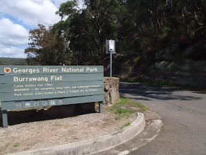
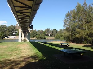
Morgans Creek
(0km) Int of Morgans Creek and the Ridge Track → Int of Ridge and Burrawang Flat tracks
350 m
9 mins
26m
-16m
Moderate track
(0.35km) Int of Ridge and Burrawang Flat tracks → Int of Ridge and Cattle Duffers Flats tracks
980 m
23 mins
62m
-45m
Moderate track
Continue straight: From the intersection, this walk follows the bush track winding along the side of the ridge, with the Georges River visible through the trees to the left. The track heads along the side of the hill, crossing a small creek and heading uphill on the other side. The walk goes under a set of power lines, then along the ridge for a while before crossing under two more sets of power lines and over some metal pipes. The track then comes to a signposted intersection with a track on the left (which heads down to Cattle Duffers Flats).
(1.34km) Int of Ridge and Cattle Duffers Flats tracks → Northern point of Cattle Duffers Flat
120 m
4 mins
0m
-24m
Hard track
(1.45km) Northern point of Cattle Duffers Flat → Int of the Ridge Access Track at Burrawang Flats
1 km
19 mins
24m
-29m
Very easy
Continue straight: From the intersection, the walk follows the road, keeping Georges River on the right. The walk continues past the sign into Cattle Duffers Flat and passes a toilet block, following the river for a while until coming to another toilet block at the signposted intersection of the ‘Ridge Track’ (on the left side of the road at Burrawang Flat).
(2.5km) Int of the Ridge Access Track at Burrawang Flats → Int of Morgans Creek and the Ridge Track
360 m
7 mins
11m
-9m
Easy track
Maps for the The Ridge Track Loop walk
You can download the PDF for this walk to print a map.
These maps below cover the walk and the wider area around the walk, they are worth carrying for safety reasons.
| Botany Bay | 1:25 000 Map Series | 91303S BOTANY BAY | NSW-91303S |
| Sydney | 1:100 000 Map Series | 9130 SYDNEY | 9130 |
Cross sectional view of the The Ridge Track Loop bushwalking track
Analysis and summary of the altitude variation on the The Ridge Track Loop
Overview of this walks grade – based on the AS 2156.1 – 2001
Under this standard, a walk is graded based on the most difficult section of the walk.
| Length | 2.9 km | ||
| Time | 1 hr 15 mins | ||
| . | |||
| Grade 4/6 Hard track |
AS 2156.1 | Gradient | Very steep (4/6) |
| Quality of track | Formed track, with some branches and other obstacles (3/6) | ||
| Signs | Directional signs along the way (3/6) | ||
| Experience Required | Some bushwalking experience recommended (3/6) | ||
| Weather | Weather generally has little impact on safety (1/6) | ||
| Infrastructure | Limited facilities, not all cliffs are fenced (3/6) |
Some more details of this walks Grading
Here is a bit more details explaining grading looking at sections of the walk
Gradient
1.7km of this walk has gentle hills with occasional steps and another 1km is flat with no steps. The remaining (120m) is very steep.
Quality of track
Around 1.5km of this walk follows a formed track, with some branches and other obstacles, whilst the remaining 1.4km follows a smooth and hardened path.
Signs
Around 2.7km of this walk is clearly signposted, whilst the remaining 190m has directional signs at most intersection.
Experience Required
Around 1.5km of this walk requires some bushwalking experience, whilst the remaining 1.4km requires no previous bushwalking experience.
weather
This whole walk, 2.9km is not usually affected by severe weather events (that would unexpectedly impact safety and navigation).
Infrastructure
Around 2.7km of this walk is close to useful facilities (such as fenced cliffs and seats), whilst the remaining 190m has limited facilities (such as not all cliffs fenced).
Similar walks
A list of walks that share part of the track with the The Ridge Track Loop walk.
769 m Circuit
30 mins
Moderate track
2.5 km One way
1 hr 15 mins
Moderate track
4 km One way
1 hr 45 mins
Moderate track
15.8 km One way
5 hrs 30 mins
Moderate track
Other Nearby walks
A list of walks that start near the The Ridge Track Loop walk.
8 km One way
2 hrs 45 mins
Moderate track
1.8 km Circuit
45 mins
Moderate track
1.3 km One way
30 mins
Very easy
2.8 km One way
1 Hr
Moderate track
4.3 km Return
1 hr 30 mins
Very easy
2.6 km One way
1 Hr
Moderate track
1 km Return
20 mins
Very easy
1.2 km One way
30 mins
Moderate track
566 m Return
15 mins
Very easy
11 km One way
4 hrs
Hard track
5.8 km One way
2 hrs 30 mins
Hard track
918 m Return
20 mins
Very easy
Plan your trip to and from the walk here
The The Ridge Track Loop walk starts and ends at the Int of Morgans Creek and the Ridge Track (gps: -33.975842, 151.0187)
Your transport options to Int of Morgans Creek and the Ridge Track are by;
![]() Bus. (get details)
Bus. (get details)
![]() Car. A park entry fee is required for driving into the park.
Car. A park entry fee is required for driving into the park.
(get details)
Short URL = http://wild.tl/1h
Gallery images
There are other downloads I am still working on.
You will probably need to login to access these — still all free.
* KML (google earth file)
* GPX (GPS file)
Special Maps/ brochures
* A3 topo maps
* PDF with Lands Topo map base
* PDF with arial image (and map overlay)
I wanted to get the main site live first, this extra stuff will come in time.
Happy walking
Matt 🙂
Fitzpatrick Park to Morgans Creek via Yeramba Lagoon

1 hr 45 mins
147 m
Moderate track
This walk starts from the end of the Fitzpatrck Park driveway and follows the Georges River through the park, where it comes to Yeramba Lagoon. From here the walk explores the lagoon, following the bush tracks around in a big loop before coming back to Henry Lawson Drive and continuing along the ridge track, winding along the hill to Morgan’s Creek.


Fitzpatrick Park
(0km) End of Fitzpatrick Park drive way → Int of Lagoon bushtrack and Henry Lawson Drive
320 m
5 mins
2m
-2m
Moderate track
(0.32km) Int of Lagoon bushtrack and Henry Lawson Drive → Yeramba Lagoon car park
1.7 km
30 mins
36m
-36m
Moderate track
Veer right: From the intersection, this walk follows the arrow north (away from the sign on the left side of the track), heading along the bush track for a short while until coming down through a gap in a rock to the intersection with the lagoon bush track, marked by an arrow.
Continue straight: From the intersection, this walk follows the bush track heading north down the rocky hill (keeping the lagoon on your right). The track then heads around side of the lagoon, and passes through a patch of grass trees, continuing through the bush to the intersection just before the dense tree canopy.
Veer right: From the intersection, this walk follows the bush track heading down under the thick leafy tree canopy. The walk crosses the creek and continues up the hill, winding to the top at an intersection with a bush track.
Veer right: From the intersection, this walk follows the bush track down the gentle hill, passing the top of a large rock platform and continuing up the other side. At the top of the hill, the track comes to an intersection with the north-eastern bush track.
Turn right: From the intersection, this walk follows the bush track heading south towards the lagoon, down the gentle rocky hill. The track is fairly flat for a short while before coming to a ‘Y’ intersection with the Lagoon and Sub Station tracks.
Veer right: From the intersection, this walk follows the bush track heading down the rock outcrop (keeping the lagoon on the right). The track soon passes a burnt car and continues among some short grass trees to the water’s edge. The track follows the lagoon for a short distance until turning up and away from the water, to the intersection with another bush track.
Continue straight: From the intersection, this walk follows the bush track downhill, keeping the lagoon on the right. After a short distance, the track comes to the birdwatchers’ observatory frame (looks a little like monkey bars).
Continue straight: From the frame, this walk follows the bush track, keeping the lagoon on the right. The track soon starts winding down a rocky hill then crosses a short wooden bridge. This walk then heads up a short set of rock steps and across a grassy area to the Yeramba Lagoon car park on Henry Lawson Drive.
(1.97km) Yeramba Lagoon carpark → Int of Henry Lawson Drive and Ridgetop bushtrack
70 m
1 mins
4m
0m
Easy track
(2.04km) Int of Henry Lawson Drive and Ridgetop bushtrack → Int of Ridge Track and Ridgetop service trail
410 m
9 mins
37m
-1m
Moderate track
Continue straight: From the intersection, this walk follows the bush track heading south-east through the bush, winding around for a short distance to the intersection of the Ridgetop service trail.
Turn right: From the intersection, this walk follows the management trail heading south-east through the bush (with Georges River off to the right, though not visible). The walk passes an intersection with a bush track then continues along until coming to the intersection with the Ridge Track (not signposted).
(2.45km) Int of Ridge Track and Ridgetop service trail → Int of Morgans Creek and the Ridge Track
1.6 km
38 mins
68m
-104m
Moderate track
Veer right: From the intersection, this walk follows the ‘Morgans Creek’ arrow along the bush track, crossing over some metal pipes and under two sets of power lines. The walk continues along the ridge for a while until it passing under a third set of power lines. The track then heads down the hill and across a small creek, to the intersection of an un-signposted bush track on the right.
Continue straight: From the intersection, this walk follows the bush track heading up through the thick bush and along the side of the ridge, keeping Georges River on the right. The track heads through some really nice sandstone rock formations, with plenty of gum trees and ferns around. As the track winds around a rock ledge, it comes to signposted track on the right (which heads down to Burrawang Reach).
Continue straight: From the intersection, this walk follows the ‘Morgans Creek 500m’ sign as it heads along the side of the ridge, with the Georges River visible through the trees to the right. The walk winds along until it turns down the ridge and heads down to the Georges River National Park driveway.
Morgans Creek
Maps for the Fitzpatrick Park to Morgans Creek via Yeramba Lagoon walk
You can download the PDF for this walk to print a map.
These maps below cover the walk and the wider area around the walk, they are worth carrying for safety reasons.
| Botany Bay | 1:25 000 Map Series | 91303S BOTANY BAY | NSW-91303S |
| Sydney | 1:100 000 Map Series | 9130 SYDNEY | 9130 |
Cross sectional view of the Fitzpatrick Park to Morgans Creek via Yeramba Lagoon bushwalking track
Analysis and summary of the altitude variation on the Fitzpatrick Park to Morgans Creek via Yeramba Lagoon
Overview of this walks grade – based on the AS 2156.1 – 2001
Under this standard, a walk is graded based on the most difficult section of the walk.
| Length | 4 km | ||
| Time | 1 hr 45 mins | ||
| . | |||
| Grade 3/6 Moderate track |
AS 2156.1 | Gradient | Short steep hills (3/6) |
| Quality of track | Formed track, with some branches and other obstacles (3/6) | ||
| Signs | Directional signs along the way (3/6) | ||
| Experience Required | Some bushwalking experience recommended (3/6) | ||
| Weather | Weather generally has little impact on safety (1/6) | ||
| Infrastructure | Limited facilities, not all cliffs are fenced (3/6) |
Some more details of this walks Grading
Here is a bit more details explaining grading looking at sections of the walk
Gradient
2.9km of this walk has gentle hills with occasional steps and another 630m has short steep hills. The remaining (500m) is flat with no steps.
Quality of track
3.8km of this walk follows a formed track, with some branches and other obstacles and another 140m follows a clear and well formed track or trail. The remaining (65m) follows a smooth and hardened path.
Signs
Around 2.5km of this walk has directional signs at most intersection, whilst the remaining 1.5km is clearly signposted.
Experience Required
Around 3km of this walk requires some bushwalking experience, whilst the remaining 1km requires no previous bushwalking experience.
weather
This whole walk, 4km is not usually affected by severe weather events (that would unexpectedly impact safety and navigation).
Infrastructure
Around 2.4km of this walk is close to useful facilities (such as fenced cliffs and seats), whilst the remaining 1.6km has limited facilities (such as not all cliffs fenced).
Similar walks
A list of walks that share part of the track with the Fitzpatrick Park to Morgans Creek via Yeramba Lagoon walk.
769 m Circuit
30 mins
Moderate track
1.8 km Circuit
45 mins
Moderate track
2.5 km One way
1 hr 15 mins
Moderate track
2.9 km Circuit
1 hr 15 mins
Hard track
15.8 km One way
5 hrs 30 mins
Moderate track
Other Nearby walks
A list of walks that start near the Fitzpatrick Park to Morgans Creek via Yeramba Lagoon walk.
1.3 km One way
30 mins
Very easy
8 km One way
2 hrs 45 mins
Moderate track
2.8 km One way
1 Hr
Moderate track
4.3 km Return
1 hr 30 mins
Very easy
2.6 km One way
1 Hr
Moderate track
1 km Return
20 mins
Very easy
1.2 km One way
30 mins
Moderate track
566 m Return
15 mins
Very easy
11 km One way
4 hrs
Hard track
5.8 km One way
2 hrs 30 mins
Hard track
918 m Return
20 mins
Very easy
10.1 km One way
5 hrs
Hard track
Plan your trip to and from the walk here
The Fitzpatrick Park to Morgans Creek via Yeramba Lagoon walk starts at the End of Fitzpatrick Park drive way (gps: -33.981192, 151.00098)
Your transport options to End of Fitzpatrick Park drive way are by;
![]() Bus. (get details)
Bus. (get details)
![]() Car. There is free parking available.
Car. There is free parking available.
(get details)
The Fitzpatrick Park to Morgans Creek via Yeramba Lagoon ends at the Int of Morgans Creek and the Ridge Track (gps: -33.975842, 151.0187)
Your transport options to Int of Morgans Creek and the Ridge Track are by;
![]() Bus. (get details)
Bus. (get details)
![]() Car. There is free parking available.
Car. There is free parking available.
(get details)
Short URL = http://wild.tl/fptmcvyl
Gallery images
There are other downloads I am still working on.
You will probably need to login to access these — still all free.
* KML (google earth file)
* GPX (GPS file)
Special Maps/ brochures
* A3 topo maps
* PDF with Lands Topo map base
* PDF with arial image (and map overlay)
I wanted to get the main site live first, this extra stuff will come in time.
Happy walking
Matt 🙂
Padstow to the Pipe Bridge Picnic Area

1 hr 30 mins
62 m
Very easy
This relaxing, return walk starts from the Padstow train station. The walk follows the streets to the end of Bridge street, then the boardwalks, footpaths and service trails along the right hand side of the creek, passing through Davies Reserve. The walk finishes at the pleasant little picnic area at the base of the large pipe bridge, down at the waters edge.
(0km) Padstow Railway Station → Int of Davies Road and Meager Avenue
810 m
13 mins
4m
-10m
Very easy
Howard Road shops
(0.81km) Int of Davies Road and Meager Avenue → End of Bridge Street
330 m
6 mins
0m
-6m
Very easy
(1.14km) End of Bridge Street → End of Meager Ave
340 m
6 mins
6m
-8m
Very easy
Turn right: ###This section of the track is closed for End of 2010 to sometime in 2011. Please walk along Meager Ave from Davies Rd as an alternate route###
From the intersection, the walk passes under the railway bridge and along the boardwalk, as it winds around the edge of the creek and through some mangroves to a hardened footpath. The footpath leads up a gentle hill for a short distance to the end of Meager Avenue.
(1.48km) End of Meager Ave → Davies Reserve
360 m
7 mins
6m
-6m
Very easy
Continue straight: From the intersection, this walk heads along the fenced boardwalk parallel to the power lines (with the open wetlands to the right) for a short distance until coming to the Davies Reserve.
Davies Reserve
(1.85km) Davies Reserve → Picnic area at base of Pipe Bridge
280 m
6 mins
6m
-10m
Very easy
Pipe bridge picnic area
Maps for the Padstow to the Pipe Bridge Picnic Area walk
You can download the PDF for this walk to print a map.
These maps below cover the walk and the wider area around the walk, they are worth carrying for safety reasons.
| Botany Bay | 1:25 000 Map Series | 91303S BOTANY BAY | NSW-91303S |
| Sydney | 1:100 000 Map Series | 9130 SYDNEY | 9130 |
Cross sectional view of the Padstow to the Pipe Bridge Picnic Area bushwalking track
Analysis and summary of the altitude variation on the Padstow to the Pipe Bridge Picnic Area
Overview of this walks grade – based on the AS 2156.1 – 2001
Under this standard, a walk is graded based on the most difficult section of the walk.
| Length | 4.3 km | ||
| Time | 1 hr 30 mins | ||
| . | |||
| Grade 1/6 Very easy |
AS 2156.1 | Gradient | Flat, no steps (1/6) |
| Quality of track | Smooth and hardened path (1/6) | ||
| Signs | Clearly signposted (1/6) | ||
| Experience Required | No experience required (1/6) | ||
| Weather | Weather generally has little impact on safety (1/6) | ||
| Infrastructure | Generally useful facilities (such as fenced cliffs and seats) (1/6) |
Some more details of this walks Grading
Here is a bit more details explaining grading looking at sections of the walk
Gradient
This whole walk, 2.1km is flat with no steps.
Quality of track
This whole walk, 2.1km follows a smooth and hardened path.
Signs
This whole walk, 2.1km is clearly signposted.
Experience Required
This whole walk, 2.1km requires no previous bushwalking experience.
weather
This whole walk, 2.1km is not usually affected by severe weather events (that would unexpectedly impact safety and navigation).
Infrastructure
This whole walk, 2.1km is close to useful facilities (such as fenced cliffs and seats).
Similar walks
A list of walks that share part of the track with the Padstow to the Pipe Bridge Picnic Area walk.
566 m Return
15 mins
Very easy
1 km Return
20 mins
Very easy
1.2 km One way
30 mins
Moderate track
2.6 km One way
1 Hr
Moderate track
2.8 km One way
1 Hr
Moderate track
8 km One way
2 hrs 45 mins
Moderate track
15.8 km One way
5 hrs 30 mins
Moderate track
Other Nearby walks
A list of walks that start near the Padstow to the Pipe Bridge Picnic Area walk.
2.9 km Circuit
1 hr 15 mins
Hard track
769 m Circuit
30 mins
Moderate track
1.3 km One way
30 mins
Very easy
1.8 km Circuit
45 mins
Moderate track
2.5 km One way
1 hr 15 mins
Moderate track
4 km One way
1 hr 45 mins
Moderate track
11 km One way
4 hrs
Hard track
13.4 km One way
5 hrs
Hard track
918 m Return
20 mins
Very easy
5.8 km One way
2 hrs 30 mins
Hard track
2.2 km Return
45 mins
Easy track
2.3 km Circuit
1 hr 15 mins
Hard track
Plan your trip to and from the walk here
The Padstow to the Pipe Bridge Picnic Area walk starts and ends at the Padstow Railway Station (gps: -33.951899, 151.03197)
Your transport options to Padstow Railway Station are by;
![]() Train. (get details)
Train. (get details)
![]() Bus. (get details)
Bus. (get details)
![]() Car. There is free parking available.
Car. There is free parking available.
(get details)
Short URL = http://wild.tl/pttpbpa
Gallery images
There are other downloads I am still working on.
You will probably need to login to access these — still all free.
* KML (google earth file)
* GPX (GPS file)
Special Maps/ brochures
* A3 topo maps
* PDF with Lands Topo map base
* PDF with arial image (and map overlay)
I wanted to get the main site live first, this extra stuff will come in time.
Happy walking
Matt 🙂
Morgans Creek to Padstow
And Walk
Morgans Creek to Padstow

2 hrs 45 mins
144 m
Moderate track
This pleasant walk starts from the Morgans Creek park, at Henry Lawsons Drive, and follows the Georges River past the Boomerang Reserve, winding through the bush around Mickeys Point and under the Alfords Point bridge. The walk then continues up through Padstow Heights to the Henry Lawson Drive Bridge where it follows the boardwalks, bushtracks and service trails along Salt Pan Creek. The last section is along the roads to Padstow station.
Closed:


Morgans Creek
(0km) Int of Morgans Creek and the Ridge Track → Boomerang Reserve
570 m
10 mins
9m
-11m
Moderate track
Turn right: From the intersection, the walk follows Henry Lawson drive, keeping Georges River to the right. The road bends to the right and soon reaches Boomerang Reserve, on the left.
Boomerang Reserve
(0.57km) Boomerang Reserve → Int of the Henry Lawson drive and Georges River National Park service trail
570 m
10 mins
10m
-7m
Easy track
(1.14km) Int of the Henry Lawson drive and Georges River National Park service trail → End of Gorges river service trail
530 m
10 mins
11m
-9m
Moderate track
(1.67km) End of Gorges river service trail → West end of Mickeys Point Beach
230 m
4 mins
4m
-6m
Moderate track
(1.9km) West end of Mickeys Point Beach → Base of Alfords Point Bridge
600 m
10 mins
5m
-9m
Moderate track
(2.51km) Base of Alfords Point Bridge → Int of One Tree Point service trail
320 m
6 mins
9m
-2m
Moderate track
(2.83km) Int of One Tree Point service trail → Int of One Tree Point bushtrack and Playford road
500 m
12 mins
38m
-2m
Moderate track
Continue straight: From the intersection, the walk follows the bush track beside the powerlines up the small hill to the metal gate at the bend in Playford Rd.
(3.33km) Int of One Tree Point bushtrack and Playford road → Int of Villiers and Dilke road
510 m
8 mins
5m
-4m
Very easy
Convenience Store
(3.84km) Int of Villiers and Dilke road → End of Riverview road
920 m
15 mins
0m
-34m
Very easy
(4.76km) End of Riverview road → Western end of Salt Pan creek Bridge
190 m
3 mins
0m
-10m
Easy track
Turn right: From the intersection, the walk follows the footpath on Henry Lawson drive down the hill, (keeping the road on the left) towards the bridge. Just before the bridge, the walk comes to the top of a wooden staircase, to the right.
(4.95km) Western end of Salt Pan Creek Bridge → Salt Pan Creek picnic area
550 m
10 mins
8m
-7m
Moderate track
Turn right: From the intersection, this walk follows the footpath north (keeping the river on the right) onto a bush track and then up some wooden steps. The track continues along for a while until it drops down some more steps to the Salt Pan creek picnic area.
Salt Pan Creek picnic area
(5.49km) Salt Pan Creek picnic area → Picnic area at base of Pipe Bridge
390 m
7 mins
5m
-6m
Moderate track
Continue straight: From the bottom of the steps, this walk follows the boardwalk as it winds alongside the river (keeping the river on the right), through mangroves for a short while. Soon the boardwalk becomes a bush track and continues to the picnic area under the large pipe bridge.
Pipe bridge picnic area
(5.88km) Picnic area at base of Pipe Bridge → Davies Reserve
280 m
6 mins
10m
-6m
Very easy
Davies Reserve
(6.17km) Davies Reserve → End of Bridge Street
700 m
13 mins
14m
-12m
Very easy
Continue straight: From the intersection, the walk continues along the short board walk (keeping the power lines above to the right). Soon the boardwalk joins onto a hardened footpath, which continues along through the grass clearing, running parallel to Salt Pan Creek. The track passes behind a number of houses, and then passes a couple of transmission towers as the footpath tends left to the end of Meager Avenue.
Veer right: ###This section of the track is closed for End of 2010 to sometime in 2011. Please walk along Meager Ave to Davies Rd as an alternate route###
From the end of Meager Ave, the walk follows the footpath lined with wooden posts (with the white house at no.2 initially on the left) into the bush and down the gentle hill. After a short distance, the footpath joins a board walk and continues through some mangroves and out to the creek edge. The boardwalk then turns left, crossing under the railway bridge to the intersection with the Salt Pan Creek footbridge on the right.
Turn left: From the intersection, this walk follows the boardwalk around the creek’s edge (keeping the train line on the left) and through some mangroves for a short distance, until coming to a concrete footpath. This path continues past a transmission tower to the end of Bridge Street.
(6.87km) End of Bridge Street → Padstow Railway Station
1.1 km
19 mins
16m
-4m
Very easy
Continue straight: From the intersection, this walk heads south (away from the trail line) along Davies Road, along the footpath. After a short while, the walk turns right into Ryan Rd, crossing at the traffic lights. This walk follows the footpath through the suburbs to cross, straight ahead at the roundabout, onto Howard Road. The road then passes a few shops and comes to the Padstow railway station on the right.
Maps for the Morgans Creek to Padstow walk
You can download the PDF for this walk to print a map.
These maps below cover the walk and the wider area around the walk, they are worth carrying for safety reasons.
| Botany Bay | 1:25 000 Map Series | 91303S BOTANY BAY | NSW-91303S |
| Sydney | 1:100 000 Map Series | 9130 SYDNEY | 9130 |
Cross sectional view of the Morgans Creek to Padstow bushwalking track
Analysis and summary of the altitude variation on the Morgans Creek to Padstow
Overview of this walks grade – based on the AS 2156.1 – 2001
Under this standard, a walk is graded based on the most difficult section of the walk.
| Length | 8 km | ||
| Time | 2 hrs 45 mins | ||
| . | |||
| Grade 3/6 Moderate track |
AS 2156.1 | Gradient | Short steep hills (3/6) |
| Quality of track | Formed track, with some branches and other obstacles (3/6) | ||
| Signs | Directional signs along the way (3/6) | ||
| Experience Required | Some bushwalking experience recommended (3/6) | ||
| Weather | Weather generally has little impact on safety (1/6) | ||
| Infrastructure | Limited facilities, not all cliffs are fenced (3/6) |
Some more details of this walks Grading
Here is a bit more details explaining grading looking at sections of the walk
Gradient
4.5km of this walk is flat with no steps and another 3.1km has gentle hills with occasional steps. The remaining (450m) has short steep hills.
Quality of track
4.1km of this walk follows a smooth and hardened path and another 2.2km follows a formed track, with some branches and other obstacles. The remaining (1.8km) follows a clear and well formed track or trail.
Signs
Around 5km of this walk is clearly signposted, whilst the remaining 3km has directional signs at most intersection.
Experience Required
Around 6km of this walk requires no previous bushwalking experience, whilst the remaining 2.2km requires some bushwalking experience.
weather
This whole walk, 8km is not usually affected by severe weather events (that would unexpectedly impact safety and navigation).
Infrastructure
Around 7km of this walk is close to useful facilities (such as fenced cliffs and seats), whilst the remaining 730m has limited facilities (such as not all cliffs fenced).
Similar walks
A list of walks that share part of the track with the Morgans Creek to Padstow walk.
566 m Return
15 mins
Very easy
1 km Return
20 mins
Very easy
1.2 km One way
30 mins
Moderate track
2.6 km One way
1 Hr
Moderate track
2.8 km One way
1 Hr
Moderate track
4.3 km Return
1 hr 30 mins
Very easy
15.8 km One way
5 hrs 30 mins
Moderate track
Other Nearby walks
A list of walks that start near the Morgans Creek to Padstow walk.
2.9 km Circuit
1 hr 15 mins
Hard track
769 m Circuit
30 mins
Moderate track
1.8 km Circuit
45 mins
Moderate track
2.5 km One way
1 hr 15 mins
Moderate track
4 km One way
1 hr 45 mins
Moderate track
1.3 km One way
30 mins
Very easy
11 km One way
4 hrs
Hard track
5.8 km One way
2 hrs 30 mins
Hard track
918 m Return
20 mins
Very easy
2.2 km Return
45 mins
Easy track
10 km One way
4 hrs 15 mins
Hard track

15 km One way
6 hrs 30 mins
Hard track
Plan your trip to and from the walk here
The Morgans Creek to Padstow walk starts at the Int of Morgans Creek and the Ridge Track (gps: -33.975847, 151.0187)
Your transport options to Int of Morgans Creek and the Ridge Track are by;
![]() Bus. (get details)
Bus. (get details)
![]() Car. There is free parking available.
Car. There is free parking available.
(get details)
The Morgans Creek to Padstow ends at the Padstow Railway Station (gps: -33.951899, 151.03197)
Your transport options to Padstow Railway Station are by;
![]() Train. (get details)
Train. (get details)
![]() Bus. (get details)
Bus. (get details)
![]() Car. There is free parking available.
Car. There is free parking available.
(get details)
Short URL = http://wild.tl/mctp
Gallery images
There are other downloads I am still working on.
You will probably need to login to access these — still all free.
* KML (google earth file)
* GPX (GPS file)
Special Maps/ brochures
* A3 topo maps
* PDF with Lands Topo map base
* PDF with arial image (and map overlay)
I wanted to get the main site live first, this extra stuff will come in time.
Happy walking
Matt 🙂
East Hills to Padstow along the Georges River

5 hrs 30 mins
347 m
Moderate track
This pleasant day walk starts from the East Hills train station and follows Henry Lawson Drive to Lambeth Reserve, at the Georges River’s edge. Following the boardwalks, footpaths and bushtracks, the walk explores the edge of the river, including Yeramba Lagoon (popular amongst birdwatchers) and Salt Pan Creek before returning to the streets and finishing at the Padstow train station.
Closed:


(0km) East Hills Railway Station → Lambeth Reserve carpark
2 km
33 mins
25m
-29m
Very easy
Lambeth Reserve
(1.97km) Lambeth Reserve carpark → Georges river boardwalk north
130 m
2 mins
0m
-3m
Very easy
(2.09km) Georges river boardwalk north → Georges river boardwalk south
390 m
8 mins
16m
-7m
Very easy
(2.48km) Georges river boardwalk south → Picnic Point Boatshed
800 m
14 mins
10m
-19m
Very easy
Continue straight: From the intersection, the walk follows the footpath south along the Georges river. The footpath runs through a long grassy clearing, between Carinya road and the river, and comes to the intersection with Carinya road, at the metal Gate near the sheltered picnic bench.
Continue straight: From the picnic shelter, the walk follows the dirt and sandy track between Carinya road and the river (keeping the river on the right). The track follows the rivers edge until it passes around a very small beach and comes to the Picnic Point Boat shed. (Wheelchair access along Carinya Rd a few meters to the left)
Picnic Point Boatshed
(3.29km) Picnic Point Boatshed → End of Fitzpatrick Park drive way
490 m
9 mins
5m
-8m
Very easy
Continue straight: From the end of the road, this walk passes around the metal gate, into Fitzpatrick Park (signposted) and along the driveway that follows, keeping Georges River on the right. The road passes a number of picnic tables and great gums before coming to a small car park at the end of the driveway, near a small sandy beach on the river bank.
Fitzpatrick Park
(3.78km) End of Fitzpatrick Park drive way → Int of Lagoon bushtrack and Henry Lawson Drive
320 m
5 mins
2m
-2m
Moderate track
(4.1km) Int of Lagoon bushtrack and Henry Lawson Drive → Yeramba Lagoon car park
1.7 km
30 mins
36m
-36m
Moderate track
Veer right: From the intersection, this walk follows the arrow north (away from the sign on the left side of the track), heading along the bush track for a short while until coming down through a gap in a rock to the intersection with the lagoon bush track, marked by an arrow.
Continue straight: From the intersection, this walk follows the bush track heading north down the rocky hill (keeping the lagoon on your right). The track then heads around side of the lagoon, and passes through a patch of grass trees, continuing through the bush to the intersection just before the dense tree canopy.
Veer right: From the intersection, this walk follows the bush track heading down under the thick leafy tree canopy. The walk crosses the creek and continues up the hill, winding to the top at an intersection with a bush track.
Veer right: From the intersection, this walk follows the bush track down the gentle hill, passing the top of a large rock platform and continuing up the other side. At the top of the hill, the track comes to an intersection with the north-eastern bush track.
Turn right: From the intersection, this walk follows the bush track heading south towards the lagoon, down the gentle rocky hill. The track is fairly flat for a short while before coming to a ‘Y’ intersection with the Lagoon and Sub Station tracks.
Veer right: From the intersection, this walk follows the bush track heading down the rock outcrop (keeping the lagoon on the right). The track soon passes a burnt car and continues among some short grass trees to the water’s edge. The track follows the lagoon for a short distance until turning up and away from the water, to the intersection with another bush track.
Continue straight: From the intersection, this walk follows the bush track downhill, keeping the lagoon on the right. After a short distance, the track comes to the birdwatchers’ observatory frame (looks a little like monkey bars).
Continue straight: From the frame, this walk follows the bush track, keeping the lagoon on the right. The track soon starts winding down a rocky hill then crosses a short wooden bridge. This walk then heads up a short set of rock steps and across a grassy area to the Yeramba Lagoon car park on Henry Lawson Drive.
(5.75km) Yeramba Lagoon carpark → Int of Henry Lawson Drive and Ridgetop bushtrack
70 m
1 mins
4m
0m
Easy track
(5.82km) Int of Henry Lawson Drive and Ridgetop bushtrack → Int of Ridgetop service trail and loop track
270 m
7 mins
33m
0m
Moderate track
Continue straight: From the intersection, this walk follows the bush track heading south-east through the bush, winding around for a short distance to the intersection of the Ridgetop service trail.
(6.09km) Int of Ridgetop service trail and loop track → Int of Ridge Track and Ridgetop service trail
140 m
2 mins
4m
-1m
Moderate track
(6.23km) Int of Ridge Track and Ridgetop service trail → Int of Morgans Creek and the Ridge Track
1.6 km
38 mins
68m
-104m
Moderate track
Veer right: From the intersection, this walk follows the ‘Morgans Creek’ arrow along the bush track, crossing over some metal pipes and under two sets of power lines. The walk continues along the ridge for a while until it passing under a third set of power lines. The track then heads down the hill and across a small creek, to the intersection of an un-signposted bush track on the right.
Continue straight: From the intersection, this walk follows the bush track heading up through the thick bush and along the side of the ridge, keeping Georges River on the right. The track heads through some really nice sandstone rock formations, with plenty of gum trees and ferns around. As the track winds around a rock ledge, it comes to signposted track on the right (which heads down to Burrawang Reach).
Continue straight: From the intersection, this walk follows the ‘Morgans Creek 500m’ sign as it heads along the side of the ridge, with the Georges River visible through the trees to the right. The walk winds along until it turns down the ridge and heads down to the Georges River National Park driveway.
(7.81km) Int of Morgans Creek and the Ridge Track → Boomerang Reserve
570 m
10 mins
9m
-11m
Moderate track
Turn right: From the intersection, the walk follows Henry Lawson drive, keeping Georges River to the right. The road bends to the right and soon reaches Boomerang Reserve, on the left.
Boomerang Reserve
(8.38km) Boomerang Reserve → Int of the Henry Lawson drive and Georges River National Park service trail
570 m
10 mins
10m
-7m
Easy track
(8.95km) Int of the Henry Lawson drive and Georges River National Park service trail → End of Gorges river service trail
530 m
10 mins
11m
-9m
Moderate track
(9.48km) End of Gorges river service trail → West end of Mickeys Point Beach
230 m
4 mins
4m
-6m
Moderate track
(9.71km) West end of Mickeys Point Beach → Base of Alfords Point Bridge
600 m
10 mins
5m
-9m
Moderate track
(10.31km) Base of Alfords Point Bridge → Int of One Tree Point service trail
320 m
6 mins
9m
-2m
Moderate track
(10.64km) Int of One Tree Point service trail → Int of One Tree Point bushtrack and Playford road
500 m
12 mins
38m
-2m
Moderate track
Continue straight: From the intersection, the walk follows the bush track beside the powerlines up the small hill to the metal gate at the bend in Playford Rd.
(11.13km) Int of One Tree Point bushtrack and Playford road → End of Riverview road
1.4 km
23 mins
5m
-38m
Very easy
Turn right: From the intersection, the walk follows Villiers road east (initially keeping the water tank on the right). Soon, the walk turns left onto Queensbury road and follows it, before turning right at the ‘T’ intersection onto Richmond avenue. The walk immediately turns left onto Riverview road, and continues to the end of the road.
(12.56km) End of Riverview road → Western end of Salt Pan creek Bridge
190 m
3 mins
0m
-10m
Easy track
Turn right: From the intersection, the walk follows the footpath on Henry Lawson drive down the hill, (keeping the road on the left) towards the bridge. Just before the bridge, the walk comes to the top of a wooden staircase, to the right.
(12.75km) Western end of Salt Pan Creek Bridge → Salt Pan Creek picnic area
550 m
10 mins
8m
-7m
Moderate track
Turn right: From the intersection, this walk follows the footpath north (keeping the river on the right) onto a bush track and then up some wooden steps. The track continues along for a while until it drops down some more steps to the Salt Pan creek picnic area.
Salt Pan Creek picnic area
(13.3km) Salt Pan Creek picnic area → Bottom of Weenamana Place steps
220 m
4 mins
3m
-4m
Moderate track
(13.52km) Bottom of Weenamana Place steps → Picnic area at base of Pipe Bridge
170 m
3 mins
2m
-2m
Easy track
(13.69km) Picnic area at base of Pipe Bridge → Davies Reserve
280 m
6 mins
10m
-6m
Very easy
Davies Reserve
(13.97km) Davies Reserve → End of Bridge Street
700 m
13 mins
14m
-12m
Very easy
Continue straight: From the intersection, the walk continues along the short board walk (keeping the power lines above to the right). Soon the boardwalk joins onto a hardened footpath, which continues along through the grass clearing, running parallel to Salt Pan Creek. The track passes behind a number of houses, and then passes a couple of transmission towers as the footpath tends left to the end of Meager Avenue.
Veer right: ###This section of the track is closed for End of 2010 to sometime in 2011. Please walk along Meager Ave to Davies Rd as an alternate route###
From the end of Meager Ave, the walk follows the footpath lined with wooden posts (with the white house at no.2 initially on the left) into the bush and down the gentle hill. After a short distance, the footpath joins a board walk and continues through some mangroves and out to the creek edge. The boardwalk then turns left, crossing under the railway bridge to the intersection with the Salt Pan Creek footbridge on the right.
Turn left: From the intersection, this walk follows the boardwalk around the creek’s edge (keeping the train line on the left) and through some mangroves for a short distance, until coming to a concrete footpath. This path continues past a transmission tower to the end of Bridge Street.
(14.68km) End of Bridge Street → Padstow Railway Station
1.1 km
19 mins
16m
-4m
Very easy
Continue straight: From the intersection, this walk heads south (away from the trail line) along Davies Road, along the footpath. After a short while, the walk turns right into Ryan Rd, crossing at the traffic lights. This walk follows the footpath through the suburbs to cross, straight ahead at the roundabout, onto Howard Road. The road then passes a few shops and comes to the Padstow railway station on the right.
Maps for the East Hills to Padstow along the Georges River walk
You can download the PDF for this walk to print a map.
These maps below cover the walk and the wider area around the walk, they are worth carrying for safety reasons.
| Botany Bay | 1:25 000 Map Series | 91303S BOTANY BAY | NSW-91303S |
| Liverpool | 1:25 000 Map Series | 90302S LIVERPOOL | NSW-90302S |
| Sydney | 1:100 000 Map Series | 9130 SYDNEY | 9130 |
| Penrith | 1:100 000 Map Series | 9030 PENRITH | 9030 |
Cross sectional view of the East Hills to Padstow along the Georges River bushwalking track
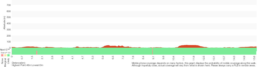
Analysis and summary of the altitude variation on the East Hills to Padstow along the Georges River
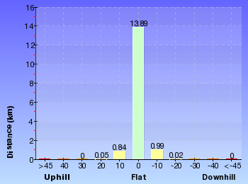
Overview of this walks grade – based on the AS 2156.1 – 2001
Under this standard, a walk is graded based on the most difficult section of the walk.
| Length | 15.8 km | ||
| Time | 5 hrs 30 mins | ||
| . | |||
| Grade 3/6 Moderate track |
AS 2156.1 | Gradient | Short steep hills (3/6) |
| Quality of track | Formed track, with some branches and other obstacles (3/6) | ||
| Signs | Directional signs along the way (3/6) | ||
| Experience Required | Some bushwalking experience recommended (3/6) | ||
| Weather | Weather generally has little impact on safety (1/6) | ||
| Infrastructure | Limited facilities, not all cliffs are fenced (3/6) |
Some more details of this walks Grading
Here is a bit more details explaining grading looking at sections of the walk
Gradient
9km of this walk is flat with no steps and another 6km has gentle hills with occasional steps. The remaining (1.1km) has short steep hills.
Quality of track
8km of this walk follows a smooth and hardened path and another 6km follows a formed track, with some branches and other obstacles. The remaining (1.9km) follows a clear and well formed track or trail.
Signs
Around 10km of this walk is clearly signposted, whilst the remaining 5km has directional signs at most intersection.
Experience Required
Around 11km of this walk requires no previous bushwalking experience, whilst the remaining 5km requires some bushwalking experience.
weather
This whole walk, 16km is not usually affected by severe weather events (that would unexpectedly impact safety and navigation).
Infrastructure
Around 13km of this walk is close to useful facilities (such as fenced cliffs and seats), whilst the remaining 2.3km has limited facilities (such as not all cliffs fenced).
Similar walks
A list of walks that share part of the track with the East Hills to Padstow along the Georges River walk.
566 m Return
15 mins
Very easy
769 m Circuit
30 mins
Moderate track
1 km Return
20 mins
Very easy
1.2 km One way
30 mins
Moderate track
1.3 km One way
30 mins
Very easy
1.8 km Circuit
45 mins
Moderate track
2.5 km One way
1 hr 15 mins
Moderate track
2.6 km One way
1 Hr
Moderate track
2.8 km One way
1 Hr
Moderate track
2.9 km Circuit
1 hr 15 mins
Hard track
4 km One way
1 hr 45 mins
Moderate track
4.3 km Return
1 hr 30 mins
Very easy
8 km One way
2 hrs 45 mins
Moderate track
Other Nearby walks
A list of walks that start near the East Hills to Padstow along the Georges River walk.
11 km One way
4 hrs
Hard track
5.8 km One way
2 hrs 30 mins
Hard track
918 m Return
20 mins
Very easy
10.1 km One way
5 hrs
Hard track
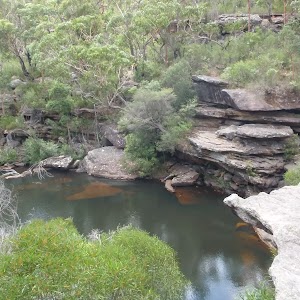
10.8 km One way
2 Days
Hard track
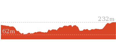
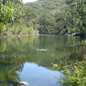
11 km Circuit
4 hrs
Hard track
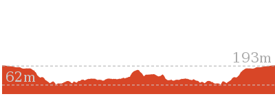
10 km One way
4 hrs 15 mins
Hard track
15 km One way
6 hrs 30 mins
Hard track
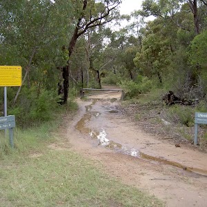
11.3 km One way
4 hrs 30 mins
Hard track
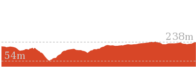
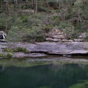
5.6 km Return
3 hrs
Moderate track
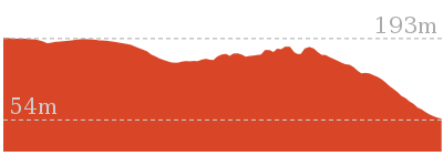
13.4 km One way
5 hrs
Hard track
2.2 km Return
45 mins
Easy track
Plan your trip to and from the walk here
The East Hills to Padstow along the Georges River walk starts at the East Hills Railway Station (gps: -33.961966, 150.98464)
Your transport options to East Hills Railway Station are by;
![]() Train. (get details)
Train. (get details)
![]() Bus. (get details)
Bus. (get details)
![]() Car. There is free parking available.
Car. There is free parking available.
(get details)
The East Hills to Padstow along the Georges River ends at the Padstow Railway Station (gps: -33.951899, 151.03197)
Your transport options to Padstow Railway Station are by;
![]() Train. (get details)
Train. (get details)
![]() Bus. (get details)
Bus. (get details)
![]() Car. There is free parking available.
Car. There is free parking available.
(get details)
Short URL = http://wild.tl/ehtpatgr
Gallery images
There are other downloads I am still working on.
You will probably need to login to access these — still all free.
* KML (google earth file)
* GPX (GPS file)
Special Maps/ brochures
* A3 topo maps
* PDF with Lands Topo map base
* PDF with arial image (and map overlay)
I wanted to get the main site live first, this extra stuff will come in time.
Happy walking
Matt 🙂
Comments