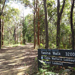
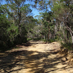
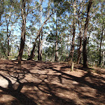
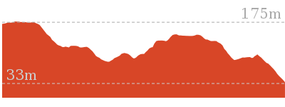
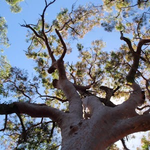
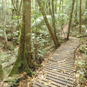
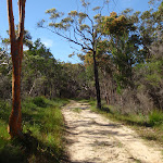
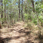
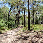
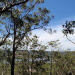
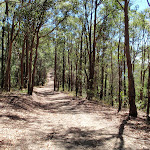
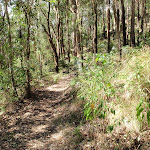
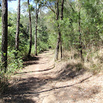
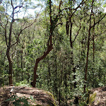
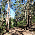
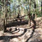
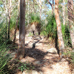
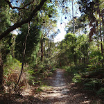
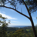
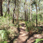
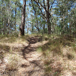
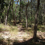
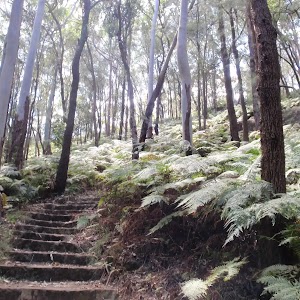
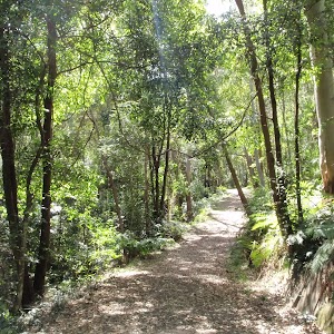
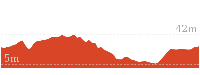
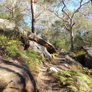
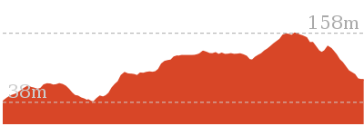
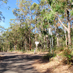
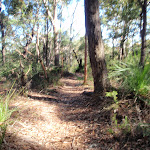
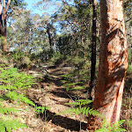
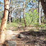
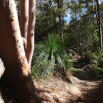
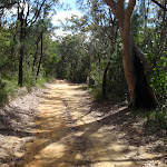
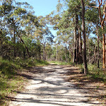
Yanina Walk is a gentle walk, exploring one of the ridges at the top of Kincumber Mountain. The walk follows a wide management trail from the main Honemans Picnic area, leading to the good views of Colin Watters Lookout. The notes describe a side trip to Nyari Lookout, but the views are very limited. The view from Colin Watters Lookout is arguably the best in the park, extending down Picketts Valley to Avoca Lake and Beach. There is a picnic table at the lookout, encouraging a snack before returning to the start.
Yanina Walk
And Walk
Yanina Walk


1 hr 15 mins
3.2 km Return

55 m
Easy track


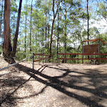
Honeman’s Rock picnic area
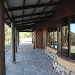
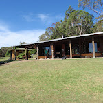
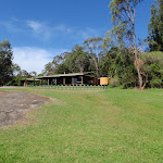
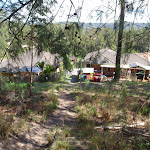
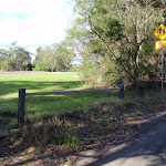
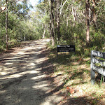
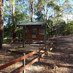
Honeman’s Rock picnic area is a large picnic area at the top end of Island View Drive. This picnic area has a couple of large grassy areas[1], composting toilets[2], free electric BBQs[3], picnic tables[4], shelters, garbage bins[5], drinking water[6] and information signs[7]. The picnic area is home to a mud brick building[8] (available for hire) and Honeman’s Rock[9], from which the area derives its name. There is a fair amount of parking available next the picnic area, and some extra spaces a few hundred meters down the road.
Honeman’s Rock
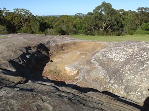
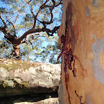
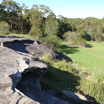
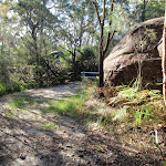
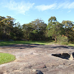
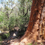
Honeman’s Rock (aka Honeyman’s Rock) is a large rock outcrop in front of the mud brick building, in the Honeman’s Rock Picnic area. The exposed section of rock is 60m long and about 30m wide, with the western side having a significant unfenced drop. The rock is named after Cecil Lyle Honeman who became a lease holder on the mountain in 1962. The rock has a large depression that once filled with water, and a drain has been dug to keep the pool empty and clear of rubbish.
Mud Brick Building

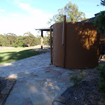
The mud brick building is a landmark in the main picnic area at Kincumber Mountain, and is a popular spot to gather. Also known as ‘Kincumber Mountain Information Centre’, ‘The Kiosk’, ‘Kincumber Kiosk’ and ‘Kincumber Mountain Kiosk’, the building was constructed in 1986 with funding from Community Employment Programme. The building is generally locked but can be booked through the local Lions Club for special events. The building has a rain water tank, small kitchen and one main large room. The verandah also provides good shelter.
(0km) Mudbrick building car park → End of Island View Dr

180 m
3 mins
7m
0m
Very easy
From the car park, this walk heads up the road, initially keeping the mud brick building to the left. Soon the road leads to an intersection (next to an information board and fence on the left).
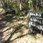
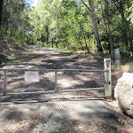
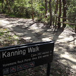
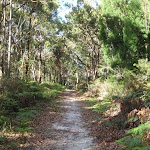
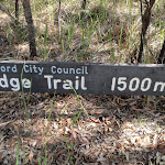
Continue straight: From the intersection, this walk follows the road up the hill, keeping the picnic area to the left and passing more car parks. The road bends a little, then comes to a large car park (on the left), a locked gate and a ‘Yanina Walk’ sign[13].
Continue straight: From the intersection, this walk follows the road up the hill, keeping the picnic area to the left and passing more car parks. The road bends a little, then comes to a large car park (on the left), a locked gate and a ‘Yanina Walk’ sign[13].
(0.18km) End of Island View Dr → Int of Kanning and Yanina walks
400 m
7 mins
6m
-9m
Easy track
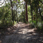
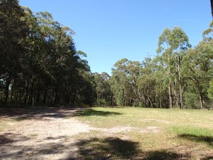
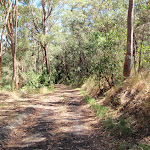
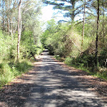
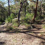
Continue straight: From the road, this walk heads around the locked gate and follows the ‘Yanina Walk – Colin Watters Lookout’ sign[14] along the wide trail. After about 50m, the trail passes a cottage (the house on the left) and as the trail bends to the right, it comes to an intersection with a link track on the left (just after the end of a short fence on the right).
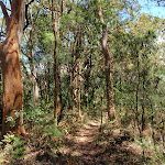
Continue straight: From the intersection, this walk follows the wide management trail, gently uphill away from the cottage and fence. After a few hundred metres, the trail passes a track and locked gate (on the right, which leads the roof of a cave) and continues along the wide trail for another 40m to a well-signposted intersection, with ‘Kanning Walk’ & ‘Mudbrick Building’ signs[15] pointing back along the trail.
Continue straight: From the intersection, this walk follows the wide management trail, gently uphill away from the cottage and fence. After a few hundred metres, the trail passes a track and locked gate (on the right, which leads the roof of a cave) and continues along the wide trail for another 40m to a well-signposted intersection, with ‘Kanning Walk’ & ‘Mudbrick Building’ signs[15] pointing back along the trail.
(0.58km) Int of Kanning and Yanina walks → Int of Nyari and Colin Watters lookout trails
750 m
13 mins
12m
-4m
Easy track
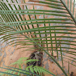
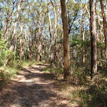
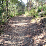
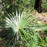
Continue straight: From the intersection, this walk heads north-east, following the ‘Yanina Walk’ sign[16] along the wide trail. The trail winds through the fern, palm and tall-wooded forest, passing a few small clearings on the side. The trail then comes to a clear, signposted ‘Y’ intersection with signs for ‘Colin Watters Lookout’ (leading right) and ‘Nyari Lookout’ (leading left)[17].
(1.33km) Int of Nyari and Colin Watters lookout trails → Tower clearing
150 m
3 mins
5m
0m
Easy track
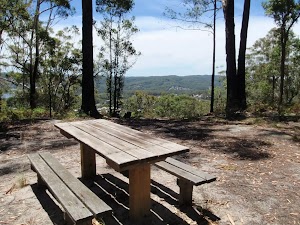
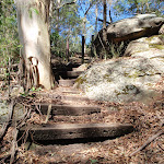
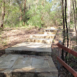
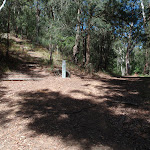
Continue straight: From the intersection, this walk follows the ‘Colin Watters Lookout’ sign[18] gently uphill. After about 80m, the trail opens up into a large clearing, which the walk continues through (passing a shortcut track on the right). The walk comes to an intersection near the far end of the clearing (just before the picnic table), marked with another ‘Colin Watters Lookout’ sign[19] (on the right).
(1.48km) Tower clearing → Nyari Lookout
130 m
3 mins
1m
-11m
Moderate track
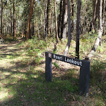
Turn left: From the intersection, this walk crosses the clearing (keeping the tower behind and to the right), then follows the ‘Nyari Lookout’ sign[22] back into the bush. The track gently winds through the ferns and soon comes to a ‘T’ intersection with a management trail, and ‘Nyari Lookout’ on the otherside side of the trail[23]. At the end of this side trip, retrace your steps back to the main walk then Continue straight.
Nyari Lookout
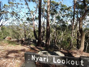
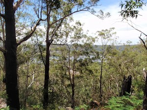
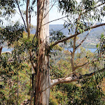
The signposted[24] and unfenced Nyari Lookout is found beside the Sandringham Trail and is also know as Nyari Point. The views from this point are filtered through the trees and extend north-west over Erina and a small section of the Brisbane Water to Rumbalara Reserve[26]. Not the greatest views around.
(1.48km) Tower clearing → Colin Watters Lookout
150 m
3 mins
0m
-12m
Easy track
Turn right: From the clearing, this walk follows the ‘Colin Watters Lookout’ sign[27] along the narrower management trail, keeping the tower through the trees on the left. The trail bends left, soon coming to another intersection.
Turn right: From the intersection, this walk heads east, directly away from the tower along the management trail, towards the sheltered information board. Soon after passing the information sign (and the shortcut track on the right), this walk continues down the trail to the fenced and signposted ‘Colin Watters Lookout’[28].
Turn right: From the intersection, this walk heads east, directly away from the tower along the management trail, towards the sheltered information board. Soon after passing the information sign (and the shortcut track on the right), this walk continues down the trail to the fenced and signposted ‘Colin Watters Lookout’[28].
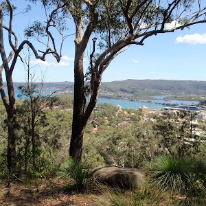
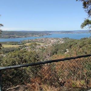
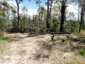
Colin Watters Lookout

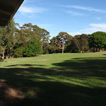
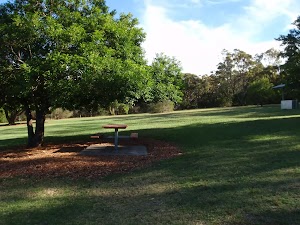
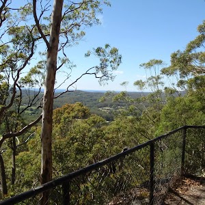
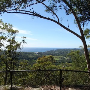
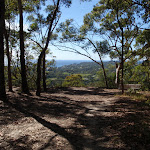
A plaque[29] explains that this lookout was named in 1992 in honour of the Colin D Watters, who was Senior Parks Supervisor with Gosford Council. The fenced[30] lookout provides great view south-east, down Picketts Valley to Avoca Lake and Beach[31]. The lookout is also home to an information board[32], bench seat[33], picnic table and garbage bin[34]. This lookout offers one of the best views in the park and makes a great spot to stop and rest.
Maps for the Yanina Walk walk
You can download the PDF for this walk to print a map.
These maps below cover the walk and the wider area around the walk, they are worth carrying for safety reasons.
| Gosford | 1:25 000 Map Series | 91312S GOSFORD | NSW-91312S |
| Gosford | 1:100 000 Map Series | 9131 GOSFORD | 9131 |
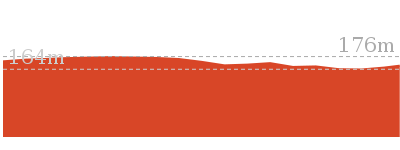
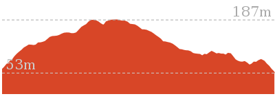
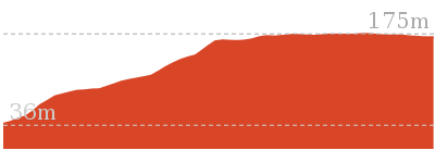
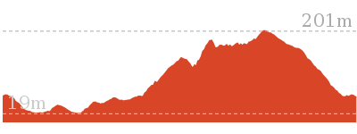
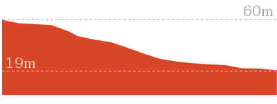
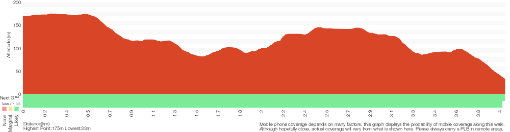
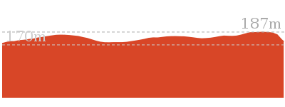
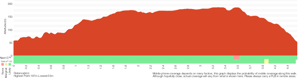
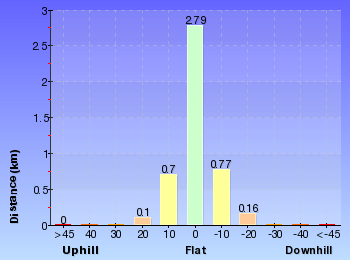
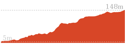
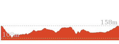
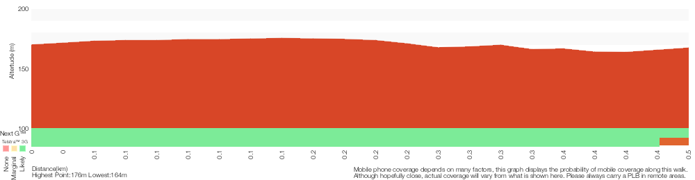
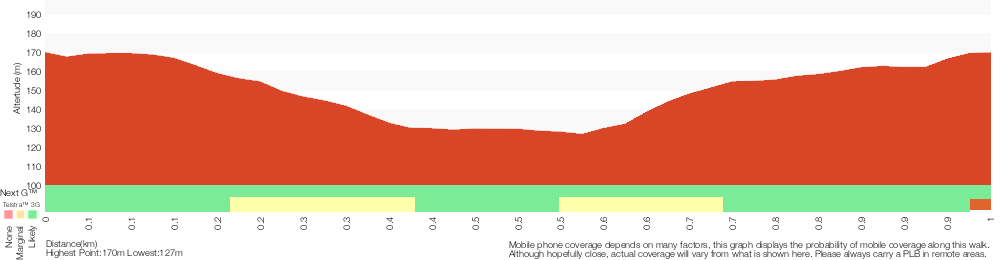
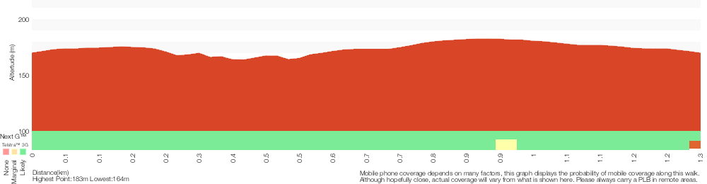
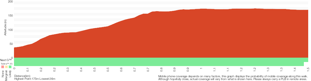
Cross sectional view of the Yanina Walk bushwalking track
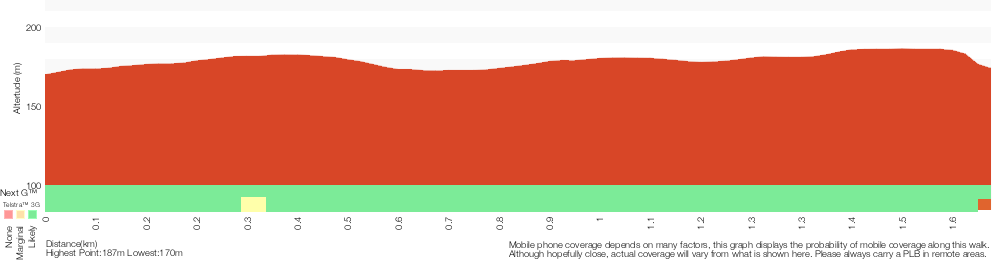
Analysis and summary of the altitude variation on the Yanina Walk
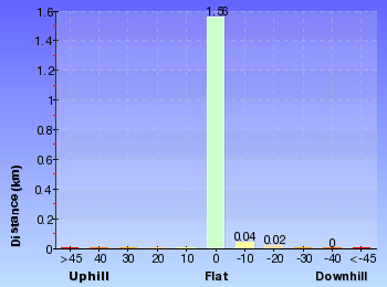
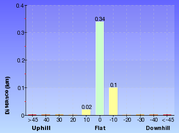
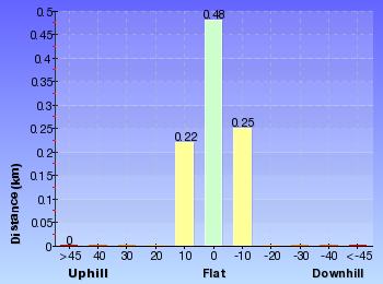
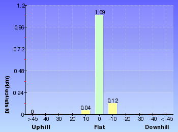
Overview of this walks grade – based on the AS 2156.1 – 2001
Under this standard, a walk is graded based on the most difficult section of the walk.
| Length | 3.2 km | ||
| Time | 1 hr 15 mins | ||
| . | |||
| Grade 2/6 Easy track |
AS 2156.1 | Gradient | Gentle hills with occasional steps (2/6) |
| Quality of track | Clear and well formed track or trail (2/6) | ||
| Signs | Clearly signposted (1/6) | ||
| Experience Required | No experience required (1/6) | ||
| Weather | Weather generally has little impact on safety (1/6) | ||
| Infrastructure | Generally useful facilities (such as fenced cliffs and seats) (1/6) |
Some more details of this walks Grading
Here is a bit more details explaining grading looking at sections of the walk
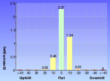
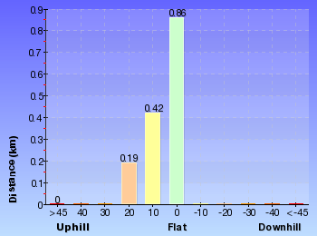
Gradient
Around 1.4km of this walk has gentle hills with occasional steps, whilst the remaining 180m is flat with no steps.
Quality of track
Around 1.4km of this walk follows a clear and well formed track or trail, whilst the remaining 180m follows a smooth and hardened path.
Signs
This whole walk, 1.6km is clearly signposted.
Experience Required
This whole walk, 1.6km requires no previous bushwalking experience.
weather
This whole walk, 1.6km is not usually affected by severe weather events (that would unexpectedly impact safety and navigation).
Infrastructure
This whole walk, 1.6km is close to useful facilities (such as fenced cliffs and seats).
Similar walks
A list of walks that share part of the track with the Yanina Walk walk.
922 m Return
20 mins
Easy track
1.3 km Circuit
30 mins
Easy track
2.9 km Circuit
1 hr 30 mins
Hard track

4.5 km One way
2 hrs
Hard track
Other Nearby walks
A list of walks that start near the Yanina Walk walk.

962 m Circuit
30 mins
Moderate track
4.1 km One way
1 hr 45 mins
Hard track
1.5 km Return
30 mins
Easy track

1.7 km One way
1 Hr
Moderate track
1.5 km One way
45 mins
Hard track

2.2 km Return
1 hr 15 mins
Hard track
5.3 km Circuit
2 hrs 45 mins
Moderate track
8.5 km One way
3 hrs 45 mins
Hard track

2 km Return
1 Hr
Moderate track
890 m Return
30 mins
Easy track
1.6 km Circuit
45 mins
Easy track

3 km Return
1 hr 30 mins
Hard track
Plan your trip to and from the walk here
The Yanina Walk walk starts and ends at the Mudbrick building car park (gps: -33.459135, 151.39183)
Your main transport option to Mudbrick building car park is by;
![]() Car. There is free parking available.
Car. There is free parking available.
(get details)


Short URL = http://wild.tl/yw
Gallery images
There are other downloads I am still working on.
You will probably need to login to access these — still all free.
* KML (google earth file)
* GPX (GPS file)
Special Maps/ brochures
* A3 topo maps
* PDF with Lands Topo map base
* PDF with arial image (and map overlay)
I wanted to get the main site live first, this extra stuff will come in time.
Happy walking
Matt 🙂
Sid Pulsford Walk
And Walk
Sid Pulsford Walk

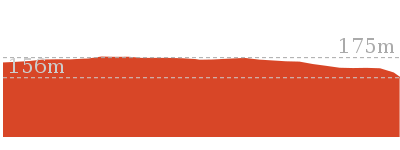
1 hr 45 mins
4.1 km One way
118 m
Hard track
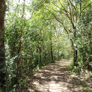
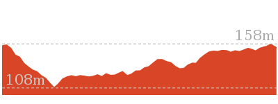
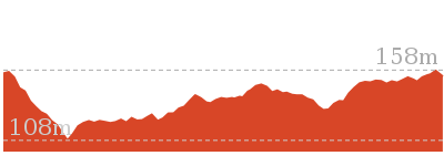
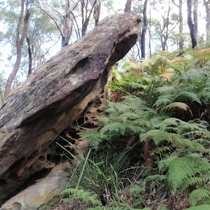
Sid Pulsford Walk explores the ridge top of Kincumber Mountain, from Honeman’s Rock to Green Point. The walk mostly follows wide management trails. Halfway along the walk, you will find the By-Pass lookout and rest area, providing good views and a great place to rest. The walk leads past the water reservoir above Green Point, then down the driveway to the end of Beatties Rd.


Honeman’s Rock picnic area
Honeman’s Rock picnic area is a large picnic area at the top end of Island View Drive. This picnic area has a couple of large grassy areas[1], composting toilets[2], free electric BBQs[3], picnic tables[4], shelters, garbage bins[5], drinking water[6] and information signs[7]. The picnic area is home to a mud brick building[8] (available for hire) and Honeman’s Rock[9], from which the area derives its name. There is a fair amount of parking available next the picnic area, and some extra spaces a few hundred meters down the road.
Mud Brick Building
The mud brick building is a landmark in the main picnic area at Kincumber Mountain, and is a popular spot to gather. Also known as ‘Kincumber Mountain Information Centre’, ‘The Kiosk’, ‘Kincumber Kiosk’ and ‘Kincumber Mountain Kiosk’, the building was constructed in 1986 with funding from Community Employment Programme. The building is generally locked but can be booked through the local Lions Club for special events. The building has a rain water tank, small kitchen and one main large room. The verandah also provides good shelter.
Honeman’s Rock
Honeman’s Rock (aka Honeyman’s Rock) is a large rock outcrop in front of the mud brick building, in the Honeman’s Rock Picnic area. The exposed section of rock is 60m long and about 30m wide, with the western side having a significant unfenced drop. The rock is named after Cecil Lyle Honeman who became a lease holder on the mountain in 1962. The rock has a large depression that once filled with water, and a drain has been dug to keep the pool empty and clear of rubbish.
(0km) Mudbrick building car park → Northern end of picnic area
180 m
3 mins
4m
-1m
Easy track
From the car park next to the mud brick building, this walk heads in front of the mud brick building and follows the path to the toilet block. Here, the walk heads across the grass between the picnic table (under the tree on the left) and the BBQ shelter (on the right) to the far end of the clearing, near another picnic table, to find the ‘Sid Pulsford Walking Trail’ sign[13].
(0.18km) Northern end of picnic area → Int of Sid Pulsford Walking and Warriwarri Lookout trails
290 m
5 mins
5m
-4m
Easy track
Continue straight: From the picnic area, this walk follows the ‘Sid Pulsford Walking Trail’ sign[14] around the locked gate and away from the clearing. The walk gently winds through the bush along the wide sandy trail, and comes to an intersection with a link track (heading up to the right) just after a large angophora.
Continue straight: From the intersection, this walk follows the wide management trail north, past the large twisted angophora, coming to the ‘Y’ intersection marked by two signs[15] (just visible from the previous intersection).
Continue straight: From the intersection, this walk follows the wide management trail north, past the large twisted angophora, coming to the ‘Y’ intersection marked by two signs[15] (just visible from the previous intersection).
(0.48km) Int of Sid Pulsford Walking and Warriwarri Lookout trails → Int of Sid Pulsford Walking trail and track
1.3 km
27 mins
28m
-100m
Hard track
Turn left: From the intersection, this walk follows the ‘Sid Pulsford Walking Trail’ sign[16] west along the wide trail, down the hill. The trail winds fairly gently down through the wooded and ferny forest and after about 230m, the trail steepens for a short distance. The walk continues down until passing another trail (leading back to the left) and crossing a wide saddle. On the other side of the saddle, the trail heads down steeply again and then up a hill, coming to an intersection with a track (on the left – this is just before the trail starts heading steeply downhill again).
(1.77km) Int of Sid Pulsford Walking trail and track → Sid Pulsford Saddle intersection
180 m
4 mins
4m
-12m
Hard track
Continue straight: From the intersection, this walk follows the track south-west as it immediately bends right, heading over the small rise and then down the hill. The track then leads to a clearing on a saddle with a four-way intersection, and a ‘By-pass’ sign[17].
(1.95km) Sid Pulsford Saddle intersection → Int of Sid Pulsford walking trail and rest area trail
780 m
18 mins
75m
-26m
Hard track
Turn left: From the intersection, this walk passes the ‘By-pass’ and ‘Rest Area 200m’ signs[18] (keeping them on the right) and follows the wide management trail south downhill. The trail winds down the hill to cross a valley with tall trees and some palms. The trail then climbs steeply out of the valley and as the trail flattens out, it passes two other trails (on the left) and then comes to another intersection on the right, near the top of the ridge, just before a large area of bracken ferns. Now Continue straight to rejoin the main walk .
(1.95km) Sid Pulsford Saddle intersection → By-pass rest area
330 m
9 mins
41m
-4m
Hard track
Continue straight: From the intersection, this walk follows the ‘By-pass’ and ‘Rest Area 200m’ signs[19] along the track, south-west up the ridge. The track soon comes to a rocky outcrop where it heads to the right (offering filtered views to the right). The track then heads around the side of the hill, up a couple of sets of timber steps, then turns right at the top of the ridge (at the arrow marker) and continues about 30m to the rest area, picnic table and views (to the right).
By-pass rest area
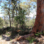
This lookout and rest area is not formally named and is found on a short by-pass track from the Sid Pulsford Trail. At this point on top of the hill, there is a picnic table[20] in a clearing and views north over Erina to Rumbalara and Katandra Reserves[21]. There is some natural shade, making this a good place for a rest.
(2.28km) By-pass rest area → Int of Sid Pulsford walking trail and rest area trail
260 m
6 mins
16m
-4m
Hard track
Continue straight: From the rest area, this walk heads west along the wider trail (keeping the main view to the right). The trail winds along the top of the ridge and turns left, coming to a ‘T’ intersection with another management trail in a fern-filled area.
(2.55km) Int of Sid Pulsford walking trail and rest area trail → Sid Pulsford walk lookout intersection
560 m
10 mins
4m
-21m
Hard track
Turn right: From the intersection, this walk follows the wide management trail north-west along the top of the ridge, initially keeping the valley to the left. After about 200m, the trail crosses a clearing and rock platform (with some filtered view to the right). The trail then leads downhill along the ridge to a ‘Y’ intersection with the signposted ‘Lookout 100m’ track[22] (on the right).
(3.11km) Sid Pulsford walk lookout intersection → Sid Pulsford walk lookout
50 m
1 mins
1m
-5m
Moderate track
Turn right: From the intersection, this walk follows the ‘Lookout 100m’ sign[23] up the small rise and along the old management trail. The trail bends left and comes to a clearing with filtered views over Green Point. At the end of this side trip, retrace your steps back to the main walk then Turn right.
Sid Pulsford Walk lookout
(3.11km) Sid Pulsford walk lookout intersection → Top of Woorara fire trail
200 m
5 mins
0m
-37m
Hard track
Continue straight: From the intersection, this walk heads west downhill along the wide management trail, quite steeply at first. The now gravelly trail passes a rusty car (on the right) and then comes to clear ‘Y’ intersection.
(3.3km) Top of Woorara fire trail → End of Woorara Pde
310 m
7 mins
0m
-46m
Hard track
Veer right: From the intersection, this walk follows the lower trail that heads down towards the water view (keeping the other trail above and to the left). The trail heads steeply for a while then flattens out a little, before passing around a locked gate and coming to the end of Woorara Pde.
(3.3km) Top of Woorara fire trail → Water Tank
360 m
7 mins
16m
-6m
Moderate track
Veer left: From the intersection, this walk heads south-west along the wide ridge-top trail, keeping the steeper trail below to the right. The walk then heads down a gentle hill then up the other side, enjoying water glimpses on either side. When in view of the water tank, the trail heads left then down the hill to come to a large clearing and the water tank.
(3.66km) Water Tank → End of Beatties Rd
390 m
9 mins
0m
-66m
Hard track
Veer left: From the clearing, this walk follows the power lines around the water tanks (keeping the tank on the right). The walk then turns left and follows the driveway (and power lines) down the hill, quite steeply for a while. The walk then heads around the locked gate, coming to the end of Beatties Rd, Green Point.
Maps for the Sid Pulsford Walk walk
You can download the PDF for this walk to print a map.
These maps below cover the walk and the wider area around the walk, they are worth carrying for safety reasons.
| Gosford | 1:25 000 Map Series | 91312S GOSFORD | NSW-91312S |
| Gosford | 1:100 000 Map Series | 9131 GOSFORD | 9131 |
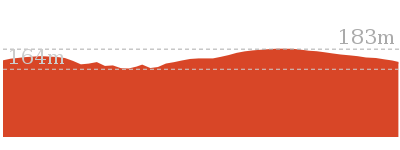
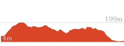
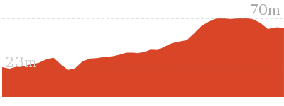
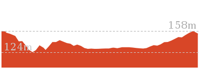
Cross sectional view of the Sid Pulsford Walk bushwalking track
Analysis and summary of the altitude variation on the Sid Pulsford Walk
Overview of this walks grade – based on the AS 2156.1 – 2001
Under this standard, a walk is graded based on the most difficult section of the walk.
| Length | 4.1 km | ||
| Time | 1 hr 45 mins | ||
| . | |||
| Grade 4/6 Hard track |
AS 2156.1 | Gradient | Very steep (4/6) |
| Quality of track | Clear and well formed track or trail (2/6) | ||
| Signs | Minimal directional signs (4/6) | ||
| Experience Required | Some bushwalking experience recommended (3/6) | ||
| Weather | Weather generally has little impact on safety (1/6) | ||
| Infrastructure | Generally useful facilities (such as fenced cliffs and seats) (1/6) |
Some more details of this walks Grading
Here is a bit more details explaining grading looking at sections of the walk
Gradient
1.9km of this walk is very steep and another 1.7km has short steep hills. Whilst another 290m has gentle hills with occasional steps and the remaining 180m is flat with no steps.
Quality of track
This whole walk, 4.1km follows a clear and well formed track or trail.
Signs
2.8km of this walk has minimal directional signs and another 750m has directional signs at most intersection. The remaining (480m) is clearly signposted.
Experience Required
Around 3.6km of this walk requires some bushwalking experience, whilst the remaining 480m requires no previous bushwalking experience.
weather
This whole walk, 4.1km is not usually affected by severe weather events (that would unexpectedly impact safety and navigation).
Infrastructure
This whole walk, 4.1km is close to useful facilities (such as fenced cliffs and seats).
Similar walks
A list of walks that share part of the track with the Sid Pulsford Walk walk.
1.5 km One way
45 mins
Hard track
1.5 km Return
30 mins
Easy track
Other Nearby walks
A list of walks that start near the Sid Pulsford Walk walk.
962 m Circuit
30 mins
Moderate track
922 m Return
20 mins
Easy track
1.3 km Circuit
30 mins
Easy track
3.2 km Return
1 hr 15 mins
Easy track
1.7 km One way
1 Hr
Moderate track
4.5 km One way
2 hrs
Hard track
2.9 km Circuit
1 hr 30 mins
Hard track
2.2 km Return
1 hr 15 mins
Hard track
5.3 km Circuit
2 hrs 45 mins
Moderate track
8.5 km One way
3 hrs 45 mins
Hard track
2 km Return
1 Hr
Moderate track
890 m Return
30 mins
Easy track
Plan your trip to and from the walk here
The Sid Pulsford Walk walk starts at the Mudbrick building car park (gps: -33.459138, 151.39182)
Your main transport option to Mudbrick building car park is by;
![]() Car. There is free parking available.
Car. There is free parking available.
(get details)
The Sid Pulsford Walk ends at the End of Beatties Rd (gps: -33.45887, 151.36193)
Your transport options to End of Beatties Rd are by;
![]() Bus. (get details)
Bus. (get details)
![]() Car. There is free parking available.
Car. There is free parking available.
(get details)
Short URL = http://wild.tl/spw
Gallery images
There are other downloads I am still working on.
You will probably need to login to access these — still all free.
* KML (google earth file)
* GPX (GPS file)
Special Maps/ brochures
* A3 topo maps
* PDF with Lands Topo map base
* PDF with arial image (and map overlay)
I wanted to get the main site live first, this extra stuff will come in time.
Happy walking
Matt 🙂
Kincumber to Terrigal (via Glasson’s Trl)

2 hrs
4.5 km One way
220 m
Hard track
This walk explores the main highlights of Kincumber Mountain Regional Reserve. Starting on the Glasson’s trail, the walk explores a variety of forests along the way to Honeman’s Rock and picnic area. After a rest, you visit a large cave on Kanning Walk and continue to the views at Colin Watters Lookout. You then follow a track down the ridge, passing some interesting rocky outcrops before arriving at the end of Sandringham Close, Terrigal.


(0km) Glasson’s Car Park → Glasson’s crossing
970 m
25 mins
84m
-38m
Moderate track
From the car park (about 230m from the end of Kincumber St past the ‘Kincumber Mountain Regional Reserve’ sign[1]), this walk heads to the back of the car park, through the gap in the fence and turns right. The walk follows the track, keeping the water tank up the hill to the right. The walk leads up some timber steps through the rocks and, soon after passing the water tank, the track comes to a ‘T’ intersection with a management trail.
Veer left: From the intersection, this walk follows the wide management trail away from the water tank and gently down the hill, keeping the valley to the left. The trail meanders through the bush for about 300m, rounding a wide sweeping right-hand bend – during this bend, the walk comes to a rocky outcrop with a view into the valley (on the left). From here, the walk continues around the bend and up the hill. As the walk enters a more lush section of forest, the trail becomes narrower for a while. The trail then begins to climb again as it widens back out, before coming to a locked gate and road. The walk crosses the road, coming to a small clearing on the other side.
Veer left: From the intersection, this walk follows the wide management trail away from the water tank and gently down the hill, keeping the valley to the left. The trail meanders through the bush for about 300m, rounding a wide sweeping right-hand bend – during this bend, the walk comes to a rocky outcrop with a view into the valley (on the left). From here, the walk continues around the bend and up the hill. As the walk enters a more lush section of forest, the trail becomes narrower for a while. The trail then begins to climb again as it widens back out, before coming to a locked gate and road. The walk crosses the road, coming to a small clearing on the other side.
(0.97km) Glasson’s crossing → Bottom of Overflow car park
490 m
12 mins
46m
-6m
Moderate track
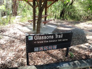
Continue straight: From the clearing, this walk heads up the ramp behind the clearing, keeping the road to the left. The track leads up the timber steps, between the timber posts and turns right, heading up more steps. The rocky track flattens out somewhat and heads along the top of the ridge, among the grass trees and angophora forest, where the track then leads down the hill to the road. At the road, the walk turns right to follow the road for about 10m, then turns left and follows the track back into the bush (now with the road to the right). This track gently meanders for almost 100m before coming to the bottom of a car park, a picnic shelter and a ‘Glasson’s Trail – Island View Entrance 1300 metres’ sign[2] pointing back down the track.
Glasson’s Trail Picnic Area
At the lower end of the overflow car park, near the top of Glasson’s Trail, is a single picnic table and shelter[3]. There are no other facilities here. A short distance from the main picnic area, this is an alternative spot for those wanting a picnic table amongst more native trees.
(1.46km) Bottom of Overflow car park → Mudbrick building car park
240 m
7 mins
28m
0m
Easy track
Continue straight: From the picnic shelter, this walk heads uphill across the car park to another ‘Glasson’s Trail’[4] sign, at the base of the stone steps.
Veer left: From the top of the car park, this walk follows the ‘Glassons Trail – Honemans Rock picnic area’ sign[5] up the stone steps. The track follows the footpath for a short time before coming to a large clearing and another ‘Glassons Trail’ sign[6] pointing back down to the car park. From here, the walk heads across the grassy area, bending to the right around the rock to come to the end of Honeman’s rock (on the left) and a gate (on the right) (just in view of the mud brick building).
Continue straight: From Honeman’s rock, this walk heads up the hill over the grassy clearing to the front of the mud brick building and the car park on the right.
Mud Brick Building
The mud brick building is a landmark in the main picnic area at Kincumber Mountain, and is a popular spot to gather. Also known as ‘Kincumber Mountain Information Centre’, ‘The Kiosk’, ‘Kincumber Kiosk’ and ‘Kincumber Mountain Kiosk’, the building was constructed in 1986 with funding from Community Employment Programme. The building is generally locked but can be booked through the local Lions Club for special events. The building has a rain water tank, small kitchen and one main large room. The verandah also provides good shelter.
Honeman’s Rock picnic area
Honeman’s Rock picnic area is a large picnic area at the top end of Island View Drive. This picnic area has a couple of large grassy areas[9], composting toilets[10], free electric BBQs[11], picnic tables[12], shelters, garbage bins[13], drinking water[14] and information signs[15]. The picnic area is home to a mud brick building[16] (available for hire) and Honeman’s Rock[17], from which the area derives its name. There is a fair amount of parking available next the picnic area, and some extra spaces a few hundred meters down the road.
Honeman’s Rock
Honeman’s Rock (aka Honeyman’s Rock) is a large rock outcrop in front of the mud brick building, in the Honeman’s Rock Picnic area. The exposed section of rock is 60m long and about 30m wide, with the western side having a significant unfenced drop. The rock is named after Cecil Lyle Honeman who became a lease holder on the mountain in 1962. The rock has a large depression that once filled with water, and a drain has been dug to keep the pool empty and clear of rubbish.
(1.7km) Mudbrick building car park → Kanning Walk gate
90 m
1 mins
5m
0m
Very easy
Turn left: From the car park, this walk heads up the road, initially keeping the mud brick building to the left. Soon the road leads to an intersection (next to an information board and fence on the left).
Turn right: From the intersection, this walk follows the ‘One Way’ road sign[19] away from the picnic area and along the road. Almost immediately, there is a locked gate and the ‘Kanning Walk’ sign[20] (on the left).
Turn right: From the intersection, this walk follows the ‘One Way’ road sign[19] away from the picnic area and along the road. Almost immediately, there is a locked gate and the ‘Kanning Walk’ sign[20] (on the left).
(1.79km) Kanning Walk gate → Cave
370 m
7 mins
11m
-18m
Easy track
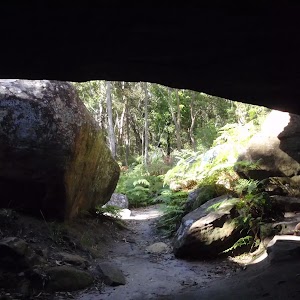
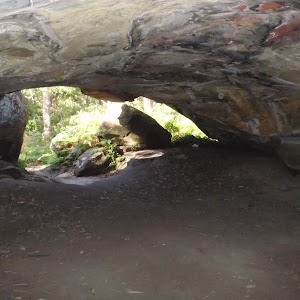
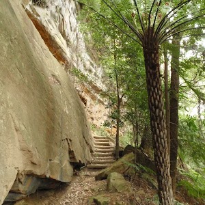
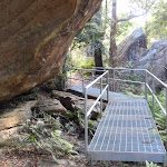
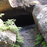
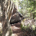
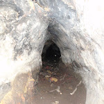
Turn left: From the road, this walk follows the ‘Kanning Walk cave 300 metres’ sign[21] around the locked gate and along the old sandy management trail. After about 120m the walk turns right, following another ‘Kanning Walk’ sign[22], and passes between two large, exposed tree root systems. Soon after this, the track is concrete for a short distance and passes along the base of a long rock wall. The walk goes down some steel stairs and across a timber bridge, coming to a sandstone overhang cave. This cave is quite large and has a ‘cave 100m’ sign[23], pointing further along the track. Follow this sign for about 150m, passing over a steel platform, up a small rise and down some steel stairs. From the base of these stairs, the walk continues for about 25m along the flat track to find the unsignposted entrance to the cave. The entrance is between two large boulders on the left[24].
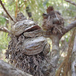
Kanning Walk Cave
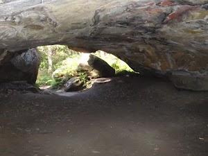
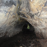
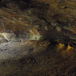
The main cave on Kanning Walk is surprising large for a sandstone environment. The cave has two main sections. There is a large cabin about 7m wide and 9m deep. A small tunnel extends about 10m further to a small chamber at the back. The entrance to the cave is behind two large boulders, providing extra shelter. It is believed that A. A. Glasson lived in the cave in the early 1930’s, which was not uncommon during the depression. The cave has proved to be a great place to rest on hot days.
(2.16km) Cave → Int of Kanning and Yanina walks
220 m
5 mins
13m
-7m
Easy track
Continue straight: From the entrance to the cave, this walk follows the track around the base of the rock wall, keeping the rock to the left. Soon the track passes (and follows) an ‘Alternate Return’ sign[26] then leads up some timber steps. The track soon flattens out and heads through a timber barrier, coming to a ‘T’ intersection with a wide management trail, and a few ‘Kanning Walk’ signs[27].
(2.38km) Int of Kanning and Yanina walks → Int of Nyari and Colin Watters lookout trails
750 m
13 mins
12m
-4m
Easy track
Turn right: From the intersection, this walk heads north-east, following the ‘Yanina Walk’ sign[28] along the wide trail. The trail winds through the fern, palm and tall-wooded forest, passing a few small clearings on the side. The trail then comes to a clear, signposted ‘Y’ intersection with signs for ‘Colin Watters Lookout’ (leading right) and ‘Nyari Lookout’ (leading left)[29].
(3.13km) Int of Nyari and Colin Watters lookout trails → Tower clearing
150 m
3 mins
5m
0m
Easy track
Continue straight: From the intersection, this walk follows the ‘Colin Watters Lookout’ sign[30] gently uphill. After about 80m, the trail opens up into a large clearing, which the walk continues through (passing a shortcut track on the right). The walk comes to an intersection near the far end of the clearing (just before the picnic table), marked with another ‘Colin Watters Lookout’ sign[31] (on the right).
(3.27km) Tower clearing → Colin Watters Lookout
150 m
3 mins
0m
-12m
Easy track
Turn right: From the clearing, this walk follows the ‘Colin Watters Lookout’ sign[34] along the narrower management trail, keeping the tower through the trees on the left. The trail bends left, soon coming to another intersection.
Turn right: From the intersection, this walk heads east, directly away from the tower along the management trail, towards the sheltered information board. Soon after passing the information sign (and the shortcut track on the right), this walk continues down the trail to the fenced and signposted ‘Colin Watters Lookout’[35].
Turn right: From the intersection, this walk heads east, directly away from the tower along the management trail, towards the sheltered information board. Soon after passing the information sign (and the shortcut track on the right), this walk continues down the trail to the fenced and signposted ‘Colin Watters Lookout’[35].
Colin Watters Lookout
A plaque[36] explains that this lookout was named in 1992 in honour of the Colin D Watters, who was Senior Parks Supervisor with Gosford Council. The fenced[37] lookout provides great view south-east, down Picketts Valley to Avoca Lake and Beach[38]. The lookout is also home to an information board[39], bench seat[40], picnic table and garbage bin[41]. This lookout offers one of the best views in the park and makes a great spot to stop and rest.
(3.42km) Colin Watters Lookout → Sandringham Track clearing
290 m
9 mins
12m
-30m
Hard track
Turn left: From the lookout, this walk follows the narrower track, initially keeping the view and fence on the right. The track soon bends left and passes and informal track (on the right), coming to a clear intersection with a wider trail near the large tower.
Turn right: From the intersection, this walk heads north-east away from the tower (keeping it behind and to the left), moving towards the rocky outcrop. The track passes the rocks and continues along the flat section to a larger rocky outcrop. Here, the walk keeps the rocks to the left, following the track between the gums and grass trees, with filtered views to the right. Keeping near the top of the ridge, the track continues down past the rock to a small clearing and intersection with a management trail.
Turn right: From the intersection, this walk heads north-east away from the tower (keeping it behind and to the left), moving towards the rocky outcrop. The track passes the rocks and continues along the flat section to a larger rocky outcrop. Here, the walk keeps the rocks to the left, following the track between the gums and grass trees, with filtered views to the right. Keeping near the top of the ridge, the track continues down past the rock to a small clearing and intersection with a management trail.
(3.7km) Sandringham Track clearing → Sandringham intersection
690 m
18 mins
4m
-70m
Hard track
Veer right: From the intersection, this walk follows the narrow track downhill along the top of the ridge, initially keeping the management trail down to the left. After about 120m, this walk takes the right-hand fork at a ‘Y’ intersection and, another 150m later, turns right again in front of the large, dead tree. The track leads down a few steps and across a flat saddle for a short time. The track then turns left and heads down a long series of timber steps, coming to a wide management trail at a five-way intersection.
(4.39km) Sandringham intersection → End of Sandringham Cl
140 m
4 mins
0m
-33m
Moderate track
Turn left: From the intersection, this walk follows the narrower track downhill between the timber barriers, towards the houses. The track leads down a series of timber steps and then down a concrete path (and steps) between two houses, coming to the end of Sandringham Cl.
Maps for the Kincumber to Terrigal (via Glasson’s Trl) walk
You can download the PDF for this walk to print a map.
These maps below cover the walk and the wider area around the walk, they are worth carrying for safety reasons.
| Gosford | 1:25 000 Map Series | 91312S GOSFORD | NSW-91312S |
| Gosford | 1:100 000 Map Series | 9131 GOSFORD | 9131 |
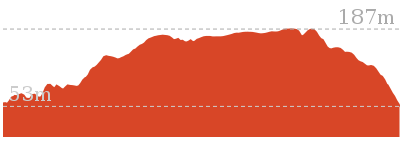
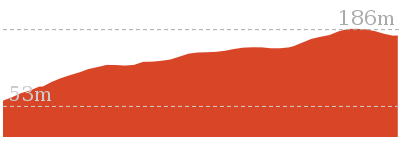
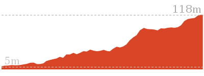
Cross sectional view of the Kincumber to Terrigal (via Glasson’s Trl) bushwalking track
Analysis and summary of the altitude variation on the Kincumber to Terrigal (via Glasson’s Trl)
Overview of this walks grade – based on the AS 2156.1 – 2001
Under this standard, a walk is graded based on the most difficult section of the walk.
| Length | 4.5 km | ||
| Time | 2 hrs | ||
| . | |||
| Grade 4/6 Hard track |
AS 2156.1 | Gradient | Very steep (4/6) |
| Quality of track | Formed track, with some branches and other obstacles (3/6) | ||
| Signs | Minimal directional signs (4/6) | ||
| Experience Required | Moderate level of bushwalking experience recommended (4/6) | ||
| Weather | Weather generally has little impact on safety (1/6) | ||
| Infrastructure | Generally useful facilities (such as fenced cliffs and seats) (1/6) |
Some more details of this walks Grading
Here is a bit more details explaining grading looking at sections of the walk
Gradient
2.7km of this walk has gentle hills with occasional steps and another 860m is very steep. Whilst another 780m has short steep hills and the remaining 140m is flat with no steps.
Quality of track
2.6km of this walk follows a clear and well formed track or trail and another 1.6km follows a formed track, with some branches and other obstacles. The remaining (270m) follows a smooth and hardened path.
Signs
3.4km of this walk is clearly signposted and another 940m has directional signs at most intersection. The remaining (170m) has minimal directional signs.
Experience Required
3.4km of this walk requires no previous bushwalking experience and another 940m requires some bushwalking experience. The remaining (170m) requires a leader a with moderate level of bushwalking experience.
weather
This whole walk, 4.5km is not usually affected by severe weather events (that would unexpectedly impact safety and navigation).
Infrastructure
This whole walk, 4.5km is close to useful facilities (such as fenced cliffs and seats).
Similar walks
A list of walks that share part of the track with the Kincumber to Terrigal (via Glasson’s Trl) walk.
922 m Return
20 mins
Easy track
962 m Circuit
30 mins
Moderate track
1.3 km Circuit
30 mins
Easy track
1.7 km One way
1 Hr
Moderate track
2.2 km Return
1 hr 15 mins
Hard track
2.9 km Circuit
1 hr 30 mins
Hard track
3.2 km Return
1 hr 15 mins
Easy track
Other Nearby walks
A list of walks that start near the Kincumber to Terrigal (via Glasson’s Trl) walk.
4.1 km One way
1 hr 45 mins
Hard track
1.5 km Return
30 mins
Easy track
1.5 km One way
45 mins
Hard track
3 km Return
1 hr 30 mins
Hard track
2.2 km One way
1 Hr
Hard track
991 m One way
30 mins
Moderate track
1.7 km Circuit
45 mins
Moderate track
1.6 km Circuit
45 mins
Moderate track

2.1 km Circuit
1 Hr
Moderate track
3.3 km Circuit
1 hr 30 mins
Hard track
1.4 km Circuit
45 mins
Hard track
3 km One way
1 hr 30 mins
Hard track
Plan your trip to and from the walk here
The Kincumber to Terrigal (via Glasson’s Trl) walk starts at the Glasson’s Car Park (gps: -33.463707, 151.37924)
Your transport options to Glasson’s Car Park are by;
![]() Bus. (get details)
Bus. (get details)
![]() Car. There is free parking available.
Car. There is free parking available.
(get details)
The Kincumber to Terrigal (via Glasson’s Trl) ends at the End of Sandringham Cl (gps: -33.444669, 151.40678)
Your transport options to End of Sandringham Cl are by;
![]() Bus. (get details)
Bus. (get details)
![]() Car. There is free parking available.
Car. There is free parking available.
(get details)
Short URL = http://wild.tl/kttgtacwl
Gallery images
There are other downloads I am still working on.
You will probably need to login to access these — still all free.
* KML (google earth file)
* GPX (GPS file)
Special Maps/ brochures
* A3 topo maps
* PDF with Lands Topo map base
* PDF with arial image (and map overlay)
I wanted to get the main site live first, this extra stuff will come in time.
Happy walking
Matt 🙂
Kanning Cave Walk
And Walk
Kanning Cave Walk

20 mins
922 m Return
34 m
Easy track
This short walk follows a clear track to a large sandstone cave on the Kanning Walk. From the Honeman’s Picnic Area, follow Kanning Walk through the bush and along the side of a long rock wall. There are several caves along the way, the main one being quiet large and tucked behind some large boulders. The cave provides a cool spot on hot days. After admiring the cave, walk back the same way, passing some large angophora trees.


Honeman’s Rock picnic area
Honeman’s Rock picnic area is a large picnic area at the top end of Island View Drive. This picnic area has a couple of large grassy areas[1], composting toilets[2], free electric BBQs[3], picnic tables[4], shelters, garbage bins[5], drinking water[6] and information signs[7]. The picnic area is home to a mud brick building[8] (available for hire) and Honeman’s Rock[9], from which the area derives its name. There is a fair amount of parking available next the picnic area, and some extra spaces a few hundred meters down the road.
Honeman’s Rock
Honeman’s Rock (aka Honeyman’s Rock) is a large rock outcrop in front of the mud brick building, in the Honeman’s Rock Picnic area. The exposed section of rock is 60m long and about 30m wide, with the western side having a significant unfenced drop. The rock is named after Cecil Lyle Honeman who became a lease holder on the mountain in 1962. The rock has a large depression that once filled with water, and a drain has been dug to keep the pool empty and clear of rubbish.
Mud Brick Building
The mud brick building is a landmark in the main picnic area at Kincumber Mountain, and is a popular spot to gather. Also known as ‘Kincumber Mountain Information Centre’, ‘The Kiosk’, ‘Kincumber Kiosk’ and ‘Kincumber Mountain Kiosk’, the building was constructed in 1986 with funding from Community Employment Programme. The building is generally locked but can be booked through the local Lions Club for special events. The building has a rain water tank, small kitchen and one main large room. The verandah also provides good shelter.
(0km) Mudbrick building car park → Kanning Walk gate
90 m
1 mins
5m
0m
Very easy
From the car park, this walk heads up the road, initially keeping the mud brick building to the left. Soon the road leads to an intersection (next to an information board and fence on the left).
Turn right: From the intersection, this walk follows the ‘One Way’ road sign[13] away from the picnic area and along the road. Almost immediately, there is a locked gate and the ‘Kanning Walk’ sign[14] (on the left).
Turn right: From the intersection, this walk follows the ‘One Way’ road sign[13] away from the picnic area and along the road. Almost immediately, there is a locked gate and the ‘Kanning Walk’ sign[14] (on the left).
(0.09km) Kanning Walk gate → Cave
370 m
7 mins
11m
-18m
Easy track
Turn left: From the road, this walk follows the ‘Kanning Walk cave 300 metres’ sign[15] around the locked gate and along the old sandy management trail. After about 120m the walk turns right, following another ‘Kanning Walk’ sign[16], and passes between two large, exposed tree root systems. Soon after this, the track is concrete for a short distance and passes along the base of a long rock wall. The walk goes down some steel stairs and across a timber bridge, coming to a sandstone overhang cave. This cave is quite large and has a ‘cave 100m’ sign[17], pointing further along the track. Follow this sign for about 150m, passing over a steel platform, up a small rise and down some steel stairs. From the base of these stairs, the walk continues for about 25m along the flat track to find the unsignposted entrance to the cave. The entrance is between two large boulders on the left[18].
Kanning Walk Cave
The main cave on Kanning Walk is surprising large for a sandstone environment. The cave has two main sections. There is a large cabin about 7m wide and 9m deep. A small tunnel extends about 10m further to a small chamber at the back. The entrance to the cave is behind two large boulders, providing extra shelter. It is believed that A. A. Glasson lived in the cave in the early 1930’s, which was not uncommon during the depression. The cave has proved to be a great place to rest on hot days.
Maps for the Kanning Cave Walk walk
You can download the PDF for this walk to print a map.
These maps below cover the walk and the wider area around the walk, they are worth carrying for safety reasons.
| Gosford | 1:25 000 Map Series | 91312S GOSFORD | NSW-91312S |
| Gosford | 1:100 000 Map Series | 9131 GOSFORD | 9131 |
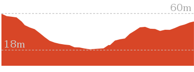
Cross sectional view of the Kanning Cave Walk bushwalking track
Analysis and summary of the altitude variation on the Kanning Cave Walk
Overview of this walks grade – based on the AS 2156.1 – 2001
Under this standard, a walk is graded based on the most difficult section of the walk.
| Length | 922 m | ||
| Time | 20 mins | ||
| . | |||
| Grade 2/6 Easy track |
AS 2156.1 | Gradient | Gentle hills with occasional steps (2/6) |
| Quality of track | Clear and well formed track or trail (2/6) | ||
| Signs | Clearly signposted (1/6) | ||
| Experience Required | No experience required (1/6) | ||
| Weather | Weather generally has little impact on safety (1/6) | ||
| Infrastructure | Generally useful facilities (such as fenced cliffs and seats) (1/6) |
Some more details of this walks Grading
Here is a bit more details explaining grading looking at sections of the walk
Gradient
Around 370m of this walk has gentle hills with occasional steps, whilst the remaining 95m is flat with no steps.
Quality of track
Around 370m of this walk follows a clear and well formed track or trail, whilst the remaining 95m follows a smooth and hardened path.
Signs
This whole walk, 460m is clearly signposted.
Experience Required
This whole walk, 460m requires no previous bushwalking experience.
weather
This whole walk, 460m is not usually affected by severe weather events (that would unexpectedly impact safety and navigation).
Infrastructure
This whole walk, 460m is close to useful facilities (such as fenced cliffs and seats).
Similar walks
A list of walks that share part of the track with the Kanning Cave Walk walk.
1.3 km Circuit
30 mins
Easy track
3.2 km Return
1 hr 15 mins
Easy track
4.5 km One way
2 hrs
Hard track
Other Nearby walks
A list of walks that start near the Kanning Cave Walk walk.
962 m Circuit
30 mins
Moderate track
4.1 km One way
1 hr 45 mins
Hard track
1.5 km Return
30 mins
Easy track
1.7 km One way
1 Hr
Moderate track
1.5 km One way
45 mins
Hard track
2.9 km Circuit
1 hr 30 mins
Hard track
2.2 km Return
1 hr 15 mins
Hard track
5.3 km Circuit
2 hrs 45 mins
Moderate track
8.5 km One way
3 hrs 45 mins
Hard track
2 km Return
1 Hr
Moderate track
890 m Return
30 mins
Easy track
1.6 km Circuit
45 mins
Easy track
Plan your trip to and from the walk here
The Kanning Cave Walk walk starts and ends at the Mudbrick building car park (gps: -33.459135, 151.39183)
Your main transport option to Mudbrick building car park is by;
![]() Car. There is free parking available.
Car. There is free parking available.
(get details)
Short URL = http://wild.tl/kcw
Gallery images
There are other downloads I am still working on.
You will probably need to login to access these — still all free.
* KML (google earth file)
* GPX (GPS file)
Special Maps/ brochures
* A3 topo maps
* PDF with Lands Topo map base
* PDF with arial image (and map overlay)
I wanted to get the main site live first, this extra stuff will come in time.
Happy walking
Matt 🙂
Ridge Trail loop
And Walk
Ridge Trail loop

30 mins
962 m Circuit
48 m
Moderate track
The Ridge Trail loop is a short walk starting from Honeman’s Picnic Area and follows the signposted Ridge Trail until finding Split Rock management trail. Here, you turn sharply right to head back to the picnic area along this wider trail. There are limited views along this walk, but it still makes for a nice stroll through the bush.


Honeman’s Rock picnic area
Honeman’s Rock picnic area is a large picnic area at the top end of Island View Drive. This picnic area has a couple of large grassy areas[1], composting toilets[2], free electric BBQs[3], picnic tables[4], shelters, garbage bins[5], drinking water[6] and information signs[7]. The picnic area is home to a mud brick building[8] (available for hire) and Honeman’s Rock[9], from which the area derives its name. There is a fair amount of parking available next the picnic area, and some extra spaces a few hundred meters down the road.
Mud Brick Building
The mud brick building is a landmark in the main picnic area at Kincumber Mountain, and is a popular spot to gather. Also known as ‘Kincumber Mountain Information Centre’, ‘The Kiosk’, ‘Kincumber Kiosk’ and ‘Kincumber Mountain Kiosk’, the building was constructed in 1986 with funding from Community Employment Programme. The building is generally locked but can be booked through the local Lions Club for special events. The building has a rain water tank, small kitchen and one main large room. The verandah also provides good shelter.
(0km) Mudbrick building car park → Start of Ridge trail
60 m
1 mins
2m
-3m
Very easy
From the car park next to the mud brick building, this walk heads downhill beside the road against the flow of traffic. The road bends left and comes to a ‘T’ intersection, where this walk turns left and heads up the road (past the ‘No Entry’ road sign[12]) for about 20m, coming to the intersection with the signposted ‘Ridge Trail’[13] (on the right).
(0.06km) Start of Ridge trail → Int of Ridge trail and split rock management trail
410 m
8 mins
1m
-41m
Moderate track
Veer right: From the intersection, this walk follows the ‘Ridge Trail 1500m’ sign[14] away from the road and picnic area. The track soon leads over a rock platform and down the steps. The track then follows the ridge, passing close to a management trail (on the right) a couple of times and down a series of timber steps. The track leads down through some rocks and, just after this, comes to an intersection at the end of the management trail in a sandy clearing.
(0.46km) Int of Ridge trail and split rock management trail → Honeman’s Rock
440 m
10 mins
37m
-4m
Moderate track
Turn right: From the intersection, this walk follows the management trail north, gently downhill (keeping the Ridge Track on the right). The walk enjoys some filtered views to the left before starting to climb gently up the hill and passing very close to the Ridge Track a couple of times (on the right). The trail soon comes to and passes some large split rock boulders then rounds a locked gate. From here, the walk heads up the hill then crosses the road and rounds another locked gate, coming to the southern end of Honeman’s Rock (with the mud brick building up the hill to the right).
Honeman’s Rock
Honeman’s Rock (aka Honeyman’s Rock) is a large rock outcrop in front of the mud brick building, in the Honeman’s Rock Picnic area. The exposed section of rock is 60m long and about 30m wide, with the western side having a significant unfenced drop. The rock is named after Cecil Lyle Honeman who became a lease holder on the mountain in 1962. The rock has a large depression that once filled with water, and a drain has been dug to keep the pool empty and clear of rubbish.
(0.9km) Honeman’s Rock → Mudbrick building car park
60 m
2 mins
8m
0m
Easy track
Turn right: From Honeman’s rock, this walk heads up the hill over the grassy clearing to the front of the mud brick building and the car park on the right.
Maps for the Ridge Trail loop walk
You can download the PDF for this walk to print a map.
These maps below cover the walk and the wider area around the walk, they are worth carrying for safety reasons.
| Gosford | 1:25 000 Map Series | 91312S GOSFORD | NSW-91312S |
| Gosford | 1:100 000 Map Series | 9131 GOSFORD | 9131 |
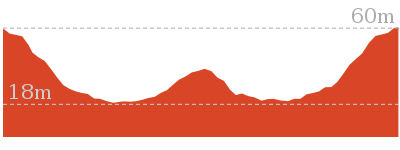
Cross sectional view of the Ridge Trail loop bushwalking track
Analysis and summary of the altitude variation on the Ridge Trail loop
Overview of this walks grade – based on the AS 2156.1 – 2001
Under this standard, a walk is graded based on the most difficult section of the walk.
| Length | 962 m | ||
| Time | 30 mins | ||
| . | |||
| Grade 3/6 Moderate track |
AS 2156.1 | Gradient | Short steep hills (3/6) |
| Quality of track | Formed track, with some branches and other obstacles (3/6) | ||
| Signs | Directional signs along the way (3/6) | ||
| Experience Required | No experience required (1/6) | ||
| Weather | Weather generally has little impact on safety (1/6) | ||
| Infrastructure | Generally useful facilities (such as fenced cliffs and seats) (1/6) |
Some more details of this walks Grading
Here is a bit more details explaining grading looking at sections of the walk
Gradient
500m of this walk has gentle hills with occasional steps and another 410m has short steep hills. The remaining (55m) is flat with no steps.
Quality of track
500m of this walk follows a clear and well formed track or trail and another 410m follows a formed track, with some branches and other obstacles. The remaining (55m) follows a smooth and hardened path.
Signs
Around 850m of this walk has directional signs at most intersection, whilst the remaining 120m is clearly signposted.
Experience Required
This whole walk, 960m requires no previous bushwalking experience.
weather
This whole walk, 960m is not usually affected by severe weather events (that would unexpectedly impact safety and navigation).
Infrastructure
This whole walk, 960m is close to useful facilities (such as fenced cliffs and seats).
Similar walks
A list of walks that share part of the track with the Ridge Trail loop walk.
1.7 km One way
1 Hr
Moderate track
4.5 km One way
2 hrs
Hard track
Other Nearby walks
A list of walks that start near the Ridge Trail loop walk.
922 m Return
20 mins
Easy track
1.3 km Circuit
30 mins
Easy track
3.2 km Return
1 hr 15 mins
Easy track
4.1 km One way
1 hr 45 mins
Hard track
1.5 km Return
30 mins
Easy track
1.5 km One way
45 mins
Hard track
2.9 km Circuit
1 hr 30 mins
Hard track
2.2 km Return
1 hr 15 mins
Hard track
5.3 km Circuit
2 hrs 45 mins
Moderate track
8.5 km One way
3 hrs 45 mins
Hard track
2 km Return
1 Hr
Moderate track
890 m Return
30 mins
Easy track
Plan your trip to and from the walk here
The Ridge Trail loop walk starts and ends at the Mudbrick building car park (gps: -33.459136, 151.39182)
Your main transport option to Mudbrick building car park is by;
![]() Car. There is free parking available.
Car. There is free parking available.
(get details)
Short URL = http://wild.tl/rtl
Gallery images
There are other downloads I am still working on.
You will probably need to login to access these — still all free.
* KML (google earth file)
* GPX (GPS file)
Special Maps/ brochures
* A3 topo maps
* PDF with Lands Topo map base
* PDF with arial image (and map overlay)
I wanted to get the main site live first, this extra stuff will come in time.
Happy walking
Matt 🙂
Kanning Walk
And Walk
Kanning Walk

30 mins
1.3 km Circuit
38 m
Easy track
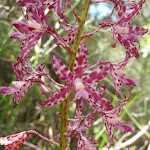
This lovely walk is a great way to explore the bushland at the top of Kincumber Mountain. From near the main picnic area, you follow a clear track before walking along the base of a long rock wall. There are a few sandstone caves, the main one mentioned in the notes is quite large, and a nice cool spot on a hot day. This walk then heads past the cave to loop back to the start via the Yanina Walk management trail. There are good wildflower displays in spring and summer.


Honeman’s Rock picnic area
Honeman’s Rock picnic area is a large picnic area at the top end of Island View Drive. This picnic area has a couple of large grassy areas[1], composting toilets[2], free electric BBQs[3], picnic tables[4], shelters, garbage bins[5], drinking water[6] and information signs[7]. The picnic area is home to a mud brick building[8] (available for hire) and Honeman’s Rock[9], from which the area derives its name. There is a fair amount of parking available next the picnic area, and some extra spaces a few hundred meters down the road.
Mud Brick Building
The mud brick building is a landmark in the main picnic area at Kincumber Mountain, and is a popular spot to gather. Also known as ‘Kincumber Mountain Information Centre’, ‘The Kiosk’, ‘Kincumber Kiosk’ and ‘Kincumber Mountain Kiosk’, the building was constructed in 1986 with funding from Community Employment Programme. The building is generally locked but can be booked through the local Lions Club for special events. The building has a rain water tank, small kitchen and one main large room. The verandah also provides good shelter.
(0km) Mudbrick building car park → Kanning Walk gate
90 m
1 mins
5m
0m
Very easy
From the car park, this walk heads up the road, initially keeping the mud brick building to the left. Soon the road leads to an intersection (next to an information board and fence on the left).
Turn right: From the intersection, this walk follows the ‘One Way’ road sign[12] away from the picnic area and along the road. Almost immediately, there is a locked gate and the ‘Kanning Walk’ sign[13] (on the left).
Turn right: From the intersection, this walk follows the ‘One Way’ road sign[12] away from the picnic area and along the road. Almost immediately, there is a locked gate and the ‘Kanning Walk’ sign[13] (on the left).
(0.09km) Kanning Walk gate → Cave
370 m
7 mins
11m
-18m
Easy track
Turn left: From the road, this walk follows the ‘Kanning Walk cave 300 metres’ sign[14] around the locked gate and along the old sandy management trail. After about 120m the walk turns right, following another ‘Kanning Walk’ sign[15], and passes between two large, exposed tree root systems. Soon after this, the track is concrete for a short distance and passes along the base of a long rock wall. The walk goes down some steel stairs and across a timber bridge, coming to a sandstone overhang cave. This cave is quite large and has a ‘cave 100m’ sign[16], pointing further along the track. Follow this sign for about 150m, passing over a steel platform, up a small rise and down some steel stairs. From the base of these stairs, the walk continues for about 25m along the flat track to find the unsignposted entrance to the cave. The entrance is between two large boulders on the left[17].
Kanning Walk Cave
The main cave on Kanning Walk is surprising large for a sandstone environment. The cave has two main sections. There is a large cabin about 7m wide and 9m deep. A small tunnel extends about 10m further to a small chamber at the back. The entrance to the cave is behind two large boulders, providing extra shelter. It is believed that A. A. Glasson lived in the cave in the early 1930’s, which was not uncommon during the depression. The cave has proved to be a great place to rest on hot days.
(0.46km) Cave → Int of Kanning and Yanina walks
220 m
5 mins
13m
-7m
Easy track
Continue straight: From the entrance to the cave, this walk follows the track around the base of the rock wall, keeping the rock to the left. Soon the track passes (and follows) an ‘Alternate Return’ sign[19] then leads up some timber steps. The track soon flattens out and heads through a timber barrier, coming to a ‘T’ intersection with a wide management trail, and a few ‘Kanning Walk’ signs[20].
(0.68km) Int of Kanning and Yanina walks → End of Island View Dr
400 m
7 mins
9m
-6m
Easy track
Turn left: From the intersection, this walk follows the ‘Kanning Walk’ & ‘Mudbrick Building’ signs[21] along the management trail. After about 40m, the trail passes a track and locked gate (on the left, which leads to the roof of a cave) and continues along the wide trail for another 230m. Just as the walk comes into view of a cottage (straight ahead through the trees), the trail comes to a clear intersection with a link track (on the right).
Continue straight: From the intersection, this walk follows the wide trail gently downhill towards the house (just visible through the trees). The trail passes a fence (on the left) as the trail bends left and after about 70m, passes a cottage (the house on the right). About 50m further along the trail, the walk passes a ‘Yanina Walk Colin Watters Lookout’ sign[22], and heads around a locked gate to Island View Rd.
Continue straight: From the intersection, this walk follows the wide trail gently downhill towards the house (just visible through the trees). The trail passes a fence (on the left) as the trail bends left and after about 70m, passes a cottage (the house on the right). About 50m further along the trail, the walk passes a ‘Yanina Walk Colin Watters Lookout’ sign[22], and heads around a locked gate to Island View Rd.
(1.09km) End of Island View Dr → Mudbrick building car park
180 m
3 mins
0m
-7m
Very easy
Continue straight: From the end of the road, this walk follows the road away from the locked gate and ‘Yanina Walk’ sign[23], keeping the picnic area to the right. The road bends a little, passing a few more car parks and an information board before coming to an intersection marked with a ‘No Entry’ sign[24].
Continue straight: From the intersection, this walk heads downhill along the road, passing the ‘No Entry’ sign[25] and keeping the picnic area on the right. The road soon comes to another car park next to the mud brick building.
Continue straight: From the intersection, this walk heads downhill along the road, passing the ‘No Entry’ sign[25] and keeping the picnic area on the right. The road soon comes to another car park next to the mud brick building.
Maps for the Kanning Walk walk
You can download the PDF for this walk to print a map.
These maps below cover the walk and the wider area around the walk, they are worth carrying for safety reasons.
| Gosford | 1:25 000 Map Series | 91312S GOSFORD | NSW-91312S |
| Gosford | 1:100 000 Map Series | 9131 GOSFORD | 9131 |
Cross sectional view of the Kanning Walk bushwalking track
Analysis and summary of the altitude variation on the Kanning Walk
Overview of this walks grade – based on the AS 2156.1 – 2001
Under this standard, a walk is graded based on the most difficult section of the walk.
| Length | 1.3 km | ||
| Time | 30 mins | ||
| . | |||
| Grade 2/6 Easy track |
AS 2156.1 | Gradient | Gentle hills with occasional steps (2/6) |
| Quality of track | Clear and well formed track or trail (2/6) | ||
| Signs | Clearly signposted (1/6) | ||
| Experience Required | No experience required (1/6) | ||
| Weather | Weather generally has little impact on safety (1/6) | ||
| Infrastructure | Generally useful facilities (such as fenced cliffs and seats) (1/6) |
Some more details of this walks Grading
Here is a bit more details explaining grading looking at sections of the walk
Gradient
Around 990m of this walk has gentle hills with occasional steps, whilst the remaining 270m is flat with no steps.
Quality of track
Around 990m of this walk follows a clear and well formed track or trail, whilst the remaining 270m follows a smooth and hardened path.
Signs
This whole walk, 1.3km is clearly signposted.
Experience Required
This whole walk, 1.3km requires no previous bushwalking experience.
weather
This whole walk, 1.3km is not usually affected by severe weather events (that would unexpectedly impact safety and navigation).
Infrastructure
This whole walk, 1.3km is close to useful facilities (such as fenced cliffs and seats).
Similar walks
A list of walks that share part of the track with the Kanning Walk walk.
922 m Return
20 mins
Easy track
3.2 km Return
1 hr 15 mins
Easy track
4.5 km One way
2 hrs
Hard track
Other Nearby walks
A list of walks that start near the Kanning Walk walk.
962 m Circuit
30 mins
Moderate track
4.1 km One way
1 hr 45 mins
Hard track
1.5 km Return
30 mins
Easy track
1.7 km One way
1 Hr
Moderate track
1.5 km One way
45 mins
Hard track
2.9 km Circuit
1 hr 30 mins
Hard track
2.2 km Return
1 hr 15 mins
Hard track
5.3 km Circuit
2 hrs 45 mins
Moderate track
8.5 km One way
3 hrs 45 mins
Hard track
2 km Return
1 Hr
Moderate track
890 m Return
30 mins
Easy track
1.6 km Circuit
45 mins
Easy track
Plan your trip to and from the walk here
The Kanning Walk walk starts and ends at the Mudbrick building car park (gps: -33.459135, 151.39183)
Your main transport option to Mudbrick building car park is by;
![]() Car. There is free parking available.
Car. There is free parking available.
(get details)
Short URL = http://wild.tl/kw
Gallery images
There are other downloads I am still working on.
You will probably need to login to access these — still all free.
* KML (google earth file)
* GPX (GPS file)
Special Maps/ brochures
* A3 topo maps
* PDF with Lands Topo map base
* PDF with arial image (and map overlay)
I wanted to get the main site live first, this extra stuff will come in time.
Happy walking
Matt 🙂
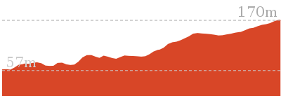
Warri Warri Track (via Warriwarri Lookout)

45 mins
1.5 km One way
147 m
Hard track
Starting on Bembooka Rd in Erina, this walk heads up the narrow Warri Warri track to Honeman’s picnic area. You will visit the overgrown Warriwarri Lookout about halfway along this walk, but do not expect grand views! From the lookout, the walk follows wider trails along the much flatter ridge top to the popular Honeman’s Lookout.


(0km) Start of Bembooka Rd → Warriwarri Lookout
720 m
17 mins
123m
-3m
Hard track
From opposite number 2 Bembooka Rd, Green Point (just downhill from the roundabout), this walk leaves the road and follows the track into the bush, with a fence on the right. The track soon leaves the fence (and ignores a track to the right) and heads up the hill. The track follows the ridge, getting steeper as it gets higher. As the track nears the rocks, it zigzags a little, working its way up, then a short distance later comes to a clearing, bench seat and the signposted ‘Warriwarri Lookout’ sign[1].
Warriwarri Lookout
Warriwarri Lookout is an overgrown and signposted[2] lookout in the middle of Kincumber Mountain Reserve. There is a fairly large clearing and a bench seat[3]. There are slightly better views north, past the sign at the unfenced rock outcrop. The filtered views look north-east. The view from the lookout is overgrown, so do not expect much in the way of views.
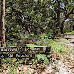
(0.72km) Warriwarri Lookout → Int of Sid Pulsford Walking and Warriwarri Lookout trails
290 m
5 mins
19m
-1m
Easy track
Veer right: From the lookout, this walk heads away from the ‘Warriwarri Lookout’ sign[4] up the small rise, past the bench seat and along the wide sandy trail. Following the now flat, sandy trail though the bush, the walk passes an informal track (on the left) and comes to a three-way intersection and a ‘Warriwarri Lookout’ sign[5] pointing back along the trail.
(1.01km) Int of Sid Pulsford Walking and Warriwarri Lookout trails → Northern end of picnic area
290 m
5 mins
4m
-5m
Easy track
Continue straight: From the intersection, this walk heads south, away from the face of the two signs[6] (following neither arrow). The walk passes a large angophora and comes to an intersection with a link track (on the left).
Continue straight: From the intersection, this walk follows the wide trail south, gently uphill, keeping the wide valley on the right. The walk follows the sandy trail as it gently winds through the wooded forest and soon heads around a locked gate, coming to a large ‘Sid Pulsford Walking Trail’ sign[7] at the northern end of the large grassy picnic area.
Continue straight: From the intersection, this walk follows the wide trail south, gently uphill, keeping the wide valley on the right. The walk follows the sandy trail as it gently winds through the wooded forest and soon heads around a locked gate, coming to a large ‘Sid Pulsford Walking Trail’ sign[7] at the northern end of the large grassy picnic area.
(1.3km) Northern end of picnic area → Mudbrick building car park
180 m
3 mins
1m
-4m
Easy track
Continue straight: From here, this walk heads directly across the picnic area to the buildings on the far side. After passing the toilet block, the walk follows the path around the mud brick building to a small car park on the other side.
Honeman’s Rock picnic area
Honeman’s Rock picnic area is a large picnic area at the top end of Island View Drive. This picnic area has a couple of large grassy areas[8], composting toilets[9], free electric BBQs[10], picnic tables[11], shelters, garbage bins[12], drinking water[13] and information signs[14]. The picnic area is home to a mud brick building[15] (available for hire) and Honeman’s Rock[16], from which the area derives its name. There is a fair amount of parking available next the picnic area, and some extra spaces a few hundred meters down the road.
Mud Brick Building
The mud brick building is a landmark in the main picnic area at Kincumber Mountain, and is a popular spot to gather. Also known as ‘Kincumber Mountain Information Centre’, ‘The Kiosk’, ‘Kincumber Kiosk’ and ‘Kincumber Mountain Kiosk’, the building was constructed in 1986 with funding from Community Employment Programme. The building is generally locked but can be booked through the local Lions Club for special events. The building has a rain water tank, small kitchen and one main large room. The verandah also provides good shelter.
Honeman’s Rock
Honeman’s Rock (aka Honeyman’s Rock) is a large rock outcrop in front of the mud brick building, in the Honeman’s Rock Picnic area. The exposed section of rock is 60m long and about 30m wide, with the western side having a significant unfenced drop. The rock is named after Cecil Lyle Honeman who became a lease holder on the mountain in 1962. The rock has a large depression that once filled with water, and a drain has been dug to keep the pool empty and clear of rubbish.
Maps for the Warri Warri Track (via Warriwarri Lookout) walk
You can download the PDF for this walk to print a map.
These maps below cover the walk and the wider area around the walk, they are worth carrying for safety reasons.
| Gosford | 1:25 000 Map Series | 91312S GOSFORD | NSW-91312S |
| Gosford | 1:100 000 Map Series | 9131 GOSFORD | 9131 |
Cross sectional view of the Warri Warri Track (via Warriwarri Lookout) bushwalking track
Analysis and summary of the altitude variation on the Warri Warri Track (via Warriwarri Lookout)
Overview of this walks grade – based on the AS 2156.1 – 2001
Under this standard, a walk is graded based on the most difficult section of the walk.
| Length | 1.5 km | ||
| Time | 45 mins | ||
| . | |||
| Grade 4/6 Hard track |
AS 2156.1 | Gradient | Short steep hills (3/6) |
| Quality of track | Clear and well formed track or trail (2/6) | ||
| Signs | Minimal directional signs (4/6) | ||
| Experience Required | Some bushwalking experience recommended (3/6) | ||
| Weather | Weather generally has little impact on safety (1/6) | ||
| Infrastructure | Generally useful facilities (such as fenced cliffs and seats) (1/6) |
Some more details of this walks Grading
Here is a bit more details explaining grading looking at sections of the walk
Gradient
720m of this walk has short steep hills and another 580m has gentle hills with occasional steps. The remaining (180m) is flat with no steps.
Quality of track
This whole walk, 1.5km follows a clear and well formed track or trail.
Signs
Around 770m of this walk is clearly signposted, whilst the remaining 720m has minimal directional signs.
Experience Required
Around 770m of this walk requires no previous bushwalking experience, whilst the remaining 720m requires some bushwalking experience.
weather
This whole walk, 1.5km is not usually affected by severe weather events (that would unexpectedly impact safety and navigation).
Infrastructure
This whole walk, 1.5km is close to useful facilities (such as fenced cliffs and seats).
Similar walks
A list of walks that share part of the track with the Warri Warri Track (via Warriwarri Lookout) walk.
1.5 km Return
30 mins
Easy track
4.1 km One way
1 hr 45 mins
Hard track
Other Nearby walks
A list of walks that start near the Warri Warri Track (via Warriwarri Lookout) walk.
962 m Circuit
30 mins
Moderate track
922 m Return
20 mins
Easy track
1.3 km Circuit
30 mins
Easy track
3.2 km Return
1 hr 15 mins
Easy track
2.9 km Circuit
1 hr 30 mins
Hard track
2.2 km Return
1 hr 15 mins
Hard track
1.7 km One way
1 Hr
Moderate track
4.5 km One way
2 hrs
Hard track
3 km Return
1 hr 30 mins
Hard track
2.2 km One way
1 Hr
Hard track
991 m One way
30 mins
Moderate track
1.7 km Circuit
45 mins
Moderate track
Plan your trip to and from the walk here
The Warri Warri Track (via Warriwarri Lookout) walk starts at the Start of Bembooka Rd (gps: -33.449206, 151.38512)
Your transport options to Start of Bembooka Rd are by;
![]() Bus. (get details)
Bus. (get details)
![]() Car. There is free parking available.
Car. There is free parking available.
(get details)
The Warri Warri Track (via Warriwarri Lookout) ends at the Mudbrick building car park (gps: -33.459138, 151.39182)
Your main transport option to Mudbrick building car park is by;
![]() Car. There is free parking available.
Car. There is free parking available.
(get details)
Short URL = http://wild.tl/wwtwl
Gallery images
There are other downloads I am still working on.
You will probably need to login to access these — still all free.
* KML (google earth file)
* GPX (GPS file)
Special Maps/ brochures
* A3 topo maps
* PDF with Lands Topo map base
* PDF with arial image (and map overlay)
I wanted to get the main site live first, this extra stuff will come in time.
Happy walking
Matt 🙂
Warriwarri Lookout
And Walk
Warriwarri Lookout

30 mins
1.5 km Return
34 m
Easy track
This short and fairly flat walk starts from the popular Honeman’s picnic area and follows the Sid Pulsford Walking Track, then another trail to Warriwarri Lookout. The lookout is overgrown and provides no real view. A short distance beyond the signposted lookout is a rocky outcrop that provides some filtered views of the district. A nice walk through the dry ridge top forest, just don’t expect grand views.


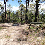
Honeman’s Rock picnic area
Honeman’s Rock picnic area is a large picnic area at the top end of Island View Drive. This picnic area has a couple of large grassy areas[1], composting toilets[2], free electric BBQs[3], picnic tables[4], shelters, garbage bins[5], drinking water[6] and information signs[7]. The picnic area is home to a mud brick building[8] (available for hire) and Honeman’s Rock[9], from which the area derives its name. There is a fair amount of parking available next the picnic area, and some extra spaces a few hundred meters down the road.
Honeman’s Rock
Honeman’s Rock (aka Honeyman’s Rock) is a large rock outcrop in front of the mud brick building, in the Honeman’s Rock Picnic area. The exposed section of rock is 60m long and about 30m wide, with the western side having a significant unfenced drop. The rock is named after Cecil Lyle Honeman who became a lease holder on the mountain in 1962. The rock has a large depression that once filled with water, and a drain has been dug to keep the pool empty and clear of rubbish.
Mud Brick Building
The mud brick building is a landmark in the main picnic area at Kincumber Mountain, and is a popular spot to gather. Also known as ‘Kincumber Mountain Information Centre’, ‘The Kiosk’, ‘Kincumber Kiosk’ and ‘Kincumber Mountain Kiosk’, the building was constructed in 1986 with funding from Community Employment Programme. The building is generally locked but can be booked through the local Lions Club for special events. The building has a rain water tank, small kitchen and one main large room. The verandah also provides good shelter.
(0km) Mudbrick building car park → Northern end of picnic area
180 m
3 mins
4m
-1m
Easy track
From the car park next to the mud brick building, this walk heads in front of the mud brick building and follows the path to the toilet block. Here, the walk heads across the grass between the picnic table (under the tree on the left) and the BBQ shelter (on the right) to the far end of the clearing, near another picnic table, to find the ‘Sid Pulsford Walking Trail’ sign[13].
(0.18km) Northern end of picnic area → Int of Sid Pulsford Walking and Warriwarri Lookout trails
290 m
5 mins
5m
-4m
Easy track
Continue straight: From the picnic area, this walk follows the ‘Sid Pulsford Walking Trail’ sign[14] around the locked gate and away from the clearing. The walk gently winds through the bush along the wide sandy trail, and comes to an intersection with a link track (heading up to the right) just after a large angophora.
Continue straight: From the intersection, this walk follows the wide management trail north, past the large twisted angophora, coming to the ‘Y’ intersection marked by two signs[15] (just visible from the previous intersection).
Continue straight: From the intersection, this walk follows the wide management trail north, past the large twisted angophora, coming to the ‘Y’ intersection marked by two signs[15] (just visible from the previous intersection).
(0.48km) Int of Sid Pulsford Walking and Warriwarri Lookout trails → Warriwarri Lookout
290 m
5 mins
1m
-19m
Easy track
Continue straight: From the intersection, this walk follows the ‘Warriwarri Lookout’ sign[16] north along the wide sandy trail. The flat trail gently winds through the bush, passing an informal track (on the right) and soon coming to a small clearing, bench seat and signposted ‘Warriwarri Lookout’[17], which offers limited views.
Warriwarri Lookout
Warriwarri Lookout is an overgrown and signposted[18] lookout in the middle of Kincumber Mountain Reserve. There is a fairly large clearing and a bench seat[19]. There are slightly better views north, past the sign at the unfenced rock outcrop. The filtered views look north-east. The view from the lookout is overgrown, so do not expect much in the way of views.
Maps for the Warriwarri Lookout walk
You can download the PDF for this walk to print a map.
These maps below cover the walk and the wider area around the walk, they are worth carrying for safety reasons.
| Gosford | 1:25 000 Map Series | 91312S GOSFORD | NSW-91312S |
| Gosford | 1:100 000 Map Series | 9131 GOSFORD | 9131 |
Cross sectional view of the Warriwarri Lookout bushwalking track
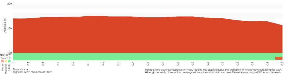
Analysis and summary of the altitude variation on the Warriwarri Lookout
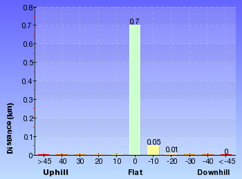
Overview of this walks grade – based on the AS 2156.1 – 2001
Under this standard, a walk is graded based on the most difficult section of the walk.
| Length | 1.5 km | ||
| Time | 30 mins | ||
| . | |||
| Grade 2/6 Easy track |
AS 2156.1 | Gradient | Gentle hills with occasional steps (2/6) |
| Quality of track | Clear and well formed track or trail (2/6) | ||
| Signs | Clearly signposted (1/6) | ||
| Experience Required | No experience required (1/6) | ||
| Weather | Weather generally has little impact on safety (1/6) | ||
| Infrastructure | Generally useful facilities (such as fenced cliffs and seats) (1/6) |
Some more details of this walks Grading
Here is a bit more details explaining grading looking at sections of the walk
Gradient
Around 580m of this walk has gentle hills with occasional steps, whilst the remaining 180m is flat with no steps.
Quality of track
This whole walk, 770m follows a clear and well formed track or trail.
Signs
This whole walk, 770m is clearly signposted.
Experience Required
This whole walk, 770m requires no previous bushwalking experience.
weather
This whole walk, 770m is not usually affected by severe weather events (that would unexpectedly impact safety and navigation).
Infrastructure
This whole walk, 770m is close to useful facilities (such as fenced cliffs and seats).
Similar walks
A list of walks that share part of the track with the Warriwarri Lookout walk.
1.5 km One way
45 mins
Hard track
4.1 km One way
1 hr 45 mins
Hard track
Other Nearby walks
A list of walks that start near the Warriwarri Lookout walk.
962 m Circuit
30 mins
Moderate track
922 m Return
20 mins
Easy track
1.3 km Circuit
30 mins
Easy track
3.2 km Return
1 hr 15 mins
Easy track
1.7 km One way
1 Hr
Moderate track
4.5 km One way
2 hrs
Hard track
2.9 km Circuit
1 hr 30 mins
Hard track
2.2 km Return
1 hr 15 mins
Hard track
5.3 km Circuit
2 hrs 45 mins
Moderate track
8.5 km One way
3 hrs 45 mins
Hard track
2 km Return
1 Hr
Moderate track
890 m Return
30 mins
Easy track
Plan your trip to and from the walk here
The Warriwarri Lookout walk starts and ends at the Mudbrick building car park (gps: -33.459138, 151.39182)
Your main transport option to Mudbrick building car park is by;
![]() Car. There is free parking available.
Car. There is free parking available.
(get details)
Short URL = http://wild.tl/2e
Gallery images
There are other downloads I am still working on.
You will probably need to login to access these — still all free.
* KML (google earth file)
* GPX (GPS file)
Special Maps/ brochures
* A3 topo maps
* PDF with Lands Topo map base
* PDF with arial image (and map overlay)
I wanted to get the main site live first, this extra stuff will come in time.
Happy walking
Matt 🙂
Glasson’s Trail
And Walk
Glasson’s Trail

1 Hr
1.7 km One way
158 m
Moderate track
Glasson’s Trail starts near the main entrance to Kincumber Mountain Reserve and follows a series of management trails and tracks up to the main picnic area. The walk offers a great way to explore the diverse vegetation and visiting some interesting rock formations. The walk is signposted and crosses the road a few times before coming across a single picnic table near the end of the walk. The walk finishes at the more popular picnic area at Honeman’s Rock.
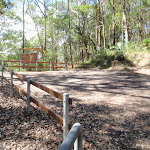


(0km) Glasson’s Car Park → Water tank intersection
160 m
4 mins
18m
-3m
Moderate track
From the car park (about 230m from the end of Kincumber St past the ‘Kincumber Mountain Regional Reserve’ sign[1]), this walk heads to the back of the car park, through the gap in the fence and turns right. The walk follows the track, keeping the water tank up the hill to the right. The walk leads up some timber steps through the rocks and, soon after passing the water tank, the track comes to a ‘T’ intersection with a management trail.
(0.16km) Water tank intersection → Glasson’s crossing
810 m
21 mins
66m
-35m
Easy track
Veer left: From the intersection, this walk follows the wide management trail away from the water tank and gently down the hill, keeping the valley to the left. The trail meanders through the bush for about 300m, rounding a wide sweeping right-hand bend – during this bend, the walk comes to a rocky outcrop with a view into the valley (on the left). From here, the walk continues around the bend and up the hill. As the walk enters a more lush section of forest, the trail becomes narrower for a while. The trail then begins to climb again as it widens back out, before coming to a locked gate and road. The walk crosses the road, coming to a small clearing on the other side.
(0.97km) Glasson’s crossing → Bottom of Overflow car park
490 m
12 mins
46m
-6m
Moderate track
Continue straight: From the clearing, this walk heads up the ramp behind the clearing, keeping the road to the left. The track leads up the timber steps, between the timber posts and turns right, heading up more steps. The rocky track flattens out somewhat and heads along the top of the ridge, among the grass trees and angophora forest, where the track then leads down the hill to the road. At the road, the walk turns right to follow the road for about 10m, then turns left and follows the track back into the bush (now with the road to the right). This track gently meanders for almost 100m before coming to the bottom of a car park, a picnic shelter and a ‘Glasson’s Trail – Island View Entrance 1300 metres’ sign[2] pointing back down the track.
Glasson’s Trail Picnic Area
At the lower end of the overflow car park, near the top of Glasson’s Trail, is a single picnic table and shelter[3]. There are no other facilities here. A short distance from the main picnic area, this is an alternative spot for those wanting a picnic table amongst more native trees.
(1.46km) Bottom of Overflow car park → Top of Overflow car park
50 m
2 mins
8m
0m
Very easy
Continue straight: From the picnic shelter, this walk heads uphill across the car park to another ‘Glasson’s Trail’[4] sign, at the base of the stone steps.
(1.51km) Top of Overflow car park → Honeman’s Rock
130 m
3 mins
12m
0m
Easy track
Veer left: From the top of the car park, this walk follows the ‘Glassons Trail – Honemans Rock picnic area’ sign[5] up the stone steps. The track follows the footpath for a short time before coming to a large clearing and another ‘Glassons Trail’ sign[6] pointing back down to the car park. From here, the walk heads across the grassy area, bending to the right around the rock to come to the end of Honeman’s rock (on the left) and a gate (on the right) (just in view of the mud brick building).
Honeman’s Rock
Honeman’s Rock (aka Honeyman’s Rock) is a large rock outcrop in front of the mud brick building, in the Honeman’s Rock Picnic area. The exposed section of rock is 60m long and about 30m wide, with the western side having a significant unfenced drop. The rock is named after Cecil Lyle Honeman who became a lease holder on the mountain in 1962. The rock has a large depression that once filled with water, and a drain has been dug to keep the pool empty and clear of rubbish.
(1.63km) Honeman’s Rock → Mudbrick building car park
60 m
2 mins
8m
0m
Easy track
Continue straight: From Honeman’s rock, this walk heads up the hill over the grassy clearing to the front of the mud brick building and the car park on the right.
Mud Brick Building
The mud brick building is a landmark in the main picnic area at Kincumber Mountain, and is a popular spot to gather. Also known as ‘Kincumber Mountain Information Centre’, ‘The Kiosk’, ‘Kincumber Kiosk’ and ‘Kincumber Mountain Kiosk’, the building was constructed in 1986 with funding from Community Employment Programme. The building is generally locked but can be booked through the local Lions Club for special events. The building has a rain water tank, small kitchen and one main large room. The verandah also provides good shelter.
Honeman’s Rock picnic area
Honeman’s Rock picnic area is a large picnic area at the top end of Island View Drive. This picnic area has a couple of large grassy areas[10], composting toilets[11], free electric BBQs[12], picnic tables[13], shelters, garbage bins[14], drinking water[15] and information signs[16]. The picnic area is home to a mud brick building[17] (available for hire) and Honeman’s Rock[18], from which the area derives its name. There is a fair amount of parking available next the picnic area, and some extra spaces a few hundred meters down the road.
Maps for the Glasson’s Trail walk
You can download the PDF for this walk to print a map.
These maps below cover the walk and the wider area around the walk, they are worth carrying for safety reasons.
| Gosford | 1:25 000 Map Series | 91312S GOSFORD | NSW-91312S |
| Gosford | 1:100 000 Map Series | 9131 GOSFORD | 9131 |
Cross sectional view of the Glasson’s Trail bushwalking track
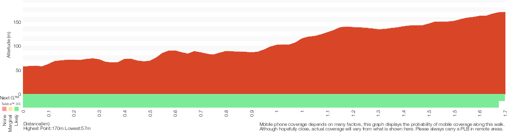
Analysis and summary of the altitude variation on the Glasson’s Trail
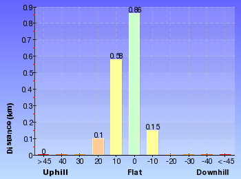
Overview of this walks grade – based on the AS 2156.1 – 2001
Under this standard, a walk is graded based on the most difficult section of the walk.
| Length | 1.7 km | ||
| Time | 1 Hr | ||
| . | |||
| Grade 3/6 Moderate track |
AS 2156.1 | Gradient | Short steep hills (3/6) |
| Quality of track | Formed track, with some branches and other obstacles (3/6) | ||
| Signs | Clearly signposted (1/6) | ||
| Experience Required | No experience required (1/6) | ||
| Weather | Weather generally has little impact on safety (1/6) | ||
| Infrastructure | Generally useful facilities (such as fenced cliffs and seats) (1/6) |
Some more details of this walks Grading
Here is a bit more details explaining grading looking at sections of the walk
Gradient
1000m of this walk has gentle hills with occasional steps and another 650m has short steep hills. The remaining (50m) is flat with no steps.
Quality of track
870m of this walk follows a clear and well formed track or trail and another 650m follows a formed track, with some branches and other obstacles. The remaining (180m) follows a smooth and hardened path.
Signs
This whole walk, 1.7km is clearly signposted.
Experience Required
This whole walk, 1.7km requires no previous bushwalking experience.
weather
This whole walk, 1.7km is not usually affected by severe weather events (that would unexpectedly impact safety and navigation).
Infrastructure
This whole walk, 1.7km is close to useful facilities (such as fenced cliffs and seats).
Similar walks
A list of walks that share part of the track with the Glasson’s Trail walk.
962 m Circuit
30 mins
Moderate track
4.5 km One way
2 hrs
Hard track
Other Nearby walks
A list of walks that start near the Glasson’s Trail walk.
4.1 km One way
1 hr 45 mins
Hard track
1.5 km Return
30 mins
Easy track
922 m Return
20 mins
Easy track
1.3 km Circuit
30 mins
Easy track
3.2 km Return
1 hr 15 mins
Easy track
1.5 km One way
45 mins
Hard track
2.9 km Circuit
1 hr 30 mins
Hard track
2.2 km Return
1 hr 15 mins
Hard track
3 km Return
1 hr 30 mins
Hard track
2.2 km One way
1 Hr
Hard track
991 m One way
30 mins
Moderate track
1.7 km Circuit
45 mins
Moderate track
Plan your trip to and from the walk here
The Glasson’s Trail walk starts at the Glasson’s Car Park (gps: -33.463707, 151.37924)
Your transport options to Glasson’s Car Park are by;
![]() Bus. (get details)
Bus. (get details)
![]() Car. There is free parking available.
Car. There is free parking available.
(get details)
The Glasson’s Trail ends at the Mudbrick building car park (gps: -33.459138, 151.39182)
Your main transport option to Mudbrick building car park is by;
![]() Car. There is free parking available.
Car. There is free parking available.
(get details)
Short URL = http://wild.tl/2f
Gallery images
There are other downloads I am still working on.
You will probably need to login to access these — still all free.
* KML (google earth file)
* GPX (GPS file)
Special Maps/ brochures
* A3 topo maps
* PDF with Lands Topo map base
* PDF with arial image (and map overlay)
I wanted to get the main site live first, this extra stuff will come in time.
Happy walking
Matt 🙂
Sandringham Track
And Walk
Sandringham Track

1 hr 15 mins
2.2 km Return
149 m
Hard track
This walk starts from Terrigal suburbia and leads up through the dry bush to the wonderful views at Colin Watters Lookout. On the way, you pass some large boulders scattered with red gums and grass trees. At the top, you will be greeted with good views over Avoca, and a picnic table encouraging you to soak up the view.
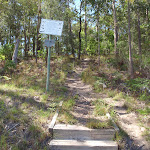
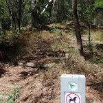

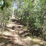


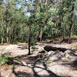
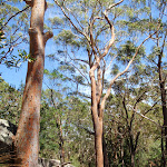
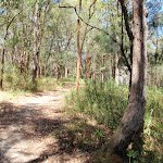


(0km) End of Sandringham Cl → Sandringham intersection
140 m
4 mins
33m
0m
Moderate track
From the end of Sandringham Cl, this walk heads up the concrete steps and path between houses number 7 and 9. At the back of the houses, the walk continues up the hill along the track and timber steps and, before long, the track passes between two timber barriers, coming to a wide management trail and a five-way intersection (just to the left).
(0.14km) Sandringham intersection → Sandringham Track clearing
690 m
18 mins
70m
-4m
Hard track
Turn right: From the intersection, this walk heads past the No Dogs sign and up the timbers steps, following the track up the spur away from the houses. The track heads steeply at first and then, at the top of the stairs, the track bends right and flattens out. After about 150m, the track starts to head uphill again and, just past a large dead tree, the walk turns left at a ‘T’ intersection to head up along the ridge. After another 120m, the walk ignores a side track (on the right) and continues up the ridge for just over 100m to a small clearing and intersection with a management trail.
(0.82km) Sandringham Track clearing → Tower intersection
170 m
6 mins
30m
0m
Hard track
Veer left: From the intersection, this walk follows the narrow track up the ridge (initially keeping the management trail below and to the right). The track heads towards the rocky outcrop and bends left, keeping the rocks on the right. The track leads between the gums and grass trees, with filtered views to the left. The track makes its way around the rock to a flat area at the top. From here, the track continues gently up the hill along to top of the ridge for about 60m, to a four-way intersection near the large tower.
(1km) Tower intersection → Colin Watters Lookout
110 m
3 mins
0m
-12m
Moderate track
Turn left: From the intersection, this walk heads south-east away from the tower and gently down hill. The track soon ignores another track (on the left) and gently bends to the right, coming to the fenced and signposted ‘Colin Watters Lookout’[1].
Colin Watters Lookout
A plaque[2] explains that this lookout was named in 1992 in honour of the Colin D Watters, who was Senior Parks Supervisor with Gosford Council. The fenced[3] lookout provides great view south-east, down Picketts Valley to Avoca Lake and Beach[4]. The lookout is also home to an information board[5], bench seat[6], picnic table and garbage bin[7]. This lookout offers one of the best views in the park and makes a great spot to stop and rest.
Maps for the Sandringham Track walk
You can download the PDF for this walk to print a map.
These maps below cover the walk and the wider area around the walk, they are worth carrying for safety reasons.
| Gosford | 1:25 000 Map Series | 91312S GOSFORD | NSW-91312S |
| Gosford | 1:100 000 Map Series | 9131 GOSFORD | 9131 |
Cross sectional view of the Sandringham Track bushwalking track
Analysis and summary of the altitude variation on the Sandringham Track
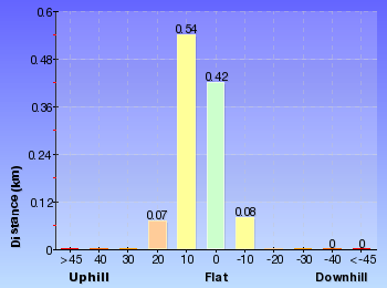
Overview of this walks grade – based on the AS 2156.1 – 2001
Under this standard, a walk is graded based on the most difficult section of the walk.
| Length | 2.2 km | ||
| Time | 1 hr 15 mins | ||
| . | |||
| Grade 4/6 Hard track |
AS 2156.1 | Gradient | Very steep (4/6) |
| Quality of track | Formed track, with some branches and other obstacles (3/6) | ||
| Signs | Minimal directional signs (4/6) | ||
| Experience Required | Moderate level of bushwalking experience recommended (4/6) | ||
| Weather | Weather generally has little impact on safety (1/6) | ||
| Infrastructure | Generally useful facilities (such as fenced cliffs and seats) (1/6) |
Some more details of this walks Grading
Here is a bit more details explaining grading looking at sections of the walk
Gradient
860m of this walk is very steep and another 140m has short steep hills. The remaining (110m) has gentle hills with occasional steps.
Quality of track
Around 1000m of this walk follows a formed track, with some branches and other obstacles, whilst the remaining 110m follows a clear and well formed track or trail.
Signs
Around 940m of this walk has directional signs at most intersection, whilst the remaining 170m has minimal directional signs.
Experience Required
Around 940m of this walk requires some bushwalking experience, whilst the remaining 170m requires a leader a with moderate level of bushwalking experience.
weather
This whole walk, 1.1km is not usually affected by severe weather events (that would unexpectedly impact safety and navigation).
Infrastructure
This whole walk, 1.1km is close to useful facilities (such as fenced cliffs and seats).
Similar walks
A list of walks that share part of the track with the Sandringham Track walk.
2.9 km Circuit
1 hr 30 mins
Hard track
4.5 km One way
2 hrs
Hard track
Other Nearby walks
A list of walks that start near the Sandringham Track walk.
1.5 km One way
45 mins
Hard track
922 m Return
20 mins
Easy track
1.3 km Circuit
30 mins
Easy track
3.2 km Return
1 hr 15 mins
Easy track
962 m Circuit
30 mins
Moderate track
4.1 km One way
1 hr 45 mins
Hard track
1.5 km Return
30 mins
Easy track
1.7 km One way
1 Hr
Moderate track
5.3 km Circuit
2 hrs 45 mins
Moderate track
8.5 km One way
3 hrs 45 mins
Hard track
2 km Return
1 Hr
Moderate track
890 m Return
30 mins
Easy track
Plan your trip to and from the walk here
The Sandringham Track walk starts and ends at the End of Sandringham Cl (gps: -33.444669, 151.40678)
Your transport options to End of Sandringham Cl are by;
![]() Bus. (get details)
Bus. (get details)
![]() Car. There is free parking available.
Car. There is free parking available.
(get details)
Short URL = http://wild.tl/2g
Gallery images
There are other downloads I am still working on.
You will probably need to login to access these — still all free.
* KML (google earth file)
* GPX (GPS file)
Special Maps/ brochures
* A3 topo maps
* PDF with Lands Topo map base
* PDF with arial image (and map overlay)
I wanted to get the main site live first, this extra stuff will come in time.
Happy walking
Matt 🙂
Comments