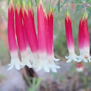
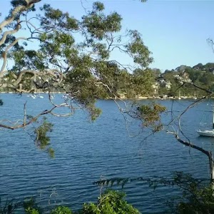
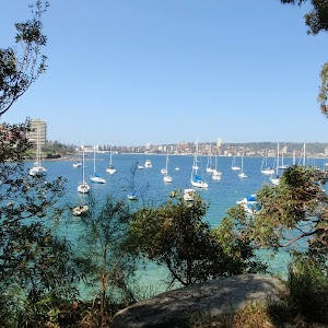
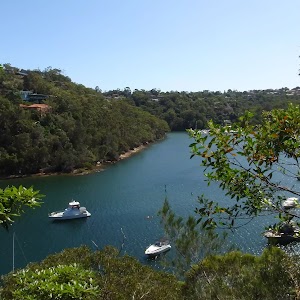
A short walk along the southern hill above Manly Dam, with great views and fantastic scenery. One of the few tracks in the Manly Dam area where you won’t get run over by bike riders, this is a great walk for those looking for something short and peaceful. Look out for black snakes and goannas along the way, especially in the McComb Hill area.
Manly Dam Nature Trail
And Walk
Manly Dam Nature Trail


1 hr 30 mins
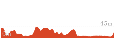
3.2 km Return

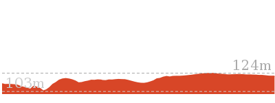
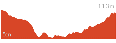
150 m
Moderate track


(0km) Manly Dam South Bank → Int of Water Reserve Bushtrack and Nature Trail

140 m
3 mins
12m
0m
Moderate track
From the south end of Manly Dam, this walk heads south through the park and crosses King St near the car parking area. The walk follows the bush track up the steps, following the signs ‘McComb Hill Track’ and ‘Nature Trail’. A short way up the hill, the track comes to an intersection signposted as the ‘Mc Comb Hill Nature Trail’.
(0.14km) Int of Water Reserve Bushtrack and Nature Trail → Int of Nature Trail and North Balgowlah track
920 m
22 mins
60m
-37m
Moderate track
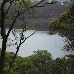
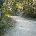
Turn right: From the intersection, this walk heads west along the narrow bush track for approximately 100m before passing an intersection of the McComb Hill walk. (This is currently under revegetation and there are signs stating walkers should not take this route.) This walk heads west, passing by the small trails that lead up the hill south (these are not official trails and should be avoided), and climbs a number of rock staircases. Along the way, there are some good views over Manly Dam, and many signs offering information on the flora and fauna. The track passes close to a few cliff edges (due care required). After some time, the walk comes to an intersection marked with a green sign saying ‘Balgowlah Track’.
(1.06km) Int of Nature Trail and North Balgowlah track → Int of Nature Trail and Wildflower walk
210 m
4 mins
1m
-20m
Moderate track
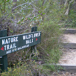
Turn right: From the intersection, this walk heads north, gradually descending along the narrow bush track. There are many informative signposts and some good examples of the flora of the local area. Soon the walk comes to a very clear intersection signposted as the “Nature Trail / Wildflower Walk”.
(1.27km) Int of Nature Trail and Wildflower walk → End of King St Picnic Area
310 m
6 mins
5m
-15m
Easy track
Turn left: From the intersection, this walk heads north along a narrow but well-maintained bush track, until coming to an intersection with a ‘Wildflower Walk’ signpost. (There is a small track off to the left heading up to Wakehurst Golf Course, ignore this). The walk continues to head north-west along the bush track until coming to an intersection just to the north of the end of the King St and a picnic area.
Maps for the Manly Dam Nature Trail walk
You can download the PDF for this walk to print a map.
These maps below cover the walk and the wider area around the walk, they are worth carrying for safety reasons.
| Parramatta River | 1:25 000 Map Series | 91303N PARRAMATTA RIVER | NSW-91303N |
| Sydney Heads | 1:25 000 Map Series | 91302N SYDNEY HEADS | NSW-91302N |
| Sydney | 1:100 000 Map Series | 9130 SYDNEY | 9130 |
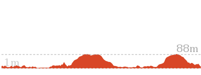
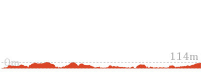
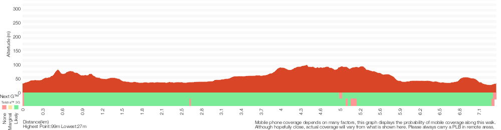
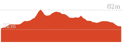
Cross sectional view of the Manly Dam Nature Trail bushwalking track
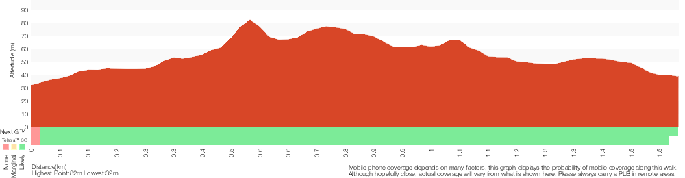
Analysis and summary of the altitude variation on the Manly Dam Nature Trail

Overview of this walks grade – based on the AS 2156.1 – 2001
Under this standard, a walk is graded based on the most difficult section of the walk.
| Length | 3.2 km | ||
| Time | 1 hr 30 mins | ||
| . | |||
| Grade 3/6 Moderate track |
AS 2156.1 | Gradient | Short steep hills (3/6) |
| Quality of track | Formed track, with some branches and other obstacles (3/6) | ||
| Signs | Clearly signposted (1/6) | ||
| Experience Required | Some bushwalking experience recommended (3/6) | ||
| Weather | Weather generally has little impact on safety (1/6) | ||
| Infrastructure | Limited facilities, not all cliffs are fenced (3/6) |
Some more details of this walks Grading
Here is a bit more details explaining grading looking at sections of the walk
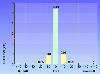
Gradient
Around 920m of this walk has short steep hills, whilst the remaining 660m has gentle hills with occasional steps.
Quality of track
Around 1.1km of this walk follows a formed track, with some branches and other obstacles, whilst the remaining 520m follows a clear and well formed track or trail.
Signs
This whole walk, 1.6km is clearly signposted.
Experience Required
Around 1.1km of this walk requires some bushwalking experience, whilst the remaining 450m requires no previous bushwalking experience.
weather
This whole walk, 1.6km is not usually affected by severe weather events (that would unexpectedly impact safety and navigation).
Infrastructure
Around 1.1km of this walk has limited facilities (such as not all cliffs fenced), whilst the remaining 450m is close to useful facilities (such as fenced cliffs and seats).
Similar walks
A list of walks that share part of the track with the Manly Dam Nature Trail walk.

7.3 km Circuit
3 hrs
Moderate track
Other Nearby walks
A list of walks that start near the Manly Dam Nature Trail walk.
2.2 km One way
45 mins
Moderate track
10 km One way
4 hrs 30 mins
Hard track

10 km One way
4 hrs
Hard track

5.4 km Return
3 hrs
Hard track
1.8 km Return
1 Hr
Hard track
516 m Return
20 mins
Moderate track
3.1 km One way
2 hrs
Moderate track
9.1 km One way
3 hrs 45 mins
Moderate track
8.7 km Circuit
4 hrs
Moderate track
6.1 km One way
2 hrs 30 mins
Hard track
22.6 km One way
9 hrs 45 mins
Hard track
3.6 km Circuit
1 hr 30 mins
Hard track
Plan your trip to and from the walk here
The Manly Dam Nature Trail walk starts and ends at the Manly Dam South Bank (gps: -33.782543, 151.25565)
Your transport options to Manly Dam South Bank are by;
![]() Bus. (get details)
Bus. (get details)
![]() Car. A park entry fee is required for driving into the park.
Car. A park entry fee is required for driving into the park.
(get details)


Short URL = http://wild.tl/mdnt
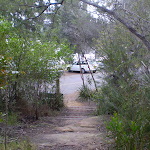
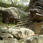
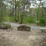
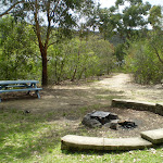
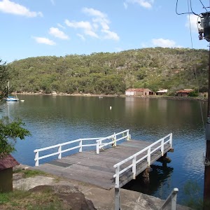
Gallery images
There are other downloads I am still working on.
You will probably need to login to access these — still all free.
* KML (google earth file)
* GPX (GPS file)
Special Maps/ brochures
* A3 topo maps
* PDF with Lands Topo map base
* PDF with arial image (and map overlay)
I wanted to get the main site live first, this extra stuff will come in time.
Happy walking
Matt 🙂
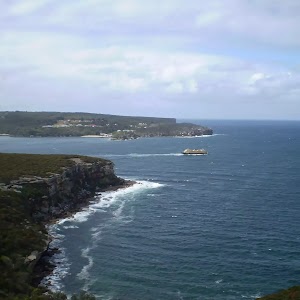
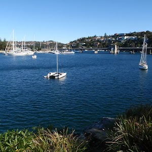
Manly Dam Circuit Walk
And Walk
Manly Dam Circuit Walk

3 hrs
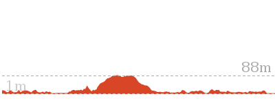
7.3 km Circuit
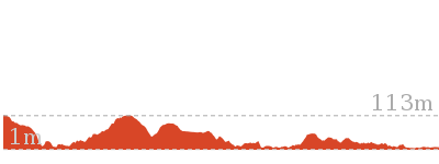
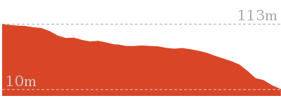
251 m
Moderate track
This is the main walk around Manly Dam, and is popular for both walkers and bike riders. Prepare for spectacular views from both sides of the dam, along well managed trails. Good spots to break include the picnic areas on King St. Features of this walk include walking the bridge across the top of the dam and the beach on the north side. Watch out for bike riders as this is a shared track. (This walk has changed since these notes were written, the track notes are now somewhat out of date sorry)


(0km) Manly Dam South Bank → Int of Water Reserve Bushtrack and Nature Trail
140 m
3 mins
12m
0m
Moderate track
From the south end of Manly Dam, this walk heads south through the park and crosses King St near the car parking area. The walk follows the bush track up the steps, following the signs ‘McComb Hill Track’ and ‘Nature Trail’. A short way up the hill, the track comes to an intersection signposted as the ‘Mc Comb Hill Nature Trail’.
(0.14km) Int of Water Reserve Bushtrack and Nature Trail → Int of Nature Trail and North Balgowlah track
920 m
22 mins
60m
-37m
Moderate track
Turn right: From the intersection, this walk heads west along the narrow bush track for approximately 100m before passing an intersection of the McComb Hill walk. (This is currently under revegetation and there are signs stating walkers should not take this route.) This walk heads west, passing by the small trails that lead up the hill south (these are not official trails and should be avoided), and climbs a number of rock staircases. Along the way, there are some good views over Manly Dam, and many signs offering information on the flora and fauna. The track passes close to a few cliff edges (due care required). After some time, the walk comes to an intersection marked with a green sign saying ‘Balgowlah Track’.
(1.06km) Int of Nature Trail and North Balgowlah track → End of King St Picnic Area
520 m
10 mins
6m
-35m
Moderate track
Turn right: From the intersection, this walk heads north, gradually descending along the narrow bush track. There are many informative signposts and some good examples of the flora of the local area. Soon the walk comes to a very clear intersection signposted as the “Nature Trail / Wildflower Walk”.
Turn left: From the intersection, this walk heads north along a narrow but well-maintained bush track, until coming to an intersection with a ‘Wildflower Walk’ signpost. (There is a small track off to the left heading up to Wakehurst Golf Course, ignore this). The walk continues to head north-west along the bush track until coming to an intersection just to the north of the end of the King St and a picnic area.
Turn left: From the intersection, this walk heads north along a narrow but well-maintained bush track, until coming to an intersection with a ‘Wildflower Walk’ signpost. (There is a small track off to the left heading up to Wakehurst Golf Course, ignore this). The walk continues to head north-west along the bush track until coming to an intersection just to the north of the end of the King St and a picnic area.
(1.58km) End of King St Picnic Area → Int of Circuit and Curl Curl Tracks
2 km
35 mins
40m
-19m
Moderate track
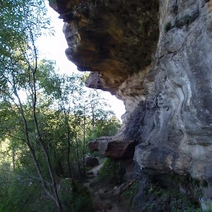
Turn left: From the picnic area,this walk heads alongside Manly Dam, following a narrow track with high vegetation on either side. The track crosses several wetter areas, where footbridges have been installed. At the end of Manly Dam, the walk follows the creek further north, past some waterfalls and holes – the smaller waterholes are quite picturesque. The main waterfall is quite sheltered by vegetation and somewhat hidden from the main track. The walk comes to an intersection with a wide management trail.
(3.57km) Int of Circuit and Curl Curl Tracks → Int of Circuit and Retirement Home Tracks
760 m
17 mins
46m
-14m
Moderate track
Turn right: From the intersection, this walk follows the ‘Circuit Track’ sign along the management trail, away from Wakehurst Parkway. The trail immediately bends to the right and crosses Manly Creek. Soon, it heads up a small hill and turns back to the south. The walk soon comes to an intersection with another management trail, uphill on the left.
(4.32km) Int of Circuit and Retirement Home Tracks → Int of Roosevelt Rd and Circuit Tracks
890 m
20 mins
45m
-46m
Moderate track
Continue straight: From the intersection, this walk heads south-east along the management trail, passing an intersection with a small track, before coming to an intersection with a track, and an ‘Allambie Heights Town Centre’ sign[1].
(5.21km) Int of Roosevelt Rd and Circuit Tracks → Int of Circuit and Southern Cross Servicetrail
900 m
18 mins
13m
-62m
Moderate track
Turn right: From the intersection, this walk heads south-east along the smaller track, downhill. The track bends to the north-east, making its way around a small inlet. The track crosses some wetter areas on boardwalk bridges, turning back to the south and soon coming to an intersection with another track on the left (that heads up to Southern Cross Way.)
(6.12km) Int of Circuit and Southern Cross Servicetrail → Int of Circuit and Nyrang Rd Tracks
320 m
6 mins
3m
-7m
Moderate track
Continue straight: From the intersection, this walk heads south along the track until reaching an intersection with a management trail, and ‘Nyrang Road’ signs[2].
(6.44km) Int of Circuit and Nyrang Rd Tracks → Int of King St Circuit Alternative Route and Circuit Track
570 m
11 mins
21m
-10m
Moderate track
Turn right: From the intersection, this walk heads west down the rough management trail, in the opposite direction to the ‘Nyrand Road’ arrow[3]. After approximately 100m, the trail comes to the beach on Manly Dam. The trail turns left and heads south along the waters’ edge, soon joining up with a boardwalk and track. The track then climbs gently away from the water, and comes to an intersection with another track, signposted ‘Alternate Track to Picnic Areas via King St’[4].
(7.01km) Int of King St Circuit Alternative Route and Circuit Track → Manly Dam North Bank
100 m
2 mins
0m
-15m
Moderate track
Turn right: From the intersection, this walk heads south, down the track towards the water until reaching the northern end of Manly Dam wall.
(7.11km) Manly Dam North Bank → Manly Dam South Bank
240 m
5 mins
5m
-10m
Easy track
Continue straight: From the northern bank of Manly Dam, this walk heads across the top of the dam wall, offering some impressive views of the dam and the parklands from very close to water level. The walk continues to the southern bank of the dam.
Maps for the Manly Dam Circuit Walk walk
You can download the PDF for this walk to print a map.
These maps below cover the walk and the wider area around the walk, they are worth carrying for safety reasons.
| Parramatta River | 1:25 000 Map Series | 91303N PARRAMATTA RIVER | NSW-91303N |
| Sydney Heads | 1:25 000 Map Series | 91302N SYDNEY HEADS | NSW-91302N |
| Sydney | 1:100 000 Map Series | 9130 SYDNEY | 9130 |
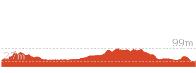
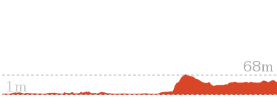
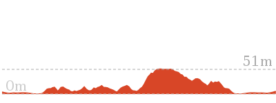
Cross sectional view of the Manly Dam Circuit Walk bushwalking track
Analysis and summary of the altitude variation on the Manly Dam Circuit Walk
Overview of this walks grade – based on the AS 2156.1 – 2001
Under this standard, a walk is graded based on the most difficult section of the walk.
| Length | 7.3 km | ||
| Time | 3 hrs | ||
| . | |||
| Grade 3/6 Moderate track |
AS 2156.1 | Gradient | Short steep hills (3/6) |
| Quality of track | Formed track, with some branches and other obstacles (3/6) | ||
| Signs | Directional signs along the way (3/6) | ||
| Experience Required | Some bushwalking experience recommended (3/6) | ||
| Weather | Weather generally has little impact on safety (1/6) | ||
| Infrastructure | Limited facilities, not all cliffs are fenced (3/6) |
Some more details of this walks Grading
Here is a bit more details explaining grading looking at sections of the walk
Gradient
Around 6km of this walk has short steep hills, whilst the remaining 890m has gentle hills with occasional steps.
Quality of track
Around 4.6km of this walk follows a clear and well formed track or trail, whilst the remaining 2.7km follows a formed track, with some branches and other obstacles.
Signs
Around 7km of this walk is clearly signposted, whilst the remaining 760m has directional signs at most intersection.
Experience Required
Around 4km of this walk requires some bushwalking experience, whilst the remaining 3.3km requires no previous bushwalking experience.
weather
This whole walk, 7km is not usually affected by severe weather events (that would unexpectedly impact safety and navigation).
Infrastructure
Around 7km of this walk has limited facilities (such as not all cliffs fenced), whilst the remaining 780m is close to useful facilities (such as fenced cliffs and seats).
Similar walks
A list of walks that share part of the track with the Manly Dam Circuit Walk walk.

3.2 km Return
1 hr 30 mins
Moderate track
Other Nearby walks
A list of walks that start near the Manly Dam Circuit Walk walk.
2.2 km One way
45 mins
Moderate track
10 km One way
4 hrs 30 mins
Hard track
10 km One way
4 hrs
Hard track
5.4 km Return
3 hrs
Hard track
1.8 km Return
1 Hr
Hard track
516 m Return
20 mins
Moderate track
3.1 km One way
2 hrs
Moderate track
9.1 km One way
3 hrs 45 mins
Moderate track
8.7 km Circuit
4 hrs
Moderate track
6.1 km One way
2 hrs 30 mins
Hard track
22.6 km One way
9 hrs 45 mins
Hard track
3.6 km Circuit
1 hr 30 mins
Hard track
Plan your trip to and from the walk here
The Manly Dam Circuit Walk walk starts and ends at the Manly Dam South Bank (gps: -33.782543, 151.25565)
Your transport options to Manly Dam South Bank are by;
![]() Bus. (get details)
Bus. (get details)
![]() Car. Parking fees apply in the area.
Car. Parking fees apply in the area.
(get details)
Short URL = http://wild.tl/mdcw
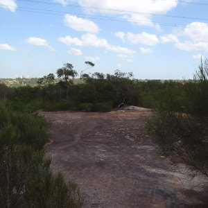
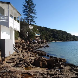
Gallery images
There are other downloads I am still working on.
You will probably need to login to access these — still all free.
* KML (google earth file)
* GPX (GPS file)
Special Maps/ brochures
* A3 topo maps
* PDF with Lands Topo map base
* PDF with arial image (and map overlay)
I wanted to get the main site live first, this extra stuff will come in time.
Happy walking
Matt 🙂
Comments