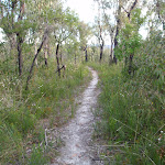
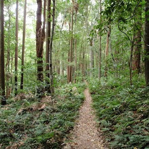
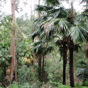
A great circuit walk in Popran National Park, to the beautiful Emerald Pool. This walk passes through a variety of vegetation and offers some great views along the way. Emerald Pool is a really beautiful spot and it is well worth spending some time exploring around the creek. The optional side trips along the 248 trail and to Mt Olive, add to the great views on the walk. If your car has reasonable ground clearance, you could drive to the Ironbark picnic area and start the walk from there.
Emerald Pool circuit from Ironbark Rd


4 hrs 15 mins
10.8 km Circuit

344 m
Hard track


(0km) Int of Ironbark Rd and Popran Pipeline Trail → Ironbark Rd picnic area

1.7 km
35 mins
88m
-19m
Easy track
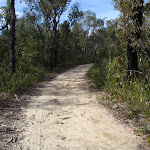
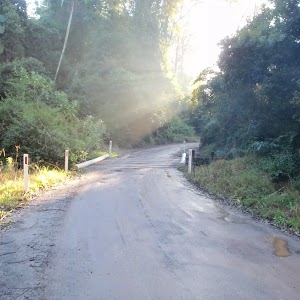
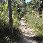
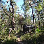
Starting from the car park at the end of the ‘Pipeline Trail’, the walk follows the gravel Ironbark Rd south, initially keeping the ‘Pipeline Trail’ gate to your left (not following the ‘Pipeline Trail’). The gravel road passes between some houses with prominent ‘private property’ signs so stick to the road along here. The walk eventually comes to the car park and picnic area at the end of the road. Vehicles with reasonable ground clearance could be driven along this section, to the car park at the end of the road.
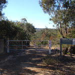
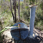
Ironbark Rd Picnic area
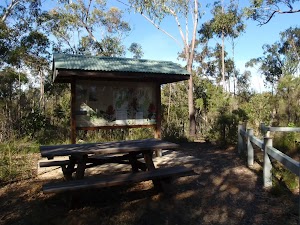
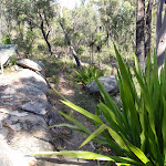
This picnic area is located at the end of Ironbark Rd, on the edge of Popran National Park. While this is not a special spot for a picnic, there are good facilities if you are doing a walk in the area. There is a picnic table, pit toilet (with a small rainwater tank for handwashing), information signs and track arrows at this point. Some of the tracks starting from this point are also horse trails. A section of Ironbark Rd may not be suitable for 2WD vehicles so you may have to walk the last section of road.
(1.7km) Ironbark Rd picnic area → Int of Mt Olive trail and 248 Trail
310 m
6 mins
10m
-10m
Easy track
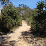
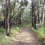
Continue straight: From the car park, the walk passes around a gate and follows the management trail down the hill and soon arrives at the intersection marked with ‘Mt Olive’ and the ‘248 Trail’.
(2.01km) Int of Mt Olive trail and 248 Trail → Int of Hominy Creek Trail and 248 Trail
1.5 km
29 mins
21m
-75m
Moderate track
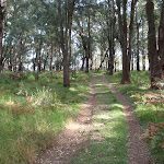
Veer right: From the intersection, the walk follows the ‘248 Trail’ arrow along the management trail. The trail meanders for a while and descends gently before passing through the signposted ‘Donovans Forest’. After climbing from ‘Donovans Forest’ and meandering a little further, the trail arrives at the signposted intersection of the ‘Hominy Creek Trail’ and the ‘248 Trail’.
(3.54km) Int of Hominy Creek Trail and 248 Trail → End of 248 Trail
600 m
12 mins
24m
-8m
Moderate track
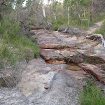
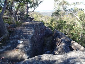
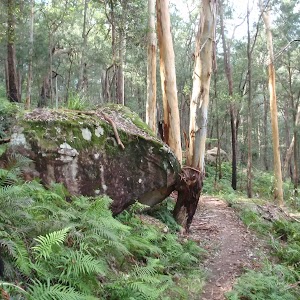
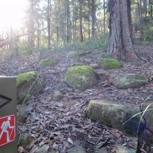
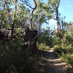
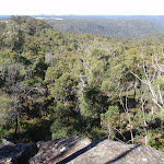
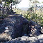
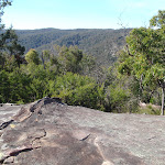
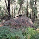
Veer right: From the intersection, the walk follows the ‘248 Trail’ arrow along the overgrown management trail, going gently up the hill. The track ends at a large rocky outcrop which is interesting to explore and has some nice views. At the end of this side trip, retrace your steps back to the main walk then Turn right.
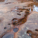
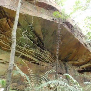
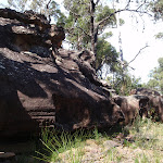
End of 248 Trail lookout
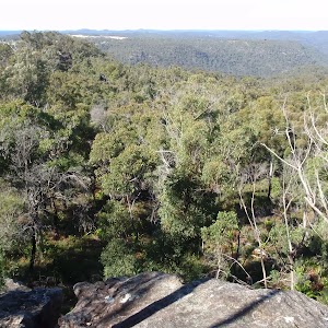
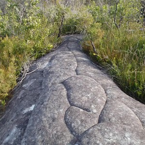
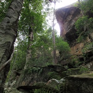
This informal lookout is located at the end of the 248 trail in Popran National Park. The lookout offers some nice views into the surrounding valleys. The rocky outcrops in the area have some nice shapes and textures. Be careful to avoid damaging some faint Aboriginal carvings on these rocks.
(3.54km) Int of Hominy Creek Trail and 248 Trail → No Horses signpost
460 m
8 mins
4m
-7m
Moderate track
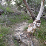
Veer left: From the intersection, the walk follows the ‘Hominy Creek Trail’ arrow along the management trail until arriving at the ‘No horses beyond this point’ signpost, where the increasingly overgrown management trail becomes a bush track.
(4km) No Horses signpost → Hominy Creek crossing
1.2 km
24 mins
10m
-96m
Hard track
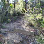
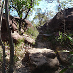
Continue straight: From the signpost, the walk follows the bush track leaving the signpost behind and to the right. This section of the walk descends gently passing through more swampy ground before dropping more steeply to arrive at the intersection of the ‘Hominy Creek Track’ and the ‘Emerald Pool’ track, beside Hominy Creek.
(5.24km) Hominy Creek crossing → Emerald Pool
110 m
2 mins
1m
-8m
Moderate track
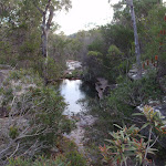
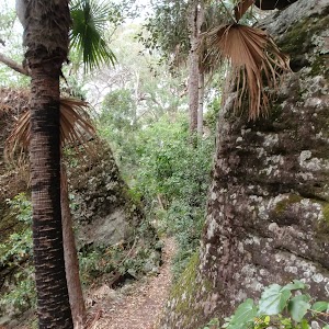
Veer right: From the intersection, the walk follows the ‘Emerald Pool’ arrow along the bush track, keeping the creek to the left. The walk soon arrives at the beautiful Emerald Pool.
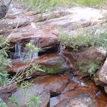
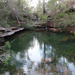
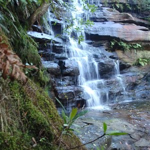
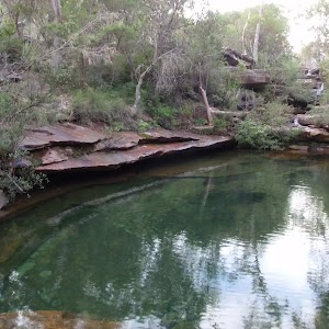
Emerald Pool

Emerald Pool is a beautiful spot on Hominy Creek in Popran National Park. This deep pool has crystal clear water with an emerald/green tinge. There is a nice little cascade falling into the pool and it is a great spot for lunch while doing one of the walks in the area.
(5.35km) Emerald Pool → End of Hominy Creek management trail
480 m
11 mins
43m
-1m
Moderate track
Turn around: From the Emerald Pool, the walk follows the bush track, keeping the creek to the right, for a short distance before arriving at an intersection with another bush track at a creek crossing.
Turn right: From the intersection, the walk crosses the creek and follows the ‘Hominy Creek Track’ arrow up the hill (from the opposite side of the creek to the Emarald Pool track). The walk climbs and meanders for a while before reaching the end of a management trail, signposted with ‘Hominy Creek Track’, ‘No horses beyond this point’ and others.
Turn right: From the intersection, the walk crosses the creek and follows the ‘Hominy Creek Track’ arrow up the hill (from the opposite side of the creek to the Emarald Pool track). The walk climbs and meanders for a while before reaching the end of a management trail, signposted with ‘Hominy Creek Track’, ‘No horses beyond this point’ and others.
(5.83km) End of Hominy Creek management trail → Int of Mt Olive trail and Mt Olive bush track
3 km
1 Hr
137m
-31m
Moderate track
Continue straight: From the intersection, the walk follows the management trail up the hill and arrives at an intersection with the ‘Mt Olive Trail’.
Continue straight: From the intersection, the walk follows the ‘Carpark 2.7km’ arrow along the management trail, going up the hill. The walk climbs gently and meanders for some distance, offering nice views along the way, before arriving at an intersection with a bush track (signposted ‘Mt Olive’).
Continue straight: From the intersection, the walk follows the ‘Carpark 2.7km’ arrow along the management trail, going up the hill. The walk climbs gently and meanders for some distance, offering nice views along the way, before arriving at an intersection with a bush track (signposted ‘Mt Olive’).
(8.78km) Int of Mt Olive trail and Mt Olive bush track → Top of Mt Olive
190 m
5 mins
22m
-1m
Hard track
Turn right: From the intersection, the walk follows the ‘Mt Olive’ signpost along the bush track. The walk meanders for a while before reaching an intersection with another bush track.
Turn left: From the intersection, the walk follows the bush track steeply up the hill and soon arrives at the top of Mt Olive. At the end of this side trip, retrace your steps back to the main walk then Turn right.
Turn left: From the intersection, the walk follows the bush track steeply up the hill and soon arrives at the top of Mt Olive. At the end of this side trip, retrace your steps back to the main walk then Turn right.
Mt Olive
Mt Olive is a low rising hill in Popran National Park. The views from the top, across the surrounding national park, in all directions, are very nice. The nice cliffs around the base of Mt Olive also add to the scenery. There are the remnants of a couple of old trig points at the top.
(8.78km) Int of Mt Olive trail and Mt Olive bush track → Int of Ironbark Rd and Popran Pipeline Trail
2 km
41 mins
30m
-98m
Moderate track
Continue straight: From the intersection, the walk follows the management trail gently up the hill, leaving the ‘Mt Olive’ signpost on the right. After a very short distance the trail arrives at the intersection signposted with ‘Mt Olive’ and the ‘248 Trail’.
Turn right: From the intersection, the walk follows the management trail past the ‘Way Out’ signpost and immediately bends to the right. The walk soon passes around a gate and arrives at the car park.
Continue straight: From the car park, the walk follows the road, passing some ‘private property’ and eventually arrives at another car park at the end of the signposted ‘Pipeline Track’.
Maps for the Emerald Pool circuit from Ironbark Rd walk
You can download the PDF for this walk to print a map.
These maps below cover the walk and the wider area around the walk, they are worth carrying for safety reasons.
| Gunderman | 1:25 000 Map Series | 91313S GUNDERMAN | NSW-91313S |
| Mangrove | 1:25 000 Map Series | 91313N MANGROVE | NSW-91313N |
| Gosford | 1:100 000 Map Series | 9131 GOSFORD | 9131 |
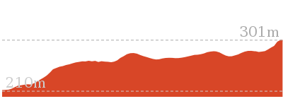
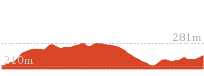
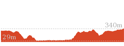
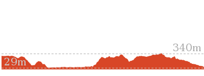
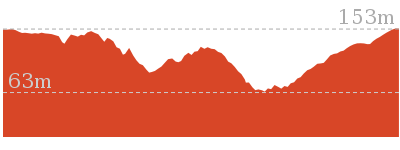
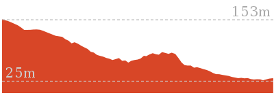
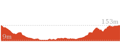
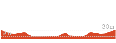
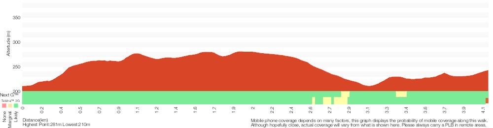
Cross sectional view of the Emerald Pool circuit from Ironbark Rd bushwalking track
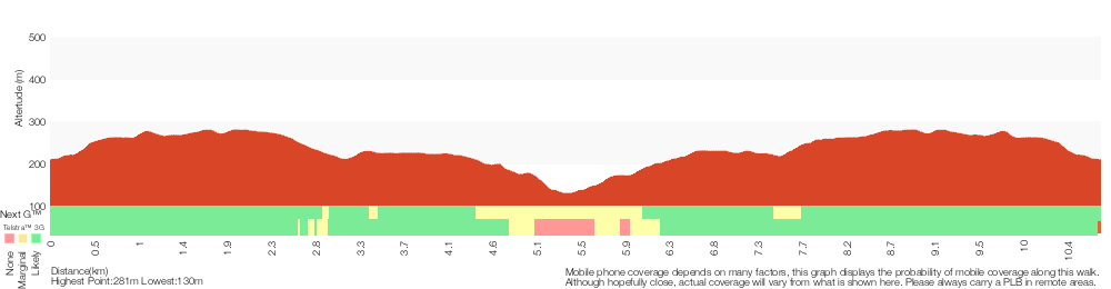
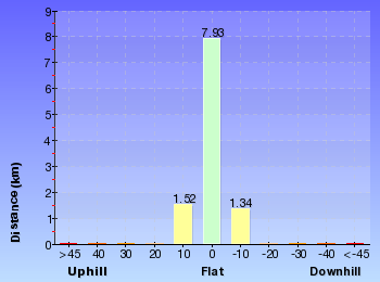
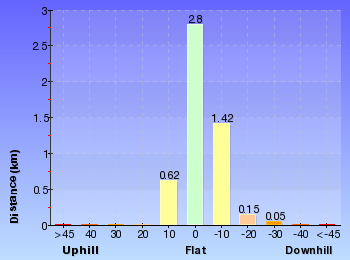
Analysis and summary of the altitude variation on the Emerald Pool circuit from Ironbark Rd
Overview of this walks grade – based on the AS 2156.1 – 2001
Under this standard, a walk is graded based on the most difficult section of the walk.
| Length | 10.8 km | ||
| Time | 4 hrs 15 mins | ||
| . | |||
| Grade 4/6 Hard track |
AS 2156.1 | Gradient | Very steep (4/6) |
| Quality of track | Rough track, where fallen trees and other obstacles are likely (4/6) | ||
| Signs | Directional signs along the way (3/6) | ||
| Experience Required | Some bushwalking experience recommended (3/6) | ||
| Weather | Storms may impact on navigation and safety (3/6) | ||
| Infrastructure | Limited facilities, not all cliffs are fenced (3/6) |
Some more details of this walks Grading
Here is a bit more details explaining grading looking at sections of the walk
Gradient
9km of this walk has gentle hills with occasional steps and another 1.2km is very steep. Whilst another 940m has short steep hills and the remaining 25m is flat with no steps.
Quality of track
9km of this walk follows a clear and well formed track or trail and another 1.2km follows a rough track, where fallen trees and other obstacles are likely. The remaining (590m) follows a formed track, with some branches and other obstacles.
Signs
Around 7km of this walk has directional signs at most intersection, whilst the remaining 4km is clearly signposted.
Experience Required
Around 9km of this walk requires no previous bushwalking experience, whilst the remaining 2.3km requires some bushwalking experience.
weather
Around 9km of this walk is not usually affected by severe weather events (that would unexpectedly impact safety and navigation), whilst the remaining 1.8km is affected by storms that may impact your navigation and safety.
Infrastructure
Around 7km of this walk has limited facilities (such as not all cliffs fenced), whilst the remaining 4km is close to useful facilities (such as fenced cliffs and seats).
Similar walks
A list of walks that share part of the track with the Emerald Pool circuit from Ironbark Rd walk.
4.4 km Return
2 hrs
Hard track
8.3 km Return
3 hrs 15 mins
Moderate track
10.1 km Return
4 hrs 15 mins
Hard track
Other Nearby walks
A list of walks that start near the Emerald Pool circuit from Ironbark Rd walk.

6 km One way
2 hrs 30 mins
Hard track
21.1 km One way
8 hrs
Hard track
47.4 km One way
3 Days
Hard track
26.7 km One way
2 Days
Hard track
1.7 km Return
45 mins
Moderate track
3 km Circuit
1 hr 30 mins
Moderate track
1.7 km Circuit
1 Hr
Moderate track
2.2 km One way
1 Hr
Moderate track
1.8 km Circuit
1 Hr
Moderate track
8.1 km Circuit
3 hrs 30 mins
Moderate track
426 m Return
20 mins
Moderate track
2.3 km Circuit
1 Hr
Moderate track
Plan your trip to and from the walk here
The Emerald Pool circuit from Ironbark Rd walk starts and ends at the Int of Ironbark Rd and Popran Pipeline Trail (gps: -33.37159, 151.19528)
Your main transport option to Int of Ironbark Rd and Popran Pipeline Trail is by;
![]() Car. There is free parking available.
Car. There is free parking available.
(get details)


Short URL = http://wild.tl/epcfir
Gallery images
There are other downloads I am still working on.
You will probably need to login to access these — still all free.
* KML (google earth file)
* GPX (GPS file)
Special Maps/ brochures
* A3 topo maps
* PDF with Lands Topo map base
* PDF with arial image (and map overlay)
I wanted to get the main site live first, this extra stuff will come in time.
Happy walking
Matt 🙂
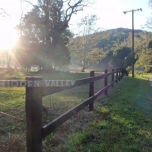
Popran Creek from Peats Ridge Rd
And Walk
This walk is closed. This walk passes through private property you must not attempt this walk as you will be trespassing. Please respect the landowners rights and do not trespass.

My apologies to the landowners for publishing this walk, I was not aware that it was on private property.
As an alternative please consider this walk.
10.8 km Circuit
4 hrs 15 mins
Hard track
Mt Olive
And Walk
Mt Olive

2 hrs
4.4 km Return
151 m
Hard track
(0km) Int of Ironbark Rd and Popran Pipeline Trail → Ironbark Rd picnic area
1.7 km
35 mins
88m
-19m
Easy track
Starting from the car park at the end of the ‘Pipeline Trail’, the walk follows the gravel Ironbark Rd south, initially keeping the ‘Pipeline Trail’ gate to your left (not following the ‘Pipeline Trail’). The gravel road passes between some houses with prominent ‘private property’ signs so stick to the road along here. The walk eventually comes to the car park and picnic area at the end of the road. Vehicles with reasonable ground clearance could be driven along this section, to the car park at the end of the road.
Ironbark Rd Picnic area
This picnic area is located at the end of Ironbark Rd, on the edge of Popran National Park. While this is not a special spot for a picnic, there are good facilities if you are doing a walk in the area. There is a picnic table, pit toilet (with a small rainwater tank for handwashing), information signs and track arrows at this point. Some of the tracks starting from this point are also horse trails. A section of Ironbark Rd may not be suitable for 2WD vehicles so you may have to walk the last section of road.
(1.7km) Ironbark Rd picnic area → Int of Mt Olive trail and Mt Olive bush track
340 m
6 mins
10m
-11m
Moderate track
Continue straight: From the car park, the walk passes around a gate and follows the management trail down the hill and soon arrives at the intersection marked with ‘Mt Olive’ and the ‘248 Trail’.
Turn left: From the intersection, the walk follows the ‘Mt Olive’ arrow along the management trail for a very short distance before reaching an intersection with a bush track signposted for ‘Mt Olive’.
Turn left: From the intersection, the walk follows the ‘Mt Olive’ arrow along the management trail for a very short distance before reaching an intersection with a bush track signposted for ‘Mt Olive’.
(2.03km) Int of Mt Olive trail and Mt Olive bush track → Top of Mt Olive
190 m
5 mins
22m
-1m
Hard track
Turn left: From the intersection, the walk follows the ‘Mt Olive’ signpost along the bush track. The walk meanders for a while before reaching an intersection with another bush track.
Turn left: From the intersection, the walk follows the bush track steeply up the hill and soon arrives at the top of Mt Olive.
Turn left: From the intersection, the walk follows the bush track steeply up the hill and soon arrives at the top of Mt Olive.
Mt Olive
Mt Olive is a low rising hill in Popran National Park. The views from the top, across the surrounding national park, in all directions, are very nice. The nice cliffs around the base of Mt Olive also add to the scenery. There are the remnants of a couple of old trig points at the top.
Maps for the Mt Olive walk
You can download the PDF for this walk to print a map.
These maps below cover the walk and the wider area around the walk, they are worth carrying for safety reasons.
| Gunderman | 1:25 000 Map Series | 91313S GUNDERMAN | NSW-91313S |
| Mangrove | 1:25 000 Map Series | 91313N MANGROVE | NSW-91313N |
| Gosford | 1:100 000 Map Series | 9131 GOSFORD | 9131 |
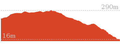
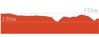
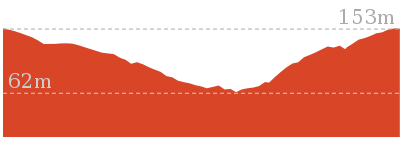
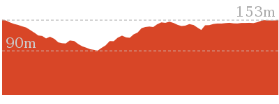
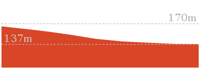
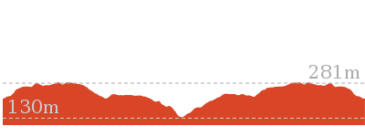
Cross sectional view of the Mt Olive bushwalking track

Analysis and summary of the altitude variation on the Mt Olive

Overview of this walks grade – based on the AS 2156.1 – 2001
Under this standard, a walk is graded based on the most difficult section of the walk.
| Length | 4.4 km | ||
| Time | 2 hrs | ||
| . | |||
| Grade 4/6 Hard track |
AS 2156.1 | Gradient | Short steep hills (3/6) |
| Quality of track | Rough track, where fallen trees and other obstacles are likely (4/6) | ||
| Signs | Minimal directional signs (4/6) | ||
| Experience Required | Some bushwalking experience recommended (3/6) | ||
| Weather | Weather generally has little impact on safety (1/6) | ||
| Infrastructure | Limited facilities, not all cliffs are fenced (3/6) |
Some more details of this walks Grading
Here is a bit more details explaining grading looking at sections of the walk
Gradient
2km of this walk has gentle hills with occasional steps and another 190m has short steep hills. The remaining (25m) is flat with no steps.
Quality of track
Around 2km of this walk follows a clear and well formed track or trail, whilst the remaining 190m follows a rough track, where fallen trees and other obstacles are likely.
Signs
2km of this walk is clearly signposted and another 150m has directional signs at most intersection. The remaining (60m) has minimal directional signs.
Experience Required
Around 2km of this walk requires no previous bushwalking experience, whilst the remaining 190m requires some bushwalking experience.
weather
This whole walk, 2.2km is not usually affected by severe weather events (that would unexpectedly impact safety and navigation).
Infrastructure
Around 2km of this walk is close to useful facilities (such as fenced cliffs and seats), whilst the remaining 210m has limited facilities (such as not all cliffs fenced).
Similar walks
A list of walks that share part of the track with the Mt Olive walk.
8.3 km Return
3 hrs 15 mins
Moderate track
10.1 km Return
4 hrs 15 mins
Hard track
10.8 km Circuit
4 hrs 15 mins
Hard track
Other Nearby walks
A list of walks that start near the Mt Olive walk.
6 km One way
2 hrs 30 mins
Hard track
21.1 km One way
8 hrs
Hard track
47.4 km One way
3 Days
Hard track
26.7 km One way
2 Days
Hard track
1.7 km Return
45 mins
Moderate track
3 km Circuit
1 hr 30 mins
Moderate track
1.7 km Circuit
1 Hr
Moderate track
2.2 km One way
1 Hr
Moderate track
1.8 km Circuit
1 Hr
Moderate track
8.1 km Circuit
3 hrs 30 mins
Moderate track
426 m Return
20 mins
Moderate track
2.3 km Circuit
1 Hr
Moderate track
Plan your trip to and from the walk here
The Mt Olive walk starts and ends at the Int of Ironbark Rd and Popran Pipeline Trail (gps: -33.37159, 151.19528)
Your main transport option to Int of Ironbark Rd and Popran Pipeline Trail is by;
![]() Car. There is free parking available.
Car. There is free parking available.
(get details)
Short URL = http://wild.tl/mo
Gallery images
There are other downloads I am still working on.
You will probably need to login to access these — still all free.
* KML (google earth file)
* GPX (GPS file)
Special Maps/ brochures
* A3 topo maps
* PDF with Lands Topo map base
* PDF with arial image (and map overlay)
I wanted to get the main site live first, this extra stuff will come in time.
Happy walking
Matt 🙂
248 Track
And Walk
248 Track

3 hrs 15 mins
8.3 km Return
255 m
Moderate track


(0km) Int of Ironbark Rd and Popran Pipeline Trail → Ironbark Rd picnic area
1.7 km
35 mins
88m
-19m
Easy track
Starting from the car park at the end of the ‘Pipeline Trail’, the walk follows the gravel Ironbark Rd south, initially keeping the ‘Pipeline Trail’ gate to your left (not following the ‘Pipeline Trail’). The gravel road passes between some houses with prominent ‘private property’ signs so stick to the road along here. The walk eventually comes to the car park and picnic area at the end of the road. Vehicles with reasonable ground clearance could be driven along this section, to the car park at the end of the road.
Ironbark Rd Picnic area
This picnic area is located at the end of Ironbark Rd, on the edge of Popran National Park. While this is not a special spot for a picnic, there are good facilities if you are doing a walk in the area. There is a picnic table, pit toilet (with a small rainwater tank for handwashing), information signs and track arrows at this point. Some of the tracks starting from this point are also horse trails. A section of Ironbark Rd may not be suitable for 2WD vehicles so you may have to walk the last section of road.
(1.7km) Ironbark Rd picnic area → Int of Mt Olive trail and 248 Trail
310 m
6 mins
10m
-10m
Easy track
Continue straight: From the car park, the walk passes around a gate and follows the management trail down the hill and soon arrives at the intersection marked with ‘Mt Olive’ and the ‘248 Trail’.
(2.01km) Int of Mt Olive trail and 248 Trail → Top of Mt Olive
210 m
5 mins
22m
-2m
Hard track
Turn left: From the intersection, the walk follows the ‘Mt Olive’ arrow along the management trail for a very short distance before reaching an intersection with a bush track signposted for ‘Mt Olive’.
Turn left: From the intersection, the walk follows the ‘Mt Olive’ signpost along the bush track. The walk meanders for a while before reaching an intersection with another bush track.
Turn left: From the intersection, the walk follows the bush track steeply up the hill and soon arrives at the top of Mt Olive. At the end of this side trip, retrace your steps back to the main walk then Turn left.
Mt Olive
Mt Olive is a low rising hill in Popran National Park. The views from the top, across the surrounding national park, in all directions, are very nice. The nice cliffs around the base of Mt Olive also add to the scenery. There are the remnants of a couple of old trig points at the top.
(2.01km) Int of Mt Olive trail and 248 Trail → End of 248 Trail
2.1 km
41 mins
45m
-83m
Moderate track
Veer right: From the intersection, the walk follows the ‘248 Trail’ arrow along the management trail. The trail meanders for a while and descends gently before passing through the signposted ‘Donovans Forest’. After climbing from ‘Donovans Forest’ and meandering a little further, the trail arrives at the signposted intersection of the ‘Hominy Creek Trail’ and the ‘248 Trail’.
Veer right: From the intersection, the walk follows the ‘248 Trail’ arrow along the overgrown management trail, going gently up the hill. The track ends at a large rocky outcrop which is interesting to explore and has some nice views.
Veer right: From the intersection, the walk follows the ‘248 Trail’ arrow along the overgrown management trail, going gently up the hill. The track ends at a large rocky outcrop which is interesting to explore and has some nice views.
End of 248 Trail lookout
This informal lookout is located at the end of the 248 trail in Popran National Park. The lookout offers some nice views into the surrounding valleys. The rocky outcrops in the area have some nice shapes and textures. Be careful to avoid damaging some faint Aboriginal carvings on these rocks.
Maps for the 248 Track walk
You can download the PDF for this walk to print a map.
These maps below cover the walk and the wider area around the walk, they are worth carrying for safety reasons.
| Gunderman | 1:25 000 Map Series | 91313S GUNDERMAN | NSW-91313S |
| Mangrove | 1:25 000 Map Series | 91313N MANGROVE | NSW-91313N |
| Gosford | 1:100 000 Map Series | 9131 GOSFORD | 9131 |
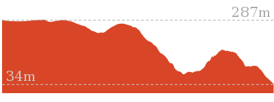
Cross sectional view of the 248 Track bushwalking track
Analysis and summary of the altitude variation on the 248 Track
Overview of this walks grade – based on the AS 2156.1 – 2001
Under this standard, a walk is graded based on the most difficult section of the walk.
| Length | 8.3 km | ||
| Time | 3 hrs 15 mins | ||
| . | |||
| Grade 3/6 Moderate track |
AS 2156.1 | Gradient | Gentle hills with occasional steps (2/6) |
| Quality of track | Formed track, with some branches and other obstacles (3/6) | ||
| Signs | Directional signs along the way (3/6) | ||
| Experience Required | No experience required (1/6) | ||
| Weather | Weather generally has little impact on safety (1/6) | ||
| Infrastructure | Limited facilities, not all cliffs are fenced (3/6) |
Some more details of this walks Grading
Here is a bit more details explaining grading looking at sections of the walk
Gradient
Around 3.5km of this walk has gentle hills with occasional steps, whilst the remaining 600m is flat with no steps.
Quality of track
Around 3.5km of this walk follows a clear and well formed track or trail, whilst the remaining 600m follows a formed track, with some branches and other obstacles.
Signs
Around 2.1km of this walk has directional signs at most intersection, whilst the remaining 2km is clearly signposted.
Experience Required
This whole walk, 4.1km requires no previous bushwalking experience.
weather
This whole walk, 4.1km is not usually affected by severe weather events (that would unexpectedly impact safety and navigation).
Infrastructure
Around 2.1km of this walk has limited facilities (such as not all cliffs fenced), whilst the remaining 2km is close to useful facilities (such as fenced cliffs and seats).
Similar walks
A list of walks that share part of the track with the 248 Track walk.
4.4 km Return
2 hrs
Hard track
10.1 km Return
4 hrs 15 mins
Hard track
10.8 km Circuit
4 hrs 15 mins
Hard track
Other Nearby walks
A list of walks that start near the 248 Track walk.
6 km One way
2 hrs 30 mins
Hard track
21.1 km One way
8 hrs
Hard track
47.4 km One way
3 Days
Hard track
26.7 km One way
2 Days
Hard track
1.7 km Return
45 mins
Moderate track
3 km Circuit
1 hr 30 mins
Moderate track
1.7 km Circuit
1 Hr
Moderate track
2.2 km One way
1 Hr
Moderate track
1.8 km Circuit
1 Hr
Moderate track
8.1 km Circuit
3 hrs 30 mins
Moderate track
426 m Return
20 mins
Moderate track
2.3 km Circuit
1 Hr
Moderate track
Plan your trip to and from the walk here
The 248 Track walk starts and ends at the Int of Ironbark Rd and Popran Pipeline Trail (gps: -33.37159, 151.19528)
Your main transport option to Int of Ironbark Rd and Popran Pipeline Trail is by;
![]() Car. There is free parking available.
Car. There is free parking available.
(get details)
Short URL = http://wild.tl/2t
Gallery images
There are other downloads I am still working on.
You will probably need to login to access these — still all free.
* KML (google earth file)
* GPX (GPS file)
Special Maps/ brochures
* A3 topo maps
* PDF with Lands Topo map base
* PDF with arial image (and map overlay)
I wanted to get the main site live first, this extra stuff will come in time.
Happy walking
Matt 🙂
Ironbark Rd to Glenworth Valley
And Walk
Ironbark Rd to Glenworth Valley

4 hrs 15 mins
10.1 km Return
492 m
Hard track
This walk, mostly in Popran National Park, passes through a great variety of scenery and beautiful views. The early part of the walk, along a ridgetop, is through relatively dry forest with some great views, while the steep but beautiful descent to Glenworth Valley is through moist, fern filled forest. The cafe at Glenworth Valley is open on weekends. There is also an optional sidetrip for some nice views from Mt Olive.


(0km) Int of Ironbark Rd and Popran Pipeline Trail → Ironbark Rd picnic area
1.7 km
35 mins
88m
-19m
Easy track
Starting from the car park at the end of the ‘Pipeline Trail’, the walk follows the gravel Ironbark Rd south, initially keeping the ‘Pipeline Trail’ gate to your left (not following the ‘Pipeline Trail’). The gravel road passes between some houses with prominent ‘private property’ signs so stick to the road along here. The walk eventually comes to the car park and picnic area at the end of the road. Vehicles with reasonable ground clearance could be driven along this section, to the car park at the end of the road.
Ironbark Rd Picnic area
This picnic area is located at the end of Ironbark Rd, on the edge of Popran National Park. While this is not a special spot for a picnic, there are good facilities if you are doing a walk in the area. There is a picnic table, pit toilet (with a small rainwater tank for handwashing), information signs and track arrows at this point. Some of the tracks starting from this point are also horse trails. A section of Ironbark Rd may not be suitable for 2WD vehicles so you may have to walk the last section of road.
(1.7km) Ironbark Rd picnic area → Int of Mt Olive trail and Mt Olive bush track
340 m
6 mins
10m
-11m
Moderate track
Continue straight: From the car park, the walk passes around a gate and follows the management trail down the hill and soon arrives at the intersection marked with ‘Mt Olive’ and the ‘248 Trail’.
Turn left: From the intersection, the walk follows the ‘Mt Olive’ arrow along the management trail for a very short distance before reaching an intersection with a bush track signposted for ‘Mt Olive’.
Turn left: From the intersection, the walk follows the ‘Mt Olive’ arrow along the management trail for a very short distance before reaching an intersection with a bush track signposted for ‘Mt Olive’.
(2.03km) Int of Mt Olive trail and Mt Olive bush track → Int of Mt Olive bush track and Glenworth Valley track
120 m
3 mins
11m
0m
Hard track
Turn left: From the intersection, the walk follows the ‘Mt Olive’ signpost along the bush track. The walk meanders for a while before reaching an intersection with another bush track.
(2.15km) Int of Mt Olive bush track and Glenworth Valley track → Top of Mt Olive
60 m
2 mins
11m
-1m
Hard track
Turn left: From the intersection, the walk follows the bush track steeply up the hill and soon arrives at the top of Mt Olive. At the end of this side trip, retrace your steps back to the main walk then Veer left.
Mt Olive
Mt Olive is a low rising hill in Popran National Park. The views from the top, across the surrounding national park, in all directions, are very nice. The nice cliffs around the base of Mt Olive also add to the scenery. There are the remnants of a couple of old trig points at the top.
(2.15km) Int of Mt Olive bush track and Glenworth Valley track → Glenworth Valley
2.9 km
1 hr 3 mins
40m
-313m
Hard track
Turn right: From the intersection, the walk follows the bush track steeply down the hill, directly away from the top of Mt Olive. The walk follows the bush track for a long distance, through a beautiful variety of terrain and vegetation. The first section of the walk is along, or close to, the ridge line with some great views. The later section of the walk drops, steeply at times, into Glenworth Valley and is through more moist, fern covered forest. Take the sharp right fork beside a rock with a large ‘capstone’ to avoid a steeper section of the track. The scenery is beautiful on the descent. Ignore the bush track to the right when the walk passes through a gap in a fence, and follow the bush track straight ahead. The walk then comes to an intersection with the ‘Wilderness Trail’ horse riding trail on the edge of a large grassy clearing at the Glenworth Valley horse riding centre.
Veer right: From the intersection, the walk follows the horse riding trail down the hill and immediately bends to the right, toward the clearly visible main buildings of the Glenworth Valley horse riding centre. The walk soon arrives at Popran Rd beside the buildings.
Veer right: From the intersection, the walk follows the horse riding trail down the hill and immediately bends to the right, toward the clearly visible main buildings of the Glenworth Valley horse riding centre. The walk soon arrives at Popran Rd beside the buildings.
Glenworth Valley Horse Riding and Outdoor Adventures
The Glenworth Valley Horse Riding and Outdoor Adventure Centre is located at 69 Cooks Rd, Peats Ridge, NSW. Activities include Horse riding, Kayaking, Quad biking, Abseiling and camping. The Café is open on weekends and vending machines for drinks and snacks are available every day. There are toilets at the cafe. If you are walking to or from Glenworth Valley, keep in mind that it is private property and take care around the horses. Phone on (02) 4375 1222. More info.
Maps for the Ironbark Rd to Glenworth Valley walk
You can download the PDF for this walk to print a map.
These maps below cover the walk and the wider area around the walk, they are worth carrying for safety reasons.
| Gunderman | 1:25 000 Map Series | 91313S GUNDERMAN | NSW-91313S |
| Mangrove | 1:25 000 Map Series | 91313N MANGROVE | NSW-91313N |
| Gosford | 1:100 000 Map Series | 9131 GOSFORD | 9131 |
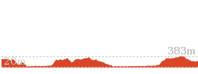
Cross sectional view of the Ironbark Rd to Glenworth Valley bushwalking track

Analysis and summary of the altitude variation on the Ironbark Rd to Glenworth Valley
Overview of this walks grade – based on the AS 2156.1 – 2001
Under this standard, a walk is graded based on the most difficult section of the walk.
| Length | 10.1 km | ||
| Time | 4 hrs 15 mins | ||
| . | |||
| Grade 4/6 Hard track |
AS 2156.1 | Gradient | Short steep hills (3/6) |
| Quality of track | Rough track, where fallen trees and other obstacles are likely (4/6) | ||
| Signs | Minimal directional signs (4/6) | ||
| Experience Required | Some bushwalking experience recommended (3/6) | ||
| Weather | Storms may impact on navigation and safety (3/6) | ||
| Infrastructure | Limited facilities, not all cliffs are fenced (3/6) |
Some more details of this walks Grading
Here is a bit more details explaining grading looking at sections of the walk
Gradient
2.9km of this walk has short steep hills and another 2.2km has gentle hills with occasional steps. The remaining (25m) is flat with no steps.
Quality of track
2.9km of this walk follows a formed track, with some branches and other obstacles and another 2km follows a clear and well formed track or trail. The remaining (120m) follows a rough track, where fallen trees and other obstacles are likely.
Signs
2.8km of this walk has minimal directional signs and another 2km is clearly signposted. The remaining (300m) has directional signs at most intersection.
Experience Required
Around 2.9km of this walk requires some bushwalking experience, whilst the remaining 2.2km requires no previous bushwalking experience.
weather
Around 2.8km of this walk is affected by storms that may impact your navigation and safety, whilst the remaining 2.3km is not usually affected by severe weather events (that would unexpectedly impact safety and navigation).
Infrastructure
Around 2.9km of this walk has limited facilities (such as not all cliffs fenced), whilst the remaining 2.2km is close to useful facilities (such as fenced cliffs and seats).
Similar walks
A list of walks that share part of the track with the Ironbark Rd to Glenworth Valley walk.
4.4 km Return
2 hrs
Hard track
8.3 km Return
3 hrs 15 mins
Moderate track
10.8 km Circuit
4 hrs 15 mins
Hard track
Other Nearby walks
A list of walks that start near the Ironbark Rd to Glenworth Valley walk.
6 km One way
2 hrs 30 mins
Hard track
21.1 km One way
8 hrs
Hard track
47.4 km One way
3 Days
Hard track
26.7 km One way
2 Days
Hard track
1.7 km Return
45 mins
Moderate track
3 km Circuit
1 hr 30 mins
Moderate track
1.7 km Circuit
1 Hr
Moderate track
2.2 km One way
1 Hr
Moderate track
1.8 km Circuit
1 Hr
Moderate track
8.1 km Circuit
3 hrs 30 mins
Moderate track
426 m Return
20 mins
Moderate track
2.3 km Circuit
1 Hr
Moderate track
Plan your trip to and from the walk here
The Ironbark Rd to Glenworth Valley walk starts and ends at the Int of Ironbark Rd and Popran Pipeline Trail (gps: -33.37159, 151.19528)
Your main transport option to Int of Ironbark Rd and Popran Pipeline Trail is by;
![]() Car. There is free parking available.
Car. There is free parking available.
(get details)
Short URL = http://wild.tl/irtgv
Gallery images
There are other downloads I am still working on.
You will probably need to login to access these — still all free.
* KML (google earth file)
* GPX (GPS file)
Special Maps/ brochures
* A3 topo maps
* PDF with Lands Topo map base
* PDF with arial image (and map overlay)
I wanted to get the main site live first, this extra stuff will come in time.
Happy walking
Matt 🙂
Comments