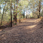
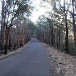
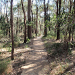
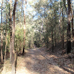
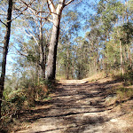
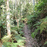
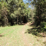
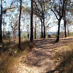
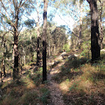
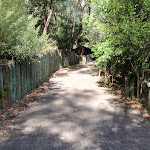
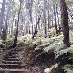
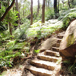
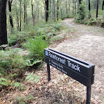
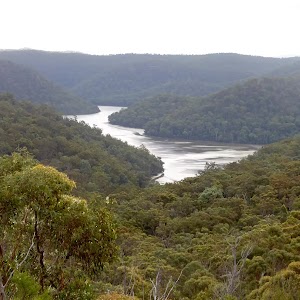
White St firetrail
And Walk
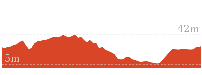
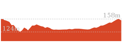
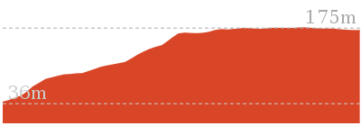
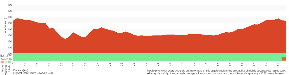
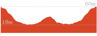
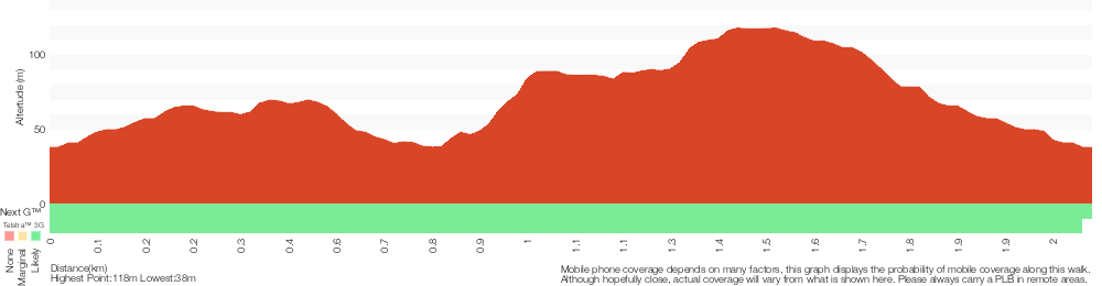
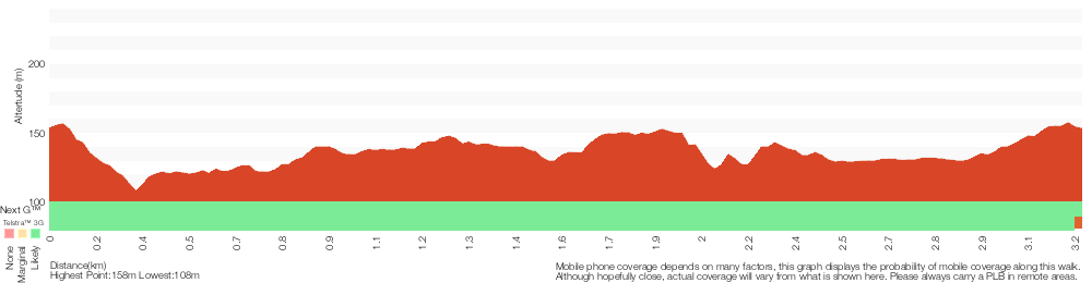
White St firetrail


30 mins

65 m
Moderate track

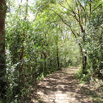

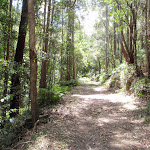


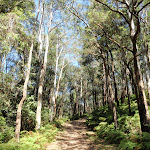

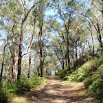


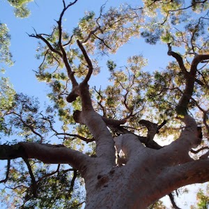
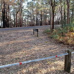
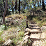
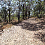
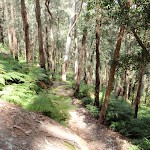
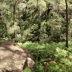
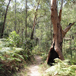
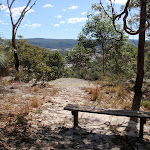
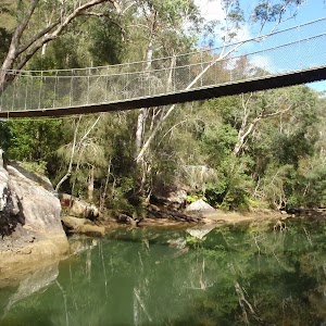
Rumbalara Reserve
Rumbalara Reserve Flora and Fauna
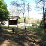
(0km) End of White St → Southern int of White St firetrail and Rainforest walk

530 m
12 mins
31m
-17m
Moderate track
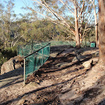
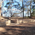
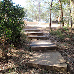
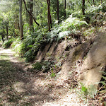
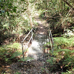
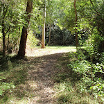
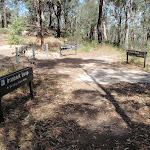
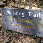
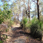
Veer left: From the intersection, this walk follows the management trail gently up the hill, leaving the ‘Cappers Gully’ signpost behind on the right. After a very short distance, the walk arrives at an intersection, signposted ‘Interpretive Centre’, beside a fenced area.
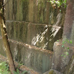
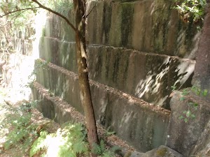
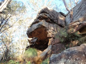
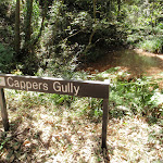
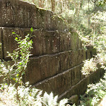
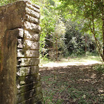
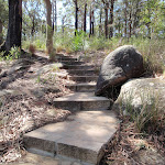
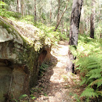
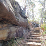
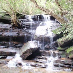
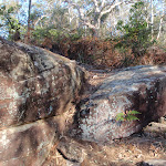
Cappers Gully quarry
(0.53km) Southern int of White St firetrail and Rainforest walk → Car park at int of White St firetrail and John Whiteway Dr
440 m
10 mins
34m
-15m
Moderate track
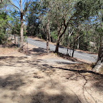
(0.97km) Car park at int of White St firetrail and John Whiteway Dr → Int of White St firetrail and John Whiteway Dr
20 m
0m
-1m
Moderate track
Maps for the White St firetrail walk
You can download the PDF for this walk to print a map.
These maps below cover the walk and the wider area around the walk, they are worth carrying for safety reasons.
| Gosford | 1:25 000 Map Series | 91312S GOSFORD | NSW-91312S |
| Gosford | 1:100 000 Map Series | 9131 GOSFORD | 9131 |
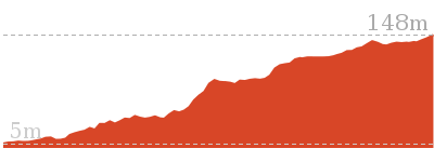
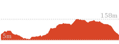
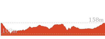
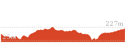
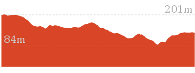
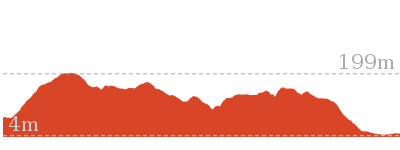
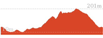
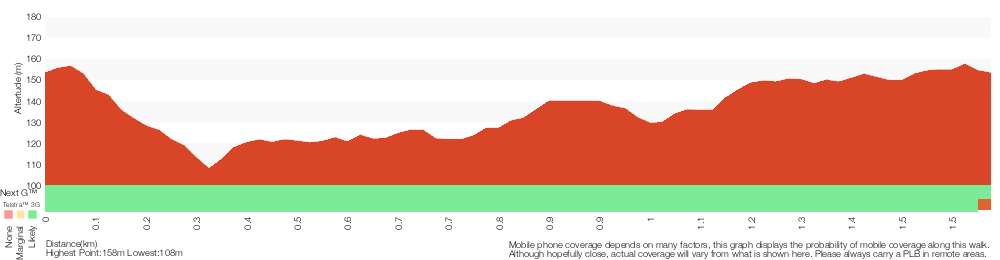
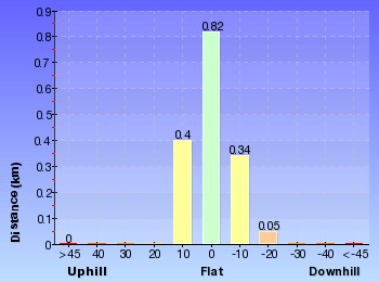
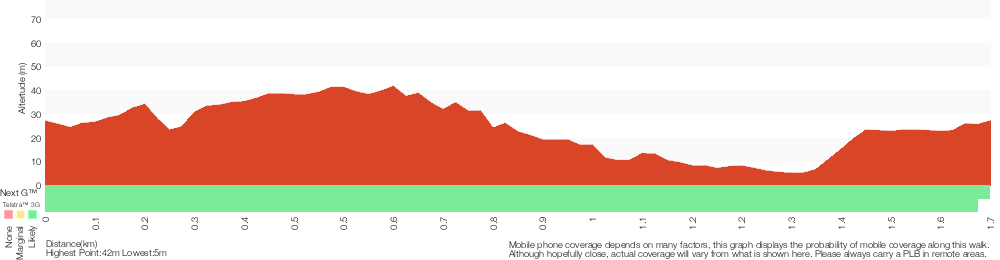
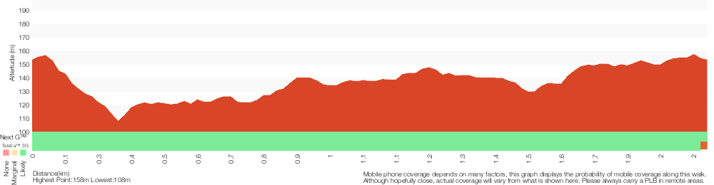
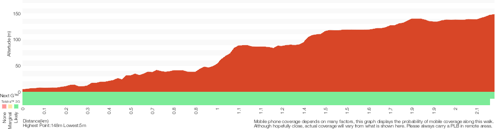
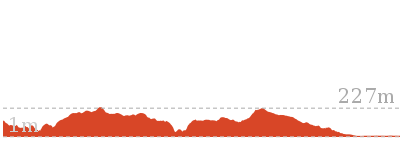
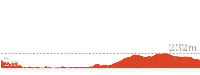
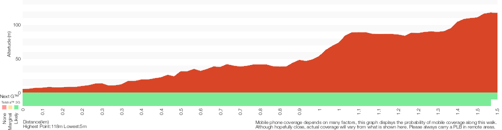
Cross sectional view of the White St firetrail bushwalking track
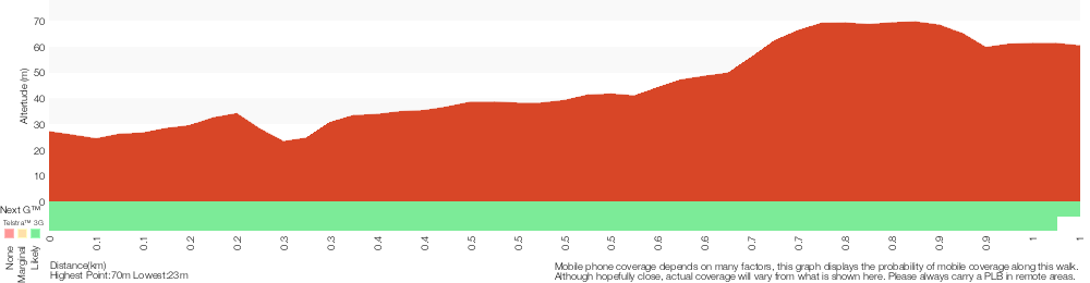
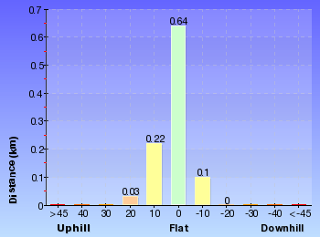
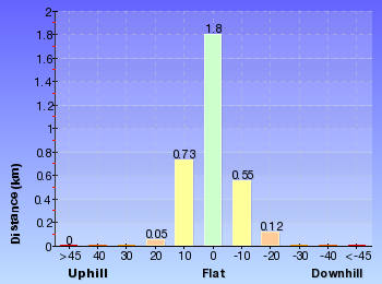
Analysis and summary of the altitude variation on the White St firetrail
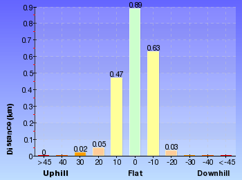
Overview of this walks grade – based on the AS 2156.1 – 2001
Under this standard, a walk is graded based on the most difficult section of the walk.
| Length | 991 m | ||
| Time | 30 mins | ||
| . | |||
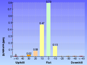
| Grade 3/6 Moderate track |
AS 2156.1 | Gradient | Short steep hills (3/6) |
| Quality of track | Clear and well formed track or trail (2/6) | ||
| Signs | Directional signs along the way (3/6) | ||
| Experience Required | No experience required (1/6) | ||
| Weather | Weather generally has little impact on safety (1/6) | ||
| Infrastructure | Limited facilities, not all cliffs are fenced (3/6) |
Some more details of this walks Grading
Here is a bit more details explaining grading looking at sections of the walk
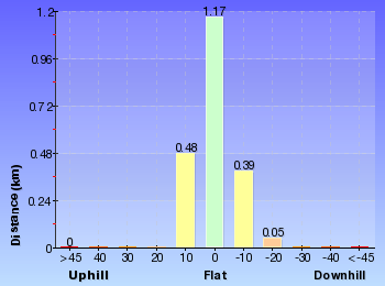
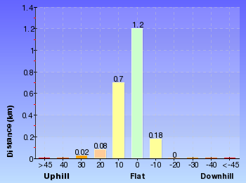
Gradient
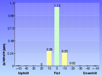
Around 560m of this walk has gentle hills with occasional steps, whilst the remaining 440m has short steep hills.
Quality of track
This whole walk, 990m follows a clear and well formed track or trail.
Signs
This whole walk, 990m has directional signs at most intersection.
Experience Required
This whole walk, 990m requires no previous bushwalking experience.
weather
This whole walk, 990m is not usually affected by severe weather events (that would unexpectedly impact safety and navigation).
Infrastructure
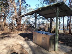
Around 560m of this walk has limited facilities (such as not all cliffs fenced), whilst the remaining 440m is close to useful facilities (such as fenced cliffs and seats).
Similar walks
A list of walks that share part of the track with the White St firetrail walk.
1.7 km Circuit
45 mins
Moderate track
2.1 km Circuit
1 hr 15 mins
Hard track
2.2 km One way
1 Hr
Hard track
3 km One way
1 hr 30 mins
Hard track

3 km Return
1 hr 30 mins
Hard track

6.1 km Circuit
2 hrs 45 mins
Hard track
Other Nearby walks
A list of walks that start near the White St firetrail walk.
643 m Circuit
30 mins
Moderate track
1.4 km Circuit
45 mins
Hard track
1.6 km Circuit
45 mins
Moderate track

2.1 km Circuit
1 Hr
Moderate track
3.3 km Circuit
1 hr 30 mins
Hard track
11.3 km One way
4 hrs 30 mins
Hard track
900 m Return
30 mins
Hard track

1.5 km One way
45 mins
Hard track
24.8 km One way
10 hrs
Hard track
24.8 km One way
2 Days
Hard track

12.3 km One way
5 hrs 30 mins
Hard track
9.5 km One way
4 hrs
Hard track
Plan your trip to and from the walk here
The White St firetrail walk starts at the End of White St (gps: -33.432029, 151.34911)
Your transport options to End of White St are by;
![]() Bus. (get details)
Bus. (get details)
![]() Car. There is free parking available.
Car. There is free parking available.
(get details)
The White St firetrail ends at the Int of White St firetrail and John Whiteway Dr (gps: -33.429712, 151.34681)
Your transport options to Int of White St firetrail and John Whiteway Dr are by;
![]() Bus. (get details)
Bus. (get details)
![]() Car. There is free parking available.
Car. There is free parking available.
(get details)


Short URL = http://wild.tl/wsf
Gallery images
There are other downloads I am still working on.
You will probably need to login to access these — still all free.
* KML (google earth file)
* GPX (GPS file)
Special Maps/ brochures
* A3 topo maps
* PDF with Lands Topo map base
* PDF with arial image (and map overlay)
I wanted to get the main site live first, this extra stuff will come in time.
Happy walking
Matt 🙂
Red Gum Walk
And Walk
Red Gum Walk

45 mins
81 m
Hard track
At the time of writing, some or all of the southern leg of the Red Gum Track was closed. The walk described here returns along the road instead. Despite these changes, this is still a worthwhile walk with some nice scenery along the way. Wannagan Lookout has some great views over North Gosford and surrounds. Note that the entrance gate on Dolly Ave, for the upper section of Rumbalara, is locked at 8pm each evening.


Rumbalara Reserve
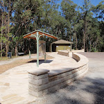
Yaruga Picnic Area
(0km) Yaruga Picnic Area BBQs → Western int of Red Gum walk and Dolly Ave
60 m
1 mins
4m
-3m
Moderate track
(0.06km) Western int of Red Gum walk and Dolly Ave → Int of Flannel Flower walk and Red Gum walk
60 m
1 mins
0m
-5m
Moderate track
Rumbalara Reserve Flora and Fauna
(0.12km) Int of Flannel Flower walk and Red Gum walk → Wannagan Lookout
420 m
12 mins
35m
-51m
Hard track
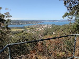
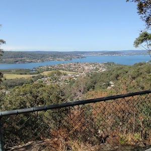
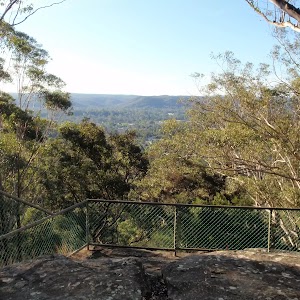
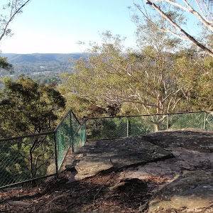
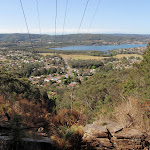
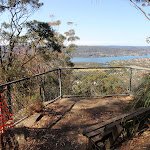
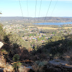
Veer right: From the intersection, this walk follows the track as it goes gently up the hill, immediately bending to the right. The walk meanders through some good scenery for a short distance before reaching the fenced Wannagan Lookout[3], with great views to the north.
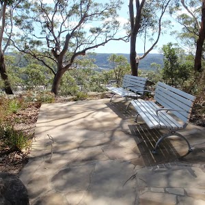
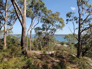
Wannagan Lookout
(0.54km) Wannagan Lookout → Int of Red Gum walk and Mouat Walk
290 m
6 mins
7m
-10m
Hard track
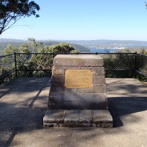
(0.82km) Int of Red Gum walk and Mouat Walk → Sculpture of Edward John Eyre
150 m
2 mins
1m
-2m
Hard track
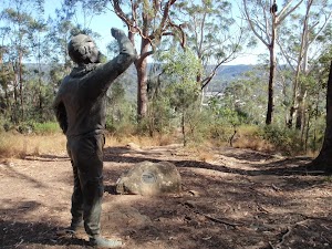
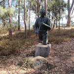
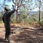
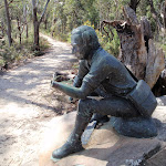
Sculptures in Rumbalara
(0.82km) Int of Red Gum walk and Mouat Walk → Int of Mouat Walk and Dolly Ave
30 m
1 mins
1m
-1m
Moderate track
(0.86km) Int of Mouat Walk and Dolly Ave → Yaruga Picnic Area BBQs
560 m
12 mins
34m
-10m
Moderate track
Continue straight: From the intersection, this walk follows the road gently up the hill towards the sandstone walls of the nearby Yaruga picnic area. The walk climbs the first set of steps on the left, near the ‘Yaruga Picnic Area’ signpost, and goes across the picnic area to the nearby electric BBQs.
Maps for the Red Gum Walk walk
You can download the PDF for this walk to print a map.
These maps below cover the walk and the wider area around the walk, they are worth carrying for safety reasons.
| Gosford | 1:25 000 Map Series | 91312S GOSFORD | NSW-91312S |
| Gosford | 1:100 000 Map Series | 9131 GOSFORD | 9131 |
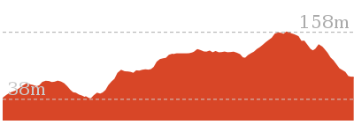
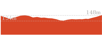
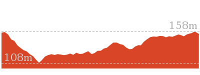
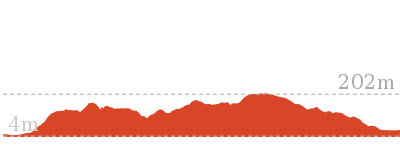
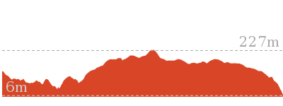
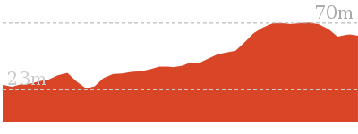
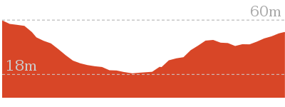
Cross sectional view of the Red Gum Walk bushwalking track
Analysis and summary of the altitude variation on the Red Gum Walk

Overview of this walks grade – based on the AS 2156.1 – 2001
Under this standard, a walk is graded based on the most difficult section of the walk.
| Length | 1.4 km | ||
| Time | 45 mins | ||
| . | |||
| Grade 4/6 Hard track |
AS 2156.1 | Gradient | Short steep hills (3/6) |
| Quality of track | Formed track, with some branches and other obstacles (3/6) | ||
| Signs | Minimal directional signs (4/6) | ||
| Experience Required | Some bushwalking experience recommended (3/6) | ||
| Weather | Weather generally has little impact on safety (1/6) | ||
| Infrastructure | Limited facilities, not all cliffs are fenced (3/6) |
Some more details of this walks Grading
Here is a bit more details explaining grading looking at sections of the walk
Gradient
Around 1km of this walk has gentle hills with occasional steps, whilst the remaining 420m has short steep hills.
Quality of track
Around 760m of this walk follows a formed track, with some branches and other obstacles, whilst the remaining 660m follows a clear and well formed track or trail.
Signs
Around 720m of this walk has directional signs at most intersection, whilst the remaining 700m has minimal directional signs.
Experience Required
Around 720m of this walk requires no previous bushwalking experience, whilst the remaining 700m requires some bushwalking experience.
weather
This whole walk, 1.4km is not usually affected by severe weather events (that would unexpectedly impact safety and navigation).
Infrastructure
Around 1.3km of this walk has limited facilities (such as not all cliffs fenced), whilst the remaining 120m is close to useful facilities (such as fenced cliffs and seats).
Similar walks
A list of walks that share part of the track with the Red Gum Walk walk.
900 m Return
30 mins
Hard track
1.6 km Circuit
45 mins
Moderate track
2.1 km Circuit
1 Hr
Moderate track
3 km One way
1 hr 30 mins
Hard track
3.3 km Circuit
1 hr 30 mins
Hard track
4.1 km One way
2 hrs
Hard track
6.1 km Circuit
2 hrs 45 mins
Hard track
8.5 km One way
3 hrs 45 mins
Hard track
11.3 km One way
4 hrs 30 mins
Hard track
Other Nearby walks
A list of walks that start near the Red Gum Walk walk.
643 m Circuit
30 mins
Moderate track
2.1 km Circuit
1 hr 15 mins
Hard track
991 m One way
30 mins
Moderate track
1.7 km Circuit
45 mins
Moderate track
3 km Return
1 hr 30 mins
Hard track
2.2 km One way
1 Hr
Hard track
5.3 km Circuit
2 hrs 45 mins
Moderate track

2 km Return
1 Hr
Moderate track
890 m Return
30 mins
Easy track
1.6 km Circuit
45 mins
Easy track
1.2 km Circuit
45 mins
Moderate track
1.5 km One way
45 mins
Moderate track

Plan your trip to and from the walk here
The Red Gum Walk walk starts and ends at the Yaruga Picnic Area BBQs (gps: -33.425486, 151.35526)
Your main transport option to Yaruga Picnic Area BBQs is by;
![]() Car. There is free parking available.
Car. There is free parking available.
(get details)
Short URL = http://wild.tl/rgw
Gallery images
There are other downloads I am still working on.
You will probably need to login to access these — still all free.
* KML (google earth file)
* GPX (GPS file)
Special Maps/ brochures
* A3 topo maps
* PDF with Lands Topo map base
* PDF with arial image (and map overlay)
I wanted to get the main site live first, this extra stuff will come in time.
Happy walking
Matt 🙂
Flannel Flower Track
And Walk
Flannel Flower Track

45 mins
88 m
Moderate track
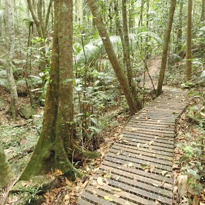
A great walk with some spectacular views and nice forest scenery in the Rumbalara Reserve, near Gosford. The tracks are well formed and signposted, and there are plenty of facilities in the reserve, including free electric BBQs. This walk is very accessible from Gosford and a great way to enjoy some of the wonderful scenery and views of the area. Note that the entrance gate on Dolly Ave, for the upper section of Rumbalara, is locked at 8pm each evening.


Rumbalara Reserve
Yaruga Picnic Area
(0km) Yaruga Picnic Area BBQs → Flannel Flower walk signpost
720 m
17 mins
30m
-57m
Moderate track
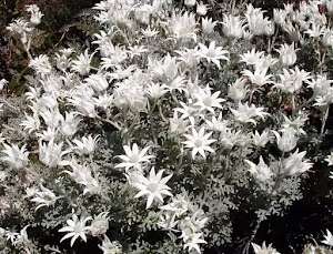
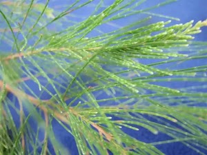
Flannel Flower
(0.72km) Flannel Flower walk signpost → Int of Casuarina walk and Flannel Flower walk
30 m
1 mins
0m
-4m
Moderate track
(0.75km) Int of Casuarina walk and Flannel Flower walk → Junction of Ironbark, Casuarina and Flannel flower walks
180 m
5 mins
21m
-3m
Moderate track
Rumbalara Reserve Flora and Fauna
(0.93km) Junction of Ironbark, Casuarina and Flannel flower walks → Western int of Flannel Flower walk and Dolly Ave
30 m
0m
-1m
Moderate track
(0.95km) Western int of Flannel Flower walk and Dolly Ave → Int of Flannel Flower walk and Red Gum walk
540 m
12 mins
29m
-20m
Moderate track
Veer right: From the intersection, this walk follows the management trail up the hill, keeping the nearby power lines to the right. After a short distance, the walk passes a management trail (to the right) and continues, passing some sort of underground pipe access point, on the left. After a while, the trail reaches an intersection with tracks to the left and right.
(1.49km) Int of Flannel Flower walk and Red Gum walk → Western int of Red Gum walk and Dolly Ave
60 m
1 mins
5m
0m
Moderate track
(1.55km) Western int of Red Gum walk and Dolly Ave → Yaruga Picnic Area BBQs
60 m
1 mins
3m
-4m
Moderate track
Maps for the Flannel Flower Track walk
You can download the PDF for this walk to print a map.
These maps below cover the walk and the wider area around the walk, they are worth carrying for safety reasons.
| Gosford | 1:25 000 Map Series | 91312S GOSFORD | NSW-91312S |
| Gosford | 1:100 000 Map Series | 9131 GOSFORD | 9131 |
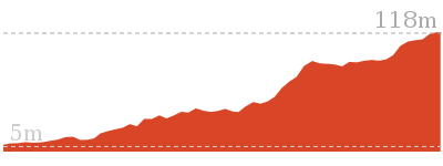
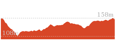
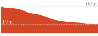
Cross sectional view of the Flannel Flower Track bushwalking track
Analysis and summary of the altitude variation on the Flannel Flower Track
Overview of this walks grade – based on the AS 2156.1 – 2001
Under this standard, a walk is graded based on the most difficult section of the walk.
| Length | 1.6 km | ||
| Time | 45 mins | ||
| . | |||
| Grade 3/6 Moderate track |
AS 2156.1 | Gradient | Short steep hills (3/6) |
| Quality of track | Formed track, with some branches and other obstacles (3/6) | ||
| Signs | Directional signs along the way (3/6) | ||
| Experience Required | Some bushwalking experience recommended (3/6) | ||
| Weather | Weather generally has little impact on safety (1/6) | ||
| Infrastructure | Limited facilities, not all cliffs are fenced (3/6) |
Some more details of this walks Grading
Here is a bit more details explaining grading looking at sections of the walk
Gradient
Around 940m of this walk has short steep hills, whilst the remaining 670m has gentle hills with occasional steps.
Quality of track
Around 1.2km of this walk follows a formed track, with some branches and other obstacles, whilst the remaining 450m follows a clear and well formed track or trail.
Signs
Around 890m of this walk has directional signs at most intersection, whilst the remaining 720m is clearly signposted.
Experience Required
Around 1.3km of this walk requires some bushwalking experience, whilst the remaining 320m requires no previous bushwalking experience.
weather
This whole walk, 1.6km is not usually affected by severe weather events (that would unexpectedly impact safety and navigation).
Infrastructure
Around 830m of this walk has limited facilities (such as not all cliffs fenced), whilst the remaining 780m is close to useful facilities (such as fenced cliffs and seats).
Similar walks
A list of walks that share part of the track with the Flannel Flower Track walk.
1.4 km Circuit
45 mins
Hard track
2.1 km Circuit
1 Hr
Moderate track
2.2 km One way
1 Hr
Hard track
3 km One way
1 hr 30 mins
Hard track
3.3 km Circuit
1 hr 30 mins
Hard track
6.1 km Circuit
2 hrs 45 mins
Hard track
8.5 km One way
3 hrs 45 mins
Hard track
11.3 km One way
4 hrs 30 mins
Hard track
Other Nearby walks
A list of walks that start near the Flannel Flower Track walk.
900 m Return
30 mins
Hard track
643 m Circuit
30 mins
Moderate track
2.1 km Circuit
1 hr 15 mins
Hard track
991 m One way
30 mins
Moderate track
1.7 km Circuit
45 mins
Moderate track
3 km Return
1 hr 30 mins
Hard track
5.3 km Circuit
2 hrs 45 mins
Moderate track
2 km Return
1 Hr
Moderate track
890 m Return
30 mins
Easy track
1.6 km Circuit
45 mins
Easy track
1.2 km Circuit
45 mins
Moderate track
1.5 km One way
45 mins
Moderate track
Plan your trip to and from the walk here
The Flannel Flower Track walk starts and ends at the Yaruga Picnic Area BBQs (gps: -33.425486, 151.35526)
Your main transport option to Yaruga Picnic Area BBQs is by;
![]() Car. There is free parking available.
Car. There is free parking available.
(get details)
Short URL = http://wild.tl/fft
Gallery images
There are other downloads I am still working on.
You will probably need to login to access these — still all free.
* KML (google earth file)
* GPX (GPS file)
Special Maps/ brochures
* A3 topo maps
* PDF with Lands Topo map base
* PDF with arial image (and map overlay)
I wanted to get the main site live first, this extra stuff will come in time.
Happy walking
Matt 🙂
White St Rainforest loop
And Walk
White St Rainforest loop

45 mins
76 m
Moderate track
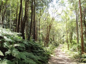
A very nice loop walk in the lower part of the Rumbalara Reserve, Gosford. The walk includes a section of road but spends most time in very nice forest scenery, including pockets of the beautiful rainforest in the reserve. This walk has substantially fewer steps than some of the other walks in the reserve and is a great way to see some of the beautiful scenery in Rumbalara.


(0km) End of White St → Northern int of White St firetrail and Rainforest walk
490 m
11 mins
27m
-16m
Moderate track
Rumbalara Reserve Flora and Fauna
(0.49km) Northern int of White St firetrail and Rainforest walk → Southern int of White St firetrail and Rainforest walk
50 m
1 mins
4m
-1m
Moderate track
Cappers Gully quarry
(0.53km) Southern int of White St firetrail and Rainforest walk → Top of staircase on Rainforest walk
400 m
9 mins
15m
-37m
Moderate track
(0.94km) Top of staircase on Rainforest walk → Back gate of 2GO car park
220 m
5 mins
4m
-16m
Moderate track
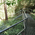
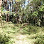
Continue straight: From the bottom of the metal staircase, this walk follows the management trail away from the stairs. The trail soon bends to the right and continues for a short distance before passing a plaque marking the handing over of Cappers Gully Reserve, set in a stone, to the left. The trail continues a little further to an intersection just before the gate at the back of the 2GO radio station car park. The intersection is marked with a pair of track arrows on a wooden post.
(1.16km) Back gate of 2GO car park → Henry Parry Dr trackhead
160 m
3 mins
1m
-4m
Moderate track
(1.32km) Henry Parry Dr trackhead → End of White St
370 m
8 mins
25m
-3m
Moderate track
Maps for the White St Rainforest loop walk
You can download the PDF for this walk to print a map.
These maps below cover the walk and the wider area around the walk, they are worth carrying for safety reasons.
| Gosford | 1:25 000 Map Series | 91312S GOSFORD | NSW-91312S |
| Gosford | 1:100 000 Map Series | 9131 GOSFORD | 9131 |
Cross sectional view of the White St Rainforest loop bushwalking track
Analysis and summary of the altitude variation on the White St Rainforest loop
Overview of this walks grade – based on the AS 2156.1 – 2001
Under this standard, a walk is graded based on the most difficult section of the walk.
| Length | 1.7 km | ||
| Time | 45 mins | ||
| . | |||
| Grade 3/6 Moderate track |
AS 2156.1 | Gradient | Short steep hills (3/6) |
| Quality of track | Formed track, with some branches and other obstacles (3/6) | ||
| Signs | Directional signs along the way (3/6) | ||
| Experience Required | Some bushwalking experience recommended (3/6) | ||
| Weather | Storms may impact on navigation and safety (3/6) | ||
| Infrastructure | Limited facilities, not all cliffs are fenced (3/6) |
Some more details of this walks Grading
Here is a bit more details explaining grading looking at sections of the walk
Gradient
Around 890m of this walk has gentle hills with occasional steps, whilst the remaining 790m has short steep hills.
Quality of track
Around 1.1km of this walk follows a clear and well formed track or trail, whilst the remaining 590m follows a formed track, with some branches and other obstacles.
Signs
Around 1.2km of this walk has directional signs at most intersection, whilst the remaining 530m is clearly signposted.
Experience Required
Around 1.1km of this walk requires no previous bushwalking experience, whilst the remaining 560m requires some bushwalking experience.
weather
Around 1.5km of this walk is not usually affected by severe weather events (that would unexpectedly impact safety and navigation), whilst the remaining 160m is affected by storms that may impact your navigation and safety.
Infrastructure
Around 1.1km of this walk has limited facilities (such as not all cliffs fenced), whilst the remaining 590m is close to useful facilities (such as fenced cliffs and seats).
Similar walks
A list of walks that share part of the track with the White St Rainforest loop walk.
991 m One way
30 mins
Moderate track
2.1 km Circuit
1 hr 15 mins
Hard track
2.2 km One way
1 Hr
Hard track
3 km One way
1 hr 30 mins
Hard track
3 km Return
1 hr 30 mins
Hard track
6.1 km Circuit
2 hrs 45 mins
Hard track
Other Nearby walks
A list of walks that start near the White St Rainforest loop walk.
643 m Circuit
30 mins
Moderate track
1.4 km Circuit
45 mins
Hard track
1.6 km Circuit
45 mins
Moderate track
2.1 km Circuit
1 Hr
Moderate track
3.3 km Circuit
1 hr 30 mins
Hard track
11.3 km One way
4 hrs 30 mins
Hard track
900 m Return
30 mins
Hard track
1.5 km One way
45 mins
Hard track
24.8 km One way
10 hrs
Hard track
24.8 km One way
2 Days
Hard track
12.3 km One way
5 hrs 30 mins
Hard track
9.5 km One way
4 hrs
Hard track
Plan your trip to and from the walk here
The White St Rainforest loop walk starts and ends at the End of White St (gps: -33.432029, 151.34911)
Your transport options to End of White St are by;
![]() Bus. (get details)
Bus. (get details)
![]() Car. There is free parking available.
Car. There is free parking available.
(get details)
Short URL = http://wild.tl/wsrl
Gallery images
There are other downloads I am still working on.
You will probably need to login to access these — still all free.
* KML (google earth file)
* GPX (GPS file)
Special Maps/ brochures
* A3 topo maps
* PDF with Lands Topo map base
* PDF with arial image (and map overlay)
I wanted to get the main site live first, this extra stuff will come in time.
Happy walking
Matt 🙂
Ironbark and Flannel Flower circuit
And Walk
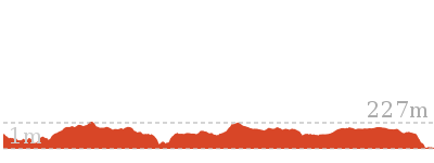
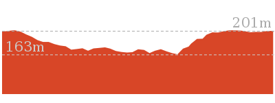
Ironbark and Flannel Flower circuit

1 Hr
107 m
Moderate track
A great circuit walk, covering two of the popular walking tracks and some of the great sights in the upper section of the Rumbalara Reserve. You will enjoy some really nice forest walking and fantastic views across various parts of Gosford and the surrounding areas. Note that the entrance gate on Dolly Ave, for the upper section of Rumbalara, is locked at 8pm each evening.

Rumbalara Reserve
Yaruga Picnic Area
(0km) Yaruga Picnic Area BBQs → Flannel Flower walk signpost
720 m
17 mins
30m
-57m
Moderate track
Flannel Flower
(0.72km) Flannel Flower walk signpost → Int of Casuarina walk and Flannel Flower walk
30 m
1 mins
0m
-4m
Moderate track
(0.75km) Int of Casuarina walk and Flannel Flower walk → Junction of Ironbark, Casuarina and Flannel flower walks
180 m
5 mins
21m
-3m
Moderate track
Rumbalara Reserve Flora and Fauna
(0.93km) Junction of Ironbark, Casuarina and Flannel flower walks → Matthew Flinders sculpture
180 m
4 mins
7m
-10m
Moderate track
Continue straight: From the intersection, this walk follows the ‘Nurrunga Picnic Area’ arrow (Ironbark Loop sign), along the bush track, keeping the views of Gosford to the left. After a short distance, the walk arrives at an intersection, with an ‘Ironbark Loop’ signpost pointing back ‘To Casuarina Track’, beside a sculpture of Matthew Flinders.
(1.11km) Matthew Flinders sculpture → Sir Charles Kingsford Smith sculpture
40 m
1 mins
1m
0m
Moderate track
Sculptures in Rumbalara
(1.15km) Sir Charles Kingsford Smith sculpture → Western int of Flannel Flower walk and Dolly Ave
280 m
5 mins
11m
-11m
Moderate track
Continue straight: From this ‘Ironbark Loop’ sign, this walk follows the ‘To Casuarina Track’ arrow along the management trail, initially keeping the picnic area to the right. The walk continues, passing a toilet block, to the right, then arrives at a sign, beside the road, pointing back to ‘Nurrunga Picnic Area’.
Continue straight: From the ‘Ironbark Loop’ sign, the walk immediately crosses the road and follows the bush track a little to a track junction with signposts for the ‘Ironbark Loop’, the ‘Casuarina Track’ and the ‘Flannel Flower Track’
Turn left: From the intersection, this walk follows the ‘Loop to Yaruga Picnic Area’ arrow between the metal posts and across the edge of the small car park. The walk immediately crosses the road to an intersection with a track, with a ‘Flannel Flower Track’ signpost pointing back to ‘Yaruga Picnic Area’.
(1.43km) Western int of Flannel Flower walk and Dolly Ave → Int of Flannel Flower walk and Red Gum walk
540 m
12 mins
29m
-20m
Moderate track
Veer right: From the intersection, this walk follows the management trail up the hill, keeping the nearby power lines to the right. After a short distance, the walk passes a management trail (to the right) and continues, passing some sort of underground pipe access point, on the left. After a while, the trail reaches an intersection with tracks to the left and right.
(1.96km) Int of Flannel Flower walk and Red Gum walk → Yaruga Picnic Area BBQs
120 m
2 mins
8m
-4m
Moderate track
Continue straight: From the intersection, this walk follows the road gently up the hill towards the sandstone walls of the nearby Yaruga picnic area. The walk climbs the first set of steps on the left, near the ‘Yaruga Picnic Area’ signpost, and goes across the picnic area to the nearby electric BBQs.
Maps for the Ironbark and Flannel Flower circuit walk
You can download the PDF for this walk to print a map.
These maps below cover the walk and the wider area around the walk, they are worth carrying for safety reasons.
| Gosford | 1:25 000 Map Series | 91312S GOSFORD | NSW-91312S |
| Gosford | 1:100 000 Map Series | 9131 GOSFORD | 9131 |
Cross sectional view of the Ironbark and Flannel Flower circuit bushwalking track
Analysis and summary of the altitude variation on the Ironbark and Flannel Flower circuit
Overview of this walks grade – based on the AS 2156.1 – 2001
Under this standard, a walk is graded based on the most difficult section of the walk.
| Length | 2.1 km | ||
| Time | 1 Hr | ||
| . | |||
| Grade 3/6 Moderate track |
AS 2156.1 | Gradient | Short steep hills (3/6) |
| Quality of track | Formed track, with some branches and other obstacles (3/6) | ||
| Signs | Directional signs along the way (3/6) | ||
| Experience Required | Some bushwalking experience recommended (3/6) | ||
| Weather | Weather generally has little impact on safety (1/6) | ||
| Infrastructure | Limited facilities, not all cliffs are fenced (3/6) |
Some more details of this walks Grading
Here is a bit more details explaining grading looking at sections of the walk
Gradient
1.1km of this walk has gentle hills with occasional steps and another 940m has short steep hills. The remaining (70m) is flat with no steps.
Quality of track
Around 1.3km of this walk follows a formed track, with some branches and other obstacles, whilst the remaining 820m follows a clear and well formed track or trail.
Signs
Around 1.4km of this walk has directional signs at most intersection, whilst the remaining 720m is clearly signposted.
Experience Required
Around 1.3km of this walk requires some bushwalking experience, whilst the remaining 800m requires no previous bushwalking experience.
weather
This whole walk, 2.1km is not usually affected by severe weather events (that would unexpectedly impact safety and navigation).
Infrastructure
Around 1.1km of this walk is close to useful facilities (such as fenced cliffs and seats), whilst the remaining 990m has limited facilities (such as not all cliffs fenced).
Similar walks
A list of walks that share part of the track with the Ironbark and Flannel Flower circuit walk.
643 m Circuit
30 mins
Moderate track
1.4 km Circuit
45 mins
Hard track
1.6 km Circuit
45 mins
Moderate track
2.2 km One way
1 Hr
Hard track
3 km One way
1 hr 30 mins
Hard track
3.3 km Circuit
1 hr 30 mins
Hard track
6.1 km Circuit
2 hrs 45 mins
Hard track
8.5 km One way
3 hrs 45 mins
Hard track
11.3 km One way
4 hrs 30 mins
Hard track
Other Nearby walks
A list of walks that start near the Ironbark and Flannel Flower circuit walk.
900 m Return
30 mins
Hard track
2.1 km Circuit
1 hr 15 mins
Hard track
991 m One way
30 mins
Moderate track
1.7 km Circuit
45 mins
Moderate track
3 km Return
1 hr 30 mins
Hard track
5.3 km Circuit
2 hrs 45 mins
Moderate track
2 km Return
1 Hr
Moderate track
890 m Return
30 mins
Easy track
1.6 km Circuit
45 mins
Easy track
1.2 km Circuit
45 mins
Moderate track
1.5 km One way
45 mins
Moderate track
4.1 km One way
2 hrs
Hard track
Plan your trip to and from the walk here
The Ironbark and Flannel Flower circuit walk starts and ends at the Yaruga Picnic Area BBQs (gps: -33.425486, 151.35526)
Your main transport option to Yaruga Picnic Area BBQs is by;
![]() Car. There is free parking available.
Car. There is free parking available.
(get details)
Short URL = http://wild.tl/iaffc
Gallery images
There are other downloads I am still working on.
You will probably need to login to access these — still all free.
* KML (google earth file)
* GPX (GPS file)
Special Maps/ brochures
* A3 topo maps
* PDF with Lands Topo map base
* PDF with arial image (and map overlay)
I wanted to get the main site live first, this extra stuff will come in time.
Happy walking
Matt 🙂
Ouraka Point loop
And Walk
Ouraka Point loop

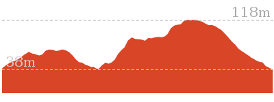
1 hr 15 mins
141 m
Hard track
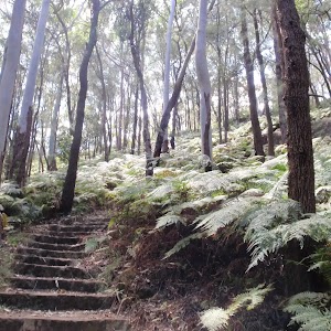
A beautiful walk, taking in some of the scenic highlights of the lower section of the Rumbalara Reserve. The walk covers a great variety of vegetation, from quite dry eucalypt forest through to rainforest. The tracks are well formed, with a lot of steps in the steeper sections, making the walking a little easier. This is a great walk to see some of the excellent scenery in Rumbalara. A very short, optional sidetrip takes you to a sculpture of Charles Sturt, adding some more variety to the walk. The easy access from Gosford train station also makes it a great walk for those using public transport.


(0km) Rumbalara Environmental Education Centre car park → Rumbalara Environmental Education Centre trackhead
40 m
1 mins
3m
0m
Easy track
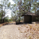
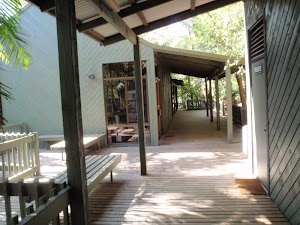
Rumbalara Environmental Education Centre
(0.04km) Rumbalara Environmental Education Centre trackhead → Int of Casuarina track and JWD link trail
140 m
4 mins
18m
-1m
Moderate track
Turn right: From the intersection, this walk follows the management trail gently up the hill, leaving the bush track steps behind to the right. The trail goes gently up the hill for a short distance to an intersection at the bottom of a metal staircase, signposted ‘Casuarina Track’.
(0.17km) Int of Casuarina track and JWD link trail → Int of Casuarina track and Casuarina link trail
60 m
2 mins
8m
0m
Moderate track
(0.23km) Int of Casuarina track and Casuarina link trail → Car park at int of White St firetrail and John Whiteway Dr
60 m
1 mins
0m
-4m
Easy track
(0.29km) Car park at int of White St firetrail and John Whiteway Dr → Southern int of White St firetrail and Rainforest walk
440 m
10 mins
15m
-34m
Moderate track
Cappers Gully quarry
(0.72km) Southern int of White St firetrail and Rainforest walk → Southern Int of Rainforest walk and Bayview firetrail
300 m
10 mins
54m
-7m
Hard track
Veer left: From the intersection, this walk follows the ‘Ouraka Point’ arrow up the steps and along the bush track. The walk crosses some short metal footbridges and then climbs more steeply, through beautiful forest scenery. The walk climbs a lot of sandstone steps and some sets of metal stairs, and after some time arrives at an intersection, with a ‘Rainforest Track’ signpost pointing back to ‘Cappers Gully’.
(1.02km) Southern Int of Rainforest walk and Bayview firetrail → Int of Rainforest walk and Casuarina walk
440 m
11 mins
41m
-13m
Hard track
Turn left: From the intersection, this walk follows the ‘Ouraka Point’ arrow down the steps and along the bush track. After descending for a short distance, the track bends to the right and levels out. The track meanders for some time through beautiful forest scenery, crossing two short metal footbridges, before climbing a long set of sandstone steps, then a metal staircase, arriving at an intersection with a management trail, with a ‘Rainforest Track’ signpost pointing back to ‘Cappers Gully’.
Casuarina
(1.46km) Int of Rainforest walk and Casuarina walk → Sculpture of Charles Sturt
30 m
1 mins
2m
0m
Moderate track
Sculptures in Rumbalara
(1.46km) Int of Rainforest walk and Casuarina walk → Ouraka Point
220 m
4 mins
1m
-13m
Moderate track
Ouraka Point
(1.68km) Ouraka Point → Rumbalara Environmental Education Centre car park
420 m
12 mins
1m
-68m
Moderate track
Continue straight: From the intersection, this walk follows the management trail gently down the hill, leaving the steps behind on the right. After a short distance, the walk arrives at an intersection marked by an information board, and a ‘Casuarina Track’ signpost pointing back to the ‘Picnic Areas’.
Turn right: From the intersection, the walk follows the ‘Field Studies Centre’ arrow down the steps. After a short distance, the walk goes down a metal staircase, arriving at an intersection with a management trail, and a ‘Casuarina Track’ signpost pointing back to the ‘Picnic Areas’.
Turn right: From the intersection, this walk follows the management trail gently down the hill, leaving the metal staircase behind on the right. The trail goes gently down the hill for a short distance to an unmarked intersection with a bush track (going down some wooden steps to the left).
Turn left: From the intersection, this walk follows the track down the steps and immediately bends to the right. After descending a little, the track bends to the left and crosses a small bridge, then goes down some more steps to the trackhead at the back of the Rumbalara EEC buildings, with a ‘Walking Trail’ arrow pointing back the way you came.
Turn right: From the trackhead, this walk goes across the timber deck and down the paved footpath to the nearby car park.
Maps for the Ouraka Point loop walk
You can download the PDF for this walk to print a map.
These maps below cover the walk and the wider area around the walk, they are worth carrying for safety reasons.
| Gosford | 1:25 000 Map Series | 91312S GOSFORD | NSW-91312S |
| Gosford | 1:100 000 Map Series | 9131 GOSFORD | 9131 |
Cross sectional view of the Ouraka Point loop bushwalking track
Analysis and summary of the altitude variation on the Ouraka Point loop
Overview of this walks grade – based on the AS 2156.1 – 2001
Under this standard, a walk is graded based on the most difficult section of the walk.
| Length | 2.1 km | ||
| Time | 1 hr 15 mins | ||
| . | |||
| Grade 4/6 Hard track |
AS 2156.1 | Gradient | Very steep (4/6) |
| Quality of track | Formed track, with some branches and other obstacles (3/6) | ||
| Signs | Directional signs along the way (3/6) | ||
| Experience Required | Some bushwalking experience recommended (3/6) | ||
| Weather | Weather generally has little impact on safety (1/6) | ||
| Infrastructure | Limited facilities, not all cliffs are fenced (3/6) |
Some more details of this walks Grading
Here is a bit more details explaining grading looking at sections of the walk
Gradient
810m of this walk has short steep hills and another 640m is very steep. Whilst another 600m has gentle hills with occasional steps and the remaining 50m is flat with no steps.
Quality of track
1.4km of this walk follows a clear and well formed track or trail and another 640m follows a formed track, with some branches and other obstacles. The remaining (80m) follows a smooth and hardened path.
Signs
Around 1.7km of this walk has directional signs at most intersection, whilst the remaining 450m is clearly signposted.
Experience Required
Around 1.8km of this walk requires no previous bushwalking experience, whilst the remaining 250m requires some bushwalking experience.
weather
This whole walk, 2.1km is not usually affected by severe weather events (that would unexpectedly impact safety and navigation).
Infrastructure
Around 1.4km of this walk is close to useful facilities (such as fenced cliffs and seats), whilst the remaining 680m has limited facilities (such as not all cliffs fenced).
Similar walks
A list of walks that share part of the track with the Ouraka Point loop walk.
991 m One way
30 mins
Moderate track
1.7 km Circuit
45 mins
Moderate track
2.2 km One way
1 Hr
Hard track
3 km One way
1 hr 30 mins
Hard track
3 km Return
1 hr 30 mins
Hard track
6.1 km Circuit
2 hrs 45 mins
Hard track
8.5 km One way
3 hrs 45 mins
Hard track
11.3 km One way
4 hrs 30 mins
Hard track
Other Nearby walks
A list of walks that start near the Ouraka Point loop walk.
643 m Circuit
30 mins
Moderate track
1.4 km Circuit
45 mins
Hard track
1.6 km Circuit
45 mins
Moderate track
2.1 km Circuit
1 Hr
Moderate track
3.3 km Circuit
1 hr 30 mins
Hard track
900 m Return
30 mins
Hard track
5.3 km Circuit
2 hrs 45 mins
Moderate track
2 km Return
1 Hr
Moderate track
890 m Return
30 mins
Easy track
1.6 km Circuit
45 mins
Easy track
24.8 km One way
10 hrs
Hard track
24.8 km One way
2 Days
Hard track
Plan your trip to and from the walk here
The Ouraka Point loop walk starts and ends at the Rumbalara Environmental Education Centre car park (gps: -33.427727, 151.34768)
Your transport options to Rumbalara Environmental Education Centre car park are by;
![]() Bus. (get details)
Bus. (get details)
![]() Car. There is free parking available.
Car. There is free parking available.
(get details)
Short URL = http://wild.tl/opl
Gallery images
There are other downloads I am still working on.
You will probably need to login to access these — still all free.
* KML (google earth file)
* GPX (GPS file)
Special Maps/ brochures
* A3 topo maps
* PDF with Lands Topo map base
* PDF with arial image (and map overlay)
I wanted to get the main site live first, this extra stuff will come in time.
Happy walking
Matt 🙂
Rainforest walk to Nurrunga picnic area

1 Hr
196 m
Hard track
An extended version of the Rumbalara Reserve Rainforest Walk. After walking through some beautiful pockets of rainforest, this walk continues to the upper section of the reserve, enjoying some great views across Gosford and the surrounding areas. The sheer variety in the vegetation from the start of this walk to the end makes it even more interesting. Parts of the track are quite steep, although the well-formed track with plenty of steps makes the walking easier. This walk also takes you past three of the four Rumbalara bronze sculptures. Plenty of variety and a beautiful walk. Note that the entrance gate on Dolly Ave, for the upper section of Rumbalara, is locked at 8pm each evening.


Rumbalara Reserve
(0km) Henry Parry Dr trackhead → Back gate of 2GO car park
160 m
3 mins
4m
-1m
Moderate track
(0.16km) Back gate of 2GO car park → Top of staircase on Rainforest walk
220 m
5 mins
16m
-4m
Moderate track
Continue straight: From the end of the management trail, this walk goes up the metal staircase, arriving at an intersection, with a ‘Rainforest Track’ signpost, at the top of the stairs, pointing back to ‘Henry Parry Drive’.
Rumbalara Reserve Flora and Fauna
(0.38km) Top of staircase on Rainforest walk → Southern int of White St firetrail and Rainforest walk
400 m
9 mins
37m
-15m
Moderate track
Cappers Gully quarry
(0.78km) Southern int of White St firetrail and Rainforest walk → Southern Int of Rainforest walk and Bayview firetrail
300 m
10 mins
54m
-7m
Hard track
Veer left: From the intersection, this walk follows the ‘Ouraka Point’ arrow up the steps and along the bush track. The walk crosses some short metal footbridges and then climbs more steeply, through beautiful forest scenery. The walk climbs a lot of sandstone steps and some sets of metal stairs, and after some time arrives at an intersection, with a ‘Rainforest Track’ signpost pointing back to ‘Cappers Gully’.
(1.08km) Southern Int of Rainforest walk and Bayview firetrail → Int of Rainforest walk and Casuarina walk
440 m
11 mins
41m
-13m
Hard track
Turn left: From the intersection, this walk follows the ‘Ouraka Point’ arrow down the steps and along the bush track. After descending for a short distance, the track bends to the right and levels out. The track meanders for some time through beautiful forest scenery, crossing two short metal footbridges, before climbing a long set of sandstone steps, then a metal staircase, arriving at an intersection with a management trail, with a ‘Rainforest Track’ signpost pointing back to ‘Cappers Gully’.
Casuarina
(1.52km) Int of Rainforest walk and Casuarina walk → Ouraka Point
220 m
4 mins
1m
-13m
Moderate track
Ouraka Point
(1.52km) Int of Rainforest walk and Casuarina walk → Sculpture of Charles Sturt
30 m
1 mins
2m
0m
Moderate track
(1.55km) Sculpture of Charles Sturt → Junction of Ironbark, Casuarina and Flannel flower walks
320 m
7 mins
24m
-3m
Moderate track
Veer left: From the intersection, this walk follows the ‘Nurrunga Picnic Area’ arrow along the paved track, keeping the views of Gosford to the left. The walk climbs gently for a short distance before arriving at a track junction with signposts for the ‘Ironbark Loop’, the ‘Casuarina Track’ and the ‘Flannel Flower Track’.
(1.87km) Junction of Ironbark, Casuarina and Flannel flower walks → Matthew Flinders sculpture
180 m
4 mins
7m
-10m
Moderate track
Continue straight: From the intersection, this walk follows the ‘Nurrunga Picnic Area’ arrow (Ironbark Loop sign), along the bush track, keeping the views of Gosford to the left. After a short distance, the walk arrives at an intersection, with an ‘Ironbark Loop’ signpost pointing back ‘To Casuarina Track’, beside a sculpture of Matthew Flinders.
Sculptures in Rumbalara
(2.06km) Matthew Flinders sculpture → Sir Charles Kingsford Smith sculpture
40 m
1 mins
1m
0m
Moderate track
(2.09km) Sir Charles Kingsford Smith sculpture → End of Dolly Ave
80 m
2 mins
10m
0m
Moderate track
Maps for the Rainforest walk to Nurrunga picnic area walk
You can download the PDF for this walk to print a map.
These maps below cover the walk and the wider area around the walk, they are worth carrying for safety reasons.
| Gosford | 1:25 000 Map Series | 91312S GOSFORD | NSW-91312S |
| Gosford | 1:100 000 Map Series | 9131 GOSFORD | 9131 |
Cross sectional view of the Rainforest walk to Nurrunga picnic area bushwalking track
Analysis and summary of the altitude variation on the Rainforest walk to Nurrunga picnic area
Overview of this walks grade – based on the AS 2156.1 – 2001
Under this standard, a walk is graded based on the most difficult section of the walk.
| Length | 2.2 km | ||
| Time | 1 Hr | ||
| . | |||
| Grade 4/6 Hard track |
AS 2156.1 | Gradient | Very steep (4/6) |
| Quality of track | Formed track, with some branches and other obstacles (3/6) | ||
| Signs | Directional signs along the way (3/6) | ||
| Experience Required | Some bushwalking experience recommended (3/6) | ||
| Weather | Storms may impact on navigation and safety (3/6) | ||
| Infrastructure | Limited facilities, not all cliffs are fenced (3/6) |
Some more details of this walks Grading
Here is a bit more details explaining grading looking at sections of the walk
Gradient
820m of this walk has gentle hills with occasional steps and another 640m is very steep. Whilst another 600m has short steep hills and the remaining 120m is flat with no steps.
Quality of track
Around 1.5km of this walk follows a formed track, with some branches and other obstacles, whilst the remaining 660m follows a clear and well formed track or trail.
Signs
Around 2km of this walk has directional signs at most intersection, whilst the remaining 160m is clearly signposted.
Experience Required
Around 1.4km of this walk requires no previous bushwalking experience, whilst the remaining 820m requires some bushwalking experience.
weather
Around 2km of this walk is not usually affected by severe weather events (that would unexpectedly impact safety and navigation), whilst the remaining 160m is affected by storms that may impact your navigation and safety.
Infrastructure
Around 1.2km of this walk is close to useful facilities (such as fenced cliffs and seats), whilst the remaining 1km has limited facilities (such as not all cliffs fenced).
Similar walks
A list of walks that share part of the track with the Rainforest walk to Nurrunga picnic area walk.
643 m Circuit
30 mins
Moderate track
991 m One way
30 mins
Moderate track
1.6 km Circuit
45 mins
Moderate track
1.7 km Circuit
45 mins
Moderate track
2.1 km Circuit
1 Hr
Moderate track
2.1 km Circuit
1 hr 15 mins
Hard track
3 km One way
1 hr 30 mins
Hard track
3 km Return
1 hr 30 mins
Hard track
3.3 km Circuit
1 hr 30 mins
Hard track
6.1 km Circuit
2 hrs 45 mins
Hard track
8.5 km One way
3 hrs 45 mins
Hard track
11.3 km One way
4 hrs 30 mins
Hard track
Other Nearby walks
A list of walks that start near the Rainforest walk to Nurrunga picnic area walk.
1.4 km Circuit
45 mins
Hard track
900 m Return
30 mins
Hard track
1.5 km One way
45 mins
Hard track
24.8 km One way
10 hrs
Hard track
24.8 km One way
2 Days
Hard track
12.3 km One way
5 hrs 30 mins
Hard track
9.5 km One way
4 hrs
Hard track
18.1 km One way
7 hrs 30 mins
Experienced only
20.7 km One way
8 hrs 30 mins
Hard track
4.2 km Circuit
2 hrs
Moderate track

20 km Circuit
7 hrs 30 mins
Moderate track
1.1 km Circuit
30 mins
Moderate track

Plan your trip to and from the walk here
The Rainforest walk to Nurrunga picnic area walk starts at the Henry Parry Dr trackhead (gps: -33.433759, 151.34689)
Your transport options to Henry Parry Dr trackhead are by;
![]() Bus. (get details)
Bus. (get details)
![]() Car. There is free parking available.
Car. There is free parking available.
(get details)
The Rainforest walk to Nurrunga picnic area ends at the End of Dolly Ave (gps: -33.423117, 151.34897)
Your main transport option to End of Dolly Ave is by;
![]() Car. There is free parking available.
Car. There is free parking available.
(get details)
Short URL = http://wild.tl/rwtnpa
Gallery images
There are other downloads I am still working on.
You will probably need to login to access these — still all free.
* KML (google earth file)
* GPX (GPS file)
Special Maps/ brochures
* A3 topo maps
* PDF with Lands Topo map base
* PDF with arial image (and map overlay)
I wanted to get the main site live first, this extra stuff will come in time.
Happy walking
Matt 🙂
John Whiteway Dr to Tottenham Pl
And Walk
John Whiteway Dr to Tottenham Pl

1 hr 30 mins
228 m
Hard track
An excellent walk, crossing the Rumbalara Reserve and covering plenty of the scenic highlights of the reserve. This walk goes through beautiful pockets of rainforest as well as the drier ridgetop forest, showcasing the great variety of scenery in Rumbalara. There is some steep walking along the way, though the well-formed tracks and steps along much of the walk makes the going easier. The descent to Tottenham Pl is on a less well-defined track.


Rumbalara Reserve
(0km) Rumbalara Environmental Education Centre car park → Rumbalara Environmental Education Centre trackhead
40 m
1 mins
3m
0m
Easy track
Rumbalara Environmental Education Centre
(0.04km) Rumbalara Environmental Education Centre trackhead → Int of Casuarina track and JWD link trail
140 m
4 mins
18m
-1m
Moderate track
Turn right: From the intersection, this walk follows the management trail gently up the hill, leaving the bush track steps behind to the right. The trail goes gently up the hill for a short distance to an intersection at the bottom of a metal staircase, signposted ‘Casuarina Track’.
(0.17km) Int of Casuarina track and JWD link trail → Car park at int of White St firetrail and John Whiteway Dr
110 m
3 mins
8m
-4m
Moderate track
Turn right: From the intersection, this walk follows the management trail gently down the hill, towards the gate. After a short distance, the walk passes a ‘Rumbalara Reserve’ signpost, to the left, then passes around the gate, arriving in the middle of the parking area near John Whiteway Dr.
Rumbalara Reserve Flora and Fauna
(0.29km) Car park at int of White St firetrail and John Whiteway Dr → Southern int of White St firetrail and Rainforest walk
440 m
10 mins
15m
-34m
Moderate track
Cappers Gully quarry
(0.72km) Southern int of White St firetrail and Rainforest walk → Southern Int of Rainforest walk and Bayview firetrail
300 m
10 mins
54m
-7m
Hard track
Veer left: From the intersection, this walk follows the ‘Ouraka Point’ arrow up the steps and along the bush track. The walk crosses some short metal footbridges and then climbs more steeply, through beautiful forest scenery. The walk climbs a lot of sandstone steps and some sets of metal stairs, and after some time arrives at an intersection, with a ‘Rainforest Track’ signpost pointing back to ‘Cappers Gully’.
(1.02km) Southern Int of Rainforest walk and Bayview firetrail → Int of Rainforest walk and Casuarina walk
440 m
11 mins
41m
-13m
Hard track
Turn left: From the intersection, this walk follows the ‘Ouraka Point’ arrow down the steps and along the bush track. After descending for a short distance, the track bends to the right and levels out. The track meanders for some time through beautiful forest scenery, crossing two short metal footbridges, before climbing a long set of sandstone steps, then a metal staircase, arriving at an intersection with a management trail, with a ‘Rainforest Track’ signpost pointing back to ‘Cappers Gully’.
Casuarina
(1.46km) Int of Rainforest walk and Casuarina walk → Sculpture of Charles Sturt
30 m
1 mins
2m
0m
Moderate track
Sculptures in Rumbalara
(1.49km) Sculpture of Charles Sturt → Flannel Flower walk signpost
170 m
3 mins
7m
0m
Moderate track
Veer right: From the intersection, this walk follows the management trail up the hill leaving the paved ‘Casuarina Track’ behind on the left. After a very short distance, the walk arrives at an intersection with a bush track, signposted ‘Flannel Flower Track’.
Flannel Flower
(1.66km) Flannel Flower walk signpost → Yaruga Picnic Area BBQs
720 m
17 mins
57m
-30m
Moderate track
Yaruga Picnic Area
(2.38km) Yaruga Picnic Area BBQs → Int of Flannel Flower track and Tottenham track
340 m
9 mins
22m
-48m
Hard track
Continue straight: From the intersection, this walk follows the bush track around the low boulder, to the right, keeping the nearby water reservoir to the right. The walk goes gently downhill for a short distance to an intersection with a management trail.
Continue straight: From the intersection, this walk follows the track down the steps, leaving the nearby water reservoir to the right. The track soon bends to the left at a rock outcrop, and winds down the hill for a while with plenty of steps. The walk levels out and meanders for a while, with occasional steps, to an intersection with a faint track, going down the hill to the left (just before the main track bends to the right and goes uphill a little).
(2.72km) Int of Flannel Flower track and Tottenham track. → End of Tottenham Pl
250 m
6 mins
1m
-51m
Hard track
Maps for the John Whiteway Dr to Tottenham Pl walk
You can download the PDF for this walk to print a map.
These maps below cover the walk and the wider area around the walk, they are worth carrying for safety reasons.
| Gosford | 1:25 000 Map Series | 91312S GOSFORD | NSW-91312S |
| Gosford | 1:100 000 Map Series | 9131 GOSFORD | 9131 |
Cross sectional view of the John Whiteway Dr to Tottenham Pl bushwalking track

Analysis and summary of the altitude variation on the John Whiteway Dr to Tottenham Pl

Overview of this walks grade – based on the AS 2156.1 – 2001
Under this standard, a walk is graded based on the most difficult section of the walk.
| Length | 3 km | ||
| Time | 1 hr 30 mins | ||
| . | |||
| Grade 4/6 Hard track |
AS 2156.1 | Gradient | Very steep (4/6) |
| Quality of track | Formed track, with some branches and other obstacles (3/6) | ||
| Signs | Minimal directional signs (4/6) | ||
| Experience Required | Some bushwalking experience recommended (3/6) | ||
| Weather | Weather generally has little impact on safety (1/6) | ||
| Infrastructure | Limited facilities, not all cliffs are fenced (3/6) |
Some more details of this walks Grading
Here is a bit more details explaining grading looking at sections of the walk
Gradient
1.7km of this walk has short steep hills and another 890m is very steep. Whilst another 330m has gentle hills with occasional steps and the remaining 50m is flat with no steps.
Quality of track
1.9km of this walk follows a formed track, with some branches and other obstacles and another 1km follows a clear and well formed track or trail. The remaining (40m) follows a smooth and hardened path.
Signs
1.6km of this walk has directional signs at most intersection and another 940m is clearly signposted. The remaining (470m) has minimal directional signs.
Experience Required
Around 1.5km of this walk requires no previous bushwalking experience, whilst the remaining 1.5km requires some bushwalking experience.
weather
This whole walk, 3km is not usually affected by severe weather events (that would unexpectedly impact safety and navigation).
Infrastructure
Around 1.8km of this walk is close to useful facilities (such as fenced cliffs and seats), whilst the remaining 1.1km has limited facilities (such as not all cliffs fenced).
Similar walks
A list of walks that share part of the track with the John Whiteway Dr to Tottenham Pl walk.
900 m Return
30 mins
Hard track
991 m One way
30 mins
Moderate track
1.4 km Circuit
45 mins
Hard track
1.6 km Circuit
45 mins
Moderate track
1.7 km Circuit
45 mins
Moderate track
2.1 km Circuit
1 Hr
Moderate track
2.1 km Circuit
1 hr 15 mins
Hard track
2.2 km One way
1 Hr
Hard track
3 km Return
1 hr 30 mins
Hard track
3.3 km Circuit
1 hr 30 mins
Hard track
6.1 km Circuit
2 hrs 45 mins
Hard track
8.5 km One way
3 hrs 45 mins
Hard track
11.3 km One way
4 hrs 30 mins
Hard track
Other Nearby walks
A list of walks that start near the John Whiteway Dr to Tottenham Pl walk.
643 m Circuit
30 mins
Moderate track
5.3 km Circuit
2 hrs 45 mins
Moderate track
2 km Return
1 Hr
Moderate track
890 m Return
30 mins
Easy track
1.6 km Circuit
45 mins
Easy track
24.8 km One way
10 hrs
Hard track
24.8 km One way
2 Days
Hard track
12.3 km One way
5 hrs 30 mins
Hard track
9.5 km One way
4 hrs
Hard track
18.1 km One way
7 hrs 30 mins
Experienced only
20.7 km One way
8 hrs 30 mins
Hard track
4.2 km Circuit
2 hrs
Moderate track
Plan your trip to and from the walk here
The John Whiteway Dr to Tottenham Pl walk starts at the Rumbalara Environmental Education Centre car park (gps: -33.427727, 151.34768)
Your transport options to Rumbalara Environmental Education Centre car park are by;
![]() Bus. (get details)
Bus. (get details)
![]() Car. There is free parking available.
Car. There is free parking available.
(get details)
The John Whiteway Dr to Tottenham Pl ends at the End of Tottenham Pl (gps: -33.421418, 151.35497)
Your transport options to End of Tottenham Pl are by;
![]() Bus. (get details)
Bus. (get details)
![]() Car. There is free parking available.
Car. There is free parking available.
(get details)
Short URL = http://wild.tl/jwdttp
Gallery images
There are other downloads I am still working on.
You will probably need to login to access these — still all free.
* KML (google earth file)
* GPX (GPS file)
Special Maps/ brochures
* A3 topo maps
* PDF with Lands Topo map base
* PDF with arial image (and map overlay)
I wanted to get the main site live first, this extra stuff will come in time.
Happy walking
Matt 🙂
Rainforest Walk
And Walk
Rainforest Walk

1 hr 30 mins
192 m
Hard track
A great walk through some beautiful pockets of rainforest in the Rumbalara Reserve. Parts of the track are quite steep, although the well-formed track with plenty of steps makes the walking easier. As well as the beautiful rainforest scenery, this walk includes some glimpses into an old quarry at Cappers Gully and an optional side trip to one of the Rumbalara bronze sculptures. Plenty of variety and a beautiful walk.
Rumbalara Reserve
(0km) Henry Parry Dr trackhead → Back gate of 2GO car park
160 m
3 mins
4m
-1m
Moderate track
(0.16km) Back gate of 2GO car park → Bottom of staircase on Rainforest walk
200 m
4 mins
12m
-3m
Moderate track
(0.36km) Bottom of staircase on Rainforest walk → Top of staircase on Rainforest walk
30 m
1 mins
4m
-1m
Moderate track
Rumbalara Reserve Flora and Fauna
(0.38km) Top of staircase on Rainforest walk → Southern int of White St firetrail and Rainforest walk
400 m
9 mins
37m
-15m
Moderate track
Cappers Gully quarry
(0.78km) Southern int of White St firetrail and Rainforest walk → Southern Int of Rainforest walk and Bayview firetrail
300 m
10 mins
54m
-7m
Hard track
Veer left: From the intersection, this walk follows the ‘Ouraka Point’ arrow up the steps and along the bush track. The walk crosses some short metal footbridges and then climbs more steeply, through beautiful forest scenery. The walk climbs a lot of sandstone steps and some sets of metal stairs, and after some time arrives at an intersection, with a ‘Rainforest Track’ signpost pointing back to ‘Cappers Gully’.
(1.08km) Southern Int of Rainforest walk and Bayview firetrail → Int of Rainforest walk and Casuarina walk
440 m
11 mins
41m
-13m
Hard track
Turn left: From the intersection, this walk follows the ‘Ouraka Point’ arrow down the steps and along the bush track. After descending for a short distance, the track bends to the right and levels out. The track meanders for some time through beautiful forest scenery, crossing two short metal footbridges, before climbing a long set of sandstone steps, then a metal staircase, arriving at an intersection with a management trail, with a ‘Rainforest Track’ signpost pointing back to ‘Cappers Gully’.
(1.52km) Int of Rainforest walk and Casuarina walk → Sculpture of Charles Sturt
30 m
1 mins
2m
0m
Moderate track
Sculptures in Rumbalara
Maps for the Rainforest Walk walk
You can download the PDF for this walk to print a map.
These maps below cover the walk and the wider area around the walk, they are worth carrying for safety reasons.
| Gosford | 1:25 000 Map Series | 91312S GOSFORD | NSW-91312S |
| Gosford | 1:100 000 Map Series | 9131 GOSFORD | 9131 |
Cross sectional view of the Rainforest Walk bushwalking track
Analysis and summary of the altitude variation on the Rainforest Walk
Overview of this walks grade – based on the AS 2156.1 – 2001
Under this standard, a walk is graded based on the most difficult section of the walk.
| Length | 3 km | ||
| Time | 1 hr 30 mins | ||
| . | |||
| Grade 4/6 Hard track |
AS 2156.1 | Gradient | Very steep (4/6) |
| Quality of track | Formed track, with some branches and other obstacles (3/6) | ||
| Signs | Directional signs along the way (3/6) | ||
| Experience Required | Some bushwalking experience recommended (3/6) | ||
| Weather | Storms may impact on navigation and safety (3/6) | ||
| Infrastructure | Limited facilities, not all cliffs are fenced (3/6) |
Some more details of this walks Grading
Here is a bit more details explaining grading looking at sections of the walk
Gradient
640m of this walk is very steep and another 430m has short steep hills. Whilst another 400m has gentle hills with occasional steps and the remaining 50m is flat with no steps.
Quality of track
Around 1.2km of this walk follows a formed track, with some branches and other obstacles, whilst the remaining 290m follows a clear and well formed track or trail.
Signs
Around 1.4km of this walk has directional signs at most intersection, whilst the remaining 160m is clearly signposted.
Experience Required
Around 820m of this walk requires some bushwalking experience, whilst the remaining 710m requires no previous bushwalking experience.
weather
Around 1.4km of this walk is not usually affected by severe weather events (that would unexpectedly impact safety and navigation), whilst the remaining 160m is affected by storms that may impact your navigation and safety.
Infrastructure
Around 970m of this walk is close to useful facilities (such as fenced cliffs and seats), whilst the remaining 550m has limited facilities (such as not all cliffs fenced).
Similar walks
A list of walks that share part of the track with the Rainforest Walk walk.
991 m One way
30 mins
Moderate track
1.7 km Circuit
45 mins
Moderate track
2.1 km Circuit
1 hr 15 mins
Hard track
2.2 km One way
1 Hr
Hard track
3 km One way
1 hr 30 mins
Hard track
6.1 km Circuit
2 hrs 45 mins
Hard track
8.5 km One way
3 hrs 45 mins
Hard track
11.3 km One way
4 hrs 30 mins
Hard track
Other Nearby walks
A list of walks that start near the Rainforest Walk walk.
643 m Circuit
30 mins
Moderate track
1.4 km Circuit
45 mins
Hard track
1.6 km Circuit
45 mins
Moderate track
2.1 km Circuit
1 Hr
Moderate track
3.3 km Circuit
1 hr 30 mins
Hard track
900 m Return
30 mins
Hard track
1.5 km One way
45 mins
Hard track
24.8 km One way
10 hrs
Hard track
24.8 km One way
2 Days
Hard track
12.3 km One way
5 hrs 30 mins
Hard track
9.5 km One way
4 hrs
Hard track
18.1 km One way
7 hrs 30 mins
Experienced only
Plan your trip to and from the walk here
The Rainforest Walk walk starts and ends at the Henry Parry Dr trackhead (gps: -33.433759, 151.34689)
Your transport options to Henry Parry Dr trackhead are by;
![]() Bus. (get details)
Bus. (get details)
![]() Car. There is free parking available.
Car. There is free parking available.
(get details)
Short URL = http://wild.tl/2a
Gallery images
There are other downloads I am still working on.
You will probably need to login to access these — still all free.
* KML (google earth file)
* GPX (GPS file)
Special Maps/ brochures
* A3 topo maps
* PDF with Lands Topo map base
* PDF with arial image (and map overlay)
I wanted to get the main site live first, this extra stuff will come in time.
Happy walking
Matt 🙂
Upper Rumbalara circuit
And Walk
Upper Rumbalara circuit
1 hr 30 mins
176 m
Hard track
A great circuit walk, covering most of the walking tracks and sights in the upper section of the Rumbalara Reserve. There is some really nice forest walking and plenty of spots along the way offer fantastic views across various parts of Gosford and the surrounding areas. Note that the entrance gate on Dolly Ave, for the upper section of Rumbalara, is locked at 8pm each evening.


Rumbalara Reserve
Yaruga Picnic Area
(0km) Yaruga Picnic Area BBQs → Flannel Flower walk signpost
720 m
17 mins
30m
-57m
Moderate track
Flannel Flower
(0.72km) Flannel Flower walk signpost → Int of Casuarina walk and Flannel Flower walk
30 m
1 mins
0m
-4m
Moderate track
(0.75km) Int of Casuarina walk and Flannel Flower walk → Junction of Ironbark, Casuarina and Flannel flower walks
180 m
5 mins
21m
-3m
Moderate track
Rumbalara Reserve Flora and Fauna
(0.93km) Junction of Ironbark, Casuarina and Flannel flower walks → Matthew Flinders sculpture
180 m
4 mins
7m
-10m
Moderate track
Continue straight: From the intersection, this walk follows the ‘Nurrunga Picnic Area’ arrow (Ironbark Loop sign), along the bush track, keeping the views of Gosford to the left. After a short distance, the walk arrives at an intersection, with an ‘Ironbark Loop’ signpost pointing back ‘To Casuarina Track’, beside a sculpture of Matthew Flinders.
(1.11km) Matthew Flinders sculpture → Sir Charles Kingsford Smith sculpture
40 m
1 mins
1m
0m
Moderate track
Sculptures in Rumbalara
(1.15km) Sir Charles Kingsford Smith sculpture → Western int of Flannel Flower walk and Dolly Ave
280 m
5 mins
11m
-11m
Moderate track
Continue straight: From this ‘Ironbark Loop’ sign, this walk follows the ‘To Casuarina Track’ arrow along the management trail, initially keeping the picnic area to the right. The walk continues, passing a toilet block, to the right, then arrives at a sign, beside the road, pointing back to ‘Nurrunga Picnic Area’.
Continue straight: From the ‘Ironbark Loop’ sign, the walk immediately crosses the road and follows the bush track a little to a track junction with signposts for the ‘Ironbark Loop’, the ‘Casuarina Track’ and the ‘Flannel Flower Track’
Turn left: From the intersection, this walk follows the ‘Loop to Yaruga Picnic Area’ arrow between the metal posts and across the edge of the small car park. The walk immediately crosses the road to an intersection with a track, with a ‘Flannel Flower Track’ signpost pointing back to ‘Yaruga Picnic Area’.
(1.43km) Western int of Flannel Flower walk and Dolly Ave → Wannagan Lookout
960 m
24 mins
64m
-71m
Hard track
Veer right: From the intersection, this walk follows the management trail up the hill, keeping the nearby power lines to the right. After a short distance, the walk passes a management trail (to the right) and continues, passing some sort of underground pipe access point, on the left. After a while, the trail reaches an intersection with tracks to the left and right.
Turn left: From the intersection, this walk follows the track down the steps, leaving the nearby water reservoir to the right. The track soon bends to the left at a rock outcrop, and winds down the hill for a while with plenty of steps. The walk levels out and meanders for a while, with occasional steps, to an intersection with a faint track, going down the hill to the left (just before the main track bends to the right and goes uphill a little).
Veer right: From the intersection, this walk follows the track as it goes gently up the hill, immediately bending to the right. The walk meanders through some good scenery for a short distance before reaching the fenced Wannagan Lookout[6], with great views to the north.
Wannagan Lookout
(2.38km) Wannagan Lookout → Int of Red Gum walk and Mouat Walk
290 m
6 mins
7m
-10m
Hard track
(2.67km) Int of Red Gum walk and Mouat Walk → Sculpture of Edward John Eyre
150 m
2 mins
1m
-2m
Hard track
(2.67km) Int of Red Gum walk and Mouat Walk → Yaruga Picnic Area BBQs
600 m
13 mins
35m
-11m
Moderate track
Turn right: From the intersection, this walk follows the road gently up the hill, leaving the signposted ‘Mouat Walk’ behind on the right. After a short distance, the walk passes a small parking area and fenced lookout point, on the left, and continues along the road for some distance, passing a large water reservoir tank, to the right. A little further on the walk reaches an intersection with a bush track, to the right, marked by a low boulder (within sight of the sandstone walled Yaruga picnic area).
Continue straight: From the intersection, this walk follows the road gently up the hill towards the sandstone walls of the nearby Yaruga picnic area. The walk climbs the first set of steps on the left, near the ‘Yaruga Picnic Area’ signpost, and goes across the picnic area to the nearby electric BBQs.
Maps for the Upper Rumbalara circuit walk
You can download the PDF for this walk to print a map.
These maps below cover the walk and the wider area around the walk, they are worth carrying for safety reasons.
| Gosford | 1:25 000 Map Series | 91312S GOSFORD | NSW-91312S |
| Gosford | 1:100 000 Map Series | 9131 GOSFORD | 9131 |
Cross sectional view of the Upper Rumbalara circuit bushwalking track
Analysis and summary of the altitude variation on the Upper Rumbalara circuit
Overview of this walks grade – based on the AS 2156.1 – 2001
Under this standard, a walk is graded based on the most difficult section of the walk.
| Length | 3.3 km | ||
| Time | 1 hr 30 mins | ||
| . | |||
| Grade 4/6 Hard track |
AS 2156.1 | Gradient | Short steep hills (3/6) |
| Quality of track | Formed track, with some branches and other obstacles (3/6) | ||
| Signs | Minimal directional signs (4/6) | ||
| Experience Required | Some bushwalking experience recommended (3/6) | ||
| Weather | Weather generally has little impact on safety (1/6) | ||
| Infrastructure | Limited facilities, not all cliffs are fenced (3/6) |
Some more details of this walks Grading
Here is a bit more details explaining grading looking at sections of the walk
Gradient
1.8km of this walk has gentle hills with occasional steps and another 1.4km has short steep hills. The remaining (70m) is flat with no steps.
Quality of track
Around 1.9km of this walk follows a formed track, with some branches and other obstacles, whilst the remaining 1.4km follows a clear and well formed track or trail.
Signs
1.8km of this walk has directional signs at most intersection and another 720m is clearly signposted. The remaining (700m) has minimal directional signs.
Experience Required
Around 2km of this walk requires some bushwalking experience, whilst the remaining 1.3km requires no previous bushwalking experience.
weather
This whole walk, 3.3km is not usually affected by severe weather events (that would unexpectedly impact safety and navigation).
Infrastructure
Around 2.2km of this walk has limited facilities (such as not all cliffs fenced), whilst the remaining 1.1km is close to useful facilities (such as fenced cliffs and seats).
Similar walks
A list of walks that share part of the track with the Upper Rumbalara circuit walk.
643 m Circuit
30 mins
Moderate track
900 m Return
30 mins
Hard track
1.4 km Circuit
45 mins
Hard track
1.6 km Circuit
45 mins
Moderate track
2.1 km Circuit
1 Hr
Moderate track
2.2 km One way
1 Hr
Hard track
3 km One way
1 hr 30 mins
Hard track
4.1 km One way
2 hrs
Hard track
6.1 km Circuit
2 hrs 45 mins
Hard track
8.5 km One way
3 hrs 45 mins
Hard track
11.3 km One way
4 hrs 30 mins
Hard track
Other Nearby walks
A list of walks that start near the Upper Rumbalara circuit walk.
2.1 km Circuit
1 hr 15 mins
Hard track
991 m One way
30 mins
Moderate track
1.7 km Circuit
45 mins
Moderate track
3 km Return
1 hr 30 mins
Hard track
5.3 km Circuit
2 hrs 45 mins
Moderate track
2 km Return
1 Hr
Moderate track
890 m Return
30 mins
Easy track
1.6 km Circuit
45 mins
Easy track
1.2 km Circuit
45 mins
Moderate track
1.5 km One way
45 mins
Moderate track
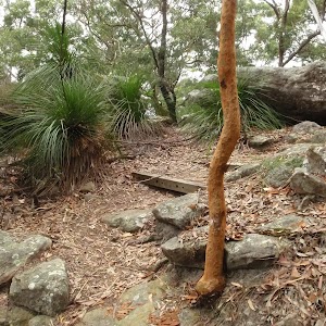
4.8 km Circuit
2 hrs 15 mins
Moderate track
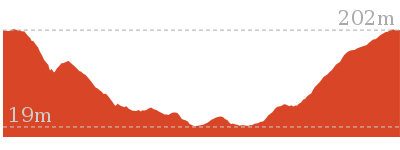
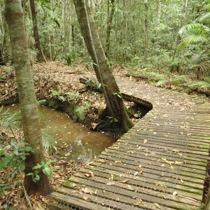
2.9 km One way
1 hr 30 mins
Moderate track
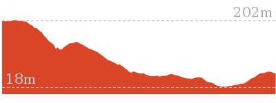
Plan your trip to and from the walk here
The Upper Rumbalara circuit walk starts and ends at the Yaruga Picnic Area BBQs (gps: -33.425486, 151.35526)
Your main transport option to Yaruga Picnic Area BBQs is by;
![]() Car. There is free parking available.
Car. There is free parking available.
(get details)
Short URL = http://wild.tl/urc
Gallery images
There are other downloads I am still working on.
You will probably need to login to access these — still all free.
* KML (google earth file)
* GPX (GPS file)
Special Maps/ brochures
* A3 topo maps
* PDF with Lands Topo map base
* PDF with arial image (and map overlay)
I wanted to get the main site live first, this extra stuff will come in time.
Happy walking
Matt 🙂
Comments