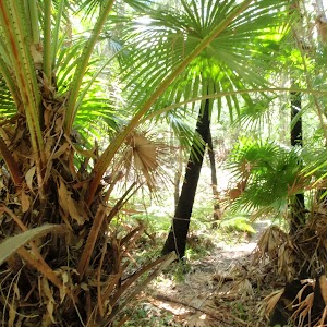
This walk starts at Caves Beach and travels south along the coastline to Pinneys Beach. The walk then heads west, up and over the Wallarah Pennisula to Murrays Beach on the foreshore of Lake Macquarie. Both the Spoon Rocks Spit and Pinney’s Headland side trips are worthwhile excursions. The palm gully rainforest, as you journey to the west, is a lovely surprise as well. At Murray’s Beach, take some time to relax in the excellent facilities there. A wonderful walk, full of variety.
Wallarah Pennisula Walk
And Walk
Wallarah Pennisula Walk


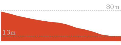
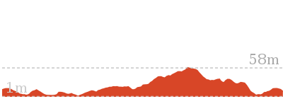
2 hrs 45 mins
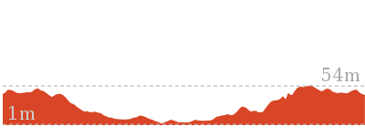
7.8 km One way

204 m
Hard track


Wallarah Pennisula
Wallarah Penisula, also referred to as the Swansea Pennisula, is surrounded by water and includes the Wallarah National Park. The Wallarah Pennisula stretches from Lake Macquarie in the west to the ocean in the east, from Swansea and Caves Beach in the north to Catherine Hill Bay and Lake Munmorah in the south. Within the Wallarah National Park, there are plenty of things to do, including walking, fishing, swimming and surfing. The coastal views are spectacular, and this is also a good whale watching spot. The Wallarah National Park co-operates with its park neighbours, including Stockland Wallarah Peninsula Pty Ltd, on a wide range of issues relating to the management of the Wallarah Peninsula through a joint management agreement.
Stuart Chalmers Park
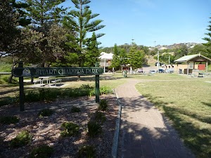
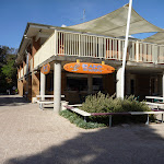
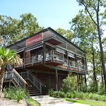
Named after a cancer victim, Stuart Chalmers Park is a well established park close to Caves Beach. Stuart Chalmers Park has toilets[2], car parking[3], water, sheltered electric barbeques[4] and picnic tables[5]. The park has easy access to Caves Beach, the cafe Acquablu[6] and the Caves Beach SLSC.
Caves Beach SLSC
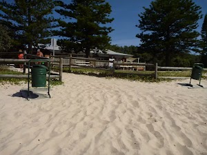
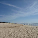
The Swansea-Caves Beach Surf Life Saving Club, south of Newcastle, was founded in 1929. The SLSC looks after Caves Beach, which runs from this southern end of the beach, for 300m to the northern Swansea (Hams) Beach. A road runs the length of the beach, with car parking along much of it. Though Caves Beach faces the south-east, it is afforded a moderate degree of wave protection by reefs in the centre and north and Spoon Rocks to the south-east. More info.
(0km) Cafe Acquablu on Caves Beach → Bottom of timber steps on Caves Beach

90 m
2 mins
1m
-2m
Moderate track
(0.09km) Bottom of timber steps on Caves Beach → Caves Beach Lookout
160 m
3 mins
6m
-6m
Hard track
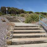
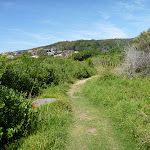
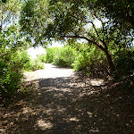
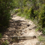
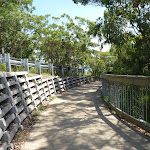
Continue straight: From the bottom of the timber steps[11] on Caves Beach, this walk follows the steps up[12], leaving the beach behind. This walk continues for about 50m up the concrete and timber steps[13], until coming to a four-way intersection[14] (with uphill concrete steps[15] directly ahead).
Turn left: From the intersection[16][17], this walk follows the footpath gently uphill[18], while keeping the downhill concrete steps[19] and beach on your left. This walk continues for about 60m until coming to a three-way intersection[20][21] with a concrete footpath on the right.
Veer left: From the intersection[22][23], this walk follows the footpath gently downhill, while keeping the ocean on your left. This walk continues for about 50m, undulating gently through coastal vegetation and crossing over a timber footbridge[24], until coming to the circular concrete structure[25] of Caves Beach Lookout[26].
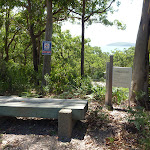
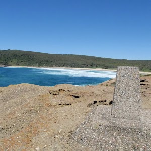
Caves Beach Lookout
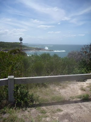
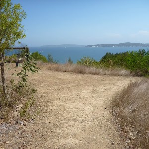
The Cave Beach Lookout, on the southern headland of Caves Beach, is easily accessible via wheelchair from the car park nearby. The lookout offers excellent views[27] over the caves of Caves Beach and also to the north and south. There are is a large stone viewing platform[28] on which to sit and enjoy the views.
(0.25km) Caves Beach Lookout → Int of Coastal Walk & Seacliff track
910 m
17 mins
27m
-22m
Hard track
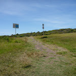
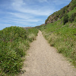
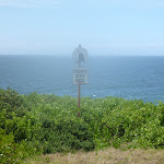
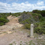
Turn sharp right: From Caves Beach Lookout[29], this walk follows the gravel and grass track gently uphill[30], while keeping the ocean on your left. This walk continues, undulating gently through coastal vegetation[31] for about 300m, until coming to Caves Beach Road[32].
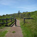
Turn left: From the intersection[33][34], this walk follows the track beside Caves Beach Road gently downhill, while keeping the ocean on your left. This walk continues for about 110m, to find the track gently uphill[35][36] and moving away from Caves Beach Road. Then the walk continues for about 100m and passes between a metal posted fence[37]. This walk continues for about 400m, undulating through coastal vegetation[38] with views[39] on the left, until passing over a timber footbridge[40] and coming to a three-way intersection with a concrete footpath[41] on the right.
Turn left: From the intersection[33][34], this walk follows the track beside Caves Beach Road gently downhill, while keeping the ocean on your left. This walk continues for about 110m, to find the track gently uphill[35][36] and moving away from Caves Beach Road. Then the walk continues for about 100m and passes between a metal posted fence[37]. This walk continues for about 400m, undulating through coastal vegetation[38] with views[39] on the left, until passing over a timber footbridge[40] and coming to a three-way intersection with a concrete footpath[41] on the right.
(1.16km) Int of Coastal Walk & Seacliff track → Int of Coastal Walk & Spoon Rocks Track
280 m
5 mins
6m
-10m
Hard track
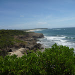
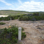
Veer left: From the intersection[42], this walk follows the bitumen track gently downhill[43], while keeping the concrete footpath on your right. This walk continues for about 120m through coastal vegetation[44] with views[45] of Spoon’s Rocks on the left, to pass through metal posts[46] and onto a sandy track[47]. Then the walk continues for about 160m, until climbing gently[48] up to the land end of Spoon Rocks Spit[49].
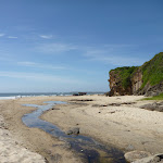
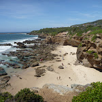
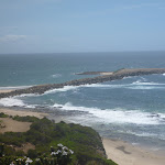
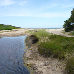
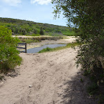
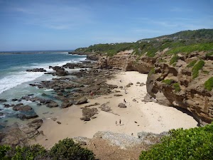
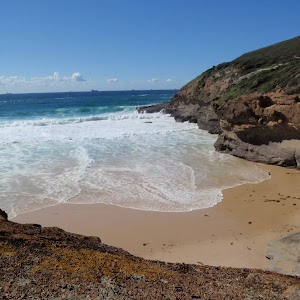
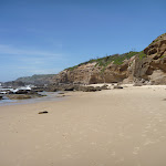
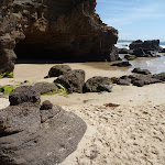
Spoon Rocks Beach
Spoon Rocks Beach, south of Caves Beach is a sheltered sandy beach[50]. Spoon Rocks breakwater[51] forms the southern end of the beach and has allowed sedimentation of sand to occur and created this attractive beach[52]. The beach is 300m long, faces north-east and is good for swimming. The Spoon Rocks Beach is worth the walk in to it.
(1.44km) Int of Coastal Walk & Spoon Rocks Track → End of Spoon Rocks Spit
470 m
8 mins
2m
-8m
Hard track
Turn left: From the intersection[53][54], this walk follows the rocky Spoon Rocks Spit out to its end, while moving directly away from the main coastline. This walk continues to follow the rocky spit (initially keeping to the Spoon Rocks Beach side[55][56] of the spit) for about 500m, until coming to the end of Spoon Rocks Spit[57][58]. This track is rocky and exposed to the ocean. At the end of this side trip, retrace your steps back to the main walk then Continue straight.
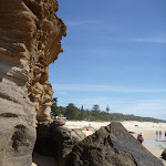
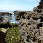
Spoon Rocks Spit
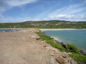
Spoon Rocks Spit is a wide breakwater[59] extending 500m out into the ocean. This breakwater was originally designed as a coal loading facility to offload coal mined from the nearby Wallarah seam. The rocks were cut from the cliff face below the spit. Over time, the force of the ocean waves have breached the breakwater. Sedimentation from these ocean forces has established a safe and protected swimming and beach[60] area to the north of the spit.
(1.44km) Int of Coastal Walk & Spoon Rocks Track → Int of Coastal Walk & Quarries Track
340 m
7 mins
20m
-3m
Moderate track
Turn right: From the intersection[61][62], this walk follows the track gently uphill[63], while leaving Spoon Rocks Spit and the ocean on your left. This walk continues for about 400m (ignoring side tracks[64]) through coastal vegetation and becoming moderately steep uphill[65], until coming to a three-way intersection with a bridged track[66] and ‘Wallarah Peninsula Coastal Walk’ sign[67] on the left.
(1.78km) Int of Coastal Walk AND Quarries Track → Pinneys Viewpoint
990 m
21 mins
36m
-49m
Hard track
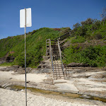
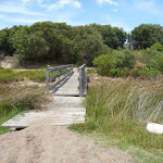
Turn left: From the intersection[68], this walk crosses a footbridge and follows the moderately steep uphill track[69], while passing the ‘Wallarah Peninsula Coastal Walk’ sign[70] on your left. This walk continues for about 140m, then climbs up timber steps[71] to a viewing spot[72] over Spoon Rocks Spit. Then the walk continues for about 20m, to a three-way intersection[73]. This walk turns left, following the arrow marker on a timber post[74]. Then this walk continues for about 400m, as the track undulates gently downhill with views and a metal fence[75] on your left, to pass through a timber fenced opening[76]. The walk then continues moderately steeply downhill[77], initially with a timber fence on your right for about 80m to find blank information signs[78] at Split Rocks Headland. The walk continues gently downhill for about 300m, with a short section of timber boardwalk[79] and views of Pinney’s Beach[80], until coming to a timber viewing platform and Pinney’s Lookout[81].
Pinneys Lookout
(2.78km) Pinneys Viewpoint → Int of Coastal Walk & Pinneys Beach
180 m
3 mins
0m
-3m
Moderate track
Continue straight: From Pinney’s Viewpoint[85], this walk follows the track gently downhill[86], while keeping Pinney’s Beach on your left. This walk continues for about 70m, including one section of timber boardwalk[87], until coming to a T-intersection[88] with a narrow management trail[89] and blank sign on the right.
Turn left: From the intersection[90], this walk follows Pinneys Trail gently downhill[91], while keeping the track with a blank sign on your left[92]. This walk continues for about 100m through coastal vegetation, until crossing Pinney’s Creek via a timber footbridge[93] and coming to a three-way intersection[94], with Pinney’s Beach on the left.
Turn left: From the intersection[90], this walk follows Pinneys Trail gently downhill[91], while keeping the track with a blank sign on your left[92]. This walk continues for about 100m through coastal vegetation, until crossing Pinney’s Creek via a timber footbridge[93] and coming to a three-way intersection[94], with Pinney’s Beach on the left.
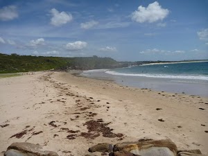
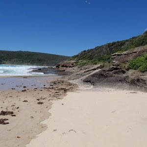
Pinneys Beach
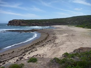
Pinney’s Beach is a good beach for fishing, surfing and swimming. This beach is accessible on foot, via the coastal walk. This beach is not patrolled and rock platforms[95] can be dangerous, even when the seas appear calm. Personal fishing is permitted off all the coast in Wallarah National Park, although a licence is needed. A midden (dated to about 1200 years old), with about 20 stone artefacts, was discovered here in the 1960s, but unfortunately 4WD vehicles have caused erosion to this site. More info.
(2.96km) Int of Coastal Walk AND Pinneys Beach → Int of Coastal Walk AND Wallarah Walk
320 m
5 mins
1m
0m
Moderate track
Turn right: From the intersection[96][97], this walk follows the trail gently uphill, while leaving the bridge and creek on your right. This walk continues for about 160m, passing around a locked gate[98]. Then this walk continues through coastal bush for about 150m, until coming to a three-way intersection[99], with a ‘Coastal Walk’ sign[100].
(3.28km) Int of Coastal Walk & Wallarah Walk → Int of Coastal Track & Pinneys Lookout
850 m
17 mins
34m
-21m
Moderate track
Turn left: From the intersection[101], this walk follows the ‘Coastal Walk’ sign[102] gently uphill. This walk continues moderately steeply uphill[103] for about 400m, and comes to a three-way intersection[104]. Then this walk tends left, following an arrow marker on a timber post, and after about 40m, comes to a three-way intersection. This walk tends left, following an arrow marker on a timber post, for about 80m, coming to a three-way intersection with the gently downhill Shark Bay trail on the right.
Continue straight: From the intersection[105], this walk follows the trail gently downhill[106] to the left, while keeping the gently downhill[107] Sharks Bay trail on your right. This walk continues, undulating gently for about 110m, until coming to a three-way intersection[108], with a arrow marker[109] on the left.
Veer left: From the intersection[110], this walk turns left on the trail and follows the timber arrow marker gently downhill. This walk continues, undulating gently[111] for about 180m, until coming to a timber fence[112] and Pinney’s Lookout[113] on the left (just as the trail turns right[114]). At the end of this side trip, retrace your steps back to the main walk then Veer left.
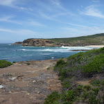
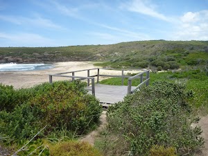
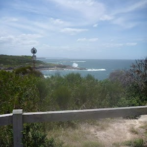
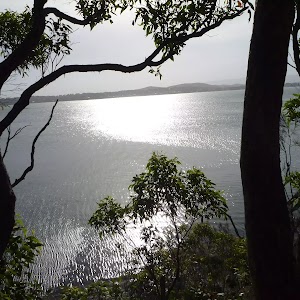
Pinney’s Headland Lookout
There are magnificent vistas from Pinney’s Headland Lookout[115], particularly to the north. The headland is accessed on foot via the Wallarah Peninsula coastal walk[116], and the headland itself has a loop walking trail on it. At the southernmost point of this walking loop, there are unfenced rock platforms forming the ocean shoreline – take care. More info.
(3.28km) Int of Coastal Walk & Wallarah Walk → Int of Wallarah Walk & Heath Track
540 m
10 mins
15m
-8m
Moderate track
Veer right: From the intersection[117][118], this walk follows the unsignposted trail gently downhill[119] towards the creek bed[120][121]. This walk continues for about 35m, to cross the gravelly creek bed[122]. Then this walk continues gently uphill[123] through native bush for about 180m, until coming to a level three-way intersection[124], with a trail and timber arrow marker[125] indicating a right turn.
Turn right: From the intersection[126], this walk follows the timber arrow marker[127] and trail gently uphill. This walk continues, undulating for about 160m, to cross a rocky creek[128] with a ‘Wallarah National Park’ sign[129] on the right. Then this walk continues gently uphill[130] (ignoring side trails[131]) for about 140m, until coming to a three-way intersection[132], with a timber arrow sign[133] pointing left.
Turn right: From the intersection[126], this walk follows the timber arrow marker[127] and trail gently uphill. This walk continues, undulating for about 160m, to cross a rocky creek[128] with a ‘Wallarah National Park’ sign[129] on the right. Then this walk continues gently uphill[130] (ignoring side trails[131]) for about 140m, until coming to a three-way intersection[132], with a timber arrow sign[133] pointing left.
(3.82km) Int of Wallarah Walk & Heath Track → Int of Wallarah Walk and Ridge Track
1.1 km
24 mins
72m
-11m
Moderate track
Turn left: From the intersection[134], this walk follows the timber arrow post[135] north on the gently uphill trail. This walk continues, undulating through open heath vegetation[136] and passing timber arrow markers[137] for about 280m, until coming to a T-intersection[138], with a timber arrow marker[139] indicating a left turn.
Turn left: From the intersection[140][141], this walk follows the trail gently uphill[142], while following the timber arrow marker. This walk continues, ignoring side trails, and crosses a creek[143] amongst palm trees after about 150m. Then the walk continues moderately steeply uphill[144] on an eroded trail[145] through native bush for about 700m (becoming gentle uphill[146]), until coming to a three-way intersection[147], with a track[148] on the left and timber steps[149] on the right (passing a ‘Wallarah National Park’ sign on the right).
Turn left: From the intersection[140][141], this walk follows the trail gently uphill[142], while following the timber arrow marker. This walk continues, ignoring side trails, and crosses a creek[143] amongst palm trees after about 150m. Then the walk continues moderately steeply uphill[144] on an eroded trail[145] through native bush for about 700m (becoming gentle uphill[146]), until coming to a three-way intersection[147], with a track[148] on the left and timber steps[149] on the right (passing a ‘Wallarah National Park’ sign on the right).
(4.96km) Int of Wallarah Walk & Ridge Track → Int of Wallarah Walk & Old Pacific Hwy
190 m
4 mins
8m
-4m
Hard track
Continue straight: From the intersection[150], this walk follows the track between large rocks[151] and up the timber steps[152], while walking directly away from the ‘Wallarah National Park’ sign[153]. This walk continues for about 35m, passing between metal posts[154] at the top, until coming to the sealed and level road, Scenic Drive[155] (with a ‘Points of Interest’ sign[156] on the left).
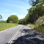
Turn left: From the intersection[157][158], this walk follows the road gently uphill, while keeping the ‘Points of Interest’ sign[159] on your left. This walk continues with overhead power lines[160] on your left for about 160m, until coming to a large disused section of bitumen road[161] at a three-way intersection.
Turn left: From the intersection[157][158], this walk follows the road gently uphill, while keeping the ‘Points of Interest’ sign[159] on your left. This walk continues with overhead power lines[160] on your left for about 160m, until coming to a large disused section of bitumen road[161] at a three-way intersection.
(5.14km) Int of Wallarah Walk & Old Pacific Hwy → Int of Old Pacific Hwy & Bridge Track
440 m
7 mins
3m
-7m
Moderate track
Turn left: From the intersection[162][163], this walk follows the road west, underneath power lines and towards a three-way intersection with a locked metal gate[164] on the left. This walk continues for about 70m, coming to a three-way intersection with a trail and locked metal gate on the left. This walk turns left and passes around the locked metal gate[165]. Then this walk continues gently downhill along the sealed old Pacific Hwy[166] (ignoring a trail[167] on the left) for about 400m, until coming to a three-way intersection[168], with a track on the right.
(5.58km) Int of Old Pacific Hwy & Bridge Track → Int of Murrays Trail & Raffertys Track
460 m
7 mins
5m
-1m
Moderate track
Turn right: From the intersection[169][170], this walk follows the track gently uphill and towards the timber barrier[171], while leaving the old Pacific Hwy directly behind. This walk continues for about 20m, to pass around the timber barrier. Then this walk crosses the metal bridge[172][173] (and Pacific Hwy) and after about 100m passes around a timber barrier[174][175], until coming to a three-way intersection[176] with a gravel trail.
Veer right: From the intersection[177][178], this walk follows the trail west[179], while keeping the bridge on your right. This walk continues, undulating gently through native bush[180][181] for about 300m, until coming to a three-way intersection[182], with a timber arrow marker[183] indicating a right turn.
Veer right: From the intersection[177][178], this walk follows the trail west[179], while keeping the bridge on your right. This walk continues, undulating gently through native bush[180][181] for about 300m, until coming to a three-way intersection[182], with a timber arrow marker[183] indicating a right turn.
(6.04km) Int of Murrays Trail & Raffertys Track → Int of Murrays Trail & Jetty Point Drive
780 m
13 mins
3m
-14m
Hard track
Turn right: From the intersection[184][185], this walk follows the timber arrow marker[186] north on the gently uphill trail. This walk continues through native bush[187] (ignoring side trails) for about 300m, to come to a three-way intersection[188] with yellow metal safety posts[189]s and track on the left. Then this walk turns right, down the moderately steep trail[190] (becoming gently downhill) for about 400m, to find a large green water tank[191][192]. This walk then continues for about 90m, passing the water tank[193] initially on your left, until crossing Jetty Point Drive[194][195] and coming to a three-way intersection with a concrete footpath[196][197] and timber arrow marker indicating a left turn.
(6.82km) Int of Murrays Trail & Jetty Point Drive → Int of Jetty Point Drive & Shoreside Row
790 m
15 mins
1m
-64m
Moderate track
Turn left: From the intersection[198][199], this walk follows the footpath and timber arrow marker gently downhill[200], while keeping Jetty Point Drive on your left. This walk continues for about 400m, with views[201] on the right at one stage, then crosses Lake Ridge Lane[202]. Then this walk continues on the footpath, with Jetty Point Drive on your left and amongst new houses[203], for about 240m, to find Stockland Murrays Beach Reserve[204][205]. Then this walk crosses the reserve and, after about 110m, comes to a four-way intersection[206] with Jetty Point Drive and a gravel footpath and ‘The Lake House Cafe’ sign[207] ahead.
(7.6km) Int of Jetty Point Drive & Shoreside Row → The Lake House Cafe
50 m
1 mins
0m
-2m
Moderate track
The Lake House Cafe (Murrays Beach)
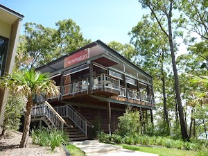
The Lake House Cafe at Murrays Beach offers an award winning dining experience with excellent views[211] out across Murrays Beach and Lake Macquarie. The Lake House Cafe is open 7 days (7am – 4pm) for breakfast and lunch. It is also open for dinner on Fridays and Saturdays from 6pm. The Cafe is open every day, except Christmas Day. The Lake House Cafe is located at 11 Shoreside Row, Caves Beach NSW 2281, Australia. Phone +61 2 4971 1745. More info.
(7.6km) Int of Jetty Point Drive & Shoreside Row → Murrays Beach Jetty
210 m
3 mins
0m
-6m
Moderate track
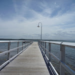
Continue straight: From the intersection[212][213], this walk follows the gravel footpath[214] and ‘the Lake House Cafe’ sign[215] gently downhill through open native trees[216] and towards Lake Macquarie. This walk continues for about 180m, down timber steps[217] and through open lawn areas with numerous footpaths[218], keeping the Lake House Cafe on your left, until coming to the public Murrays Beach jetty[219] on Lake Macquarie.
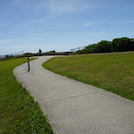
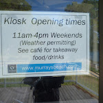
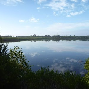
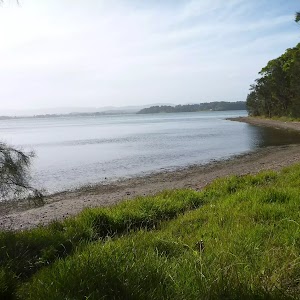
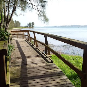
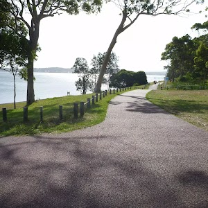
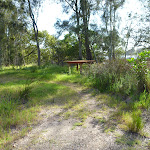
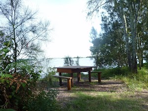
Murrays Beach Picnic Area
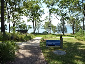
The Murrays Beach Picnic Area on the shores of Lake Macquarie provide a picturesque spot for picnics with family and friends. There are well maintained grasslands[220] amongst open forest with a public jetty[221], a kiosk[222], a toilet[223], water, a children’s playground[224] and picnic tables[225]. The kiosk is open 11am till 4pm on weekends, otherwise the Lake House Cafe can be used. Excellent easy walks are available to the north and south along the lake foreshore[226]. More info.
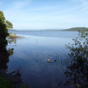
Murrays Beach
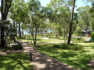
Murrays Beach is an idyllic residential development. Recently developed with the environment as a core philosophy, the developer, Stockland Murray Beach was awarded the Residential Lifestyle Development of the Year, 2008, by the HIA. Murrays Beach has a vibrant village green[227], jetty[228], kiosk[229], foreshore picnic area[230], children’s playground[231], barbeque’s and bush walking trails[232]. With its magnificent natural setting and tasteful facilities a trip to Murrays Beach is well worth a visit. [233] More info.
Maps for the Wallarah Pennisula Walk walk
You can download the PDF for this walk to print a map.
These maps below cover the walk and the wider area around the walk, they are worth carrying for safety reasons.
| Catherine Hill Bay | 1:25 000 Map Series | 92314S CATHERINE HILL BAY | NSW-92314S |
| Swansea | 1:25 000 Map Series | 92314N SWANSEA | NSW-92314N |
| Lake Macquarie | 1:100 000 Map Series | 9231 LAKE MACQUARIE | 9231 |
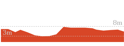
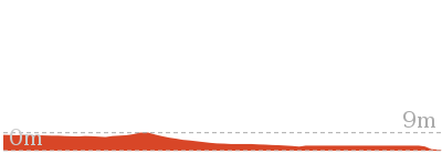
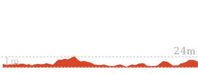
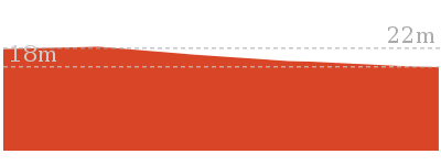
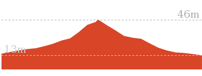
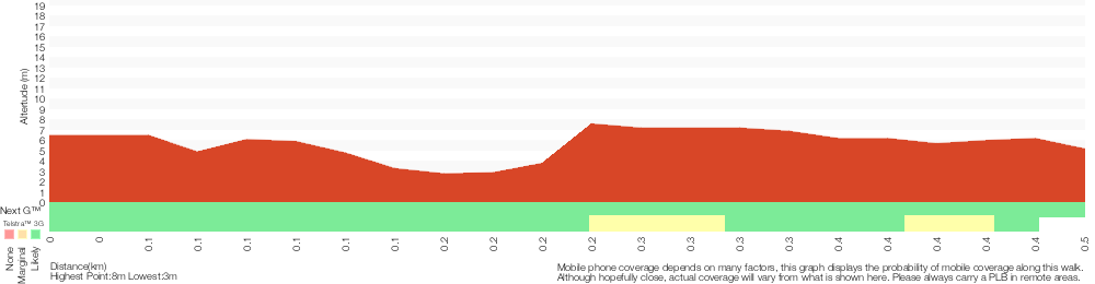
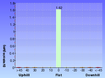
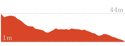
Cross sectional view of the Wallarah Pennisula Walk bushwalking track
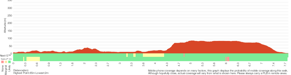
Analysis and summary of the altitude variation on the Wallarah Pennisula Walk
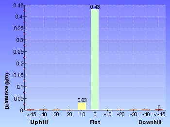
Overview of this walks grade – based on the AS 2156.1 – 2001
Under this standard, a walk is graded based on the most difficult section of the walk.
| Length | 7.8 km | ||
| Time | 2 hrs 45 mins | ||
| . | |||
| Grade 4/6 Hard track |
AS 2156.1 | Gradient | Very steep (4/6) |
| Quality of track | Formed track, with some branches and other obstacles (3/6) | ||
| Signs | Minimal directional signs (4/6) | ||
| Experience Required | Some bushwalking experience recommended (3/6) | ||
| Weather | Weather generally has little impact on safety (1/6) | ||
| Infrastructure | Limited facilities (such as cliffs not fenced, significant creeks not bridged) (4/6) |
Some more details of this walks Grading
Here is a bit more details explaining grading looking at sections of the walk
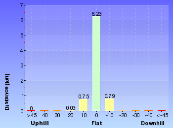
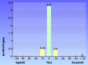
Gradient
4.2km of this walk has short steep hills and another 3.6km has gentle hills with occasional steps. The remaining (40m) is very steep.
Quality of track
5km of this walk follows a formed track, with some branches and other obstacles and another 1.2km follows a clear and well formed track or trail. The remaining (1.2km) follows a smooth and hardened path.
Signs
Around 4.8km of this walk has directional signs at most intersection, whilst the remaining 3km has minimal directional signs.
Experience Required
Around 4.8km of this walk requires no previous bushwalking experience, whilst the remaining 3.1km requires some bushwalking experience.
weather
This whole walk, 8km is not usually affected by severe weather events (that would unexpectedly impact safety and navigation).
Infrastructure
6km of this walk has limited facilities (such as not all cliffs fenced) and another 1.9km is close to useful facilities (such as fenced cliffs and seats). The remaining (280m) has limited facilities (such as cliffs not fenced, significant creeks not bridged).
Similar walks
A list of walks that share part of the track with the Wallarah Pennisula Walk walk.
904 m Return
30 mins
Hard track
8.3 km Return
3 hrs
Hard track
Other Nearby walks
A list of walks that start near the Wallarah Pennisula Walk walk.
3.2 km Return
1 Hr
Moderate track
3.2 km Return
1 Hr
Moderate track
768 m Return
20 mins
Hard track
7.7 km Circuit
3 hrs
Hard track
2.9 km One way
1 hr 15 mins
Hard track
2.4 km Circuit
1 Hr
Moderate track
280 m Return
10 mins
Moderate track
630 m Return
15 mins
Experienced only
3.4 km Circuit
2 hrs 45 mins
Moderate track

3 km Return
1 hr 15 mins
Moderate track
609 m Circuit
20 mins
Moderate track
862 m One way
30 mins
Experienced only
Plan your trip to and from the walk here
The Wallarah Pennisula Walk walk starts at the Cafe Acquablu on Caves Beach (gps: -33.110225, 151.64631)
Your transport options to Cafe Acquablu on Caves Beach are by;
![]() Bus. (get details)
Bus. (get details)
![]() Car. There is free parking available.
Car. There is free parking available.
(get details)
The Wallarah Pennisula Walk ends at the Murrays Beach Jetty (gps: -33.1137, 151.61398)
Your transport options to Murrays Beach Jetty are by;
![]() Bus. (get details)
Bus. (get details)
![]() Car. There is free parking available.
Car. There is free parking available.
(get details)


Short URL = http://wild.tl/wpw
Gallery images
There are other downloads I am still working on.
You will probably need to login to access these — still all free.
* KML (google earth file)
* GPX (GPS file)
Special Maps/ brochures
* A3 topo maps
* PDF with Lands Topo map base
* PDF with arial image (and map overlay)
I wanted to get the main site live first, this extra stuff will come in time.
Happy walking
Matt 🙂
Wallarah Coastal Walk
And Walk
Wallarah Coastal Walk

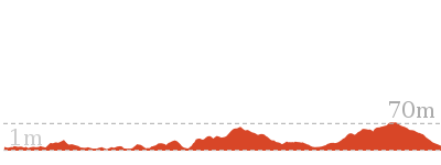
3 hrs
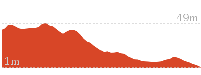
8.3 km Return
247 m
Hard track
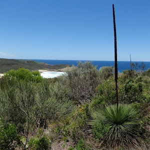
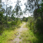
This walk starts at Caves Beach and travels south along the coastline, until reaching the Pinney’s Headland Lookout. There are many opportunities to stop, relax and swim if you would like. You will meander through coastal heath vegetation, which offers abundant wildflowers during springtime. There are spectacular views over the coast and the side trip to Spoon Rocks Spit offers a chance to look back at the attractive coastline. This walk takes you into a seldom visited part of Wallarah Pennisula.


Wallarah Pennisula
Wallarah Penisula, also referred to as the Swansea Pennisula, is surrounded by water and includes the Wallarah National Park. The Wallarah Pennisula stretches from Lake Macquarie in the west to the ocean in the east, from Swansea and Caves Beach in the north to Catherine Hill Bay and Lake Munmorah in the south. Within the Wallarah National Park, there are plenty of things to do, including walking, fishing, swimming and surfing. The coastal views are spectacular, and this is also a good whale watching spot. The Wallarah National Park co-operates with its park neighbours, including Stockland Wallarah Peninsula Pty Ltd, on a wide range of issues relating to the management of the Wallarah Peninsula through a joint management agreement.
Stuart Chalmers Park
Named after a cancer victim, Stuart Chalmers Park is a well established park close to Caves Beach. Stuart Chalmers Park has toilets[2], car parking[3], water, sheltered electric barbeques[4] and picnic tables[5]. The park has easy access to Caves Beach, the cafe Acquablu[6] and the Caves Beach SLSC.
Caves Beach SLSC
The Swansea-Caves Beach Surf Life Saving Club, south of Newcastle, was founded in 1929. The SLSC looks after Caves Beach, which runs from this southern end of the beach, for 300m to the northern Swansea (Hams) Beach. A road runs the length of the beach, with car parking along much of it. Though Caves Beach faces the south-east, it is afforded a moderate degree of wave protection by reefs in the centre and north and Spoon Rocks to the south-east. More info.
(0km) Cafe Acquablu on Caves Beach → Four way intersection (caves beach)
140 m
3 mins
6m
-2m
Hard track
From Cafe Acquablu[7], this walk leaves the concrete footpath and enters Caves Beach[8], turning to the right. This walk then follows the sandy beach, keeping the ocean on your left, and after about 80m, crosses a small creek[9] and comes to the bottom of timber steps[10].
Continue straight: From the bottom of the timber steps[11] on Caves Beach, this walk follows the steps up[12], leaving the beach behind. This walk continues for about 50m up the concrete and timber steps[13], until coming to a four-way intersection[14] (with uphill concrete steps[15] directly ahead).
Continue straight: From the bottom of the timber steps[11] on Caves Beach, this walk follows the steps up[12], leaving the beach behind. This walk continues for about 50m up the concrete and timber steps[13], until coming to a four-way intersection[14] (with uphill concrete steps[15] directly ahead).
(0.14km) Four way intersectin (Caves Beach) → Caves Beach Lookout
120 m
2 mins
1m
-6m
Moderate track
Turn left: From the intersection[16][17], this walk follows the footpath gently uphill[18], while keeping the downhill concrete steps[19] and beach on your left. This walk continues for about 60m until coming to a three-way intersection[20][21] with a concrete footpath on the right.
Veer left: From the intersection[22][23], this walk follows the footpath gently downhill, while keeping the ocean on your left. This walk continues for about 50m, undulating gently through coastal vegetation and crossing over a timber footbridge[24], until coming to the circular concrete structure[25] of Caves Beach Lookout[26].
Veer left: From the intersection[22][23], this walk follows the footpath gently downhill, while keeping the ocean on your left. This walk continues for about 50m, undulating gently through coastal vegetation and crossing over a timber footbridge[24], until coming to the circular concrete structure[25] of Caves Beach Lookout[26].
Caves Beach Lookout
The Cave Beach Lookout, on the southern headland of Caves Beach, is easily accessible via wheelchair from the car park nearby. The lookout offers excellent views[27] over the caves of Caves Beach and also to the north and south. There are is a large stone viewing platform[28] on which to sit and enjoy the views.
(0.25km) Caves Beach Lookout → Int of Coastal Walk & Seacliff track
910 m
17 mins
27m
-22m
Hard track
Turn sharp right: From Caves Beach Lookout[29], this walk follows the gravel and grass track gently uphill[30], while keeping the ocean on your left. This walk continues, undulating gently through coastal vegetation[31] for about 300m, until coming to Caves Beach Road[32].
Turn left: From the intersection[33][34], this walk follows the track beside Caves Beach Road gently downhill, while keeping the ocean on your left. This walk continues for about 110m, to find the track gently uphill[35][36] and moving away from Caves Beach Road. Then the walk continues for about 100m and passes between a metal posted fence[37]. This walk continues for about 400m, undulating through coastal vegetation[38] with views[39] on the left, until passing over a timber footbridge[40] and coming to a three-way intersection with a concrete footpath[41] on the right.
Turn left: From the intersection[33][34], this walk follows the track beside Caves Beach Road gently downhill, while keeping the ocean on your left. This walk continues for about 110m, to find the track gently uphill[35][36] and moving away from Caves Beach Road. Then the walk continues for about 100m and passes between a metal posted fence[37]. This walk continues for about 400m, undulating through coastal vegetation[38] with views[39] on the left, until passing over a timber footbridge[40] and coming to a three-way intersection with a concrete footpath[41] on the right.
(1.16km) Int of Coastal Walk & Seacliff track → Int of Coastal Walk & Spoon Rocks Track
280 m
5 mins
6m
-10m
Hard track
Veer left: From the intersection[42], this walk follows the bitumen track gently downhill[43], while keeping the concrete footpath on your right. This walk continues for about 120m through coastal vegetation[44] with views[45] of Spoon’s Rocks on the left, to pass through metal posts[46] and onto a sandy track[47]. Then the walk continues for about 160m, until climbing gently[48] up to the land end of Spoon Rocks Spit[49].
Spoon Rocks Beach
Spoon Rocks Beach, south of Caves Beach is a sheltered sandy beach[50]. Spoon Rocks breakwater[51] forms the southern end of the beach and has allowed sedimentation of sand to occur and created this attractive beach[52]. The beach is 300m long, faces north-east and is good for swimming. The Spoon Rocks Beach is worth the walk in to it.
(1.44km) Int of Coastal Walk & Spoon Rocks Track → End of Spoon Rocks Spit
470 m
8 mins
2m
-8m
Hard track
Turn left: From the intersection[53][54], this walk follows the rocky Spoon Rocks Spit out to its end, while moving directly away from the main coastline. This walk continues to follow the rocky spit (initially keeping to the Spoon Rocks Beach side[55][56] of the spit) for about 500m, until coming to the end of Spoon Rocks Spit[57][58]. This track is rocky and exposed to the ocean. At the end of this side trip, retrace your steps back to the main walk then Continue straight.
Spoon Rocks Spit
Spoon Rocks Spit is a wide breakwater[59] extending 500m out into the ocean. This breakwater was originally designed as a coal loading facility to offload coal mined from the nearby Wallarah seam. The rocks were cut from the cliff face below the spit. Over time, the force of the ocean waves have breached the breakwater. Sedimentation from these ocean forces has established a safe and protected swimming and beach[60] area to the north of the spit.
(1.44km) Int of Coastal Walk & Spoon Rocks Track → Int of Coastal Walk & Quarries Track
340 m
7 mins
20m
-3m
Moderate track
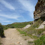
Turn right: From the intersection[61][62], this walk follows the track gently uphill[63], while leaving Spoon Rocks Spit and the ocean on your left. This walk continues for about 400m (ignoring side tracks[64]) through coastal vegetation and becoming moderately steep uphill[65], until coming to a three-way intersection with a bridged track[66] and ‘Wallarah Peninsula Coastal Walk’ sign[67] on the left.
(1.78km) Int of Coastal Walk AND Quarries Track → Pinneys Viewpoint
990 m
21 mins
36m
-49m
Hard track
Turn left: From the intersection[68], this walk crosses a footbridge and follows the moderately steep uphill track[69], while passing the ‘Wallarah Peninsula Coastal Walk’ sign[70] on your left. This walk continues for about 140m, then climbs up timber steps[71] to a viewing spot[72] over Spoon Rocks Spit. Then the walk continues for about 20m, to a three-way intersection[73]. This walk turns left, following the arrow marker on a timber post[74]. Then this walk continues for about 400m, as the track undulates gently downhill with views and a metal fence[75] on your left, to pass through a timber fenced opening[76]. The walk then continues moderately steeply downhill[77], initially with a timber fence on your right for about 80m to find blank information signs[78] at Split Rocks Headland. The walk continues gently downhill for about 300m, with a short section of timber boardwalk[79] and views of Pinney’s Beach[80], until coming to a timber viewing platform and Pinney’s Lookout[81].
Pinneys Lookout
(2.78km) Pinneys Viewpoint → Int of Coastal Walk & Pinneys Beach
180 m
3 mins
0m
-3m
Moderate track
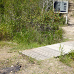
Continue straight: From Pinney’s Viewpoint[85], this walk follows the track gently downhill[86], while keeping Pinney’s Beach on your left. This walk continues for about 70m, including one section of timber boardwalk[87], until coming to a T-intersection[88] with a narrow management trail[89] and blank sign on the right.
Turn left: From the intersection[90], this walk follows Pinneys Trail gently downhill[91], while keeping the track with a blank sign on your left[92]. This walk continues for about 100m through coastal vegetation, until crossing Pinney’s Creek via a timber footbridge[93] and coming to a three-way intersection[94], with Pinney’s Beach on the left.
Turn left: From the intersection[90], this walk follows Pinneys Trail gently downhill[91], while keeping the track with a blank sign on your left[92]. This walk continues for about 100m through coastal vegetation, until crossing Pinney’s Creek via a timber footbridge[93] and coming to a three-way intersection[94], with Pinney’s Beach on the left.
Pinneys Beach
Pinney’s Beach is a good beach for fishing, surfing and swimming. This beach is accessible on foot, via the coastal walk. This beach is not patrolled and rock platforms[95] can be dangerous, even when the seas appear calm. Personal fishing is permitted off all the coast in Wallarah National Park, although a licence is needed. A midden (dated to about 1200 years old), with about 20 stone artefacts, was discovered here in the 1960s, but unfortunately 4WD vehicles have caused erosion to this site. More info.
(2.96km) Int of Coastal Walk AND Pinneys Beach → Int of Coastal Walk AND Wallarah Walk
320 m
5 mins
1m
0m
Moderate track
Turn right: From the intersection[96][97], this walk follows the trail gently uphill, while leaving the bridge and creek on your right. This walk continues for about 160m, passing around a locked gate[98]. Then this walk continues through coastal bush for about 150m, until coming to a three-way intersection[99], with a ‘Coastal Walk’ sign[100].
(3.28km) Int of Coastal Walk & Wallarah Walk → Int of Coastal Walk & Shark Bay Trail
540 m
12 mins
34m
-4m
Moderate track
Turn left: From the intersection[101], this walk follows the ‘Coastal Walk’ sign[102] gently uphill. This walk continues moderately steeply uphill[103] for about 400m, and comes to a three-way intersection[104]. Then this walk tends left, following an arrow marker on a timber post, and after about 40m, comes to a three-way intersection. This walk tends left, following an arrow marker on a timber post, for about 80m, coming to a three-way intersection with the gently downhill Shark Bay trail on the right.
(3.82km) Int of Coastal Walk & Shark Bay Track → Int of Coastal Track & Southern Loop Junction
120 m
2 mins
0m
-5m
Moderate track
Continue straight: From the intersection[105], this walk follows the trail gently downhill[106] to the left, while keeping the gently downhill[107] Sharks Bay trail on your right. This walk continues, undulating gently for about 110m, until coming to a three-way intersection[108], with a arrow marker[109] on the left.
(3.94km) Int of Coastal Track & Southern Loop Junction → Int of Coastal Track & Pinneys Lookout
190 m
3 mins
0m
-12m
Moderate track
Pinney’s Headland Lookout
There are magnificent vistas from Pinney’s Headland Lookout[115], particularly to the north. The headland is accessed on foot via the Wallarah Peninsula coastal walk[116], and the headland itself has a loop walking trail on it. At the southernmost point of this walking loop, there are unfenced rock platforms forming the ocean shoreline – take care. More info.
Maps for the Wallarah Coastal Walk walk
You can download the PDF for this walk to print a map.
These maps below cover the walk and the wider area around the walk, they are worth carrying for safety reasons.
| Catherine Hill Bay | 1:25 000 Map Series | 92314S CATHERINE HILL BAY | NSW-92314S |
| Swansea | 1:25 000 Map Series | 92314N SWANSEA | NSW-92314N |
| Lake Macquarie | 1:100 000 Map Series | 9231 LAKE MACQUARIE | 9231 |
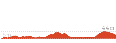
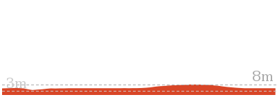
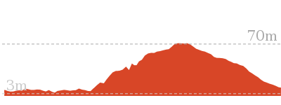
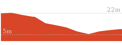
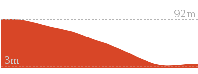
Cross sectional view of the Wallarah Coastal Walk bushwalking track
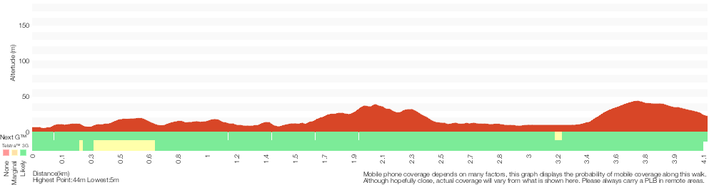
Analysis and summary of the altitude variation on the Wallarah Coastal Walk
Overview of this walks grade – based on the AS 2156.1 – 2001
Under this standard, a walk is graded based on the most difficult section of the walk.
| Length | 8.3 km | ||
| Time | 3 hrs | ||
| . | |||
| Grade 4/6 Hard track |
AS 2156.1 | Gradient | Very steep (4/6) |
| Quality of track | Formed track, with some branches and other obstacles (3/6) | ||
| Signs | Minimal directional signs (4/6) | ||
| Experience Required | Some bushwalking experience recommended (3/6) | ||
| Weather | Weather generally has little impact on safety (1/6) | ||
| Infrastructure | Limited facilities (such as cliffs not fenced, significant creeks not bridged) (4/6) |
Some more details of this walks Grading
Here is a bit more details explaining grading looking at sections of the walk
Gradient
2.2km of this walk has short steep hills and another 1.9km has gentle hills with occasional steps. The remaining (40m) is very steep.
Quality of track
Around 3.2km of this walk follows a formed track, with some branches and other obstacles, whilst the remaining 880m follows a clear and well formed track or trail.
Signs
Around 2.2km of this walk has minimal directional signs, whilst the remaining 1.9km has directional signs at most intersection.
Experience Required
Around 3.1km of this walk requires no previous bushwalking experience, whilst the remaining 1.1km requires some bushwalking experience.
weather
This whole walk, 4.1km is not usually affected by severe weather events (that would unexpectedly impact safety and navigation).
Infrastructure
3.1km of this walk has limited facilities (such as not all cliffs fenced) and another 760m is close to useful facilities (such as fenced cliffs and seats). The remaining (280m) has limited facilities (such as cliffs not fenced, significant creeks not bridged).
Similar walks
A list of walks that share part of the track with the Wallarah Coastal Walk walk.
904 m Return
30 mins
Hard track
7.8 km One way
2 hrs 45 mins
Hard track
Other Nearby walks
A list of walks that start near the Wallarah Coastal Walk walk.
3.2 km Return
1 Hr
Moderate track
3.2 km Return
1 Hr
Moderate track
768 m Return
20 mins
Hard track
7.7 km Circuit
3 hrs
Hard track
2.9 km One way
1 hr 15 mins
Hard track
2.4 km Circuit
1 Hr
Moderate track
280 m Return
10 mins
Moderate track
630 m Return
15 mins
Experienced only
3.4 km Circuit
2 hrs 45 mins
Moderate track
3 km Return
1 hr 15 mins
Moderate track
609 m Circuit
20 mins
Moderate track
862 m One way
30 mins
Experienced only
Plan your trip to and from the walk here
The Wallarah Coastal Walk walk starts and ends at the Cafe Acquablu on Caves Beach (gps: -33.110225, 151.64631)
Your transport options to Cafe Acquablu on Caves Beach are by;
![]() Bus. (get details)
Bus. (get details)
![]() Car. There is free parking available.
Car. There is free parking available.
(get details)
Short URL = http://wild.tl/wcw
Gallery images
There are other downloads I am still working on.
You will probably need to login to access these — still all free.
* KML (google earth file)
* GPX (GPS file)
Special Maps/ brochures
* A3 topo maps
* PDF with Lands Topo map base
* PDF with arial image (and map overlay)
I wanted to get the main site live first, this extra stuff will come in time.
Happy walking
Matt 🙂
Caves Beach Caves Walk
And Walk
Caves Beach Caves Walk

30 mins
904 m Return
22 m
Hard track
Caves Beach caves are just fabulous for exploring. This walk allows you to meander along the beach, looking and exploring in the many different sized and shaped caves. There are also good tidal pools to look in, making this a great walk for families. This walk requires low tide and calm sea conditions. Seek local advice before undertaking this walk. This is a must-do experience and a classic for the area.


Stuart Chalmers Park
Named after a cancer victim, Stuart Chalmers Park is a well established park close to Caves Beach. Stuart Chalmers Park has toilets[2], car parking[3], water, sheltered electric barbeques[4] and picnic tables[5]. The park has easy access to Caves Beach, the cafe Acquablu[6] and the Caves Beach SLSC.
Caves Beach SLSC
The Swansea-Caves Beach Surf Life Saving Club, south of Newcastle, was founded in 1929. The SLSC looks after Caves Beach, which runs from this southern end of the beach, for 300m to the northern Swansea (Hams) Beach. A road runs the length of the beach, with car parking along much of it. Though Caves Beach faces the south-east, it is afforded a moderate degree of wave protection by reefs in the centre and north and Spoon Rocks to the south-east. More info.
(0km) Cafe Acquablu on Caves Beach → Caves Beach Caves (first section)
360 m
7 mins
7m
-8m
Hard track
From Cafe Acquablu[7], this walk leaves the concrete footpath and enters Caves Beach[8], turning to the right. This walk then follows the sandy beach, keeping the ocean on your left, and after about 80m, crosses a small creek[9] and comes to the bottom of timber steps[10].
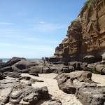
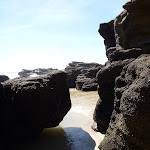
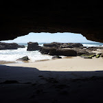
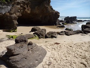
Turn left: From the bottom of the timber steps on Caves Beach, this walk follows the beach while keeping the ocean on your left. This section of the walk is only accessible at low tide and calm seas, and is a particularly hazardous area. If unsure, seek local advice at Surf Life Saving Club. This walk passes many large and attractive caves (on your right) for about 280m, until coming to a narrower section of beach between rocks[11], at the next small headland.
Turn left: From the bottom of the timber steps on Caves Beach, this walk follows the beach while keeping the ocean on your left. This section of the walk is only accessible at low tide and calm seas, and is a particularly hazardous area. If unsure, seek local advice at Surf Life Saving Club. This walk passes many large and attractive caves (on your right) for about 280m, until coming to a narrower section of beach between rocks[11], at the next small headland.
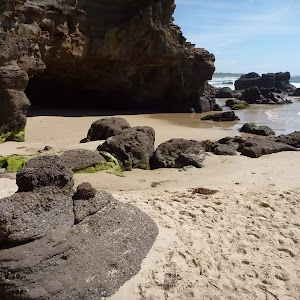
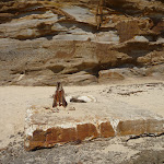
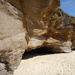
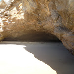
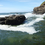
Caves at Caves Beach
Caves Beach derives its name from the sea caves[12] in the headland at it’s southern end. The caves[13] are only accessible at low tide. It is best to ask at the Caves Beach SLSC for local advice before attempting to visit the caves. The caves[14] are roughly broken into two halves, with somewhat easier access to the first section of caves, while access to the second section[15] (further to the south) is certainly restricted to low tide and light conditions. Allow time to return before the tide changes. These caves are pleasantly cool on a hot day and offer plenty of exploring potential. More info.
(0.36km) Caves Beach Caves (first section) → Caves Beach Caves (second section)
100 m
2 mins
3m
-4m
Hard track
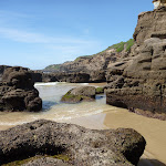
Continue straight: From the end of the first section of Caves Beach[16][17], this walk follows the beach (only at low tide, calm seas and with local advice), while keeping the ocean on your left. The walk continues for about 100m (wet feet are likely), passing more caves[18][19][20], until coming to a rock step[21] with deep water beyond[22].
Maps for the Caves Beach Caves Walk walk
You can download the PDF for this walk to print a map.
These maps below cover the walk and the wider area around the walk, they are worth carrying for safety reasons.
| Swansea | 1:25 000 Map Series | 92314N SWANSEA | NSW-92314N |
| Lake Macquarie | 1:100 000 Map Series | 9231 LAKE MACQUARIE | 9231 |
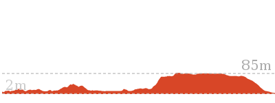
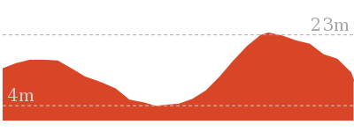
Cross sectional view of the Caves Beach Caves Walk bushwalking track
Analysis and summary of the altitude variation on the Caves Beach Caves Walk
Overview of this walks grade – based on the AS 2156.1 – 2001
Under this standard, a walk is graded based on the most difficult section of the walk.
| Length | 904 m | ||
| Time | 30 mins | ||
| . | |||
| Grade 4/6 Hard track |
AS 2156.1 | Gradient | Gentle hills with occasional steps (2/6) |
| Quality of track | Rough track, where fallen trees and other obstacles are likely (4/6) | ||
| Signs | Minimal directional signs (4/6) | ||
| Experience Required | Moderate level of bushwalking experience recommended (4/6) | ||
| Weather | Forecast, unforecast storms and severe weather may impact on navigation and safety (4/6) | ||
| Infrastructure | Limited facilities (such as cliffs not fenced, significant creeks not bridged) (4/6) |
Some more details of this walks Grading
Here is a bit more details explaining grading looking at sections of the walk
Gradient
This whole walk, 450m has gentle hills with occasional steps.
Quality of track
Around 360m of this walk follows a rough track, where fallen trees and other obstacles are likely, whilst the remaining 95m follows a clear and well formed track or trail.
Signs
Around 360m of this walk has directional signs at most intersection, whilst the remaining 95m has minimal directional signs.
Experience Required
Around 360m of this walk requires a leader a with moderate level of bushwalking experience, whilst the remaining 95m requires no previous bushwalking experience.
weather
Around 360m of this walk is affected by forecast, unforecast storms and severe weather events that may impact on navigation and safety, whilst the remaining 95m is not usually affected by severe weather events (that would unexpectedly impact safety and navigation).
Infrastructure
Around 360m of this walk has limited facilities (such as cliffs not fenced, significant creeks not bridged), whilst the remaining 95m has limited facilities (such as not all cliffs fenced).
Similar walks
A list of walks that share part of the track with the Caves Beach Caves Walk walk.
7.8 km One way
2 hrs 45 mins
Hard track
8.3 km Return
3 hrs
Hard track
Other Nearby walks
A list of walks that start near the Caves Beach Caves Walk walk.
3.2 km Return
1 Hr
Moderate track
3.2 km Return
1 Hr
Moderate track
768 m Return
20 mins
Hard track
7.7 km Circuit
3 hrs
Hard track
2.9 km One way
1 hr 15 mins
Hard track
2.4 km Circuit
1 Hr
Moderate track
280 m Return
10 mins
Moderate track
630 m Return
15 mins
Experienced only
3.4 km Circuit
2 hrs 45 mins
Moderate track
3 km Return
1 hr 15 mins
Moderate track
609 m Circuit
20 mins
Moderate track
862 m One way
30 mins
Experienced only
Plan your trip to and from the walk here
The Caves Beach Caves Walk walk starts and ends at the Cafe Acquablu on Caves Beach (gps: -33.110225, 151.64631)
Your transport options to Cafe Acquablu on Caves Beach are by;
![]() Bus. (get details)
Bus. (get details)
![]() Car. There is free parking available.
Car. There is free parking available.
(get details)
Short URL = http://wild.tl/2j
Gallery images
There are other downloads I am still working on.
You will probably need to login to access these — still all free.
* KML (google earth file)
* GPX (GPS file)
Special Maps/ brochures
* A3 topo maps
* PDF with Lands Topo map base
* PDF with arial image (and map overlay)
I wanted to get the main site live first, this extra stuff will come in time.
Happy walking
Matt 🙂
Galgabba Point Walk
And Walk
Galgabba Point Walk

1 Hr
3.2 km Return
17 m
Moderate track
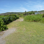
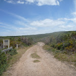
The Galgabba Point walk is a flat walk along a bush track. This walk travels through native bush before arriving at Galgabba Point, where the track forms a small loop to allow you to explore the point. Galgabba Point is home to endangered ecological communities and threatened plant species, such as the Regent Honeyeater, Swift Parrot, Squirrel Glider and many more. The walker can return back the way they came, or return via a shared walking/cycleway next to the Pacific Hwy. The Galgabba Point walk is a relaxing way to spend an hour or two.


(0km) Int of Mark St and Pacific Hwy → Int of Northern and Pacific Hwy tracks
120 m
2 mins
0m
-1m
Moderate track
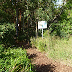
From the intersection[1][2], this walk leaves the concrete footpath and follows the track to the ‘Galgabba Point History’ sign[3], then turns left and passes between timber posts[4]. The walk continues to gently undulate along the track for about 150m, until coming to a three-way intersection[5] with a faint track[6] on your left (with the road visible through trees[7]).
(0.12km) Int of Northern & Pacific Hwy tracks → Int of Northern & Galgabba Point tracks
430 m
7 mins
3m
-2m
Moderate track
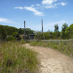
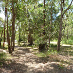
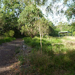
Veer right: From the intersection[8], this walk follows the track, while keeping the faint track[9][10] (to the Pacific Hwy) visible on your left. The walk continues to follow the track as it undulates for about 400m until coming to a clearing[11] and shelter[12] [13] (in the distance on the right) and shortly afterwards, a T-intersection[14] with a wide track.
(0.56km) Int of Northern & Galgabba Point tracks → Int of Borgoed Road & Pacific Hwy
140 m
2 mins
1m
0m
Moderate track
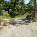
Turn left : From the intersection[15], this walk follows the track gently downhill[16], while keeping the metal shelter[17] directly behind you. The walk continues for about 120m, until passing around a metal locked gate[18] and coming to the sealed Bargoed Road[19].
Veer left: From the intersection with the locked metal gate[20][21], this walk follows the road gently uphill[22], while keeping the locked metal gate on your left. The walk continues for about 30m until coming to a T-intersection[23][24] with the Pacific Hwy.
Veer left: From the intersection with the locked metal gate[20][21], this walk follows the road gently uphill[22], while keeping the locked metal gate on your left. The walk continues for about 30m until coming to a T-intersection[23][24] with the Pacific Hwy.
(0.56km) Int of Northern & Galgabba Point tracks → Int of Galgabba Point & Galgabba Point Loop tracks
860 m
13 mins
1m
-7m
Moderate track
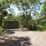
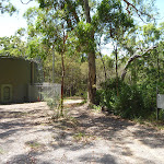
Turn right: From the intersection[25][26], this walk follows the wide track gently uphill and towards the metal shelter in the distance. The walk continues for about 20m, passing the metal shelter[27] on your right. The walk then continues to follow the track for about 400m, to find a small concrete dam[28] on the right. Then the walk continues for about 25m more, to find a three-way intersection[29] with a track on the left. The walk continues straight ahead for about 400m, until coming to a three-way intersection[30] (with a picnic table visible in the distance to the left[31]).
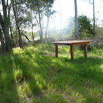
Galgabba Point Rest Area
The Galgabba Point rest area offers a picnic table with views out over Lake Macquarie, a lovely spot to watch a sunset or just sit and enjoy the natural surrounds. Galgabba Point is home to endangered ecological communities and threatened plant species, such as the Regent Honeyeater, Swift Parrot and Squirrel Glider.
There is a Galgabba Point Volunteer Bush Regeneration Team, who have helped protect this significant bushland remnant.
There is a Galgabba Point Volunteer Bush Regeneration Team, who have helped protect this significant bushland remnant.
(1.42km) Int of Loop & Galgabba Point Tracks → Int of Loop & Point Tracks
120 m
2 mins
1m
-1m
Moderate track
Veer right: From the intersection[32], this walk follows the track, while keeping the track with the picnic table[33] visible on your left. The walk continues for about 100m, until coming to a three-way intersection with a track and timber table[34] on the right. Now Veer right to rejoin the main walk .
(1.42km) Int of Galgabba Point & Galgabba Point Loop Tracks → Int of Galgabba Point Loop & Galgabba Point Tracks
150 m
2 mins
0m
-1m
Moderate track
Continue straight: From the intersection[35], this walk follows the track towards the picnic table[36][37] and water, while keeping another track on your right. The walk continues for about 25m to find a picnic table[38][39] and views[40][41] on the left. Then the walk continues straight ahead for about 120m, until coming to a timber table[42][43] at a three-way intersection with a track[44] on the left.
(1.56km) Int of Galgabba Point Loop AND Galgabba Point Tracks → Galgabba Point
60 m
1 mins
0m
-2m
Moderate track
Galgabba Point
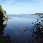
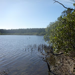
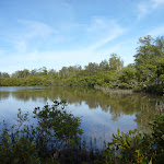
Galgabba Point is surrounded by Lake Macquarie. It is a great place to sit quietly and enjoy the natural environment. The native vegetation, including She Oak[48] and Mangroves[49] attracts bird life, such as black swans, curlews, herons and ibises. More info.
Maps for the Galgabba Point Walk walk
You can download the PDF for this walk to print a map.
These maps below cover the walk and the wider area around the walk, they are worth carrying for safety reasons.
| Swansea | 1:25 000 Map Series | 92314N SWANSEA | NSW-92314N |
| Lake Macquarie | 1:100 000 Map Series | 9231 LAKE MACQUARIE | 9231 |
Cross sectional view of the Galgabba Point Walk bushwalking track

Analysis and summary of the altitude variation on the Galgabba Point Walk
Overview of this walks grade – based on the AS 2156.1 – 2001
Under this standard, a walk is graded based on the most difficult section of the walk.
| Length | 3.2 km | ||
| Time | 1 Hr | ||
| . | |||
| Grade 3/6 Moderate track |
AS 2156.1 | Gradient | Gentle hills with occasional steps (2/6) |
| Quality of track | Clear and well formed track or trail (2/6) | ||
| Signs | Directional signs along the way (3/6) | ||
| Experience Required | No experience required (1/6) | ||
| Weather | Weather generally has little impact on safety (1/6) | ||
| Infrastructure | Limited facilities, not all cliffs are fenced (3/6) |
Some more details of this walks Grading
Here is a bit more details explaining grading looking at sections of the walk
Gradient
Around 920m of this walk has gentle hills with occasional steps, whilst the remaining 700m is flat with no steps.
Quality of track
This whole walk, 1.6km follows a clear and well formed track or trail.
Signs
This whole walk, 1.6km has directional signs at most intersection.
Experience Required
This whole walk, 1.6km requires no previous bushwalking experience.
weather
This whole walk, 1.6km is not usually affected by severe weather events (that would unexpectedly impact safety and navigation).
Infrastructure
This whole walk, 1.6km has limited facilities (such as not all cliffs fenced).
Similar walks
A list of walks that share part of the track with the Galgabba Point Walk walk.
Other Nearby walks
A list of walks that start near the Galgabba Point Walk walk.
904 m Return
30 mins
Hard track
8.3 km Return
3 hrs
Hard track
7.8 km One way
2 hrs 45 mins
Hard track
3.2 km Return
1 Hr
Moderate track
7.7 km Circuit
3 hrs
Hard track
2.9 km One way
1 hr 15 mins
Hard track
2.4 km Circuit
1 Hr
Moderate track
3.4 km Circuit
2 hrs 45 mins
Moderate track
3 km Return
1 hr 15 mins
Moderate track
2.4 km Return
1 Hr
Moderate track
3.8 km Circuit
1 hr 30 mins
Hard track
666 m Circuit
30 mins
Moderate track
Plan your trip to and from the walk here
The Galgabba Point Walk walk starts and ends at the Int of Mark St and Pacific Hwy (gps: -33.095541, 151.62959)
Your transport options to Int of Mark St and Pacific Hwy are by;
![]() Bus. (get details)
Bus. (get details)
![]() Car. There is free parking available.
Car. There is free parking available.
(get details)
Short URL = http://wild.tl/2k
Gallery images
There are other downloads I am still working on.
You will probably need to login to access these — still all free.
* KML (google earth file)
* GPX (GPS file)
Special Maps/ brochures
* A3 topo maps
* PDF with Lands Topo map base
* PDF with arial image (and map overlay)
I wanted to get the main site live first, this extra stuff will come in time.
Happy walking
Matt 🙂
Comments