The Weeping Rock and Fletchers Lookout Tracks


45 mins

88 m
Moderate track


(0km) Wentworth Falls Picnic Area Entrance → Wentworth Falls Lookout

260 m
6 mins
1m
-18m
Moderate track
Veer right: From the Entrance of the Wentworth Falls Lookout Picnic Area (at the intersection of Falls Rd and Burrell Dr), this walk follows the ‘Wentworth Falls Lookout 100m’ sign downhill along the track, passing the old picnic shelter. Soon the track becomes steeper and heads down a series of log steps until coming to and crossing Sir H Burrell Drive. On the other side of the road is the signposted ‘Wentworth Falls Lookout’.
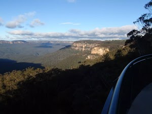
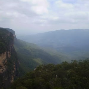
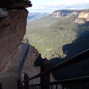
Wentworth Falls Lookout
(0.26km) Wentworth Falls Lookout → Int of Wentworth Falls and Weeping Rock Tracks (Nth)
330 m
8 mins
4m
-52m
Easy track
Turn left: From the intersection, this walk heads downhill following the ‘Wentworth Falls – National Pass’ sign. The walk gradually descends the well-maintained log stairs, passing some views of the valley on the right. Soon the track comes to an intersection with another sign, pointing back up to ‘Wentworth Falls Picnic Area’.
(0.59km) Int of Wentworth Falls and Weeping Rock Tracks (Nth) → Int of Charles Darwin and Weeping Rock Tracks
40 m
1 mins
1m
-2m
Easy track
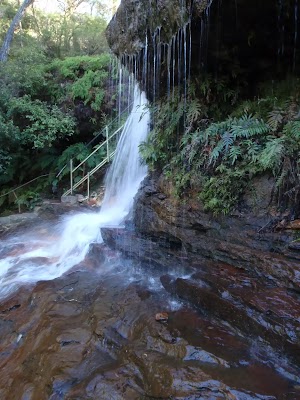
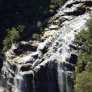
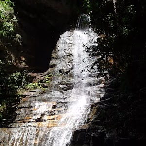
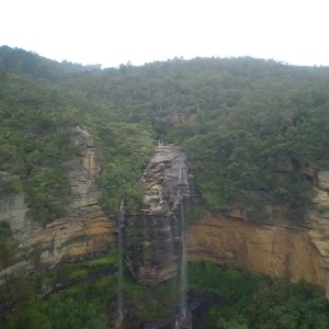
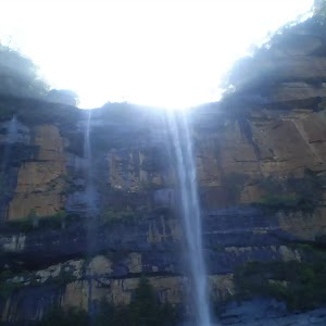
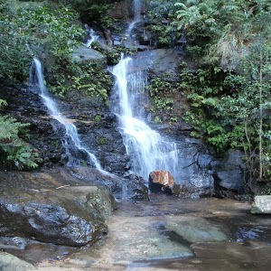
(0.63km) Int of Charles Darwin and Weeping Rock Tracks → Weeping Rock waterfall
40 m
1 mins
0m
-2m
Moderate track
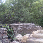
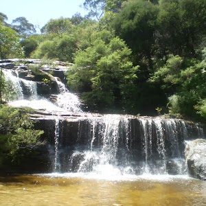
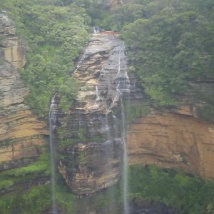
Weeping Rock
(0.66km) Weeping Rock waterfall → Int of Weeping Rock and Wentworth Falls Tracks
40 m
1 mins
0m
-8m
Moderate track
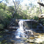
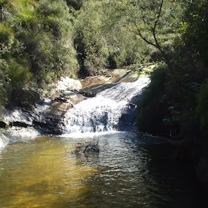
(0.7km) Int of Weeping Rock and Wentworth Falls Tracks → Top of Wentworth Falls
60 m
1 mins
3m
-2m
Moderate track
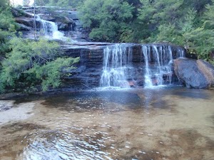
Queen’s Cascades
(0.7km) Int of Weeping Rock and Wentworth Falls Tracks → Int of Undercliff and Fletchers Lookout Tracks
30 m
1 mins
1m
0m
Easy track
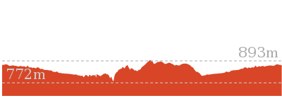
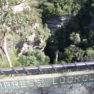
(0.74km) Int of Undercliff and Fletchers Lookout Tracks → Fletchers Lookout
20 m
1 mins
0m
-7m
Moderate track
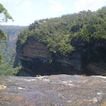
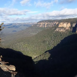
Fletchers Lookout

(0.74km) Int of Undercliff and Fletchers Lookout Tracks → Wentworth Falls Picnic Area Entrance
640 m
16 mins
81m
-5m
Moderate track
Veer left: From the intersection, this walk follows the ‘Wentworth Falls Picnic Area’ sign up the log steps. The track soon passes some views to the left and then comes to an intersection (at a sharp right-hand bend), with a track closed at the time of writing. Here there is a sign pointing back to ‘Wentworth Falls – National Pass’.
Turn right: From the intersection, this walk heads up the steps, following ‘Wentworth Falls Picnic Area’ signs. The walk soon heads through a sharp left bend, then continues up the hill, passing several information signs. At the top of the steps, the track breaks out to Wentworth Falls Lookout on Sir H. Burrell Drive.
Turn right: From the lookout, this walk crosses Sir H Burrell Dr and heads straight up the log steps. The track soon starts to flatten out but continues gently uphill. The track then opens up to a clearing and an old picnic shelter at the intersection of Falls Rd and Burrell Dr, Wentworth Falls. This is just at the entrance to Wentworth Falls Lookout Picnic Area.
Veer left: From the main entrance to Wentworth Falls Picnic Area (at the intersection of Falls Rd and Sir H Burrell Dr), this walk follows the small ‘Pedestrian access to picnic area’ sign (keeping the road up to the right). The track soon passes a sandstone pillar marking an old lookout (still has some views). The track continues down the hill to open up into the Wentworth Falls Picnic Area.
Maps for the The Weeping Rock and Fletchers Lookout Tracks walk
You can download the PDF for this walk to print a map.These maps below cover the walk and the wider area around the walk, they are worth carrying for safety reasons.
| Katoomba | 1:25 000 Map Series | 89301S KATOOMBA | NSW-89301S |
| Katoomba | 1:100 000 Map Series | 8930 KATOOMBA | 8930 |
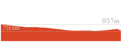
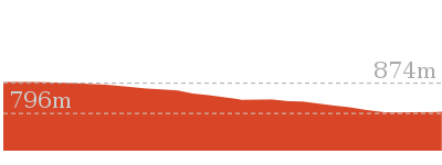
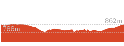
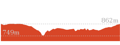
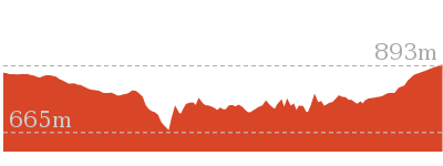
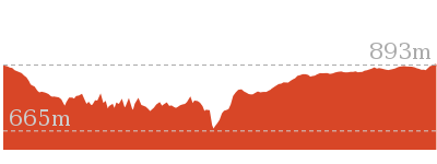
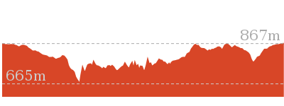
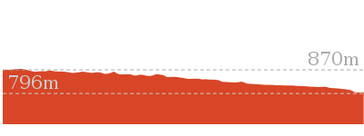
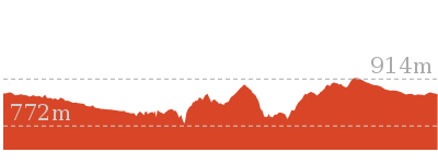
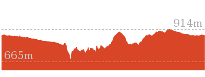
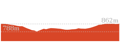
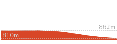
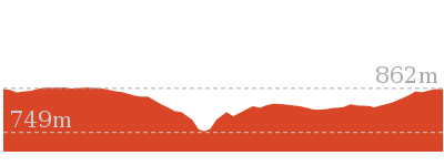
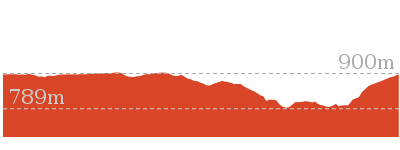
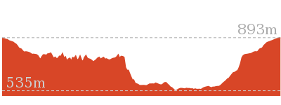
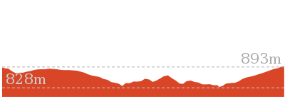
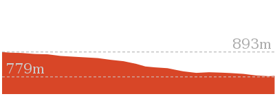
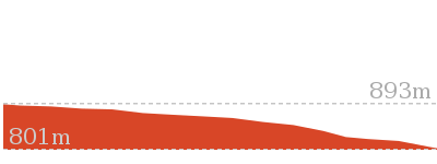
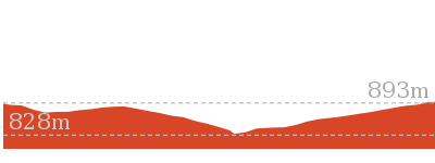
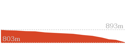
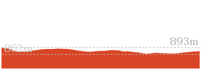
Cross sectional view of the The Weeping Rock and Fletchers Lookout Tracks bushwalking track
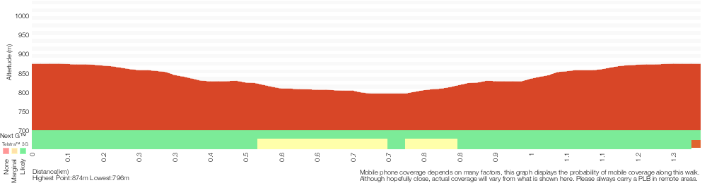
Analysis and summary of the altitude variation on the The Weeping Rock and Fletchers Lookout Tracks
Overview of this walks grade – based on the AS 2156.1 – 2001
Under this standard, a walk is graded based on the most difficult section of the walk.
| Length | 1.4 km | ||
| Time | 45 mins | ||
| . | |||
| Grade 3/6 Moderate track |
AS 2156.1 | Gradient | Short steep hills (3/6) |
| Quality of track | Formed track, with some branches and other obstacles (3/6) | ||
| Signs | Clearly signposted (1/6) | ||
| Experience Required | Some bushwalking experience recommended (3/6) | ||
| Weather | Storms may impact on navigation and safety (3/6) | ||
| Infrastructure | Limited facilities, not all cliffs are fenced (3/6) |
Some more details of this walks Grading
Here is a bit more details explaining grading looking at sections of the walk
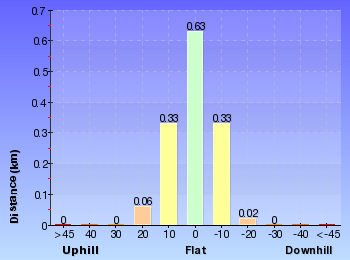
Gradient
Around 1km of this walk has gentle hills with occasional steps, whilst the remaining 340m has short steep hills.
Quality of track
Around 1.3km of this walk follows a clear and well formed track or trail, whilst the remaining 75m follows a formed track, with some branches and other obstacles.
Signs
This whole walk, 1.4km is clearly signposted.
Experience Required
Around 1.3km of this walk requires no previous bushwalking experience, whilst the remaining 75m requires some bushwalking experience.
weather
Around 1.3km of this walk is not usually affected by severe weather events (that would unexpectedly impact safety and navigation), whilst the remaining 75m is affected by storms that may impact your navigation and safety.
Infrastructure
Around 1.3km of this walk is close to useful facilities (such as fenced cliffs and seats), whilst the remaining 55m has limited facilities (such as not all cliffs fenced).
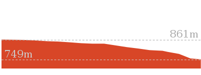
Similar walks
1.3 km Return
1 Hr
Moderate track
1.5 km Return
45 mins
Moderate track
2 km Circuit
1 hr 30 mins
Moderate track

2.2 km Circuit
1 hr 30 mins
Hard track
3.6 km One way
3 hrs
Hard track
4 km Circuit
2 hrs
Moderate track
4.6 km Circuit
3 hrs 30 mins
Hard track
5 km Circuit
4 hrs
Hard track
5.1 km Circuit
4 hrs
Hard track
5.6 km Return
2 hrs
Moderate track
8.6 km Circuit
5 hrs
Hard track

8.9 km Circuit
4 hrs 30 mins
Hard track
9.4 km Circuit
4 hrs
Moderate track
9.5 km Circuit
5 hrs 30 mins
Hard track
10.2 km Circuit
6 hrs
Hard track

29.2 km One way
2 Days
Experienced only

29.3 km One way
3 Days
Experienced only

Other Nearby walks
1.3 km Circuit
45 mins
Moderate track

926 m Return
45 mins
Hard track
746 m Return
45 mins
Moderate track
1.7 km Circuit
1 Hr
Hard track
3.1 km Circuit
2 hrs
Hard track
4.8 km Circuit
4 hrs
Hard track
1.9 km Circuit
1 Hr
Moderate track
1.1 km Return
1 Hr
Hard track
762 m Return
30 mins
Moderate track
950 m Circuit
30 mins
Moderate track
696 m Return
30 mins
Moderate track
1.1 km One way
30 mins
Moderate track
Plan your trip to and from the walk here
The The Weeping Rock and Fletchers Lookout Tracks walk starts and ends at the Wentworth Falls Picnic Area Entrance (gps: -33.724905, 150.37)Your main transport option to Wentworth Falls Picnic Area Entrance is by;
(get details)


Short URL = http://wild.tl/twraflt
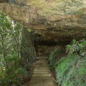
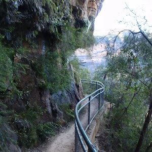
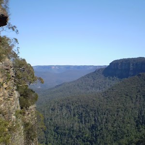
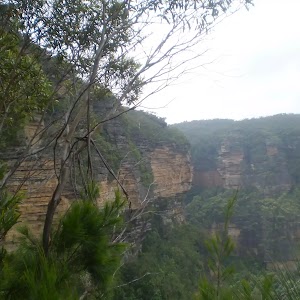
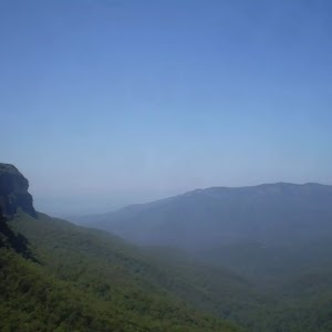
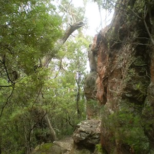
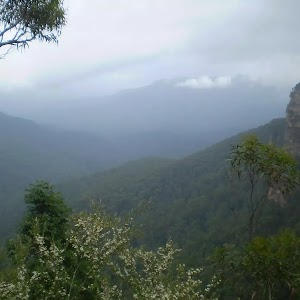
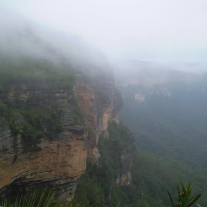
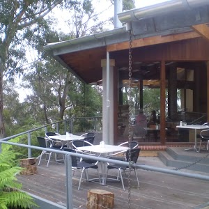
Gallery images
There are other downloads I am still working on.
You will probably need to login to access these — still all free.
* KML (google earth file)
* GPX (GPS file)
Special Maps/ brochures
* A3 topo maps
* PDF with Lands Topo map base
* PDF with arial image (and map overlay)
I wanted to get the main site live first, this extra stuff will come in time.
Happy walking
Matt 🙂
Comments