Wentworth Falls Station Loop


5 hrs 30 mins

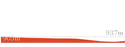
1030 m
Hard track
Closed:


(0km) Wentworth Falls Railway Station → Wilson Park

490 m
9 mins
13m
-15m
Very easy
(0.49km) Wilson Park → Int of Charles Darwin and Parkes St Tracks
540 m
12 mins
20m
-33m
Easy track
Continue straight: From the intersection, this walk passes the blue sign (on the right) and turns right down the steps to immediately come to an intersection just before the bridge (and a ‘Charles Darwin Walk’ sign).
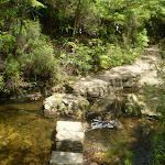
Turn left: From the intersection, this walk follows ‘Charles Darwin walk’ sign downstream, keeping the creek on the right. The track meanders alongside the creek over some timber platforms and through a lovely Banksia grove. Soon the track heads under a pipe bridge and comes to a clearing and intersection.
(1.03km) Int of Charles Darwin and Parkes St Tracks → Int of Charles Darwin and Fletcher St Tracks
840 m
17 mins
22m
-44m
Easy track
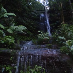
(1.87km) Int of Charles Darwin and Fletcher St Tracks → Weeping Rock waterfall
820 m
14 mins
3m
-26m
Moderate track
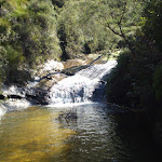
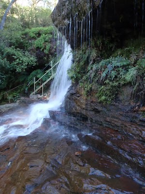
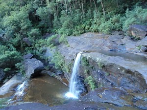
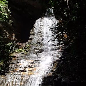
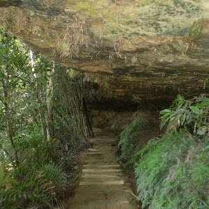
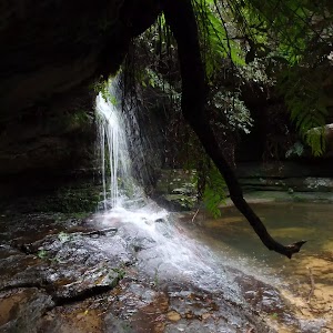
Veer left: From the intersection, this walk heads down the steps following the ‘Weeping Rock Circuit’ sign to the creek a short distance away. Soon the track comes beside Jamison Creek, a lovely flat section of the creek on top of the waterfall. The track continues downstream and across a slippery rockshelf and down a staircase beside the falls. At the bottom of the stairs is another slippery rock platform and a pool at the bottom of Weeping Rock waterfall.
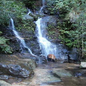
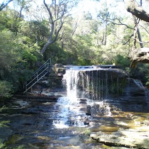
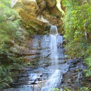
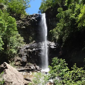
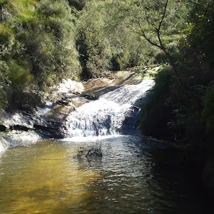
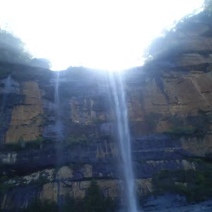
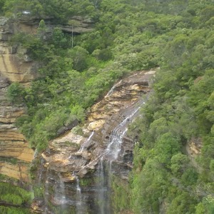
Weeping Rock
(2.69km) Weeping Rock waterfall → Int of Weeping Rock and Wentworth Falls Tracks
40 m
1 mins
0m
-8m
Moderate track
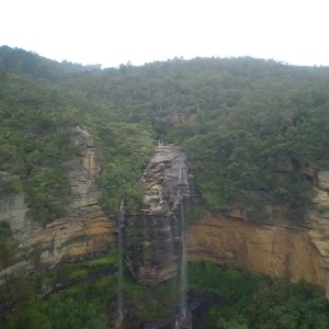
(2.73km) Int of Weeping Rock and Wentworth Falls Tracks → Top of Wentworth Falls
60 m
1 mins
3m
-2m
Moderate track
Queen’s Cascades
(2.79km) Top of Wentworth Falls → Rocket Point Creek Intersection
30 m
1 mins
2m
-6m
Moderate track
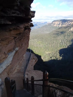
Grand Stairway
(2.81km) Rocket Point Creek Intersection → Middle Wentworth Falls
330 m
16 mins
36m
-98m
Hard track
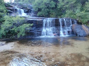
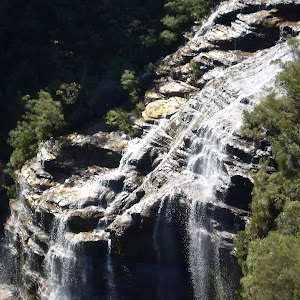
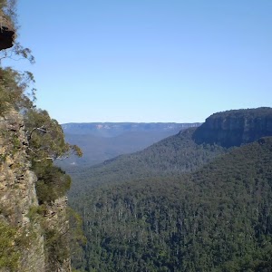
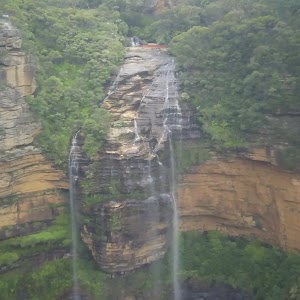
Middle of Wentworth Falls
(3.14km) Middle Wentworth Falls → Top of the Slack Stairs
270 m
19 mins
117m
-88m
Moderate track
(3.41km) Top of the Slack Stairs → Int of Valley of the Waters and National Pass Tracks
1.5 km
1 hr 23 mins
410m
-411m
Moderate track
(4.86km) Int of Valley of the Waters and National Pass Tracks → Lodore Falls
20 m
1 mins
14m
0m
Moderate track
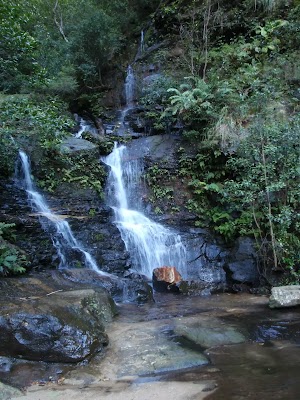
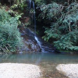
Lodore Falls
(4.88km) Lodore Falls → Empress Falls Crossing
70 m
2 mins
9m
0m
Hard track
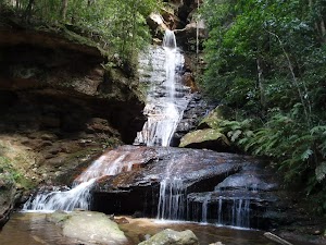
Empress Falls
(4.95km) Empress Falls Crossing → Int of Valley of the Waters and Nature Tracks
90 m
2 mins
14m
-4m
Moderate track
(5.04km) Int of Valley of the Waters and Nature Tracks → Empress Lookout
90 m
4 mins
20m
-12m
Hard track
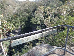
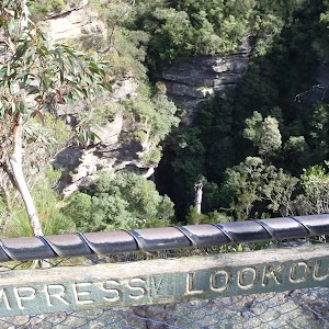
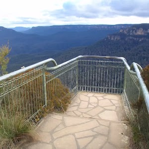
Empress Lookout
(5.13km) Empress Lookout → Int of Valley of the Waters and Queen Victoria Tracks
60 m
2 mins
18m
0m
Easy track
(5.19km) Int of Valley of the Waters and Queen Victoria Tracks → Queen Victoria Lookout
20 m
1 mins
0m
-17m
Easy track
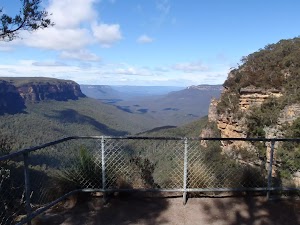
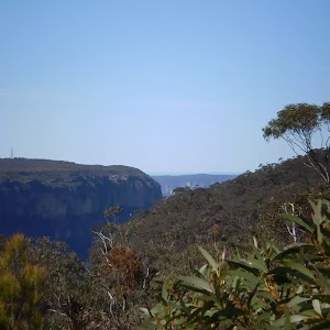
Queen Victoria Lookout
(5.19km) Int of Valley of the Waters and Queen Victoria Tracks → Conservation Hut
320 m
8 mins
75m
-2m
Moderate track
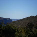
Continue straight: From the intersection, this walk heads up the timber and dirt steps, away from the valley views. The track passes a few faint tracks (on the right, that lead to an unfenced view point). The track soon comes to a signposted intersection with the ‘Overcliff Track’.
Continue straight: From the intersection, this walk follows the ‘National Pass – Tea Rooms’ sign up the steps, with the handrail on the left. After a short time, the track passes a couple of faint tracks (on the right, leading to an old picnic area). Heading up the main steps, the walk passes another handrail (and signs) then an information sign, before coming to a three-way intersection with the ‘Shortcut Track’.
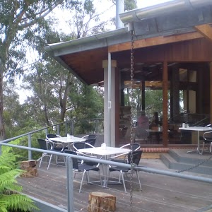
Continue straight: From the intersection, this walk heads up the steps towards the building. The walk passes a couple of picnic shelters (on the right) before coming to the road and the front of the ‘Conservation Hut’.
Conservation Hut

(5.51km) Conservation Hut → Int of Valley of the Waters and Nature Tracks
470 m
14 mins
14m
-113m
Hard track
Continue straight: From the intersection, this walk follows the ‘Valley of the Waters’ sign down the steps, passing an information sign. After the handrail and more signs, the track passes a couple of faint tracks (on the left, leading to an old picnic area). Further down the steps, the walk comes the end of another handrail and a three-way intersection (signposted ‘Overcliff Track’ and ‘National Pass’).
Continue straight: From the intersection, this walk follows the ‘National Pass – Valley of the Waters’ sign down the timber steps. The track passes a few faint tracks (on the left, that lead to an unfenced view point). The walk continues down the steps, soon coming to an unsignposted intersection with the Lyrebird Cliff track (on a small sandstone rock platform).
Continue straight: From the intersection, this walk heads down the wooden steps to almost immediately come to the signposted intersection with ‘Queen Victoria Lookout’ track.
Veer right: From the intersection, this walk heads down the steps away from ‘Queen Victoria Lookout’ keeping the rock face to the right. The track soon passes under a sandstone overhang and then down more steps to come to the fenced and signposted ‘Empress Lookout’.
Turn right: From Empress Lookout, this walk heads down the wooden steps, keeping the handrail and valley to the left. Soon the walk heads downs a series of steep metal staircases that zigzag down the hill. At the bottom of the staircases, the walk follows the handrail through a long sandstone overhang. The track then heads down some steps to come to an intersection with the ‘Nature Track’ and a sign pointing back to ‘National Pass – Tea Rooms’.
(5.99km) Int of Valley of the Waters and Nature Tracks → Lillians Glen
430 m
13 mins
42m
-43m
Moderate track
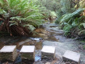
Continue straight: From post number 5 at Lillian’s Bridge, this walk heads up the stairs away from the handrail, keeping the bridge and valley to the left. The track makes its way around the hill, passing a few handrails before heading down to some stepping stones across the creek. (This is a nice but slippery spot to enjoy, with a small waterfall to the right). After crossing the stepping stones, the track heads over a small rise to come back down and cross the creek again, on another set of stepping stones. This is signposted ‘Lillians Glen’.
Lillian’s Glen
(6.42km) Lillian’s Glen → Edinburgh Castle Rock
400 m
13 mins
88m
-21m
Moderate track
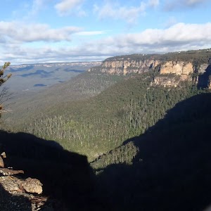
Turn right: From the intersection, this walk heads past the sign saying ‘Edinburgh Castle Rock’ towards the unfenced rock and great views – this is Edinburgh Castle Rock.
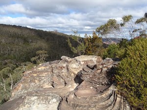
Edinburgh Castle Rock
(6.82km) Edinburgh Castle Rock → Int of Nature and Edinburgh Castle Rock Tracks
10 m
1 mins
6m
-2m
Moderate track
(6.83km) Int of Nature and Edinburgh Castle Rock Tracks → Int of Nature Track and West St Trail
540 m
15 mins
54m
-18m
Moderate track
Continue straight: From the intersection, this walk follows the ‘Valley of the Waters Picnic Area’ sign up the steps. The track soon flattens out and heads through the bush for a little while until coming to a ‘T’ intersection with the wide West St trail and a ‘Nature Track Circuit’ sign.
(7.37km) Int of Nature Track and West St Servicetrail → Int of Armstrong St Servicetrail and Nature Track
350 m
8 mins
17m
-17m
Easy track
(7.71km) Int of Armstrong St Servicetrail and Nature Track → Corner of Armstrong St and Valley Rd
100 m
2 mins
15m
0m
Moderate track
(7.82km) Corner of Armstrong St and Valley Rd → Wilson Park
1.2 km
21 mins
3m
-55m
Easy track
(9.01km) Wilson Park → Wentworth Falls Railway Station
490 m
9 mins
15m
-13m
Very easy
Maps for the Wentworth Falls Station Loop walk
You can download the PDF for this walk to print a map.These maps below cover the walk and the wider area around the walk, they are worth carrying for safety reasons.
| Katoomba | 1:25 000 Map Series | 89301S KATOOMBA | NSW-89301S |
| Katoomba | 1:100 000 Map Series | 8930 KATOOMBA | 8930 |
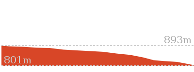
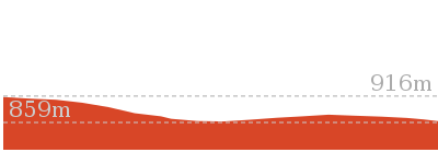
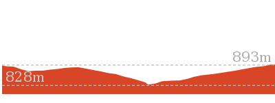
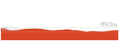
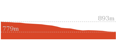
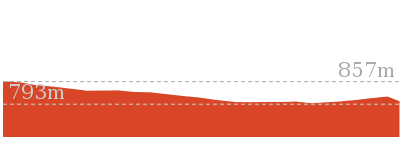
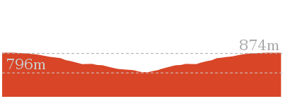
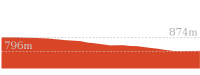
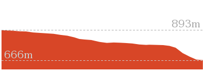
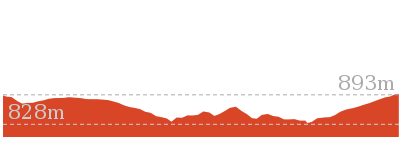
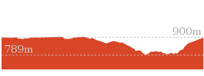
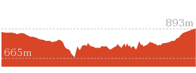
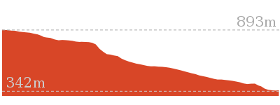
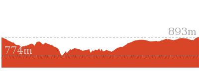
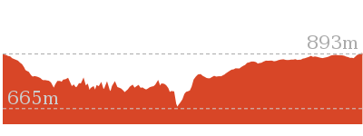
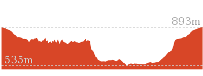
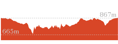
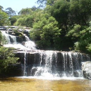
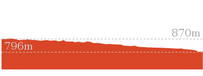
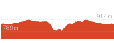
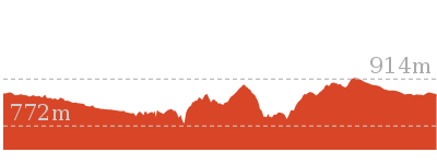
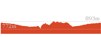
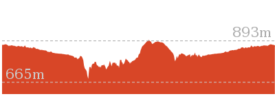
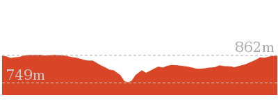
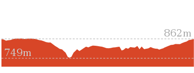
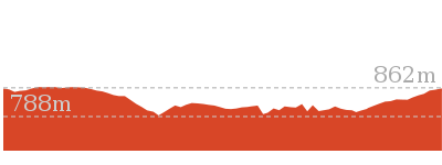
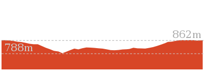
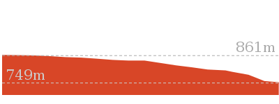
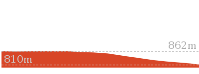
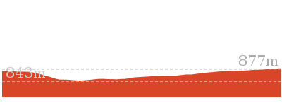
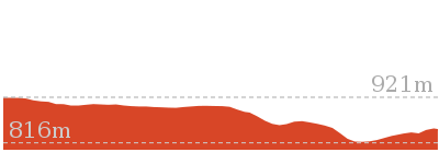
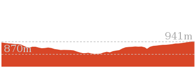
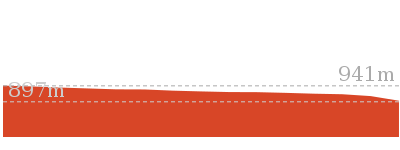
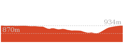
Cross sectional view of the Wentworth Falls Station Loop bushwalking track
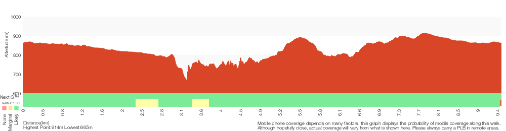
Analysis and summary of the altitude variation on the Wentworth Falls Station Loop
Overview of this walks grade – based on the AS 2156.1 – 2001
Under this standard, a walk is graded based on the most difficult section of the walk.
| Length | 9.5 km | ||
| Time | 5 hrs 30 mins | ||
| . | |||
| Grade 4/6 Hard track |
AS 2156.1 | Gradient | Very steep (4/6) |
| Quality of track | Formed track, with some branches and other obstacles (3/6) | ||
| Signs | Directional signs along the way (3/6) | ||
| Experience Required | Some bushwalking experience recommended (3/6) | ||
| Weather | Storms may impact on navigation and safety (3/6) | ||
| Infrastructure | Limited facilities, not all cliffs are fenced (3/6) |
Some more details of this walks Grading
Here is a bit more details explaining grading looking at sections of the walk
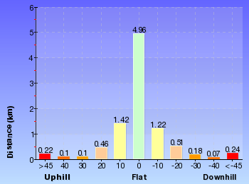
Gradient
3.5km of this walk has gentle hills with occasional steps and another 3.2km has short steep hills. Whilst another 2.2km is flat with no steps and the remaining 580m is very steep.
Quality of track
4.2km of this walk follows a smooth and hardened path and another 2.9km follows a clear and well formed track or trail. The remaining (2.4km) follows a formed track, with some branches and other obstacles.
Signs
Around 7km of this walk is clearly signposted, whilst the remaining 2.9km has directional signs at most intersection.
Experience Required
Around 6km of this walk requires no previous bushwalking experience, whilst the remaining 3.4km requires some bushwalking experience.
weather
Around 7km of this walk is not usually affected by severe weather events (that would unexpectedly impact safety and navigation), whilst the remaining 2.7km is affected by storms that may impact your navigation and safety.
Infrastructure
Around 8km of this walk is close to useful facilities (such as fenced cliffs and seats), whilst the remaining 1.3km has limited facilities (such as not all cliffs fenced).
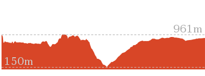
Similar walks
696 m Return
30 mins
Moderate track
762 m Return
30 mins
Moderate track
880 m Return
30 mins
Moderate track
950 m Circuit
30 mins
Moderate track
1.1 km One way
30 mins
Moderate track
1.1 km Return
1 Hr
Hard track
1.3 km Return
1 Hr
Moderate track
1.4 km Circuit
45 mins
Moderate track
1.5 km Return
45 mins
Moderate track
1.5 km Return
1 hr 30 mins
Hard track

1.6 km Return
1 Hr
Moderate track
1.9 km Circuit
1 Hr
Moderate track
3.1 km Circuit
2 hrs
Hard track
3.6 km One way
3 hrs
Hard track
3.8 km Return
4 hrs
Experienced only

4 km Circuit
2 hrs
Moderate track
4.6 km Circuit
3 hrs 30 mins
Hard track
4.8 km Circuit
4 hrs
Hard track
5 km Circuit
4 hrs
Hard track
5.1 km Circuit
4 hrs
Hard track
5.6 km Return
2 hrs
Moderate track
6.7 km Circuit
3 hrs
Hard track
8.6 km Circuit
5 hrs
Hard track

8.9 km Circuit
4 hrs 30 mins
Hard track
9.4 km Circuit
4 hrs
Moderate track
10.2 km Circuit
6 hrs
Hard track

29.2 km One way
2 Days
Experienced only

29.3 km One way
3 Days
Experienced only

Other Nearby walks
1.7 km Circuit
1 Hr
Hard track
2.2 km Circuit
1 hr 30 mins
Hard track
2 km Circuit
1 hr 30 mins
Moderate track
1.3 km Circuit
45 mins
Moderate track

926 m Return
45 mins
Hard track
746 m Return
45 mins
Moderate track
1.6 km One way
45 mins
Easy track

2.9 km Return
1 hr 30 mins
Moderate track
538 m Return
30 mins
Moderate track
1.6 km One way
1 Hr
Moderate track
752 m Return
30 mins
Moderate track
1.4 km Circuit
1 Hr
Moderate track
Plan your trip to and from the walk here
The Wentworth Falls Station Loop walk starts and ends at the Wentworth Falls Railway Station (gps: -33.709737, 150.37644)Your transport options to Wentworth Falls Railway Station are by;
(get details)


Short URL = http://wild.tl/wfsl
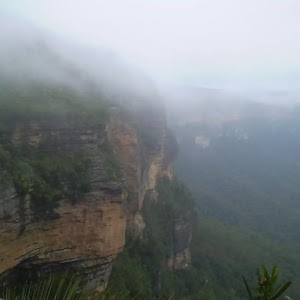
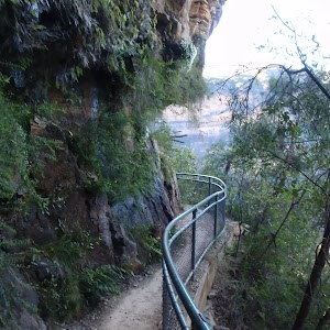
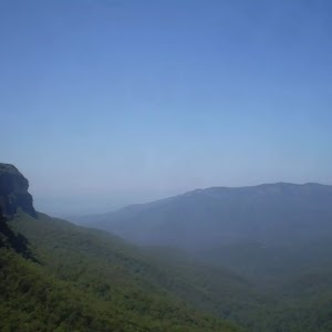
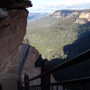
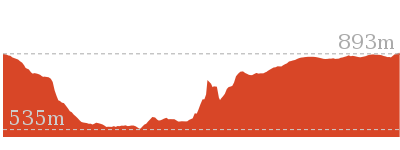
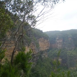
Gallery images
There are other downloads I am still working on.
You will probably need to login to access these — still all free.
* KML (google earth file)
* GPX (GPS file)
Special Maps/ brochures
* A3 topo maps
* PDF with Lands Topo map base
* PDF with arial image (and map overlay)
I wanted to get the main site live first, this extra stuff will come in time.
Happy walking
Matt 🙂
Comments