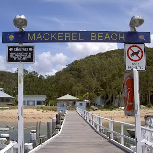
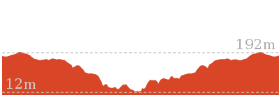
Mackerel Beach, West Head Loop


5 hrs

422 m
Hard track


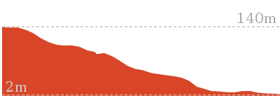
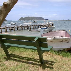
(0km) Palm Beach → Mackerel Beach Wharf

1.9 km
28 mins
2m
0m
Easy track
(1.89km) Mackerel Beach Wharf → Int. Resolute Bch Trk and Mackerel Bch Trk
1 km
25 mins
90m
-53m
Moderate track
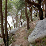
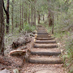
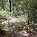
Continue straight: From the palm trees and boulder painted with a black arrow, this walk heads up the hill into the bush, away from the beach. The track climbs to pass a ‘Ku-ring-gai Chase National Park’ sign before meandering along the hillside in an easterly direction, up the hill for approximately 400m. The track then rounds the headland to lead beneath a rocky headland for some time to a signposted intersection.
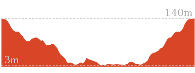
(2.9km) Int. Resolute Bch Trk and Mackerel Bch Trk → Cave
140 m
5 mins
47m
-2m
Hard track
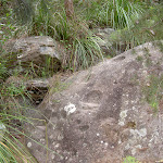
Veer right: From the intersection, this walk heads towards the rock formations, following the hillside. The track then enters an overhang of a cave. At the end of this side trip, retrace your steps back to the main walk then Turn left .
(2.9km) Int. Resolute Bch Trk and Mackerel Bch Trk → Int. Resolute AND West Head Beach Tracks
40 m
1 mins
1m
-6m
Hard track
(2.94km) Int. Resolute AND West Head Beach Tracks → Resolute Beach
100 m
3 mins
0m
-25m
Hard track
(2.94km) Int. Resolute Bch Trk and Mackerel Bch Trk → Int. Resolute AND West Head Beach Tracks
630 m
20 mins
76m
-66m
Hard track
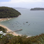
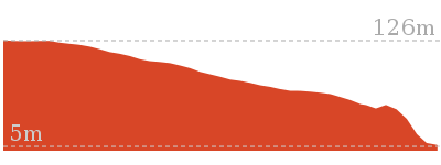
(3.57km) Int. West Head Beach and West Head Lookout → West Head Beach
100 m
3 mins
0m
-33m
Hard track
(3.57km) Int. West Head Beach and West Head Lookout → West Head Lookout
350 m
13 mins
76m
-5m
Hard track
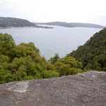
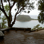
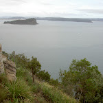
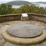
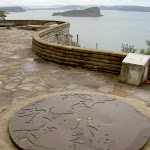
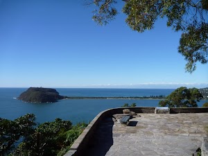
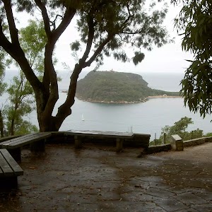
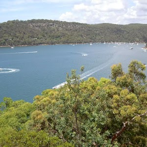
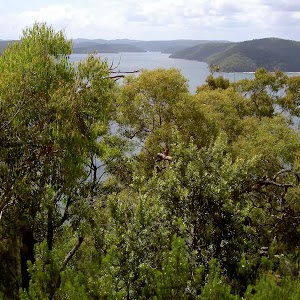
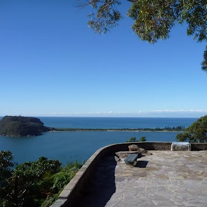
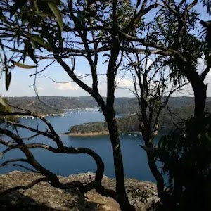
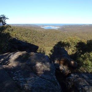
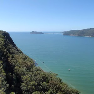
West Head Lookout


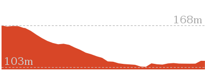
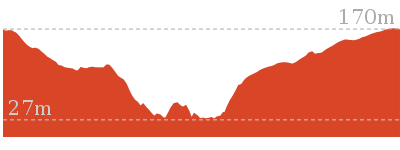
(3.92km) West Head Lookout → Int. West Head Lookout Trk and Red Hands Cave Trk
820 m
20 mins
70m
-19m
Moderate track
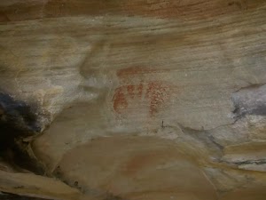
(4.74km) Int. West Head Lookout Trk and Red Hands Cave Trk → Red Hands Cave
20 m
0m
-1m
Moderate track
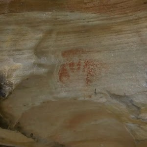
Red Hands Cave
(4.74km) Int. West Head Lookout Trk and Red Hands Cave Trk → Resolute Picnic Area
130 m
3 mins
6m
-1m
Moderate track
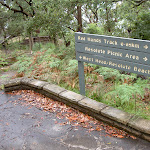
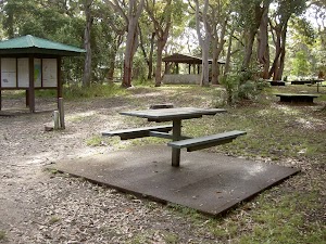
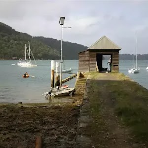
Resolute Picnic Area
(4.87km) Resolute Picnic Area → Flint and Steel carpark
1.1 km
24 mins
28m
-56m
Moderate track
Continue straight: From the intersection, this walk heads up the hill towards the ‘Crest’ road sign. The walk continues down the steep hill to the signposted intersection of ‘Flint and Steel’ car park.
(5.97km) Flint and Steel carpark → Flint and Steel beach
1.1 km
29 mins
36m
-173m
Moderate track
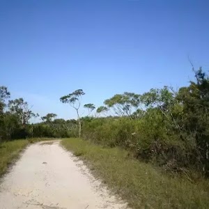
Veer right: From intersection, this walk follows the ‘Flint and Steel Beach 700m’ arrow through a palm grove, along the ridge, with views across Hawkesbury River to Lion Island. The track runs parallel to rock formations on the left before winding its way through the trees and down the boardwalk, with the large rocks to the left. Soon the track heads through some pine trees and comes to an intersection of a bush track, near some large boulders on the left.
Continue straight: From the intersection, this walk follows the track heading straight down the hill towards the beach, splitting for a about 10m before coming to a rock shelf above the waterline. From here, the track turns right and follows this rock shelf for about 20m, onto Flint and Steel Beach. At the end of this side trip, retrace your steps back to the main walk then Turn sharp right.
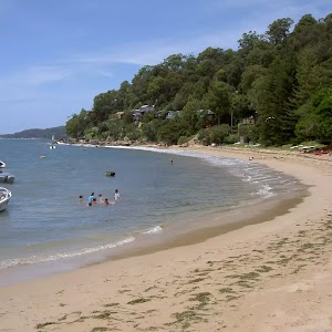
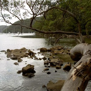
Flint and Steel Beach
(5.97km) Flint and Steel carpark → Int. Basin Trk and West Head Rd
1.5 km
27 mins
36m
-25m
Moderate track
Continue straight: From the intersection, this walk heads south along West Head Road, keeping the metal fence poles behind and to the right. The track continues to wind down the road for approximately 700m to meet the Basin car park and intersection.
(7.44km) Int. Basin Trk and West Head Rd → Int. Basin Trk and Aboriginal Engraving Trk Entry
360 m
7 mins
13m
-3m
Moderate track
(7.81km) Int. Basin Trk and Aboriginal Engraving Trk Entry → Int. Basin Trk and Aboriginal Engraving Trk Exit
110 m
2 mins
3m
-1m
Easy track
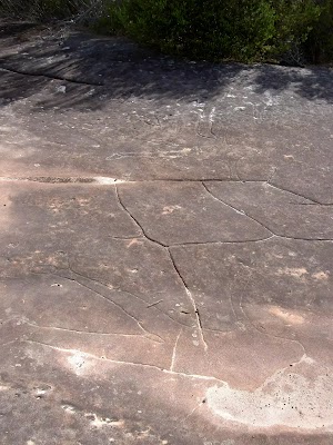
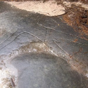
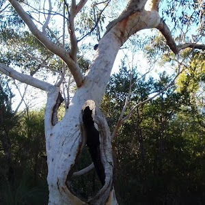
The Basin Track Aboriginal Engravings
(7.81km) Int. Basin Trk and Aboriginal Engraving Trk Entry → Mackerel Trk Clearing
1.8 km
33 mins
14m
-94m
Moderate track
Continue straight: From the intersection, the walk winds gently uphill along the management trail, keeping the engravings track initially on the right. The management trail then comes to the intersection with the signposted ‘Mackerel service trail’[10] on the left.
Veer left: From the intersection, this walk heads towards the sea, following the arrow sign ‘Mackerel Service Trail’. The track meanders down the wide spur for approximately 1km, to then lead along a narrower area of the spur and into a saddle. The track continues to undulate to a clearing with a view over Mackerel Beach and Pittwater Bay.
(9.59km) Mackerel Trk Clearing → Mackerel Beach Wharf
900 m
20 mins
12m
-94m
Hard track
Turn left: From the gate, this walk heads through the gate, then winds between and under the houses for approximately 200m, coming to a gate before the beach.
Veer left: From the gate, this walk heads onto the beach and continues for approximately 300m across the beach to the wharf in the middle of the beach.
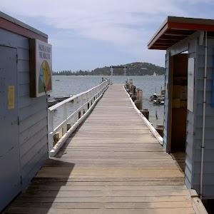
(10.49km) Mackerel Beach Wharf → Palm Beach
1.9 km
28 mins
0m
-2m
Easy track
Maps for the Mackerel Beach, West Head Loop walk
You can download the PDF for this walk to print a map.These maps below cover the walk and the wider area around the walk, they are worth carrying for safety reasons.
| Broken Bay | 1:25 000 Map Series | 91301N BROKEN BAY | NSW-91301N |
| Ku-ring-gai Chase National Park Tourist Map | 1:40 000 Map Series | CMA Ku-ring-gai Chase National Park Tourist Map | CMA Ku-ring-gai Chase National Park Tourist Map |
| Sydney | 1:100 000 Map Series | 9130 SYDNEY | 9130 |
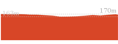
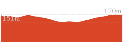
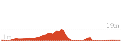
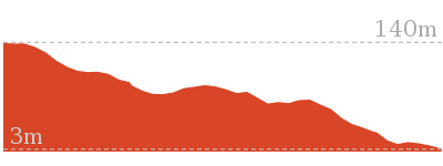
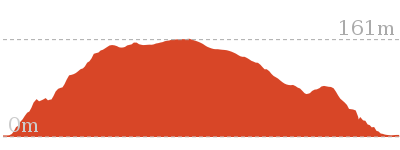
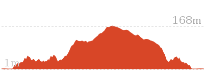
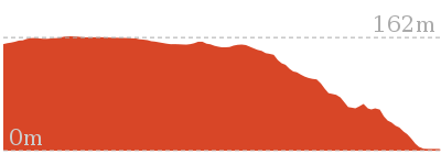
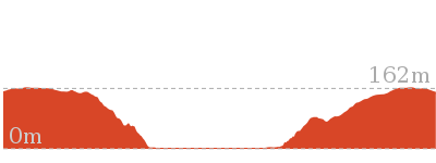
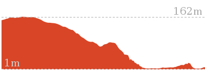
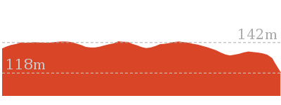
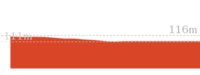
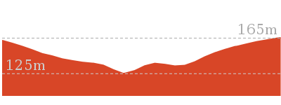
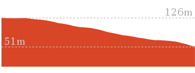
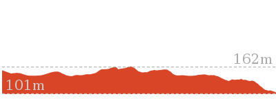
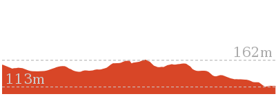
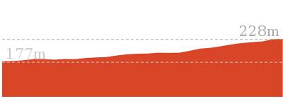
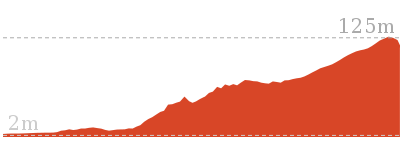
Cross sectional view of the Mackerel Beach, West Head Loop bushwalking track

Analysis and summary of the altitude variation on the Mackerel Beach, West Head Loop

Overview of this walks grade – based on the AS 2156.1 – 2001
Under this standard, a walk is graded based on the most difficult section of the walk.
| Length | 8.6 km | ||
| Time | 5 hrs | ||
| . | |||
| Grade 4/6 Hard track |
AS 2156.1 | Gradient | Very steep (4/6) |
| Quality of track | Rough track, where fallen trees and other obstacles are likely (4/6) | ||
| Signs | Minimal directional signs (4/6) | ||
| Experience Required | Some bushwalking experience recommended (3/6) | ||
| Weather | Weather generally has little impact on safety (1/6) | ||
| Infrastructure | Limited facilities (such as cliffs not fenced, significant creeks not bridged) (4/6) |
Some more details of this walks Grading
Here is a bit more details explaining grading looking at sections of the walk
Gradient
5km of this walk has gentle hills with occasional steps and another 4.1km is flat with no steps. Whilst another 2.6km has short steep hills and the remaining 630m is very steep.
Quality of track
7km of this walk follows a clear and well formed track or trail and another 2.6km follows a smooth and hardened path. Whilst another 1.5km follows a formed track, with some branches and other obstacles and the remaining 960m follows a rough track, where fallen trees and other obstacles are likely.
Signs
6km of this walk is clearly signposted and another 5km has directional signs at most intersection. The remaining (1.2km) has minimal directional signs.
Experience Required
Around 12km of this walk requires no previous bushwalking experience, whilst the remaining 850m requires some bushwalking experience.
weather
This whole walk, 12km is not usually affected by severe weather events (that would unexpectedly impact safety and navigation).
Infrastructure
8km of this walk is close to useful facilities (such as fenced cliffs and seats) and another 4.1km has limited facilities (such as not all cliffs fenced). The remaining (670m) has limited facilities (such as cliffs not fenced, significant creeks not bridged).
Similar walks
403 m Circuit
30 mins
Moderate track
1.1 km Circuit
45 mins
Moderate track
1.4 km Circuit
45 mins
Moderate track

1.9 km Return
1 Hr
Hard track
1.9 km Return
1 Hr
Moderate track

2.1 km Return
1 Hr
Moderate track

2.8 km Circuit
1 hr 30 mins
Very experienced only
3.5 km Circuit
1 hr 45 mins
Hard track
3.7 km Return
1 hr 30 mins
Hard track
4.5 km One way
1 hr 45 mins
Hard track
5.4 km Circuit
3 hrs
Hard track
5.6 km Return
2 hrs 30 mins
Moderate track
5.9 km Circuit
3 hrs
Hard track
8.2 km Return
3 hrs
Hard track
Other Nearby walks

2.3 km Return
1 hr 30 mins
Hard track
3 km Return
1 hr 15 mins
Moderate track
238 m Return
10 mins
Easy track
810 m Circuit
30 mins
Moderate track
2.2 km Return
1 hr 15 mins
Hard track
1.9 km Return
45 mins
Moderate track
7.6 km Return
3 hrs
Moderate track
6.8 km Return
2 hrs 30 mins
Moderate track
3.8 km Return
1 hr 30 mins
Moderate track
1.4 km Return
40 mins
Moderate track
8.4 km Circuit
4 hrs
Moderate track
5.1 km Return
2 hrs
Moderate track
Plan your trip to and from the walk here
The Mackerel Beach, West Head Loop walk starts and ends at the Palm Beach (gps: -33.595749, 151.31911)Your transport options to Palm Beach are by;
(get details)


Short URL = http://wild.tl/mbwhl
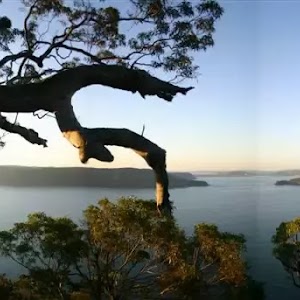
Gallery images
There are other downloads I am still working on.
You will probably need to login to access these — still all free.
* KML (google earth file)
* GPX (GPS file)
Special Maps/ brochures
* A3 topo maps
* PDF with Lands Topo map base
* PDF with arial image (and map overlay)
I wanted to get the main site live first, this extra stuff will come in time.
Happy walking
Matt 🙂
Comments