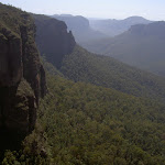
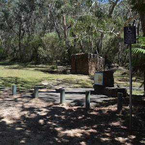
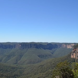
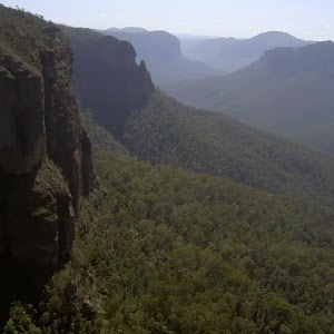
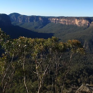
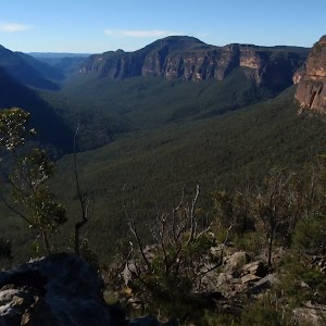
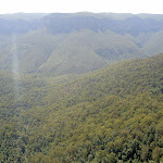
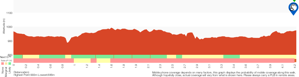
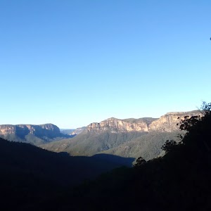
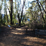
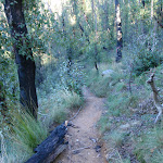
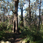
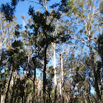
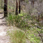
On this short and easy walk, you will explore two lookouts with stunning views down the Grose Valley. Starting from the car park, you really should make the short side trip through the stone arch to Govetts Leap Lookout. The main walk follows the well-formed footpath through the bush up to the less visited George Phillips Lookout. There are a pleasant stone shelter and picnic tables here. Around the car park are plenty of picnic facilities and a toilet block. A great walk giving you a sense of the scale of the breathtaking Grose Valley.
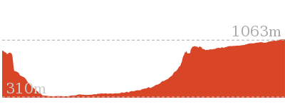
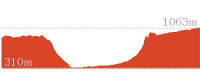
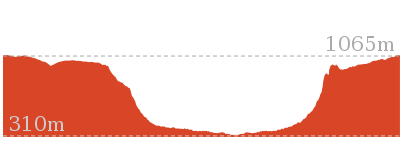
George Phillips Lookout walk
And Walk
George Phillips Lookout walk


30 mins
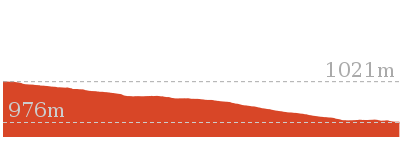
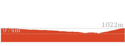
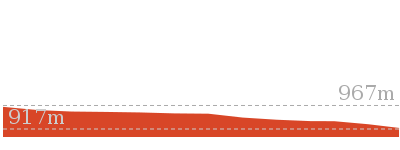
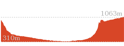
588 m Return

18 m
Very easy


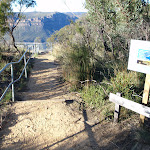
(0km) Govetts Leap Lookout Picnic Area → Govetts Leap Lookout

40 m
1 mins
0m
-7m
Very easy
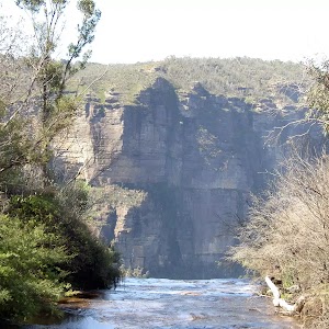
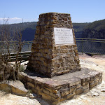
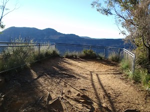
Govetts Leap Lookout

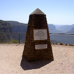
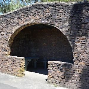
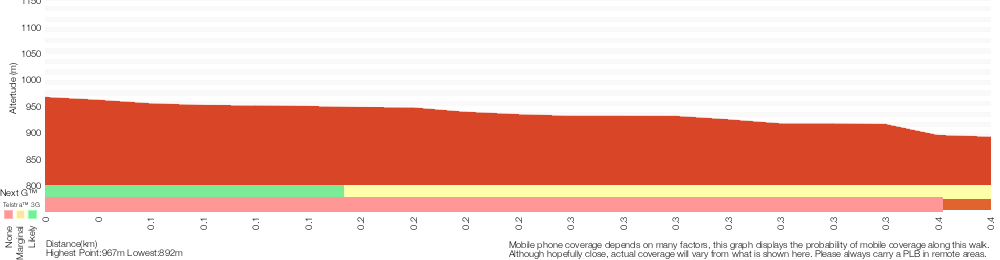
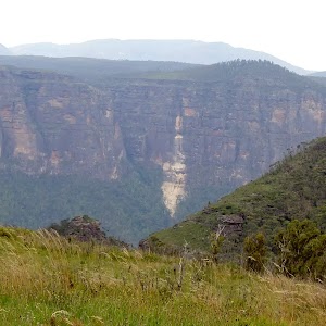
Govetts Leap Lookout is named after the first European man to have enjoyed this view, William Govett, as an assistant surveyor in June 1831. Govetts Leap Lookout offers wonderful views over the Grose Valley and the spectacular Bridal Falls. The word `leap` is an old Scottish word meaning waterfall. The lookout is easily accessed from the car park[9], there are also toilets[10]

and picnic shelters[11]

nearby.
(0km) Govetts Leap Lookout Picnic Area → George Phillips Lookout
290 m
6 mins
11m
-7m
Very easy
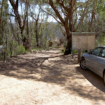
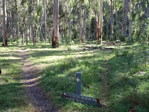
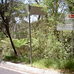
Turn right: From the large stone shelter[12]

at the edge of the turning circle (and car park)[13] at the end of Govetts Leap Rd, this walk heads for about 60m across the dirt/gravel[14] car park, away from the main cliff views, keeping the road to the left. The walk then heads between the timber bollards[15]

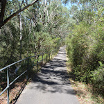
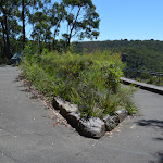
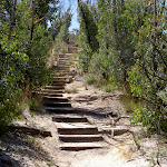
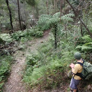
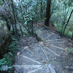
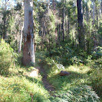
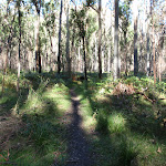
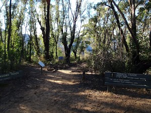
, to follow the ‘The Fairfax Heritage Trail’ asphalt path[16] and continues gently uphill for 180m to where path bends sharply left, then right. Here the walk continues along the path for another 25m to the signposted[17] ‘George Phillips Lookout’[18] (on your right).
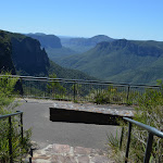
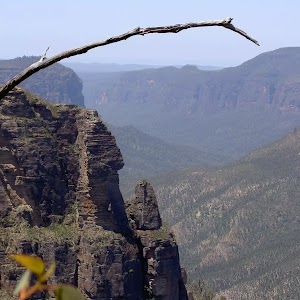
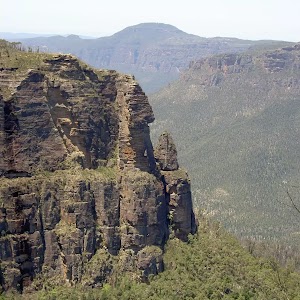
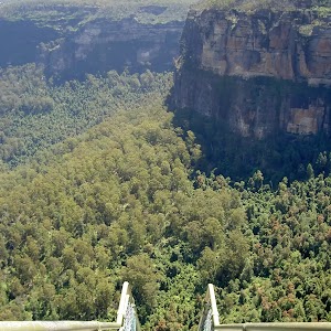
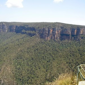
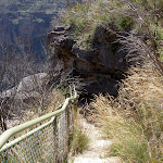
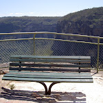
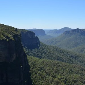
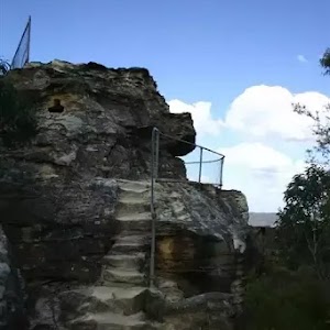
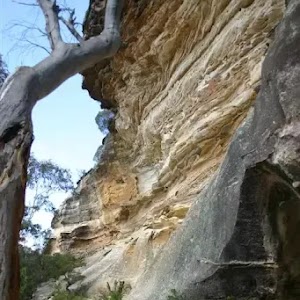
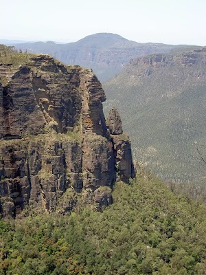
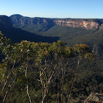
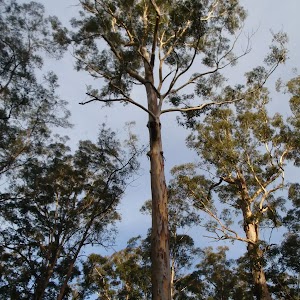
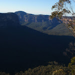
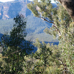
George Phillips Lookout
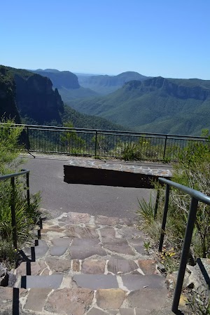
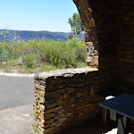
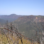
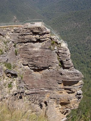
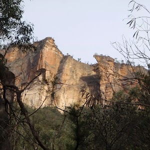
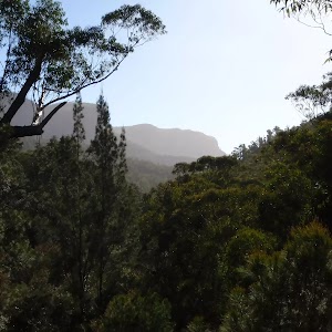
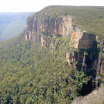
George Phillips Lookout, Blue Mountains National Park, provides stunning views east into the Grose Valley. The lookout offers views to Pulpit Rock, the horseshoe-shaped gorge and over the deep, green gorges of the Grose Valley to Mount Banks. The lookout is fenced and has a wheelchair accessible ramp. There are a series of picnic tables including a stone shelter

just behind the lookout.
Maps for the George Phillips Lookout walk walk
You can download the PDF for this walk to print a map.
These maps below cover the walk and the wider area around the walk, they are worth carrying for safety reasons.
| Katoomba | 1:25 000 Map Series | 89301S KATOOMBA | NSW-89301S |
| Katoomba | 1:100 000 Map Series | 8930 KATOOMBA | 8930 |
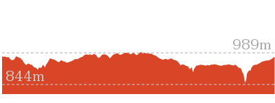
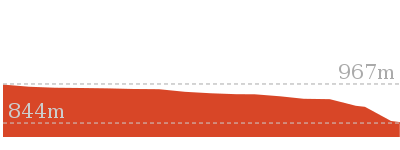
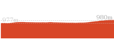
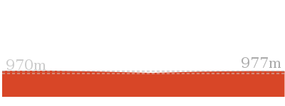
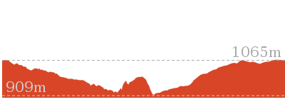
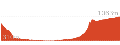
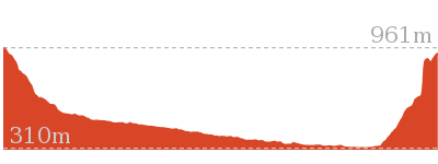
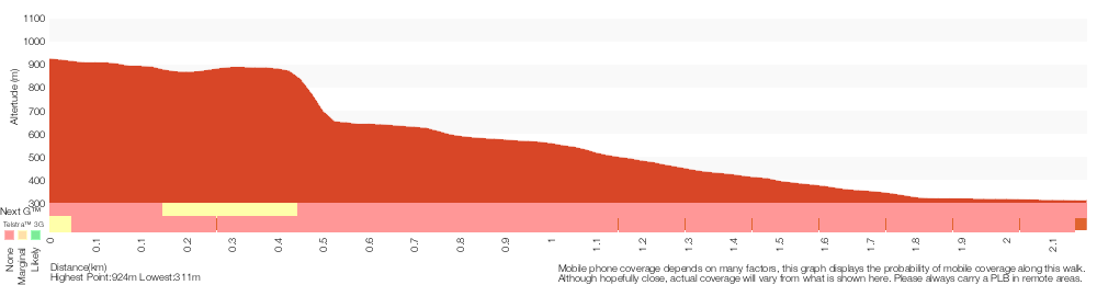
Cross sectional view of the George Phillips Lookout walk bushwalking track
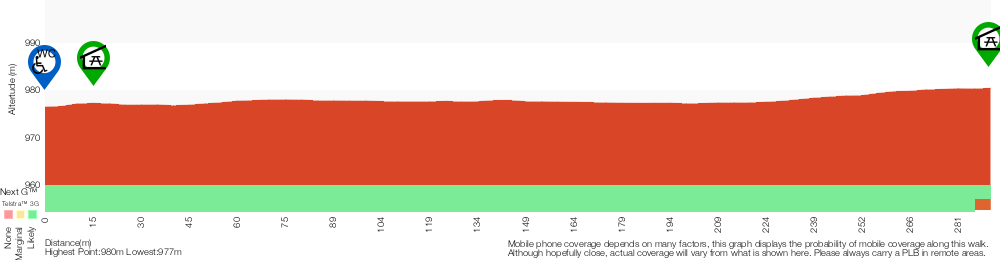
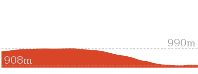
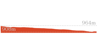
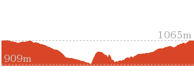
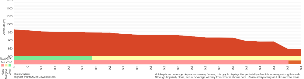
Analysis and summary of the altitude variation on the George Phillips Lookout walk
Accessibility summary information for the George Phillips Lookout walk
Parking: There are 0 designated accessible parking areas on this walk.
Toilets: There are 0 designated accessible toilets on this walk.
Seats: There are 1 places to sit on this walk.
Hazards: There are 2 specific noteable accessability related hazards on this walk.
Wheelchair Rough This walk leads through a gravel carpark for about 60m. The surface in unevean and erroded in places. The gravel is mostly compressed but the surface may soften after prolonged rain. Found about 30m into the walk.
Trip Hazard A 5 to 10cm step between carpark and track. Access is between bollards that are 110cm apart. Found about 70m into the walk.
Accessibility Details

Found 0m into this walk
Found 10m into this walk
Found 30m into this walk
Found 290m into this walk
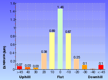
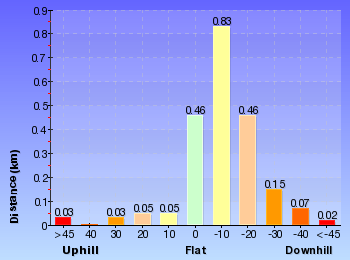
Overview of this walks grade – based on the AS 2156.1 – 2001
Under this standard, a walk is graded based on the most difficult section of the walk.
| Length | 588 m | ||
| Time | 30 mins | ||
| . | |||
| Grade 1/6 Very easy |
AS 2156.1 | Gradient | Flat, no steps (1/6) |
| Quality of track | Smooth and hardened path (1/6) | ||
| Signs | Clearly signposted (1/6) | ||
| Experience Required | No experience required (1/6) | ||
| Weather | Weather generally has little impact on safety (1/6) | ||
| Infrastructure | Generally useful facilities (such as fenced cliffs and seats) (1/6) |
Some more details of this walks Grading
Here is a bit more details explaining grading looking at sections of the walk
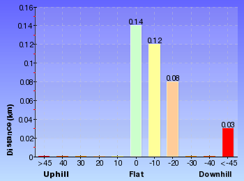
Gradient
This whole walk, 290m is flat with no steps.
Quality of track
This whole walk, 290m follows a smooth and hardened path.
Signs
This whole walk, 290m is clearly signposted.
Experience Required
This whole walk, 290m requires no previous bushwalking experience.
weather
This whole walk, 290m is not usually affected by severe weather events (that would unexpectedly impact safety and navigation).
Infrastructure
This whole walk, 290m is close to useful facilities (such as fenced cliffs and seats).
Similar walks
A list of walks that share part of the track with the George Phillips Lookout walk walk.
1.9 km One way
45 mins
Very easy
2.4 km Circuit
1 Hr
Very easy
Other Nearby walks
A list of walks that start near the George Phillips Lookout walk walk.
1.2 km Return
1 hr 45 mins
Hard track
3.8 km One way
2 hrs 30 mins
Hard track
3.2 km One way
1 hr 45 mins
Hard track
1.4 km Return
1 Hr
Hard track
13.6 km Circuit
8 hrs
Hard track
2.5 km Return
1 Hr
Hard track
4.2 km One way
2 hrs 30 mins
Hard track
816 m Return
45 mins
Hard track
748 m Return
30 mins
Moderate track
630 m Return
30 mins
Moderate track
6.6 km One way
4 hrs 15 mins
Hard track
8.7 km Circuit
3 hrs 30 mins
Hard track
Plan your trip to and from the walk here
The George Phillips Lookout walk walk starts and ends at the Govetts Leap Lookout Picnic Area (gps: -33.628268, 150.31109)
Your main transport option to Govetts Leap Lookout Picnic Area is by;
![]() Car. There is free parking available.
Car. There is free parking available.
(get details)


Short URL = http://wild.tl/gplw
Gallery images
There are other downloads I am still working on.
You will probably need to login to access these — still all free.
* KML (google earth file)
* GPX (GPS file)
Special Maps/ brochures
* A3 topo maps
* PDF with Lands Topo map base
* PDF with arial image (and map overlay)
I wanted to get the main site live first, this extra stuff will come in time.
Happy walking
Matt 🙂
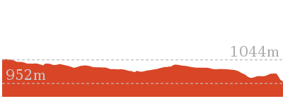
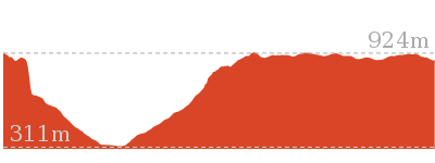
Pulpit Rock car park to Middle Lookout

30 mins
748 m Return
96 m
Moderate track


(0km) Pulpit Rock car park → Pulpit Rock middle Lookout
370 m
13 mins
10m
-86m
Moderate track
From the car park, the walk follows the sign to ‘Pulpit Rock Lookout’[1], down the stairs from the car park. The track continues down to a shelter and toilet, and then steeply heads down another flight of stairs, before flattening out and then descending more stairs to the signposted intersection.
Continue straight: From the intersection, this walk goes down the stairs, following the sign to ‘Pulpit Rock’. The track heads down the hill to a flat area with awesome views over the Grose Valley.
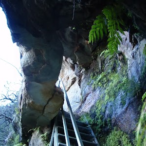
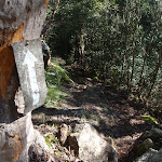
Veer left: From the upper lookout, this walk heads down the long set of stairs towards Pulpit Rock (a bench seat is visible from here). The walk passes a side path (which leads to a cave) and continues down to the bench seat in the middle of the platform.
Continue straight: From the intersection, this walk goes down the stairs, following the sign to ‘Pulpit Rock’. The track heads down the hill to a flat area with awesome views over the Grose Valley.
Veer left: From the upper lookout, this walk heads down the long set of stairs towards Pulpit Rock (a bench seat is visible from here). The walk passes a side path (which leads to a cave) and continues down to the bench seat in the middle of the platform.
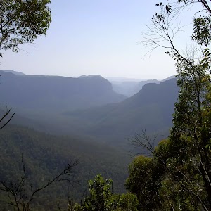
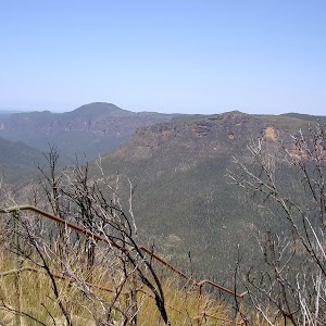
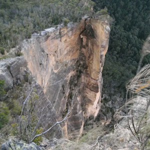
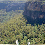
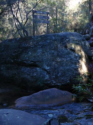
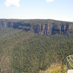
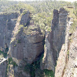
Pulpit Rock Lookout
Pulpit Rock Lookout, Blue Mountains National Park, looks over the Grose Valley and back towards Blackheath, with Bridal Veil Falls and the Govetts Leap cliff edge in view. The lookout has many levels with the uppermost lookout having the easiest access.
Maps for the Pulpit Rock car park to Middle Lookout walk
You can download the PDF for this walk to print a map.
These maps below cover the walk and the wider area around the walk, they are worth carrying for safety reasons.
| Mount Wilson | 1:25 000 Map Series | 89301N MOUNT WILSON | NSW-89301N |
| Katoomba | 1:100 000 Map Series | 8930 KATOOMBA | 8930 |
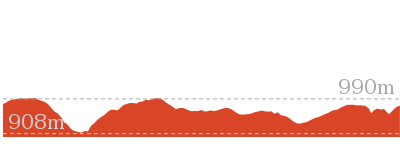
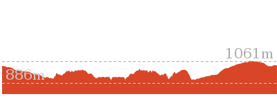
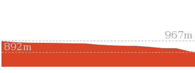
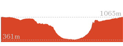
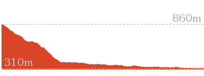
Cross sectional view of the Pulpit Rock car park to Middle Lookout bushwalking track
Analysis and summary of the altitude variation on the Pulpit Rock car park to Middle Lookout
Overview of this walks grade – based on the AS 2156.1 – 2001
Under this standard, a walk is graded based on the most difficult section of the walk.
| Length | 748 m | ||
| Time | 30 mins | ||
| . | |||
| Grade 3/6 Moderate track |
AS 2156.1 | Gradient | Short steep hills (3/6) |
| Quality of track | Formed track, with some branches and other obstacles (3/6) | ||
| Signs | Directional signs along the way (3/6) | ||
| Experience Required | No experience required (1/6) | ||
| Weather | Weather generally has little impact on safety (1/6) | ||
| Infrastructure | Limited facilities, not all cliffs are fenced (3/6) |
Some more details of this walks Grading
Here is a bit more details explaining grading looking at sections of the walk
Gradient
This whole walk, 370m has short steep hills.
Quality of track
This whole walk, 370m follows a formed track, with some branches and other obstacles.
Signs
Around 270m of this walk has directional signs at most intersection, whilst the remaining 110m is clearly signposted.
Experience Required
This whole walk, 370m requires no previous bushwalking experience.
weather
This whole walk, 370m is not usually affected by severe weather events (that would unexpectedly impact safety and navigation).
Infrastructure
Around 270m of this walk is close to useful facilities (such as fenced cliffs and seats), whilst the remaining 110m has limited facilities (such as not all cliffs fenced).
Similar walks
A list of walks that share part of the track with the Pulpit Rock car park to Middle Lookout walk.
630 m Return
30 mins
Moderate track
816 m Return
45 mins
Hard track
3.8 km One way
2 hrs 30 mins
Hard track
4.2 km One way
2 hrs 30 mins
Hard track
6.6 km One way
4 hrs 15 mins
Hard track
13.6 km Circuit
8 hrs
Hard track
Other Nearby walks
A list of walks that start near the Pulpit Rock car park to Middle Lookout walk.
3.2 km One way
1 hr 45 mins
Hard track
1.4 km Return
1 Hr
Hard track
1.2 km Return
1 hr 45 mins
Hard track
588 m Return
30 mins
Very easy
2.4 km Circuit
1 Hr
Very easy
1.9 km One way
45 mins
Very easy
7.6 km Return
3 hrs 30 mins
Hard track
460 m Return
15 mins
Moderate track
400 m Return
15 mins
Easy track
4.3 km Return
4 hrs
Hard track
12.8 km One way
2 Days
Hard track
8.1 km One way
5 hrs 30 mins
Hard track
Plan your trip to and from the walk here
The Pulpit Rock car park to Middle Lookout walk starts and ends at the Pulpit Rock car park (gps: -33.61801, 150.32846)
Your main transport option to Pulpit Rock car park is by;
![]() Car. There is free parking available.
Car. There is free parking available.
(get details)
Short URL = http://wild.tl/prcptml
Gallery images
There are other downloads I am still working on.
You will probably need to login to access these — still all free.
* KML (google earth file)
* GPX (GPS file)
Special Maps/ brochures
* A3 topo maps
* PDF with Lands Topo map base
* PDF with arial image (and map overlay)
I wanted to get the main site live first, this extra stuff will come in time.
Happy walking
Matt 🙂
Pulpit Rock, Boyd Beach to Govetts Leap Lookout

2 hrs 30 mins
4.2 km One way
445 m
Hard track
This section of the Cliff Top Track takes in the beautiful scenery east of Blackheath. The track leaves Pulpit Rock car park and drops into many lookouts with views over waterfalls and the Grose Valley. The track heads out to the secluded creek bank of Boyd Beach, and then continues, back along the track, and climbs to the magnificent views from Govetts Leap Lookout.


(0km) Pulpit Rock car park → Int. Pulpit Rock Trk and Pulpit Rock Lookout Trk
270 m
8 mins
0m
-36m
Moderate track
From the car park, the walk follows the sign to ‘Pulpit Rock Lookout’[1], down the stairs from the car park. The track continues down to a shelter and toilet, and then steeply heads down another flight of stairs, before flattening out and then descending more stairs to the signposted intersection.
(0.27km) Int. Pulpit Rock Trk and Pulpit Rock Lookout Trk → Pulpit Rock Upper Lookout
50 m
1 mins
0m
-14m
Moderate track
Continue straight: From the intersection, this walk goes down the stairs, following the sign to ‘Pulpit Rock’. The track heads down the hill to a flat area with awesome views over the Grose Valley. At the end of this side trip, retrace your steps back to the main walk then Turn right.
Pulpit Rock Lookout
Pulpit Rock Lookout, Blue Mountains National Park, looks over the Grose Valley and back towards Blackheath, with Bridal Veil Falls and the Govetts Leap cliff edge in view. The lookout has many levels with the uppermost lookout having the easiest access.
(0.27km) Int. Pulpit Rock Trk and Pulpit Rock Lookout Trk → Int. Popes Glen Trk and Pulpit Rock Trk
2.8 km
1 hr 31 mins
318m
-328m
Moderate track
Turn right: From the intersection, this walk does not follow the signs to the ‘Carpark’ or ‘Pulpit Rock’, but instead leads away from the stairs and into a gully. The track rounds the gully, dropping into a creek before it heading uphill to the cliff tops again. The track continues to undulate along the clifftops, with the views of the valley to the left. The track winds in and out of gullys for approximately 1km to the fenced viewing area of Boyd Lookout.
Continue straight: From the lookout, this walk heads along the hillside with the valley below to the left. The track leads along the hillside for some time, in and out of gullys, to then head down into a gully facing Horseshoe Falls. The track rounds the gully, passing across a creek to a railed lookout on the left. The track then heads under a cliffline to a railed section of track, which winds down the hill steeply to the street-signposted intersection after Popes Glen Creek.
Continue straight: From the lookout, this walk heads along the hillside with the valley below to the left. The track leads along the hillside for some time, in and out of gullys, to then head down into a gully facing Horseshoe Falls. The track rounds the gully, passing across a creek to a railed lookout on the left. The track then heads under a cliffline to a railed section of track, which winds down the hill steeply to the street-signposted intersection after Popes Glen Creek.
Boyd Lookout
Boyd Lookout, Blue Mountains National Park, looks over the Grose Valley with a spectacular view over Pulpit Rock to the east. It is an unfenced, informal lookout.
(3.06km) Int. Popes Glen Trk and Pulpit Rock Trk → Boyd Beach
340 m
8 mins
21m
-18m
Moderate track
Veer right: From the intersection, this walk follows the sign to ‘Popes Glen’ keeping the creek below on the right. The track continues for approximately 100m, rising to the left of a prominent rock feature. The walk passes another track on the right (with access to the creek), then continues to rise past the rock feature (on the right – The rock feature has a trail to its top.) This walk continues from the rock feature, heading down the hill to a signposted intersection.
Turn right: From the intersection, this walk heads down the hill following the ‘Boyds Beach’ sign (under the bush). The walk winds down the rocky steps for approximately 40m to Boyd Beach.
Turn right: From the intersection, this walk heads down the hill following the ‘Boyds Beach’ sign (under the bush). The walk winds down the rocky steps for approximately 40m to Boyd Beach.
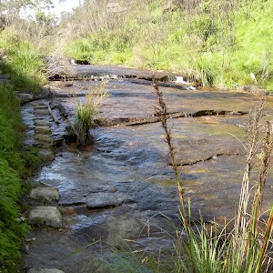
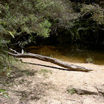
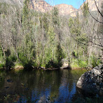
Boyd Beach

Boyd Beach, Blue Mountains National Park, is a small sandy bank on Popes Glen Creek. The beach is a quiet spot with nice ferns and shade. The beach is a short distance from the Popes Glen track.
(3.41km) Boyd Beach → Horseshoe Falls Lookout
480 m
12 mins
44m
-31m
Moderate track
Turn around: From Boyd Beach, this walk heads up the hill away from the creek, winding up the rocky steps for approximately 40m to the signposted intersection.
Turn left: From the intersection, this walk follows the ‘Govetts Leap’ sign, climbing for approximately 50m past a rock feature (below on the left – there is a track to the top of this feature). The walk continues along the creek line, keeping the creek on the left, and passes a track (accessing the creek). This walk continues for approximately 100m, heading through a ferny area to an intersection near the creek, marked by ‘Popes Glen’ and ‘Govetts Leap’ signs.
Continue straight: From the intersection, this walk follows the ‘Govetts Leap’ sign through the ferns, with the creek to the left of the track, and comes to a set of stairs. The walk climbs the steep stairs to follow the railing around a rocky outcrop. The track then winds along the hillside for some time heading to pass a lookout on the left, as the track continues to the intersection near the Horseshoe Falls Lookout.
Horseshoe Falls
Horseshoe Falls, Blue Mountains National Park, are sourced by Popes Glen Creek which runs over the cliff into the Grose Valley. The Horseshoe Falls seem to be named after the shape of the valley into which they drop.
(3.88km) Horseshoe Falls Lookout → Govetts Leap Lookout
340 m
11 mins
62m
-23m
Hard track
Continue straight: From the intersection, this walk winds along the cliff top with the valley below to the left. The walk then leads steeply up the stairs to the intersection at the viewing area.
Veer right: From the intersection, this walk heads up the stairs, keeping the valley to the left. The walk heads up and around the hillside to cross over a bridge, then up more stairs to the intersection.
Turn right: From the intersection, this walk heads across the grassed area towards a platform structure. The walk climbs some stairs onto Govetts Leap Lookout, with its great views and sandstone monuments.
Govetts Leap Lookout
Govetts Leap Lookout is named after the first European man to have enjoyed this view, William Govett, as an assistant surveyor in June 1831. Govetts Leap Lookout offers wonderful views over the Grose Valley and the spectacular Bridal Falls. The word `leap` is an old Scottish word meaning waterfall. The lookout is easily accessed from the car park[4], there are also toilets[5]
and picnic shelters[6]
nearby.
Maps for the Pulpit Rock, Boyd Beach to Govetts Leap Lookout walk
You can download the PDF for this walk to print a map.
These maps below cover the walk and the wider area around the walk, they are worth carrying for safety reasons.
| Katoomba | 1:25 000 Map Series | 89301S KATOOMBA | NSW-89301S |
| Mount Wilson | 1:25 000 Map Series | 89301N MOUNT WILSON | NSW-89301N |
| Katoomba | 1:100 000 Map Series | 8930 KATOOMBA | 8930 |
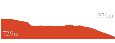
Cross sectional view of the Pulpit Rock, Boyd Beach to Govetts Leap Lookout bushwalking track
Analysis and summary of the altitude variation on the Pulpit Rock, Boyd Beach to Govetts Leap Lookout
Overview of this walks grade – based on the AS 2156.1 – 2001
Under this standard, a walk is graded based on the most difficult section of the walk.
| Length | 4.2 km | ||
| Time | 2 hrs 30 mins | ||
| . | |||
| Grade 4/6 Hard track |
AS 2156.1 | Gradient | Very steep (4/6) |
| Quality of track | Formed track, with some branches and other obstacles (3/6) | ||
| Signs | Directional signs along the way (3/6) | ||
| Experience Required | No experience required (1/6) | ||
| Weather | Weather generally has little impact on safety (1/6) | ||
| Infrastructure | Limited facilities, not all cliffs are fenced (3/6) |
Some more details of this walks Grading
Here is a bit more details explaining grading looking at sections of the walk
Gradient
4.1km of this walk has short steep hills and another 110m is very steep. The remaining (35m) has gentle hills with occasional steps.
Quality of track
Around 4.2km of this walk follows a formed track, with some branches and other obstacles, whilst the remaining 35m follows a clear and well formed track or trail.
Signs
Around 4.1km of this walk has directional signs at most intersection, whilst the remaining 150m is clearly signposted.
Experience Required
This whole walk, 4.2km requires no previous bushwalking experience.
weather
This whole walk, 4.2km is not usually affected by severe weather events (that would unexpectedly impact safety and navigation).
Infrastructure
Around 3.9km of this walk has limited facilities (such as not all cliffs fenced), whilst the remaining 300m is close to useful facilities (such as fenced cliffs and seats).
Similar walks
A list of walks that share part of the track with the Pulpit Rock, Boyd Beach to Govetts Leap Lookout walk.
630 m Return
30 mins
Moderate track
748 m Return
30 mins
Moderate track
816 m Return
45 mins
Hard track
1.2 km Return
1 hr 45 mins
Hard track
3.8 km One way
2 hrs 30 mins
Hard track
6.6 km One way
4 hrs 15 mins
Hard track
8.7 km Circuit
3 hrs 30 mins
Hard track
8.7 km Circuit
4 hrs 30 mins
Hard track
10.7 km Circuit
6 hrs 30 mins
Hard track
12.8 km One way
2 Days
Hard track
13.6 km Circuit
8 hrs
Hard track

15.6 km Circuit
7 hrs 30 mins
Hard track
16.5 km One way
2 Days
Hard track
17.6 km One way
9 hrs
Experienced only

18.2 km Circuit
8 hrs 30 mins
Hard track
22.2 km One way
2 Days
Experienced only
22.5 km One way
3 Days
Experienced only

24.1 km Circuit
2 Days
Hard track
Other Nearby walks
A list of walks that start near the Pulpit Rock, Boyd Beach to Govetts Leap Lookout walk.
3.2 km One way
1 hr 45 mins
Hard track
1.4 km Return
1 Hr
Hard track
588 m Return
30 mins
Very easy
2.4 km Circuit
1 Hr
Very easy
1.9 km One way
45 mins
Very easy
7.6 km Return
3 hrs 30 mins
Hard track
460 m Return
15 mins
Moderate track
400 m Return
15 mins
Easy track
4.3 km Return
4 hrs
Hard track
8.1 km One way
5 hrs 30 mins
Hard track
3.1 km Return
2 hrs
Hard track
6.4 km Circuit
4 hrs
Very experienced only
Plan your trip to and from the walk here
The Pulpit Rock, Boyd Beach to Govetts Leap Lookout walk starts at the Pulpit Rock car park (gps: -33.61801, 150.32846)
Your transport options to Pulpit Rock car park are by;
![]() Bus. (get details)
Bus. (get details)
![]() Car. There is free parking available.
Car. There is free parking available.
(get details)
The Pulpit Rock, Boyd Beach to Govetts Leap Lookout ends at the Govetts Leap Lookout (gps: -33.627976, 150.31134)
Your transport options to Govetts Leap Lookout are by;
![]() Bus. (get details)
Bus. (get details)
![]() Car. There is free parking available.
Car. There is free parking available.
(get details)
Short URL = http://wild.tl/prbbtgll
Gallery images
There are other downloads I am still working on.
You will probably need to login to access these — still all free.
* KML (google earth file)
* GPX (GPS file)
Special Maps/ brochures
* A3 topo maps
* PDF with Lands Topo map base
* PDF with arial image (and map overlay)
I wanted to get the main site live first, this extra stuff will come in time.
Happy walking
Matt 🙂
Perry’s Lookdown to Blackheath Station

2 Days
12.8 km One way
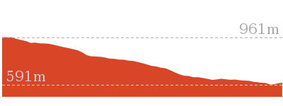
1128 m
Hard track
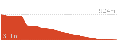
The walk descends from Perry’s Lookdown into the famous Blue Gum Forest. The overnight stay in the nearby Acacia Flats allows time for some exploring in the Grose River and the surrounding areas. After some steady climbing, the walk passes the base of the magnificent Bridal Falls and climbs steeply to Govetts Leap Lookout. This walk tests out the knees and fitness and is great way to access the valley.


Free Beacon Hire
A Personal Locating Beacon (PLB) is a hand-held device that, when triggered, sends a message to the emergency services with your location. The emergency services staff can then look at your trip intention forms and decide how best to help you. In the Blue Mountains, you can borrow these for no charge, just complete this Trip intention form, and a borrowing form. The device can be picked up from:
NPWS Office – Govetts Leap Rd Blackheath – 9am to 4pm 7 days Ph: 02 4787 8877
Katoomba Police Station – 217 Katoomba St Katoomba – Anytime Ph: 02 4782 8199
Springwood Police Station – 4 Jerseywold Avenue Springwood – Anytime Ph: 02 4751 0299
More info.
NPWS Office – Govetts Leap Rd Blackheath – 9am to 4pm 7 days Ph: 02 4787 8877
Katoomba Police Station – 217 Katoomba St Katoomba – Anytime Ph: 02 4782 8199
Springwood Police Station – 4 Jerseywold Avenue Springwood – Anytime Ph: 02 4751 0299
More info.
(0km) Perry’s Lookdown car park and camping area → Perry’s Lookdown
80 m
3 mins
0m
-16m
Moderate track
From the car park, the walk follows the sign ‘Perry’s Lookdown Track’ down the hill to a railed lookout.
Perry’s Lookdown
Perry’s Lookdown, Blue Mountains NP, has views over the Grose Valley, with Blue Gum Forest nearly directly below and Lockleys Pylon to the south. The lookout is presumably named after Captain William Perry, the Deputy Surveyor General who worked under the leadership of Sir Thomas Mitchell.
(0.08km) Perry’s Lookdown → Dockers Lookout
60 m
3 mins
0m
-28m
Moderate track
Continue straight: From the Perry’s Lookdown, the walk follows the railed stairs down the hill for a short time until coming to a intersection signposted ‘Perrys Track’ and ‘Dockers Lookout’.
Continue straight: From the intersection, the walk leads for a short distance down the railed path to the visible lookout area, Docker’s Lookout.
Continue straight: From the intersection, the walk leads for a short distance down the railed path to the visible lookout area, Docker’s Lookout.
Dockers Lookout

Dockers Lookout, Blue Mountains NP, has views over the Grose Valley and Blue Gum Forest below. Mt Banks can be seen standing proudly to the north above the valley.
(0.14km) Dockers Lookout → Blue Gum Forest intersection
2 km
1 hr 32 mins
35m
-603m
Hard track
Turn around: From Dockers Lookout, the walk heads up the railed path for a short distance until coming to a signposted intersection.
Veer left: From the intersection, the walk follows the ‘Perry’s Lookdown Track’ sign down the hill. The track cuts across the hill to a bridge, where the track turns left and contours around the hill, before descending onto a lookout with memorial plaque and fire box.
Continue straight: From the lookout, the walk keeps the valley below on the left and heads down the steep stairs, through the gap in the cliffs. The stairs and handrail climb down through the cliffs, descending away from the main cliff before coming onto the top of a spur. The track tends right, over and down the spurline, and winds sharply down the spurline as it steeply descends for some time. The track heads down the spur, flattening out a few times before coming onto the relative flats of the Blue Gum Forest. The track heads down through the forest for a short time to a signposted intersection.
Blue Gum Forest
Blue Gum Forest, Blue Mountains NP, is a large stand of Eucalyptus deanei trees on the junction of the Grose River and Govetts Creek. The magnificent trees stand tall on the flats with low vegetation beneath. The trees of Blue Gum Forest represent the protection efforts of Myles Dunphy, who lead a group to raise the 130 pounds required to buy the Blue Gum Forest – quite a sum in 1931 during the depression – and save it from being cleared. The group were successful and the Blue Gum Forest is now protected within the Blue Mountains National Park. More info.
(2.17km) Blue Gum Forest intersection → Acacia Flats Camping Ground
610 m
10 mins
4m
-4m
Moderate track
Turn right: From the intersection, this walk follows the sign ‘Camping only at Acacia Flats’, heading downstream. The track tends right, away from the Grose River and towards the hills on the right. The walk then heads downhill and across a small creek, after which it meanders for approximately 100m before arriving at Acacia Flats camping area.
Acacia Flats Camping Ground
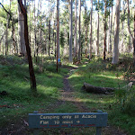
Acacia Flats Camping Ground, Blue Mountains NP, is situated on the floor of the Grose Valley between Perrys Lookdown and Lockley Pylon. The camp ground is approximately 50m from Govetts Creek and approximately 500m upstream from Blue Gum Forest. Acacia Flats Camping Ground is appropriately named after the dense population of Acacias found in this area. Acacia Flats is a wonderful area to camp with tall shady Blue Gums and level grass clearings which make for a great place to pitch a tent. There is a pit toilet and sitting logs to make camping more comfortable, and plenty of room for large groups. Water is available from Govetts Creek (treat before drinking).
End of day 1
This is the planned overnight stay for the end of day 1, happy camping.
(2.78km) Acacia Flats Camping Ground → Junction Rock
3 km
1 hr 2 mins
130m
-80m
Moderate track
Continue straight: From Acacia Flats camping area, the walk leaves the camping area with the Grose River far to the left and the majority of the camping areas to the right of the track. The walk passes a pit toilet on the right after approximately 100m. Continuing along the creek flats before climbing up a small hill, the track contours and undulates for approximately 600m to round a hill which gives views of Pulpit Rock above on the cliffs. The track turns right to climb up the hill, and then left to contour for some time. As the slope lessens, the track descends to the creek bank, which is on the the right. The track continues to contour for approximately 1km just above the creek, on a steep bank which has minor undulations, until it comes across a clearing with a ‘No Camping’ sign. The track turns left here and descends to the creek bank at a signposted intersection of Junction Rock. Junction Rock ‘intersection’ sits in the middle of the creek.
Junction Rock
Junction Rock, Blue Mountains NP, is a rock situated in the middle of the Govetts Leap Brook and Govetts Creek junction. The rock is signposted, giving directions to Evans Lookout, Neates Glen, Acacia Flats and the Blue Gum Forest. Junction Rock is a great place for lunch and a swim in summer.
(5.76km) Junction Rock → Bottom of Govetts Leap falls
2.4 km
1 hr 15 mins
390m
-22m
Moderate track
Veer right: From Junction Rock, the walk follows the ‘Govetts Leap’ sign, soon crossing the brook. The track then follows the brook for approximately 150m, to another creek crossing. The track continues, with the creek now on its left, for approximately 60m, before crossing back to the other bank. The track continues for approximately 1km with the creek to the right, and undulates steeply in sections between magnificent waterfalls. A section of track traverses a rock shelf for a short stretch, before continuing to wind up and down (with the creek to the right) to a few sets of steeply-cut stairs. From these, the walk continues to wind over hills to a creek crossing. The track then heads up the spur, winding between views of waterfalls, before tending left further up the hill. The walk leads up the winding steps for some time, until crossing the creek at the bottom of a waterfall cascading off the large cliffs – Govetts Leap falls.
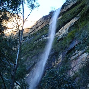
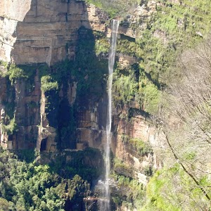
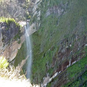
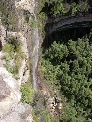
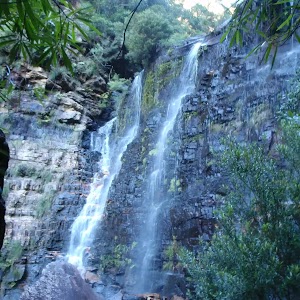
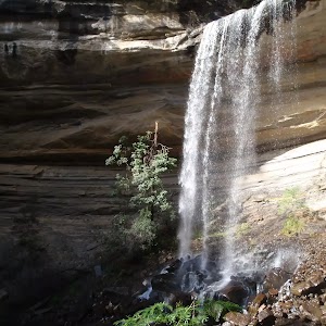
Govetts Leap (falls)
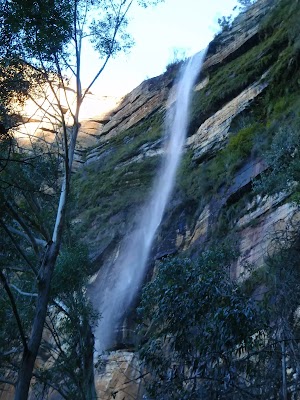
Govetts Leap, is a waterfall in the Blue Mountains National Park. The fall is fed by Govetts Leap Brook which runs over the cliff into the Grose Valley. The falls are best viewed from Govetts Leap and Barrow Lookouts. Leap is a scots dialect word for cataract or waterfall.
(8.11km) Bottom of Govetts Leap falls → Govetts Leap Lookout
610 m
42 mins
305m
-61m
Hard track
Continue straight: From the bottom of Govetts Leap Falls, this walk heads north-west, following the blue signs up the hill. The track zigzags its way steeply up to a wall of rock covered by moss, ferns and grasses. The track passes along the base of this cliff to a metal staircase, passing through the rock. The track continues to wind steeply below the cliffline, passing two lookouts before coming to the signposted intersection.
Continue straight: From the intersection, this walk follows the sign to ‘Govetts Leap carpark’ up the stairs. The walk zigzags up the hill before tending left to the signposted intersection.
Turn left: From the intersection, this walk heads across the grassed area towards a platform structure. The walk climbs some stairs onto Govetts Leap Lookout, with its great views and sandstone monuments.
Govetts Leap Lookout
Govetts Leap Lookout is named after the first European man to have enjoyed this view, William Govett, as an assistant surveyor in June 1831. Govetts Leap Lookout offers wonderful views over the Grose Valley and the spectacular Bridal Falls. The word `leap` is an old Scottish word meaning waterfall. The lookout is easily accessed from the car park[3], there are also toilets[4]
and picnic shelters[5]
nearby.
(8.72km) Govetts Leap Lookout → Horseshoe Falls Lookout
340 m
11 mins
23m
-62m
Hard track
Turn around: From Govetts Leap Lookout, this walk heads down the stairs at the edge of the lookout, keeping the valley to the right. The walk then crosses a grassed area to a well-signposted intersection on the edge of the tree line.
Turn left: From the intersection, this walk heads down some stairs, keeping the valley to the right. The walk turns right over a bridge, continuing around the hillside to drop down onto a viewing area and intersection.
Veer left: From the intersection, this walk heads down steep stairs, keeping the valley to the right. The track then winds along the cliff top until coming to an intersection, near Horseshoe Falls Lookout.
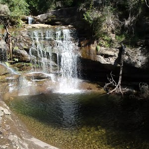
Horseshoe Falls Lookout
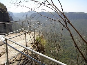
Horseshoe Falls Lookout, Blue Mountains National Park, is a small fenced lookout. There are views down to Horseshoe Falls and across the Grose Valley.
Horseshoe Falls
Horseshoe Falls, Blue Mountains National Park, are sourced by Popes Glen Creek which runs over the cliff into the Grose Valley. The Horseshoe Falls seem to be named after the shape of the valley into which they drop.
(9.05km) Horseshoe Falls Lookout → Int. Popes Glen Trk and Boyd Bch Trk
440 m
11 mins
31m
-41m
Moderate track
Continue straight: From the intersection, this walk heads along the cliff top towards Horseshoe Falls, with the valley below to the right. The track winds for some time around the hillside, to a lookout on the right, before continuing around to a railing some steep stairs. The stairs lead to Popes Glen Creek, where the track continues through the ferns to meet a street sign.
Continue straight: From the intersection, this walk follows the sign to ‘Popes Glen’ keeping the creek below on the right. The track continues for approximately 100m, rising to the left of a prominent rock feature. The walk passes another track on the right (with access to the creek), then continues to rise past the rock feature (on the right – The rock feature has a trail to its top.) This walk continues from the rock feature, heading down the hill to a signposted intersection.
Continue straight: From the intersection, this walk follows the sign to ‘Popes Glen’ keeping the creek below on the right. The track continues for approximately 100m, rising to the left of a prominent rock feature. The walk passes another track on the right (with access to the creek), then continues to rise past the rock feature (on the right – The rock feature has a trail to its top.) This walk continues from the rock feature, heading down the hill to a signposted intersection.
(9.49km) Int. Popes Glen Trk and Boyd Bch Trk → Boyd Beach
40 m
1 mins
0m
-3m
Moderate track
Turn right: From the intersection, this walk heads down the hill following the ‘Boyds Beach’ sign (under the bush). The walk winds down the rocky steps for approximately 40m to Boyd Beach. At the end of this side trip, retrace your steps back to the main walk then Continue straight.
Boyd Beach
Boyd Beach, Blue Mountains National Park, is a small sandy bank on Popes Glen Creek. The beach is a quiet spot with nice ferns and shade. The beach is a short distance from the Popes Glen track.
(9.49km) Int. Popes Glen Trk and Boyd Bch Trk → Int. Popes Glen Trk and Dell St
2.1 km
49 mins
145m
-48m
Moderate track
Turn left : From the intersection, this walk heads up the hill, following the arrow on the sign pointing to ‘Blackheath’. The track continues above the creek (on the right) for some time, then crosses a bridge so that the creek is now on the left. The walk crosses a second bridge, then continues for some time up a rocky hill to an intersection below power lines, with a bridge below on the right.
Continue straight: From the intersection, this walk heads up the hill, keeping the creek below on the right. The walk soon crosses the creek at a bridge, continuing along the other side to a small waterfall (on the left). The track then continues up the hill for for a short time, passing an intersection (with access tracks to Clarence Rd). The track continues to head up the hill for approximately 300m to the intersection with Dell St.
Continue straight: From the intersection, this walk heads up the hill, keeping the creek below on the right. The walk soon crosses the creek at a bridge, continuing along the other side to a small waterfall (on the left). The track then continues up the hill for for a short time, passing an intersection (with access tracks to Clarence Rd). The track continues to head up the hill for approximately 300m to the intersection with Dell St.
(11.61km) Int. Pope’s Glen Trk and Dell St → Blackheath Station
1.2 km
26 mins
65m
-27m
Moderate track
Veer left: From the intersection, this walk heads down Dell St, keeping the bush to the left of the road and houses to the right. The walk soon passes Cleopatra St on the right and continues along Dell St to the intersection with Gipps Lane, on the right (where Dell St changes name to Wills St).
Turn right: From the intersection, this walk heads along Gipps Lane, passing a large wooden house to the right of the road. The road tends left onto Robertson Lane which then becomes Wills St. The walk follows Wills Street for sometime to turn left onto Inconstant St and then right onto Gardiner Cres. Gardiner Cres is followed to the Great Western Highway, where there is a petrol station on the left. From here, this walk turns left to follow the Great Western Highway, keeping the petrol station on the left, as the walk heads towards the Gardners Inn pub. This walk continues to the pedestrian crossing, opposite Blackheath Station steps.
Turn right: From the pedestrian crossing, this walk crosses the Great Western Highway to turn right up the covered station steps. The walk follows the railway bridge to the top of the station staircase.
Maps for the Perry’s Lookdown to Blackheath Station walk
You can download the PDF for this walk to print a map.
These maps below cover the walk and the wider area around the walk, they are worth carrying for safety reasons.
| Katoomba | 1:25 000 Map Series | 89301S KATOOMBA | NSW-89301S |
| Mount Wilson | 1:25 000 Map Series | 89301N MOUNT WILSON | NSW-89301N |
| Katoomba | 1:100 000 Map Series | 8930 KATOOMBA | 8930 |
Cross sectional view of the Perry’s Lookdown to Blackheath Station bushwalking track
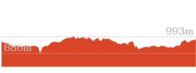
Analysis and summary of the altitude variation on the Perry’s Lookdown to Blackheath Station
Daily actual walking time estimates
| Day | Walking Time | Length |
|---|---|---|
| 1 | 1 hr 48 mins | 2.8 km |
| 2 | 4 hrs 37 mins | 10 km |
Overview of this walks grade – based on the AS 2156.1 – 2001
Under this standard, a walk is graded based on the most difficult section of the walk.
| Length | 12.8 km | ||
| Time | 2 Days | ||
| . | |||
| Grade 4/6 Hard track |
AS 2156.1 | Gradient | Very steep (4/6) |
| Quality of track | Rough track, where fallen trees and other obstacles are likely (4/6) | ||
| Signs | Directional signs along the way (3/6) | ||
| Experience Required | Some bushwalking experience recommended (3/6) | ||
| Weather | Weather generally has little impact on safety (1/6) | ||
| Infrastructure | Limited facilities (such as cliffs not fenced, significant creeks not bridged) (4/6) |
Some more details of this walks Grading
Here is a bit more details explaining grading looking at sections of the walk
Gradient
9km of this walk has short steep hills and another 2.5km is very steep. Whilst another 970m has gentle hills with occasional steps and the remaining 830m is flat with no steps.
Quality of track
10km of this walk follows a formed track, with some branches and other obstacles and another 1.9km follows a rough track, where fallen trees and other obstacles are likely. Whilst another 1.2km follows a smooth and hardened path and the remaining 75m follows a clear and well formed track or trail.
Signs
Around 11km of this walk has directional signs at most intersection, whilst the remaining 1.8km is clearly signposted.
Experience Required
Around 10km of this walk requires no previous bushwalking experience, whilst the remaining 2.8km requires some bushwalking experience.
weather
This whole walk, 13km is not usually affected by severe weather events (that would unexpectedly impact safety and navigation).
Infrastructure
10km of this walk has limited facilities (such as not all cliffs fenced) and another 1.8km has limited facilities (such as cliffs not fenced, significant creeks not bridged). The remaining (1.4km) is close to useful facilities (such as fenced cliffs and seats).
Similar walks
A list of walks that share part of the track with the Perry’s Lookdown to Blackheath Station walk.
1.2 km Return
1 hr 45 mins
Hard track
3.8 km One way
2 hrs 30 mins
Hard track
4.2 km One way
2 hrs 30 mins
Hard track
4.3 km Return
4 hrs
Hard track
6.6 km One way
4 hrs 15 mins
Hard track
8.1 km One way
5 hrs 30 mins
Hard track
8.7 km Circuit
3 hrs 30 mins
Hard track
8.7 km Circuit
4 hrs 30 mins
Hard track
10.4 km One way
5 hrs 30 mins
Experienced only
10.7 km Circuit
6 hrs 30 mins
Hard track
13.6 km Circuit
8 hrs
Hard track
13.8 km One way
8 hrs
Experienced only
14 km Return
6 hrs 30 mins
Experienced only
15.6 km Circuit
7 hrs 30 mins
Hard track
16.5 km One way
2 Days
Hard track
17.6 km One way
9 hrs
Experienced only
18.2 km Circuit
8 hrs 30 mins
Hard track
22.2 km One way
2 Days
Experienced only
22.5 km One way
3 Days
Experienced only
24.1 km Circuit
2 Days
Hard track
Other Nearby walks
A list of walks that start near the Perry’s Lookdown to Blackheath Station walk.
400 m Return
15 mins
Easy track
460 m Return
15 mins
Moderate track
816 m Return
45 mins
Hard track
748 m Return
30 mins
Moderate track
630 m Return
30 mins
Moderate track
7.6 km Return
3 hrs 30 mins
Hard track
3.2 km One way
1 hr 45 mins
Hard track
1.4 km Return
1 Hr
Hard track
588 m Return
30 mins
Very easy
2.4 km Circuit
1 Hr
Very easy
1.9 km One way
45 mins
Very easy
3.1 km Return
2 hrs
Hard track
Plan your trip to and from the walk here
The Perry’s Lookdown to Blackheath Station walk starts at the Perry’s Lookdown car park and camping area (gps: -33.599394, 150.34602)
Your main transport option to Perry’s Lookdown car park and camping area is by;
![]() Car. There is free parking available.
Car. There is free parking available.
(get details)
The Perry’s Lookdown to Blackheath Station ends at the Blackheath Station (gps: -33.633876, 150.2844)
Your transport options to Blackheath Station are by;
![]() Train. (get details)
Train. (get details)
![]() Bus. (get details)
Bus. (get details)
![]() Car. There is free parking available.
Car. There is free parking available.
(get details)
Short URL = http://wild.tl/pltbs
Gallery images
There are other downloads I am still working on.
You will probably need to login to access these — still all free.
* KML (google earth file)
* GPX (GPS file)
Special Maps/ brochures
* A3 topo maps
* PDF with Lands Topo map base
* PDF with arial image (and map overlay)
I wanted to get the main site live first, this extra stuff will come in time.
Happy walking
Matt 🙂
Pulpit Rock car park to lower Lookout

45 mins
816 m Return
145 m
Hard track
This walk takes in the fabulous views across the Grose Valley. It covers the combination of the upper lookout, providing the easiest access, the middle lookout, and the lower lookout, which involves many more stairs. The upper lookout gives the best views across the valley, while the middle lookout gives similar scenic views. The lower lookout, however, has great views of the cliffs around the Grose Valley from a unique perspective.


(0km) Pulpit Rock car park → Pulpit Rock Upper Lookout
320 m
9 mins
0m
-50m
Moderate track
From the car park, the walk follows the sign to ‘Pulpit Rock Lookout’[1], down the stairs from the car park. The track continues down to a shelter and toilet, and then steeply heads down another flight of stairs, before flattening out and then descending more stairs to the signposted intersection.
Continue straight: From the intersection, this walk goes down the stairs, following the sign to ‘Pulpit Rock’. The track heads down the hill to a flat area with awesome views over the Grose Valley.
Continue straight: From the intersection, this walk goes down the stairs, following the sign to ‘Pulpit Rock’. The track heads down the hill to a flat area with awesome views over the Grose Valley.
Pulpit Rock Lookout
Pulpit Rock Lookout, Blue Mountains National Park, looks over the Grose Valley and back towards Blackheath, with Bridal Veil Falls and the Govetts Leap cliff edge in view. The lookout has many levels with the uppermost lookout having the easiest access.
(0.32km) Pulpit Rock upper Lookout → Pulpit Rock middle Lookout
60 m
4 mins
10m
-36m
Moderate track
Veer left: From the upper lookout, this walk heads down the long set of stairs towards Pulpit Rock (a bench seat is visible from here). The walk passes a side path (which leads to a cave) and continues down to the bench seat in the middle of the platform.
(0.37km) Pulpit Rock Middle Lookout → Pulpit Rock lower Lookout
30 m
3 mins
0m
-49m
Hard track
Continue straight: From the middle lookout seat, this walk heads to the end of the viewing area and heads down a set of stairs. The track follows a boardwalked section of track to a second similar viewing area with a seat. The walk then steeply descends a flight of metal stairs to a small viewing platform.
Maps for the Pulpit Rock car park to lower Lookout walk
You can download the PDF for this walk to print a map.
These maps below cover the walk and the wider area around the walk, they are worth carrying for safety reasons.
| Mount Wilson | 1:25 000 Map Series | 89301N MOUNT WILSON | NSW-89301N |
| Katoomba | 1:100 000 Map Series | 8930 KATOOMBA | 8930 |
Cross sectional view of the Pulpit Rock car park to lower Lookout bushwalking track
Analysis and summary of the altitude variation on the Pulpit Rock car park to lower Lookout
Overview of this walks grade – based on the AS 2156.1 – 2001
Under this standard, a walk is graded based on the most difficult section of the walk.
| Length | 816 m | ||
| Time | 45 mins | ||
| . | |||
| Grade 4/6 Hard track |
AS 2156.1 | Gradient | Very steep (4/6) |
| Quality of track | Rough track, where fallen trees and other obstacles are likely (4/6) | ||
| Signs | Minimal directional signs (4/6) | ||
| Experience Required | Some bushwalking experience recommended (3/6) | ||
| Weather | Weather generally has little impact on safety (1/6) | ||
| Infrastructure | Limited facilities (such as cliffs not fenced, significant creeks not bridged) (4/6) |
Some more details of this walks Grading
Here is a bit more details explaining grading looking at sections of the walk
Gradient
Around 370m of this walk has short steep hills, whilst the remaining 35m is very steep.
Quality of track
Around 370m of this walk follows a formed track, with some branches and other obstacles, whilst the remaining 35m follows a rough track, where fallen trees and other obstacles are likely.
Signs
270m of this walk has directional signs at most intersection and another 110m is clearly signposted. The remaining (35m) has minimal directional signs.
Experience Required
Around 370m of this walk requires no previous bushwalking experience, whilst the remaining 35m requires some bushwalking experience.
weather
This whole walk, 410m is not usually affected by severe weather events (that would unexpectedly impact safety and navigation).
Infrastructure
270m of this walk is close to useful facilities (such as fenced cliffs and seats) and another 110m has limited facilities (such as not all cliffs fenced). The remaining (35m) has limited facilities (such as cliffs not fenced, significant creeks not bridged).
Similar walks
A list of walks that share part of the track with the Pulpit Rock car park to lower Lookout walk.
630 m Return
30 mins
Moderate track
748 m Return
30 mins
Moderate track
3.8 km One way
2 hrs 30 mins
Hard track
4.2 km One way
2 hrs 30 mins
Hard track
6.6 km One way
4 hrs 15 mins
Hard track
13.6 km Circuit
8 hrs
Hard track
Other Nearby walks
A list of walks that start near the Pulpit Rock car park to lower Lookout walk.
3.2 km One way
1 hr 45 mins
Hard track
1.4 km Return
1 Hr
Hard track
1.2 km Return
1 hr 45 mins
Hard track
588 m Return
30 mins
Very easy
2.4 km Circuit
1 Hr
Very easy
1.9 km One way
45 mins
Very easy
7.6 km Return
3 hrs 30 mins
Hard track
460 m Return
15 mins
Moderate track
400 m Return
15 mins
Easy track
4.3 km Return
4 hrs
Hard track
12.8 km One way
2 Days
Hard track
8.1 km One way
5 hrs 30 mins
Hard track
Plan your trip to and from the walk here
The Pulpit Rock car park to lower Lookout walk starts and ends at the Pulpit Rock car park (gps: -33.61801, 150.32846)
Your main transport option to Pulpit Rock car park is by;
![]() Car. There is free parking available.
Car. There is free parking available.
(get details)
Short URL = http://wild.tl/prblxx
Gallery images
There are other downloads I am still working on.
You will probably need to login to access these — still all free.
* KML (google earth file)
* GPX (GPS file)
Special Maps/ brochures
* A3 topo maps
* PDF with Lands Topo map base
* PDF with arial image (and map overlay)
I wanted to get the main site live first, this extra stuff will come in time.
Happy walking
Matt 🙂
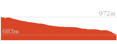
Perrys Lookdown to Blue Gum Forest
And Walk
Perrys Lookdown to Blue Gum Forest
4 hrs
4.3 km Return
656 m
Hard track
The wonderful walk from Perrys Lookdown into the Blue Gum Forest follows a clear an steep track into one of the region’s bushwalking and conservation icons. Allow plenty of time to explore the majestic Blue Gum Forest, looking up the tall trees and enjoying the birds flying through the area. The track is steep and the valley tempts visitors to stay and enjoy for a long time. If you want to stay overnight, Acacia Flats campsite is only 500m from the forest. To return to the car park, retrace your steps up the hill.


Perrys Lookdown campground
Perrys Lookdown offers a simple campsite, close to some spectacular lookouts and well located as starting point for longer walks exploring the Grose Valley. There are 5 tent sites and a non-flush toilet, but no water available. This area allows fuel stoves only (no camp fires). The camping area is a short walk from the car park. Limit to one night stay (sites cannot be reserved).
(0km) Perry’s Lookdown car park and camping area → Perry’s Lookdown
80 m
3 mins
0m
-16m
Moderate track
From the car park, the walk follows the sign ‘Perry’s Lookdown Track’ down the hill to a railed lookout.
Perry’s Lookdown
Perry’s Lookdown, Blue Mountains NP, has views over the Grose Valley, with Blue Gum Forest nearly directly below and Lockleys Pylon to the south. The lookout is presumably named after Captain William Perry, the Deputy Surveyor General who worked under the leadership of Sir Thomas Mitchell.
(0.08km) Perry’s Lookdown → Int. Perry’s and Dockers Lookout Tracks
40 m
2 mins
0m
-15m
Moderate track
Continue straight: From the Perry’s Lookdown, the walk follows the railed stairs down the hill for a short time until coming to a intersection signposted ‘Perrys Track’ and ‘Dockers Lookout’.
(0.12km) Int. Perry’s and Dockers Lookout Tracks → Dockers Lookout
20 m
1 mins
0m
-13m
Moderate track
Continue straight: From the intersection, the walk leads for a short distance down the railed path to the visible lookout area, Docker’s Lookout. At the end of this side trip, retrace your steps back to the main walk then Veer left.
Dockers Lookout
Dockers Lookout, Blue Mountains NP, has views over the Grose Valley and Blue Gum Forest below. Mt Banks can be seen standing proudly to the north above the valley.
(0.12km) Int. Perry’s and Dockers Lookout Tracks → Blue Gum Forest intersection
2 km
1 hr 31 mins
22m
-603m
Hard track
Turn sharp right: From the intersection, the walk follows the ‘Perry’s Lookdown Track’ sign down the hill. The track cuts across the hill to a bridge, where the track turns left and contours around the hill, before descending onto a lookout with memorial plaque and fire box.
Continue straight: From the lookout, the walk keeps the valley below on the left and heads down the steep stairs, through the gap in the cliffs. The stairs and handrail climb down through the cliffs, descending away from the main cliff before coming onto the top of a spur. The track tends right, over and down the spurline, and winds sharply down the spurline as it steeply descends for some time. The track heads down the spur, flattening out a few times before coming onto the relative flats of the Blue Gum Forest. The track heads down through the forest for a short time to a signposted intersection.
Continue straight: From the lookout, the walk keeps the valley below on the left and heads down the steep stairs, through the gap in the cliffs. The stairs and handrail climb down through the cliffs, descending away from the main cliff before coming onto the top of a spur. The track tends right, over and down the spurline, and winds sharply down the spurline as it steeply descends for some time. The track heads down the spur, flattening out a few times before coming onto the relative flats of the Blue Gum Forest. The track heads down through the forest for a short time to a signposted intersection.
Blue Gum Forest
Blue Gum Forest, Blue Mountains NP, is a large stand of Eucalyptus deanei trees on the junction of the Grose River and Govetts Creek. The magnificent trees stand tall on the flats with low vegetation beneath. The trees of Blue Gum Forest represent the protection efforts of Myles Dunphy, who lead a group to raise the 130 pounds required to buy the Blue Gum Forest – quite a sum in 1931 during the depression – and save it from being cleared. The group were successful and the Blue Gum Forest is now protected within the Blue Mountains National Park. More info.
(2.14km) Blue Gum Forest intersection → Acacia Flats Camping Ground
610 m
10 mins
4m
-4m
Moderate track
Turn right: From the intersection, this walk follows the sign ‘Camping only at Acacia Flats’, heading downstream. The track tends right, away from the Grose River and towards the hills on the right. The walk then heads downhill and across a small creek, after which it meanders for approximately 100m before arriving at Acacia Flats camping area. At the end of this side trip, retrace your steps back to the main walk then Continue straight.
Acacia Flats Camping Ground
Acacia Flats Camping Ground, Blue Mountains NP, is situated on the floor of the Grose Valley between Perrys Lookdown and Lockley Pylon. The camp ground is approximately 50m from Govetts Creek and approximately 500m upstream from Blue Gum Forest. Acacia Flats Camping Ground is appropriately named after the dense population of Acacias found in this area. Acacia Flats is a wonderful area to camp with tall shady Blue Gums and level grass clearings which make for a great place to pitch a tent. There is a pit toilet and sitting logs to make camping more comfortable, and plenty of room for large groups. Water is available from Govetts Creek (treat before drinking).
Maps for the Perrys Lookdown to Blue Gum Forest walk
You can download the PDF for this walk to print a map.
These maps below cover the walk and the wider area around the walk, they are worth carrying for safety reasons.
| Mount Wilson | 1:25 000 Map Series | 89301N MOUNT WILSON | NSW-89301N |
| Katoomba | 1:100 000 Map Series | 8930 KATOOMBA | 8930 |
Cross sectional view of the Perrys Lookdown to Blue Gum Forest bushwalking track
Analysis and summary of the altitude variation on the Perrys Lookdown to Blue Gum Forest
Overview of this walks grade – based on the AS 2156.1 – 2001
Under this standard, a walk is graded based on the most difficult section of the walk.
| Length | 4.3 km | ||
| Time | 4 hrs | ||
| . | |||
| Grade 4/6 Hard track |
AS 2156.1 | Gradient | Very steep (4/6) |
| Quality of track | Rough track, where fallen trees and other obstacles are likely (4/6) | ||
| Signs | Directional signs along the way (3/6) | ||
| Experience Required | No experience required (1/6) | ||
| Weather | Weather generally has little impact on safety (1/6) | ||
| Infrastructure | Limited facilities (such as cliffs not fenced, significant creeks not bridged) (4/6) |
Some more details of this walks Grading
Here is a bit more details explaining grading looking at sections of the walk
Gradient
Around 1.8km of this walk is very steep, whilst the remaining 350m has short steep hills.
Quality of track
Around 1.8km of this walk follows a rough track, where fallen trees and other obstacles are likely, whilst the remaining 350m follows a formed track, with some branches and other obstacles.
Signs
Around 2.1km of this walk has directional signs at most intersection, whilst the remaining 75m is clearly signposted.
Experience Required
This whole walk, 2.1km requires no previous bushwalking experience.
weather
This whole walk, 2.1km is not usually affected by severe weather events (that would unexpectedly impact safety and navigation).
Infrastructure
Around 1.8km of this walk has limited facilities (such as cliffs not fenced, significant creeks not bridged), whilst the remaining 350m has limited facilities (such as not all cliffs fenced).
Similar walks
A list of walks that share part of the track with the Perrys Lookdown to Blue Gum Forest walk.
8.1 km One way
5 hrs 30 mins
Hard track
10.4 km One way
5 hrs 30 mins
Experienced only
12.8 km One way
2 Days
Hard track
13.8 km One way
8 hrs
Experienced only
14 km Return
6 hrs 30 mins
Experienced only
16.5 km One way
2 Days
Hard track
17.6 km One way
9 hrs
Experienced only
22.2 km One way
2 Days
Experienced only
22.5 km One way
3 Days
Experienced only
24.1 km Circuit
2 Days
Hard track
Other Nearby walks
A list of walks that start near the Perrys Lookdown to Blue Gum Forest walk.
400 m Return
15 mins
Easy track
460 m Return
15 mins
Moderate track
4.2 km One way
2 hrs 30 mins
Hard track
816 m Return
45 mins
Hard track
748 m Return
30 mins
Moderate track
630 m Return
30 mins
Moderate track
6.6 km One way
4 hrs 15 mins
Hard track
7.6 km Return
3 hrs 30 mins
Hard track
3.2 km One way
1 hr 45 mins
Hard track
1.4 km Return
1 Hr
Hard track
1.2 km Return
1 hr 45 mins
Hard track
3.8 km One way
2 hrs 30 mins
Hard track
Plan your trip to and from the walk here
The Perrys Lookdown to Blue Gum Forest walk starts and ends at the Perry’s Lookdown car park and camping area (gps: -33.599394, 150.34602)
Your main transport option to Perry’s Lookdown car park and camping area is by;
![]() Car. There is free parking available.
Car. There is free parking available.
(get details)
Short URL = http://wild.tl/pltbgf
Gallery images
There are other downloads I am still working on.
You will probably need to login to access these — still all free.
* KML (google earth file)
* GPX (GPS file)
Special Maps/ brochures
* A3 topo maps
* PDF with Lands Topo map base
* PDF with arial image (and map overlay)
I wanted to get the main site live first, this extra stuff will come in time.
Happy walking
Matt 🙂
Popes Glen, Pulpit Rock, Govetts Leap and Braeside Walk

8 hrs
13.6 km Circuit
1068 m
Hard track
This large circuit walk, from Popes Glen to Pulpit Rock, Govetts leap and along the Braeside Track, passes some of the most magnificent scenery in this part of the Blue Mountains National Park. From little, hidden places, like Boyds Beach, to the stunning Bridle Veil Falls and Govetts Leap Lookout, this track covers many of the areas highlights.


(0km) Int. Popes Glen Trk and Dell St → Boyd Beach
2.2 km
50 mins
48m
-148m
Moderate track
From the intersection near 49 Dell St, this walk heads down the hill following the old ‘Popes Glen’ sign. After approximately 350m, this walk passes an intersection (with access tracks to Clarence Rd). A further 200m down the hill, the walk passes a waterfall on the right, then continues down parallel to the creek (on the right). The walk crosses two bridges, then continues to follow the creek (now on the left) to an intersection below power lines.
Continue straight: From the intersection, this walk heads down a slight hill, keeping the creek on the left of the track. After some time, the walk crosses a bridge, then continues beside the creek until crossing a second bridge. The track continues for some time downhill, to a signposted intersection.
Continue straight: From the intersection, this walk heads down the hill following the ‘Boyds Beach’ sign (under the bush). The walk winds down the rocky steps for approximately 40m to Boyd Beach.
Boyd Beach
Boyd Beach, Blue Mountains National Park, is a small sandy bank on Popes Glen Creek. The beach is a quiet spot with nice ferns and shade. The beach is a short distance from the Popes Glen track.
(2.15km) Boyd Beach → Int. Popes Glen Trk and Pulpit Rock Trk
340 m
8 mins
18m
-21m
Moderate track
Turn around: From Boyd Beach, this walk heads up the hill away from the creek, winding up the rocky steps for approximately 40m to the signposted intersection.
Turn left: From the intersection, this walk follows the ‘Govetts Leap’ sign, climbing for approximately 50m past a rock feature (below on the left – there is a track to the top of this feature). The walk continues along the creek line, keeping the creek on the left, and passes a track (accessing the creek). This walk continues for approximately 100m, heading through a ferny area to an intersection near the creek, marked by ‘Popes Glen’ and ‘Govetts Leap’ signs.
Turn left: From the intersection, this walk follows the ‘Govetts Leap’ sign, climbing for approximately 50m past a rock feature (below on the left – there is a track to the top of this feature). The walk continues along the creek line, keeping the creek on the left, and passes a track (accessing the creek). This walk continues for approximately 100m, heading through a ferny area to an intersection near the creek, marked by ‘Popes Glen’ and ‘Govetts Leap’ signs.
(2.5km) Int. Popes Glen Trk and Pulpit Rock Trk → Pulpit Rock middle Lookout
2.9 km
1 hr 36 mins
338m
-368m
Moderate track
Veer left: From the intersection, this walk heads across the creek, following the signs to ‘Pulpit Rock’. The track winds up the hill, reaching a railing which is followed around and under a cliff to Cripps Lookout, with views of Bridal Veil Falls and Horseshoe Falls. This walk then continues along the hillside, with the valley below on the right. The track rounds into a gully and over a creek to rise out again up the hillside. It then follows the hillside for some time, leading in and out of gullys to a large railed lookout, Boyd Lookout.
Continue straight: From the lookout, this walk leads along the hillside with the valley below on the right. The track passes by views of the Grose Valley on its right, and rocky outcrops on the left. It then swings to the right, around a hill, to head into a gully. The track continues around the gully to drop into a creek to continue to a sign marked intersection.
Turn right: From the intersection, this walk goes down the stairs, following the sign to ‘Pulpit Rock’. The track heads down the hill to a flat area with awesome views over the Grose Valley.
Veer left: From the upper lookout, this walk heads down the long set of stairs towards Pulpit Rock (a bench seat is visible from here). The walk passes a side path (which leads to a cave) and continues down to the bench seat in the middle of the platform.
Pulpit Rock Lookout
Pulpit Rock Lookout, Blue Mountains National Park, looks over the Grose Valley and back towards Blackheath, with Bridal Veil Falls and the Govetts Leap cliff edge in view. The lookout has many levels with the uppermost lookout having the easiest access.
(5.4km) Pulpit Rock middle Lookout → Horseshoe Falls Lookout
3 km
1 hr 40 mins
394m
-348m
Moderate track
Turn around: From the seat, this walk heads up the hill and away from the valley, passing a side track (which leads to a cave). The walk heads up more stairs before coming to a large viewing area on the left.
Veer right: From the lookout, this walk heads up the stairs, away from the valley, for approximately 30m to a signposted intersection.
Turn left: From the intersection, this walk does not follow the signs to the ‘Carpark’ or ‘Pulpit Rock’, but instead leads away from the stairs and into a gully. The track rounds the gully, dropping into a creek before it heading uphill to the cliff tops again. The track continues to undulate along the clifftops, with the views of the valley to the left. The track winds in and out of gullys for approximately 1km to the fenced viewing area of Boyd Lookout.
Continue straight: From the lookout, this walk heads along the hillside with the valley below to the left. The track leads along the hillside for some time, in and out of gullys, to then head down into a gully facing Horseshoe Falls. The track rounds the gully, passing across a creek to a railed lookout on the left. The track then heads under a cliffline to a railed section of track, which winds down the hill steeply to the street-signposted intersection after Popes Glen Creek.
Turn sharp left: From the intersection, this walk follows the ‘Govetts Leap’ sign through the ferns, with the creek to the left of the track, and comes to a set of stairs. The walk climbs the steep stairs to follow the railing around a rocky outcrop. The track then winds along the hillside for some time heading to pass a lookout on the left, as the track continues to the intersection near the Horseshoe Falls Lookout.
(8.44km) Horseshoe Falls Lookout → Govetts Leap Lookout
340 m
11 mins
62m
-23m
Hard track
Continue straight: From the intersection, this walk winds along the cliff top with the valley below to the left. The walk then leads steeply up the stairs to the intersection at the viewing area.
Veer right: From the intersection, this walk heads up the stairs, keeping the valley to the left. The walk heads up and around the hillside to cross over a bridge, then up more stairs to the intersection.
Turn right: From the intersection, this walk heads across the grassed area towards a platform structure. The walk climbs some stairs onto Govetts Leap Lookout, with its great views and sandstone monuments.
Veer right: From the intersection, this walk heads up the stairs, keeping the valley to the left. The walk heads up and around the hillside to cross over a bridge, then up more stairs to the intersection.
Turn right: From the intersection, this walk heads across the grassed area towards a platform structure. The walk climbs some stairs onto Govetts Leap Lookout, with its great views and sandstone monuments.
Govetts Leap Lookout
Govetts Leap Lookout is named after the first European man to have enjoyed this view, William Govett, as an assistant surveyor in June 1831. Govetts Leap Lookout offers wonderful views over the Grose Valley and the spectacular Bridal Falls. The word `leap` is an old Scottish word meaning waterfall. The lookout is easily accessed from the car park[3], there are also toilets[4]
and picnic shelters[5]
nearby.
(8.77km) Govetts Leap Lookout → Braeside Walk North
620 m
15 mins
17m
-82m
Hard track
Continue straight: From the intersection, the walk heads up the hill, following the sign to ‘Evans Lookout’ and keeping the Grose Valley below on the left. The track rises for approximately 400m and then heads down the hillside. The walk zigzags down the hill, with stairs, and then crosses a creek with cement steppingstones, coming to a signposted intersection on the other side.
Govetts Leap (falls)
Govetts Leap, is a waterfall in the Blue Mountains National Park. The fall is fed by Govetts Leap Brook which runs over the cliff into the Grose Valley. The falls are best viewed from Govetts Leap and Barrow Lookouts. Leap is a scots dialect word for cataract or waterfall.
(9.39km) Braeside Walk North → Barrow Lookout
80 m
2 mins
5m
-2m
Hard track
Turn left: From the intersection, this walk heads up the winding stairs towards the cliffs. The soon comes to the railed Barrow Lookout, where there is a bench seat.
Barrow Lookout
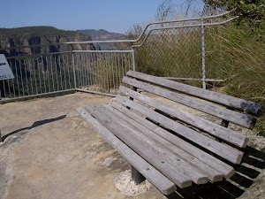
Barrow Lookout, Blue Mountains National Park, looks down to Govetts Leap falls and across the Grose Valley. The lookout is fenced and has a bench seat to rest.
(9.47km) Barrow Lookout → Int. Braeside Service Trail and Braeside Picnic Area
1.3 km
23 mins
62m
-10m
Hard track
Turn around: From Barrow Lookout, this walk heads down the stairs towards Bridal Veil Falls and the creek in the valley. The walk soon comes to a signposted intersection, above cement stepping stones in the creek.
Veer left: From the intersection, this walk follows the ‘Braeside Walk’ sign, up the stream, along the rocky track. The walk leads approximately 100m, to then go down to the creek. The stepping stones are followed up stream to a set of stairs. This walk climbs the stairs and continues south-west for approximately 100m to find some overhead power lines.
The walk continues upstream, passing an overgrown track on the left (which heads underneath power lines on the left to join up with a management trail above on the hill). This track is passed, as the brook is followed for approximately 100m, passing some large boulders on the right as the track continues approximately 500m to the Braeside Picnic Area.
Continue straight: From the weir and the barbeque, this walk heads up the hill, keeping the weir on the right of the track, soon reaching the stepping stones. The track tends right across the creek via the stepping stones. From the creek, this walk heads up the steps to the signposted intersection on the management trail.
Braeside Picnic Area
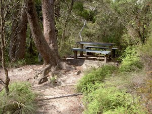
Braeside Picnic Area, Blue Mountains National Park, is a small picnic area on the southern end of the Braeside walking track. The picnic area has a bench table and stone barbeque. The picnic area is situated next to a small weir and waterfall amongst the ferns.
(10.74km) Int. Braeside Service Trail and Braeside Picnic Area → Int. Pope’s Glen Trk and Dell St
2.8 km
53 mins
124m
-62m
Moderate track
Veer right: From the intersection, this walk heads up the hill past a car park area on the right, and up to the intersection of the management trails.
Continue straight: From the intersection, this walk heads up the hill passing a driveway on the left. The walk heads up the hill towards the white house at the top of the hill, to turn left (west) onto Braeside St, keeping the white house behind to the right. This walk continues up the street to the intersection with Boreas St.
Turn right: From the intersection, this walk heads north up Boreas St to turn left onto Govetts Leap Road. This walk continues along Govetts Leap Rd to the intersection with Prince Edward St.
Turn right: From the intersection, this walk follows the ‘Prince Edward St’ and caravan (symbol) signs, past the pink cottage on the left. The walk continues along the road, passing Memorial Park and Swimming Pool on the left before tending right to the intersection with Gipps Lane (which is on the left).
Continue straight: From the intersection, this walk heads up the road, leaving Gipps St behind on the left and passing a wooden house (also on the left). The walk passes Cleopatra St on the left before coming to the signposted intersection with the Pope’s Glen track on the right, near 49 Dell St.
Maps for the Popes Glen, Pulpit Rock, Govetts Leap and Braeside Walk walk
You can download the PDF for this walk to print a map.
These maps below cover the walk and the wider area around the walk, they are worth carrying for safety reasons.
| Katoomba | 1:25 000 Map Series | 89301S KATOOMBA | NSW-89301S |
| Mount Wilson | 1:25 000 Map Series | 89301N MOUNT WILSON | NSW-89301N |
| Katoomba | 1:100 000 Map Series | 8930 KATOOMBA | 8930 |
Cross sectional view of the Popes Glen, Pulpit Rock, Govetts Leap and Braeside Walk bushwalking track
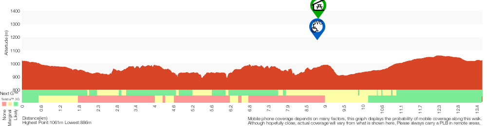
Analysis and summary of the altitude variation on the Popes Glen, Pulpit Rock, Govetts Leap and Braeside Walk
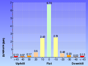
Overview of this walks grade – based on the AS 2156.1 – 2001
Under this standard, a walk is graded based on the most difficult section of the walk.
| Length | 13.6 km | ||
| Time | 8 hrs | ||
| . | |||
| Grade 4/6 Hard track |
AS 2156.1 | Gradient | Very steep (4/6) |
| Quality of track | Rough track, where fallen trees and other obstacles are likely (4/6) | ||
| Signs | Directional signs along the way (3/6) | ||
| Experience Required | No experience required (1/6) | ||
| Weather | Weather generally has little impact on safety (1/6) | ||
| Infrastructure | Limited facilities, not all cliffs are fenced (3/6) |
Some more details of this walks Grading
Here is a bit more details explaining grading looking at sections of the walk
Gradient
11km of this walk has short steep hills and another 1.5km is flat with no steps. Whilst another 890m is very steep and the remaining 390m has gentle hills with occasional steps.
Quality of track
9km of this walk follows a formed track, with some branches and other obstacles and another 1.8km follows a smooth and hardened path. Whilst another 1.2km follows a clear and well formed track or trail and the remaining 1.1km follows a rough track, where fallen trees and other obstacles are likely.
Signs
Around 11km of this walk has directional signs at most intersection, whilst the remaining 3.1km is clearly signposted.
Experience Required
This whole walk, 14km requires no previous bushwalking experience.
weather
This whole walk, 14km is not usually affected by severe weather events (that would unexpectedly impact safety and navigation).
Infrastructure
Around 11km of this walk has limited facilities (such as not all cliffs fenced), whilst the remaining 2.9km is close to useful facilities (such as fenced cliffs and seats).
Similar walks
A list of walks that share part of the track with the Popes Glen, Pulpit Rock, Govetts Leap and Braeside Walk walk.
630 m Return
30 mins
Moderate track
748 m Return
30 mins
Moderate track
816 m Return
45 mins
Hard track
1.2 km Return
1 hr 45 mins
Hard track
1.4 km Return
1 Hr
Hard track
2.5 km Return
1 Hr
Hard track
3.2 km One way
1 hr 45 mins
Hard track
3.8 km One way
2 hrs 30 mins
Hard track
4.2 km One way
2 hrs 30 mins
Hard track
6.6 km One way
4 hrs 15 mins
Hard track
8.7 km Circuit
3 hrs 30 mins
Hard track
8.7 km Circuit
4 hrs 30 mins
Hard track
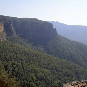
9.3 km Circuit
4 hrs 30 mins
Hard track
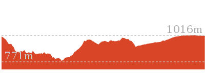
10.7 km Circuit
6 hrs 30 mins
Hard track
12.8 km One way
2 Days
Hard track
15.6 km Circuit
7 hrs 30 mins
Hard track
16.5 km One way
2 Days
Hard track
17.6 km One way
9 hrs
Experienced only
18.2 km Circuit
8 hrs 30 mins
Hard track
22.2 km One way
2 Days
Experienced only
22.5 km One way
3 Days
Experienced only
24.1 km Circuit
2 Days
Hard track
Other Nearby walks
A list of walks that start near the Popes Glen, Pulpit Rock, Govetts Leap and Braeside Walk walk.
2.4 km Circuit
1 Hr
Very easy
1.9 km One way
45 mins
Very easy
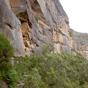
3.1 km One way
2 hrs
Hard track
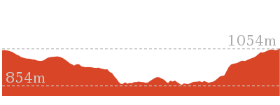
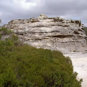
1.6 km Return
1 Hr
Moderate track
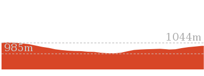
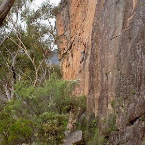
2.3 km One way
1 hr 15 mins
Moderate track
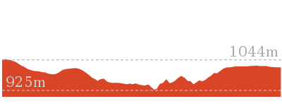
588 m Return
30 mins
Very easy
1.4 km Circuit
45 mins
Moderate track
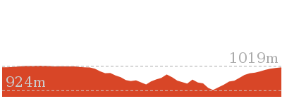
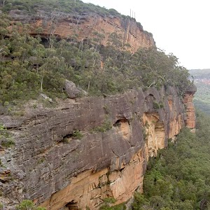
5.4 km Circuit
3 hrs 30 mins
Hard track
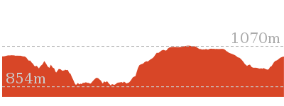
7.6 km Return
3 hrs 30 mins
Hard track
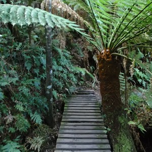
5.4 km Circuit
3 hrs 30 mins
Hard track
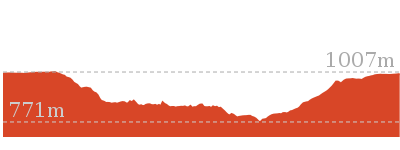
3.1 km Return
2 hrs
Hard track
6.4 km Circuit
4 hrs
Very experienced only
Plan your trip to and from the walk here
The Popes Glen, Pulpit Rock, Govetts Leap and Braeside Walk walk starts and ends at the Int. Popes Glen Trk and Dell St (gps: -33.63241, 150.29411)
Your transport options to Int. Popes Glen Trk and Dell St are by;
![]() Train. (get details)
Train. (get details)
![]() Bus. (get details)
Bus. (get details)
![]() Car. There is free parking available.
Car. There is free parking available.
(get details)
Short URL = http://wild.tl/pgprglabw
Gallery images
There are other downloads I am still working on.
You will probably need to login to access these — still all free.
* KML (google earth file)
* GPX (GPS file)
Special Maps/ brochures
* A3 topo maps
* PDF with Lands Topo map base
* PDF with arial image (and map overlay)
I wanted to get the main site live first, this extra stuff will come in time.
Happy walking
Matt 🙂
Govetts Leap Descent
And Walk
Govetts Leap Descent

1 hr 45 mins
1.2 km Return
366 m
Hard track
Starting with spectacular views of Govetts Leap from Govetts Leap Lookout, this walk sweeps down to the base of the falls. The walk down is showered by drips from the moist moss hanging off the cliffs above. A spectacular track with equally awesome views across the Grose Valley, the walk is steep and gives a great sense of the height of surrounding cliffs. (‘leap’ is a Scots dialect word for cataract or waterfall)
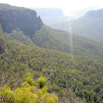
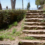


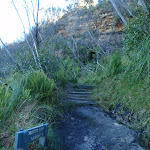
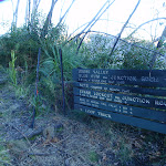

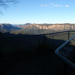

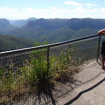

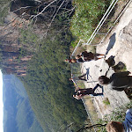
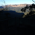

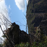
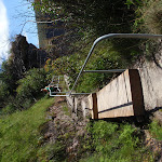
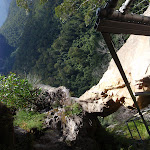


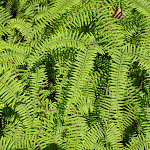
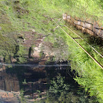
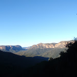
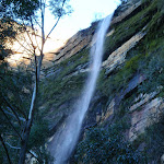

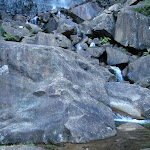
Govetts Leap Lookout
Govetts Leap Lookout is named after the first European man to have enjoyed this view, William Govett, as an assistant surveyor in June 1831. Govetts Leap Lookout offers wonderful views over the Grose Valley and the spectacular Bridal Falls. The word `leap` is an old Scottish word meaning waterfall. The lookout is easily accessed from the car park[3], there are also toilets[4]
and picnic shelters[5]
nearby.
(0km) Govetts Leap Lookout → Bottom of Govetts Leap falls
610 m
42 mins
61m
-305m
Hard track
From Govetts Leap Lookout, this walk heads down the stairs at the edge of the lookout, keeping the valley to the right. The walk then crosses a grassed area to a well-signposted intersection on the edge of the tree line.
Turn right: From the intersection, this walk winds down the hill, tending right at first. The walk then zigzags down to a sign-marked intersection.
Continue straight: From the intersection, this walk heads down the stairs towards Govetts Leap Falls. The track soon passes two lookouts as it winds steeply down the cliff line, passing through the rock on a metal staircase. The walk zigzags its way steeply down the walls of rock covered in moss, ferns and grasses as it follows the railed paths and steps down to the base of Govetts Leap Falls.
Govetts Leap (falls)
Govetts Leap, is a waterfall in the Blue Mountains National Park. The fall is fed by Govetts Leap Brook which runs over the cliff into the Grose Valley. The falls are best viewed from Govetts Leap and Barrow Lookouts. Leap is a scots dialect word for cataract or waterfall.
Maps for the Govetts Leap Descent walk
You can download the PDF for this walk to print a map.
These maps below cover the walk and the wider area around the walk, they are worth carrying for safety reasons.
| Katoomba | 1:25 000 Map Series | 89301S KATOOMBA | NSW-89301S |
| Katoomba | 1:100 000 Map Series | 8930 KATOOMBA | 8930 |
Cross sectional view of the Govetts Leap Descent bushwalking track
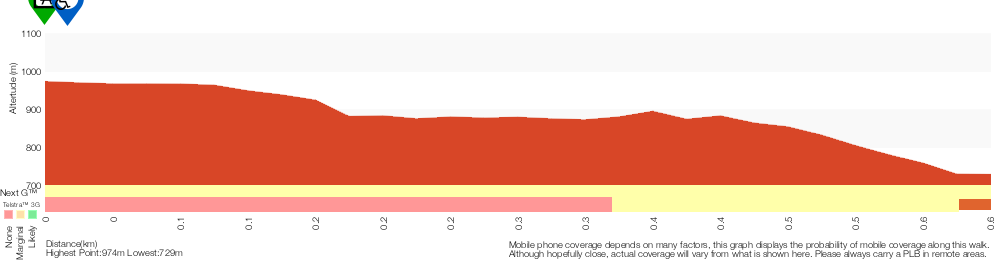
Analysis and summary of the altitude variation on the Govetts Leap Descent
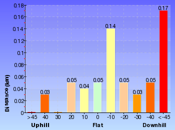
Overview of this walks grade – based on the AS 2156.1 – 2001
Under this standard, a walk is graded based on the most difficult section of the walk.
| Length | 1.2 km | ||
| Time | 1 hr 45 mins | ||
| . | |||
| Grade 4/6 Hard track |
AS 2156.1 | Gradient | Very steep (4/6) |
| Quality of track | Rough track, where fallen trees and other obstacles are likely (4/6) | ||
| Signs | Directional signs along the way (3/6) | ||
| Experience Required | Some bushwalking experience recommended (3/6) | ||
| Weather | Weather generally has little impact on safety (1/6) | ||
| Infrastructure | Limited facilities, not all cliffs are fenced (3/6) |
Some more details of this walks Grading
Here is a bit more details explaining grading looking at sections of the walk
Gradient
Around 570m of this walk is very steep, whilst the remaining 35m has gentle hills with occasional steps.
Quality of track
430m of this walk follows a formed track, with some branches and other obstacles and another 140m follows a rough track, where fallen trees and other obstacles are likely. The remaining (35m) follows a clear and well formed track or trail.
Signs
Around 570m of this walk has directional signs at most intersection, whilst the remaining 35m is clearly signposted.
Experience Required
Around 430m of this walk requires some bushwalking experience, whilst the remaining 180m requires no previous bushwalking experience.
weather
This whole walk, 610m is not usually affected by severe weather events (that would unexpectedly impact safety and navigation).
Infrastructure
Around 430m of this walk has limited facilities (such as not all cliffs fenced), whilst the remaining 180m is close to useful facilities (such as fenced cliffs and seats).
Similar walks
A list of walks that share part of the track with the Govetts Leap Descent walk.
3.8 km One way
2 hrs 30 mins
Hard track
4.2 km One way
2 hrs 30 mins
Hard track
6.6 km One way
4 hrs 15 mins
Hard track
8.7 km Circuit
3 hrs 30 mins
Hard track
8.7 km Circuit
4 hrs 30 mins
Hard track
10.7 km Circuit
6 hrs 30 mins
Hard track
12.8 km One way
2 Days
Hard track
13.6 km Circuit
8 hrs
Hard track
15.6 km Circuit
7 hrs 30 mins
Hard track
16.5 km One way
2 Days
Hard track
17.6 km One way
9 hrs
Experienced only
18.2 km Circuit
8 hrs 30 mins
Hard track
22.2 km One way
2 Days
Experienced only
22.5 km One way
3 Days
Experienced only
24.1 km Circuit
2 Days
Hard track
Other Nearby walks
A list of walks that start near the Govetts Leap Descent walk.
3.2 km One way
1 hr 45 mins
Hard track
1.4 km Return
1 Hr
Hard track
588 m Return
30 mins
Very easy
2.4 km Circuit
1 Hr
Very easy
1.9 km One way
45 mins
Very easy
2.5 km Return
1 Hr
Hard track
816 m Return
45 mins
Hard track
748 m Return
30 mins
Moderate track
630 m Return
30 mins
Moderate track
3.1 km One way
2 hrs
Hard track
1.6 km Return
1 Hr
Moderate track
2.3 km One way
1 hr 15 mins
Moderate track
Plan your trip to and from the walk here
The Govetts Leap Descent walk starts and ends at the Govetts Leap Lookout (gps: -33.627976, 150.31134)
Your transport options to Govetts Leap Lookout are by;
![]() Bus. (get details)
Bus. (get details)
![]() Car. There is free parking available.
Car. There is free parking available.
(get details)
Short URL = http://wild.tl/gltbvf
Gallery images
There are other downloads I am still working on.
You will probably need to login to access these — still all free.
* KML (google earth file)
* GPX (GPS file)
Special Maps/ brochures
* A3 topo maps
* PDF with Lands Topo map base
* PDF with arial image (and map overlay)
I wanted to get the main site live first, this extra stuff will come in time.
Happy walking
Matt 🙂
Walls Ledge, Porters Pass, Centennial Glen Circuit

3 hrs 30 mins
5.4 km Circuit
473 m
Hard track
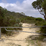

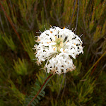
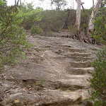

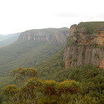

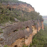
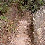


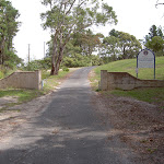
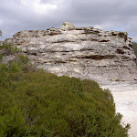

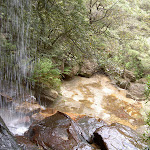

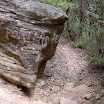
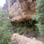
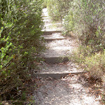
(0km) Centennial Glen Rd Carpark → Int. Walls Ledge Track and Centennial Glen Rd Carpark Trk
1.1 km
25 mins
3m
-70m
Moderate track
From the car park, this walk heads to the service trail gate parallel with the road (approximately in line with the end of the grassy median strip) and then onto the trail behind. The track passes through the heath for a while until it nears the cliff edge and narrows. The walk continues around the hill through the heath for some time to then begin a descent over a rocky surface with cut-in stairs. The track winds right, keeping with the cliffline while looking out to the valley on the left. Be mindful of climbers and falling objects along these cliffs. The cliffline disappears behind scrub as the track reaches a man-made basin filled by drips from the cliff roof above. The track rounds out of this glen to climb up the hill, through heath to the signposted intersection.
(1.11km) Int. Walls Ledge Track and Centennial Glen Rd Carpark Trk → Centennial Glen Waterfall Trk
130 m
5 mins
11m
-18m
Moderate track
Veer left: From the intersection, this walk keeps the valley on the left as the track soon meets the cliffs, coming to the intersection, where there is a rock with direction arrows painted on it.
Veer left: From the painted rock, this walk follows the ‘Porters Pass’ arrow[1], heading down the hill with views of Kanimbla Valley to the left. The hill tends right for approximately 50m before coming to an unsignposted intersection above stairs.
Turn left: From the intersection, this walk heads down the stairs (cut into the rock), soon passing under a railing bar. The walk comes to a landing in the staircase, just above a creek coming out of the canyon.
(1.24km) Centennial Glen Waterfall Trk → Centennial Glen Waterfall
30 m
1 mins
7m
0m
Hard track
Turn sharp right: From the stairs, this walk heads away from the landing along a less-defined path, into the canyon. The track leads to a rock ledge which follows the creek (below on the left) for approximately 50m to the pool before a waterfall. (Alternatively, a wetter track follows the cliff for approximately 30m to drop to the left, into the creek, and continue to the waterfall). At the end of this side trip, retrace your steps back to the main walk then Turn right.
(1.24km) Centennial Glen Waterfall Trk → Porters Pass
1.3 km
49 mins
177m
-207m
Hard track
Continue straight: From the landing, this walk follows the canyon creek (on the right) downstream, taking the railed stairs down the canyon wall. The walk then crosses through large rocks to the cliff on the other side of the pass. The track then winds along the bottom of the cliffline, which it keeps on the right. After approximately 1km, the walk heads into a pass in the cliffs then leaves the cliffline, crossing a few rocks with railings over them to climb up the side of Porters Pass. The track passes between two large trees and comes to a creek (before some stairs).
(2.56km) Porters Pass → Burton Ave
610 m
18 mins
157m
-8m
Hard track
Continue straight: From the creek, this walk leads up the steep rock steps, away from the rock overhang in the cliffs. The walk heads out of the gorge following a few flights of stairs, leading to an area above the gorge with views of the Kanimbla Valley (to the right). The track meanders up the hill for approximately 100m, coming to a few tracks which all lead up the hill to the same rocky outcrop. The walk follows any of these tracks up the hill, until above the large rocky outcrop.
Continue straight: From the rocky outcrop, this walk leads up the stairs, with the valley behind. After approximately 50m, the walk comes to an unsigned intersection.
Continue straight: From the intersection, this walk heads down the hill along the track, with views of the valley to the right. The walk heads down the steps then levels out briefly before continuing up the hill to the end of Burton Ave.
(3.18km) End of Burton St → Blue Mountains Christian School Gate
440 m
9 mins
17m
-3m
Very easy
Continue straight: From the end of Burton Ave, this walk heads up the hill, following the power lines to Kanimbla Rd. At Kanimbla Rd, the walk turns right and continues to the gates of Blue Mountains Christian School (cnr Thirroul Ave).
(3.62km) Blue Mountains Christian School Gate → Fort Rock
770 m
18 mins
12m
-55m
Moderate track
Continue straight: From the front entrance of Blue Mountains Christian School, this walk passes through the school gate, keeping the playing field to the right. The walk heads toward toward the power pole, down the bush track on the left. The track heads down a slight hill shaded by some large pine trees, then rises up to pass by a playground. The walk then does down into an area of heath, and after approximately 300m, comes to the clearing below Fort Rock.
Fort Rock
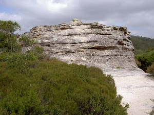
Fort Rock, Blue Mountains National Park, is a formation of rock that sits alone in solitude above Centennial Glen valley. It looks very similar to a rook chess piece. From the top of the rock, there are stunning views over the Megalong Valley and Kanimbla Valley.
(4.39km) Fort Rock → Cliff West of Fort Rock
210 m
5 mins
0m
-46m
Experienced only
Turn right: From the clearing below Fort Rock, this walk heads towards the views of the valley. The track continues through the heath for approximately 100m along the most worn of the tracks to the rocky outcrop on the edge of the cliff. At the end of this side trip, retrace your steps back to the main walk then Veer right.
(4.39km) Fort Rock → Int. Fort Rock Trk and Centennial Pass Trk
130 m
4 mins
0m
-20m
Moderate track
Veer left: From Fort Rock, this walk heads down the hill towards the rocky outcrops in the valley below and the houses above. The track descends steps through the thick heath vegetation for approximately 50m. The walk then comes to a rocky outcrop, and crosses this to where ‘Porters Pass’ and ‘Fort Rock’ have been hand-painted on the rock.
(4.52km) Int. Fort Rock Trk and Centennial Pass Trk → Int. Walls Ledge Track and Centennial Pass Trk
540 m
18 mins
23m
-87m
Moderate track
Veer right: From the rocky surface, this walk follows the arrow to ‘Porters Pass’ down the hill. The track heads down through thick heath to come to a set of stairs in a narrow pass. The walk leads down the stairs to a clearer area, lined with cliffs. The track keeps with the cliffs on the left to wind into Centennial Glen with a waterfall over the track. The track continues to follow the cliffs on the left to a boulder marked in white paint ‘Porters Pass’.
Veer left: From the intersection, this walk follows the clearing below the cliffs (left of the track) for approximately 50m. The track comes to an intersection marked by two rocks, with ‘Centennial Glen’ and ‘Porters Pass’ painted on them.
Veer left: From the intersection, this walk follows the clearing below the cliffs (left of the track) for approximately 50m. The track comes to an intersection marked by two rocks, with ‘Centennial Glen’ and ‘Porters Pass’ painted on them.
(5.06km) Int. Walls Ledge Track and Centennial Pass Trk → Centennial Glen Rd Carpark
310 m
12 mins
73m
-2m
Moderate track
Veer left: From the intersection, this walk keeps the valley on the right as the track soon leaves the cliffs to meander around the hillside, coming to the steps on the left.
Turn left: From the intersection, this walk heads up the stairs that round the rocky outcrop (on the left). The walk winds up to look out over the Kanimbla Valley before continuing up through the heath for a short time to the car park.
Turn left: From the intersection, this walk heads up the stairs that round the rocky outcrop (on the left). The walk winds up to look out over the Kanimbla Valley before continuing up through the heath for a short time to the car park.
Maps for the Walls Ledge, Porters Pass, Centennial Glen Circuit walk
You can download the PDF for this walk to print a map.
These maps below cover the walk and the wider area around the walk, they are worth carrying for safety reasons.
| Katoomba | 1:25 000 Map Series | 89301S KATOOMBA | NSW-89301S |
| Katoomba | 1:100 000 Map Series | 8930 KATOOMBA | 8930 |
Cross sectional view of the Walls Ledge, Porters Pass, Centennial Glen Circuit bushwalking track
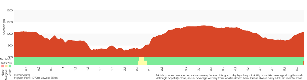
Analysis and summary of the altitude variation on the Walls Ledge, Porters Pass, Centennial Glen Circuit
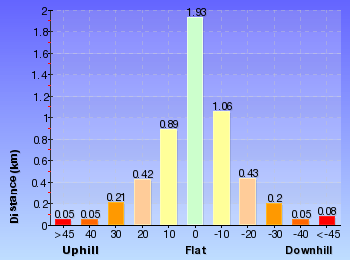
Overview of this walks grade – based on the AS 2156.1 – 2001
Under this standard, a walk is graded based on the most difficult section of the walk.
| Length | 5.4 km | ||
| Time | 3 hrs 30 mins | ||
| . | |||
| Grade 4/6 Hard track |
AS 2156.1 | Gradient | Short steep hills (3/6) |
| Quality of track | Rough track, where fallen trees and other obstacles are likely (4/6) | ||
| Signs | Minimal directional signs (4/6) | ||
| Experience Required | Some bushwalking experience recommended (3/6) | ||
| Weather | Weather generally has little impact on safety (1/6) | ||
| Infrastructure | Limited facilities (such as cliffs not fenced, significant creeks not bridged) (4/6) |
Some more details of this walks Grading
Here is a bit more details explaining grading looking at sections of the walk
Gradient
4.9km of this walk has short steep hills and another 440m is flat with no steps. The remaining (65m) has gentle hills with occasional steps.
Quality of track
3.2km of this walk follows a formed track, with some branches and other obstacles and another 1.8km follows a rough track, where fallen trees and other obstacles are likely. The remaining (440m) follows a smooth and hardened path.
Signs
3.5km of this walk has directional signs at most intersection and another 1.3km has minimal directional signs. The remaining (530m) is clearly signposted.
Experience Required
Around 4km of this walk requires no previous bushwalking experience, whilst the remaining 1.3km requires some bushwalking experience.
weather
This whole walk, 5km is not usually affected by severe weather events (that would unexpectedly impact safety and navigation).
Infrastructure
3.5km of this walk has limited facilities (such as not all cliffs fenced) and another 1.3km has limited facilities (such as cliffs not fenced, significant creeks not bridged). The remaining (530m) is close to useful facilities (such as fenced cliffs and seats).
Similar walks
A list of walks that share part of the track with the Walls Ledge, Porters Pass, Centennial Glen Circuit walk.
1.4 km Circuit
45 mins
Moderate track
1.6 km Return
1 Hr
Moderate track
2.3 km One way
1 hr 15 mins
Moderate track
3.1 km One way
2 hrs
Hard track
Other Nearby walks
A list of walks that start near the Walls Ledge, Porters Pass, Centennial Glen Circuit walk.
8.7 km Circuit
3 hrs 30 mins
Hard track
18.2 km Circuit
8 hrs 30 mins
Hard track
15.6 km Circuit
7 hrs 30 mins
Hard track
8.7 km Circuit
4 hrs 30 mins
Hard track
24.1 km Circuit
2 Days
Hard track
13.6 km Circuit
8 hrs
Hard track
2.5 km Return
1 Hr
Hard track
2.4 km Circuit
1 Hr
Very easy
1.9 km One way
45 mins
Very easy
588 m Return
30 mins
Very easy
1.2 km Return
1 hr 45 mins
Hard track
3.8 km One way
2 hrs 30 mins
Hard track
Plan your trip to and from the walk here
The Walls Ledge, Porters Pass, Centennial Glen Circuit walk starts and ends at the Centennial Glen Rd Carpark (gps: -33.6389, 150.27543)
Your transport options to Centennial Glen Rd Carpark are by;
![]() Train. (get details)
Train. (get details)
![]() Bus. (get details)
Bus. (get details)
![]() Car. There is free parking available.
Car. There is free parking available.
(get details)
Short URL = http://wild.tl/wlppcgc
Gallery images
There are other downloads I am still working on.
You will probably need to login to access these — still all free.
* KML (google earth file)
* GPX (GPS file)
Special Maps/ brochures
* A3 topo maps
* PDF with Lands Topo map base
* PDF with arial image (and map overlay)
I wanted to get the main site live first, this extra stuff will come in time.
Happy walking
Matt 🙂
Victoria Falls Lookout to Blue Gum Forest

8 hrs
13.8 km One way
1102 m
Experienced only
This long day-walk follows a remote track down from Victoria Falls lookout, passing the waterfall, and into the Grose Valley, to the famous Blue Gum Forest, a scenic and historic highlight of this area. From the Blue Gum Forest, the walk climbs steeply to finish at Perry’s Lookdown. You will need to organise a car shuttle, or a taxi for this walk.* This walk passes through very remote areas and sections have no visible track. At least one person in your group should have training and experience in off track walking and navigation. Even with these notes and a GPS these extra skills and equipment are required.

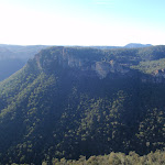
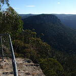
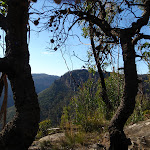
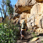
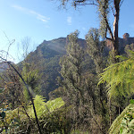


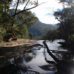


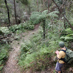
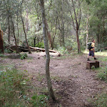

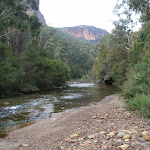
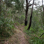

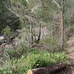
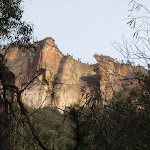


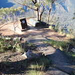
(0km) Victoria Falls Rd car park → Victoria Falls Lookout
100 m
2 mins
0m
-15m
Moderate track
From the car park, this walk follows the sign to ‘Grose Valley Lookout’ down the hill. The walk then winds down some steps for approximately 50m to a lookout.
Victoria Falls Lookout
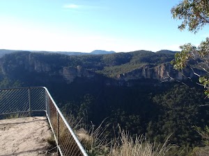
Victoria Falls Lookout, Blue Mountains NP, has an easterly aspect over the Grose Valley. Although the lookout is named after the wonderful Victoria Falls, there are no views of the falls from this lookout.
(0.1km) Victoria Falls Lookout → Int. Victoria Creek Cascades and Victoria Falls Tracks
1.3 km
39 mins
24m
-358m
Hard track
Continue straight: From the lookout, this walk heads past the ‘Victoria Falls’ sign, down the hill. It leads across the hill for a short while before turning right and following the steps downhill for approximately 100m. The track then tends left, steeply down through a rocky outcrop, then continues winding across the hill under rocky outcrops (on the right). The track winds left, down through the rock again, to steeply zigzag down the hill for some time, moving away from the rocky outcrop, into ferns and more grassy undergrowth. The track heads steeply down towards the sound of the cascades at the signposted intersection.
(1.38km) Int. Victoria Creek Cascades and Victoria Falls Tracks → Victoria Creek Cascades
90 m
3 mins
14m
0m
Hard track
Veer right: From the intersection, this walk follows the sign to ‘Cascades’, heading towards the noise of the falling water. It follows the hillside through the rainforest vegetation to the creek bank. The track then continues over the slippery rocks to the bottom of the falls. At the end of this side trip, retrace your steps back to the main walk then Veer right.
Victoria Cascades
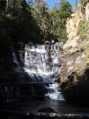
Victoria Cascades, Blue Mountains NP, is a shorter run of water than the larger Victoria Falls. These cascades rush over a slope of rock to continue down to Victoria Falls. The cascades, made by Victoria Creek, are worth a look on your way down to Victoria Falls. However, on a a trip up from Victoria Falls, these smaller cascades may be somewhat overshadowed by the larger falls.
(1.38km) Int. Victoria Creek Cascades and Victoria Falls Tracks → Int. Top of Falls and Victoria Creek Tracks
20 m
0m
-2m
Moderate track
Turn left: From the intersection, this walk follows the sign to ‘Burra Korain Flat’, heading down the stairs for a short distance to another signposted intersection.
(1.39km) Int. Top of Falls and Victoria Creek Tracks → Top of Falls
20 m
1 mins
1m
-1m
Hard track
Turn sharp right: From the intersection, this walk follows the ‘Top of Falls’ sign, down the hill to Victoria Creek. The track then turns left, descending steeply on some rocks. This walk continues downstream along a rockshelf to the top of Victoria Falls. At the end of this side trip, retrace your steps back to the main walk then Continue straight.
(1.39km) Int. Top of Falls and Victoria Creek Tracks → Int. Bottom of Falls and Victoria Creek Tracks
100 m
2 mins
0m
-19m
Hard track
Continue straight: From the intersection, this walk follows the sign to ‘Burra Korain Flats’ heading up the hill and then down to a railing, overlooking the Victoria Falls. The track then winds down the slippery hillside, descending to an intersection in front of a large, mossy rock.
(1.49km) Int. Bottom of Falls and Victoria Creek Tracks → Victoria Falls
50 m
2 mins
13m
0m
Hard track
Veer right: From the intersection, the track follows the hillside towards the sound of a waterfall, keeping the creek some distance below to your left. The track soon opens out onto the cliff of the waterfall. The track then swings around the right-hand side to go up the scree slope to venture behind the waterfall. At the end of this side trip, retrace your steps back to the main walk then Veer right.
Victoria Falls
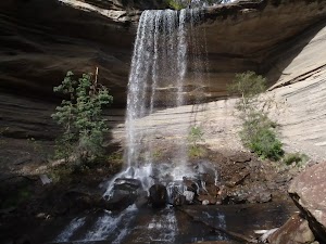
Victoria Falls, Blue Mountains NP, is a large waterfall dropping over a grey rock overhang. The cascade is produced by Victoria Creek dropping over the approximately-15m cliffs. A scree slope leads up behind the falls, and below the falls the rocks are very slippery. These falls are well worth a visit, with the great views from the top of the falls, and the accessibility of the bottom of the falls, making a great trip.
(1.49km) Int. Bottom of Falls and Victoria Creek Tracks → Burra Korain Flat Camping Area
1.3 km
29 mins
22m
-126m
Hard track
Turn left: From the intersection, this walk follows the track downhill towards the creek, keeping the creek to you right, so soon come to a clearing beside the creek. Here the walk crosses the creek to find a sign pointing to ‘Burra Korain Flat’ (visible before crossing the creek). (This creek may be impassable after rain). The walk turns left to follow the ‘Burra Korain Flat’ sign downhill, keeping the creek to your left for over 1km. The track winds and undulating through ferns and rocky outcrops, to open out into the Burra Korain Flat Camping Area, which is signposted.
Burra Korain Flat Camping Area
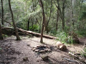
Burra Korain Flat Camping Area, Blue Mountains NP, is a small clearing between the Victoria Creek and Grose River. The campsite is well signposted and has nice sitting logs and plenty of space for a few tents. Water can be accessed from either river or creek but should be treated before use.
(2.84km) Burra Korain Flat Camping Area → Blue Gum Forest intersection
8.8 km
3 hrs 24 mins
422m
-599m
Experienced only
Continue straight: From the campsite, this walk heads down the hill to the creek and then across it. The track continues up through a grassy area to a clearing with a fireplace and BBQ and a sign to ‘Acacia Flat’.
Continue straight: From the camping area, this walk follows the ‘Acacia Flats’ sign down to the creek. The track crosses the creek and continues along the right-hand bank, heading downstream. The track then undulates and winds on the right side of the creek for approximately 3km in a south-easterly direction. The track crosses a number of creeks, and continues undulating along the south side of the Grose River to an intersection, with a sign pointing back to Burra Korain.
Continue straight: From the intersection, this walk follows the sign to ‘Acacia Flats’[1], keeping the creek below on the left. The track continues for approximately 500m, undulating across the steep hillside. The terrain then begins to flatten out as the track leads onto a creek flat area. After a short while, a clearing with a fireplace is passed, on your right. The track continues to undulate along the hillside, with the creek to the left, for approximately 2km, to an area where the creek flats broaden. The track passes some more clearings with fire places, coming to a sign marked ‘Blue Gum Forest’. The track passes this sign and continues for approximately 500m to a well-signed intersection.
Blue Gum Forest
Blue Gum Forest, Blue Mountains NP, is a large stand of Eucalyptus deanei trees on the junction of the Grose River and Govetts Creek. The magnificent trees stand tall on the flats with low vegetation beneath. The trees of Blue Gum Forest represent the protection efforts of Myles Dunphy, who lead a group to raise the 130 pounds required to buy the Blue Gum Forest – quite a sum in 1931 during the depression – and save it from being cleared. The group were successful and the Blue Gum Forest is now protected within the Blue Mountains National Park. More info.
(11.63km) Blue Gum Forest intersection → Int. Perry’s and Dockers Lookout Tracks
2 km
1 hr 31 mins
603m
-22m
Hard track
Turn right: From the intersection, the walk follows the ‘Perrys Lookdown Track’ sign up the hill. The track heads uphill out of Blue Gum Forest, before tending right to more steeply climb the hill. As the track tends right, it heads up to the spur. When the track joins the spur, it turns left and heads up and continues winding for some time. The track continues up the spur to the cliffline, where it meets a set of steps and handrails. The walk climbs up large, steep steps, winding up through the pass to a memorial lookout at the top of the cliff.
Continue straight: From Memorial Lookout, the walk climbs the stairs, keeping the valley on the right, and then contours left around the hill. The track descends slightly before crossing a bridge, and then turns right before leading up the steps to the signposted intersection.
Continue straight: From Memorial Lookout, the walk climbs the stairs, keeping the valley on the right, and then contours left around the hill. The track descends slightly before crossing a bridge, and then turns right before leading up the steps to the signposted intersection.
(13.64km) Int. Perry’s and Dockers Lookout Tracks → Dockers Lookout
20 m
1 mins
0m
-13m
Moderate track
Veer right: From the intersection, the walk leads for a short distance down the railed path to the visible lookout area, Docker’s Lookout. At the end of this side trip, retrace your steps back to the main walk then Continue straight.
Dockers Lookout
Dockers Lookout, Blue Mountains NP, has views over the Grose Valley and Blue Gum Forest below. Mt Banks can be seen standing proudly to the north above the valley.
(13.64km) Int. Perry’s and Dockers Lookout Tracks → Perry’s Lookdown
40 m
2 mins
15m
0m
Moderate track
Turn sharp left: From the intersection, the walk follows the railed stairs up the hill for a short time until coming to Perry’s Lookdown – the lookout on the right.
Perry’s Lookdown
Perry’s Lookdown, Blue Mountains NP, has views over the Grose Valley, with Blue Gum Forest nearly directly below and Lockleys Pylon to the south. The lookout is presumably named after Captain William Perry, the Deputy Surveyor General who worked under the leadership of Sir Thomas Mitchell.
(13.68km) Perry’s Lookdown → Perry’s Lookdown car park and camping area
80 m
3 mins
16m
0m
Moderate track
Continue straight: From the lookout, the walk leads up the stairs (leaving the valley behind) to the dirt road and car park.
Perrys Lookdown campground
Perrys Lookdown offers a simple campsite, close to some spectacular lookouts and well located as starting point for longer walks exploring the Grose Valley. There are 5 tent sites and a non-flush toilet, but no water available. This area allows fuel stoves only (no camp fires). The camping area is a short walk from the car park. Limit to one night stay (sites cannot be reserved).
Maps for the Victoria Falls Lookout to Blue Gum Forest walk
You can download the PDF for this walk to print a map.
These maps below cover the walk and the wider area around the walk, they are worth carrying for safety reasons.
| Mount Wilson | 1:25 000 Map Series | 89301N MOUNT WILSON | NSW-89301N |
| Katoomba | 1:100 000 Map Series | 8930 KATOOMBA | 8930 |
Cross sectional view of the Victoria Falls Lookout to Blue Gum Forest bushwalking track
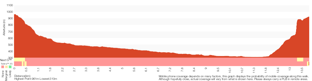
Analysis and summary of the altitude variation on the Victoria Falls Lookout to Blue Gum Forest
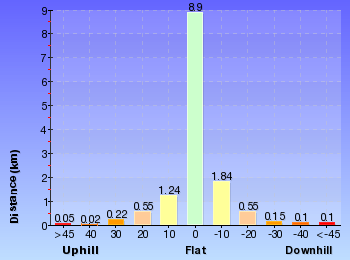
Overview of this walks grade – based on the AS 2156.1 – 2001
Under this standard, a walk is graded based on the most difficult section of the walk.
| Length | 13.8 km | ||
| Time | 8 hrs | ||
| . | |||
| Grade 5/6 Experienced only |
AS 2156.1 | Gradient | Very steep (4/6) |
| Quality of track | Rough unclear track (5/6) | ||
| Signs | Minimal directional signs (4/6) | ||
| Experience Required | Some bushwalking experience recommended (3/6) | ||
| Weather | Weather generally has little impact on safety (1/6) | ||
| Infrastructure | Limited facilities (such as cliffs not fenced, significant creeks not bridged) (4/6) |
Some more details of this walks Grading
Here is a bit more details explaining grading looking at sections of the walk
Gradient
Around 12km of this walk is very steep, whilst the remaining 1.7km has short steep hills.
Quality of track
9km of this walk follows a rough unclear track and another 4.5km follows a rough track, where fallen trees and other obstacles are likely. The remaining (490m) follows a formed track, with some branches and other obstacles.
Signs
5km of this walk has minimal directional signs and another 5km is clearly signposted. The remaining (3.4km) has directional signs at most intersection.
Experience Required
Around 7km of this walk requires no previous bushwalking experience, whilst the remaining 7km requires some bushwalking experience.
weather
This whole walk, 14km is not usually affected by severe weather events (that would unexpectedly impact safety and navigation).
Infrastructure
13km of this walk has limited facilities (such as cliffs not fenced, significant creeks not bridged) and another 390m has limited facilities (such as not all cliffs fenced). The remaining (100m) is close to useful facilities (such as fenced cliffs and seats).
Similar walks
A list of walks that share part of the track with the Victoria Falls Lookout to Blue Gum Forest walk.
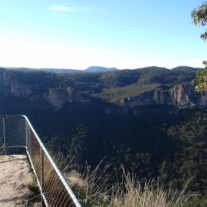
206 m Return
15 mins
Moderate track
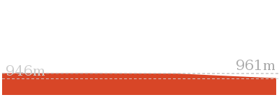
3.1 km Return
2 hrs
Hard track
4.3 km Return
4 hrs
Hard track
8.1 km One way
5 hrs 30 mins
Hard track
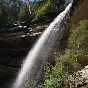
8.9 km One way
2 Days
Experienced only
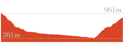
10.4 km One way
5 hrs 30 mins
Experienced only
12.8 km One way
2 Days
Hard track
14 km Return
6 hrs 30 mins
Experienced only
17.6 km One way
9 hrs
Experienced only
22.2 km One way
2 Days
Experienced only
22.5 km One way
3 Days
Experienced only
Other Nearby walks
A list of walks that start near the Victoria Falls Lookout to Blue Gum Forest walk.
5.6 km Return
2 hrs
Hard track
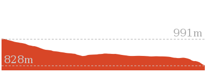
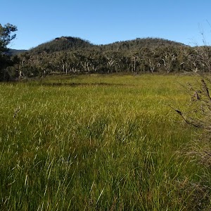
4.2 km Return
1 hr 30 mins
Moderate track
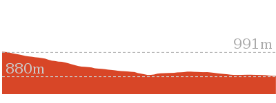
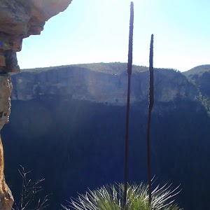
6.4 km Return
2 hrs 30 mins
Very experienced only
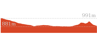
7.6 km Return
3 hrs 30 mins
Hard track
460 m Return
15 mins
Moderate track
400 m Return
15 mins
Easy track
13.6 km Circuit
8 hrs
Hard track
4.2 km One way
2 hrs 30 mins
Hard track
816 m Return
45 mins
Hard track
748 m Return
30 mins
Moderate track
630 m Return
30 mins
Moderate track
6.6 km One way
4 hrs 15 mins
Hard track
Plan your trip to and from the walk here
The Victoria Falls Lookout to Blue Gum Forest walk starts at the Victoria Falls Rd car park (gps: -33.573667, 150.29213)
Your main transport option to Victoria Falls Rd car park is by;
![]() Car. There is free parking available.
Car. There is free parking available.
(get details)
The Victoria Falls Lookout to Blue Gum Forest ends at the Perry’s Lookdown car park and camping area (gps: -33.599394, 150.34602)
Your main transport option to Perry’s Lookdown car park and camping area is by;
![]() Car. There is free parking available.
Car. There is free parking available.
(get details)
Short URL = http://wild.tl/vfltbgf
Gallery images
There are other downloads I am still working on.
You will probably need to login to access these — still all free.
* KML (google earth file)
* GPX (GPS file)
Special Maps/ brochures
* A3 topo maps
* PDF with Lands Topo map base
* PDF with arial image (and map overlay)
I wanted to get the main site live first, this extra stuff will come in time.
Happy walking
Matt 🙂
Comments