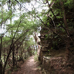
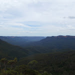
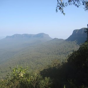
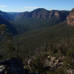
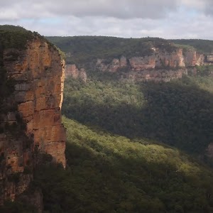
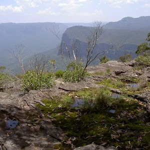
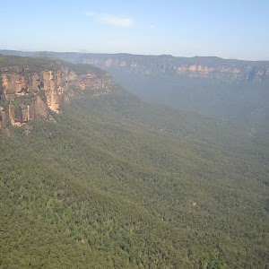
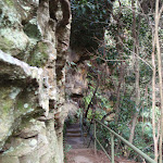
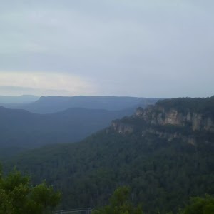
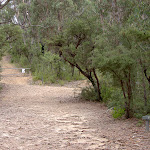
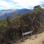
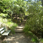
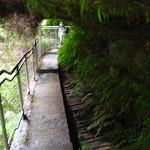
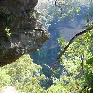
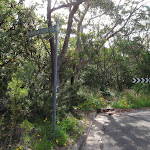
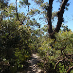
Starting from Solitary Restaurant on Cliff Drive in Leura, this track heads down to the historic Copelands Lookout, providing great views across Jamison Valley. Copelands Lookout is a fairly large lookout with a natural sandstone floor and hand-built sandstone walls. This one way of enjoying great views of the Jamison valley without the hustle and bustle of Echo Point. The walk also offers an optional side trip to the Bridal Veil Lookout, where you can see the falls by the same name.
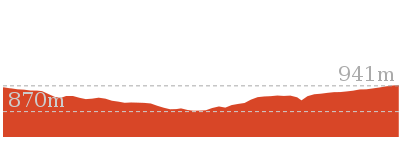
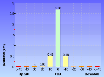
Solitary Kiosk and Restaurant to Copelands Lookout


20 mins
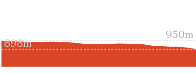
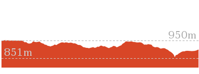
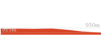
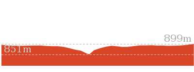
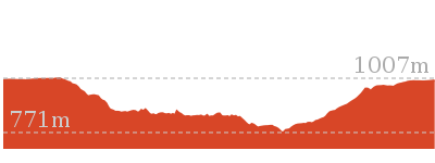
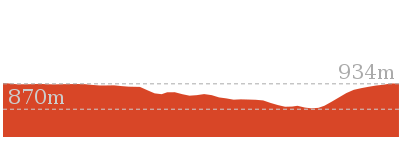
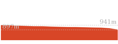
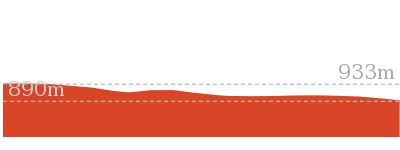
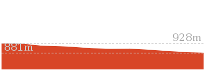
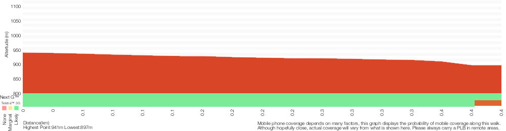
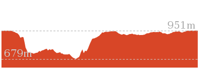
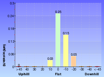
570 m Return

57 m
Moderate track
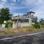


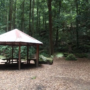
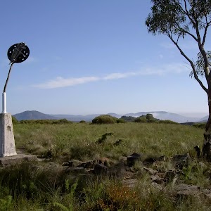
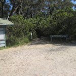
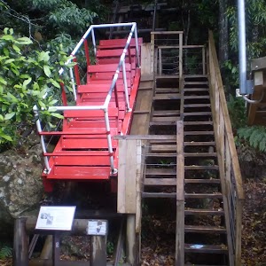
Solitary Kiosk and Restaurant
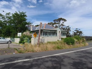
Solitary Restaurant offers fine dining in a heritage-listed building overlooking the beautiful Jamison Valley, as well as housing a kiosk for a more casual lunch. The kiosk is open for lunch 7 days a week, from 10am to 4pm (opens 11am weekdays in winter). The kiosk provides a casual dinning experience, with breakfast foods from $10 and lunches around $15 per dish. The restaurant is open for lunch 7 days from 12-4.30pm, and dinner on Fridays and Saturdays from 6pm. Light lunches start from $14, and dinners from $55 for a mouth-watering 2 course meal. Contact details – 90 Cliff Drive, Leura Falls Ph: 02 4782 1164. More info.
(0km) Int of Cliff Drive and Prince Henry Cliff Walk → Int of Cliff Drive and Fossil Rock Track

50 m
1 mins
3m
-6m
Easy track
From the top of the stairs, this walk follows Cliff Drive down the gentle hill towards the point, passing the restaurant and the sandstone pillar, to the signposted intersection of the Prince Henry Cliff Walk.
(0.05km) Int of Cliff Drive and Fossil Rock Track → Fossil Rock
20 m
1 mins
0m
-10m
Moderate track
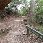
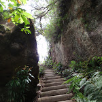
Turn right: From the intersection, the walk follows the Leura Cascades sign down the wooden steps and along the short bush track to Fossil Rock Lookout.
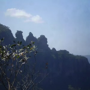
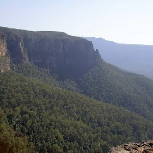
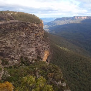
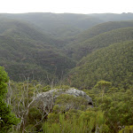
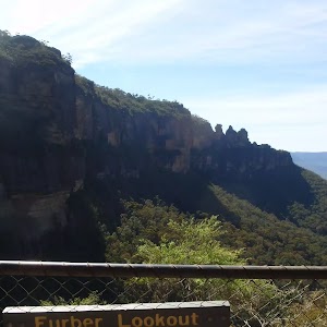
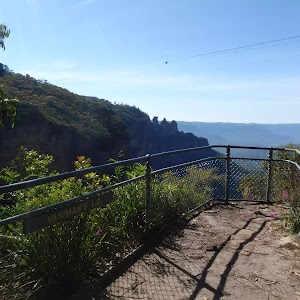
Fossil Rock
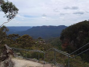
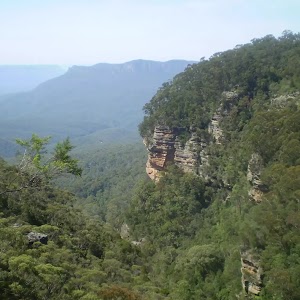
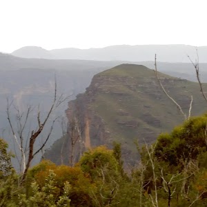
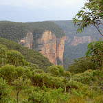
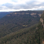
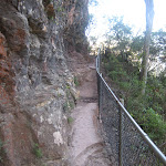
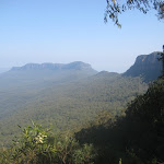
Fossil Rock is a fenced lookout along Prince Henry Cliff Walk, near Katoomba. The lookout is close to Cliff Drive and gives great views along the Jamison Valley and over Mount Solitary, and along the far end of Kings Tableland. The sandstone floor of the lookout is mostly natural and has a few steps cut in it. The rock provides some natural sculptures to enjoy.
(0.08km) Fossil Rock → Int of Prince Henry Cliff Walk and Copelands Lookout Track
40 m
1 mins
0m
-5m
Moderate track
Turn left: Keeping the lookout and the valley to the right, the walk follows the bush track winding down the hill for a short while, before coming to the signposted intersection of the ‘Copelands Lookout’ track.
(0.12km) Int of Prince Henry Cliff Walk and Copelands Lookout Track → Bridal Veil Lookout
60 m
1 mins
1m
-14m
Moderate track
Veer left: From the intersection, the walk follows the track winding along the side of the hill, keeping the cliffs and the valley down to the right, soon coming to the signposted intersection with the track to ‘Bridal Veil Lookout’.
Turn right: From the intersection, the walk follows the ‘Bridal Veil Lookout’ sign along the bush track, heading down the gentle hill through the bush. The walk steps up onto a rock shelf, following it for a short distance before coming to the signposted ‘Bridal Veil Lookout’. At the end of this side trip, retrace your steps back to the main walk then Turn left.
Turn right: From the intersection, the walk follows the ‘Bridal Veil Lookout’ sign along the bush track, heading down the gentle hill through the bush. The walk steps up onto a rock shelf, following it for a short distance before coming to the signposted ‘Bridal Veil Lookout’. At the end of this side trip, retrace your steps back to the main walk then Turn left.
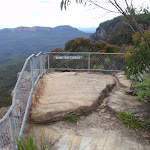
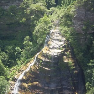
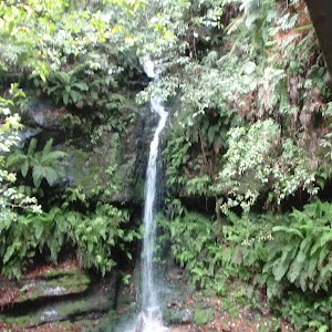
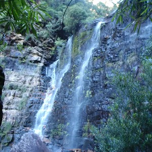
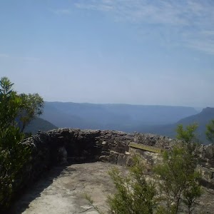
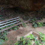
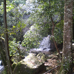
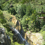
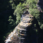
Bridal Veil Lookout

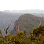
Bridal Veil Lookout provides a great views over Leura Forest and the Jamison Valley. Mount Solitary stands proudly in the distance. In keeping with its name, there are views of Bridal Veil Falls to the east. There is a small bench seat, but no shade.
(0.12km) Int of Prince Henry Cliff Walk and Copelands Lookout Track → Copelands Lookout
170 m
4 mins
2m
-31m
Moderate track
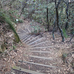
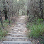
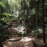
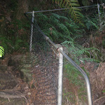
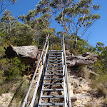
Veer right: From the intersection, this walk follows the ‘Copelands Lookout’ sign down along the bush track, winding down the long, gentle hill to a rock shelf, where it continues down a steep set of wooden steps and along the bush track to the rock platform, fenced off with a short rock wall.
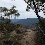
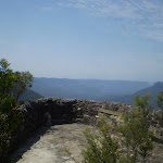
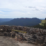
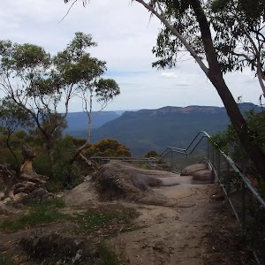
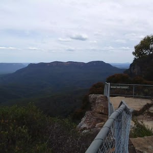
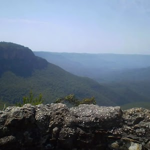
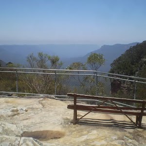
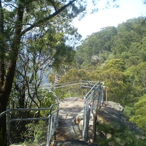
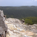
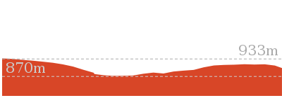
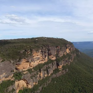
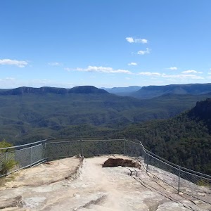
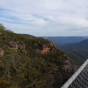
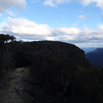
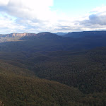
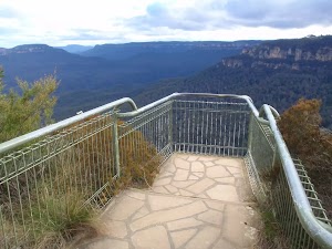
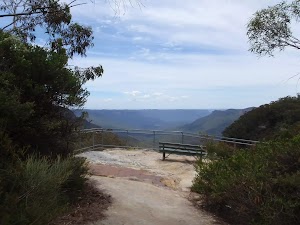
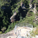
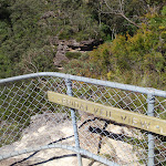
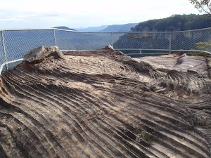
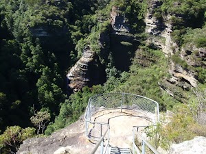
Copelands Lookout
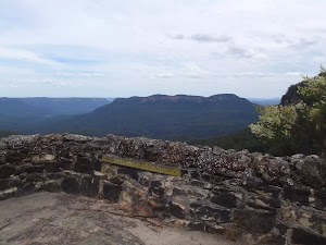
Copelands Lookout is a great viewing point with a short, sandstone wall around much of it. The lookout provides fantastic views over the Jamison Valley past Sublime Point, along Kings Tableland and past Mount Solitary.
Maps for the Solitary Kiosk and Restaurant to Copelands Lookout walk
You can download the PDF for this walk to print a map.
These maps below cover the walk and the wider area around the walk, they are worth carrying for safety reasons.
| Six Foot Track | 1:50 000 Map Series | Six Foot Track | NSW-six-foot-track |
| Katoomba | 1:25 000 Map Series | 89301S KATOOMBA | NSW-89301S |
| Katoomba | 1:100 000 Map Series | 8930 KATOOMBA | 8930 |
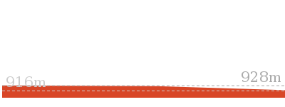
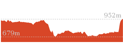
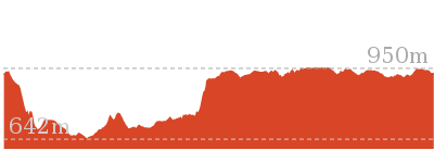
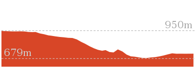
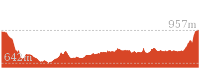
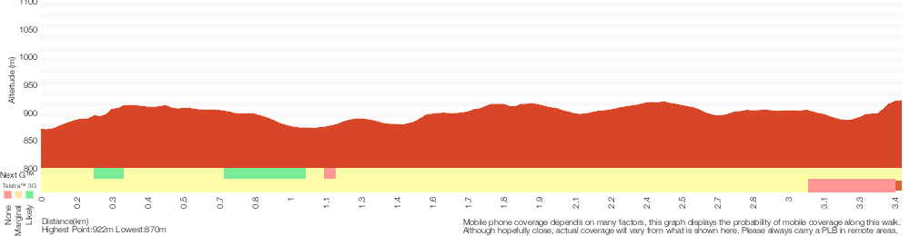
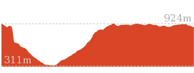
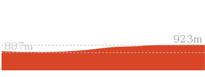
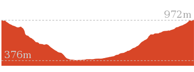
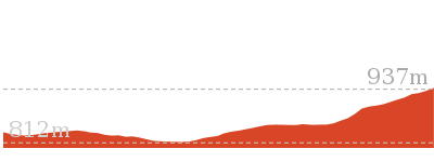
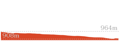
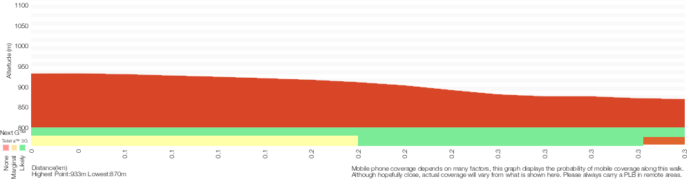
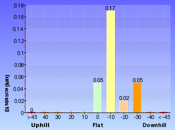
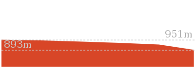
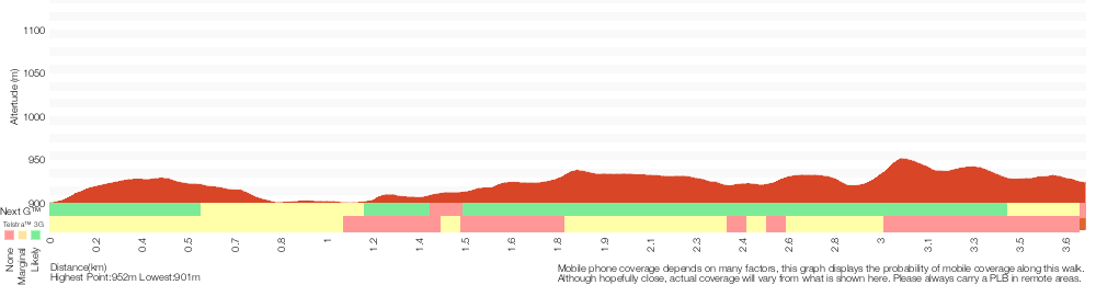
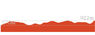
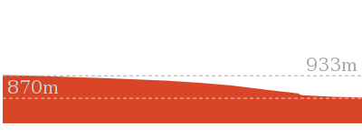
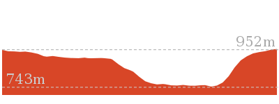
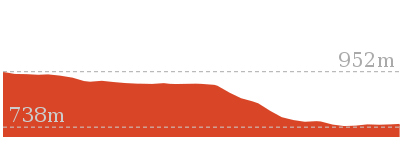
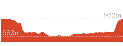
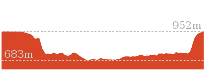
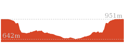
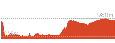
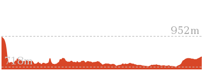
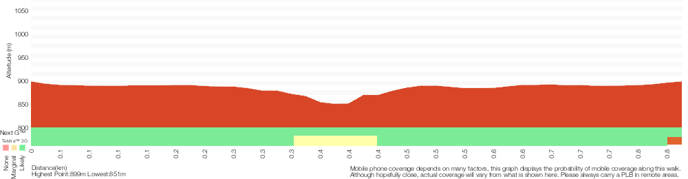
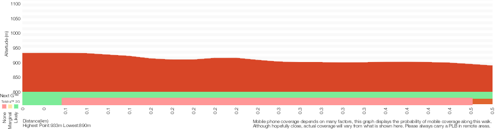
Cross sectional view of the Solitary Kiosk and Restaurant to Copelands Lookout bushwalking track
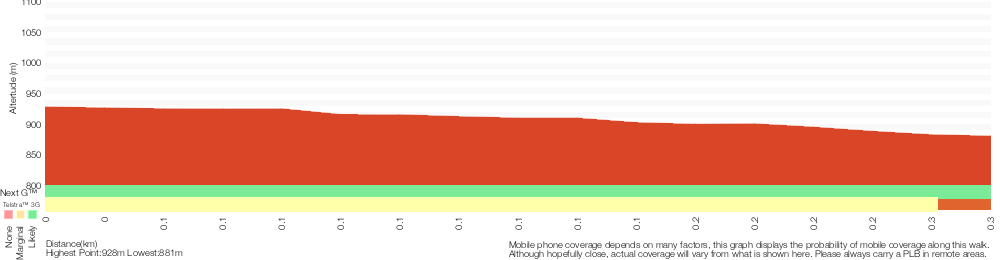
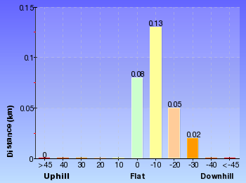
Analysis and summary of the altitude variation on the Solitary Kiosk and Restaurant to Copelands Lookout
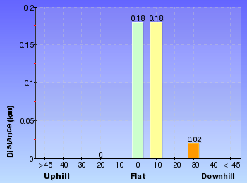
Overview of this walks grade – based on the AS 2156.1 – 2001
Under this standard, a walk is graded based on the most difficult section of the walk.
| Length | 570 m | ||
| Time | 20 mins | ||
| . | |||
| Grade 3/6 Moderate track |
AS 2156.1 | Gradient | Short steep hills (3/6) |
| Quality of track | Formed track, with some branches and other obstacles (3/6) | ||
| Signs | Directional signs along the way (3/6) | ||
| Experience Required | Some bushwalking experience recommended (3/6) | ||
| Weather | Weather generally has little impact on safety (1/6) | ||
| Infrastructure | Limited facilities, not all cliffs are fenced (3/6) |
Some more details of this walks Grading
Here is a bit more details explaining grading looking at sections of the walk
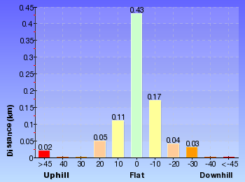
Gradient
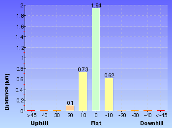
Around 190m of this walk has short steep hills, whilst the remaining 90m has gentle hills with occasional steps.
Quality of track
Around 170m of this walk follows a formed track, with some branches and other obstacles, whilst the remaining 120m follows a clear and well formed track or trail.
Signs
Around 250m of this walk is clearly signposted, whilst the remaining 40m has directional signs at most intersection.
Experience Required
Around 190m of this walk requires some bushwalking experience, whilst the remaining 90m requires no previous bushwalking experience.
weather
This whole walk, 290m is not usually affected by severe weather events (that would unexpectedly impact safety and navigation).
Infrastructure
Around 250m of this walk is close to useful facilities (such as fenced cliffs and seats), whilst the remaining 40m has limited facilities (such as not all cliffs fenced).
Similar walks
A list of walks that share part of the track with the Solitary Kiosk and Restaurant to Copelands Lookout walk.
150 m Return
15 mins
Moderate track
892 m Return
30 mins
Moderate track
1.5 km Return
1 Hr
Moderate track
3.2 km One way
1 hr 45 mins
Moderate track
3.3 km Return
1 hr 30 mins
Moderate track
6.6 km One way
4 hrs
Hard track

6.8 km One way
3 hrs 30 mins
Moderate track
Other Nearby walks
A list of walks that start near the Solitary Kiosk and Restaurant to Copelands Lookout walk.
4.4 km One way
3 hrs 45 mins
Hard track
9.4 km Circuit
5 hrs 30 mins
Hard track
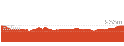
308 m Return
15 mins
Moderate track
582 m Return
30 mins
Moderate track
4.8 km Circuit
3 hrs
Hard track
2.3 km Return
1 hr 30 mins
Hard track
1.7 km Return
1 hr 15 mins
Hard track
8 km One way
5 hrs
Hard track
844 m Circuit
30 mins
Moderate track

844 m Circuit
30 mins
Moderate track
1.8 km One way
1 hr 15 mins
Moderate track
3.6 km Return
2 hrs
Moderate track
Plan your trip to and from the walk here
The Solitary Kiosk and Restaurant to Copelands Lookout walk starts and ends at the Int of Cliff Drive and Prince Henry Cliff Walk (gps: -33.721565, 150.31952)
Your transport options to Int of Cliff Drive and Prince Henry Cliff Walk are by;
![]() Bus. (get details)
Bus. (get details)
![]() Car. There is free parking available.
Car. There is free parking available.
(get details)


Short URL = http://wild.tl/skartcl
Gallery images
There are other downloads I am still working on.
You will probably need to login to access these — still all free.
* KML (google earth file)
* GPX (GPS file)
Special Maps/ brochures
* A3 topo maps
* PDF with Lands Topo map base
* PDF with arial image (and map overlay)
I wanted to get the main site live first, this extra stuff will come in time.
Happy walking
Matt 🙂
Lockley Pylon
And Walk
Lockley Pylon

3 hrs 15 mins
6.8 km Return
338 m
Hard track
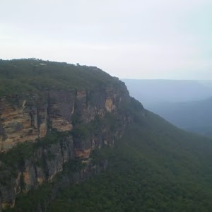
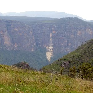
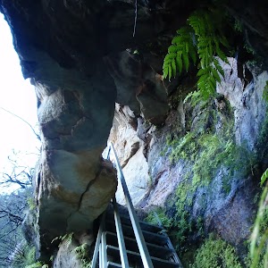
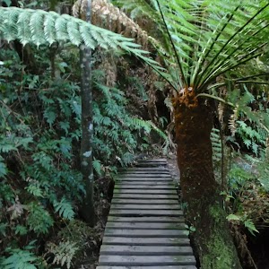
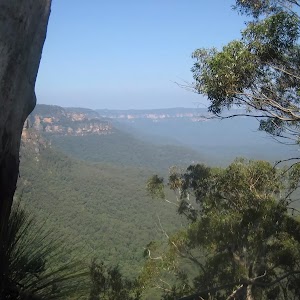
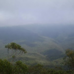
Lockley Pylon Track is an outstanding walk, offering some amazing views and interesting side trips. From Mt Hay Rd, the walk passes the prominent features of the Pinnacles (with an optional side trip exploring these) and climbs to Lockley Pylon, which gives 360-degree views of the Mt Hay area and Grose Valley. Another optional side trip to Fortress Canyon Waterfall is well worth the walk, with its contrasting plateau, cliff and valley features creating some breath-taking scenery.


(0km) Lockley car park → Middle Pinnacle
360 m
10 mins
46m
-3m
Moderate track
From the car park, this walk heads past the sign for ‘Lockley Pylon Track’ and another sign with a map on it. The track leads up a slight hill to tend right, along the edge of a spur. The track slowly climbs to the southern pinnacle (rocky outcrop) and then continues approximately 100m to the intersection below the middle pinnacle.
(0.36km) Middle Pinnacle → Mt Stead Trk
1.5 km
34 mins
72m
-68m
Hard track
Veer right: From the intersection, the walk heads up the hill towards the large rock features. The track continues for approximately 100m to an intersection on the left of a large rock.
Veer right: From the intersection, the walk heads around the large white rock (close to the intersection), soon coming to a small cave.
Veer left: From the intersection, this walk keeps the Pinnacles above to the right of the track, passing the most northern Pinnacle before coming to an intersection.
Veer left: From the intersection, this walk heads up the hill away from the Pinnacles. The track then descends a further 100m into a sandy and flat saddle, until the track rises out up the next hill. The track ascends the hill to gently undulate across the plateau, through the trees. The track then opens out onto a clearing where it continues up the hill for approximately 200m to the intersection on the next rise. The intersection is marked by a rocky outcrop to the left of the track.
(1.9km) Mt Stead Trk → Lockley Pylon
1.6 km
37 mins
82m
-76m
Moderate track
Turn sharp left: From the intersection, this walk heads off the main track to the rock feature, the summit of Mt Stead.
Turn around: From Mt Stead, this walk heads away from the rock feature on the knoll, to the intersection with the main track.
Turn left: From Mt Stead, this walk heads towards the surrounding valleys, leaving the rock feature behind on the left of the track. The track enters the tree line on the other side of the knoll and meanders through the trees for approximately 400m to open out onto a clearing. The track heads down through the clearing to pass to the right of two knolls. The track crosses the saddle and heads up the stairs on Lockley Pylon to a sign marked intersection.
Veer left: From the intersection, this walk follows the sign to ‘Lockley Pylon’ up the wooden stairs to the summit of Lockley Pylon. This is marked by a stone cairn.
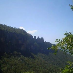
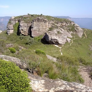
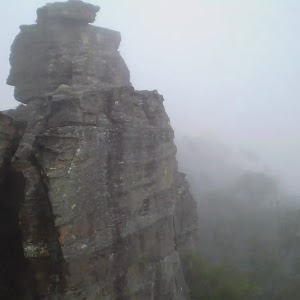
Lockley Pylon
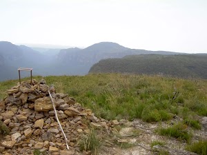
Lockley Pylon, Blue Mountains National Park, gives 360 degree views of the Mt Hay area with excellent scope over Fortress Creek Waterfall and into the Grose Valley.
(3.47km) Lockley Pylon → Fortress Lookout
160 m
5 mins
0m
-46m
Experienced only
Veer left: From Lockley Pylon, this walk heads south-west down the hill, keeping the valley to the right. The track heads down two short cliffs then wanders out to a point overlooking Fortress Creek waterfall. At the end of this side trip, retrace your steps back to the main walk then Turn left.
Maps for the Lockley Pylon walk
You can download the PDF for this walk to print a map.
These maps below cover the walk and the wider area around the walk, they are worth carrying for safety reasons.
| Katoomba | 1:25 000 Map Series | 89301S KATOOMBA | NSW-89301S |
| Katoomba | 1:100 000 Map Series | 8930 KATOOMBA | 8930 |
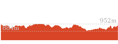
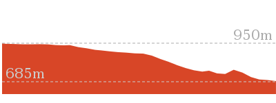
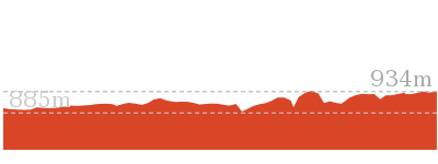
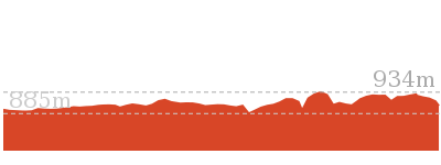
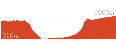
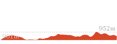
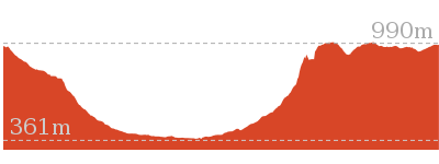
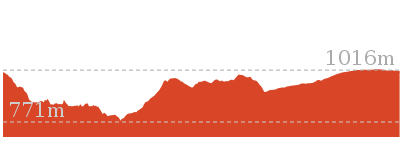
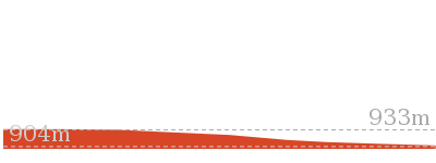
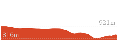
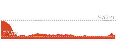
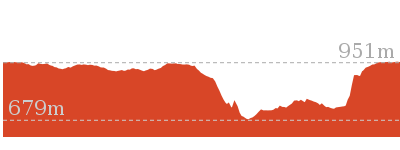
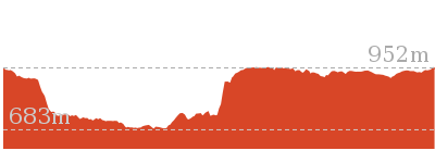
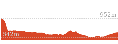
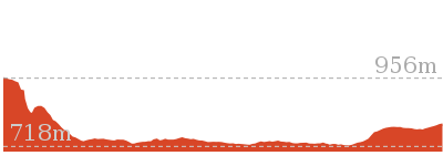
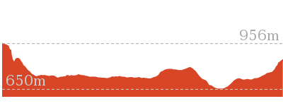
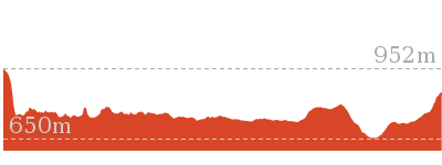
Cross sectional view of the Lockley Pylon bushwalking track
Analysis and summary of the altitude variation on the Lockley Pylon
Overview of this walks grade – based on the AS 2156.1 – 2001
Under this standard, a walk is graded based on the most difficult section of the walk.
| Length | 6.8 km | ||
| Time | 3 hrs 15 mins | ||
| . | |||
| Grade 4/6 Hard track |
AS 2156.1 | Gradient | Short steep hills (3/6) |
| Quality of track | Rough track, where fallen trees and other obstacles are likely (4/6) | ||
| Signs | Directional signs along the way (3/6) | ||
| Experience Required | No experience required (1/6) | ||
| Weather | Weather generally has little impact on safety (1/6) | ||
| Infrastructure | Limited facilities, not all cliffs are fenced (3/6) |
Some more details of this walks Grading
Here is a bit more details explaining grading looking at sections of the walk
Gradient
This whole walk, 3.4km has short steep hills.
Quality of track
Around 2.1km of this walk follows a formed track, with some branches and other obstacles, whilst the remaining 1.3km follows a rough track, where fallen trees and other obstacles are likely.
Signs
This whole walk, 3.4km has directional signs at most intersection.
Experience Required
This whole walk, 3.4km requires no previous bushwalking experience.
weather
This whole walk, 3.4km is not usually affected by severe weather events (that would unexpectedly impact safety and navigation).
Infrastructure
This whole walk, 3.4km has limited facilities (such as not all cliffs fenced).
Similar walks
A list of walks that share part of the track with the Lockley Pylon walk.
8.1 km One way
5 hrs 30 mins
Hard track
16.5 km One way
2 Days
Hard track
Other Nearby walks
A list of walks that start near the Lockley Pylon walk.
1 km Return
30 mins
Moderate track
7.4 km Return
3 hrs
Moderate track
2.9 km Return
1 hr 30 mins
Moderate track

3.1 km Return
2 hrs
Hard track
6.4 km Circuit
4 hrs
Very experienced only
10.7 km Circuit
6 hrs 30 mins
Hard track
5.4 km Circuit
3 hrs 30 mins
Hard track
9.3 km Circuit
4 hrs 30 mins
Hard track
2 km Circuit
1 Hr
Moderate track

3.1 km Return
1 hr 45 mins
Hard track
4.6 km Circuit
2 hrs
Hard track

2.5 km Return
1 Hr
Hard track
Plan your trip to and from the walk here
The Lockley Pylon walk starts and ends at the Lockley car park (gps: -33.651076, 150.37163)
Your main transport option to Lockley car park is by;
![]() Car. There is free parking available.
Car. There is free parking available.
(get details)
Short URL = http://wild.tl/lp
Gallery images
There are other downloads I am still working on.
You will probably need to login to access these — still all free.
* KML (google earth file)
* GPX (GPS file)
Special Maps/ brochures
* A3 topo maps
* PDF with Lands Topo map base
* PDF with arial image (and map overlay)
I wanted to get the main site live first, this extra stuff will come in time.
Happy walking
Matt 🙂
Pool of Siloam
And Walk
Pool of Siloam

30 mins
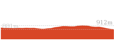
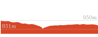
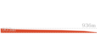
600 m Return
68 m
Moderate track
This lovely walk takes you from the grassy area of Gordon Falls Reserve down through the lush vegetation and cliffs to the Pool of Siloam. The Pool and waterfall is an amazing place and cool place on warmer summer days. This walk is a great way to explore a part of the Blue Mountains after a picnic in the park and a chance to enjoy the cooler climate with the large fern trees.


Gorden Falls Reserve
Gordon Falls Reserve is just off Lone Pine Ave near the intersection with Olympian Pde, Leura. The park has car parking, electric BBQ’s, toilets, garbage disposal, children’s play equipment, picnic tables and bench seats. The park has plenty of open area and some shaded spots. There are a number of artificial cave shelters, with picnic tables inside.
(0km) Gordon Falls Reserve → Int of Lyrebird Dell Trail and Gordon Falls Park Track
250 m
10 mins
2m
-58m
Moderate track
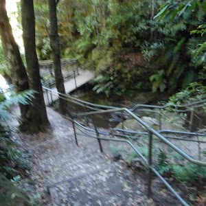
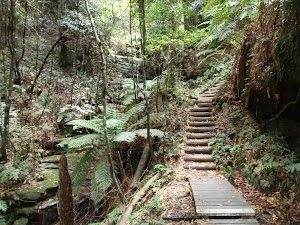
From the lower side of Gordon Falls Reserve, this walk follows the ‘Pool of Siloam’ track sign into the bush, down the gentle hill (passing a track on the left). The walk passes some interesting information signs on local flora and fauna as the track becomes steeper. Continuing down the stairs, the track leads to a rock wall and a handrail. The walk heads along the base of this cliff, under a small waterfall and comes to a three-way intersection (with signposts down to the right and on the other side).
(0.25km) Int of Lyrebird Dell Trail and Gordon Falls Park Track → Pool of Siloam
50 m
1 mins
1m
-7m
Moderate track
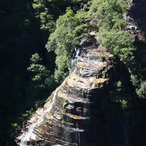
Turn right: From the intersection, this walk follow the ‘Pool of Siloam’ sign down the steps. The track passes under a small overhang then crosses Gordon Creek on a footbridge in front of the lovely falls and the Pool of Siloam.
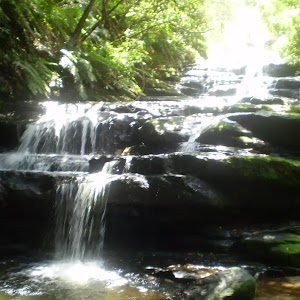
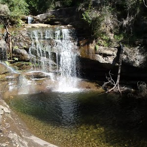
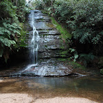
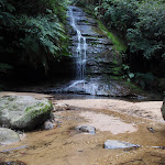
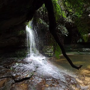
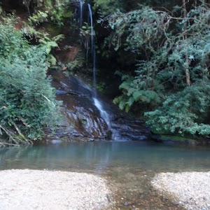
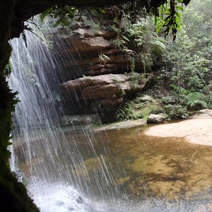
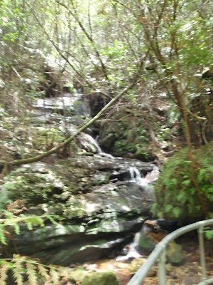
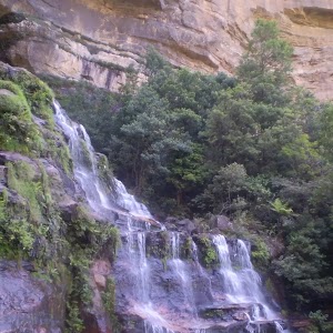
Pool of Siloam
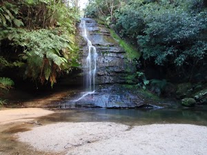
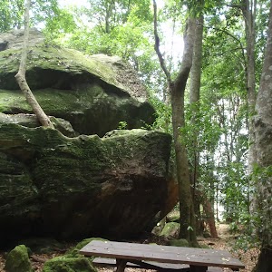
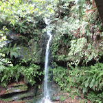
The Pool of Siloam is a lovely waterhole and waterfall on Gordon Creek in the Blue Mountains National Park. This waterfall is surrounded by a moss and fern filled gully with sandstone cliffs around the edges. There is a sandstone overhang next to the waterfall. The shallow sandy pool is a lovely cool place, a great spot to stop for a snack. The track crosses the creek using a bridge in front of the waterfall. The pool derives its name from the ‘Pool of Siloam’ (Birkhat Hashiloah – Hebrew) in the City of David and in the Bible is where Jesus sends a man to heal him of his blindness.
Maps for the Pool of Siloam walk
You can download the PDF for this walk to print a map.
These maps below cover the walk and the wider area around the walk, they are worth carrying for safety reasons.
| Katoomba | 1:25 000 Map Series | 89301S KATOOMBA | NSW-89301S |
| Katoomba | 1:100 000 Map Series | 8930 KATOOMBA | 8930 |
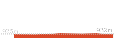
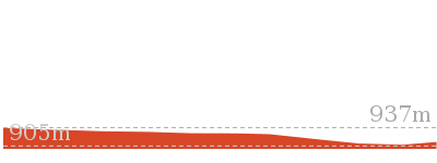
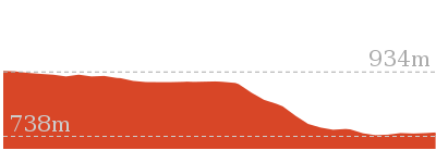
Cross sectional view of the Pool of Siloam bushwalking track
Analysis and summary of the altitude variation on the Pool of Siloam
Overview of this walks grade – based on the AS 2156.1 – 2001
Under this standard, a walk is graded based on the most difficult section of the walk.
| Length | 600 m | ||
| Time | 30 mins | ||
| . | |||
| Grade 3/6 Moderate track |
AS 2156.1 | Gradient | Short steep hills (3/6) |
| Quality of track | Clear and well formed track or trail (2/6) | ||
| Signs | Clearly signposted (1/6) | ||
| Experience Required | No experience required (1/6) | ||
| Weather | Storms may impact on navigation and safety (3/6) | ||
| Infrastructure | Generally useful facilities (such as fenced cliffs and seats) (1/6) |
Some more details of this walks Grading
Here is a bit more details explaining grading looking at sections of the walk
Gradient
This whole walk, 300m has short steep hills.
Quality of track
This whole walk, 300m follows a clear and well formed track or trail.
Signs
This whole walk, 300m is clearly signposted.
Experience Required
This whole walk, 300m requires no previous bushwalking experience.
weather
Around 250m of this walk is affected by storms that may impact your navigation and safety, whilst the remaining 45m is not usually affected by severe weather events (that would unexpectedly impact safety and navigation).
Infrastructure
This whole walk, 300m is close to useful facilities (such as fenced cliffs and seats).
Similar walks
A list of walks that share part of the track with the Pool of Siloam walk.
1.4 km Circuit
1 Hr
Moderate track
1.6 km One way
1 Hr
Moderate track
1.8 km One way
1 hr 15 mins
Moderate track
Other Nearby walks
A list of walks that start near the Pool of Siloam walk.
260 m Return
15 mins
Moderate track
6.6 km One way
4 hrs
Hard track
222 m Return
15 mins
Moderate track
538 m Return
30 mins
Moderate track
752 m Return
30 mins
Moderate track
2 km Circuit
1 Hr
Moderate track
954 m Return
30 mins
Moderate track
432 m Return
15 mins
Easy track
570 m Return
20 mins
Moderate track
150 m Return
15 mins
Moderate track
4.4 km One way
3 hrs 45 mins
Hard track
Plan your trip to and from the walk here
The Pool of Siloam walk starts and ends at the Gordon Falls Reserve (gps: -33.724728, 150.33273)
Your transport options to Gordon Falls Reserve are by;
![]() Bus. (get details)
Bus. (get details)
![]() Car. There is free parking available.
Car. There is free parking available.
(get details)
Short URL = http://wild.tl/pos
Gallery images
There are other downloads I am still working on.
You will probably need to login to access these — still all free.
* KML (google earth file)
* GPX (GPS file)
Special Maps/ brochures
* A3 topo maps
* PDF with Lands Topo map base
* PDF with arial image (and map overlay)
I wanted to get the main site live first, this extra stuff will come in time.
Happy walking
Matt 🙂
Fortress Ridge Trail
And Walk
Fortress Ridge Trail

3 hrs
7.4 km Return
244 m
Moderate track
A fantastic return walk with stunning views, this track leads along the Fortress Ridge, out to the cliffs above the Grose Valley. The views from the lookout and along the trail are superb, with the sheer cliffs and a deep valley to put it all in perspective. The track is popular with canyoners, who use it to access Fortress Canyon.


(0km) Fortress Ridge car park → End of service trail
1.5 km
29 mins
48m
-36m
Moderate track
From the car park (and ‘Fortress Ridge’ sign), this walk heads around the gate and up the hill. The management trail swings right for approximately 50m then turns left. The trail leads to an area of low heath, then tends right (down the hill) for approximately 100m before coming to an intersection.
Continue straight: From the intersection, this walk heads down the hill in a northerly direction. The trail soon rises up a slight hill, passing low heath on the left before continuing up the hill. The walk then flattens out for approximately 200m before slowly rising up another hill for approximately 100m more, coming to an intersection with a smaller track on the left.
Continue straight: From the intersection, this walk heads down the hill in a northerly direction. The trail soon rises up a slight hill, passing low heath on the left before continuing up the hill. The walk then flattens out for approximately 200m before slowly rising up another hill for approximately 100m more, coming to an intersection with a smaller track on the left.
(1.47km) End of service trail → Western Trail Split
220 m
5 mins
11m
-1m
Moderate track
Turn left: From the intersection, the walk heads west up the hill, following the bush track. The track soon comes into view of a knoll, with a rock feature at its head. The track continues to the intersection below this feature.
Veer right: From the intersection, the walk heads up the hill of the knoll, keeping the rock feature to the left of the track. The track continues down the other side, soon coming to an intersection.
Veer right: From the intersection, the walk heads up the hill of the knoll, keeping the rock feature to the left of the track. The track continues down the other side, soon coming to an intersection.
(1.69km) Western Trail Split → Fortress Canyon Entry Trk
270 m
6 mins
15m
-5m
Moderate track
Veer right: From the intersection, this walk heads down the hill, then over a small hill with denser bushland, before coming to a defined ‘Y’ intersection in the track.
(1.96km) Fortress Canyon Entry Trk → Fortress Canyon Exit Trk
1.6 km
33 mins
56m
-61m
Moderate track
Continue straight: From the intersection, the walk does not follow the track marked by the arrow on the rock, but instead heads over a large grey rock surface. The track heads across the ridgeline, undulating over four knolls. The track passes through areas of trees and open heath then turns north, off the last knoll. From this last knoll, the track heads down the spur line, nearing the cliffs on the left. On the spur line, the track comes to an intersection with another track on the right (which heads down into the valley).
(3.55km) Fortress Canyon Exit Trk → Fortress Ridge Lookout
130 m
3 mins
2m
-9m
Moderate track
Veer left: From the intersection, this walk follows the spurline towards the large valley and views of cliffs. The track continues down into a saddle and up to a lookout, near a few bushes on the edge of the cliff.
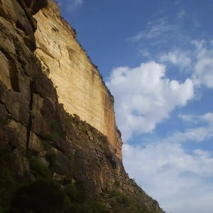
Fortress Ridge
Fortress Ridge lookout has stunning views over the Grose Valley to Govetts Leap, Horseshoe Falls and Blackheath. From the lookout, the vista to the west includes the impressive Lockley’s Pylon, with Mount Hay in the background.
Maps for the Fortress Ridge Trail walk
You can download the PDF for this walk to print a map.
These maps below cover the walk and the wider area around the walk, they are worth carrying for safety reasons.
| Katoomba | 1:25 000 Map Series | 89301S KATOOMBA | NSW-89301S |
| Katoomba | 1:100 000 Map Series | 8930 KATOOMBA | 8930 |
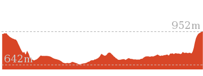
Cross sectional view of the Fortress Ridge Trail bushwalking track
Analysis and summary of the altitude variation on the Fortress Ridge Trail
Overview of this walks grade – based on the AS 2156.1 – 2001
Under this standard, a walk is graded based on the most difficult section of the walk.
| Length | 7.4 km | ||
| Time | 3 hrs | ||
| . | |||
| Grade 3/6 Moderate track |
AS 2156.1 | Gradient | Short steep hills (3/6) |
| Quality of track | Formed track, with some branches and other obstacles (3/6) | ||
| Signs | Directional signs along the way (3/6) | ||
| Experience Required | No experience required (1/6) | ||
| Weather | Weather generally has little impact on safety (1/6) | ||
| Infrastructure | Limited facilities, not all cliffs are fenced (3/6) |
Some more details of this walks Grading
Here is a bit more details explaining grading looking at sections of the walk
Gradient
This whole walk, 3.7km has short steep hills.
Quality of track
This whole walk, 3.7km follows a formed track, with some branches and other obstacles.
Signs
This whole walk, 3.7km has directional signs at most intersection.
Experience Required
This whole walk, 3.7km requires no previous bushwalking experience.
weather
This whole walk, 3.7km is not usually affected by severe weather events (that would unexpectedly impact safety and navigation).
Infrastructure
This whole walk, 3.7km has limited facilities (such as not all cliffs fenced).
Similar walks
A list of walks that share part of the track with the Fortress Ridge Trail walk.
2.9 km Return
1 hr 30 mins
Moderate track
Other Nearby walks
A list of walks that start near the Fortress Ridge Trail walk.
1 km Return
30 mins
Moderate track
6.8 km Return
3 hrs 15 mins
Hard track
16.5 km One way
2 Days
Hard track
3.1 km Return
2 hrs
Hard track
6.4 km Circuit
4 hrs
Very experienced only
10.7 km Circuit
6 hrs 30 mins
Hard track
5.4 km Circuit
3 hrs 30 mins
Hard track
9.3 km Circuit
4 hrs 30 mins
Hard track
2.5 km Return
1 Hr
Hard track
2 km Circuit
1 Hr
Moderate track
3.1 km Return
1 hr 45 mins
Hard track
4.6 km Circuit
2 hrs
Hard track
Plan your trip to and from the walk here
The Fortress Ridge Trail walk starts and ends at the Fortress Ridge car park (gps: -33.658099, 150.3642)
Your main transport option to Fortress Ridge car park is by;
![]() Car. There is free parking available.
Car. There is free parking available.
(get details)
Short URL = http://wild.tl/frxx
Gallery images
There are other downloads I am still working on.
You will probably need to login to access these — still all free.
* KML (google earth file)
* GPX (GPS file)
Special Maps/ brochures
* A3 topo maps
* PDF with Lands Topo map base
* PDF with arial image (and map overlay)
I wanted to get the main site live first, this extra stuff will come in time.
Happy walking
Matt 🙂
Golf Links Lookout from Gladstone Rd
And Walk
Golf Links Lookout from Gladstone Rd

30 mins
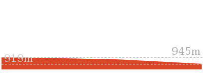
752 m Return
44 m
Moderate track
This pleasant walk offers some scenic views on the way to the breath taking Golf Links Lookout. There are many steps on this worthwhile walk to one of the Blue Mountains’ gems. From the lookout there are grand views across the Jamison Valley, along Narrow Neck and to Mount Solitary. A great spot to stop and enjoy the view before heading back up the stairs.


(0km) End of Gladstone Rd → Golf Links Lookout
380 m
10 mins
0m
-44m
Moderate track
From the end of Gladstone Rd, this walk follows the ‘Pool of Siloam Track’ sign down the steps into the bush, passing a couple of houses (on the right). The steps lead down, passing a track (on the right) along the way. At the bottom of the steps, the walk comes to a three-way intersection (with a flat track on the right).
From the intersection, this walk steps over the small timber drain and continues down the gentle hill, soon passing a chair (on the left) and then heading down a series of steps to come to an intersection and the fenced ‘Golf Links Lookout’.
From the intersection, this walk steps over the small timber drain and continues down the gentle hill, soon passing a chair (on the left) and then heading down a series of steps to come to an intersection and the fenced ‘Golf Links Lookout’.
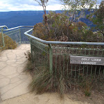
Golf Links Lookout
Golf Links Lookout is a fenced and signposted lookout in the Blue Mountains National Park, near Gladstone Rd Leura. The lookout has great views across the Jamison Valley to the back of the Three Sisters. To the left there is a good view along Narrow Neck and to Mount Solitary. There is no view of the nearby Gordon Falls.
Maps for the Golf Links Lookout from Gladstone Rd walk
You can download the PDF for this walk to print a map.
These maps below cover the walk and the wider area around the walk, they are worth carrying for safety reasons.
| Katoomba | 1:25 000 Map Series | 89301S KATOOMBA | NSW-89301S |
| Katoomba | 1:100 000 Map Series | 8930 KATOOMBA | 8930 |
Cross sectional view of the Golf Links Lookout from Gladstone Rd bushwalking track
Analysis and summary of the altitude variation on the Golf Links Lookout from Gladstone Rd
Overview of this walks grade – based on the AS 2156.1 – 2001
Under this standard, a walk is graded based on the most difficult section of the walk.
| Length | 752 m | ||
| Time | 30 mins | ||
| . | |||
| Grade 3/6 Moderate track |
AS 2156.1 | Gradient | Short steep hills (3/6) |
| Quality of track | Clear and well formed track or trail (2/6) | ||
| Signs | Clearly signposted (1/6) | ||
| Experience Required | No experience required (1/6) | ||
| Weather | Weather generally has little impact on safety (1/6) | ||
| Infrastructure | Generally useful facilities (such as fenced cliffs and seats) (1/6) |
Some more details of this walks Grading
Here is a bit more details explaining grading looking at sections of the walk
Gradient
This whole walk, 380m has short steep hills.
Quality of track
This whole walk, 380m follows a clear and well formed track or trail.
Signs
This whole walk, 380m is clearly signposted.
Experience Required
This whole walk, 380m requires no previous bushwalking experience.
weather
This whole walk, 380m is not usually affected by severe weather events (that would unexpectedly impact safety and navigation).
Infrastructure
This whole walk, 380m is close to useful facilities (such as fenced cliffs and seats).
Similar walks
A list of walks that share part of the track with the Golf Links Lookout from Gladstone Rd walk.
1.6 km One way
1 Hr
Moderate track
Other Nearby walks
A list of walks that start near the Golf Links Lookout from Gladstone Rd walk.
260 m Return
15 mins
Moderate track
6.6 km One way
4 hrs
Hard track
600 m Return
30 mins
Moderate track
1.4 km Circuit
1 Hr
Moderate track
222 m Return
15 mins
Moderate track
538 m Return
30 mins
Moderate track

2.9 km Return
1 hr 30 mins
Moderate track
2 km Circuit
1 Hr
Moderate track
954 m Return
30 mins
Moderate track
432 m Return
15 mins
Easy track
Plan your trip to and from the walk here
The Golf Links Lookout from Gladstone Rd walk starts and ends at the End of Gladstone Rd (gps: -33.72607, 150.3389)
Your transport options to End of Gladstone Rd are by;
![]() Bus. (get details)
Bus. (get details)
![]() Car. There is free parking available.
Car. There is free parking available.
(get details)
Short URL = http://wild.tl/gllxx
Gallery images
There are other downloads I am still working on.
You will probably need to login to access these — still all free.
* KML (google earth file)
* GPX (GPS file)
Special Maps/ brochures
* A3 topo maps
* PDF with Lands Topo map base
* PDF with arial image (and map overlay)
I wanted to get the main site live first, this extra stuff will come in time.
Happy walking
Matt 🙂
Federal Pass Walking Track
And Walk
Federal Pass Walking Track

5 hrs
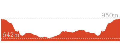
8 km One way
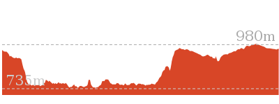
989 m
Hard track
This classic trail follows along the base of the cliffs from Leura to the Golden Stairs, passing many of the more popular sights of the Katoomba region. Travelling through beautiful forest environments, this is one of the longer walks in the area. Leura Forest and Kedumba Falls are both great places to sit and take a break along the journey.


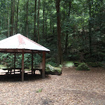


Carrington Park
Carrington Park is a medium-sized park on a traffic island, at the junction of Cliff Road and Merriwa St, Katoomba. The park is partially fenced and has a picnic shelter, picnic tables, garbage bins and children’s play equipment.
(0km) Carrington Park → Int of Federal Pass and Jamieson Lookout Tracks
230 m
5 mins
5m
-22m
Moderate track
From Carrington Park, the walk crosses Cliff Drive and goes down the stairs and past the sign for ‘Blue Mountains National Park’. The walk continues down the stairs until reaching an intersection signposted with the way to ‘Echo Point’ or ‘Leura Cascades’.
Turn left: From the intersection, this walk follows the ‘Leura Cascades 1km’ sign down the wooden steps and along the bush track, winding through the forest until coming to the signposted intersection of the ‘Leura Forest’ Track.
Turn right: From the intersection, this walk follows the ‘Leura Forest’ sign along the bush track, winding down the hill for a short while before dropping down a set of wooden steps, to the signposted intersection with the ‘Jamieson Lookout’ track.
(0.23km) Int of Federal Pass and Jamieson Lookout Tracks → Jamieson Lookout
20 m
1 mins
0m
-6m
Easy track
Turn sharp left: From the intersection, this walk follows the ‘Jamieson Lookout’ sign along the short bush track to the rock shelf at the Jamieson Lookout. At the end of this side trip, retrace your steps back to the main walk then Veer left.
Jamieson Lookout
Jamieson Lookout is a fenced lookout at the east end of the Federal Pass track, and just off Prince Henry Cliff Walk. The lookout has a bench seat and provides great views up the Jamison Valley, along Kings Tableland escarpment and past Mount Solitary. The lookout is perched up on a large rock buttress, giving views unobscured by trees.
(0.23km) Int of Federal Pass and Jamieson Lookout Tracks → Fern Bower
90 m
3 mins
0m
-36m
Hard track
Continue straight: From the intersection, this walk follows the dirt path, heading down the long set of wooden and rocky steps. The walk winds down past a picnic chair under a cliff overhang, and continues down the steps into the valley and through the forest to the Fern Bower information sign.
Fern Bower
Fern Bower is an especially pleasant part of the Blue Mountains National Park, protected from heat and providing a great environment for fern trees, bracken ferns and moss to thrive. Fern Bower is a signposted area along the Federal Pass walking track, just below Jamieson Lookout and next to Linda Creek. This is a nice place to stop, rest and enjoy the bird noises.
(0.32km) Fern Bower → Int of Federal Pass and the Amphitheatre track
320 m
13 mins
10m
-150m
Hard track
Continue straight: From the information sign, the walk follows the track down the steps, passing a ‘Rich History’ information sign before coming down to the signposted intersection with the Amphitheatre track, at the top of a metal staircase.
(0.64km) Int of Federal Pass and the Amphitheatre track → Lila falls crossing
20 m
1 mins
0m
-18m
Moderate track
Turn right: From the intersection, this walk follows the ‘Federal Pass Leura Forest’ sign down the long metal staircase, to cross the bridge over Linda Creek in front of Lila Falls.
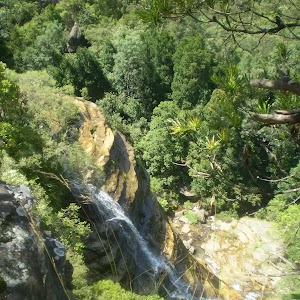
Lila Falls
Lila Falls is a thin waterfall on Linda Creek. The Federal Pass crosses the creek (on a bridge) in front of these falls, just below the intersection with the amphitheatre. The waterfall is not the most spectacular one in this valley, but it is a nice cool spot to catch your breath.
(0.66km) Lila Falls crossing → Marguerite Cascades
180 m
11 mins
37m
-90m
Hard track
Continue straight: From the Lila Falls, this walk follows the track heading down the hill, winding down a wooden walkway keeping the creek to the left. The track hugs the rock wall and passes under a shallow overhang. The walk continues down a staircase, then turns back down into the gully where it come to the taller and slender Linda Falls.
After passing Linda Falls the walk follows the wooden steps down through the gulley, crossing the creek again before heading down to the Marguerite Cascades.
After passing Linda Falls the walk follows the wooden steps down through the gulley, crossing the creek again before heading down to the Marguerite Cascades.
Marguerite Cascades
Marguerite Cascades are a series of small cascades finishing with a taller waterfall of a few metres height, dropping into a shallow sandy pool. The cascades are on Linda Creek and a small bridge crosses the creek at the base of the falls as part of the Federal Pass walking track. The cascades are a nice place to sit and listen to the water running and the local birds in this cool shady area.
(0.84km) Marguerite Cascades → Leura Forest
320 m
11 mins
50m
-14m
Hard track
Continue straight: From the ‘Marguerite Cascades’[1], this walk follows the timber steps downhill, winding steeply for a short while until coming to an intersection with a faint track, marked with a timber ‘Federal Pass’ sign[2], just beside a foot bridge[3].
Veer right: From the intersection, this walk crosses Linda Creek just below a pleasant cascade[4] using the foot bridge with a handrail[5]. This walk then continues along the bush track that winds along the valley floor, to the signposted ‘Leura Forest’. From here, the walk continues along the wide bush track, passing a few picnic tables, and winding through the forest to an open area with a large gazebo and an information sign at the intersection of the Federal Pass and the Dardenelles tracks.
Veer right: From the intersection, this walk crosses Linda Creek just below a pleasant cascade[4] using the foot bridge with a handrail[5]. This walk then continues along the bush track that winds along the valley floor, to the signposted ‘Leura Forest’. From here, the walk continues along the wide bush track, passing a few picnic tables, and winding through the forest to an open area with a large gazebo and an information sign at the intersection of the Federal Pass and the Dardenelles tracks.
Leura Forest

Leura Forest is a great picnic area in the Jamison Valley at the junction of the Federal Pass and Dardenelles Tracks. This place was home to a popular tea house (also known as ‘Lady Carrington Dining Hall’) from the late 1800’s[6]. Today walkers can still enjoy the historic rotunda and the foundations of the original tea house[7]. The picnic area provides a great rest spot under the shade of the lilli pilli and coachwood forest.
(1.16km) Leura Forest (Int of Federal Pass and Dardenelles Tracks) → Int of Federal Pass, Scenic Railway and Dardenelles Tracks
1.3 km
36 mins
117m
-99m
Moderate track
Continue straight: From Leura Forest, the walk follows the ‘Federal Pass’ sign towards ‘Scenic Railway’. Shortly after crossing a small creek using a little bridge, the track begins to steadily go downhill then flatten out. The environment surrounding the bush track at this point is quite dense and, while very pretty, it is difficult to see views of the surrounding area, although there are occasional glimpses of Sublime Point Service Trail on the left. After a while, the track begins to steadily climb to a signposted intersection with ‘Dardenelles Pass’. There are several signposts and a bench seat.
(2.44km) Int of Federal Pass, Scenic Railway and Dardenelles Tracks → Scenic Railway (Bottom Platform)
2.1 km
1 hr 1 mins
210m
-196m
Moderate track
Veer left: From the intersection, the walk follows the ‘Federal Pass’ sign towards ‘Scenic Railway’, keeping the main cliffs on the right. Not long after the intersection, the track passes ‘under the sisters’ rock formation (signposted[8]). From here, the track turns and continues along a relatively stretch and, at several points, passes some notable rock formations and caves embedded in the cliffs. There are occasional good views that are not shrouded by the trees. The walk continues until coming to the base of Katoomba Falls, crossing these using a metal bridge know as ‘Cooks Crossing’. (Just across the bridge, there is a picnic table.)
Continue straight: From the intersection, this walk heads south-west away from Katoomba Falls along the bush track, soon passing the signposted ‘Turpentine Tree’. Shortly after this tree, the track comes to an intersection with another bush track and set of stairs (on the right, signposted as ‘Furber Steps’).
Continue straight: From the bottom of Furber Steps, this walk follows the ‘To base of scenic railway’ sign keeping the handrail on the left, and following the flat bush track. This track passes through a small gate over a metal bridge at the bottom of the Scenic Railway.
(4.5km) Scenic Railway (Bottom Platform) → Landslide
1.3 km
46 mins
175m
-178m
Moderate track
Continue straight: From the bridge over the bottom of the Scenic Railway, this walk follows the signs to ‘scenic walkway’, passing a replica of a mining cart, as well as an old mine. Just past this, the walk comes to a pipeline that runs down the hill collecting fresh water, signposted as drinkable. Continuing past the old mine shafts along the boardwalk, this walk comes to an intersection with a bush track going slightly off to the right. This is signposted as the way to the Landslide.
Continue straight: From the intersection, the walk follows the wide track and signposts towards the ‘landslide’[9] (keeping the cliffs on the right). The walk winds along a bush track with small boulders strewn along it. There are a number of old mine shafts just off the track and some interesting historical items. The track continues under Malaita Point before breaking out of the vegetation to a worthy view of the valley, just before the landslide. As the track comes to the old landslide site, it become rougher with plenty of boulders over the track. There are also excellent views of the cliffs above and the landslide as the vegetation is quite sparse here.
Continue straight: From the intersection, the walk follows the wide track and signposts towards the ‘landslide’[9] (keeping the cliffs on the right). The walk winds along a bush track with small boulders strewn along it. There are a number of old mine shafts just off the track and some interesting historical items. The track continues under Malaita Point before breaking out of the vegetation to a worthy view of the valley, just before the landslide. As the track comes to the old landslide site, it become rougher with plenty of boulders over the track. There are also excellent views of the cliffs above and the landslide as the vegetation is quite sparse here.
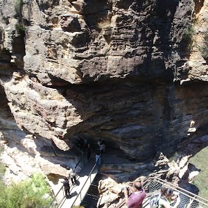
The Landslide
‘The Landslide’ is a large rockfall going into the valley approximately 100m. There is a good vantage point for the landslide from under the cliffs to the east, and a great but more distant view from Narrow Neck lookout. The landslide occurred in 1931 after a few days of rumbling. There has been much debate as to whether this event was helped along by erosion and coal mining in the area at the time.
(5.84km) Landslide → Bottom of Golden Staircase
1.6 km
42 mins
128m
-123m
Moderate track
Continue straight: From the eastern side of the Landslide, the walk heads across the face of the landslide (keeping the cliff on the right). At this point, the track is quite rough, with frequent boulders making it a slight scramble. On the other side of the landslide, the track narrows and becomes a flat bush track that follows the base of the cliffs. The surrounding trees become quite dense again, adding quite an ambiance to the area. The walk heads along the bottom of the Narrow Neck escarpment, until coming to an intersection with a set of stairs off to the right, signposted as the ‘Golden Staircase’.
(7.39km) Bottom of Golden Staircase → Bottings Lookout
430 m
19 mins
177m
-41m
Hard track
Turn right: From the intersection, this walk follows the ‘Golden Stairs car park’ sign[10] uphill past the termite mound[11] then past the ‘Warning – Sections of the Golden Stairs are unfenced and can be slippery when wet’ sign[12]. The walk heads up the broad spur along a narrow track, and before long, starts to climbs the first set of rock and metal stairs. After this climb, the track is relatively flat for a little while before another climb up similar stairs[13]. Then the walk makes its way around a gully[14] to the base of a cliff. From here the track is flat for a while, heading between the cliff and the fence for about 100m[15], (passing a ‘Caution Rockfall Hazard’ sign[16]) before another, smaller climb, up through a gap in the rock[17] to the fenced and signposted ‘Botting’s L.O.’[18].
Botting’s Lookout

Botting’s Lookout[19] offers great views over the Jamison Valley and the cliff line, including the Landslide, Malaita Point and the Golden Stairs. A plaque at the lookout states that the lookout was named after Walter Botting (1887-1985)[20], a pioneer trail-maker of the Katoomba District. More info.
(7.82km) Bottings Lookout → Golden Stairs Track carpark
210 m
8 mins
80m
-9m
Moderate track
Turn left: From Botting’s Lookout[21], the walk heads up the hill where the track then turns left. The walk continues, steeply in a couple of places, up some eroded sections of track[22] and through a couple of switchbacks. Soon the narrow track mostly flattens out. leading to the signposted ‘Golden Stairs’[23] car park[24] on Glenraphael Dr[25].
Maps for the Federal Pass Walking Track walk
You can download the PDF for this walk to print a map.
These maps below cover the walk and the wider area around the walk, they are worth carrying for safety reasons.
| Six Foot Track | 1:50 000 Map Series | Six Foot Track | NSW-six-foot-track |
| Katoomba | 1:25 000 Map Series | 89301S KATOOMBA | NSW-89301S |
| Katoomba | 1:100 000 Map Series | 8930 KATOOMBA | 8930 |
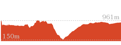
Cross sectional view of the Federal Pass Walking Track bushwalking track
Analysis and summary of the altitude variation on the Federal Pass Walking Track
Overview of this walks grade – based on the AS 2156.1 – 2001
Under this standard, a walk is graded based on the most difficult section of the walk.
| Length | 8 km | ||
| Time | 5 hrs | ||
| . | |||
| Grade 4/6 Hard track |
AS 2156.1 | Gradient | Very steep (4/6) |
| Quality of track | Rough track, where fallen trees and other obstacles are likely (4/6) | ||
| Signs | Directional signs along the way (3/6) | ||
| Experience Required | Some bushwalking experience recommended (3/6) | ||
| Weather | Weather generally has little impact on safety (1/6) | ||
| Infrastructure | Limited facilities, not all cliffs are fenced (3/6) |
Some more details of this walks Grading
Here is a bit more details explaining grading looking at sections of the walk
Gradient
6km of this walk has short steep hills and another 1.2km has gentle hills with occasional steps. Whilst another 620m is very steep and the remaining 190m is flat with no steps.
Quality of track
4km of this walk follows a clear and well formed track or trail and another 3.4km follows a formed track, with some branches and other obstacles. Whilst another 410m follows a rough track, where fallen trees and other obstacles are likely and the remaining 220m follows a smooth and hardened path.
Signs
Around 4km of this walk has directional signs at most intersection, whilst the remaining 4km is clearly signposted.
Experience Required
Around 6km of this walk requires no previous bushwalking experience, whilst the remaining 1.6km requires some bushwalking experience.
weather
This whole walk, 8km is not usually affected by severe weather events (that would unexpectedly impact safety and navigation).
Infrastructure
Around 4.7km of this walk is close to useful facilities (such as fenced cliffs and seats), whilst the remaining 3.3km has limited facilities (such as not all cliffs fenced).
Similar walks
A list of walks that share part of the track with the Federal Pass Walking Track walk.
308 m Return
15 mins
Moderate track
582 m Return
30 mins
Moderate track
869 m Circuit
1 hr 15 mins
Hard track
892 m Return
30 mins
Moderate track
1.7 km Return
2 hrs
Hard track
1.7 km Return
1 hr 15 mins
Hard track
1.7 km Return
3 hrs 45 mins
Hard track
2.3 km Return
1 hr 30 mins
Hard track
2.7 km Return
2 hrs 30 mins
Moderate track
3.1 km One way
3 hrs
Hard track

3.1 km One way
3 hrs
Hard track
3.2 km One way
1 hr 45 mins
Moderate track
3.3 km Return
1 hr 30 mins
Moderate track
3.8 km Circuit
3 hrs
Hard track
4.4 km One way
3 hrs 45 mins
Hard track
4.8 km Circuit
3 hrs
Hard track
4.8 km Circuit
3 hrs
Hard track
4.8 km Circuit
3 hrs
Hard track
5.8 km Circuit
5 hrs 30 mins
Hard track
5.9 km Circuit
3 hrs 30 mins
Hard track
6.6 km One way
4 hrs
Hard track

6.7 km Return
4 hrs 30 mins
Moderate track
6.8 km Circuit
5 hrs
Hard track
6.8 km One way
3 hrs 30 mins
Moderate track
7.9 km Return
5 hrs
Hard track
9.4 km Circuit
5 hrs 30 mins
Hard track
11.7 km Return
8 hrs 45 mins
Experienced only
12.4 km Return
7 hrs 30 mins
Hard track
16.2 km Return
11 hrs
Experienced only

29.2 km One way
2 Days
Experienced only

29.3 km One way
3 Days
Experienced only

33.8 km Circuit
3 Days
Experienced only
Other Nearby walks
A list of walks that start near the Federal Pass Walking Track walk.
570 m Return
20 mins
Moderate track
150 m Return
15 mins
Moderate track
844 m Circuit
30 mins
Moderate track
844 m Circuit
30 mins
Moderate track
1.8 km One way
1 hr 15 mins
Moderate track
1.5 km Return
1 Hr
Moderate track
3.6 km Return
2 hrs
Moderate track
2 km Circuit
1 Hr
Moderate track
954 m Return
30 mins
Moderate track
432 m Return
15 mins
Easy track
538 m Return
30 mins
Moderate track
1.6 km One way
1 Hr
Moderate track
Plan your trip to and from the walk here
The Federal Pass Walking Track walk starts at the Carrington Park (gps: -33.720233, 150.31744)
Your transport options to Carrington Park are by;
![]() Bus. (get details)
Bus. (get details)
![]() Car. There is free parking available.
Car. There is free parking available.
(get details)
The Federal Pass Walking Track ends at the Golden Stairs Track carpark (gps: -33.734348, 150.28237)
Your main transport option to Golden Stairs Track carpark is by;
![]() Car. There is free parking available.
Car. There is free parking available.
(get details)
Short URL = http://wild.tl/fpwt
Gallery images
There are other downloads I am still working on.
You will probably need to login to access these — still all free.
* KML (google earth file)
* GPX (GPS file)
Special Maps/ brochures
* A3 topo maps
* PDF with Lands Topo map base
* PDF with arial image (and map overlay)
I wanted to get the main site live first, this extra stuff will come in time.
Happy walking
Matt 🙂
Leura Cascades Circuit
And Walk
Leura Cascades Circuit

30 mins
844 m Circuit
62 m
Moderate track


Leura Cascades Picnic Area
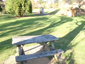
Leura Cascades Picnic area is a open picnic area beside Cliff Drive, with Leura Cascades Creek running through the middle. There are a number of small cascades in the park, along with toilets and picnic tables. There are a few information signs and maps of the area. The park is well remembered for the artificial caves and arches that have been built to provide shelter and a sense of place. A small road runs through the park, providing access and parking, and garbage facilities are provided. There is also plenty of shade from some large pine trees.
(0km) Leura Cascades Picnic Area → Int of Prince Henry Cliff Walk and Leura Cascades Picnic Area Track
120 m
3 mins
0m
-9m
Easy track
From cave-like shelters in Leura Cascades Picnic Area, this walk heads along the footpath, passing under the arch. Passing the toilet block, the path comes to the information board, from where the walk follows the ‘Leura Cascades Track’ sign down the steps. The path soon leads to a small stone wall with a view of some cascades and Chelmsford Bridge.
From the view of Chelmsford Bridge, this walk follows track downhill, keeping the handrail and creek to the left, soon coming to an intersection with ‘Prince Henry Cliff Walk’ just before a footbridge.
From the view of Chelmsford Bridge, this walk follows track downhill, keeping the handrail and creek to the left, soon coming to an intersection with ‘Prince Henry Cliff Walk’ just before a footbridge.
(0.12km) Int of Prince Henry Cliff Walk and Leura Park Track → Int of Prince Henry Cliff Walk and Leura Cascades Round Walk (NE)
30 m
1m
0m
Easy track
Continue straight: From the intersection, this walk follows the ‘Leura Cascades’ sign across the footbridge to a ‘Y’ intersection.
(0.14km) Int of Prince Henry Cliff Walk and Leura Cascades Round Walk (NE) → Leura Cascades
170 m
4 mins
1m
-13m
Moderate track
Continue straight: From the intersection, this walk follows the ‘Leura Cascades’ sign down the steps, keeping the handrail and creek to the right. After a short while, the walk heads along a timber platform and down some stairs to a rock platform, with great views of some cascades.
From these cascades, the walk heads down more stairs, coming to an intersection just before two bridges, with great views of Leura Cascades.
From these cascades, the walk heads down more stairs, coming to an intersection just before two bridges, with great views of Leura Cascades.
Leura Cascades

Leura Cascades is a lovely set of waterfalls with some bridges just below, allowing walkers to get up close to the creek. The area has a nice feel about it and is quite cool in summer. Much of the track near the cascades has handrails and the bridges are fenced. Allow some time to enjoy life among the cascades and fern trees in this valley. One bridge leads to a sandstone cave next to the pool and falls, a great place to enjoy the small section of canyon.
(0.31km) Leura Cascades → Round Walk Lookout
90 m
4 mins
1m
-30m
Moderate track
Continue straight: From the bottom of Leura Cascades, this walk crosses the bridge (furthest from the falls), heads down the steps and comes to a fenced (unsignposted) lookout at the top of Bridal Veil Falls.
From the lookout, the walk heads up the steep steps. The steps wind up the hill passing a cave with an old bench seat, then up the metal stairs to the fenced (unsignposted) round walk lookout with views down on Bridal Veil Falls.
From the lookout, the walk heads up the steep steps. The steps wind up the hill passing a cave with an old bench seat, then up the metal stairs to the fenced (unsignposted) round walk lookout with views down on Bridal Veil Falls.
(0.4km) Round Walk Lookout → Int of Leura Cascades Round Walk and Fern Bower Track
20 m
1 mins
18m
0m
Moderate track
Continue straight: From the lookout, the walk heads up the metal staircases then along the fenced cliff ledge, with more great valley views. Soon the track heads down a few steps to come to a a four-way intersection, with a sign pointing back to ‘Leura Cascades’ (and the short left-hand track leading to a fenced (unnamed) lookout.
(0.42km) Int of Leura Cascades Round Walk and Fern Bower Track → Int of Prince Henry Cliff Walk and the Leura Int of Prince Henry Cliff and Cascades Round Walk (SW)
70 m
2 mins
20m
0m
Moderate track
Continue straight: From the intersection, this walk follows the ‘Round Walk – Echo Point’ sign along the track up the hill (with rock wall initially on the right). The track winds up the hill using the steps and, after passing a large gum, the track become less steep. Soon the track leads to an intersection with the signposted ‘Prince Henry Cliff Walk’.
(0.49km) Int of Prince Henry Cliff Walk and the Leura Int of Prince Henry Cliff and Cascades Round Walk (SW) → Int of Prince Henry Cliff Walk and Majestic Lookout Track
50 m
1 mins
1m
-7m
Moderate track
Turn right: From the intersection, this walk follows the sign along the ‘Prince Henry Cliff Walk’ towards ‘Leura Cascades’, taking the higher track. The track heads along the side of the hill to come to a three-way intersection, just after passing a rock wall on the left.
(0.54km) Int of Prince Henry Cliff Walk and Majestic Lookout Track → Majestic Lookout
30 m
1 mins
0m
-13m
Moderate track
Veer right: From the intersection, this walk follows the track away from the rocks down the narrow spur. The track soon comes to a rusty fence that leads to the signposted ‘Majestic Lookout’ and then down some steps to the lower platform. At the end of this side trip, retrace your steps back to the main walk then Veer right.
Majestic Lookout

Majestic Lookout is a fenced lookout on a side track from the Prince Henry Cliff Walk, just above Leura Cascades. The lookout provides great (perhaps even majestic) views out through the top of the valley, with Mount Solitary nicely framed by the cliff line. The closest access to the lookout is from Leura Cascades Picnic Area, and is visited as part of the Leura Cascades Circuit.
(0.54km) Int of Prince Henry Cliff Walk and Majestic Lookout Track → Int of Prince Henry Cliff Walk and Leura Park Track
190 m
4 mins
11m
-6m
Moderate track
Turn left: From the intersection, this walk steps up over a few rocks to keep the main rock outcrop on the left (and the valley and waterfall on the right). The track soon passes a small overhang with a bench seat, and gently winds along the side of the hill. After heading down the stairs, the track come to a ‘T’ intersection, with a handrail and a sign pointing back up to ‘Echo Point’.
(0.73km) Int of Prince Henry Cliff Walk and Leura Cascades Picnic Area Track → Leura Cascades Picnic Area
120 m
3 mins
9m
0m
Easy track
Turn left: From the intersection, this walk follows the ‘Picnic Area’ sign up the gentle hill, keeping the handrail and creek on the right. The track soon comes to a stone wall with a view of some cascades and Chelmsford Bridge.
From the view of Chelmsford Bridge, this walk heads up the steps, following the path past an information board, toilet and under the arch to come to Leura Cascades Picnic Area.
From the view of Chelmsford Bridge, this walk heads up the steps, following the path past an information board, toilet and under the arch to come to Leura Cascades Picnic Area.
Maps for the Leura Cascades Circuit walk
You can download the PDF for this walk to print a map.
These maps below cover the walk and the wider area around the walk, they are worth carrying for safety reasons.
| Six Foot Track | 1:50 000 Map Series | Six Foot Track | NSW-six-foot-track |
| Katoomba | 1:25 000 Map Series | 89301S KATOOMBA | NSW-89301S |
| Katoomba | 1:100 000 Map Series | 8930 KATOOMBA | 8930 |
Cross sectional view of the Leura Cascades Circuit bushwalking track
Analysis and summary of the altitude variation on the Leura Cascades Circuit
Overview of this walks grade – based on the AS 2156.1 – 2001
Under this standard, a walk is graded based on the most difficult section of the walk.
| Length | 844 m | ||
| Time | 30 mins | ||
| . | |||
| Grade 3/6 Moderate track |
AS 2156.1 | Gradient | Short steep hills (3/6) |
| Quality of track | Formed track, with some branches and other obstacles (3/6) | ||
| Signs | Directional signs along the way (3/6) | ||
| Experience Required | Some bushwalking experience recommended (3/6) | ||
| Weather | Storms may impact on navigation and safety (3/6) | ||
| Infrastructure | Limited facilities, not all cliffs are fenced (3/6) |
Some more details of this walks Grading
Here is a bit more details explaining grading looking at sections of the walk
Gradient
540m of this walk has short steep hills and another 260m has gentle hills with occasional steps. The remaining (45m) is flat with no steps.
Quality of track
Around 660m of this walk follows a clear and well formed track or trail, whilst the remaining 180m follows a formed track, with some branches and other obstacles.
Signs
Around 820m of this walk is clearly signposted, whilst the remaining 20m has directional signs at most intersection.
Experience Required
Around 660m of this walk requires no previous bushwalking experience, whilst the remaining 180m requires some bushwalking experience.
weather
Around 670m of this walk is not usually affected by severe weather events (that would unexpectedly impact safety and navigation), whilst the remaining 170m is affected by storms that may impact your navigation and safety.
Infrastructure
Around 520m of this walk is close to useful facilities (such as fenced cliffs and seats), whilst the remaining 330m has limited facilities (such as not all cliffs fenced).
Similar walks
A list of walks that share part of the track with the Leura Cascades Circuit walk.
844 m Circuit
30 mins
Moderate track
1.5 km Return
1 Hr
Moderate track
1.8 km One way
1 hr 15 mins
Moderate track
3.2 km One way
1 hr 45 mins
Moderate track
3.3 km Return
1 hr 30 mins
Moderate track
3.6 km Return
2 hrs
Moderate track
6.6 km One way
4 hrs
Hard track
6.8 km One way
3 hrs 30 mins
Moderate track
Other Nearby walks
A list of walks that start near the Leura Cascades Circuit walk.
582 m Return
30 mins
Moderate track
892 m Return
30 mins
Moderate track
4.8 km Circuit
3 hrs
Hard track
2.3 km Return
1 hr 30 mins
Hard track
1.7 km Return
1 hr 15 mins
Hard track
8 km One way
5 hrs
Hard track
570 m Return
20 mins
Moderate track
150 m Return
15 mins
Moderate track
4.4 km One way
3 hrs 45 mins
Hard track
9.4 km Circuit
5 hrs 30 mins
Hard track
308 m Return
15 mins
Moderate track
2 km Circuit
1 Hr
Moderate track
Plan your trip to and from the walk here
The Leura Cascades Circuit walk starts and ends at the Leura Cascades Picnic Area (gps: -33.719623, 150.3224)
Your transport options to Leura Cascades Picnic Area are by;
![]() Bus. (get details)
Bus. (get details)
![]() Car. There is free parking available.
Car. There is free parking available.
(get details)
Short URL = http://wild.tl/lcc
Gallery images
There are other downloads I am still working on.
You will probably need to login to access these — still all free.
* KML (google earth file)
* GPX (GPS file)
Special Maps/ brochures
* A3 topo maps
* PDF with Lands Topo map base
* PDF with arial image (and map overlay)
I wanted to get the main site live first, this extra stuff will come in time.
Happy walking
Matt 🙂
Bridal Veil View Lookout Leura
And Walk
Bridal Veil View Lookout Leura

30 mins
954 m Return
64 m
Moderate track
This short walk from Cliff Drive, Leura, heads out to pretty Bridal Veil View Lookout. At the base of a staircase, the lookout provides great views of Bridal Veil Falls. There is also an optional side trip to Tarpeian Rock, which is well worth the extra time, providing great views up the Jamison valley.


(0km) Cliff Drive → Int of Prince Henry Cliff Walk Tarpeian Rock Track
170 m
5 mins
0m
-23m
Easy track
From the Cliff Drive, one house west from Olympian Parade, this walk follows the ‘Tarpeian Rock’ signpost along the bush track, following the sandstone wall. The track soon passes the ‘Blue Mountains National Park’ sign as it winds through the bush for a short while, then winds down a hill that gradually gets a little steeper as it approaches the intersection of the Prince Henry Cliff Walk at the ‘Leura Cascades’ sign.
(0.17km) Int of Prince Henry Cliff Walk Tarpeian Rock Track → Tarpeian Rock
50 m
1 mins
1m
-7m
Easy track
Continue straight: From the intersection, the walk follows the ‘Tarpeian Rock’ sign along the bush track, heading through the dense scrub for a short distance before coming to the Tarpeian Rock lookout. At the end of this side trip, retrace your steps back to the main walk then Turn left.
Tarpeian Rock
Tarpeian Rock is a great lookout, suspended high on a sandstone buttress, with circular patterns under foot. The view from the lookout extends from Kings Tableland on the left, to the ‘back’ of the Three Sisters and into Jamison Valley on the right. There are also great views across to Mount Solitary, Narrow Neck Plateau and the Ruined Castle. The name is derived from the Roman ‘Tarpeian Rock’, a steep cliff rocky point overlooking the Roman forum that was used as a place to execute people. Thankfully, this Tarpeian Rock has a much more peaceful feel about it. More info.
(0.17km) Int of Prince Henry Cliff Walk and Tarpeian Rock Track → Bridal Veil View lookout
310 m
8 mins
11m
-30m
Moderate track
Turn right: From the intersection, this walk follows the ‘Leura Cascades’ signpost down the rocky hill and through the dense forest until coming to the signposted intersection with the Bridal Veil lookout track.
Veer left: From the intersection, the walk follows the ‘Bridal View Lookout’ sign along the track, heading out towards the cliffs for a short while before winding down a set of metal stairs to the signposted ‘Bridal Veil View’ lookout.
Veer left: From the intersection, the walk follows the ‘Bridal View Lookout’ sign along the track, heading out towards the cliffs for a short while before winding down a set of metal stairs to the signposted ‘Bridal Veil View’ lookout.
Bridal Veil View Lookout
The Bridal Veil View is a small, fenced lookout at the base of a flight of stairs in the south-west corner of Leura. The lookout has a natural sandstone floor and provides superb, unobstructed view of the Bridal Veil Falls. The falls are about 150m away, and looking down from the top, the Bridal Veil likeness is apparent. The falls run most of the time, but are most spectacular after rain.
Maps for the Bridal Veil View Lookout Leura walk
You can download the PDF for this walk to print a map.
These maps below cover the walk and the wider area around the walk, they are worth carrying for safety reasons.
| Six Foot Track | 1:50 000 Map Series | Six Foot Track | NSW-six-foot-track |
| Katoomba | 1:25 000 Map Series | 89301S KATOOMBA | NSW-89301S |
| Katoomba | 1:100 000 Map Series | 8930 KATOOMBA | 8930 |
Cross sectional view of the Bridal Veil View Lookout Leura bushwalking track
Analysis and summary of the altitude variation on the Bridal Veil View Lookout Leura
Overview of this walks grade – based on the AS 2156.1 – 2001
Under this standard, a walk is graded based on the most difficult section of the walk.
| Length | 954 m | ||
| Time | 30 mins | ||
| . | |||
| Grade 3/6 Moderate track |
AS 2156.1 | Gradient | Short steep hills (3/6) |
| Quality of track | Clear and well formed track or trail (2/6) | ||
| Signs | Clearly signposted (1/6) | ||
| Experience Required | No experience required (1/6) | ||
| Weather | Weather generally has little impact on safety (1/6) | ||
| Infrastructure | Limited facilities, not all cliffs are fenced (3/6) |
Some more details of this walks Grading
Here is a bit more details explaining grading looking at sections of the walk
Gradient
Around 280m of this walk has gentle hills with occasional steps, whilst the remaining 200m has short steep hills.
Quality of track
This whole walk, 480m follows a clear and well formed track or trail.
Signs
This whole walk, 480m is clearly signposted.
Experience Required
This whole walk, 480m requires no previous bushwalking experience.
weather
This whole walk, 480m is not usually affected by severe weather events (that would unexpectedly impact safety and navigation).
Infrastructure
Around 360m of this walk is close to useful facilities (such as fenced cliffs and seats), whilst the remaining 110m has limited facilities (such as not all cliffs fenced).
Similar walks
A list of walks that share part of the track with the Bridal Veil View Lookout Leura walk.
432 m Return
15 mins
Easy track
1.8 km One way
1 hr 15 mins
Moderate track
2 km Circuit
1 Hr
Moderate track
3.3 km Return
1 hr 30 mins
Moderate track
3.6 km Return
2 hrs
Moderate track
6.6 km One way
4 hrs
Hard track
6.8 km One way
3 hrs 30 mins
Moderate track
Other Nearby walks
A list of walks that start near the Bridal Veil View Lookout Leura walk.
570 m Return
20 mins
Moderate track
150 m Return
15 mins
Moderate track
4.4 km One way
3 hrs 45 mins
Hard track
9.4 km Circuit
5 hrs 30 mins
Hard track
308 m Return
15 mins
Moderate track
844 m Circuit
30 mins
Moderate track
844 m Circuit
30 mins
Moderate track
1.5 km Return
1 Hr
Moderate track
538 m Return
30 mins
Moderate track
1.6 km One way
1 Hr
Moderate track
222 m Return
15 mins
Moderate track
Plan your trip to and from the walk here
The Bridal Veil View Lookout Leura walk starts and ends at the Cliff Drive (gps: -33.72233, 150.32586)
Your transport options to Cliff Drive are by;
![]() Bus. (get details)
Bus. (get details)
![]() Car. There is free parking available.
Car. There is free parking available.
(get details)
Short URL = http://wild.tl/bvvll
Gallery images
There are other downloads I am still working on.
You will probably need to login to access these — still all free.
* KML (google earth file)
* GPX (GPS file)
Special Maps/ brochures
* A3 topo maps
* PDF with Lands Topo map base
* PDF with arial image (and map overlay)
I wanted to get the main site live first, this extra stuff will come in time.
Happy walking
Matt 🙂
Flat Top
And Walk
Flat Top

30 mins
1 km Return
46 m
Moderate track
The walk to the summit of Flat Top is a very short climb. A treat awaits at the summit, with a near-360 degree view of the surrounding valleys, including the Grose Valley. There are also great views to other features including Mt Hay and Lockley Pylon. The walk and mountain itself may be short, but the views are spectacular and well worth exploring.
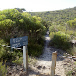
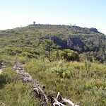
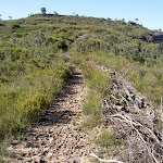


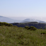

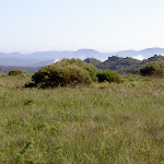
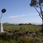
(0km) Flat Top car park → Flat Top Summit
510 m
12 mins
38m
-8m
Moderate track
From the car park, this walk crosses the road to the opening in the thick wire fence, then follows the ‘Flat Top’ sign up the sandy track. After approximately 50m, the track passes an alternate exit to the management trail (on the left). The track continues up the hill, tending right up a steeper, rockier gradient. The track continues up to three metal ruts on the left of a rocky outcrop. The track heads up to the flat of the plateau, leading along an overgrown management trail to an obvious trig station.
Maps for the Flat Top walk
You can download the PDF for this walk to print a map.
These maps below cover the walk and the wider area around the walk, they are worth carrying for safety reasons.
| Katoomba | 1:25 000 Map Series | 89301S KATOOMBA | NSW-89301S |
| Katoomba | 1:100 000 Map Series | 8930 KATOOMBA | 8930 |
Cross sectional view of the Flat Top bushwalking track

Analysis and summary of the altitude variation on the Flat Top

Overview of this walks grade – based on the AS 2156.1 – 2001
Under this standard, a walk is graded based on the most difficult section of the walk.
| Length | 1 km | ||
| Time | 30 mins | ||
| . | |||
| Grade 3/6 Moderate track |
AS 2156.1 | Gradient | Short steep hills (3/6) |
| Quality of track | Formed track, with some branches and other obstacles (3/6) | ||
| Signs | Directional signs along the way (3/6) | ||
| Experience Required | No experience required (1/6) | ||
| Weather | Weather generally has little impact on safety (1/6) | ||
| Infrastructure | Limited facilities, not all cliffs are fenced (3/6) |
Some more details of this walks Grading
Here is a bit more details explaining grading looking at sections of the walk
Gradient
This whole walk, 510m has short steep hills.
Quality of track
This whole walk, 510m follows a formed track, with some branches and other obstacles.
Signs
This whole walk, 510m has directional signs at most intersection.
Experience Required
This whole walk, 510m requires no previous bushwalking experience.
weather
This whole walk, 510m is not usually affected by severe weather events (that would unexpectedly impact safety and navigation).
Infrastructure
This whole walk, 510m has limited facilities (such as not all cliffs fenced).
Similar walks
A list of walks that share part of the track with the Flat Top walk.
Other Nearby walks
A list of walks that start near the Flat Top walk.
6.8 km Return
3 hrs 15 mins
Hard track
16.5 km One way
2 Days
Hard track
7.4 km Return
3 hrs
Moderate track
2.9 km Return
1 hr 30 mins
Moderate track
3.1 km Return
2 hrs
Hard track
6.4 km Circuit
4 hrs
Very experienced only
10.7 km Circuit
6 hrs 30 mins
Hard track
5.4 km Circuit
3 hrs 30 mins
Hard track
9.3 km Circuit
4 hrs 30 mins
Hard track
2 km Circuit
1 Hr
Moderate track
3.1 km Return
1 hr 45 mins
Hard track
4.6 km Circuit
2 hrs
Hard track
Plan your trip to and from the walk here
The Flat Top walk starts and ends at the Flat Top car park (gps: -33.651867, 150.36963)
Your main transport option to Flat Top car park is by;
![]() Car. There is free parking available.
Car. There is free parking available.
(get details)
Short URL = http://wild.tl/ft
Gallery images
There are other downloads I am still working on.
You will probably need to login to access these — still all free.
* KML (google earth file)
* GPX (GPS file)
Special Maps/ brochures
* A3 topo maps
* PDF with Lands Topo map base
* PDF with arial image (and map overlay)
I wanted to get the main site live first, this extra stuff will come in time.
Happy walking
Matt 🙂
Lyrebird Dell and Pool of Siloam Circuit

1 Hr
1.4 km Circuit
97 m
Moderate track
This is a magnificent round trip which passes some amazing scenery with Lyrebird Dell featuring. The walk takes in both sides of the valley, with a worthwhile sidetrip option which explores the Pool of Siloam. The walk is a cool shady path with a number of places to stop and take in your surroundings.

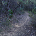


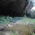
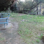
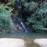


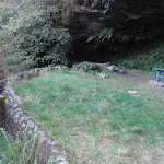

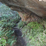
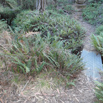
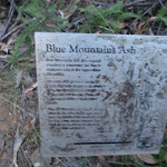
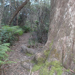
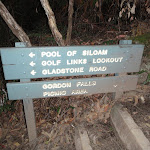
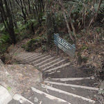

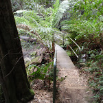
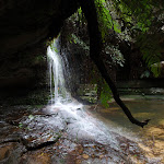


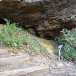
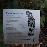
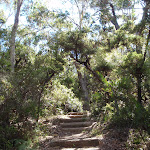
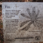

Gorden Falls Reserve
Gordon Falls Reserve is just off Lone Pine Ave near the intersection with Olympian Pde, Leura. The park has car parking, electric BBQ’s, toilets, garbage disposal, children’s play equipment, picnic tables and bench seats. The park has plenty of open area and some shaded spots. There are a number of artificial cave shelters, with picnic tables inside.
(0km) Gordon Falls Reserve → Int of Gordon Rd and Lone Pine Ave
230 m
4 mins
5m
-6m
Moderate track
From the lower end of Gordon Falls Reserve (at the ‘Pool of Siloam’ track sign), this walk heads into the bush (not down the steps), initially with the ‘Pool of Siloam’ sign on the right. The track heads through the thick bush, turning left at the ‘T’ intersection and following this track until it comes out on the road (at the intersection of Gordon Rd and Lone Pine Ave).
(0.23km) Int of Gordon Rd and Lone Pine Ave → Int of Lyrebird Dell track and Leura Dirt Track
260 m
5 mins
2m
-9m
Easy track
Veer right: From the intersection of Gordon Rd and Lone Pine Ave, this walk heads around the metal gate (keeping the picnic area to the right) and follows the wide ‘Leura Dirt Track’. This management trail soon bends right. Just after passing some more picnic tables (on the right), the walk turns left at the ‘T’ intersection, following this trail to soon come to the signposted ‘Lyre Bird Dell Track’ (on the right)
(0.49km) Int of Lyrebird Dell track and Leura Dirt Track → Lyrebird Dell
90 m
4 mins
5m
-19m
Moderate track
Turn right: From the intersection, this walk follows the ‘Lyre Bird Dell Track’ sign down the hill using the timber steps. Soon the track heads down some concrete steps (with a handrail) and passes a ‘1918 11-11-11’ inscription on the path (presumably in commemoration of Armistice treaty with Germany). The walk continues down the stairs to the valley. After admiring the waterfall (on the left), this walk crosses the metal bridge and comes to a sign (pointing right, to the ‘Pool of Siloam’) and straight ahead is the Lyrebird Dell (cave).
Lyrebird Dell

Lyrebird Dell is home to a sandstone cave beside the head waters of Gordon Creek near Lone Pine Ave, Leura. The cave provides shelter for a lovely picnic area (with a couple of tables). There is also a waterfall next to the cave. The cave at Lyrebird Dell, was used as an Aboriginal shelter from (at least) 12 000 years ago, this has been dated from artifacts found in the floor of the cave
. Dell is an old English word that refers to small wooded valley. A great spot to rest and enjoy the area.
(0.59km) Lyrebird Dell → Int of Lyrebird Dell Trail and Gordon Falls Park Track
440 m
11 mins
19m
-53m
Moderate track
Turn right: From Lyrebird Dell, this walk follows the ‘Pool of Siloam’ sign away from the bridge (with the cave on the left). The track soon heads up some steps and under another smaller sandstone overhang. Soon the track passes a small ‘Blue Mountains Ash’ sign and crosses Gordon Creek using a metal footbridge. The track turns left and winds along the side of the hill before heading down the steps and coming to an old fenced lookout (with filtered views over the Pool of Siloam). The track continues with the handrail, past the sign pointing back to ‘Lyrebird Dell 500mtrs’ to come to a three-way intersection.
(1.03km) Int of Lyrebird Dell Trail and Gordon Falls Park Track → Pool of Siloam
50 m
1 mins
1m
-7m
Moderate track
Turn left: From the intersection, this walk follow the ‘Pool of Siloam’ sign down the steps. The track passes under a small overhang then crosses Gordon Creek on a footbridge in front of the lovely falls and the Pool of Siloam.
Pool of Siloam
The Pool of Siloam is a lovely waterhole and waterfall on Gordon Creek in the Blue Mountains National Park. This waterfall is surrounded by a moss and fern filled gully with sandstone cliffs around the edges. There is a sandstone overhang next to the waterfall. The shallow sandy pool is a lovely cool place, a great spot to stop for a snack. The track crosses the creek using a bridge in front of the waterfall. The pool derives its name from the ‘Pool of Siloam’ (Birkhat Hashiloah – Hebrew) in the City of David and in the Bible is where Jesus sends a man to heal him of his blindness.
(1.08km) Pool of Siloam → Int of Lyrebird Dell Trail and Gordon Falls Park Track
50 m
1 mins
7m
-1m
Moderate track
Turn around: From the Pool of Siloam, this walk crosses the bridge (with the falls on the right) and heads up the hill following the ‘Gordon Falls’ and ‘Lyrebird Dell’ sign (on the other side of the bridge). The steps lead up the hill and under a small overhang, coming to a ‘T’ intersection just past a sign pointing back down to the ‘Pool of Siloam’.
(1.12km) Int of Lyrebird Dell Trail and Gordon Falls Park Track → Gordon Falls Reserve
250 m
10 mins
58m
-2m
Moderate track
Turn left: From the intersection, this walk follows the ‘Gordon Falls Picnic Area’ sign up the steps (keeping the rock face on the right). The track leads under a small waterfall then follows the handrail around the base of the cliff. The track winds up the hill, passing some interesting information signs on the local flora and fauna. As the track starts to flatten out, it passes a track on the right and soon comes out at the lower end of Gordon Falls Reserve and a ‘Pool of Siloam’ sign.
Maps for the Lyrebird Dell and Pool of Siloam Circuit walk
You can download the PDF for this walk to print a map.
These maps below cover the walk and the wider area around the walk, they are worth carrying for safety reasons.
| Katoomba | 1:25 000 Map Series | 89301S KATOOMBA | NSW-89301S |
| Katoomba | 1:100 000 Map Series | 8930 KATOOMBA | 8930 |
Cross sectional view of the Lyrebird Dell and Pool of Siloam Circuit bushwalking track
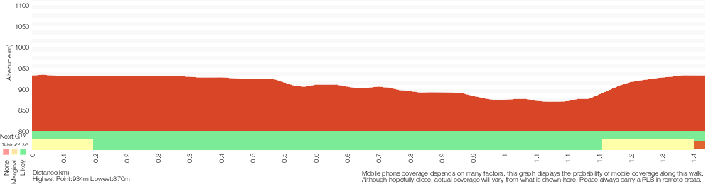
Analysis and summary of the altitude variation on the Lyrebird Dell and Pool of Siloam Circuit
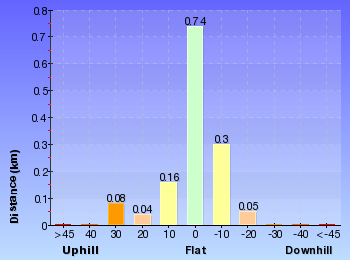
Overview of this walks grade – based on the AS 2156.1 – 2001
Under this standard, a walk is graded based on the most difficult section of the walk.
| Length | 1.4 km | ||
| Time | 1 Hr | ||
| . | |||
| Grade 3/6 Moderate track |
AS 2156.1 | Gradient | Short steep hills (3/6) |
| Quality of track | Formed track, with some branches and other obstacles (3/6) | ||
| Signs | Directional signs along the way (3/6) | ||
| Experience Required | No experience required (1/6) | ||
| Weather | Storms may impact on navigation and safety (3/6) | ||
| Infrastructure | Limited facilities, not all cliffs are fenced (3/6) |
Some more details of this walks Grading
Here is a bit more details explaining grading looking at sections of the walk
Gradient
Around 880m of this walk has short steep hills, whilst the remaining 490m has gentle hills with occasional steps.
Quality of track
Around 1.1km of this walk follows a clear and well formed track or trail, whilst the remaining 230m follows a formed track, with some branches and other obstacles.
Signs
Around 1.1km of this walk is clearly signposted, whilst the remaining 230m has directional signs at most intersection.
Experience Required
This whole walk, 1.4km requires no previous bushwalking experience.
weather
Around 1.1km of this walk is not usually affected by severe weather events (that would unexpectedly impact safety and navigation), whilst the remaining 250m is affected by storms that may impact your navigation and safety.
Infrastructure
Around 1.1km of this walk is close to useful facilities (such as fenced cliffs and seats), whilst the remaining 230m has limited facilities (such as not all cliffs fenced).
Similar walks
A list of walks that share part of the track with the Lyrebird Dell and Pool of Siloam Circuit walk.
538 m Return
30 mins
Moderate track
600 m Return
30 mins
Moderate track
1.6 km One way
1 Hr
Moderate track
1.8 km One way
1 hr 15 mins
Moderate track
Other Nearby walks
A list of walks that start near the Lyrebird Dell and Pool of Siloam Circuit walk.
260 m Return
15 mins
Moderate track
6.6 km One way
4 hrs
Hard track
222 m Return
15 mins
Moderate track
752 m Return
30 mins
Moderate track
2 km Circuit
1 Hr
Moderate track
954 m Return
30 mins
Moderate track
432 m Return
15 mins
Easy track
570 m Return
20 mins
Moderate track
150 m Return
15 mins
Moderate track
4.4 km One way
3 hrs 45 mins
Hard track
9.4 km Circuit
5 hrs 30 mins
Hard track
Plan your trip to and from the walk here
The Lyrebird Dell and Pool of Siloam Circuit walk starts and ends at the Gordon Falls Reserve (gps: -33.724727, 150.33273)
Your transport options to Gordon Falls Reserve are by;
![]() Bus. (get details)
Bus. (get details)
![]() Car. There is free parking available.
Car. There is free parking available.
(get details)
Short URL = http://wild.tl/ldposc
Gallery images
There are other downloads I am still working on.
You will probably need to login to access these — still all free.
* KML (google earth file)
* GPX (GPS file)
Special Maps/ brochures
* A3 topo maps
* PDF with Lands Topo map base
* PDF with arial image (and map overlay)
I wanted to get the main site live first, this extra stuff will come in time.
Happy walking
Matt 🙂
Comments