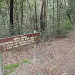
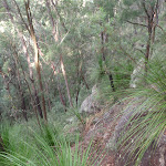
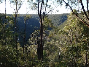
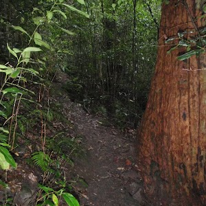
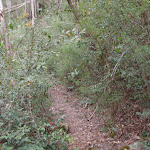
This walk offers a diverse range of vegetation and sights along its course. Passing Martins Falls and below Martins Lookout, the walk takes in some amazing views as it climbs up and down the ridge lines, above the many creeks and gullies. A walk to test your legs and your camera.* This walk passes through very remote areas and sections have no visible track. At least one person in your group should have training and experience in off track walking and navigation. Even with these notes and a GPS these extra skills and equipment are required.
Springwood to Blaxland Station
And Walk
Springwood to Blaxland Station


6 hrs
13.5 km One way

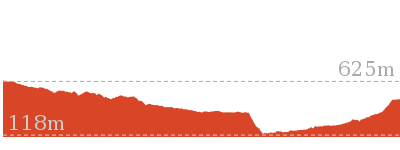
628 m
Experienced only


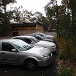


Springwood
Springwood, along the Great Western Highway, is the second largest town in the Blue Mountains. Springwood also takes the title for the oldest railway station in the Blue Mountains. There are a variety of shops in Springwood, with quite a few cafes, bakeries and two historic hotels. Springwood was named by Governor Macquarie, when his wife and he stopped for water from a deep glen spring, in 1815. It seems aptly named, with many springs and creeks leading away from the ridge at Springwood, including Sassafras Gully, Magdala Creek and Glenbrook Creek. More info.
(0km) Springwood Station → Int. Springwood Ave and Fairy Dell Reserve

270 m
5 mins
4m
-11m
Very easy
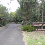
From Springwood Station, the walk crosses the road at the pedestrian crossing and turns left. The walk continues past the shop front for about 150 metres before turning right at a quadrangle, which leads the walk down through a car park. The walk passes through the car park and crosses Macquarie Rd, to the ‘Fariy Dell’ sign[4].
(0.27km) Int. Springwood Ave and Fairy Dell Reserve → Fairy Dell Reserve picnic area
150 m
3 mins
0m
-21m
Easy track
Continue straight: From the ‘Fairy Dell, 49 Springwood Ave’ sign[5], the walk heads downhill into the reserve (along the smaller road), past the signs. The walk winds down past the units (on the left) to the bottom of the road. The walk continues on the left side of the cul-de-sac, to a grassy area with picnic tables.
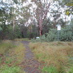
Fairy Dell Reserve picnic area
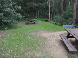
Fairy Dell Reserve picnic area is a quiet and shady terraced garden at the head of the Magdala Gully. Fairy Dell is situated just south of Springwood in the Lower Blue Mountains. The picnic area has numerous tables, parking and a grassy area for the kids to play. The Fairy Dell Reserve Picnic area is also the starting point for a number of walks down to Magdala Creek, Picnic Point and nearby Lawson Lookout.
(0.41km) Fairy Dell Reserve picnic area → Int. Fairy Dell and Picnic Point Tracks
390 m
9 mins
5m
-44m
Hard track
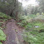
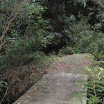
Veer left: From the picnic area, the walk follows the ‘Sassafras Gully’ sign down the stairs. The walk quickly passes the vandalised building (which has since been reported as demolished by another walker), then a map sign before meeting a creek. The walk keeps the creek on the right and soon comes to a bridge with direction signs.
(0.8km) Int. Fairy Dell and Picnic Point Tracks → Picnic Point
160 m
6 mins
33m
-2m
Hard track
Turn right: From the intersection, the walk crosses the bridge, following the ‘Picnic Point’ signs[6]. The walk immediately climbs many stairs which wind up to a the picnic shelter and grass area of Picnic Point. At the end of this side trip, retrace your steps back to the main walk then Turn right.
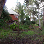
Picnic Point

Picnic Point, in Springwood, Blue Mountains, is a quiet, grassy clearing tucked behind the houses above Magdala Creek. The area has a gazebo, picnic table and water tank (water needs to be treated). The clearing has a track leading down to many popular walks, with Lawson’s Lookout and Fairy Dell Reserves nearby.
(0.8km) Int. Fairy Dell and Picnic Point Tracks → Int. Lawsons Lookout Trk and Fairy Dell Trk
140 m
3 mins
1m
-13m
Moderate track
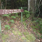
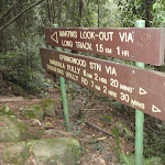
Continue straight: From the intersection at the bridge, the walk heads in the direction of the ‘Perch Ponds’ arrow[7], keeping the creek on the right of the track. The walk soon comes to a ‘Lawson’s Lookout’ sign[ref img=146352, above a cascade in the creek.
(0.94km) Int. Lawsons Lookout Trk and Fairy Dell Trk → Lawsons Lookout
410 m
11 mins
39m
-11m
Hard track
Turn left: From the intersection, the walk follows the direction of the ‘Lawsons Lookout’ signs[8], up the hill. The track heads up to a rocky outcrop, where the track turns back on itself and steps through some bushes to the rocky surface of the lookout. At the end of this side trip, retrace your steps back to the main walk then Turn left.
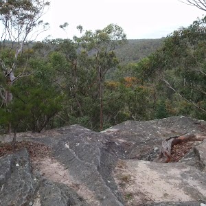
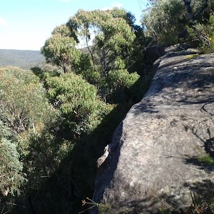
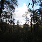
Lawsons Lookout
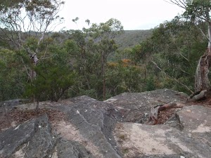
Lawsons Lookout, in Springwood, Blue Mountains, is an unfenced rockshelf overlooking the wonderful Magdala Creek valley. The lookout is most easily accessed from Raymond Rd.
(0.94km) Int. Lawsons Lookout Trk and Fairy Dell Trk → Int. Magdala Ck and Magdala Falls trks
3.2 km
1 hr 7 mins
92m
-181m
Hard track
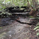
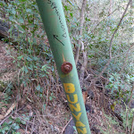
Continue straight: From the intersection, the walk follows the direction of the ‘Perch Ponds’ sign, keeping the creek on the right. The track crosses the creek many times, passing a number of caves. The track passes a burnt ‘Perch Ponds’ sign[9] as it crosses a creek to immediately come to an intersection (with arrows engraved in the rocks[10]).
Turn right: From the intersection, the walk follows the arrows engraved in the rock, keeping the creek to the right. The walk winds down the hillside then crosses the creek, continuing to follow the creek (now on the left) to a ‘Magdala Falls’ sign.
Turn right: From the intersection, the walk follows the arrows engraved in the rock, keeping the creek to the right. The walk winds down the hillside then crosses the creek, continuing to follow the creek (now on the left) to a ‘Magdala Falls’ sign.
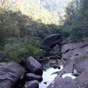
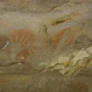
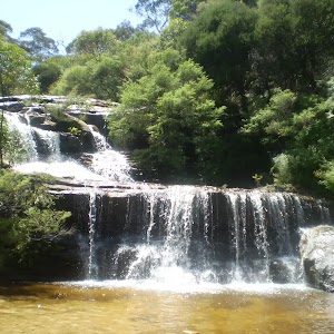
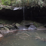
Magdala Falls

Magdala Falls is a disappointing set of falls. The view from the steep hillside doesn’t show any of the falls, but instead lets you hear the water cascade into the pool below. A red-stained rock above the pool can be seen through the dense foliage of the trees.
(4.18km) Int. Magdala Ck and Magdala Falls trks → Int. Martins Falls and Magdala Ck trks
300 m
7 mins
13m
-25m
Hard track
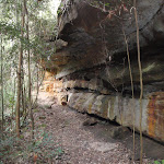
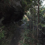
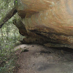
Continue straight: From the intersection, the walk keeps the creek on the left as it heads down the gully. The walk winds down the hill, passing a few rock overhangs as it leads to a ‘Martins Lookout’ sign.
(4.47km) Int. Martins Falls and Magdala Ck trks → Behind Martins Falls
30 m
1 mins
1m
-2m
Hard track
Turn left : From the intersection, the walk heads to the left of the ‘Martins Falls’ sign (towards the falls). The walk skirts around the edge of the valley, coming under the rock overhang of the falls, and then arriving behind the falls. At the end of this side trip, retrace your steps back to the main walk then Turn left.
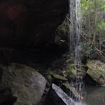
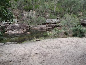
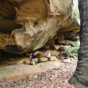
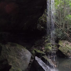
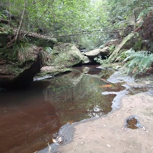
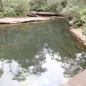
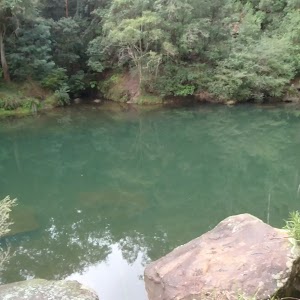
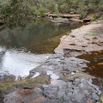
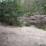
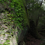
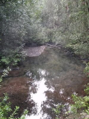
Martins Falls

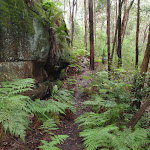
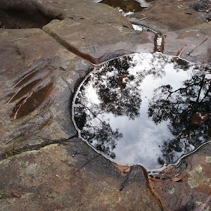
Martins Falls are at a rock overhang on Magdala Creek, near Springwood, almost 400m upstream from the Glenbrook Creek junction. The water falls off a rock platform, over the overhang into a large pond. There is a faint track leading behind the falls, giving a different perspective of the pond and falls – extra care is required. This is a lovely area to enjoy the cool temperatures on warmer days, and is more spectacular after recent rain.
(4.47km) Int. Martins Falls and Magdala Ck trks → Perch Ponds camping area
380 m
10 mins
14m
-63m
Hard track
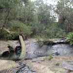
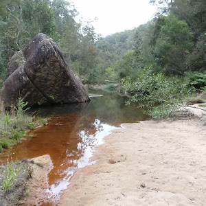
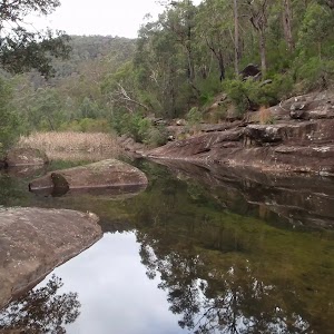
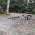
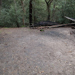
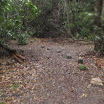
Perch Ponds Campsite
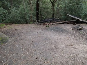
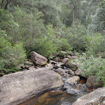
Perch Ponds is a lovely waterhole, with a clearing suitable to pitch a tent, located at the junction of Magdala Creek and Glenbrook Creeks. The meeting of the two creek provides a relaxing sound of rushing water and a cool spot to rest on warmer days. The campsite is a flat area above the pool marked with a fire scar. A great shady and quiet area for a camp. There are no facilities and water from the creek needs to be treated.
(4.86km) Perch Ponds camping area → Martins camping area
1.2 km
27 mins
51m
-67m
Hard track
Turn left: From the intersection, the walk follows the direction of the ‘Martins Lookout’ sign across the campground clearing to an arrow bolted to a tree. The walk follows this arrow down the hill and across the creek, and then follows creek, keeping it on the right. The walk leads up the hill away from the creek to a signposted intersection for ‘Martins Lookout’.
Veer right: From the intersection, the walk follows direction of the ‘Long Track’ sign, down the hill. The track winds down near the creek and passes a sandy beach access before soon entering a second clearing.
Veer right: From the intersection, the walk follows direction of the ‘Long Track’ sign, down the hill. The track winds down near the creek and passes a sandy beach access before soon entering a second clearing.
Martins campsite
Martins campsite is an unofficial camping area beside Glenbrook Creek. The camping area is a sandy clearing, opposite cliffs on the other bank. The camping area is situated below Martins Lookout, with Bunyan Lookout up the ridge on the opposite hillside. A quiet and shaded location which can give a great night’s sleep.
(6.03km) Martins camping area → Int. Martins Lookout and Bunyan Lookout Trk
230 m
6 mins
13m
-14m
Moderate track
Turn left: From the fireplace, the walk heads along the creek bank, keeping the creek near and on the right. The walk then tends left, up the hill to the intersection and pole without a sign.
(6.26km) Int. Martins Lookout and Bunyan Lookout Trk → Martins Lookout
530 m
26 mins
180m
-2m
Hard track
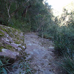
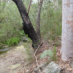
Veer left: From the intersection, the walk heads up the stairs and soon begins zigzagging up the hillside for a short time, coming to be under a cliff line. The track heads up stairs which head through the cliffs and winds steeply up to the next set of stairs. The track heads under many wonderful rock overhangs, as it winds its way using stairs to come up to Martins Lookout. At the end of this side trip, retrace your steps back to the main walk then Turn left.
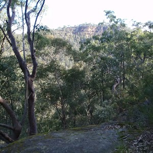
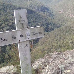
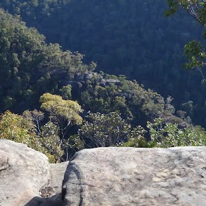
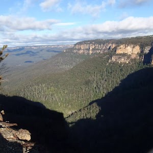
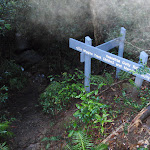
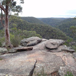
Martins Lookout
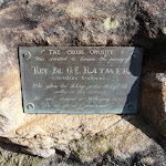
Martin’s Lookout is an unfenced view on the rim of the plateau, south of Valley Heights. There are views across and up the Glenbrook Creek, and to the Lost Worlds lookout (on the opposite cliffs) which features a small white crucifix. This cross is in memory of Rev. Raymer who was an avid bushwalker in the area. The plaque in the rock at Martin’s Lookout is directly opposite this cross.
(6.26km) Int. Martins Lookout and Bunyan Lookout Trk → Bunyan Lookout
960 m
38 mins
222m
-25m
Experienced only
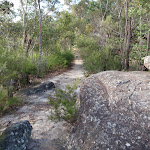
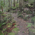
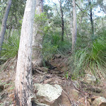
Veer right: From the intersection, the walk follows the ‘Bunyan Lkt’ post down the stairs. The walk soon meets the creek and turns left, following the creek for a short distance before crossing at an opening in the shrubs around the creek. From here, the walk follows the cairns (rock stacks) across creek flats before climbing the hill to the base of a small cliff line. At one point beneath the cliff line, the walk ducks through a hole in the rock, then winds up through boulders, following more cairns. The walk continues up the hill, passing through a few more rocky outcrops to reach the informal, unfenced Bunyan Lookout, in a clearing near the cliff line.
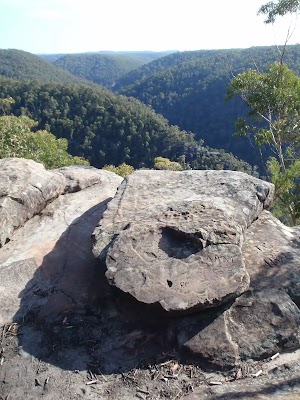
Bunyan Lookout
Bunyan Lookout is an large, unfenced sandstone platform overlooking the Glenbrook Creek valley. Behind the lookout, there is a small sandy clearing, big enough for a few tents. The lookout spans across Glenbrook Creek and sandstone cliffs of the valley.
(7.22km) Bunyan Lookout → Int. Bunyan Lookout Trk and Lost Worlds Trk
570 m
10 mins
18m
-7m
Moderate track
Turn sharp right: From Bunyan Lookout, the walk heads back into the clearing behind the unfenced cliff line and turns left at the cairn (if you head down into the valley, you have gone the wrong way). The walk meanders through the heath for a short time before coming to a red painted stump, on the right of the track.
(7.78km) Int. Bunyan Lookout Trk and Lost Worlds Trk → Lost Worlds Lookout
570 m
11 mins
20m
-13m
Moderate track
Turn right: From the red stump intersection, the walk follows the ‘Lost Worlds’ sign up the small hill. The walk winds through the bush for a short time then crosses a rocky surface. The track then leaves the rocky surface briefly to return to a similar rock surface with a white crucifix on the edge of the cliff. At the end of this side trip, retrace your steps back to the main walk then Turn right.
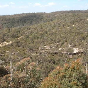
Lost Worlds Lookout
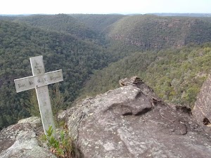
Lost Worlds Lookout is a cliff edge marked by a cross. The cross commemorates the Rev. Raymer who was a prominent bushwalker in the area, and has been commemorated by a plaque at Martins Lookout across the valley. The lookout views Glenbrook Creek valley below, the surrounding cliffs and down to Penrith in the west.
(7.78km) Int. Bunyan Lookout Trk and Lost Worlds Trk → Int. Bunyan Lookout Trk and St Helena Trk
590 m
10 mins
4m
-10m
Moderate track
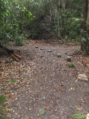
Continue straight: From the intersection, the walk heads in a southerly direction away from the red stump, keeping it behind on the right of the track. The walk winds through the bush, crossing a few sandy areas that lead to a small cairn marking the intersection, on the left of the track.
(8.37km) Int. Bunyan Lookout Trk and St Helena Trk → St Helena Ridge Lookout
2.8 km
49 mins
9m
-122m
Hard track
Veer left: From the intersection, this walk heads south east along track soon leading downhill. The walk meanders through the heath for quite some time. The walk nears a cliff line on the left, which it continues near for a short time before opening out onto a rocky outcrop with a view across to houses on the opposite hill (just before the steep downhill section).
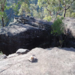
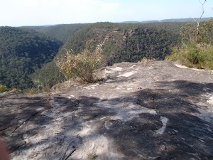
St Helena Ridge Lookout
St Helena Ridge Lookout, does not have the clearest view or the most spectacular scenery. However, it is a great place to rest before continuing on your way.
(11.18km) St Helena Ridge Lookout → Int. Waterfall and ridge trk
360 m
18 mins
4m
-122m
Experienced only
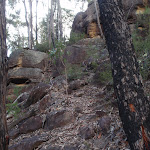
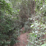
Continue straight: From St Helena Ridge lookout, the walk follows a very faint track initially very steeply down off the rock platform, The track initially tends a little to the left to then follow the main ridge line down. The track soon becomes much less steep (and a little clearer) when after about 100m the faint track bends right at another rocky outcrop. Here the walk leads off the side of the ridge to then wind down through the rocky outcrops and continue down through the scrub for about 180m until just before Glenbrook Creek where this walk comes to an un-signposted intersection.
(11.53km) Int. Waterfall and ridge trk → St Helena waterfall
160 m
3 mins
4m
-6m
Experienced only
Veer left: From the intersection, the walk heads upstream, keeping the creek on the right. The track undulates along the bank, passing a few large boulders in the creek before coming to a sandy beach at a bend in the creek.
Continue straight: From the beach, the walk heads across the sand bar (covered in reeds) to come within ear-shot of the waterfall, located behind the inlet on the creek. The walk passes through the sandy, shallow section of the creek then walks up the bank and around to the waterfall. At the end of this side trip, retrace your steps back to the main walk then Continue straight.
Continue straight: From the beach, the walk heads across the sand bar (covered in reeds) to come within ear-shot of the waterfall, located behind the inlet on the creek. The walk passes through the sandy, shallow section of the creek then walks up the bank and around to the waterfall. At the end of this side trip, retrace your steps back to the main walk then Continue straight.
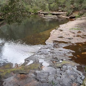
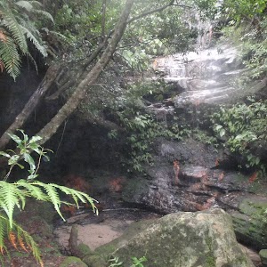
St Helenas waterfall

St Helenas waterfall is a small fall, flowing from a side creek into Glenbrook Creek. It is rather unimpressive unless there has been recent rainfall. The water cascades down a nice rock face, among the sassafras trees and mossy rocks.
(11.53km) Int. Waterfall and ridge trk → Blaxland Library Carpark
1.4 km
34 mins
150m
-28m
Experienced only
Turn right: From the intersection, the walk heads downstream, keeping the creek on the left. After approximately 10m, the walk comes to a bushy creek crossing and winds over the rocks and through the bushes. Following this, the walk keeps the creek on the right whilst winding downstream. The track soon arrives at an intersection, which is a sandy area with rocks and stairs leading up the hill.
Turn left : From the large boulder, this walk heads up the hill and climbs the stone steps steeply, with a number of pink ribbons marking the initial track. The track continues steeply (eroded in places) up the hill and winds its way up to the un-signposted T-intersection.
Turn sharp right: From the intersection[13], this walk heads along the mostly flat track along the side of the hill, keeping the valley to your right. Soon the track leads to another intersection at the base of more stone steps, and a rock wall (on the left) that has ‘Florabella Pass’ engraved in it[14].
Continue straight: From the intersection, the walk heads around the boulder (which is on the left) and soon meets a set of stairs, to the left of a ‘Pippas Pass’ sign[15] in a tree.
Turn right: From the intersection[16], this walk follows the ‘Pippas Pass’ sign[17] (that is about 2m up a tree) gently downhill along the track, directly away from the rockface, keeping the main valley to your right. The track winds along the side of the hill for about 100m
to then climb up a set of sandstone steps just past a shallow sandstone overhang[18]. From here the track gently undulates along the side of the hill (with a steep valley to your right[19]) for about 300m to lead gently down and cross the usually small creek in the shaded valley[20]. Just after crossing this creek[21], the track bends left to head gently up through the valley along the base of a few natural sandstone walls[22] for about 200m, where the the track becomes rocky and starts to climb a bit more steeply. The track then leads up through a cleft in the rock[23] then about 60m later comes to a unsignposted three-way intersection (with the track on the left crossing the creek), marked with a smooth bark Angophera[24].
Turn left: From the intersection[25], this walk crosses the sandstone platform and creek[26]. Here the track winds gently uphill for about 40m to cross a smaller often dry creek [27] where the track continues uphill for another 30m to pass a grafittied sandstone overhang (on your left)[28]. The track continues gently uphill and bends right to cross a sandstone rock platform and small creek[29] to almost immediately come to a faint intersection with a track in the tall heath[30]. Here the walk turns left and heads uphill for for about 50m where the track then leads up some steps to come to the base of a sandstone cliff and smaller overhang[31]. Here the track bends left and and continues along the side of the hill for another 15m to pass a larger and more grafittied sandstone overhang[32]. From here the track continues to wind more steeply uphill for about 80m before turning left and following a wider track (away from the houses) and into the lower car park of Blaxland library just past the ‘Bushcare site’ information sign[33]. Here this walk turns right to head up to the library and main car park[34].
(12.93km) Blaxland Library Carpark → Blaxland shops
460 m
9 mins
28m
-9m
Very easy
Turn left: From the Blaxland Library car park[35], this walk heads up the ramp on the side of the building[36] then follows the back deck behind the library and community centre[37]. On the far side of the building, this walk follows the bitumen footpath[38] footpath uphill to turn left at the ‘Blaxland Civic Centre’[39] sign onto the footpath beside Hope St. This walk follows the footpath uphill for about 150m before turning right to cross Hope St at the traffic calming device[40]. Here the walk bends left and crosses a car park entrance[41], then soon turns right into ‘Station St’[42]. Here the walk heads up the footpath to cross another car park entrance[43] then onto the pedestrian lane way that leads between the buildings, under the foot bridge[44] to the main footpath, just before the Great Western Highway, among the Blaxland shops.
Blaxland
Blaxland, found along the Great Western Highway, is one of the larger towns of the Lower Blue Mountains. The town has a number of shops and petrol station all lining the highway which lies between the town and train station. Wascoe was the original name of Blaxland until 1914 when it was renamed after Gregory Blaxland who was one of the explorers who found the route across the mountains for the colony . The Blaxland community hosts a number of events during the month of September. More info.
(13.39km) Blaxland Shops → Blaxland Station
70 m
1 mins
0m
0m
Very easy
Turn left: From the footpath, the walk uses the stairs or ramp to climb onto the pedestrian bridge. The walk then crosses the bridge over the Great Western Highway and then heads down onto Blaxland Station.
Maps for the Springwood to Blaxland Station walk
You can download the PDF for this walk to print a map.
These maps below cover the walk and the wider area around the walk, they are worth carrying for safety reasons.
| Springwood | 1:25 000 Map Series | 90304S SPRINGWOOD | NSW-90304S |
| Penrith | 1:25 000 Map Series | 90303N PENRITH | NSW-90303N |
| Penrith | 1:100 000 Map Series | 9030 PENRITH | 9030 |
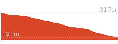
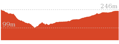
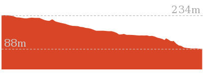
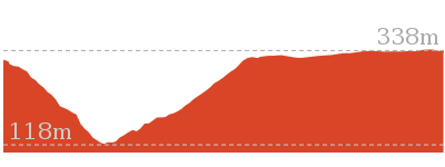
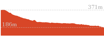
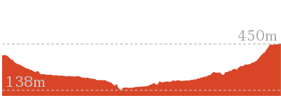
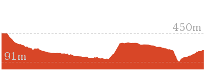
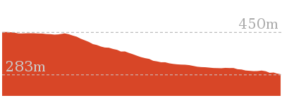
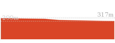
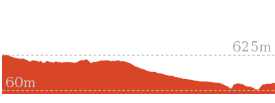
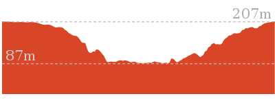
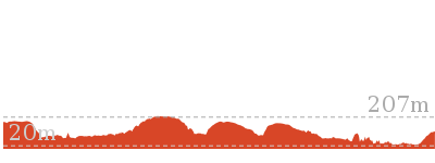
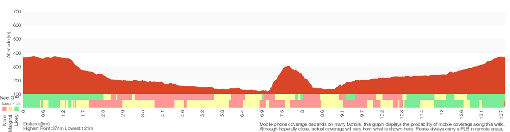
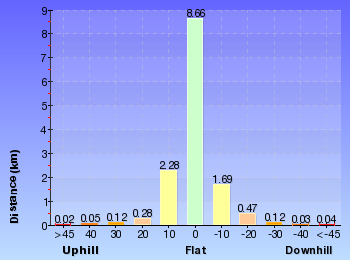
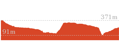
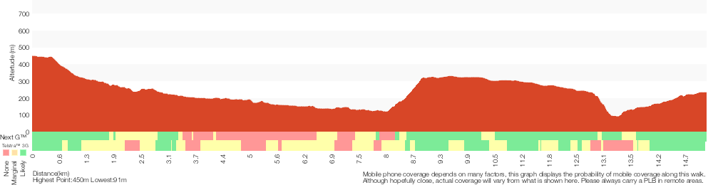
Cross sectional view of the Springwood to Blaxland Station bushwalking track
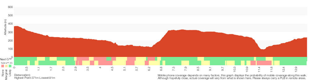
Analysis and summary of the altitude variation on the Springwood to Blaxland Station
Overview of this walks grade – based on the AS 2156.1 – 2001
Under this standard, a walk is graded based on the most difficult section of the walk.
| Length | 13.5 km | ||
| Time | 6 hrs | ||
| . | |||
| Grade 5/6 Experienced only |
AS 2156.1 | Gradient | Very steep (4/6) |
| Quality of track | Rough unclear track (5/6) | ||
| Signs | No directional signs (5/6) | ||
| Experience Required | Moderate level of bushwalking experience recommended (4/6) | ||
| Weather | Storms may impact on navigation and safety (3/6) | ||
| Infrastructure | No facilities provided (5/6) |
Some more details of this walks Grading
Here is a bit more details explaining grading looking at sections of the walk
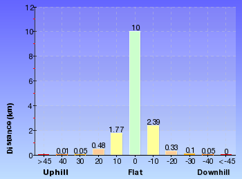
Gradient
5km of this walk is very steep and another 4.3km has gentle hills with occasional steps. Whilst another 3.3km has short steep hills and the remaining 800m is flat with no steps.
Quality of track
7km of this walk follows a rough track, where fallen trees and other obstacles are likely and another 3.9km follows a formed track, with some branches and other obstacles. Whilst another 1.4km follows a rough unclear track and a 940m section follows a smooth and hardened path. The remaining 55m follows a clear and well formed track or trail.
Signs
7km of this walk has minimal directional signs and another 4.6km has directional signs at most intersection. Whilst another 1.1km Has no directional signs and the remaining 940m is clearly signposted.
Experience Required
12km of this walk requires no previous bushwalking experience and another 1.3km requires some bushwalking experience. The remaining (110m) requires a leader a with moderate level of bushwalking experience.
weather
Around 12km of this walk is not usually affected by severe weather events (that would unexpectedly impact safety and navigation), whilst the remaining 1.3km is affected by storms that may impact your navigation and safety.
Infrastructure
8km of this walk has limited facilities (such as cliffs not fenced, significant creeks not bridged) and another 4.3km has limited facilities (such as not all cliffs fenced). Whilst another 1.3km is close to useful facilities (such as fenced cliffs and seats) and the remaining 100m has no facilities provided.
Similar walks
A list of walks that share part of the track with the Springwood to Blaxland Station walk.
1.2 km Return
1 hr 30 mins
Hard track
2.6 km Circuit
1 hr 30 mins
Hard track

2.7 km Return
1 hr 30 mins
Hard track
2.9 km One way
2 hrs
Hard track
3.1 km Return
3 hrs 30 mins
Experienced only
4 km Return
2 hrs
Hard track
4.3 km Circuit
2 hrs 30 mins
Hard track
5.4 km Return
3 hrs 30 mins
Experienced only
6 km One way
3 hrs
Hard track
9 km Return
4 hrs
Hard track
10.5 km Circuit
4 hrs 15 mins
Hard track
11.5 km One way
5 hrs
Hard track
13.8 km Circuit
6 hrs 30 mins
Hard track
15.2 km One way
2 Days
Experienced only

15.9 km One way
7 hrs
Experienced only
18.3 km One way
7 hrs 15 mins
Experienced only
23.4 km One way
2 Days
Experienced only
Other Nearby walks
A list of walks that start near the Springwood to Blaxland Station walk.
202 m Return
15 mins
Moderate track
3.5 km Return
2 hrs
Hard track
6.1 km One way
3 hrs
Hard track
180 m Return
15 mins
Moderate track
8.6 km Return
3 hrs 30 mins
Hard track
29.6 km One way
3 Days
Hard track
1 km Return
30 mins
Moderate track
4.1 km Circuit
2 hrs
Moderate track
16.6 km Circuit
2 Days
Experienced only
18.8 km One way
2 Days
Very experienced only
8.6 km Circuit
5 hrs
Hard track

5.6 km Return
2 hrs
Moderate track
Plan your trip to and from the walk here
The Springwood to Blaxland Station walk starts at the Springwood Station (gps: -33.699102, 150.5638)
Your transport options to Springwood Station are by;
![]() Train. (get details)
Train. (get details)
![]() Bus. (get details)
Bus. (get details)
![]() Car. There is free parking available.
Car. There is free parking available.
(get details)
![]() Train. (get details)
Train. (get details)
The Springwood to Blaxland Station ends at the Blaxland Station (gps: -33.743785, 150.60987)
Your transport options to Blaxland Station are by;
![]() Bus. (get details)
Bus. (get details)
![]() Car. There is free parking available.
Car. There is free parking available.
(get details)


Short URL = http://wild.tl/stbs
Gallery images
There are other downloads I am still working on.
You will probably need to login to access these — still all free.
* KML (google earth file)
* GPX (GPS file)
Special Maps/ brochures
* A3 topo maps
* PDF with Lands Topo map base
* PDF with arial image (and map overlay)
I wanted to get the main site live first, this extra stuff will come in time.
Happy walking
Matt 🙂
Martins Lookout Loop Walk
And Walk
Martins Lookout Loop Walk

6 hrs 30 mins
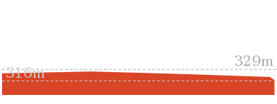
13.8 km Circuit
842 m
Hard track


Springwood
Springwood, along the Great Western Highway, is the second largest town in the Blue Mountains. Springwood also takes the title for the oldest railway station in the Blue Mountains. There are a variety of shops in Springwood, with quite a few cafes, bakeries and two historic hotels. Springwood was named by Governor Macquarie, when his wife and he stopped for water from a deep glen spring, in 1815. It seems aptly named, with many springs and creeks leading away from the ridge at Springwood, including Sassafras Gully, Magdala Creek and Glenbrook Creek. More info.
(0km) Springwood Station → No. 18 Sassafras Gully Rd
1.2 km
23 mins
35m
-38m
Very easy
From Springwood Station, the walk crosses the pedestrian crossing and turns right, passing the shop fronts. The walk continues along Macquarie Rd and turns left onto Homedale St. At the bottom of Homedale St, the walk turns right onto Valley Rd, and then left onto Sassafras Gully Rd. The walk continues to the bottom of Sassafras Gully Rd, in front of house number 18.
(1.19km) No. 18 Sassafras Gully Rd → Int. Victory and Sassafras Gully Trks
1.4 km
33 mins
28m
-186m
Moderate track
Veer left: From the end of Sassafras Gully Rd, the walk heads down the hill along the fenceline of house No. 18. The walk passes two signs for ‘Sassafras Gully’ as it winds to the right at a rock outcrop and down to an unsignposted intersection.
Turn left: From the intersection, the walk heads down the hill, keeping the rock outcrop on the left. The walk passes a track on the left (which heads over the rock outcrop) and turns down the hill. As the walk winds down the hill, a few smaller tracks are passed before nearing a creek. The walk crosses the creek a few times as it heads down the gully to a larger creek junction. The walk crosses the junction, then follows the larger gully, soon coming to a ‘Sassafras Gully Rd’ sign (pointing back the way you came)[4].
Turn left: From the intersection, the walk heads down the hill, keeping the rock outcrop on the left. The walk passes a track on the left (which heads over the rock outcrop) and turns down the hill. As the walk winds down the hill, a few smaller tracks are passed before nearing a creek. The walk crosses the creek a few times as it heads down the gully to a larger creek junction. The walk crosses the junction, then follows the larger gully, soon coming to a ‘Sassafras Gully Rd’ sign (pointing back the way you came)[4].
(2.59km) Int. Victory and Sassafras Gully Trks → Perch Ponds camping area
3.1 km
1 hr 5 mins
80m
-147m
Hard track
Continue straight: From the intersection, the walk heads down across the creek in the direction of the ‘To Wiggins Track’ sign[5]. The walk winds along the hillside, keeping the creek on the right, passing a blue track marker[6] which directs the walk to the other side of the creek. The walk now keeps the creek on the left as it winds up to a ‘Perch Ponds, Springwood Stn’ sign[7].
Veer right: From the intersection, the walk follows the direction of the ‘Perch Ponds’ sign[8] across the hillside. The walk soon nears the creek on the left, then undulates above it for a short while. The track crosses a steeply banked creek junction, then continues following the main creek (which is on the left). The walk stays near this creek, coming into a campground clearing with large boulders.
Continue straight: From the campground clearing, the walk exits the clearing, keeping the main creek to the right, and immediately crosses a side creek. The walk keeps the main creek on the right as it slowly climbs the hillside. The track then heads downhill, passing under a few rock overhangs and soon entering the campground clearing of ‘Perch Ponds’.
Perch Ponds Campsite
Perch Ponds is a lovely waterhole, with a clearing suitable to pitch a tent, located at the junction of Magdala Creek and Glenbrook Creeks. The meeting of the two creek provides a relaxing sound of rushing water and a cool spot to rest on warmer days. The campsite is a flat area above the pool marked with a fire scar. A great shady and quiet area for a camp. There are no facilities and water from the creek needs to be treated.
(5.69km) Perch Ponds camping area → Martins camping area
1.2 km
27 mins
51m
-67m
Hard track
Continue straight: From the intersection, the walk follows the direction of the ‘Martins Lookout’ sign across the campground clearing to an arrow bolted to a tree. The walk follows this arrow down the hill and across the creek, and then follows creek, keeping it on the right. The walk leads up the hill away from the creek to a signposted intersection for ‘Martins Lookout’.
Veer right: From the intersection, the walk follows direction of the ‘Long Track’ sign, down the hill. The track winds down near the creek and passes a sandy beach access before soon entering a second clearing.
Veer right: From the intersection, the walk follows direction of the ‘Long Track’ sign, down the hill. The track winds down near the creek and passes a sandy beach access before soon entering a second clearing.
Martins campsite
Martins campsite is an unofficial camping area beside Glenbrook Creek. The camping area is a sandy clearing, opposite cliffs on the other bank. The camping area is situated below Martins Lookout, with Bunyan Lookout up the ridge on the opposite hillside. A quiet and shaded location which can give a great night’s sleep.
(6.86km) Martins camping area → Int. Martins Lookout and Bunyan Lookout Trk
230 m
6 mins
13m
-14m
Moderate track
Turn left: From the fireplace, the walk heads along the creek bank, keeping the creek near and on the right. The walk then tends left, up the hill to the intersection and pole without a sign.
(7.09km) Int. Martins Lookout and Bunyan Lookout Trk → Bunyan Lookout
960 m
38 mins
222m
-25m
Experienced only
Veer right: From the intersection, the walk follows the ‘Bunyan Lkt’ post down the stairs. The walk soon meets the creek and turns left, following the creek for a short distance before crossing at an opening in the shrubs around the creek. From here, the walk follows the cairns (rock stacks) across creek flats before climbing the hill to the base of a small cliff line. At one point beneath the cliff line, the walk ducks through a hole in the rock, then winds up through boulders, following more cairns. The walk continues up the hill, passing through a few more rocky outcrops to reach the informal, unfenced Bunyan Lookout, in a clearing near the cliff line. At the end of this side trip, retrace your steps back to the main walk then Turn right.
Bunyan Lookout
Bunyan Lookout is an large, unfenced sandstone platform overlooking the Glenbrook Creek valley. Behind the lookout, there is a small sandy clearing, big enough for a few tents. The lookout spans across Glenbrook Creek and sandstone cliffs of the valley.
(7.09km) Int. Martins Lookout and Bunyan Lookout Trk → Martins Lookout
530 m
26 mins
180m
-2m
Hard track
Veer left: From the intersection, the walk heads up the stairs and soon begins zigzagging up the hillside for a short time, coming to be under a cliff line. The track heads up stairs which head through the cliffs and winds steeply up to the next set of stairs. The track heads under many wonderful rock overhangs, as it winds its way using stairs to come up to Martins Lookout.
Martins Lookout
Martin’s Lookout is an unfenced view on the rim of the plateau, south of Valley Heights. There are views across and up the Glenbrook Creek, and to the Lost Worlds lookout (on the opposite cliffs) which features a small white crucifix. This cross is in memory of Rev. Raymer who was an avid bushwalker in the area. The plaque in the rock at Martin’s Lookout is directly opposite this cross.
(7.62km) Martins Lookout → Int. Martins Falls and Magdala Ck trks
1.7 km
1 Hr
160m
-273m
Hard track
Turn right: From the intersection, the walk heads away from the cliff edge, keeping the view on the left. The walk continues along the hillside and comes to a three-way marked with a pole (without a sign- on the left).
Turn left: From the intersection, the walk heads towards the bottom of the rocky outcrop. The track heads across the hillside under the rocky outcrop and then turns left, descending the hill steeply. The walk winds down the hill for a short time to a signposted intersection.
Turn right: From the intersection, the walk follows the direction of the ‘Springwood Stn Via…’ sign across the hillside. The walk keeps the valley to the left as it winds down near the creek, on the left. The walk continues down across the creek to immediately lead up the hill into the clearing of Perch Ponds. The walk crosses the clearing to the signs at the other side.
Turn right: From Perch Ponds, the walk follows the ‘Magdala Gully-Fairy Dell’ sign[9], up the hill. The track winds up the hillside for a short time, keeping the creek on the right, then comes to a ‘Martins Falls’ sign[10].
(9.33km) Int. Martins Falls and Magdala Ck trks → Behind Martins Falls
30 m
1 mins
1m
-2m
Hard track
Turn right: From the intersection, the walk heads to the left of the ‘Martins Falls’ sign (towards the falls). The walk skirts around the edge of the valley, coming under the rock overhang of the falls, and then arriving behind the falls. At the end of this side trip, retrace your steps back to the main walk then Turn right.
Martins Falls
Martins Falls are at a rock overhang on Magdala Creek, near Springwood, almost 400m upstream from the Glenbrook Creek junction. The water falls off a rock platform, over the overhang into a large pond. There is a faint track leading behind the falls, giving a different perspective of the pond and falls – extra care is required. This is a lovely area to enjoy the cool temperatures on warmer days, and is more spectacular after recent rain.
(9.33km) Int. Martins Falls and Magdala Ck trks → Int. Lawsons Lookout Trk and Fairy Dell Trk
3.5 km
1 hr 14 mins
206m
-105m
Hard track
Continue straight: From the intersection, the walk heads up the gully, keeping the creek to the right. The track winds for a short time, passing a few rocky overhangs as it climbs to a ‘Magdala Falls’ sign.
Continue straight: From the intersection, the walk keeps the valley on the right as it heads up the hill. The walk winds up the hill, crossing the creek after some time. The walk continues up the hill, now with the creek on the left, to an intersection, with arrows engraved in the rock.
Turn left : From the intersection engraved with arrows[11], the walk heads down across the creek. The track then keeps the Magdala Creek on the left before crossing for the first of many times. The walk continues up along Magdala Creek and crosses a rock shelf below some small falls, coming to a ‘Lawson’s Lookout’ sign[12].
(12.86km) Int. Lawsons Lookout Trk and Fairy Dell Trk → Lawsons Lookout
410 m
11 mins
39m
-11m
Hard track
Turn right: From the intersection, the walk follows the direction of the ‘Lawsons Lookout’ signs[13], up the hill. The track heads up to a rocky outcrop, where the track turns back on itself and steps through some bushes to the rocky surface of the lookout. At the end of this side trip, retrace your steps back to the main walk then Turn right.
Lawsons Lookout
Lawsons Lookout, in Springwood, Blue Mountains, is an unfenced rockshelf overlooking the wonderful Magdala Creek valley. The lookout is most easily accessed from Raymond Rd.
(12.86km) Int. Lawsons Lookout Trk and Fairy Dell Trk → Int. Fairy Dell and Picnic Point Tracks
140 m
3 mins
13m
-1m
Moderate track
Continue straight: From the intersection, the walk follows the direction of the ‘Springwood Station’ sign[14] up the hill, keeping the creek on the left of the track. The track stays close to the creek as it climbs the hill, soon coming to a signposted intersection next to the bridge.
(13km) Int. Fairy Dell and Picnic Point Tracks → Picnic Point
160 m
6 mins
33m
-2m
Hard track
Turn left: From the intersection, the walk crosses the bridge, following the ‘Picnic Point’ signs[15]. The walk immediately climbs many stairs which wind up to a the picnic shelter and grass area of Picnic Point. At the end of this side trip, retrace your steps back to the main walk then Turn left .
Picnic Point
Picnic Point, in Springwood, Blue Mountains, is a quiet, grassy clearing tucked behind the houses above Magdala Creek. The area has a gazebo, picnic table and water tank (water needs to be treated). The clearing has a track leading down to many popular walks, with Lawson’s Lookout and Fairy Dell Reserves nearby.
(13km) Int. Fairy Dell and Picnic Point Tracks → Fairy Dell Reserve picnic area
390 m
9 mins
44m
-5m
Hard track
Continue straight: From the intersection, the walk follows the ‘Fairy Dell’ signs[16], keeping the creek on the left. The walk winds up the hill, passing a vandalised building (which has since been reported as demolished by another walker), and continuing up more stairs into a grassy area with picnic tables.
Fairy Dell Reserve picnic area
Fairy Dell Reserve picnic area is a quiet and shady terraced garden at the head of the Magdala Gully. Fairy Dell is situated just south of Springwood in the Lower Blue Mountains. The picnic area has numerous tables, parking and a grassy area for the kids to play. The Fairy Dell Reserve Picnic area is also the starting point for a number of walks down to Magdala Creek, Picnic Point and nearby Lawson Lookout.
(13.39km) Fairy Dell Reserve picnic area → Int. Springwood Ave and Fairy Dell Reserve
150 m
3 mins
21m
0m
Easy track
Veer right: From Fern Dell Reserve picnic area, the track heads up the hill in the opposite direction to the ‘Sassafras Gully’ arrow on the blue sign. The track reaches the end of a small road, and heads up this road to the intersection with Springwood Ave, next to house number 51.
(13.53km) Int. Springwood Ave and Fairy Dell Reserve → Springwood Station
270 m
5 mins
11m
-4m
Very easy
Continue straight: From the intersection, the walk heads across the road and up through the car park. The walk continues up to the main road, Macquarie Rd, and turns left. The walk follows the shop fronts for about 150 metres, then crosses the road at the pedestrian crossing opposite Springwood Station.
Maps for the Martins Lookout Loop Walk walk
You can download the PDF for this walk to print a map.
These maps below cover the walk and the wider area around the walk, they are worth carrying for safety reasons.
| Springwood | 1:25 000 Map Series | 90304S SPRINGWOOD | NSW-90304S |
| Penrith | 1:100 000 Map Series | 9030 PENRITH | 9030 |
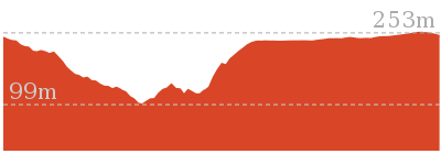
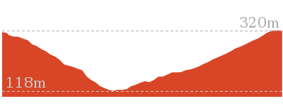
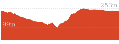
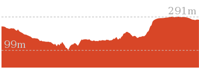
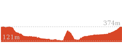
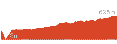
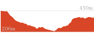
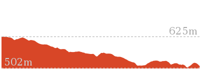
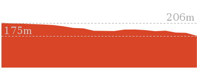
Cross sectional view of the Martins Lookout Loop Walk bushwalking track
Analysis and summary of the altitude variation on the Martins Lookout Loop Walk
Overview of this walks grade – based on the AS 2156.1 – 2001
Under this standard, a walk is graded based on the most difficult section of the walk.
| Length | 13.8 km | ||
| Time | 6 hrs 30 mins | ||
| . | |||
| Grade 4/6 Hard track |
AS 2156.1 | Gradient | Very steep (4/6) |
| Quality of track | Rough track, where fallen trees and other obstacles are likely (4/6) | ||
| Signs | Minimal directional signs (4/6) | ||
| Experience Required | No experience required (1/6) | ||
| Weather | Weather generally has little impact on safety (1/6) | ||
| Infrastructure | Limited facilities (such as cliffs not fenced, significant creeks not bridged) (4/6) |
Some more details of this walks Grading
Here is a bit more details explaining grading looking at sections of the walk
Gradient
6km of this walk is very steep and another 6km has short steep hills. Whilst another 1.5km is flat with no steps and the remaining 150m has gentle hills with occasional steps.
Quality of track
7km of this walk follows a rough track, where fallen trees and other obstacles are likely and another 4.8km follows a formed track, with some branches and other obstacles. The remaining (1.6km) follows a smooth and hardened path.
Signs
7km of this walk has directional signs at most intersection and another 4.8km has minimal directional signs. The remaining (1.7km) is clearly signposted.
Experience Required
This whole walk, 14km requires no previous bushwalking experience.
weather
This whole walk, 14km is not usually affected by severe weather events (that would unexpectedly impact safety and navigation).
Infrastructure
6km of this walk has limited facilities (such as cliffs not fenced, significant creeks not bridged) and another 5km has limited facilities (such as not all cliffs fenced). The remaining (2.1km) is close to useful facilities (such as fenced cliffs and seats).
Similar walks
A list of walks that share part of the track with the Martins Lookout Loop Walk walk.
180 m Return
15 mins
Moderate track
1.2 km Return
1 hr 30 mins
Hard track
2.7 km Return
1 hr 30 mins
Hard track
3.1 km Return
3 hrs 30 mins
Experienced only
5.4 km Return
3 hrs 30 mins
Experienced only
6.1 km One way
3 hrs
Hard track
9 km Return
4 hrs
Hard track
10.5 km Circuit
4 hrs 15 mins
Hard track
11.5 km One way
5 hrs
Hard track
13.5 km One way
6 hrs
Experienced only
15.2 km One way
2 Days
Experienced only
15.9 km One way
7 hrs
Experienced only
23.4 km One way
2 Days
Experienced only
Other Nearby walks
A list of walks that start near the Martins Lookout Loop Walk walk.
202 m Return
15 mins
Moderate track
3.5 km Return
2 hrs
Hard track
2.6 km Circuit
1 hr 30 mins
Hard track
2.9 km One way
2 hrs
Hard track
4.3 km Circuit
2 hrs 30 mins
Hard track
4 km Return
2 hrs
Hard track
6 km One way
3 hrs
Hard track
8.6 km Return
3 hrs 30 mins
Hard track
18.3 km One way
7 hrs 15 mins
Experienced only
29.6 km One way
3 Days
Hard track
1 km Return
30 mins
Moderate track
4.1 km Circuit
2 hrs
Moderate track
Plan your trip to and from the walk here
The Martins Lookout Loop Walk walk starts and ends at the Springwood Station (gps: -33.699107, 150.5638)
Your transport options to Springwood Station are by;
![]() Train. (get details)
Train. (get details)
![]() Bus. (get details)
Bus. (get details)
![]() Car. There is free parking available.
Car. There is free parking available.
(get details)
Short URL = http://wild.tl/mllw
Gallery images
There are other downloads I am still working on.
You will probably need to login to access these — still all free.
* KML (google earth file)
* GPX (GPS file)
Special Maps/ brochures
* A3 topo maps
* PDF with Lands Topo map base
* PDF with arial image (and map overlay)
I wanted to get the main site live first, this extra stuff will come in time.
Happy walking
Matt 🙂
Faulconbridge to Blaxland
And Walk
Faulconbridge to Blaxland

2 Days
15.2 km One way
693 m
Experienced only
This two-day walk, or very solid one-day walk, takes you from station to station, through lush, scenic forest in the lower Blue Mountains. The walk follows the upper section of Glenbrook Creek most of the way to Blaxland, with a venture over the St Helena Ridge to add some views. An enjoyable two-day walk exploring the diverse range of gully and rocky ridge-top environments in the lower Blue Mountains.* This walk passes through very remote areas and sections have no visible track. At least one person in your group should have training and experience in off track walking and navigation. Even with these notes and a GPS these extra skills and equipment are required.


Faulconbridge
Faulconbridge, in the Blue Mountains, New South Wales, was named after the maiden name of Sir Henry Parkes’ mother. Faulconbridge sits on the Great Western Highway and is surrounded by valleys of lush bushland. This picturesque town was a home, and final resting place, for Sir Henry Parkes’, heralded as the ‘Father of Federation’. Faulconbridge was originally explored by non-indigenous Australians in 1813, by Blaxland, Wentworth and Lawson who were searching for a route over the Blue Mountains .
(0km) Faulconbridge Station → No. 10 Sir Henrys Pde
410 m
8 mins
10m
-16m
Moderate track
From the top of Faulconbridge Station, the walk heads off the station overpass to the bushland side of the station (if you come to a car park, you have gone to the wrong side of the station). The walk then keeps the rail line on the left as it follows the footpath down to the road. After a while, the walk comes to an intersection with Sir Henrys Pde, opposite house number 10.
Victory Track

The Victory Track is more formally know as the ‘Sir Henry Parkes Victory Track’[4] and is called the ‘Victoria Track’ in many guide books. The track starts near Sir Henry Parkes’ grave in Faulconbridge and leads to Sassafrass Gully Creek. Sir Henry Parks (1815-1896) was a politician and journalist, born in England. He is considered to be the ‘Father of Federation’ for Australia, although he died of natural causes 5 years before Australia’s federation. Parkes was the premier of New South Wales five times. The town Parkes was named in his honour. Parkes would sometime write under the pseudonym ‘Faulconbridge’ (his mothers maiden name) for the Sydney Morning Herald and other papers and Faulconbridge (the township) was named after his mother when Parkes purchased 600 acres in 1877. More info.
(0.41km) No. 10 Sir Henrys Pde → Int. Victory Trk and Clarinda Falls
1.3 km
38 mins
15m
-173m
Hard track
Turn right: From 10 Sir Henrys Pde (bushland side), the walk follows the ‘Victory Track’ sign down into the bush. The walk passes under a few rock overhangs and then crosses a creek. Passing a smaller track (on the left, which leads to the top of the falls), the walk soon comes down to a ‘Clarinda Falls’ sign[10].
(1.74km) Int. Victory Trk and Clarinda Falls → Clarinda Falls
30 m
1 mins
1m
-4m
Moderate track
Turn left: From the intersection, the track follows the ‘Clarinda Falls’ sign[11] towards the log fallen on the rock. The track tends left around the hillside, coming to Clarinda Falls. At the end of this side trip, retrace your steps back to the main walk then Continue straight.
Clarinda Falls

Clarinda Falls is a charming waterfall on Sassafras Creek. The water cascades over a near-vertical wall, into a sandy pool below. The falls are signposted from the main track and provide a nice cool detour, especially on warmer days. The falls are named for the first wife of Sir Henry Parkes, ‘Father of Australian Federation’.
(1.74km) Int. Victory Trk and Clarinda Falls → Victory Trk camping area
630 m
18 mins
23m
-72m
Hard track
Turn right: From the intersection, the walk follows the ‘Sassafras Gully’ sign[13] down the hill. The track keeps the creek on the left as it continues down the gully then crosses a creek junction. The walk meanders down the hillside and soon crosses a larger creek junction, before entering a campground clearing (beneath power lines).
Victory Track camping area
Victory Track camping area is a fairly large, informal camping place at the junction of Sassafras and Numantia Creeks. The clearing is in a moist section of forest with plenty of shade. Water from the creek should be treated before use.
(2.37km) Victory Trk camping area → Victory Trk pool
880 m
24 mins
61m
-78m
Moderate track
Continue straight: From the campground clearing, the walk follows the creek, keeping it to the left. The track winds up the hill and back down to the creek a few times and soon comes to an intersection with a faint track on the left (which leads to a pool in the creek).
Victory Track pool
The Victory Track pool is an unofficially-named pond in Sassafras Creek. The pond is deep in parts but not adequate for a swim. It does, however, offer a chance to rest and gaze over the water. There is a small sandy beach, some moss-covered rocks and a lovely grove of Sassafras trees around the pool. This is a nice spot to stop, catch your breath and soak up your surroundings.
(3.24km) Victory Trk pool → Perch Ponds camping area
3.4 km
1 hr 11 mins
85m
-165m
Hard track
Continue straight: From the intersection, the walk heads down the valley, keeping the creek on the left. The walk soon turns left, crosses the creek and continues down the valley, with the creek now on the right. Leading down the valley, the track then crosses a gully to arrive at a blue ‘Faulconbridge Station’ sign (pointing back the way you came)[14].
Turn right: From the intersection, the walk heads down across the creek in the direction of the ‘To Wiggins Track’ sign[15]. The walk winds along the hillside, keeping the creek on the right, passing a blue track marker[16] which directs the walk to the other side of the creek. The walk now keeps the creek on the left as it winds up to a ‘Perch Ponds, Springwood Stn’ sign[17].
Veer right: From the intersection, the walk follows the direction of the ‘Perch Ponds’ sign[18] across the hillside. The walk soon nears the creek on the left, then undulates above it for a short while. The track crosses a steeply banked creek junction, then continues following the main creek (which is on the left). The walk stays near this creek, coming into a campground clearing with large boulders.
Continue straight: From the campground clearing, the walk exits the clearing, keeping the main creek to the right, and immediately crosses a side creek. The walk keeps the main creek on the right as it slowly climbs the hillside. The track then heads downhill, passing under a few rock overhangs and soon entering the campground clearing of ‘Perch Ponds’.
Perch Ponds Campsite
Perch Ponds is a lovely waterhole, with a clearing suitable to pitch a tent, located at the junction of Magdala Creek and Glenbrook Creeks. The meeting of the two creek provides a relaxing sound of rushing water and a cool spot to rest on warmer days. The campsite is a flat area above the pool marked with a fire scar. A great shady and quiet area for a camp. There are no facilities and water from the creek needs to be treated.
(6.62km) Perch Ponds camping area → Martins camping area
1.2 km
27 mins
51m
-67m
Hard track
Continue straight: From the intersection, the walk follows the direction of the ‘Martins Lookout’ sign across the campground clearing to an arrow bolted to a tree. The walk follows this arrow down the hill and across the creek, and then follows creek, keeping it on the right. The walk leads up the hill away from the creek to a signposted intersection for ‘Martins Lookout’.
Veer right: From the intersection, the walk follows direction of the ‘Long Track’ sign, down the hill. The track winds down near the creek and passes a sandy beach access before soon entering a second clearing.
Veer right: From the intersection, the walk follows direction of the ‘Long Track’ sign, down the hill. The track winds down near the creek and passes a sandy beach access before soon entering a second clearing.
Martins campsite
Martins campsite is an unofficial camping area beside Glenbrook Creek. The camping area is a sandy clearing, opposite cliffs on the other bank. The camping area is situated below Martins Lookout, with Bunyan Lookout up the ridge on the opposite hillside. A quiet and shaded location which can give a great night’s sleep.
End of day 1
This is the planned overnight stay for the end of day 1, happy camping.
(7.79km) Martins camping area → Bunyan Lookout
1.2 km
44 mins
235m
-39m
Experienced only
Turn left: From the fireplace, the walk heads along the creek bank, keeping the creek near and on the right. The walk then tends left, up the hill to the intersection and pole without a sign.
Veer right: From the intersection, the walk follows the ‘Bunyan Lkt’ post down the stairs. The walk soon meets the creek and turns left, following the creek for a short distance before crossing at an opening in the shrubs around the creek. From here, the walk follows the cairns (rock stacks) across creek flats before climbing the hill to the base of a small cliff line. At one point beneath the cliff line, the walk ducks through a hole in the rock, then winds up through boulders, following more cairns. The walk continues up the hill, passing through a few more rocky outcrops to reach the informal, unfenced Bunyan Lookout, in a clearing near the cliff line.
Veer right: From the intersection, the walk follows the ‘Bunyan Lkt’ post down the stairs. The walk soon meets the creek and turns left, following the creek for a short distance before crossing at an opening in the shrubs around the creek. From here, the walk follows the cairns (rock stacks) across creek flats before climbing the hill to the base of a small cliff line. At one point beneath the cliff line, the walk ducks through a hole in the rock, then winds up through boulders, following more cairns. The walk continues up the hill, passing through a few more rocky outcrops to reach the informal, unfenced Bunyan Lookout, in a clearing near the cliff line.
Bunyan Lookout
Bunyan Lookout is an large, unfenced sandstone platform overlooking the Glenbrook Creek valley. Behind the lookout, there is a small sandy clearing, big enough for a few tents. The lookout spans across Glenbrook Creek and sandstone cliffs of the valley.
(8.98km) Bunyan Lookout → Int. Bunyan Lookout Trk and Lost Worlds Trk
570 m
10 mins
18m
-7m
Moderate track
Turn sharp right: From Bunyan Lookout, the walk heads back into the clearing behind the unfenced cliff line and turns left at the cairn (if you head down into the valley, you have gone the wrong way). The walk meanders through the heath for a short time before coming to a red painted stump, on the right of the track.
(9.55km) Int. Bunyan Lookout Trk and Lost Worlds Trk → Lost Worlds Lookout
570 m
11 mins
20m
-13m
Moderate track
Turn right: From the red stump intersection, the walk follows the ‘Lost Worlds’ sign up the small hill. The walk winds through the bush for a short time then crosses a rocky surface. The track then leaves the rocky surface briefly to return to a similar rock surface with a white crucifix on the edge of the cliff. At the end of this side trip, retrace your steps back to the main walk then Turn right.
Lost Worlds Lookout
Lost Worlds Lookout is a cliff edge marked by a cross. The cross commemorates the Rev. Raymer who was a prominent bushwalker in the area, and has been commemorated by a plaque at Martins Lookout across the valley. The lookout views Glenbrook Creek valley below, the surrounding cliffs and down to Penrith in the west.
(9.55km) Int. Bunyan Lookout Trk and Lost Worlds Trk → St Helena Ridge Lookout
3.4 km
59 mins
13m
-132m
Hard track
Continue straight: From the intersection, the walk heads in a southerly direction away from the red stump, keeping it behind on the right of the track. The walk winds through the bush, crossing a few sandy areas that lead to a small cairn marking the intersection, on the left of the track.
Veer left: From the intersection, this walk heads south east along track soon leading downhill. The walk meanders through the heath for quite some time. The walk nears a cliff line on the left, which it continues near for a short time before opening out onto a rocky outcrop with a view across to houses on the opposite hill (just before the steep downhill section).
Veer left: From the intersection, this walk heads south east along track soon leading downhill. The walk meanders through the heath for quite some time. The walk nears a cliff line on the left, which it continues near for a short time before opening out onto a rocky outcrop with a view across to houses on the opposite hill (just before the steep downhill section).
St Helena Ridge Lookout
St Helena Ridge Lookout, does not have the clearest view or the most spectacular scenery. However, it is a great place to rest before continuing on your way.
(12.94km) St Helena Ridge Lookout → Int. Waterfall and ridge trk
360 m
18 mins
4m
-122m
Experienced only
Continue straight: From St Helena Ridge lookout, the walk follows a very faint track initially very steeply down off the rock platform, The track initially tends a little to the left to then follow the main ridge line down. The track soon becomes much less steep (and a little clearer) when after about 100m the faint track bends right at another rocky outcrop. Here the walk leads off the side of the ridge to then wind down through the rocky outcrops and continue down through the scrub for about 180m until just before Glenbrook Creek where this walk comes to an un-signposted intersection.
(13.3km) Int. Waterfall and ridge trk → St Helena waterfall
160 m
3 mins
4m
-6m
Experienced only
Veer left: From the intersection, the walk heads upstream, keeping the creek on the right. The track undulates along the bank, passing a few large boulders in the creek before coming to a sandy beach at a bend in the creek.
Continue straight: From the beach, the walk heads across the sand bar (covered in reeds) to come within ear-shot of the waterfall, located behind the inlet on the creek. The walk passes through the sandy, shallow section of the creek then walks up the bank and around to the waterfall. At the end of this side trip, retrace your steps back to the main walk then Continue straight.
Continue straight: From the beach, the walk heads across the sand bar (covered in reeds) to come within ear-shot of the waterfall, located behind the inlet on the creek. The walk passes through the sandy, shallow section of the creek then walks up the bank and around to the waterfall. At the end of this side trip, retrace your steps back to the main walk then Continue straight.
St Helenas waterfall
St Helenas waterfall is a small fall, flowing from a side creek into Glenbrook Creek. It is rather unimpressive unless there has been recent rainfall. The water cascades down a nice rock face, among the sassafras trees and mossy rocks.
(13.3km) Int. Waterfall and ridge trk → Blaxland Library Carpark
1.4 km
34 mins
150m
-28m
Experienced only
Turn right: From the intersection, the walk heads downstream, keeping the creek on the left. After approximately 10m, the walk comes to a bushy creek crossing and winds over the rocks and through the bushes. Following this, the walk keeps the creek on the right whilst winding downstream. The track soon arrives at an intersection, which is a sandy area with rocks and stairs leading up the hill.
Turn left : From the large boulder, this walk heads up the hill and climbs the stone steps steeply, with a number of pink ribbons marking the initial track. The track continues steeply (eroded in places) up the hill and winds its way up to the un-signposted T-intersection.
Turn sharp right: From the intersection[19], this walk heads along the mostly flat track along the side of the hill, keeping the valley to your right. Soon the track leads to another intersection at the base of more stone steps, and a rock wall (on the left) that has ‘Florabella Pass’ engraved in it[20].
Continue straight: From the intersection, the walk heads around the boulder (which is on the left) and soon meets a set of stairs, to the left of a ‘Pippas Pass’ sign[21] in a tree.
Turn right: From the intersection[22], this walk follows the ‘Pippas Pass’ sign[23] (that is about 2m up a tree) gently downhill along the track, directly away from the rockface, keeping the main valley to your right. The track winds along the side of the hill for about 100m
to then climb up a set of sandstone steps just past a shallow sandstone overhang[24]. From here the track gently undulates along the side of the hill (with a steep valley to your right[25]) for about 300m to lead gently down and cross the usually small creek in the shaded valley[26]. Just after crossing this creek[27], the track bends left to head gently up through the valley along the base of a few natural sandstone walls[28] for about 200m, where the the track becomes rocky and starts to climb a bit more steeply. The track then leads up through a cleft in the rock[29] then about 60m later comes to a unsignposted three-way intersection (with the track on the left crossing the creek), marked with a smooth bark Angophera[30].
Turn left: From the intersection[31], this walk crosses the sandstone platform and creek[32]. Here the track winds gently uphill for about 40m to cross a smaller often dry creek [33] where the track continues uphill for another 30m to pass a grafittied sandstone overhang (on your left)[34]. The track continues gently uphill and bends right to cross a sandstone rock platform and small creek[35] to almost immediately come to a faint intersection with a track in the tall heath[36]. Here the walk turns left and heads uphill for for about 50m where the track then leads up some steps to come to the base of a sandstone cliff and smaller overhang[37]. Here the track bends left and and continues along the side of the hill for another 15m to pass a larger and more grafittied sandstone overhang[38]. From here the track continues to wind more steeply uphill for about 80m before turning left and following a wider track (away from the houses) and into the lower car park of Blaxland library just past the ‘Bushcare site’ information sign[39]. Here this walk turns right to head up to the library and main car park[40].
(14.69km) Blaxland Library Carpark → Blaxland shops
460 m
9 mins
28m
-9m
Very easy
Turn left: From the Blaxland Library car park[41], this walk heads up the ramp on the side of the building[42] then follows the back deck behind the library and community centre[43]. On the far side of the building, this walk follows the bitumen footpath[44] footpath uphill to turn left at the ‘Blaxland Civic Centre’[45] sign onto the footpath beside Hope St. This walk follows the footpath uphill for about 150m before turning right to cross Hope St at the traffic calming device[46]. Here the walk bends left and crosses a car park entrance[47], then soon turns right into ‘Station St’[48]. Here the walk heads up the footpath to cross another car park entrance[49] then onto the pedestrian lane way that leads between the buildings, under the foot bridge[50] to the main footpath, just before the Great Western Highway, among the Blaxland shops.
Blaxland
Blaxland, found along the Great Western Highway, is one of the larger towns of the Lower Blue Mountains. The town has a number of shops and petrol station all lining the highway which lies between the town and train station. Wascoe was the original name of Blaxland until 1914 when it was renamed after Gregory Blaxland who was one of the explorers who found the route across the mountains for the colony . The Blaxland community hosts a number of events during the month of September. More info.
(15.15km) Blaxland Shops → Blaxland Station
70 m
1 mins
0m
0m
Very easy
Turn left: From the footpath, the walk uses the stairs or ramp to climb onto the pedestrian bridge. The walk then crosses the bridge over the Great Western Highway and then heads down onto Blaxland Station.
Maps for the Faulconbridge to Blaxland walk
You can download the PDF for this walk to print a map.
These maps below cover the walk and the wider area around the walk, they are worth carrying for safety reasons.
| Springwood | 1:25 000 Map Series | 90304S SPRINGWOOD | NSW-90304S |
| Penrith | 1:25 000 Map Series | 90303N PENRITH | NSW-90303N |
| Penrith | 1:100 000 Map Series | 9030 PENRITH | 9030 |
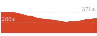
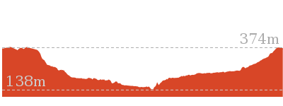
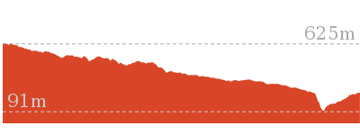
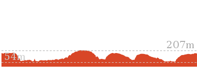
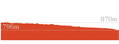
Cross sectional view of the Faulconbridge to Blaxland bushwalking track
Analysis and summary of the altitude variation on the Faulconbridge to Blaxland
Daily actual walking time estimates
| Day | Walking Time | Length |
|---|---|---|
| 1 | 3 hrs 7 mins | 7.8 km |
| 2 | 3 hrs 9 mins | 8.2 km |
Overview of this walks grade – based on the AS 2156.1 – 2001
Under this standard, a walk is graded based on the most difficult section of the walk.
| Length | 15.2 km | ||
| Time | 2 Days | ||
| . | |||
| Grade 5/6 Experienced only |
AS 2156.1 | Gradient | Very steep (4/6) |
| Quality of track | Rough unclear track (5/6) | ||
| Signs | No directional signs (5/6) | ||
| Experience Required | Moderate level of bushwalking experience recommended (4/6) | ||
| Weather | Storms may impact on navigation and safety (3/6) | ||
| Infrastructure | No facilities provided (5/6) |
Some more details of this walks Grading
Here is a bit more details explaining grading looking at sections of the walk
Gradient
6km of this walk has short steep hills and another 4.3km is very steep. Whilst another 4.1km has gentle hills with occasional steps and the remaining 530m is flat with no steps.
Quality of track
7km of this walk follows a rough track, where fallen trees and other obstacles are likely and another 6km follows a formed track, with some branches and other obstacles. Whilst another 1.4km follows a rough unclear track and a 940m section follows a smooth and hardened path. The remaining 55m follows a clear and well formed track or trail.
Signs
6km of this walk has directional signs at most intersection and another 6km has minimal directional signs. Whilst another 2.3km is clearly signposted and the remaining 1.1km Has no directional signs.
Experience Required
14km of this walk requires no previous bushwalking experience and another 1.3km requires some bushwalking experience. The remaining (110m) requires a leader a with moderate level of bushwalking experience.
weather
Around 14km of this walk is not usually affected by severe weather events (that would unexpectedly impact safety and navigation), whilst the remaining 1.3km is affected by storms that may impact your navigation and safety.
Infrastructure
8km of this walk has limited facilities (such as cliffs not fenced, significant creeks not bridged) and another 4.9km has limited facilities (such as not all cliffs fenced). Whilst another 2.3km is close to useful facilities (such as fenced cliffs and seats) and the remaining 100m has no facilities provided.
Similar walks
A list of walks that share part of the track with the Faulconbridge to Blaxland walk.
2.6 km Circuit
1 hr 30 mins
Hard track
2.9 km One way
2 hrs
Hard track
3.1 km Return
3 hrs 30 mins
Experienced only
3.5 km Return
2 hrs
Hard track
4 km Return
2 hrs
Hard track
4.3 km Circuit
2 hrs 30 mins
Hard track
5.4 km Return
3 hrs 30 mins
Experienced only
6 km One way
3 hrs
Hard track
6.1 km One way
3 hrs
Hard track
10.5 km Circuit
4 hrs 15 mins
Hard track
11.5 km One way
5 hrs
Hard track
13.5 km One way
6 hrs
Experienced only
13.8 km Circuit
6 hrs 30 mins
Hard track
15.9 km One way
7 hrs
Experienced only
18.3 km One way
7 hrs 15 mins
Experienced only
23.4 km One way
2 Days
Experienced only
Other Nearby walks
A list of walks that start near the Faulconbridge to Blaxland walk.
2.7 km Return
1 hr 30 mins
Hard track
9 km Return
4 hrs
Hard track
202 m Return
15 mins
Moderate track
180 m Return
15 mins
Moderate track
1.2 km Return
1 hr 30 mins
Hard track
8.6 km Return
3 hrs 30 mins
Hard track
29.6 km One way
3 Days
Hard track
8.6 km Circuit
5 hrs
Hard track
5.6 km Return
2 hrs
Moderate track
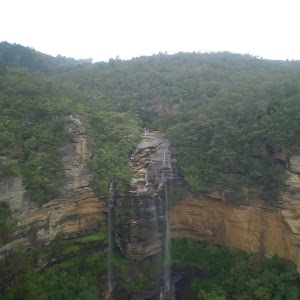
9.4 km Circuit
4 hrs
Moderate track
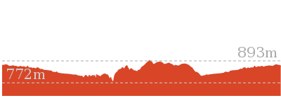
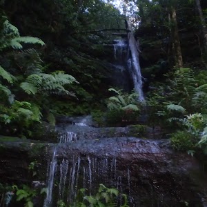
6.7 km Circuit
3 hrs
Hard track
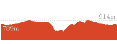
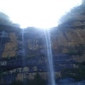
10.2 km Circuit
6 hrs
Hard track
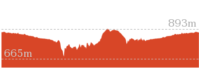
Plan your trip to and from the walk here
The Faulconbridge to Blaxland walk starts at the Faulconbridge Station (gps: -33.69662, 150.53487)
Your transport options to Faulconbridge Station are by;
![]() Train. (get details)
Train. (get details)
![]() Bus. (get details)
Bus. (get details)
![]() Car. There is free parking available.
Car. There is free parking available.
(get details)
The Faulconbridge to Blaxland ends at the Blaxland Station (gps: -33.743785, 150.60987)
Your transport options to Blaxland Station are by;
![]() Train. (get details)
Train. (get details)
![]() Bus. (get details)
Bus. (get details)
![]() Car. There is free parking available.
Car. There is free parking available.
(get details)
Short URL = http://wild.tl/ftb
Gallery images
There are other downloads I am still working on.
You will probably need to login to access these — still all free.
* KML (google earth file)
* GPX (GPS file)
Special Maps/ brochures
* A3 topo maps
* PDF with Lands Topo map base
* PDF with arial image (and map overlay)
I wanted to get the main site live first, this extra stuff will come in time.
Happy walking
Matt 🙂
Woodford to Blaxland Station
And Walk
Woodford to Blaxland Station

7 hrs 15 mins
18.3 km One way
519 m
Experienced only
This walk takes a scenic route across the ridges and down to Glenbrook Creek before climbing to Blaxland. The walk is dotted with many views and usually much wildlife along the way. If there has been substantial rain, the side trip to St Helena waterfall is worth checking out.* This walk passes through very remote areas and sections have no visible track. At least one person in your group should have training and experience in off track walking and navigation. Even with these notes and a GPS these extra skills and equipment are required.
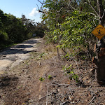
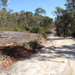


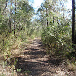

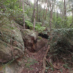
Woodford
Woodford is situated along the Great Western Highway in the Blue Mountains. Woodford boasts one of the Blue Mountains oldest buildings, with the Woodford Academy dating back to 1833 . Access to the academy is made easy by Woodford train station and other public transport connections. Woodford is also the start of the popular Woodford to Glenbrook mountain bike which follows the Oaks Fire trail. Woodford station offers a public telephone and toilets. There are no commercial facilities in the area.
(0km) Woodford Station → Int. Oaks Firetrail and Old Bathurst Rd
730 m
15 mins
22m
-39m
Easy track
From the station, this walk heads down the stairs, off the station and turns left under the station. It then continues up to Railway Parade, opposite a shelter with a bench seat. The walk heads up Railway Pde, keeping the railway tracks to the left. The road tends right then the walk turns right onto The Appian Way. The walk follows The Appian Way, which turns into Parker St. (If you cross over a bridge, you have gone the wrong way.) The walk leads along Parker St to Taylor St, where it turns left and continues down the hill to the intersection with The Oaks Fire Trail. This is signposted at the clearing on the right.
(0.73km) Int. Oaks Firetrail and Old Bathurst Rd → Int. Oaks Firetrail and cliff lookout Trk
3.5 km
1 hr 10 mins
87m
-175m
Moderate track
Turn right: From the road, the walk heads to the gate and crosses over it. (On the lower side of the gate is a tap which provides drinking water.) From the gate and tap, the walk heads down the hill, passing a broken interpretative sign on the left, and continues to wind and undulate for quite some time. The trail passes a mound in a junction. From the mound, the trail continues to wind and undulate, turning right and steeply downhill twice, before passing a small dam (just to the left). The walk winds, with the hillside higher on the right than left, before leading up a steep slope to a small clearing with a large step.
(4.21km) Int. Oaks Firetrail and cliff lookout Trk → Cliff lookout
100 m
3 mins
5m
-18m
Hard track
Turn right: From the intersection, the walk heads away from the management trail, with the small depression (or waterhole) on the left, surrounded by reeds. The track winds up the hill, following the gap in the vegetation, leading to a rock shelf with a view. At the end of this side trip, retrace your steps back to the main walk then Turn right.
Cliff Lookout
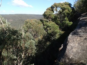
Cliff lookout, an unofficially-named, informal view point, is a dramatic cliff edge perched just above the trees. The cliff is unfenced. The view across the valley provides a pleasant panorama.
(4.21km) Int. Oaks Firetrail and cliff lookout Trk → Int. St Helena Ridge Trail and Bunyah Lookout Trk
6.9 km
2 hrs 21 mins
187m
-363m
Hard track
Continue straight: From the intersection, the walk heads down the hill in a southerly direction and tends right. At the bottom of the hill, the trail winds left and then up a hill to the right, onto a plateau with clearer, lower vegetation. The management trail here is also lined by large rocks, which look as though they could have been placed there. The trail comes off the hill and heads across a saddle to a large management trail intersection (on the left).
Turn left : From the intersection, the walk heads east, down the rocky management trail. The trail winds down the hill, passing over sandy and rocky areas. The trail then flattens out, undulating and winding for quite some time, with the track widening and narrowing greatly in many areas. After some time, the walk enters a large clearing, with a rocky outcrop to the right.
Turn left : From the intersection, the walk heads east, down the rocky management trail. The trail winds down the hill, passing over sandy and rocky areas. The trail then flattens out, undulating and winding for quite some time, with the track widening and narrowing greatly in many areas. After some time, the walk enters a large clearing, with a rocky outcrop to the right.
(11.1km) Int. St Helena Ridge Trail and Bunyan Lookout Trk → St Helena Ridge Lookout
4.9 km
1 hr 26 mins
41m
-174m
Hard track
Turn left : From the intersection, the walk heads north-east out of the small clearing. The track winds through the heath for a short time before coming to a clearing with a fireplace, on the left.
Continue straight: From the intersection, the walk heads north-east along the sandy track. The walk meanders through low, green heath for quite some time, winding through a section of pines before returning to heath as the track arrives at the cairn, on the right, which marks the intersection.
Turn sharp right: From the intersection, this walk heads south east along track soon leading downhill. The walk meanders through the heath for quite some time. The walk nears a cliff line on the left, which it continues near for a short time before opening out onto a rocky outcrop with a view across to houses on the opposite hill (just before the steep downhill section).
St Helena Ridge Lookout
St Helena Ridge Lookout, does not have the clearest view or the most spectacular scenery. However, it is a great place to rest before continuing on your way.
(16.03km) St Helena Ridge Lookout → Int. Waterfall and ridge trk
360 m
18 mins
4m
-122m
Experienced only
Continue straight: From St Helena Ridge lookout, the walk follows a very faint track initially very steeply down off the rock platform, The track initially tends a little to the left to then follow the main ridge line down. The track soon becomes much less steep (and a little clearer) when after about 100m the faint track bends right at another rocky outcrop. Here the walk leads off the side of the ridge to then wind down through the rocky outcrops and continue down through the scrub for about 180m until just before Glenbrook Creek where this walk comes to an un-signposted intersection.
(16.38km) Int. Waterfall and ridge trk → St Helena waterfall
160 m
3 mins
4m
-6m
Experienced only
Veer left: From the intersection, the walk heads upstream, keeping the creek on the right. The track undulates along the bank, passing a few large boulders in the creek before coming to a sandy beach at a bend in the creek.
Continue straight: From the beach, the walk heads across the sand bar (covered in reeds) to come within ear-shot of the waterfall, located behind the inlet on the creek. The walk passes through the sandy, shallow section of the creek then walks up the bank and around to the waterfall. At the end of this side trip, retrace your steps back to the main walk then Continue straight.
Continue straight: From the beach, the walk heads across the sand bar (covered in reeds) to come within ear-shot of the waterfall, located behind the inlet on the creek. The walk passes through the sandy, shallow section of the creek then walks up the bank and around to the waterfall. At the end of this side trip, retrace your steps back to the main walk then Continue straight.
St Helenas waterfall
St Helenas waterfall is a small fall, flowing from a side creek into Glenbrook Creek. It is rather unimpressive unless there has been recent rainfall. The water cascades down a nice rock face, among the sassafras trees and mossy rocks.
(16.38km) Int. Waterfall and ridge trk → Blaxland Library Carpark
1.4 km
34 mins
150m
-28m
Experienced only
Turn right: From the intersection, the walk heads downstream, keeping the creek on the left. After approximately 10m, the walk comes to a bushy creek crossing and winds over the rocks and through the bushes. Following this, the walk keeps the creek on the right whilst winding downstream. The track soon arrives at an intersection, which is a sandy area with rocks and stairs leading up the hill.
Turn left : From the large boulder, this walk heads up the hill and climbs the stone steps steeply, with a number of pink ribbons marking the initial track. The track continues steeply (eroded in places) up the hill and winds its way up to the un-signposted T-intersection.
Turn sharp right: From the intersection[2], this walk heads along the mostly flat track along the side of the hill, keeping the valley to your right. Soon the track leads to another intersection at the base of more stone steps, and a rock wall (on the left) that has ‘Florabella Pass’ engraved in it[3].
Continue straight: From the intersection, the walk heads around the boulder (which is on the left) and soon meets a set of stairs, to the left of a ‘Pippas Pass’ sign[4] in a tree.
Turn right: From the intersection[5], this walk follows the ‘Pippas Pass’ sign[6] (that is about 2m up a tree) gently downhill along the track, directly away from the rockface, keeping the main valley to your right. The track winds along the side of the hill for about 100m
to then climb up a set of sandstone steps just past a shallow sandstone overhang[7]. From here the track gently undulates along the side of the hill (with a steep valley to your right[8]) for about 300m to lead gently down and cross the usually small creek in the shaded valley[9]. Just after crossing this creek[10], the track bends left to head gently up through the valley along the base of a few natural sandstone walls[11] for about 200m, where the the track becomes rocky and starts to climb a bit more steeply. The track then leads up through a cleft in the rock[12] then about 60m later comes to a unsignposted three-way intersection (with the track on the left crossing the creek), marked with a smooth bark Angophera[13].
Turn left: From the intersection[14], this walk crosses the sandstone platform and creek[15]. Here the track winds gently uphill for about 40m to cross a smaller often dry creek [16] where the track continues uphill for another 30m to pass a grafittied sandstone overhang (on your left)[17]. The track continues gently uphill and bends right to cross a sandstone rock platform and small creek[18] to almost immediately come to a faint intersection with a track in the tall heath[19]. Here the walk turns left and heads uphill for for about 50m where the track then leads up some steps to come to the base of a sandstone cliff and smaller overhang[20]. Here the track bends left and and continues along the side of the hill for another 15m to pass a larger and more grafittied sandstone overhang[21]. From here the track continues to wind more steeply uphill for about 80m before turning left and following a wider track (away from the houses) and into the lower car park of Blaxland library just past the ‘Bushcare site’ information sign[22]. Here this walk turns right to head up to the library and main car park[23].
(17.78km) Blaxland Library Carpark → Blaxland shops
460 m
9 mins
28m
-9m
Very easy
Turn left: From the Blaxland Library car park[24], this walk heads up the ramp on the side of the building[25] then follows the back deck behind the library and community centre[26]. On the far side of the building, this walk follows the bitumen footpath[27] footpath uphill to turn left at the ‘Blaxland Civic Centre’[28] sign onto the footpath beside Hope St. This walk follows the footpath uphill for about 150m before turning right to cross Hope St at the traffic calming device[29]. Here the walk bends left and crosses a car park entrance[30], then soon turns right into ‘Station St’[31]. Here the walk heads up the footpath to cross another car park entrance[32] then onto the pedestrian lane way that leads between the buildings, under the foot bridge[33] to the main footpath, just before the Great Western Highway, among the Blaxland shops.
Blaxland
Blaxland, found along the Great Western Highway, is one of the larger towns of the Lower Blue Mountains. The town has a number of shops and petrol station all lining the highway which lies between the town and train station. Wascoe was the original name of Blaxland until 1914 when it was renamed after Gregory Blaxland who was one of the explorers who found the route across the mountains for the colony . The Blaxland community hosts a number of events during the month of September. More info.
(18.24km) Blaxland Shops → Blaxland Station
70 m
1 mins
0m
0m
Very easy
Turn left: From the footpath, the walk uses the stairs or ramp to climb onto the pedestrian bridge. The walk then crosses the bridge over the Great Western Highway and then heads down onto Blaxland Station.
Maps for the Woodford to Blaxland Station walk
You can download the PDF for this walk to print a map.
These maps below cover the walk and the wider area around the walk, they are worth carrying for safety reasons.
| Springwood | 1:25 000 Map Series | 90304S SPRINGWOOD | NSW-90304S |
| Penrith | 1:25 000 Map Series | 90303N PENRITH | NSW-90303N |
| Jamison | 1:25 000 Map Series | 89302N JAMISON | NSW-89302N |
| Katoomba | 1:25 000 Map Series | 89301S KATOOMBA | NSW-89301S |
| Penrith | 1:100 000 Map Series | 9030 PENRITH | 9030 |
| Katoomba | 1:100 000 Map Series | 8930 KATOOMBA | 8930 |
Cross sectional view of the Woodford to Blaxland Station bushwalking track
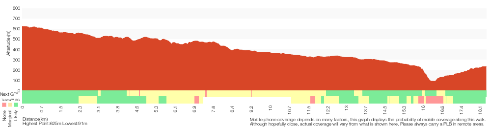
Analysis and summary of the altitude variation on the Woodford to Blaxland Station

Overview of this walks grade – based on the AS 2156.1 – 2001
Under this standard, a walk is graded based on the most difficult section of the walk.
| Length | 18.3 km | ||
| Time | 7 hrs 15 mins | ||
| . | |||
| Grade 5/6 Experienced only |
AS 2156.1 | Gradient | Very steep (4/6) |
| Quality of track | Rough unclear track (5/6) | ||
| Signs | No directional signs (5/6) | ||
| Experience Required | Moderate level of bushwalking experience recommended (4/6) | ||
| Weather | Storms may impact on navigation and safety (3/6) | ||
| Infrastructure | No facilities provided (5/6) |
Some more details of this walks Grading
Here is a bit more details explaining grading looking at sections of the walk
Gradient
11km of this walk has short steep hills and another 4.7km has gentle hills with occasional steps. Whilst another 1.6km is flat with no steps and the remaining 470m is very steep.
Quality of track
11km of this walk follows a rough track, where fallen trees and other obstacles are likely and another 6km follows a formed track, with some branches and other obstacles. Whilst another 1.3km follows a smooth and hardened path and a 450m section follows a rough unclear track. The remaining 55m follows a clear and well formed track or trail.
Signs
11km of this walk has minimal directional signs and another 6km has directional signs at most intersection. Whilst another 1.3km is clearly signposted and the remaining 100m Has no directional signs.
Experience Required
17km of this walk requires no previous bushwalking experience and another 1.3km requires some bushwalking experience. The remaining (110m) requires a leader a with moderate level of bushwalking experience.
weather
Around 17km of this walk is not usually affected by severe weather events (that would unexpectedly impact safety and navigation), whilst the remaining 1.3km is affected by storms that may impact your navigation and safety.
Infrastructure
11km of this walk has limited facilities (such as cliffs not fenced, significant creeks not bridged) and another 6km has limited facilities (such as not all cliffs fenced). Whilst another 1.3km is close to useful facilities (such as fenced cliffs and seats) and the remaining 100m has no facilities provided.
Similar walks
A list of walks that share part of the track with the Woodford to Blaxland Station walk.
2.6 km Circuit
1 hr 30 mins
Hard track
2.9 km One way
2 hrs
Hard track
4 km Return
2 hrs
Hard track
4.3 km Circuit
2 hrs 30 mins
Hard track
6 km One way
3 hrs
Hard track
8.6 km Return
3 hrs 30 mins
Hard track
13.5 km One way
6 hrs
Experienced only
15.2 km One way
2 Days
Experienced only
15.9 km One way
7 hrs
Experienced only
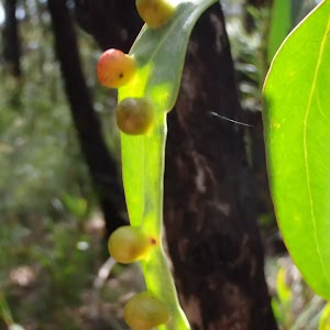
18.1 km One way
7 hrs
Hard track
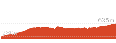
23.4 km One way
2 Days
Experienced only
29.6 km One way
3 Days
Hard track
Other Nearby walks
A list of walks that start near the Woodford to Blaxland Station walk.
180 m Return
15 mins
Moderate track
3.1 km Return
3 hrs 30 mins
Experienced only
1.2 km Return
1 hr 30 mins
Hard track
5.4 km Return
3 hrs 30 mins
Experienced only
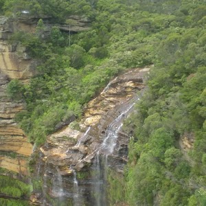
1.6 km One way
45 mins
Easy track
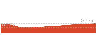
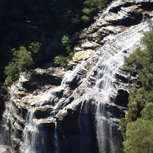
1.3 km Return
1 Hr
Moderate track
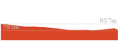
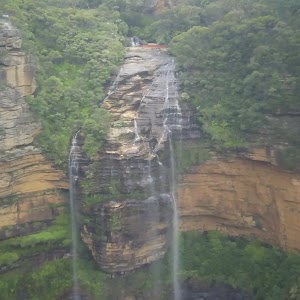
1.7 km Circuit
1 Hr
Hard track
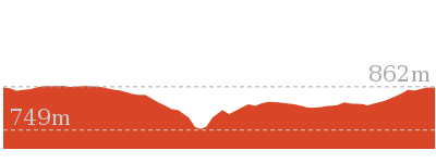

2.2 km Circuit
1 hr 30 mins
Hard track
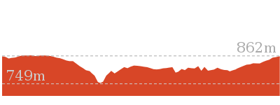
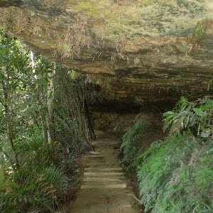
2 km Circuit
1 hr 30 mins
Moderate track
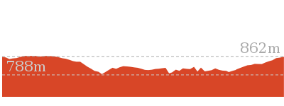
3.5 km Return
2 hrs
Hard track
6.1 km One way
3 hrs
Hard track
746 m Return
45 mins
Moderate track
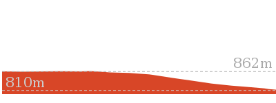
Plan your trip to and from the walk here
The Woodford to Blaxland Station walk starts at the Woodford Station (gps: -33.735763, 150.48228)
Your transport options to Woodford Station are by;
![]() Train. (get details)
Train. (get details)
![]() Bus. (get details)
Bus. (get details)
![]() Car. There is free parking available.
Car. There is free parking available.
(get details)
![]() Train. (get details)
Train. (get details)
The Woodford to Blaxland Station ends at the Blaxland Station (gps: -33.743785, 150.60987)
Your transport options to Blaxland Station are by;
![]() Bus. (get details)
Bus. (get details)
![]() Car. There is free parking available.
Car. There is free parking available.
(get details)
Short URL = http://wild.tl/wtbs
Gallery images
There are other downloads I am still working on.
You will probably need to login to access these — still all free.
* KML (google earth file)
* GPX (GPS file)
Special Maps/ brochures
* A3 topo maps
* PDF with Lands Topo map base
* PDF with arial image (and map overlay)
I wanted to get the main site live first, this extra stuff will come in time.
Happy walking
Matt 🙂
Woodford to Faulconbridge
And Walk
Woodford to Faulconbridge

2 Days
23.4 km One way
955 m
Experienced only
This walk starts out as mainly service trail to then drop into the Glenbrook Ck Valley for an overnight stay at Martins camping area. The next day the walk follows the winding bush track up the valley to Faulconbridge. In doing so the walk passes Clarinda Falls and some large pools which compliment the wonderful Glenbrook Creek.* This walk passes through very remote areas and sections have no visible track. At least one person in your group should have training and experience in off track walking and navigation. Even with these notes and a GPS these extra skills and equipment are required.


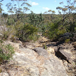
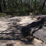
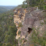
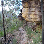
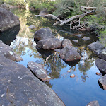
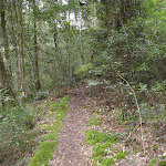

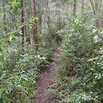
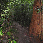
Woodford
Woodford is situated along the Great Western Highway in the Blue Mountains. Woodford boasts one of the Blue Mountains oldest buildings, with the Woodford Academy dating back to 1833 . Access to the academy is made easy by Woodford train station and other public transport connections. Woodford is also the start of the popular Woodford to Glenbrook mountain bike which follows the Oaks Fire trail. Woodford station offers a public telephone and toilets. There are no commercial facilities in the area.
(0km) Woodford Station → Int. Oaks Firetrail and Old Bathurst Rd
730 m
15 mins
22m
-39m
Easy track
From the station, this walk heads down the stairs, off the station and turns left under the station. It then continues up to Railway Parade, opposite a shelter with a bench seat. The walk heads up Railway Pde, keeping the railway tracks to the left. The road tends right then the walk turns right onto The Appian Way. The walk follows The Appian Way, which turns into Parker St. (If you cross over a bridge, you have gone the wrong way.) The walk leads along Parker St to Taylor St, where it turns left and continues down the hill to the intersection with The Oaks Fire Trail. This is signposted at the clearing on the right.
(0.73km) Int. Oaks Firetrail and Old Bathurst Rd → Int. Oaks Firetrail and cliff lookout Trk
3.5 km
1 hr 10 mins
87m
-175m
Moderate track
Turn right: From the road, the walk heads to the gate and crosses over it. (On the lower side of the gate is a tap which provides drinking water.) From the gate and tap, the walk heads down the hill, passing a broken interpretative sign on the left, and continues to wind and undulate for quite some time. The trail passes a mound in a junction. From the mound, the trail continues to wind and undulate, turning right and steeply downhill twice, before passing a small dam (just to the left). The walk winds, with the hillside higher on the right than left, before leading up a steep slope to a small clearing with a large step.
(4.21km) Int. Oaks Firetrail and cliff lookout Trk → Cliff lookout
100 m
3 mins
5m
-18m
Hard track
Turn right: From the intersection, the walk heads away from the management trail, with the small depression (or waterhole) on the left, surrounded by reeds. The track winds up the hill, following the gap in the vegetation, leading to a rock shelf with a view. At the end of this side trip, retrace your steps back to the main walk then Turn right.
Cliff Lookout
Cliff lookout, an unofficially-named, informal view point, is a dramatic cliff edge perched just above the trees. The cliff is unfenced. The view across the valley provides a pleasant panorama.
(4.21km) Int. Oaks Firetrail and cliff lookout Trk → Int. St Helena Ridge Trail and Bunyah Lookout Trk
6.9 km
2 hrs 21 mins
187m
-363m
Hard track
Continue straight: From the intersection, the walk heads down the hill in a southerly direction and tends right. At the bottom of the hill, the trail winds left and then up a hill to the right, onto a plateau with clearer, lower vegetation. The management trail here is also lined by large rocks, which look as though they could have been placed there. The trail comes off the hill and heads across a saddle to a large management trail intersection (on the left).
Turn left : From the intersection, the walk heads east, down the rocky management trail. The trail winds down the hill, passing over sandy and rocky areas. The trail then flattens out, undulating and winding for quite some time, with the track widening and narrowing greatly in many areas. After some time, the walk enters a large clearing, with a rocky outcrop to the right.
Turn left : From the intersection, the walk heads east, down the rocky management trail. The trail winds down the hill, passing over sandy and rocky areas. The trail then flattens out, undulating and winding for quite some time, with the track widening and narrowing greatly in many areas. After some time, the walk enters a large clearing, with a rocky outcrop to the right.
(11.1km) Int. St Helena Ridge Trail and Bunyan Lookout Trk → Int. Bunyan Lookout Trk and Lost Worlds Trk
2.7 km
47 mins
42m
-56m
Hard track
Turn left : From the intersection, the walk heads north-east out of the small clearing. The track winds through the heath for a short time before coming to a clearing with a fireplace, on the left.
Continue straight: From the intersection, the walk heads north-east along the sandy track. The walk meanders through low, green heath for quite some time, winding through a section of pines before returning to heath as the track arrives at the cairn, on the right, which marks the intersection.
Continue straight: From the intersection, the walk heads north, winding through the scrub. The walk meanders for a short time, passing through a few sandy sections before coming to a red painted stump in a clearer section of track.
(13.81km) Int. Bunyan Lookout Trk and Lost Worlds Trk → Lost Worlds Lookout
570 m
11 mins
20m
-13m
Moderate track
Turn left : From the red stump intersection, the walk follows the ‘Lost Worlds’ sign up the small hill. The walk winds through the bush for a short time then crosses a rocky surface. The track then leaves the rocky surface briefly to return to a similar rock surface with a white crucifix on the edge of the cliff. At the end of this side trip, retrace your steps back to the main walk then Turn left.
Lost Worlds Lookout
Lost Worlds Lookout is a cliff edge marked by a cross. The cross commemorates the Rev. Raymer who was a prominent bushwalker in the area, and has been commemorated by a plaque at Martins Lookout across the valley. The lookout views Glenbrook Creek valley below, the surrounding cliffs and down to Penrith in the west.
(13.81km) Int. Bunyan Lookout Trk and Lost Worlds Trk → Bunyan Lookout
570 m
10 mins
7m
-18m
Moderate track
Continue straight: From the intersection, the walk heads north-east, following the wider, more defined track. The track meanders little as it tends right but continues relatively straight along the spur, opening onto the clearing before the cliffs, overlooking Glenbrook Creek.
Bunyan Lookout
Bunyan Lookout is an large, unfenced sandstone platform overlooking the Glenbrook Creek valley. Behind the lookout, there is a small sandy clearing, big enough for a few tents. The lookout spans across Glenbrook Creek and sandstone cliffs of the valley.
(14.38km) Bunyan Lookout → Int. Martins Lookout and Bunyan Lookout Trk
960 m
38 mins
25m
-222m
Experienced only
Turn sharp left: From Bunyan Lookout, the walk heads away from the unfenced cliffs and through the clearing behind. At the end of the clearing, the walk turns right at a cairn (rock stack) and winds down the hill, steeply in sections, passing through a few rocky outcrops to a rock landing with a cairn, just in front of boulders. The walk follows the cairns between the boulders, then ducks through a hole in the rock and passes the small cliff line. The walk winds down the hill from the rocky outcrop, then follows the cairns across a flat area and crosses the creek. The track immediately turns left, following the creek for a short distance before turning right, up the stairs, and arriving at the intersection marked with a ‘Bunyan Lkt’ sign (pointing back the way you came).
(15.33km) Int. Martins Lookout and Bunyan Lookout Trk → Martins Lookout
530 m
26 mins
180m
-2m
Hard track
Turn right: From the intersection, the walk heads up the stairs and soon begins zigzagging up the hillside for a short time, coming to be under a cliff line. The track heads up stairs which head through the cliffs and winds steeply up to the next set of stairs. The track heads under many wonderful rock overhangs, as it winds its way using stairs to come up to Martins Lookout. At the end of this side trip, retrace your steps back to the main walk then Veer right.
Martins Lookout
Martin’s Lookout is an unfenced view on the rim of the plateau, south of Valley Heights. There are views across and up the Glenbrook Creek, and to the Lost Worlds lookout (on the opposite cliffs) which features a small white crucifix. This cross is in memory of Rev. Raymer who was an avid bushwalker in the area. The plaque in the rock at Martin’s Lookout is directly opposite this cross.
(15.33km) Int. Martins Lookout and Bunyan Lookout Trk → Martins camping area
230 m
6 mins
14m
-13m
Moderate track
Veer left: From the intersection, the walk keeps the creek on the left as it heads across the hillside. The walk winds above the creek for a short time before opening out onto a clearing and fireplace next to the creek.
Martins campsite
Martins campsite is an unofficial camping area beside Glenbrook Creek. The camping area is a sandy clearing, opposite cliffs on the other bank. The camping area is situated below Martins Lookout, with Bunyan Lookout up the ridge on the opposite hillside. A quiet and shaded location which can give a great night’s sleep.
End of day 1
This is the planned overnight stay for the end of day 1, happy camping.
(15.56km) Martins camping area → Perch Ponds camping area
1.2 km
27 mins
67m
-51m
Hard track
Turn right: From the clearing, the walk keeps the creek on the left as it meanders along the bank. The walk soon passes through another clearing (with a small beach access) and turns right, up the hill. The walk continues to wind and undulate above the creek to the signposted intersection.
Veer left: From the intersection, the walk follows the direction of the ‘Springwood Stn Via…’ sign across the hillside. The walk keeps the valley to the left as it winds down near the creek, on the left. The walk continues down across the creek to immediately lead up the hill into the clearing of Perch Ponds. The walk crosses the clearing to the signs at the other side.
Veer left: From the intersection, the walk follows the direction of the ‘Springwood Stn Via…’ sign across the hillside. The walk keeps the valley to the left as it winds down near the creek, on the left. The walk continues down across the creek to immediately lead up the hill into the clearing of Perch Ponds. The walk crosses the clearing to the signs at the other side.
Perch Ponds Campsite
Perch Ponds is a lovely waterhole, with a clearing suitable to pitch a tent, located at the junction of Magdala Creek and Glenbrook Creeks. The meeting of the two creek provides a relaxing sound of rushing water and a cool spot to rest on warmer days. The campsite is a flat area above the pool marked with a fire scar. A great shady and quiet area for a camp. There are no facilities and water from the creek needs to be treated.
(16.73km) Perch Ponds camping area → Victory Trk pool
3.4 km
1 hr 11 mins
165m
-85m
Hard track
Continue straight: From the intersection, the walk follows the ‘Sassafras Gully Rd’ sign, keeping the creek on the left. The walk leads up the hill, passing a track (on the left, which leads to an overhang). The walk continues up the hill, then down across a junction of two creeks, immediately entering a clearing with a fireplace in the middle.
Continue straight: From the campground clearing, the walk exits the clearing, keeping the creek on the right. The track follows the creek, undulating and meandering for some time, and passing through a steeply banked creek junction. The walk tends left and slightly uphill to a ‘Perch Ponds’ sign[2] (pointing back the way you came).
Veer left: From the intersection, the track heads across the hillside in the opposite direction to the ‘Perch Ponds’ sign[3] . The track winds for some time, crossing a creek and passing a blue track marker[4] on the other side. The track follows the creek, now on the left, up to a ‘To Wiggins Track’ sign[5] (pointing back the way you came).
Turn left: From the intersection, the walk follows the ‘Faulconbridge Station’ sign[6] across a gully. The track winds and undulates above the creek (keeping the creek to the left) and soon drops down and crosses the creek. The walk continues, now with the creek on the right, to an intersection with a faint track (which leads to a pool in the creek).
Victory Track pool
The Victory Track pool is an unofficially-named pond in Sassafras Creek. The pond is deep in parts but not adequate for a swim. It does, however, offer a chance to rest and gaze over the water. There is a small sandy beach, some moss-covered rocks and a lovely grove of Sassafras trees around the pool. This is a nice spot to stop, catch your breath and soak up your surroundings.
(20.11km) Victory Trk pool → Victory Trk camping area
880 m
24 mins
78m
-61m
Moderate track
Continue straight: From the intersection, the walk heads up the hill, keeping the creek on the right. The track winds up and away from the creek and back down to the creek a few times before arriving at a campground clearing (directly under power lines).
Victory Track camping area
Victory Track camping area is a fairly large, informal camping place at the junction of Sassafras and Numantia Creeks. The clearing is in a moist section of forest with plenty of shade. Water from the creek should be treated before use.
(20.99km) Victory Trk camping area → Int. Victory Trk and Clarinda Falls
630 m
18 mins
72m
-23m
Hard track
Continue straight: From the clearing, the walk crosses the creek junction. The walk then leads up the hill away from the creek for a short time, before dropping to the creek again and crossing it at a junction. The walk leads up the valley, keeping the creek on the right, arriving at a ‘Clarinda Falls’ sign[7].
(21.62km) Int. Victory Trk and Clarinda Falls → Clarinda Falls
30 m
1 mins
1m
-4m
Moderate track
Continue straight: From the intersection, the track follows the ‘Clarinda Falls’ sign[8] towards the log fallen on the rock. The track tends left around the hillside, coming to Clarinda Falls. At the end of this side trip, retrace your steps back to the main walk then Turn right.
Clarinda Falls
Clarinda Falls is a charming waterfall on Sassafras Creek. The water cascades over a near-vertical wall, into a sandy pool below. The falls are signposted from the main track and provide a nice cool detour, especially on warmer days. The falls are named for the first wife of Sir Henry Parkes, ‘Father of Australian Federation’.
(21.62km) Int. Victory Trk and Clarinda Falls → No. 10 Sir Henrys Pde
1.3 km
38 mins
173m
-15m
Hard track
Turn left: From the intersection, the walk follows the ‘Faulconbridge Station’ sign[10] up the hill. The walk steeply climbs up the hill and passes a smaller track (on the right, which leads to the top of the falls), and then crosses the creek and leads under a few rock overhangs. The walk comes up the hill beside No. 10 Sir Henrys Pde (marked with a ‘Victory Track’ sign).
Victory Track
The Victory Track is more formally know as the ‘Sir Henry Parkes Victory Track’[11] and is called the ‘Victoria Track’ in many guide books. The track starts near Sir Henry Parkes’ grave in Faulconbridge and leads to Sassafrass Gully Creek. Sir Henry Parks (1815-1896) was a politician and journalist, born in England. He is considered to be the ‘Father of Federation’ for Australia, although he died of natural causes 5 years before Australia’s federation. Parkes was the premier of New South Wales five times. The town Parkes was named in his honour. Parkes would sometime write under the pseudonym ‘Faulconbridge’ (his mothers maiden name) for the Sydney Morning Herald and other papers and Faulconbridge (the township) was named after his mother when Parkes purchased 600 acres in 1877. More info.
(22.94km) No. 10 Sir Henrys Pde → Faulconbridge Station
410 m
8 mins
16m
-10m
Moderate track
Turn left: From the intersection, the walk heads towards the power pole (if you come to a rail line, you have taken the wrong road). The walk continues along the road, keeping the rail line above on the right for some time to where the road turns left. The walk then continues along the management trail, with Faulconbridge Station in sight. Soon, the walk arrives at the entry to train station.
Faulconbridge
Faulconbridge, in the Blue Mountains, New South Wales, was named after the maiden name of Sir Henry Parkes’ mother. Faulconbridge sits on the Great Western Highway and is surrounded by valleys of lush bushland. This picturesque town was a home, and final resting place, for Sir Henry Parkes’, heralded as the ‘Father of Federation’. Faulconbridge was originally explored by non-indigenous Australians in 1813, by Blaxland, Wentworth and Lawson who were searching for a route over the Blue Mountains .
Maps for the Woodford to Faulconbridge walk
You can download the PDF for this walk to print a map.
These maps below cover the walk and the wider area around the walk, they are worth carrying for safety reasons.
| Springwood | 1:25 000 Map Series | 90304S SPRINGWOOD | NSW-90304S |
| Penrith | 1:25 000 Map Series | 90303N PENRITH | NSW-90303N |
| Jamison | 1:25 000 Map Series | 89302N JAMISON | NSW-89302N |
| Katoomba | 1:25 000 Map Series | 89301S KATOOMBA | NSW-89301S |
| Penrith | 1:100 000 Map Series | 9030 PENRITH | 9030 |
| Katoomba | 1:100 000 Map Series | 8930 KATOOMBA | 8930 |
Cross sectional view of the Woodford to Faulconbridge bushwalking track
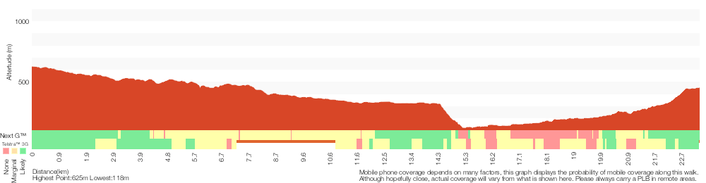
Analysis and summary of the altitude variation on the Woodford to Faulconbridge
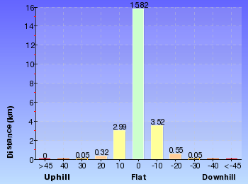
Daily actual walking time estimates
| Day | Walking Time | Length |
|---|---|---|
| 1 | 6 hrs 7 mins | 16.8 km |
| 2 | 3 hrs 7 mins | 7.8 km |
Overview of this walks grade – based on the AS 2156.1 – 2001
Under this standard, a walk is graded based on the most difficult section of the walk.
| Length | 23.4 km | ||
| Time | 2 Days | ||
| . | |||
| Grade 5/6 Experienced only |
AS 2156.1 | Gradient | Very steep (4/6) |
| Quality of track | Rough unclear track (5/6) | ||
| Signs | No directional signs (5/6) | ||
| Experience Required | No experience required (1/6) | ||
| Weather | Weather generally has little impact on safety (1/6) | ||
| Infrastructure | Limited facilities (such as cliffs not fenced, significant creeks not bridged) (4/6) |
Some more details of this walks Grading
Here is a bit more details explaining grading looking at sections of the walk
Gradient
16km of this walk has short steep hills and another 3.8km is very steep. Whilst another 2.9km has gentle hills with occasional steps and the remaining 1.1km is flat with no steps.
Quality of track
11km of this walk follows a rough track, where fallen trees and other obstacles are likely and another 10km follows a formed track, with some branches and other obstacles. Whilst another 1.1km follows a smooth and hardened path and the remaining 960m follows a rough unclear track.
Signs
10km of this walk has directional signs at most intersection and another 10km has minimal directional signs. Whilst another 2.5km is clearly signposted and the remaining 960m Has no directional signs.
Experience Required
This whole walk, 23km requires no previous bushwalking experience.
weather
This whole walk, 23km is not usually affected by severe weather events (that would unexpectedly impact safety and navigation).
Infrastructure
12km of this walk has limited facilities (such as cliffs not fenced, significant creeks not bridged) and another 9km has limited facilities (such as not all cliffs fenced). The remaining (2.5km) is close to useful facilities (such as fenced cliffs and seats).
Similar walks
A list of walks that share part of the track with the Woodford to Faulconbridge walk.
1.2 km Return
1 hr 30 mins
Hard track
3.1 km Return
3 hrs 30 mins
Experienced only
3.5 km Return
2 hrs
Hard track
5.4 km Return
3 hrs 30 mins
Experienced only
6.1 km One way
3 hrs
Hard track
8.6 km Return
3 hrs 30 mins
Hard track
10.5 km Circuit
4 hrs 15 mins
Hard track
11.5 km One way
5 hrs
Hard track
13.5 km One way
6 hrs
Experienced only
13.8 km Circuit
6 hrs 30 mins
Hard track
15.2 km One way
2 Days
Experienced only
15.9 km One way
7 hrs
Experienced only
18.1 km One way
7 hrs
Hard track
18.3 km One way
7 hrs 15 mins
Experienced only
29.6 km One way
3 Days
Hard track
Other Nearby walks
A list of walks that start near the Woodford to Faulconbridge walk.
180 m Return
15 mins
Moderate track
1.6 km One way
45 mins
Easy track
2.6 km Circuit
1 hr 30 mins
Hard track
2.9 km One way
2 hrs
Hard track
1.3 km Return
1 Hr
Moderate track
1.7 km Circuit
1 Hr
Hard track
2.2 km Circuit
1 hr 30 mins
Hard track
2 km Circuit
1 hr 30 mins
Moderate track
746 m Return
45 mins
Moderate track
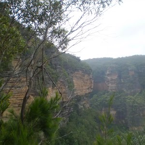
1.3 km Circuit
45 mins
Moderate track
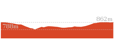

926 m Return
45 mins
Hard track
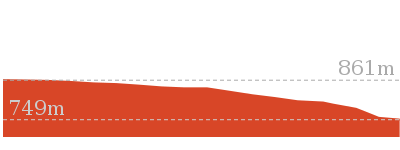
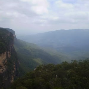
1.5 km Return
45 mins
Moderate track
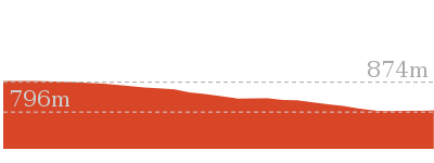
Plan your trip to and from the walk here
The Woodford to Faulconbridge walk starts at the Woodford Station (gps: -33.735763, 150.48228)
Your transport options to Woodford Station are by;
![]() Train. (get details)
Train. (get details)
![]() Bus. (get details)
Bus. (get details)
![]() Car. There is free parking available.
Car. There is free parking available.
(get details)
![]() Train. (get details)
Train. (get details)
The Woodford to Faulconbridge ends at the Faulconbridge Station (gps: -33.69662, 150.53487)
Your transport options to Faulconbridge Station are by;
![]() Bus. (get details)
Bus. (get details)
![]() Car. There is free parking available.
Car. There is free parking available.
(get details)
Short URL = http://wild.tl/wtf
Gallery images
There are other downloads I am still working on.
You will probably need to login to access these — still all free.
* KML (google earth file)
* GPX (GPS file)
Special Maps/ brochures
* A3 topo maps
* PDF with Lands Topo map base
* PDF with arial image (and map overlay)
I wanted to get the main site live first, this extra stuff will come in time.
Happy walking
Matt 🙂
Woodford to Glenbrook
And Walk
Woodford to Glenbrook

3 Days
29.6 km One way
731 m
Hard track
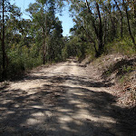
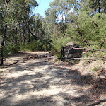
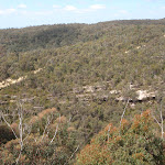
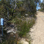
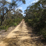
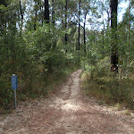

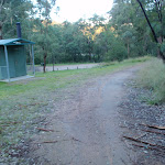
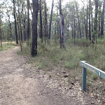
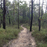
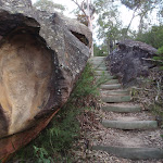
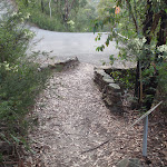
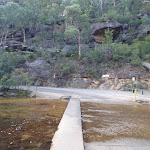
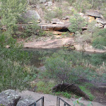


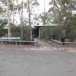
Woodford
Woodford is situated along the Great Western Highway in the Blue Mountains. Woodford boasts one of the Blue Mountains oldest buildings, with the Woodford Academy dating back to 1833 . Access to the academy is made easy by Woodford train station and other public transport connections. Woodford is also the start of the popular Woodford to Glenbrook mountain bike which follows the Oaks Fire trail. Woodford station offers a public telephone and toilets. There are no commercial facilities in the area.
(0km) Woodford Station → Int. Oaks Firetrail and Old Bathurst Rd
730 m
15 mins
22m
-39m
Easy track
From the station, this walk heads down the stairs, off the station and turns left under the station. It then continues up to Railway Parade, opposite a shelter with a bench seat. The walk heads up Railway Pde, keeping the railway tracks to the left. The road tends right then the walk turns right onto The Appian Way. The walk follows The Appian Way, which turns into Parker St. (If you cross over a bridge, you have gone the wrong way.) The walk leads along Parker St to Taylor St, where it turns left and continues down the hill to the intersection with The Oaks Fire Trail. This is signposted at the clearing on the right.
(0.73km) Int. Oaks Firetrail and Old Bathurst Rd → Int. Oaks Firetrail and cliff lookout Trk
3.5 km
1 hr 10 mins
87m
-175m
Moderate track
Turn right: From the road, the walk heads to the gate and crosses over it. (On the lower side of the gate is a tap which provides drinking water.) From the gate and tap, the walk heads down the hill, passing a broken interpretative sign on the left, and continues to wind and undulate for quite some time. The trail passes a mound in a junction. From the mound, the trail continues to wind and undulate, turning right and steeply downhill twice, before passing a small dam (just to the left). The walk winds, with the hillside higher on the right than left, before leading up a steep slope to a small clearing with a large step.
(4.21km) Int. Oaks Firetrail and cliff lookout Trk → Cliff lookout
100 m
3 mins
5m
-18m
Hard track
Turn right: From the intersection, the walk heads away from the management trail, with the small depression (or waterhole) on the left, surrounded by reeds. The track winds up the hill, following the gap in the vegetation, leading to a rock shelf with a view. At the end of this side trip, retrace your steps back to the main walk then Turn right.
Cliff Lookout
Cliff lookout, an unofficially-named, informal view point, is a dramatic cliff edge perched just above the trees. The cliff is unfenced. The view across the valley provides a pleasant panorama.
(4.21km) Int. Oaks Firetrail and cliff lookout Trk → Int. Wheel Gully Trail and Oaks Firetrail
7.9 km
2 hrs 45 mins
318m
-316m
Hard track
Continue straight: From the intersection, the walk heads down the hill in a southerly direction and tends right. At the bottom of the hill, the trail winds left and then up a hill to the right, onto a plateau with clearer, lower vegetation. The management trail here is also lined by large rocks, which look as though they could have been placed there. The trail comes off the hill and heads across a saddle to a large management trail intersection (on the left).
Continue straight: From the intersection, the walk heads south up the hill, passing a blue marker sign soon after leaving the intersection. The track then continues up onto the ridge top, then follows the high ground for some time. The track along the ridgeline is surrounded by rocky surfaces and lower vegetation which lends views of the surrounding valleys. The track begins to descend after winding over and around the ridgeline for some time. As the track descends, it passes a rock shelf to the right of the track, which has good views over the valley. The track continues down the hill into a saddle with an intersection with a gate, to the left.
Continue straight: From the intersection in the saddle the track heads up the hill for a short time. The track climbs up onto a plateau where the track is bordered by rocky surfaces and low scrub across the ridge line. This plateau is then left as the track descends slightly as the track winds along the hillside for some time to wind right, coming quickly to the intersection.
(12.09km) Int. Wheel Gully Trail and Oaks Firetrail → Int. in Wheel Gully loop
100 m
2 mins
0m
-16m
Moderate track
Turn left: From the intersection, the walk heads down the hill, almost immediately coming to a split in the track, with both tracks heading down the hill.
Wheel Gully
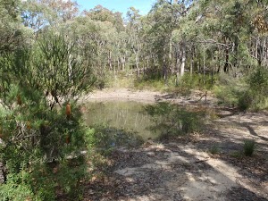
Wheel Gully has a management trail which loops down to a large dam. It is a nice shady place to stop for a bite to eat along the Oaks Fire Trail. This site is also used as an informal campsite with no facilities. The water in the dam is not suitable for drinking, nor is it reliable. Carry enough water.
End of day 1
This is the planned overnight stay for the end of day 1, happy camping.
(12.19km) Int. in Wheel Gully loop → Int. Wheel Gully Trail and Oaks Firetrail
100 m
2 mins
16m
0m
Moderate track
Turn around: From the intersection, the walk heads up the hill to the intersection with the Oaks Fire Trail.
(12.29km) Int. Wheel Gully Trail and Oaks Firetrail → The Oaks Picnic Area
6 km
1 hr 59 mins
26m
-270m
Moderate track
Turn left: From the intersection, the walk heads in a southerly direction away from the turn in the trail. The walk soon passes a large clearing on the right and begins the slow descent that winds down the hill. The trail begins to tend left as it swings south-east, passing a few smaller clearings with demolished trees in them. This continues along the Oaks Fire Trail to a blue sign, which is marked ‘Woodford 15km’ on the other side.
Continue straight: From the intersection, the walk heads down a slight slope. The trail drops down some steeper sections as the trail generally descends at a gentle gradient, winding slightly as it leads down to a gate and interpretative sign before an intersection.
Continue straight: From the intersection, the walk heads east, directly away from the gate and sign to the bend in the management trail.
Continue straight: From the intersection, the walk heads away from both the ’40’ sign and the gate, heading east down the management trail. The walk soon comes to the intersection, signposted ‘Red Hands Cave’.
Veer right: From the intersection, the walk heads in an easterly direction along the management trail, tending left around to the Oaks Picnic Area on the left and the car park on the right.
The Oaks Picnic Area
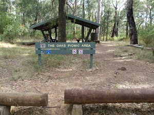
The Oaks Picnic Area, is an established picnic area with shelter, bench seats and a pit toilet. The picnic area also boasts a water tank and adequate parking. It is a quiet area, just off the road, making it a fantastic spot for a rendezvous with family and friends after a long walk or ride.
(18.32km) The Oaks Picnic Area → Int. Oaks Picnic Area Trk and Oaks single Trk
70 m
1 mins
2m
0m
Moderate track
Turn left: From the picnic area, the walk heads past the water tank, then towards the green-roofed toilet in the bush. The track passes the toilet (on the right) before coming to the fire trail.
(18.39km) Int. Oaks Picnic Area Trk and Oaks single Trk → 5km to Glenbrook Sign
2.3 km
38 mins
5m
-72m
Moderate track
Turn right: From the intersection, the walk follows the ‘Glenbrook’ sign down the trail. The trail narrows quickly and winds east for some time, through the thick green heath and burnt trees. The track splits at one point and connects again a few metres on, before continuing to the signposted intersection where the track opens up in a clearing.
(20.65km) 5km to Glenbrook Sign → The Ironbark Picnic Area
2.7 km
46 mins
8m
-52m
Moderate track
Continue straight: From the intersection, this walk follows the clear track to the east, passing the blue ‘Shared use’ sign. The track meanders through the bush for some time before passing a few short tracks on the right. This walk stays on the main cycleway until passing between two white gum trees and coming to an intersection with the Ironbark access track on the right, marked with another blue ‘shared use’ sign.
Turn right: From the intersection, the walk follows the narrower track east towards the road. The track opens up at the car park, and the walk crosses the road to the Ironbark picnic area.
Turn right: From the intersection, the walk follows the narrower track east towards the road. The track opens up at the car park, and the walk crosses the road to the Ironbark picnic area.
Ironbark Picnic Area
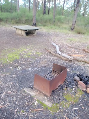
Ironbark Picnic Area is a basic picnic area on the Oaks Fire Trail, about 450m south of Euroka Rd. The picnic area has a low bench that acts as both a table and seat, and there is also a wood-fired barbecue provided. The picnic area is at the top of a gated management trail, which leads down to campsites at Euroka. There are plenty of car parking spaces provided and it is a fairly popular starting point for people cycling the Oaks Cycleway.
(23.38km) The Ironbark Picnic Area → Top of Darug campsite car park
1.6 km
30 mins
8m
-98m
Moderate track
Continue straight: From the Ironbark Picnic Area, this walk follows the management trail south east by first stepping over the locked gate (pole). The wide trail then gently leads downhill. As the hill steepens a bit, the track becomes narrower. As the track approaches Euroka, there are a few sharp bends and the walk leads to the top of Nioka. The campsite comes into view, and the walk continues down the clear track, now with the camp ground on the right. The track then passes a toilet and continues down around the locked gate to the dirt road intersection just below Nioka campsite.
Veer left: From the dirt road just below the signposted ‘Nioka’ campsite, this walk follows the main road, initially keeping the campsite to the left. The walk heads across a small, bridged creek crossing and up to the intersection. At the intersection, there are some information signs about the area (on the right).
Continue straight: From the signposts, the walk follows the ‘Daruk’[2] arrow along the flat dirt road, keeping the hill up to the left. After passing the garbage bins, the trail crosses a small creek and comes to an intersection with a bush track on the left, just before the signposted ‘Darug’ campsite.
Euroka Campground – Darug
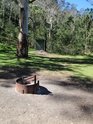
The Darug (sometimes labeled Daruk) campsite is found the Euroka Clearing, in the Glenbrook region of the Blue Mountains National Park. There are about 20 camping spaces to choose from in this area. Tap water is available at the park entrance. The campsite has a wheelchair-accessible toilet (access over grassy terrain) and a few metal fireplaces. The campsite is surrounded by large gum trees and is right at the base of a steep hill to the north.
End of day 2
This is the planned overnight stay for the end of day 2, happy camping.
(24.93km) Top of Darug campsite car park → Int. Euroka Trk and The Oaks Fire Trail
2.3 km
51 mins
111m
-103m
Hard track
Turn left: From between the small creek crossing and the ‘Darug’ campsite, the walk follows the bush track up the hill, initially keeping Darug to the right. There are two tracks at time of writing, nearly parallel and heading to the same place. The track becomes steep and works its way up the steep rocky hill. At the top of this climb, the walk follows the track to the right and then the clear track meanders through the scrub. The track soon comes to an intersection with the signposted ‘Portal waterhole’ track (which heads off to the right).
Continue straight: From the intersection, the walk heads north, following neither of the arrows on the sign. The track soon comes to Mount Portal Trail, just next to the intersection with Euroka Road.
Veer right: From the intersection, the walk follows the ‘The Causeway’ sign, along the bush track. The track tends right into the low grassy bush. As the track continues down the hill, the grass gives way to wattle bush covering the gully. The track leads down many stairs then crosses a creek or two before winding along the hillside. The track then continues down into the gully to pass a fading track, on the left, then winds through to a hairpin corner on the road, marked by a ‘Euroka Track’ sign (pointing back the way you came).
(27.24km) Int. Euroka Trk and The Oaks Fire Trail → Eastern side of Causeway
230 m
5 mins
0m
-28m
Moderate track
Veer right: From the intersection, the walk heads down the steep road to the causeway.
Veer right: From the southern side of the causeway, the walk heads across the causeway to the road, next to the fenced, paved area. The causeway may be impassable after rain.
Veer right: From the southern side of the causeway, the walk heads across the causeway to the road, next to the fenced, paved area. The causeway may be impassable after rain.
Glenbrook causeway
Glenbrook causeway is the only way for vehicles to cross Glenbrook Creek. It is a concrete road, with a raised gutter for pedestrians to cross the creek. The causeway is subject to flooding. Glenbrook causeway is a crossing point for many of the popular walks throughout the Glenbrook Valley area.
(27.48km) Eastern side of Causeway → Jelly Bean Pool
320 m
6 mins
5m
-6m
Hard track
Turn right: From the causeway, the walk heads through the blocked-off paved area, keeping the water on the right. The walk heads alongside the creek (the track is not very clear at this point) but winds around and over the large rocks beside the main creek (This creek does become impassable after heavy or prolonged rain). The soon the creek widens and turns into a large pool, where the track leads around the rocky outcrop to a metal staircase, above Jellybean Pool.
Jellybean Pool
Jellybean Pool is a large pool in Glenbrook Creek, just south of the weir. The pool has a few sandy beaches, rock platforms and is surrounded by cliffs. Jumping and diving is not a good idea, and is not permitted. This is a popular spot for locals to swim. Swimming can be dangerous – the creek is especially dangerous after rain. Check with rangers before heading in.
(27.79km) Jelly Bean Pool → Glenbrook Information Centre car park
500 m
13 mins
88m
-3m
Moderate track
Turn left: From the bottom of the metal stairs, the walk heads up the stairs away from Jellybean Pool. The track heads under the rocks then turns left up to a set of bins, at the bottom of the car park.
Continue straight: From the bins, the walk heads up to the top of the car park to the sealed road. The walk soon turns right, up the stairs and into the bush. The walk heads up many stairs, crossing the road twice along the way. The track winds around a rocky outcrop and enters a small grassed area with bench seats. The walk continues past these seats to the bottom of the car park, at the front of the Glenbrook Information Centre.
Continue straight: From the bins, the walk heads up to the top of the car park to the sealed road. The walk soon turns right, up the stairs and into the bush. The walk heads up many stairs, crossing the road twice along the way. The track winds around a rocky outcrop and enters a small grassed area with bench seats. The walk continues past these seats to the bottom of the car park, at the front of the Glenbrook Information Centre.
NPWS Glenbrook Information Centre
The NPWS information centre and car park are found just before the ‘toll both’ on Bruce Road. You will find tap water, toilets, garbage bins and information signs about the region. A great spot to chat to staff and get updates on the conditions in the park.
(28.29km) Glenbrook Information Centre car park → Glenbrook Station
1.3 km
23 mins
35m
-13m
Moderate track
Continue straight: From the car park, the walk joins the road and heads up the hill. The walk continues along the road, Bruce Rd, over a bridge and winds for some time. The walk follows the footpath on the left of the road, continuing as Bruce Rd becomes Burfitt Pde. The walk passes Euroka Rd on the right and soon comes to Glenbrook Station on the left.
Glenbrook
Glenbrook is situated on the Great Western Highway and is a tourist hub for the lower Blue Mountains, with the Blue Mountains Visitor Information Centre located here. Glenbrook has quite a bustling little town centre with a number of cafes, bakeries and shops to explore. Prior to 1879, Glenbrook had changed its name numerous times, known at various times as Watertank, Wascoe Siding and Brookdale before being given its current name by Sir John Jamieson. Glenbrook is a gateway into the Blue Mountains National Park and is also the end point of the Woodford-Glenbrook mountain bike trail, along the Oaks Fire Trail. More info.
Maps for the Woodford to Glenbrook walk
You can download the PDF for this walk to print a map.
These maps below cover the walk and the wider area around the walk, they are worth carrying for safety reasons.
| Springwood | 1:25 000 Map Series | 90304S SPRINGWOOD | NSW-90304S |
| Penrith | 1:25 000 Map Series | 90303N PENRITH | NSW-90303N |
| Jamison | 1:25 000 Map Series | 89302N JAMISON | NSW-89302N |
| Katoomba | 1:25 000 Map Series | 89301S KATOOMBA | NSW-89301S |
| Penrith | 1:100 000 Map Series | 9030 PENRITH | 9030 |
| Katoomba | 1:100 000 Map Series | 8930 KATOOMBA | 8930 |
Cross sectional view of the Woodford to Glenbrook bushwalking track

Analysis and summary of the altitude variation on the Woodford to Glenbrook

Daily actual walking time estimates
| Day | Walking Time | Length |
|---|---|---|
| 1 | 4 hrs 15 mins | 12.3 km |
| 2 | 3 hrs 56 mins | 12.7 km |
| 3 | 1 hr 38 mins | 4.6 km |
Overview of this walks grade – based on the AS 2156.1 – 2001
Under this standard, a walk is graded based on the most difficult section of the walk.
| Length | 29.6 km | ||
| Time | 3 Days | ||
| . | |||
| Grade 4/6 Hard track |
AS 2156.1 | Gradient | Very steep (4/6) |
| Quality of track | Rough track, where fallen trees and other obstacles are likely (4/6) | ||
| Signs | Minimal directional signs (4/6) | ||
| Experience Required | Moderate level of bushwalking experience recommended (4/6) | ||
| Weather | Storms may impact on navigation and safety (3/6) | ||
| Infrastructure | Limited facilities, not all cliffs are fenced (3/6) |
Some more details of this walks Grading
Here is a bit more details explaining grading looking at sections of the walk
Gradient
14km of this walk has short steep hills and another 6km is very steep. Whilst another 6km has gentle hills with occasional steps and the remaining 3km is flat with no steps.
Quality of track
16km of this walk follows a formed track, with some branches and other obstacles and another 11km follows a clear and well formed track or trail. Whilst another 2.5km follows a smooth and hardened path and the remaining 320m follows a rough track, where fallen trees and other obstacles are likely.
Signs
21km of this walk has directional signs at most intersection and another 4.5km is clearly signposted. The remaining (4.3km) has minimal directional signs.
Experience Required
27km of this walk requires no previous bushwalking experience and another 1.9km requires some bushwalking experience. The remaining (320m) requires a leader a with moderate level of bushwalking experience.
weather
Around 29km of this walk is not usually affected by severe weather events (that would unexpectedly impact safety and navigation), whilst the remaining 330m is affected by storms that may impact your navigation and safety.
Infrastructure
Around 25km of this walk has limited facilities (such as not all cliffs fenced), whilst the remaining 4.1km is close to useful facilities (such as fenced cliffs and seats).
Similar walks
A list of walks that share part of the track with the Woodford to Glenbrook walk.
218 m Return
20 mins
Moderate track
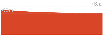
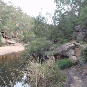
1 km Return
45 mins
Moderate track
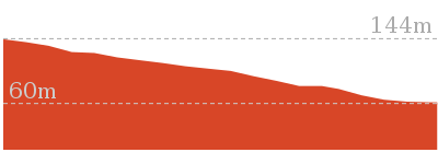
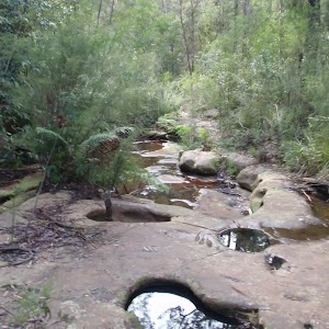
4.3 km One way
1 hr 45 mins
Experienced only
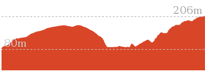
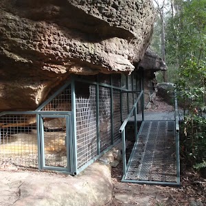
4.4 km One way
2 hrs
Hard track
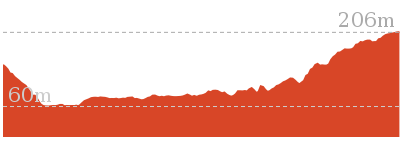
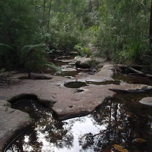
8.4 km Circuit
3 hrs 45 mins
Experienced only
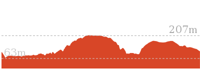
8.6 km Return
3 hrs 30 mins
Hard track
15.9 km One way
7 hrs
Experienced only
16.6 km Circuit
2 Days
Experienced only
18.1 km One way
7 hrs
Hard track
18.3 km One way
7 hrs 15 mins
Experienced only
18.8 km One way
2 Days
Very experienced only
23.4 km One way
2 Days
Experienced only
Other Nearby walks
A list of walks that start near the Woodford to Glenbrook walk.
180 m Return
15 mins
Moderate track
3.1 km Return
3 hrs 30 mins
Experienced only
1.2 km Return
1 hr 30 mins
Hard track
5.4 km Return
3 hrs 30 mins
Experienced only
1.6 km One way
45 mins
Easy track
2.6 km Circuit
1 hr 30 mins
Hard track
2.9 km One way
2 hrs
Hard track
1.3 km Return
1 Hr
Moderate track
1.7 km Circuit
1 Hr
Hard track
2.2 km Circuit
1 hr 30 mins
Hard track
2 km Circuit
1 hr 30 mins
Moderate track
15.2 km One way
2 Days
Experienced only
Plan your trip to and from the walk here
The Woodford to Glenbrook walk starts at the Woodford Station (gps: -33.735763, 150.48228)
Your transport options to Woodford Station are by;
![]() Train. (get details)
Train. (get details)
![]() Bus. (get details)
Bus. (get details)
![]() Car. There is free parking available.
Car. There is free parking available.
(get details)
The Woodford to Glenbrook ends at the Glenbrook Station (gps: -33.768939, 150.62134)
Your transport options to Glenbrook Station are by;
![]() Train. (get details)
Train. (get details)
![]() Bus. (get details)
Bus. (get details)
![]() Car. There is free parking available.
Car. There is free parking available.
(get details)
Short URL = http://wild.tl/wtg
Gallery images
There are other downloads I am still working on.
You will probably need to login to access these — still all free.
* KML (google earth file)
* GPX (GPS file)
Special Maps/ brochures
* A3 topo maps
* PDF with Lands Topo map base
* PDF with arial image (and map overlay)
I wanted to get the main site live first, this extra stuff will come in time.
Happy walking
Matt 🙂
Raymond Rd to Lawsons Lookout
And Walk
Raymond Rd to Lawsons Lookout

15 mins
202 m Return
20 m
Moderate track
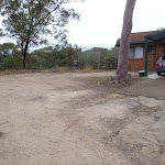
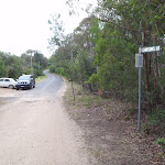

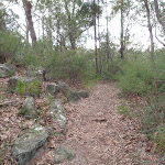
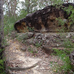
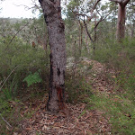
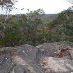

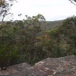
(0km) End of Raymond Rd → Lawsons Lookout
100 m
3 mins
3m
-17m
Moderate track
From opposite 86 Raymond Rd, the track follows the direction of the ‘Lawsons Lookout’ sign[1], down the track. The walk winds past a few rocky outcrops to an unfenced rock surface next on the cliff edge, Lawsons Lookout.
Lawsons Lookout
Lawsons Lookout, in Springwood, Blue Mountains, is an unfenced rockshelf overlooking the wonderful Magdala Creek valley. The lookout is most easily accessed from Raymond Rd.
Maps for the Raymond Rd to Lawsons Lookout walk
You can download the PDF for this walk to print a map.
These maps below cover the walk and the wider area around the walk, they are worth carrying for safety reasons.
| Springwood | 1:25 000 Map Series | 90304S SPRINGWOOD | NSW-90304S |
| Penrith | 1:100 000 Map Series | 9030 PENRITH | 9030 |
Cross sectional view of the Raymond Rd to Lawsons Lookout bushwalking track
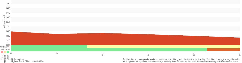
Analysis and summary of the altitude variation on the Raymond Rd to Lawsons Lookout
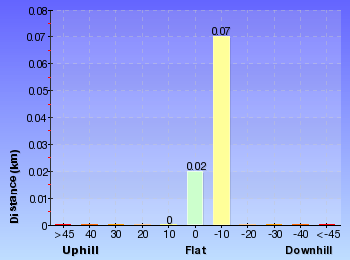
Overview of this walks grade – based on the AS 2156.1 – 2001
Under this standard, a walk is graded based on the most difficult section of the walk.
| Length | 202 m | ||
| Time | 15 mins | ||
| . | |||
| Grade 3/6 Moderate track |
AS 2156.1 | Gradient | Short steep hills (3/6) |
| Quality of track | Formed track, with some branches and other obstacles (3/6) | ||
| Signs | Directional signs along the way (3/6) | ||
| Experience Required | No experience required (1/6) | ||
| Weather | Weather generally has little impact on safety (1/6) | ||
| Infrastructure | Generally useful facilities (such as fenced cliffs and seats) (1/6) |
Some more details of this walks Grading
Here is a bit more details explaining grading looking at sections of the walk
Gradient
This whole walk, 100m has short steep hills.
Quality of track
This whole walk, 100m follows a formed track, with some branches and other obstacles.
Signs
This whole walk, 100m has directional signs at most intersection.
Experience Required
This whole walk, 100m requires no previous bushwalking experience.
weather
This whole walk, 100m is not usually affected by severe weather events (that would unexpectedly impact safety and navigation).
Infrastructure
This whole walk, 100m is close to useful facilities (such as fenced cliffs and seats).
Similar walks
A list of walks that share part of the track with the Raymond Rd to Lawsons Lookout walk.
2.7 km Return
1 hr 30 mins
Hard track
Other Nearby walks
A list of walks that start near the Raymond Rd to Lawsons Lookout walk.
13.8 km Circuit
6 hrs 30 mins
Hard track
10.5 km Circuit
4 hrs 15 mins
Hard track
13.5 km One way
6 hrs
Experienced only
11.5 km One way
5 hrs
Hard track
9 km Return
4 hrs
Hard track
15.2 km One way
2 Days
Experienced only
3.5 km Return
2 hrs
Hard track
6.1 km One way
3 hrs
Hard track
180 m Return
15 mins
Moderate track
3.1 km Return
3 hrs 30 mins
Experienced only
1.2 km Return
1 hr 30 mins
Hard track
5.4 km Return
3 hrs 30 mins
Experienced only
Plan your trip to and from the walk here
The Raymond Rd to Lawsons Lookout walk starts and ends at the End of Raymond Rd (gps: -33.706077, 150.56627)
Your transport options to End of Raymond Rd are by;
![]() Train. (get details)
Train. (get details)
![]() Bus. (get details)
Bus. (get details)
![]() Car. There is free parking available.
Car. There is free parking available.
(get details)
Short URL = http://wild.tl/llfrr
Gallery images
There are other downloads I am still working on.
You will probably need to login to access these — still all free.
* KML (google earth file)
* GPX (GPS file)
Special Maps/ brochures
* A3 topo maps
* PDF with Lands Topo map base
* PDF with arial image (and map overlay)
I wanted to get the main site live first, this extra stuff will come in time.
Happy walking
Matt 🙂
Lawson Lookout from Fairy Dell Reserve

1 hr 30 mins
2.7 km Return
149 m
Hard track
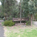

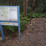
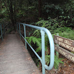

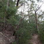
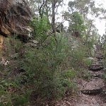
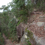
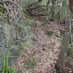
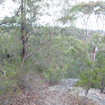
Springwood
Springwood, along the Great Western Highway, is the second largest town in the Blue Mountains. Springwood also takes the title for the oldest railway station in the Blue Mountains. There are a variety of shops in Springwood, with quite a few cafes, bakeries and two historic hotels. Springwood was named by Governor Macquarie, when his wife and he stopped for water from a deep glen spring, in 1815. It seems aptly named, with many springs and creeks leading away from the ridge at Springwood, including Sassafras Gully, Magdala Creek and Glenbrook Creek. More info.
(0km) Springwood Station → Int. Springwood Ave and Fairy Dell Reserve
270 m
5 mins
4m
-11m
Very easy
From Springwood Station, the walk crosses the road at the pedestrian crossing and turns left. The walk continues past the shop front for about 150 metres before turning right at a quadrangle, which leads the walk down through a car park. The walk passes through the car park and crosses Macquarie Rd, to the ‘Fariy Dell’ sign[4].
(0.27km) Int. Springwood Ave and Fairy Dell Reserve → Fairy Dell Reserve picnic area
150 m
3 mins
0m
-21m
Easy track
Continue straight: From the ‘Fairy Dell, 49 Springwood Ave’ sign[5], the walk heads downhill into the reserve (along the smaller road), past the signs. The walk winds down past the units (on the left) to the bottom of the road. The walk continues on the left side of the cul-de-sac, to a grassy area with picnic tables.
Fairy Dell Reserve picnic area
Fairy Dell Reserve picnic area is a quiet and shady terraced garden at the head of the Magdala Gully. Fairy Dell is situated just south of Springwood in the Lower Blue Mountains. The picnic area has numerous tables, parking and a grassy area for the kids to play. The Fairy Dell Reserve Picnic area is also the starting point for a number of walks down to Magdala Creek, Picnic Point and nearby Lawson Lookout.
(0.41km) Fairy Dell Reserve picnic area → Int. Fairy Dell and Picnic Point Tracks
390 m
9 mins
5m
-44m
Hard track
Veer left: From the picnic area, the walk follows the ‘Sassafras Gully’ sign down the stairs. The walk quickly passes the vandalised building (which has since been reported as demolished by another walker), then a map sign before meeting a creek. The walk keeps the creek on the right and soon comes to a bridge with direction signs.
(0.8km) Int. Fairy Dell and Picnic Point Tracks → Picnic Point
160 m
6 mins
33m
-2m
Hard track
Turn right: From the intersection, the walk crosses the bridge, following the ‘Picnic Point’ signs[6]. The walk immediately climbs many stairs which wind up to a the picnic shelter and grass area of Picnic Point. At the end of this side trip, retrace your steps back to the main walk then Turn right.
Picnic Point
Picnic Point, in Springwood, Blue Mountains, is a quiet, grassy clearing tucked behind the houses above Magdala Creek. The area has a gazebo, picnic table and water tank (water needs to be treated). The clearing has a track leading down to many popular walks, with Lawson’s Lookout and Fairy Dell Reserves nearby.
(0.8km) Int. Fairy Dell and Picnic Point Tracks → Int. Lawsons Lookout Trk and Fairy Dell Trk
140 m
3 mins
1m
-13m
Moderate track
Continue straight: From the intersection at the bridge, the walk heads in the direction of the ‘Perch Ponds’ arrow[7], keeping the creek on the right of the track. The walk soon comes to a ‘Lawson’s Lookout’ sign[ref img=146352, above a cascade in the creek.
(0.94km) Int. Lawsons Lookout Trk and Fairy Dell Trk → Lawsons Lookout
410 m
11 mins
39m
-11m
Hard track
Turn left: From the intersection, the walk follows the direction of the ‘Lawsons Lookout’ signs[8], up the hill. The track heads up to a rocky outcrop, where the track turns back on itself and steps through some bushes to the rocky surface of the lookout.
Lawsons Lookout
Lawsons Lookout, in Springwood, Blue Mountains, is an unfenced rockshelf overlooking the wonderful Magdala Creek valley. The lookout is most easily accessed from Raymond Rd.
(1.35km) Lawsons Lookout → End of Raymond Rd
100 m
3 mins
17m
-3m
Moderate track
Turn sharp right: From Lawsons Lookout, the walk heads directly away from the view, heading up the hill. The walk soon passes a rocky outcrop and heads towards the houses as it winds up to the unsealed cul-de-sac at the end of the road (opposite 86 Raymond Rd).
Maps for the Lawson Lookout from Fairy Dell Reserve walk
You can download the PDF for this walk to print a map.
These maps below cover the walk and the wider area around the walk, they are worth carrying for safety reasons.
| Springwood | 1:25 000 Map Series | 90304S SPRINGWOOD | NSW-90304S |
| Penrith | 1:100 000 Map Series | 9030 PENRITH | 9030 |
Cross sectional view of the Lawson Lookout from Fairy Dell Reserve bushwalking track
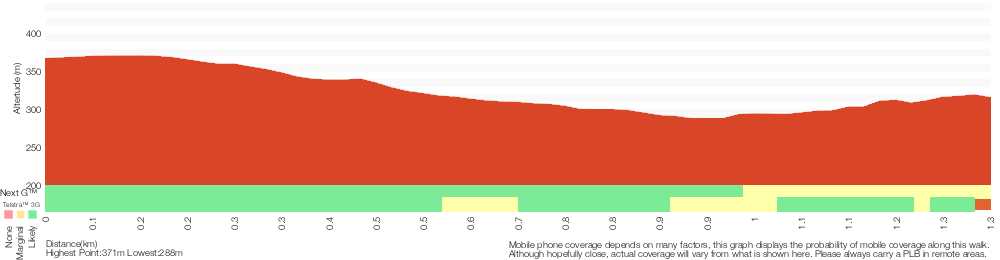
Analysis and summary of the altitude variation on the Lawson Lookout from Fairy Dell Reserve
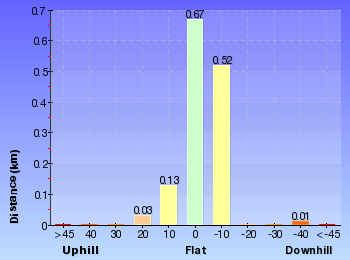
Overview of this walks grade – based on the AS 2156.1 – 2001
Under this standard, a walk is graded based on the most difficult section of the walk.
| Length | 2.7 km | ||
| Time | 1 hr 30 mins | ||
| . | |||
| Grade 4/6 Hard track |
AS 2156.1 | Gradient | Very steep (4/6) |
| Quality of track | Formed track, with some branches and other obstacles (3/6) | ||
| Signs | Directional signs along the way (3/6) | ||
| Experience Required | No experience required (1/6) | ||
| Weather | Weather generally has little impact on safety (1/6) | ||
| Infrastructure | Limited facilities (such as cliffs not fenced, significant creeks not bridged) (4/6) |
Some more details of this walks Grading
Here is a bit more details explaining grading looking at sections of the walk
Gradient
800m of this walk is very steep and another 270m is flat with no steps. Whilst another 150m has gentle hills with occasional steps and the remaining 140m has short steep hills.
Quality of track
Around 930m of this walk follows a formed track, with some branches and other obstacles, whilst the remaining 410m follows a smooth and hardened path.
Signs
Around 930m of this walk has directional signs at most intersection, whilst the remaining 410m is clearly signposted.
Experience Required
This whole walk, 1.3km requires no previous bushwalking experience.
weather
This whole walk, 1.3km is not usually affected by severe weather events (that would unexpectedly impact safety and navigation).
Infrastructure
800m of this walk is close to useful facilities (such as fenced cliffs and seats) and another 410m has limited facilities (such as cliffs not fenced, significant creeks not bridged). The remaining (140m) has limited facilities (such as not all cliffs fenced).
Similar walks
A list of walks that share part of the track with the Lawson Lookout from Fairy Dell Reserve walk.
202 m Return
15 mins
Moderate track
9 km Return
4 hrs
Hard track
10.5 km Circuit
4 hrs 15 mins
Hard track
11.5 km One way
5 hrs
Hard track
13.5 km One way
6 hrs
Experienced only
13.8 km Circuit
6 hrs 30 mins
Hard track
Other Nearby walks
A list of walks that start near the Lawson Lookout from Fairy Dell Reserve walk.
15.2 km One way
2 Days
Experienced only
3.5 km Return
2 hrs
Hard track
6.1 km One way
3 hrs
Hard track
180 m Return
15 mins
Moderate track
3.1 km Return
3 hrs 30 mins
Experienced only
1.2 km Return
1 hr 30 mins
Hard track
5.4 km Return
3 hrs 30 mins
Experienced only
15.9 km One way
7 hrs
Experienced only
2.6 km Circuit
1 hr 30 mins
Hard track
2.9 km One way
2 hrs
Hard track
4.3 km Circuit
2 hrs 30 mins
Hard track
4 km Return
2 hrs
Hard track
Plan your trip to and from the walk here
The Lawson Lookout from Fairy Dell Reserve walk starts and ends at the Springwood Station (gps: -33.699102, 150.5638)
Your transport options to Springwood Station are by;
![]() Train. (get details)
Train. (get details)
![]() Bus. (get details)
Bus. (get details)
![]() Car. There is free parking available.
Car. There is free parking available.
(get details)
Short URL = http://wild.tl/fdtll
Gallery images
There are other downloads I am still working on.
You will probably need to login to access these — still all free.
* KML (google earth file)
* GPX (GPS file)
Special Maps/ brochures
* A3 topo maps
* PDF with Lands Topo map base
* PDF with arial image (and map overlay)
I wanted to get the main site live first, this extra stuff will come in time.
Happy walking
Matt 🙂
Clarinda Falls from Faulconbridge
And Walk
Clarinda Falls from Faulconbridge

2 hrs
3.5 km Return
219 m
Hard track
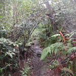
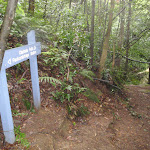

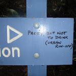
Faulconbridge
Faulconbridge, in the Blue Mountains, New South Wales, was named after the maiden name of Sir Henry Parkes’ mother. Faulconbridge sits on the Great Western Highway and is surrounded by valleys of lush bushland. This picturesque town was a home, and final resting place, for Sir Henry Parkes’, heralded as the ‘Father of Federation’. Faulconbridge was originally explored by non-indigenous Australians in 1813, by Blaxland, Wentworth and Lawson who were searching for a route over the Blue Mountains .
(0km) Faulconbridge Station → No. 10 Sir Henrys Pde
410 m
8 mins
10m
-16m
Moderate track
From the top of Faulconbridge Station, the walk heads off the station overpass to the bushland side of the station (if you come to a car park, you have gone to the wrong side of the station). The walk then keeps the rail line on the left as it follows the footpath down to the road. After a while, the walk comes to an intersection with Sir Henrys Pde, opposite house number 10.
Victory Track
The Victory Track is more formally know as the ‘Sir Henry Parkes Victory Track’[4] and is called the ‘Victoria Track’ in many guide books. The track starts near Sir Henry Parkes’ grave in Faulconbridge and leads to Sassafrass Gully Creek. Sir Henry Parks (1815-1896) was a politician and journalist, born in England. He is considered to be the ‘Father of Federation’ for Australia, although he died of natural causes 5 years before Australia’s federation. Parkes was the premier of New South Wales five times. The town Parkes was named in his honour. Parkes would sometime write under the pseudonym ‘Faulconbridge’ (his mothers maiden name) for the Sydney Morning Herald and other papers and Faulconbridge (the township) was named after his mother when Parkes purchased 600 acres in 1877. More info.
(0.41km) No. 10 Sir Henrys Pde → Clarinda Falls
1.3 km
39 mins
16m
-177m
Hard track
Turn right: From 10 Sir Henrys Pde (bushland side), the walk follows the ‘Victory Track’ sign down into the bush. The walk passes under a few rock overhangs and then crosses a creek. Passing a smaller track (on the left, which leads to the top of the falls), the walk soon comes down to a ‘Clarinda Falls’ sign[10].
Turn left: From the intersection, the track follows the ‘Clarinda Falls’ sign[11] towards the log fallen on the rock. The track tends left around the hillside, coming to Clarinda Falls.
Turn left: From the intersection, the track follows the ‘Clarinda Falls’ sign[11] towards the log fallen on the rock. The track tends left around the hillside, coming to Clarinda Falls.
Clarinda Falls
Clarinda Falls is a charming waterfall on Sassafras Creek. The water cascades over a near-vertical wall, into a sandy pool below. The falls are signposted from the main track and provide a nice cool detour, especially on warmer days. The falls are named for the first wife of Sir Henry Parkes, ‘Father of Australian Federation’.
Maps for the Clarinda Falls from Faulconbridge walk
You can download the PDF for this walk to print a map.
These maps below cover the walk and the wider area around the walk, they are worth carrying for safety reasons.
| Springwood | 1:25 000 Map Series | 90304S SPRINGWOOD | NSW-90304S |
| Penrith | 1:100 000 Map Series | 9030 PENRITH | 9030 |
Cross sectional view of the Clarinda Falls from Faulconbridge bushwalking track
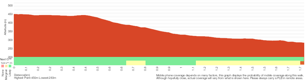
Analysis and summary of the altitude variation on the Clarinda Falls from Faulconbridge
Overview of this walks grade – based on the AS 2156.1 – 2001
Under this standard, a walk is graded based on the most difficult section of the walk.
| Length | 3.5 km | ||
| Time | 2 hrs | ||
| . | |||
| Grade 4/6 Hard track |
AS 2156.1 | Gradient | Very steep (4/6) |
| Quality of track | Formed track, with some branches and other obstacles (3/6) | ||
| Signs | Directional signs along the way (3/6) | ||
| Experience Required | No experience required (1/6) | ||
| Weather | Weather generally has little impact on safety (1/6) | ||
| Infrastructure | Limited facilities, not all cliffs are fenced (3/6) |
Some more details of this walks Grading
Here is a bit more details explaining grading looking at sections of the walk
Gradient
Around 1.3km of this walk is very steep, whilst the remaining 440m has short steep hills.
Quality of track
Around 1.3km of this walk follows a formed track, with some branches and other obstacles, whilst the remaining 410m follows a smooth and hardened path.
Signs
Around 1.7km of this walk is clearly signposted, whilst the remaining 25m has directional signs at most intersection.
Experience Required
This whole walk, 1.8km requires no previous bushwalking experience.
weather
This whole walk, 1.8km is not usually affected by severe weather events (that would unexpectedly impact safety and navigation).
Infrastructure
Around 1.7km of this walk is close to useful facilities (such as fenced cliffs and seats), whilst the remaining 25m has limited facilities (such as not all cliffs fenced).
Similar walks
A list of walks that share part of the track with the Clarinda Falls from Faulconbridge walk.
6.1 km One way
3 hrs
Hard track
11.5 km One way
5 hrs
Hard track
15.2 km One way
2 Days
Experienced only
23.4 km One way
2 Days
Experienced only
Other Nearby walks
A list of walks that start near the Clarinda Falls from Faulconbridge walk.
2.7 km Return
1 hr 30 mins
Hard track
13.5 km One way
6 hrs
Experienced only
9 km Return
4 hrs
Hard track
13.8 km Circuit
6 hrs 30 mins
Hard track
10.5 km Circuit
4 hrs 15 mins
Hard track
202 m Return
15 mins
Moderate track
180 m Return
15 mins
Moderate track
3.1 km Return
3 hrs 30 mins
Experienced only
1.2 km Return
1 hr 30 mins
Hard track
5.4 km Return
3 hrs 30 mins
Experienced only
15.9 km One way
7 hrs
Experienced only
8.6 km Return
3 hrs 30 mins
Hard track
Plan your trip to and from the walk here
The Clarinda Falls from Faulconbridge walk starts and ends at the Faulconbridge Station (gps: -33.69662, 150.53487)
Your transport options to Faulconbridge Station are by;
![]() Train. (get details)
Train. (get details)
![]() Bus. (get details)
Bus. (get details)
![]() Car. There is free parking available.
Car. There is free parking available.
(get details)
Short URL = http://wild.tl/ftcf
Gallery images
There are other downloads I am still working on.
You will probably need to login to access these — still all free.
* KML (google earth file)
* GPX (GPS file)
Special Maps/ brochures
* A3 topo maps
* PDF with Lands Topo map base
* PDF with arial image (and map overlay)
I wanted to get the main site live first, this extra stuff will come in time.
Happy walking
Matt 🙂
Faulconbridge to Springwood via Sassafras Gully

3 hrs
6.1 km One way
338 m
Hard track

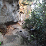
Faulconbridge
Faulconbridge, in the Blue Mountains, New South Wales, was named after the maiden name of Sir Henry Parkes’ mother. Faulconbridge sits on the Great Western Highway and is surrounded by valleys of lush bushland. This picturesque town was a home, and final resting place, for Sir Henry Parkes’, heralded as the ‘Father of Federation’. Faulconbridge was originally explored by non-indigenous Australians in 1813, by Blaxland, Wentworth and Lawson who were searching for a route over the Blue Mountains .
(0km) Faulconbridge Station → No. 10 Sir Henrys Pde
410 m
8 mins
10m
-16m
Moderate track
From the top of Faulconbridge Station, the walk heads off the station overpass to the bushland side of the station (if you come to a car park, you have gone to the wrong side of the station). The walk then keeps the rail line on the left as it follows the footpath down to the road. After a while, the walk comes to an intersection with Sir Henrys Pde, opposite house number 10.
Victory Track
The Victory Track is more formally know as the ‘Sir Henry Parkes Victory Track’[4] and is called the ‘Victoria Track’ in many guide books. The track starts near Sir Henry Parkes’ grave in Faulconbridge and leads to Sassafrass Gully Creek. Sir Henry Parks (1815-1896) was a politician and journalist, born in England. He is considered to be the ‘Father of Federation’ for Australia, although he died of natural causes 5 years before Australia’s federation. Parkes was the premier of New South Wales five times. The town Parkes was named in his honour. Parkes would sometime write under the pseudonym ‘Faulconbridge’ (his mothers maiden name) for the Sydney Morning Herald and other papers and Faulconbridge (the township) was named after his mother when Parkes purchased 600 acres in 1877. More info.
(0.41km) No. 10 Sir Henrys Pde → Int. Victory Trk and Clarinda Falls
1.3 km
38 mins
15m
-173m
Hard track
Turn right: From 10 Sir Henrys Pde (bushland side), the walk follows the ‘Victory Track’ sign down into the bush. The walk passes under a few rock overhangs and then crosses a creek. Passing a smaller track (on the left, which leads to the top of the falls), the walk soon comes down to a ‘Clarinda Falls’ sign[10].
(1.74km) Int. Victory Trk and Clarinda Falls → Clarinda Falls
30 m
1 mins
1m
-4m
Moderate track
Turn left: From the intersection, the track follows the ‘Clarinda Falls’ sign[11] towards the log fallen on the rock. The track tends left around the hillside, coming to Clarinda Falls. At the end of this side trip, retrace your steps back to the main walk then Continue straight.
Clarinda Falls
Clarinda Falls is a charming waterfall on Sassafras Creek. The water cascades over a near-vertical wall, into a sandy pool below. The falls are signposted from the main track and provide a nice cool detour, especially on warmer days. The falls are named for the first wife of Sir Henry Parkes, ‘Father of Australian Federation’.
(1.74km) Int. Victory Trk and Clarinda Falls → Victory Trk camping area
630 m
18 mins
23m
-72m
Hard track
Turn right: From the intersection, the walk follows the ‘Sassafras Gully’ sign[13] down the hill. The track keeps the creek on the left as it continues down the gully then crosses a creek junction. The walk meanders down the hillside and soon crosses a larger creek junction, before entering a campground clearing (beneath power lines).
Victory Track camping area
Victory Track camping area is a fairly large, informal camping place at the junction of Sassafras and Numantia Creeks. The clearing is in a moist section of forest with plenty of shade. Water from the creek should be treated before use.
(2.37km) Victory Trk camping area → Victory Trk pool
880 m
24 mins
61m
-78m
Moderate track
Continue straight: From the campground clearing, the walk follows the creek, keeping it to the left. The track winds up the hill and back down to the creek a few times and soon comes to an intersection with a faint track on the left (which leads to a pool in the creek).
Victory Track pool
The Victory Track pool is an unofficially-named pond in Sassafras Creek. The pond is deep in parts but not adequate for a swim. It does, however, offer a chance to rest and gaze over the water. There is a small sandy beach, some moss-covered rocks and a lovely grove of Sassafras trees around the pool. This is a nice spot to stop, catch your breath and soak up your surroundings.
(3.24km) Victory Trk pool → No. 18 Sassafras Gully Rd
1.7 km
39 mins
191m
-46m
Hard track
Continue straight: From the intersection, the walk heads down the valley, keeping the creek on the left. The walk soon turns left, crosses the creek and continues down the valley, with the creek now on the right. Leading down the valley, the track then crosses a gully to arrive at a blue ‘Faulconbridge Station’ sign (pointing back the way you came)[14].
Turn left: From the intersection, the walk follows the ‘Sassafras Gully Rd’ sign[15] up the stairs. The walk crosses a large creek junction and continues up the gully, passing under numerous rock overhangs. Moving away from the creek and its rocky outcrops, the walk steeply climbs the hillside. The walk comes below a rocky outcrop, which it follows around to the right, keeping the outcrop on the right (ignoring the track which leads up the outcrop). The walk comes to an unsignposted intersection with another track.
Turn right: From the intersection, the walk heads up the hill, keeping the rock outcrop to the right. The track tends left towards a house fenceline (house No. 18), which it follows to the end of Sassafras Gully Rd.
(4.92km) No. 18 Sassafras Gully Rd → Springwood Station
1.2 km
23 mins
38m
-35m
Very easy
Veer right: From the end of Sassafras Gully Rd, the walk heads to the top of the road and turns right onto Valley Rd. The walk follows the footpath on Valley Rd, passing Bee Farm Rd before turning left onto Homedale St. The walk continues along Homedale St then turns right onto Macquarie Rd. Macquarie Rd is followed to the train station, where the walk crosses the road using the pedestrian crossing.
Springwood
Springwood, along the Great Western Highway, is the second largest town in the Blue Mountains. Springwood also takes the title for the oldest railway station in the Blue Mountains. There are a variety of shops in Springwood, with quite a few cafes, bakeries and two historic hotels. Springwood was named by Governor Macquarie, when his wife and he stopped for water from a deep glen spring, in 1815. It seems aptly named, with many springs and creeks leading away from the ridge at Springwood, including Sassafras Gully, Magdala Creek and Glenbrook Creek. More info.
Maps for the Faulconbridge to Springwood via Sassafras Gully walk
You can download the PDF for this walk to print a map.
These maps below cover the walk and the wider area around the walk, they are worth carrying for safety reasons.
| Springwood | 1:25 000 Map Series | 90304S SPRINGWOOD | NSW-90304S |
| Penrith | 1:100 000 Map Series | 9030 PENRITH | 9030 |
Cross sectional view of the Faulconbridge to Springwood via Sassafras Gully bushwalking track
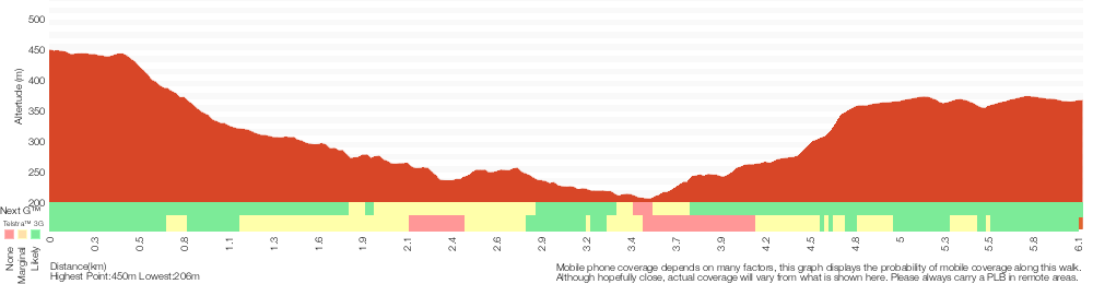
Analysis and summary of the altitude variation on the Faulconbridge to Springwood via Sassafras Gully

Overview of this walks grade – based on the AS 2156.1 – 2001
Under this standard, a walk is graded based on the most difficult section of the walk.
| Length | 6.1 km | ||
| Time | 3 hrs | ||
| . | |||
| Grade 4/6 Hard track |
AS 2156.1 | Gradient | Very steep (4/6) |
| Quality of track | Rough track, where fallen trees and other obstacles are likely (4/6) | ||
| Signs | Directional signs along the way (3/6) | ||
| Experience Required | No experience required (1/6) | ||
| Weather | Weather generally has little impact on safety (1/6) | ||
| Infrastructure | Limited facilities (such as cliffs not fenced, significant creeks not bridged) (4/6) |
Some more details of this walks Grading
Here is a bit more details explaining grading looking at sections of the walk
Gradient
3.6km of this walk has short steep hills and another 1.3km is very steep. The remaining (1.2km) is flat with no steps.
Quality of track
3.6km of this walk follows a formed track, with some branches and other obstacles and another 1.6km follows a smooth and hardened path. The remaining (900m) follows a rough track, where fallen trees and other obstacles are likely.
Signs
Around 3.1km of this walk has directional signs at most intersection, whilst the remaining 3km is clearly signposted.
Experience Required
This whole walk, 6km requires no previous bushwalking experience.
weather
This whole walk, 6km is not usually affected by severe weather events (that would unexpectedly impact safety and navigation).
Infrastructure
3km of this walk is close to useful facilities (such as fenced cliffs and seats) and another 2.2km has limited facilities (such as not all cliffs fenced). The remaining (900m) has limited facilities (such as cliffs not fenced, significant creeks not bridged).
Similar walks
A list of walks that share part of the track with the Faulconbridge to Springwood via Sassafras Gully walk.
3.5 km Return
2 hrs
Hard track
10.5 km Circuit
4 hrs 15 mins
Hard track
11.5 km One way
5 hrs
Hard track
13.8 km Circuit
6 hrs 30 mins
Hard track
15.2 km One way
2 Days
Experienced only
23.4 km One way
2 Days
Experienced only
Other Nearby walks
A list of walks that start near the Faulconbridge to Springwood via Sassafras Gully walk.
2.7 km Return
1 hr 30 mins
Hard track
13.5 km One way
6 hrs
Experienced only
9 km Return
4 hrs
Hard track
202 m Return
15 mins
Moderate track
180 m Return
15 mins
Moderate track
3.1 km Return
3 hrs 30 mins
Experienced only
1.2 km Return
1 hr 30 mins
Hard track
5.4 km Return
3 hrs 30 mins
Experienced only
15.9 km One way
7 hrs
Experienced only
8.6 km Return
3 hrs 30 mins
Hard track
18.3 km One way
7 hrs 15 mins
Experienced only
29.6 km One way
3 Days
Hard track
Plan your trip to and from the walk here
The Faulconbridge to Springwood via Sassafras Gully walk starts at the Faulconbridge Station (gps: -33.69662, 150.53487)
Your transport options to Faulconbridge Station are by;
![]() Train. (get details)
Train. (get details)
![]() Bus. (get details)
Bus. (get details)
![]() Car. There is free parking available.
Car. There is free parking available.
(get details)
![]() Train. (get details)
Train. (get details)
The Faulconbridge to Springwood via Sassafras Gully ends at the Springwood Station (gps: -33.699107, 150.5638)
Your transport options to Springwood Station are by;
![]() Bus. (get details)
Bus. (get details)
![]() Car. There is free parking available.
Car. There is free parking available.
(get details)
Short URL = http://wild.tl/ftsvsg
Gallery images
There are other downloads I am still working on.
You will probably need to login to access these — still all free.
* KML (google earth file)
* GPX (GPS file)
Special Maps/ brochures
* A3 topo maps
* PDF with Lands Topo map base
* PDF with arial image (and map overlay)
I wanted to get the main site live first, this extra stuff will come in time.
Happy walking
Matt 🙂
Comments