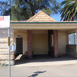
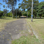
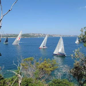
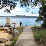
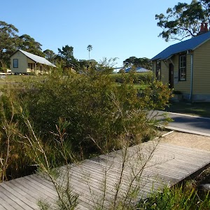
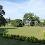
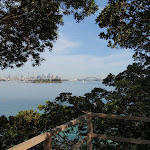
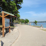
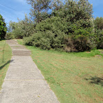
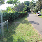
This short walk follows a set of sandstone steps from the narrow streets of Vaucluse to the small, isolated Queens Beach on Sydney Harbour. The beach has great views across the top of Rose Bay to the city and Sydney Harbour Bridge. A great place to wet the toes and enjoy a peaceful lunch by the water. Although the walk is short, the only flat section is on the beach.
Queens Beach
And Walk
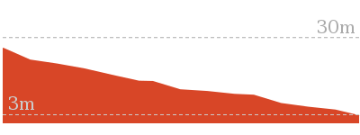
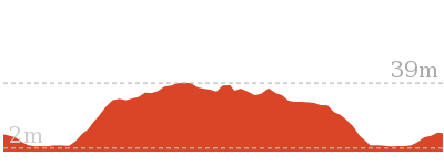
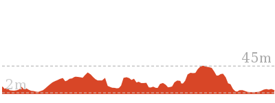
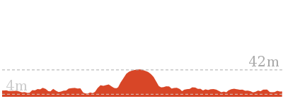
Queens Beach


10 mins
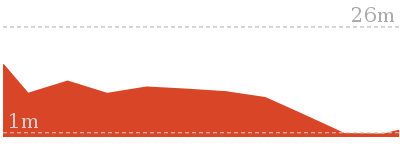
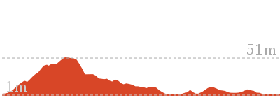
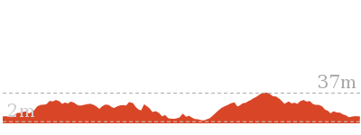
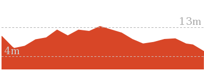
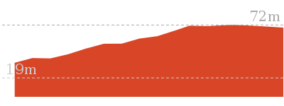
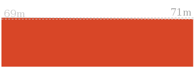
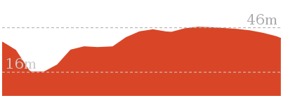
108 m Return

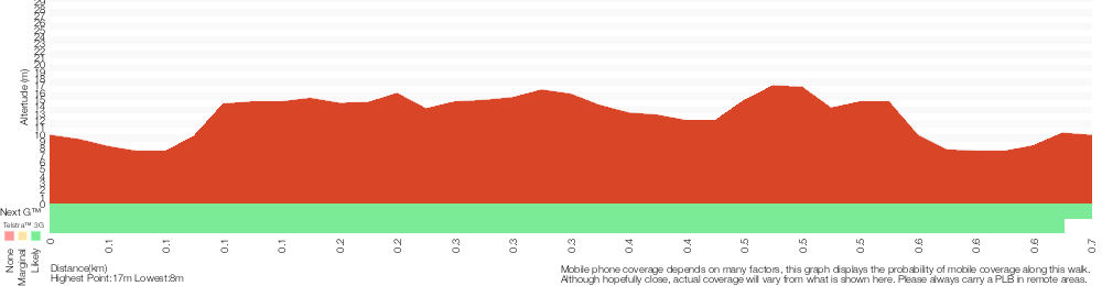
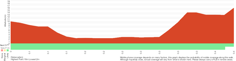
18 m
Moderate track


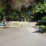
(0km) Int of Queens Ave and Little Queens Lane → Queens Beach

50 m
2 mins
0m
-18m
Moderate track
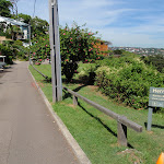
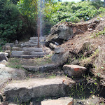
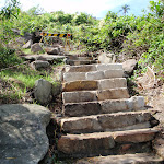
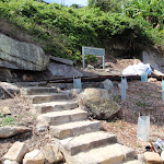
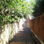
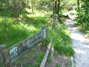
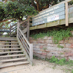
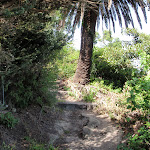
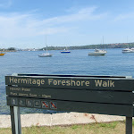
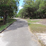
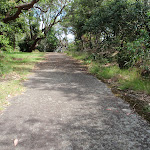
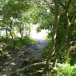
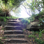
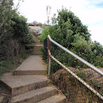
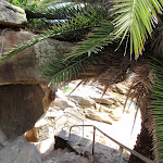
From the ‘Hermitage Foreshore Walk – Queens Beach’ sign[1] on Queens Ave (just near Little Queens Lane[2]), this walk heads down the sandstone steps towards the water. Partway down the steps (before the beach), this track comes to three-way intersection[3] with the main Hermitage Foreshore walking track.
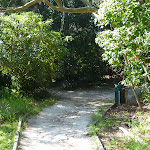
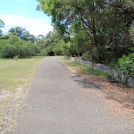
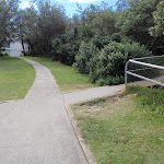
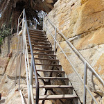
Veer left: From the intersection, this walk heads down the steps towards the beach. The track then comes to a boardwalk[4], a ‘Hermitage Foreshore Walk – Queens Beach’ sign[5] and a short set of steps leading down to the beach[6].
Veer left: From the intersection, this walk heads down the steps towards the beach. The track then comes to a boardwalk[4], a ‘Hermitage Foreshore Walk – Queens Beach’ sign[5] and a short set of steps leading down to the beach[6].
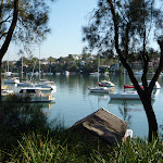
Queens Beach
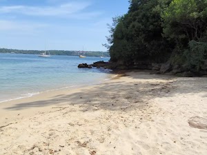
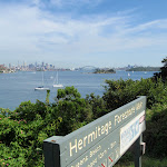
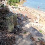
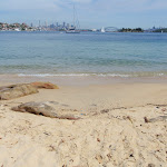
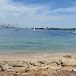
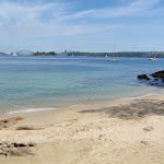
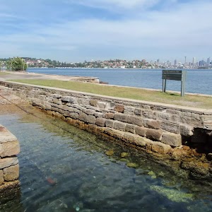
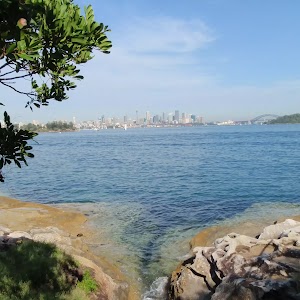
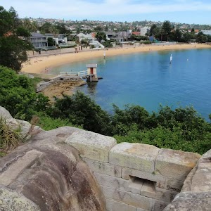
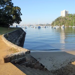
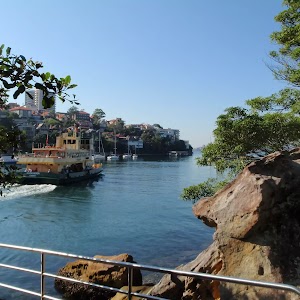
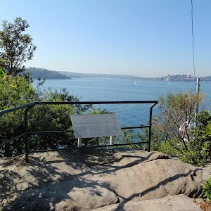
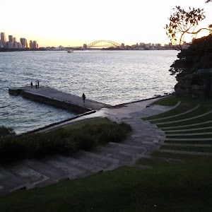
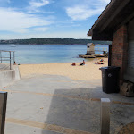
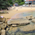
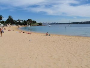
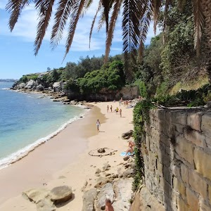
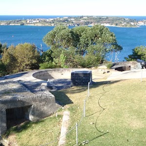
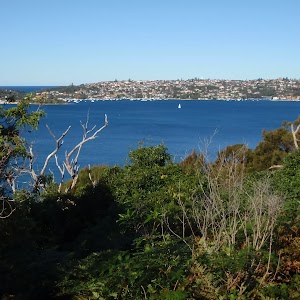
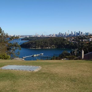
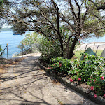
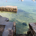
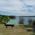
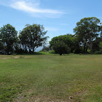
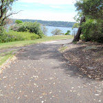
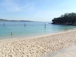
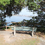
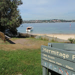
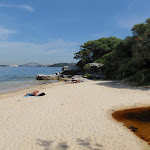
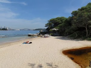
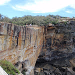
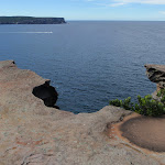
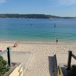
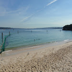
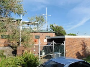
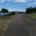
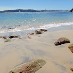
Queens Beach is a small, 50m wide sandy beach that faces west, near Queens Ave Vaucluse. The beach has the Hermitage Foreshore walk[7] running behind it. The beach is protected from the ocean surf and is not patrolled. There are great views across the harbour to the city and Harbour Bridge[8]. A quiet spot, providing an excuse to enjoy the view and splash the feet.
Maps for the Queens Beach walk
You can download the PDF for this walk to print a map.
These maps below cover the walk and the wider area around the walk, they are worth carrying for safety reasons.
| Sydney Heads | 1:25 000 Map Series | 91302N SYDNEY HEADS | NSW-91302N |
| Sydney | 1:100 000 Map Series | 9130 SYDNEY | 9130 |
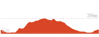
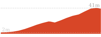
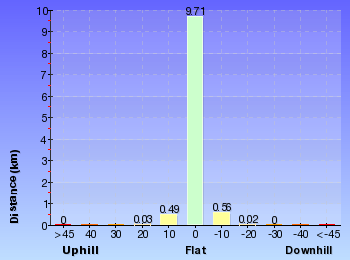
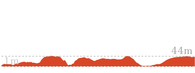
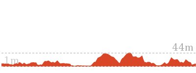
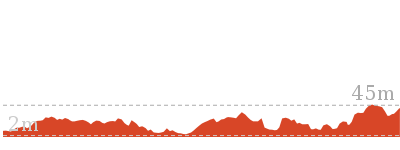
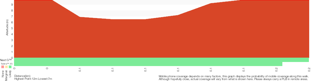
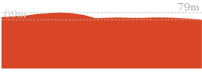
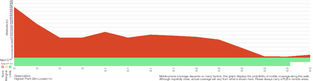
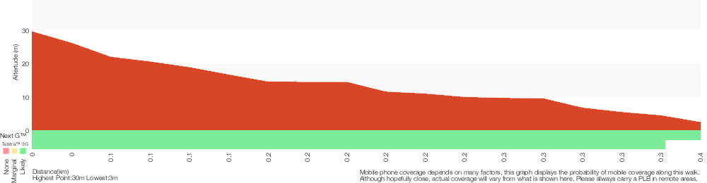
Cross sectional view of the Queens Beach bushwalking track
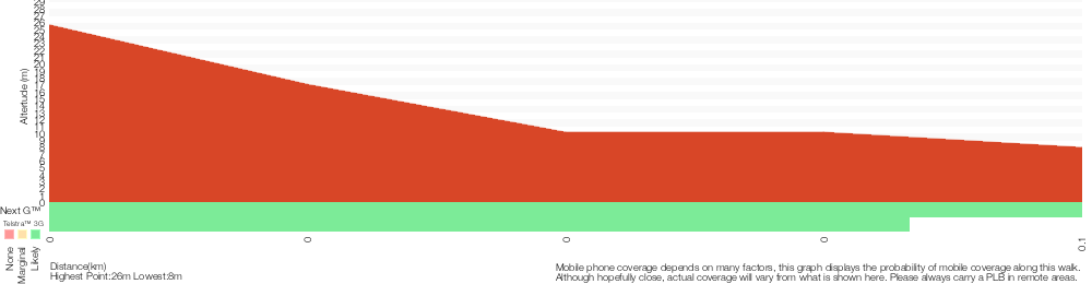
Analysis and summary of the altitude variation on the Queens Beach
Overview of this walks grade – based on the AS 2156.1 – 2001
Under this standard, a walk is graded based on the most difficult section of the walk.
| Length | 108 m | ||
| Time | 10 mins | ||
| . | |||
| Grade 3/6 Moderate track |
AS 2156.1 | Gradient | Short steep hills (3/6) |
| Quality of track | Clear and well formed track or trail (2/6) | ||
| Signs | Clearly signposted (1/6) | ||
| Experience Required | No experience required (1/6) | ||
| Weather | Weather generally has little impact on safety (1/6) | ||
| Infrastructure | Generally useful facilities (such as fenced cliffs and seats) (1/6) |
Some more details of this walks Grading
Here is a bit more details explaining grading looking at sections of the walk
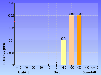
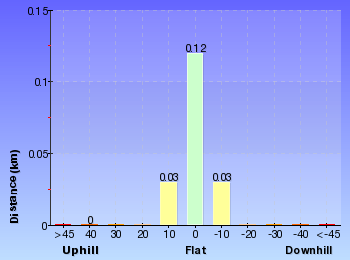
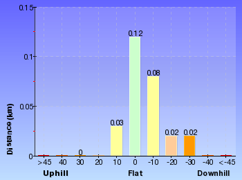
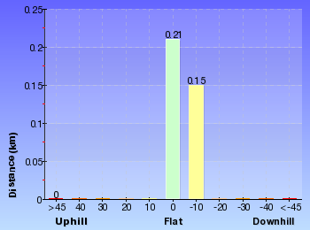
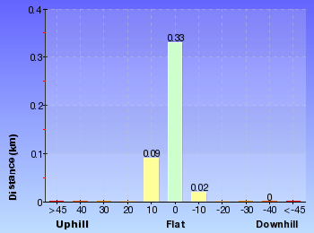
Gradient
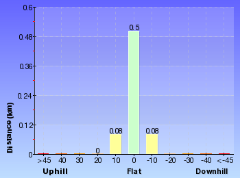
This whole walk, 55m has short steep hills.
Quality of track
Around 40m of this walk follows a smooth and hardened path, whilst the remaining 15m follows a clear and well formed track or trail.
Signs
This whole walk, 55m is clearly signposted.
Experience Required
This whole walk, 55m requires no previous bushwalking experience.
weather
This whole walk, 55m is not usually affected by severe weather events (that would unexpectedly impact safety and navigation).
Infrastructure
This whole walk, 55m is close to useful facilities (such as fenced cliffs and seats).
Similar walks
A list of walks that share part of the track with the Queens Beach walk.
552 m Return
20 mins
Moderate track
2.2 km One way
1 Hr
Moderate track
Other Nearby walks
A list of walks that start near the Queens Beach walk.

706 m Return
25 mins
Easy track
896 m Return
20 mins
Easy track
1.7 km Circuit
40 mins
Easy track
2.5 km Circuit
1 Hr
Moderate track
1.8 km Circuit
40 mins
Easy track

661 m Circuit
15 mins
Easy track

1.7 km Circuit
1 Hr
Moderate track
2.8 km One way
1 hr 30 mins
Moderate track
2.8 km Return
1 hr 15 mins
Easy track
886 m Return
30 mins
Hard track
4.1 km Circuit
1 hr 45 mins
Hard track
2.5 km Circuit
1 Hr
Hard track
Plan your trip to and from the walk here
The Queens Beach walk starts and ends at the Int of Queens Ave and Little Queens Lane (gps: -33.860857, 151.26951)
Your transport options to Int of Queens Ave and Little Queens Lane are by;
![]() Bus. (get details)
Bus. (get details)
![]() Car. There is free parking available.
Car. There is free parking available.
(get details)


Short URL = http://wild.tl/qb
Gallery images
There are other downloads I am still working on.
You will probably need to login to access these — still all free.
* KML (google earth file)
* GPX (GPS file)
Special Maps/ brochures
* A3 topo maps
* PDF with Lands Topo map base
* PDF with arial image (and map overlay)
I wanted to get the main site live first, this extra stuff will come in time.
Happy walking
Matt 🙂
Sydney to Boronia Park
And Walk
Sydney to Boronia Park

2 hrs 30 mins
6 km One way
176 m
Moderate track
This walk is the southern most stretch of the Great North Walk and spends much of the time exploring the scenic and historic urban areas around Woolwich and Hunters Hill. Starting at the birth place of modern Sydney you soon enjoy a ferry ride across the world renowned harbour, passing the Opera House and heading under the Harbour Bridge. Once on dry land again you will explore the streets and some lovely pockets of remnant bushland of this peninsula. There are a few chances to stop at a cafe along the way before coming to open area at Boronia Park.


The Obelisk
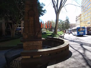
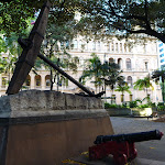
The Obelisk in Macquarie Place (Cnr of Bridge and Loftus Sts) is the original Mile Stone for 19th century roads in NSW. The surrounding park is the original town square built in 1810, while the Obelisk was erected by Governor Macquarie (well actually the Convicts did the heavy work) in 1818. For nearly 200 years this monument stood as the zero mile/km marker for all principal roads. There are a number of inscriptions including distance markers and “The Obelisk was erected in Macquarie Place A.D.1818, to Record that all the Public Roads Leading to the Interior of the Colony are measured from it. L.Macquarie Esq Governor”. The park has a number of other historic items worth exploring.
(0km) The Obelisk → Circular Quay
260 m
4 mins
1m
-5m
Very easy
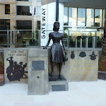
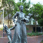
From the tall sandstone obelisk[1][2][3] (in Macquarie Place[4][5] at the intersection of Bridge and Loftus Sts, Sydney), this walk heads down along the footpath beside Loftus St[6], towards the view of the Harbour Bridge. After about 80m, the footpath leads past ‘Jessie Street Gardens’[7], which is ‘Dedicated to the achievements of Australian women’[8] – definitely worth the time to read the plaques[9][10][11].
From here, the walk continues down past McDonald’s[12] and across Alfred St to underneath the ‘Circular Quay Railway Station’ building[13].
From here, the walk continues down past McDonald’s[12] and across Alfred St to underneath the ‘Circular Quay Railway Station’ building[13].
Circular Quay

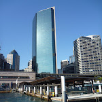
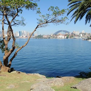
Where the harbour meets the city, Circular Quay is a transport hub joining the busy ferry wharf with the train and bus services. The Quay provides great views of the Harbour Bridge[14], Opera House and several other popular sights of Sydney. There are many small food kiosks[15] and cafes as well as a McDonalds[16]. Circular Quay is the site of Australia’s first colonial settlement. In 1794, Thomas Muir was transported to Australia and later bought a farm and built a cottage on what we now call Circular Quay. Not a great deal is known about the traditional owners, as in 1789 almost half of this indigenous population died during a smallpox epidemic. It is reported that only three Cadigal people were left by 1791. In 1879, there were some Aboriginal people living in the boat sheds (near the now Museum of Contemporary Art) when they were dispossessed of that space so it could be used for hosting an international exhibition. Now, Circular Quay is popular among visitors enjoying the sites, and also daily commuters.
(0.26km) Circular Quay → Woolwich Ferry Wharf, Valentia St
4.8 km
20 mins
2m
-2m
Very easy
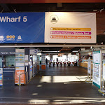
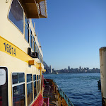
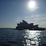
Continue straight: From Circular Quay ferry terminal[21], this walk heads over to Wharf 5[22] and catches a ferry (about $6) to Woolwich Ferry Wharf, Valentia St[23][24]. A ferry leaves every 30-60 mins during the day. The trip is very pleasant and passes the Opera House[25], travels the under the Harbour Bridge[26], around Garden Island[27], near Cockatoo Island[28] and on to Woolwich Ferry Wharf near the mouth of the Lane Cove River.
Woolwich Wharf

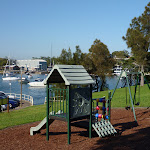
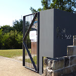
Woolwich Wharf, found at the end of Valentia Street, is a bit of a transport hub with a ferry terminal and a popular bus stop. There are public toilets in the bus shelter area[29], a public phone box and across the road is an open grass area and kids’ playground in ‘Valentia Street Reserve’[30]. There is also a large sign highlighting the Great North Walk’s presence[31].
(5.07km) Woolwich Ferry Wharf, Valentia St → Goat Paddock
720 m
13 mins
23m
-6m
Very easy
Continue straight: From Woolwich Wharf[32] (at the end of Valentia Street[33]), this walk follows the footpath, past the toilets[34] and the large ‘Great North Walk’ sign[35] (and past the children’s playground[36] which is across the road) to the top of ‘Valentia St’[37]. The walk turns left and follows the tree-lined ‘The Point Rd’[38], which bends left and becomes ‘Gale St’[39]. Not far along Gale St, this walk comes to the front of the gates at the top of the signposted ‘Goat Paddock’ park[40][41] (on your left)
Goat Paddock

Goat Paddock is the open area north of Woolwich Dock. The park has a path winding down through the middle[42], providing access to the waters edge. In 1835, the Clarke family received a grant of the land at the eastern end of the peninsula, what we now call Woolwich. In 1898, Morts Dock and Engineering Company bought this land and commissioned the excavation of the dock. The area is well maintained and is used by many locals for their morning strolls.
(5.8km) Goat Paddock → Woolwich Lookout
80 m
1 mins
1m
-2m
Easy track
Continue straight: From the gates at the top of ‘Goat Paddock’[44][45], this walk follows the footpath uphill beside Gale St, which soon bends right. The walk passes ‘Woolwich Pier Hotel’[46] (on the opposite side of the road), then veers left across the grass on the signposted ‘Woolwich Lookout’ park[47], and soon comes to the fenced[48] lookout platform[49] on the left, about 80m from the lookout.
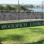
Woolwich Lookout
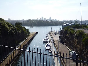
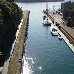
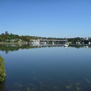
Woolwich Lookout is a fenced lookout[50] atop of the cliffs at the western end of Woolwich Dock[51]. There are great views down the sandstone cutting[52], through the dock at the mouth of the Lane Cove River and to North Sydney. In December 1901, the W. Solomon & Sons company (commissioned by Morts Dock and Engineering Company) completed the excavation of 85,000 cubic metres of sandstone to construct this dry dock. At the time, this 188 metres long, and 27 metres wide, pit was the largest dry dock in Australia. In 1963, the Army purchased the site and now it is managed by the Sydney Harbour Federation Trust.
(5.87km) Woolwich Lookout → Top of Kellys Bush
590 m
13 mins
35m
-11m
Easy track
Continue straight: From ‘Woolwich Lookout’[54], this walk winds down the concrete footpath[55], initially keeping the water view to your left. Crossing the road[56], this walk then follows the GNW arrow post[57] downhill along Edgecliff Rd[58][59], which soon bends right (enjoying the water views across to Cockatoo Island[60]), then crosses Margaret St[61] to become Alfred St. Continuing to the end of Alfred St[62], this walk comes to a short sandstone wall and a ‘Kellys Bush’ sign[63]
Continue straight: From the end of Alfred St[64], this walk follows the ‘Nelson Parade’ sign[65] up the sandstone steps[66]. At the top of the steps, this walk turns right, following the ‘Picnic Area’ sign[67] along the dirt track[68] for about 80m to a three-way intersection just past a bench seat[69]. This walk veers right, following the ‘Nelson Parade’ sign[70] up the steps[71], passing a ‘Kellys bush’ information sign[72] at the top of the hill, then leaves the park through a gap in the timber fence[73] to come to a road[74] beside Weil Park[75] (a large playing field[76]).
Continue straight: From the end of Alfred St[64], this walk follows the ‘Nelson Parade’ sign[65] up the sandstone steps[66]. At the top of the steps, this walk turns right, following the ‘Picnic Area’ sign[67] along the dirt track[68] for about 80m to a three-way intersection just past a bench seat[69]. This walk veers right, following the ‘Nelson Parade’ sign[70] up the steps[71], passing a ‘Kellys bush’ information sign[72] at the top of the hill, then leaves the park through a gap in the timber fence[73] to come to a road[74] beside Weil Park[75] (a large playing field[76]).
Kellys Bush
In the late 1880s, pocket of bushland between Prince George Parade and Alfred St, Woolwich was set aside to to act as a buffer zone between the Parramatta River and the Sydney Smelting Company. The area was named after the owner of the land and smelting company, T.H. Kelly [77]. From the passion of the local people who fought to protect this area, Kelly’s Bush is now owned by the Hunters Hill Council and cared for by a team of local bush regenerators[78].
(6.46km) Top of Kellys Bush → Int of Brookes and Vernon Sts
830 m
17 mins
27m
-46m
Moderate track
Continue straight: From the top of Kellys Bush, this walk follows the GNW arrow[79] gently uphill along Prince George Parade[80] (directly away from the park). Soon after passing a set of swings[81] (on the central reservation), this walk turns right[82] (crossing over the other part Prince George Parade) to follow another GNW arrow post along ‘Gladstone Ave’[83] until coming to an intersection with ‘Woolwich Rd’[84].
Turn left: From the intersection, this walk follows the GNW arrow west alongside Woolwich Rd[85] for about 100m, then turns right across the road[86] and heads to the end of Serpentine Rd[87]. There are some GNW arrows here and a footpath[88] on the left.
Continue straight: From the end of Serpentine Rd[89], this walk follows the GNW arrows down a few steps[90], then downhill along the footpath[91]. The path soon leads down to Vernon St to turn left[92], following the street for about 30m. Here the walk turns right[93], leading down a pedestrian lane-way[94] and steps[95][96] between two house, coming to ‘Mornington Reserve’, beside Alexandra Bay on the Lane Cove River[97][98]. Here the walk turns left, leading up along the grassy track reserve behind some houses[99] for about 180m to turn left at a GNW post[100] marking another pedestrian lane-way. The walk heads up this lane-way[101] then up the steps to turn right on Vernon St[102], coming almost immediately to an intersection with Brookes St[103] (on your right).
(7.29km) Int of Brookes and Vernon Sts → Hunters Hill Shops
1.2 km
22 mins
31m
-24m
Easy track
Continue straight: From the intersection, this walk heads uphill along Vernon St[104] which soon bends left. At the top of the hill, this walk turns right to follow the footpath beside Woolwich Rd[105] for about 150m, then turns right down Futuna Lane[106]. At the T-intersection, this walk turns left to follow Futuna St past the grand ‘St. Peter Chanel Catholic Church’ building[107] and then come to another T-intersection[109]. Here the walk crosses Crescent St and turns right a short distance and then left into Garrick Ave[110]. At the end of Garrick Ave[111], this walk follows the GNW arrow along the zigzagging pedestrian lane way[112][113] for about 170m to come to Passy Ave[114]. Here the walk crosses the road and turns right, following the footpath for about 150m to then turn left onto Ambrose St[115]. After a further 100m, the walk turns right at Ferry St to pass in front of the large sandstone ‘All Saints Anglican Church’ building[116]. Just past this church, the walk passes a few shops[118] to cross Alexandra St, then turns left. Just after crossing Ady St, this walk comes to to ‘Jaspers Restaurant’[119], opposite more cafes and shops[121][122].
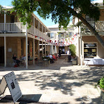
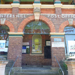
Hunters Hill Shops
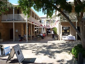
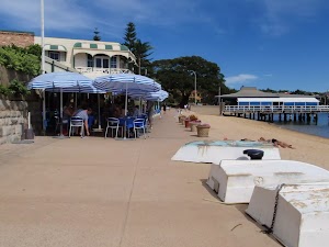
Just opposite the intersection of Alexandra and Ady Streets is a community shopping village in Hunters Hill. There are a few cafes and small restaurants[123] set among a lovely series of sandstone buildings[124]. You could even get your hair cut if so desired. The Ricciotti Deli Cafe open 7 days 0800-1700 (weekends 0800-1500) ph: (02) 9817-7388.[126]
(8.5km) Hunters Hill Shops → Joubert Street Reserve
1.4 km
26 mins
32m
-45m
Easy track
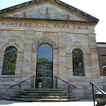
Continue straight: From in front of ‘Jaspers Restaurant’[127], this walk heads gently downhill along Alexandra St[129] almost immediately passing ‘Vienna’ Cottage[130][131] (an artisan’s home built in 1871). This walk continues along beside Alexandra St[133] for about 500m, passing the post office[134], Masonic Centre[135], town hall[136], Congregational Church[137], a tiny and very old-looking pharmacy[138] to come to a four-way intersection with Mount St[139] (on your right), opposite a children’s playground[140]. Here the walk follows the GNW post right[141] and downhill along Mount St[142] to come to a waterfront[143] intersection[144] at the end of the street.
Turn left : From the northern end of Mount St[145], this walk follows the asphalt footpath[146] behind Hunters Hill High School[147], whilst keeping the Lane Cover River[148] to your right. The path leads past a few information signs[149][150], then bends left at the grassy clearing[151] to head up the side of the school. The path leads up a small set of stairs[152] and turns right on Reiby Rd, where the walk follows the road[153] for 100m until the road bends right. Here, the walk crosses the road[154] to follow the GNW arrow[155] up to the right and along the concrete footpath, which leads under under Burns Bay Rd (Fig Tree Bridge)[156]. Just after passing under the bridge, the walk heads left, diagonally up through Joubert Street Reserve to Joubert St[157] (just downhill from the intersection with Figtree Rd).
Turn left : From the northern end of Mount St[145], this walk follows the asphalt footpath[146] behind Hunters Hill High School[147], whilst keeping the Lane Cover River[148] to your right. The path leads past a few information signs[149][150], then bends left at the grassy clearing[151] to head up the side of the school. The path leads up a small set of stairs[152] and turns right on Reiby Rd, where the walk follows the road[153] for 100m until the road bends right. Here, the walk crosses the road[154] to follow the GNW arrow[155] up to the right and along the concrete footpath, which leads under under Burns Bay Rd (Fig Tree Bridge)[156]. Just after passing under the bridge, the walk heads left, diagonally up through Joubert Street Reserve to Joubert St[157] (just downhill from the intersection with Figtree Rd).
(9.89km) Joubert Street Reserve → Boronia Park
930 m
17 mins
26m
-3m
Very easy
Continue straight: From Joubert Street Reserve, this walk crosses Joubert St and heads uphill to then turn right into Figtree Rd. The walk leads along the footpath beside Figtree Rd[158] for about 350m, then turns right onto Ryde Rd[159] (there is a Coles Express service station to your left[160], if you want a cold drink). Following the footpath alongside Ryde Rd for about 500m (passing St Joseph’s College[161] along the way), this walk comes to Boronia Ave, just beside Boronia Park[162].
Boronia Park

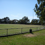
Boronia Park is found at the intersection of Ryde Rd and Boronia Ave[163]. The park is centered around a couple of large playing fields[164] and a grand stand[165]. Here you will find public toilets[166], tap water, electric BBQs[167] and a children’s playground[168]. There is also shade from the trees and rain shelter to provide some relief on the hot or wet days.
Maps for the Sydney to Boronia Park walk
You can download the PDF for this walk to print a map.
These maps below cover the walk and the wider area around the walk, they are worth carrying for safety reasons.
| Parramatta River | 1:25 000 Map Series | 91303N PARRAMATTA RIVER | NSW-91303N |
| Sydney | 1:100 000 Map Series | 9130 SYDNEY | 9130 |
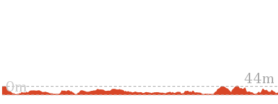
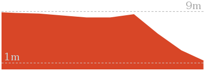
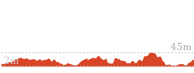
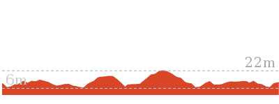
Cross sectional view of the Sydney to Boronia Park bushwalking track

Analysis and summary of the altitude variation on the Sydney to Boronia Park
Overview of this walks grade – based on the AS 2156.1 – 2001
Under this standard, a walk is graded based on the most difficult section of the walk.
| Length | 6 km | ||
| Time | 2 hrs 30 mins | ||
| . | |||
| Grade 3/6 Moderate track |
AS 2156.1 | Gradient | Gentle hills with occasional steps (2/6) |
| Quality of track | Formed track, with some branches and other obstacles (3/6) | ||
| Signs | Directional signs along the way (3/6) | ||
| Experience Required | No experience required (1/6) | ||
| Weather | Weather generally has little impact on safety (1/6) | ||
| Infrastructure | Generally useful facilities (such as fenced cliffs and seats) (1/6) |
Some more details of this walks Grading
Here is a bit more details explaining grading looking at sections of the walk
Gradient
Around 8km of this walk is flat with no steps, whilst the remaining 2.4km has gentle hills with occasional steps.
Quality of track
8km of this walk follows a smooth and hardened path and another 2.5km follows a clear and well formed track or trail. The remaining (420m) follows a formed track, with some branches and other obstacles.
Signs
Around 10km of this walk is clearly signposted, whilst the remaining 420m has directional signs at most intersection.
Experience Required
This whole walk, 11km requires no previous bushwalking experience.
weather
This whole walk, 11km is not usually affected by severe weather events (that would unexpectedly impact safety and navigation).
Infrastructure
This whole walk, 11km is close to useful facilities (such as fenced cliffs and seats).
Similar walks
A list of walks that share part of the track with the Sydney to Boronia Park walk.
5.8 km One way
2 hrs
Moderate track

33 km One way
2 Days
Hard track


44.4 km One way
3 Days
Hard track

Other Nearby walks
A list of walks that start near the Sydney to Boronia Park walk.
9.8 km One way
4 hrs
Moderate track
2.7 km Circuit
1 hr 15 mins
Easy track
2 km One way
45 mins
Easy track
4.2 km One way
1 hr 45 mins
Moderate track
478 m Return
15 mins
Easy track
2.8 km One way
1 hr 30 mins
Moderate track
1.7 km Circuit
1 Hr
Moderate track

108 m Return
10 mins
Moderate track
552 m Return
20 mins
Moderate track
3.7 km One way
1 hr 45 mins
Moderate track
4.4 km One way
2 hrs
Moderate track
3 km Circuit
1 hr 30 mins
Moderate track
Plan your trip to and from the walk here
The Sydney to Boronia Park walk starts at the The Obelisk (gps: -33.863268, 151.21023)
Your transport options to The Obelisk are by;
![]() Ferry. (get details)
Ferry. (get details)
![]() Train. (get details)
Train. (get details)
![]() Bus. (get details)
Bus. (get details)
![]() Car. Parking fees apply in the area.
Car. Parking fees apply in the area.
(get details)
The Sydney to Boronia Park ends at the Boronia Park (gps: -33.827196, 151.13814)
Your transport options to Boronia Park are by;
![]() Bus. (get details)
Bus. (get details)
![]() Car. There is free parking available.
Car. There is free parking available.
(get details)
Short URL = http://wild.tl/stbp
Gallery images
There are other downloads I am still working on.
You will probably need to login to access these — still all free.
* KML (google earth file)
* GPX (GPS file)
Special Maps/ brochures
* A3 topo maps
* PDF with Lands Topo map base
* PDF with arial image (and map overlay)
I wanted to get the main site live first, this extra stuff will come in time.
Happy walking
Matt 🙂
Camp Cove Cannon
And Walk
Camp Cove Cannon

15 mins
358 m Return
14 m
Easy track
Spend some time relaxing and exploring Camp Cove – the first landing place for Europeans in Australia. On this walk, you will head across the northern end of Camp Cove Beach, up some steps to follow an old sandstone cobbled road. This road leads to a great vantage point, with views over the Sydney Harbour to the city. This spot is also host to a large (disused) gun, that once defended these shores. Plenty of history and beauty.


(0km) Camp Cove car park → Camp Cove Beach
50 m
1 mins
0m
-4m
Easy track
From the signposted ‘Camp Cove Car Park[1], this walk follows the ‘No Through Road’ sign[2] to the end of ‘Cliff St’. The footpath leads past a ‘Camp Cove timeline’ information sign[3] then, at the end of the road, turns left, coming to the front of the kiosk[4] at the northern end of Camp Cove Beach[5].
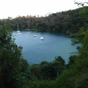
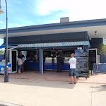
Camp Cove
Camp Cove is home to a lovely, yellow sand, north-east facing beach. The cove is on the protected side of South Head and is a popular spot for swimming and relaxing on the beach. At the northern end of the beach is a kiosk[6], toilet block[7] and an entrance to Sydney Harbour National Park[8].
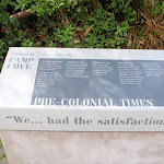
The cove was an important location to the Cadigal (Gadigal) people who gathered fresh water, shellfish, launched their canoes and buried some of their people nearby.
This cove is also believed to be the first landing place for Europeans in 1788. The name Camp Cove was given during that landing and appears on the earliest maps of Sydney Harbour[11].
(0.05km) Camp Cove Beach → Cannon
130 m
3 mins
7m
-3m
Easy track
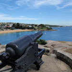
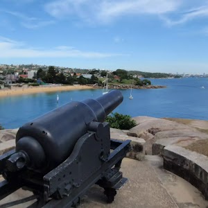
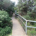
Veer right: From the front of Camp Cove Beach kiosk[12], this walk crosses the beach (keeping the water to your left)[13] and climbs up the timber staircase[14]. From the intersection at the top of the stairs, this walk continues straight, along the timber boardwalk[15] that soon turns into a concrete path. The path soon comes to a wide, cobbled sandstone path[16] that leads up a disused cannon[17], gun emplacement and great harbour views[18].
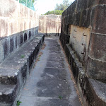
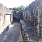
Cannon
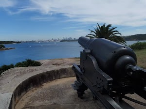
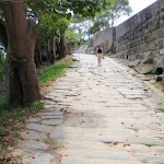
This cannon was placed here prior to 1890, along with the rest of this gun emplacement and rifle walls. The emplacement was designed to protect a military jetty and boat shed from the threat of an invasion. The ‘Cobblestone Road’ beside the cannon was built during the late 1870s or early 1880s and extends from the jetty in Camp Cove up to Hornby Road above. The road was build to carry supplies and ordnance from Camp Cove to the various military installations on south head. More info.
Maps for the Camp Cove Cannon walk
You can download the PDF for this walk to print a map.
These maps below cover the walk and the wider area around the walk, they are worth carrying for safety reasons.
| Sydney Heads | 1:25 000 Map Series | 91302N SYDNEY HEADS | NSW-91302N |
| Sydney | 1:100 000 Map Series | 9130 SYDNEY | 9130 |
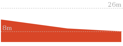
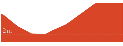
Cross sectional view of the Camp Cove Cannon bushwalking track
Analysis and summary of the altitude variation on the Camp Cove Cannon
Overview of this walks grade – based on the AS 2156.1 – 2001
Under this standard, a walk is graded based on the most difficult section of the walk.
| Length | 358 m | ||
| Time | 15 mins | ||
| . | |||
| Grade 2/6 Easy track |
AS 2156.1 | Gradient | Gentle hills with occasional steps (2/6) |
| Quality of track | Clear and well formed track or trail (2/6) | ||
| Signs | Clearly signposted (1/6) | ||
| Experience Required | No experience required (1/6) | ||
| Weather | Weather generally has little impact on safety (1/6) | ||
| Infrastructure | Generally useful facilities (such as fenced cliffs and seats) (1/6) |
Some more details of this walks Grading
Here is a bit more details explaining grading looking at sections of the walk
Gradient
Around 130m of this walk has gentle hills with occasional steps, whilst the remaining 55m is flat with no steps.
Quality of track
Around 130m of this walk follows a smooth and hardened path, whilst the remaining 55m follows a clear and well formed track or trail.
Signs
This whole walk, 180m is clearly signposted.
Experience Required
This whole walk, 180m requires no previous bushwalking experience.
weather
This whole walk, 180m is not usually affected by severe weather events (that would unexpectedly impact safety and navigation).
Infrastructure
This whole walk, 180m is close to useful facilities (such as fenced cliffs and seats).
Similar walks
A list of walks that share part of the track with the Camp Cove Cannon walk.
992 m Return
30 mins
Moderate track

1.7 km Circuit
45 mins
Easy track
2.5 km Circuit
1 Hr
Hard track
2.8 km Return
1 hr 15 mins
Easy track
4.1 km Circuit
1 hr 45 mins
Hard track
Other Nearby walks
A list of walks that start near the Camp Cove Cannon walk.

243 m Circuit
15 mins
Easy track
886 m Return
30 mins
Hard track
842 m Return
30 mins
Moderate track
4.9 km Circuit
2 hrs 30 mins
Moderate track
144 m Return
7 mins
Very easy
1.7 km Return
1 Hr
Moderate track
904 m Return
30 mins
Easy track
2.2 km One way
1 Hr
Moderate track
896 m Return
20 mins
Easy track
1.7 km Circuit
40 mins
Easy track
2.5 km Circuit
1 Hr
Moderate track
1.8 km Circuit
40 mins
Easy track
Plan your trip to and from the walk here
The Camp Cove Cannon walk starts and ends at the Camp Cove car park (gps: -33.83939, 151.27997)
Your transport options to Camp Cove car park are by;
![]() Bus. (get details)
Bus. (get details)
![]() Car. There is free parking available.
Car. There is free parking available.
(get details)
Short URL = http://wild.tl/ccc
Gallery images
There are other downloads I am still working on.
You will probably need to login to access these — still all free.
* KML (google earth file)
* GPX (GPS file)
Special Maps/ brochures
* A3 topo maps
* PDF with Lands Topo map base
* PDF with arial image (and map overlay)
I wanted to get the main site live first, this extra stuff will come in time.
Happy walking
Matt 🙂
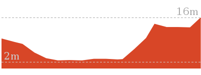
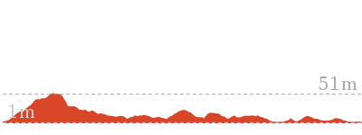
Queens Beach to Hermit Point
And Walk
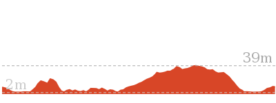
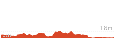
Queens Beach to Hermit Point

20 mins
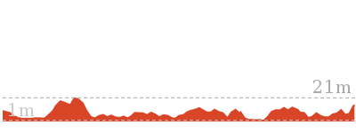
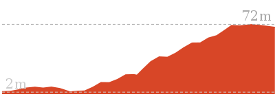
552 m Return
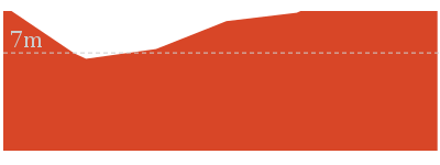
39 m
Moderate track
This short walk explores a memorable section of the Hermitage Foreshore Walk. Starting from Queens Ave, this walk heads down the fairly steep stone steps and enjoys a short side trip to Queens Beach. From the beach, this walk heads back up the steps a short way, then follows the main walk around to Hermit Point. Hermit Point is a great place for a picnic and to enjoy the water views. There is access to the water, natural shade, and picnic tables. A short walk with great harbour views.


(0km) Int of Queens Ave and Little Queens Lane → Bottom of Queens Rd Track
40 m
2 mins
0m
-16m
Moderate track
From the ‘Hermitage Foreshore Walk – Queens Beach’ sign[1] on Queens Ave (just near Little Queens Lane[2]), this walk heads down the sandstone steps towards the water. Partway down the steps (before the beach), this track comes to three-way intersection[3] with the main Hermitage Foreshore walking track.
(0.04km) Bottom of Queens Rd Track → Queens Beach
10 m
0m
-2m
Moderate track
Veer left: From the intersection, this walk heads down the steps towards the beach. The track then comes to a boardwalk[4], a ‘Hermitage Foreshore Walk – Queens Beach’ sign[5] and a short set of steps leading down to the beach[6]. At the end of this side trip, retrace your steps back to the main walk then Veer left.
Queens Beach
Queens Beach is a small, 50m wide sandy beach that faces west, near Queens Ave Vaucluse. The beach has the Hermitage Foreshore walk[7] running behind it. The beach is protected from the ocean surf and is not patrolled. There are great views across the harbour to the city and Harbour Bridge[8]. A quiet spot, providing an excuse to enjoy the view and splash the feet.
(0.04km) Bottom of Queens Rd Track → Hermit Point
240 m
5 mins
7m
-16m
Easy track
Turn right: From the intersection, this walk heads along the short flat path[9] (keeping the water down to your left) and soon heads up some steps[10]. The track crosses a small creek[11] and then leads behind some houses. Next, the walk heads down some steps and turns left, following a wide concrete path[12] down the hill to the signposted ‘Hermit Point’[13].
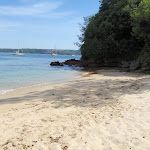
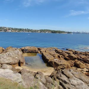
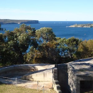
Hermit Point
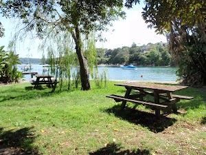
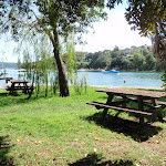
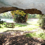
Hermit Point hosts a grassy open area and is surrounded by a sandstone sea wall[14]. The sea wall has been shaped to host some boat pens[15], a launch[16] and a timber wharf[17]. The area is now protected as part of the Sydney Harbour National Park. Here, you will find a number of picnic tables[18], a small sandstone cave[19], natural shade and some great water views[20]. The headland, bay and ultimately the Hermitage Foreshore Walk, derive their names from the large home behind this point. The Hermitage was originally built in 1840 by Alexander Dick, then in the 1870’s, Edward Mason Hunt undertook some significant renovations, turning it into a Victorian Rustic Gothic house.
Maps for the Queens Beach to Hermit Point walk
You can download the PDF for this walk to print a map.
These maps below cover the walk and the wider area around the walk, they are worth carrying for safety reasons.
| Sydney Heads | 1:25 000 Map Series | 91302N SYDNEY HEADS | NSW-91302N |
| Sydney | 1:100 000 Map Series | 9130 SYDNEY | 9130 |
Cross sectional view of the Queens Beach to Hermit Point bushwalking track
Analysis and summary of the altitude variation on the Queens Beach to Hermit Point
Overview of this walks grade – based on the AS 2156.1 – 2001
Under this standard, a walk is graded based on the most difficult section of the walk.
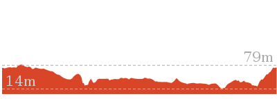
| Length | 552 m | ||
| Time | 20 mins | ||
| . | |||
| Grade 3/6 Moderate track |
AS 2156.1 | Gradient | Short steep hills (3/6) |
| Quality of track | Clear and well formed track or trail (2/6) | ||
| Signs | Clearly signposted (1/6) | ||
| Experience Required | No experience required (1/6) | ||
| Weather | Weather generally has little impact on safety (1/6) | ||
| Infrastructure | Generally useful facilities (such as fenced cliffs and seats) (1/6) |
Some more details of this walks Grading
Here is a bit more details explaining grading looking at sections of the walk
Gradient
Around 240m of this walk has gentle hills with occasional steps, whilst the remaining 40m has short steep hills.
Quality of track
Around 240m of this walk follows a clear and well formed track or trail, whilst the remaining 40m follows a smooth and hardened path.
Signs
This whole walk, 280m is clearly signposted.
Experience Required
This whole walk, 280m requires no previous bushwalking experience.
weather
This whole walk, 280m is not usually affected by severe weather events (that would unexpectedly impact safety and navigation).
Infrastructure
This whole walk, 280m is close to useful facilities (such as fenced cliffs and seats).
Similar walks
A list of walks that share part of the track with the Queens Beach to Hermit Point walk.
108 m Return
10 mins
Moderate track
2.2 km One way
1 Hr
Moderate track
Other Nearby walks
A list of walks that start near the Queens Beach to Hermit Point walk.
706 m Return
25 mins
Easy track
896 m Return
20 mins
Easy track
1.7 km Circuit
40 mins
Easy track
2.5 km Circuit
1 Hr
Moderate track
1.8 km Circuit
40 mins
Easy track
661 m Circuit
15 mins
Easy track
1.7 km Circuit
1 Hr
Moderate track
2.8 km One way
1 hr 30 mins
Moderate track
2.8 km Return
1 hr 15 mins
Easy track
886 m Return
30 mins
Hard track
4.1 km Circuit
1 hr 45 mins
Hard track
2.5 km Circuit
1 Hr
Hard track
Plan your trip to and from the walk here
The Queens Beach to Hermit Point walk starts and ends at the Int of Queens Ave and Little Queens Lane (gps: -33.860857, 151.26951)
Your main transport option to Int of Queens Ave and Little Queens Lane is by;
![]() Bus. (get details)
Bus. (get details)
Important Note: There is no car transport option to the start of this walk.
Short URL = http://wild.tl/qbthp
Gallery images
There are other downloads I am still working on.
You will probably need to login to access these — still all free.
* KML (google earth file)
* GPX (GPS file)
Special Maps/ brochures
* A3 topo maps
* PDF with Lands Topo map base
* PDF with arial image (and map overlay)
I wanted to get the main site live first, this extra stuff will come in time.
Happy walking
Matt 🙂
Shakespheres Point loop
And Walk
Shakespheres Point loop

15 mins
661 m Circuit
24 m
Easy track
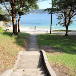
On this short walk, you will follow a series of footpaths to Shark Bay and head up some sandstone steps to the great views of Shakespheres Point. Since you are up on this headland, it is worth doing a loop around before heading back down to the main area of Nielsen Park. Make a day of it by staying for a swim and a bite to eat.


(0km) Greycliffe Ave Car Park → Mid Nielsen Park Int
70 m
1 mins
0m
-2m
Very easy
From the lower end of the car park on Greycliffe Ave, this walk heads around the gate and along the sealed path (driveway) towards the water, passing the ‘Sydney Harbour National Park’ sign[1]. After ≈50m, the path leads to a four-way intersection just past the garbage bins.
(0.07km) Mid Nielsen Park Int → Nielsen Park Cafe
130 m
2 mins
0m
-5m
Very easy
Continue straight: From the intersection, this walk heads towards the water following the wide path[2]. The path soon bends left (near the toilet block, on the right[3]) and heads behind the beach, past the large information sign[4]. Soon the path heads over the ‘Dressing Pavilion’ tunnel[5] and, ≈50m later, comes to the front of the Nielsen Park Cafe[6] with it’s great water views[7]. At the end of this side trip, retrace your steps back to the main walk then Turn left.
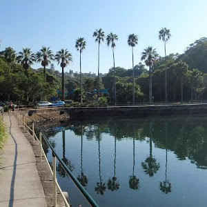
Shark Bay
Located at the northern end of Nielsen Park, this beach faces north across Sydney Harbour. The sandy beach offers a swimming net enclosure[8], public toilets[9][10] and change rooms[11], showers[12] and is a popular place for people to simply relax. The beach is a focal point of Nielsen Park and also boasts a cafe[13]. Protected by the harbour, there is no surf at this beach. The beach is not patrolled. This is a lovely spot, with natural shade not far from the beach.
Nielsen Park Cafe
Open 8-5 daily, this historic cafe offers inside seating and a range of meals, including breakfast, sandwiches and hot food. This is one of a number of buildings in Nielsen Park which are available for functions. For further enquiries, contact 9337 1574. More info.
(0.07km) Mid Nielsen Park Int → Shakespheres Point int
50 m
1 mins
7m
0m
Easy track
Turn right: From the intersection, this walk heads along the path, past the bins and towards the staircase[14](keeping the water to your left). The walk heads up the sandstone staircase, passing the female toilet block[15] along the way, to a three-way intersection[16] near a grassy clearing and Shakespheres Point[17].
(0.12km) Shakespheres Point int → Bottle and Glass Clearing
140 m
3 mins
5m
-5m
Very easy
Veer left: From the intersection, this walk follows the sealed path around the side of the hill, keeping the water and grassy clearing to your left[18]. Soon the path leads through a grove of trees and past a group of garbage bins[19] before coming to another grassy clearing with some bench seats[20] and views – this is Bottle and Glass clearing.
(0.26km) Bottle and Glass Clearing → Roundabout gate
170 m
3 mins
4m
-6m
Very easy
Continue straight: From the clearing[21], this walk heads away from the garbage bins, following the sealed path as it bends right[22] (keeping the water to your left). The path heads gently downhill[23] past the back of some houses[24] and comes to an intersection and locked gate[25] (near the intersection of Greycliffe Ave and Coolong Rd).
(0.44km) Roundabout gate → Greycliffe Ave Car Park
230 m
4 mins
8m
-10m
Easy track
Turn right: From the intersection, this walk heads up the steeper path away from the gate (initially keeping the ‘Sydney Harbour National Park – Nielsen Park’ sign[26] to your right). The path heads up a short, but moderately steep section[27] and soon flattens out, wandering through a grassy clearing[28]. As the path comes into view of the water, it leads to a three-way intersection[29] (with steps on the left) just before Shakespheres Point[30].
Turn left : From the intersection, this walk heads down the stairs. The steps lead past the female toilet block[31] and continues down to the open parkland area of Nielsen Park. The walk continues past the bin to a four-way intersection[32].
Turn left: From the intersection, this walk follows the wide sealed path (driveway) directly away from the water, past the garbage bins. The path soon leads past the ‘Sydney Harbour National Park’ sign[33] and through the gate to Greycliff Ave.
Maps for the Shakespheres Point loop walk
You can download the PDF for this walk to print a map.
These maps below cover the walk and the wider area around the walk, they are worth carrying for safety reasons.
| Sydney Heads | 1:25 000 Map Series | 91302N SYDNEY HEADS | NSW-91302N |
| Sydney | 1:100 000 Map Series | 9130 SYDNEY | 9130 |
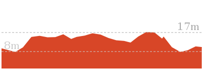
Cross sectional view of the Shakespheres Point loop bushwalking track
Analysis and summary of the altitude variation on the Shakespheres Point loop
Overview of this walks grade – based on the AS 2156.1 – 2001
Under this standard, a walk is graded based on the most difficult section of the walk.
| Length | 661 m | ||
| Time | 15 mins | ||
| . | |||
| Grade 2/6 Easy track |
AS 2156.1 | Gradient | Gentle hills with occasional steps (2/6) |
| Quality of track | Smooth and hardened path (1/6) | ||
| Signs | Clearly signposted (1/6) | ||
| Experience Required | No experience required (1/6) | ||
| Weather | Weather generally has little impact on safety (1/6) | ||
| Infrastructure | Generally useful facilities (such as fenced cliffs and seats) (1/6) |
Some more details of this walks Grading
Here is a bit more details explaining grading looking at sections of the walk
Gradient
Around 450m of this walk is flat with no steps, whilst the remaining 210m has gentle hills with occasional steps.
Quality of track
This whole walk, 660m follows a smooth and hardened path.
Signs
This whole walk, 660m is clearly signposted.
Experience Required
This whole walk, 660m requires no previous bushwalking experience.
weather
This whole walk, 660m is not usually affected by severe weather events (that would unexpectedly impact safety and navigation).
Infrastructure
This whole walk, 660m is close to useful facilities (such as fenced cliffs and seats).
Similar walks
A list of walks that share part of the track with the Shakespheres Point loop walk.
896 m Return
20 mins
Easy track
1.7 km Circuit
40 mins
Easy track
1.8 km Circuit
40 mins
Easy track
2.2 km One way
1 Hr
Moderate track
2.5 km Circuit
1 Hr
Moderate track
Other Nearby walks
A list of walks that start near the Shakespheres Point loop walk.
706 m Return
25 mins
Easy track
108 m Return
10 mins
Moderate track
552 m Return
20 mins
Moderate track
1.7 km Circuit
1 Hr
Moderate track
2.8 km One way
1 hr 30 mins
Moderate track
2.8 km Return
1 hr 15 mins
Easy track
886 m Return
30 mins
Hard track
4.1 km Circuit
1 hr 45 mins
Hard track
2.5 km Circuit
1 Hr
Hard track
243 m Circuit
15 mins
Easy track
548 m Circuit
20 mins
Moderate track
358 m Return
15 mins
Easy track
Plan your trip to and from the walk here
The Shakespheres Point loop walk starts and ends at the Greycliffe Ave Car Park (gps: -33.850846, 151.26857)
Your transport options to Greycliffe Ave Car Park are by;
![]() Bus. (get details)
Bus. (get details)
![]() Car. There is free parking available.
Car. There is free parking available.
(get details)
Short URL = http://wild.tl/spl
Gallery images
There are other downloads I am still working on.
You will probably need to login to access these — still all free.
* KML (google earth file)
* GPX (GPS file)
Special Maps/ brochures
* A3 topo maps
* PDF with Lands Topo map base
* PDF with arial image (and map overlay)
I wanted to get the main site live first, this extra stuff will come in time.
Happy walking
Matt 🙂
Strickland House and Milk Beach
And Walk
Strickland House and Milk Beach

25 mins
706 m Return
31 m
Easy track
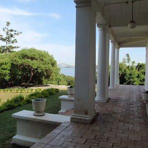
Starting from Vaucluse Rd, you will head down past the stately Strickland House to the small but lovely Milk Beach on Sydney Harbour. There are several interesting buildings in the Strickland House complex as well as some interesting open exotic gardens to explore. From behind Strickland House, you will then turn right and head along a short section of the Hermitage Foreshore Walk down to Milk Beach, where you will find more great harbour and city views.


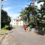


(0km) Top of Strickland House Driveway → Strickland House
160 m
3 mins
0m
-15m
Very easy
From beside Vaucluse Rd (number 52), this walk heads through the gates[1] (only open 9-5 daily) and follows the Strickland House driveway downhill[3]. The driveway soon leads past a caretaker’s cottage[4] (on your left) and then bends left. This walk ignores the side tracks, soon coming to the front of the main grand, white Strickland House building[5].
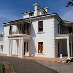
Strickland House
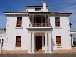
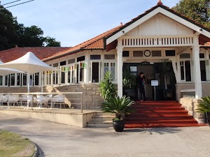
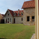
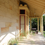
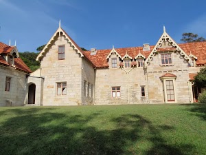
First established in 1913 and named after Sir Gerald Strickland (Governor of NSW 1913-1917), Strickland House was a women’s convalescent home until 1989. Today, the house and gardens are hired out for private functions, however, if just walking through, this is a great spot to take a break, enjoy the views and rest from the walk. For more information, phone Strickland House on (02) 9337 5999.
(0.16km) Strickland House → Strickland House picnic area
90 m
2 mins
0m
-5m
Easy track
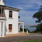
Turn right: From the front of Strickland House[8], this walk heads around the back of the house towards the water view[9], keeping the house to your left[10]. After enjoying the building, this walk heads across the back lawn[11] to the line of trees, where there are a few picnic tables[12] and an intersection with the Hermitage Foreshore Walk.
(0.26km) Strickland House picnic area → Milk Beach
100 m
2 mins
2m
-9m
Easy track
Turn right: From Strickland House picnic area, this walk follows the NPWS arrow through a small grove of trees (keeping the water to your left). The track soon leads down some stairs[13], then turns left to find a bench seat[14] and a large ‘Hermitage Foreshore Walk’ sign[15] behind Milk Beach. From here, the walk heads down the hill and onto Milk Beach[16].
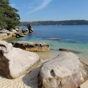
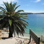
Milk Beach
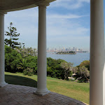
Milk Beach is a small, secluded, sandy beach in Sydney Harbour National Park, on the inside of South Head. In the ‘back yard’ of Strickland House[17], this beach is a memorable spot along the Hermitage Foreshore Walk[18]. The beach is about 50m wide and faces south-east. The views across the water to the city and to Shark Island are great[19]. A seat on the grassy clearing behind the beach makes a very inviting offer to sit[20] and enjoy for a while. This is also a great place to get the toes wet.
Maps for the Strickland House and Milk Beach walk
You can download the PDF for this walk to print a map.
These maps below cover the walk and the wider area around the walk, they are worth carrying for safety reasons.
| Sydney Heads | 1:25 000 Map Series | 91302N SYDNEY HEADS | NSW-91302N |
| Sydney | 1:100 000 Map Series | 9130 SYDNEY | 9130 |
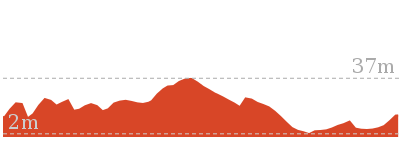
Cross sectional view of the Strickland House and Milk Beach bushwalking track
Analysis and summary of the altitude variation on the Strickland House and Milk Beach
Overview of this walks grade – based on the AS 2156.1 – 2001
Under this standard, a walk is graded based on the most difficult section of the walk.
| Length | 706 m | ||
| Time | 25 mins | ||
| . | |||
| Grade 2/6 Easy track |
AS 2156.1 | Gradient | Gentle hills with occasional steps (2/6) |
| Quality of track | Clear and well formed track or trail (2/6) | ||
| Signs | Clearly signposted (1/6) | ||
| Experience Required | No experience required (1/6) | ||
| Weather | Weather generally has little impact on safety (1/6) | ||
| Infrastructure | Generally useful facilities (such as fenced cliffs and seats) (1/6) |
Some more details of this walks Grading
Here is a bit more details explaining grading looking at sections of the walk
Gradient
Around 190m of this walk has gentle hills with occasional steps, whilst the remaining 160m is flat with no steps.
Quality of track
Around 190m of this walk follows a clear and well formed track or trail, whilst the remaining 160m follows a smooth and hardened path.
Signs
This whole walk, 350m is clearly signposted.
Experience Required
This whole walk, 350m requires no previous bushwalking experience.
weather
This whole walk, 350m is not usually affected by severe weather events (that would unexpectedly impact safety and navigation).
Infrastructure
This whole walk, 350m is close to useful facilities (such as fenced cliffs and seats).
Similar walks
A list of walks that share part of the track with the Strickland House and Milk Beach walk.
2.2 km One way
1 Hr
Moderate track
2.5 km Circuit
1 Hr
Moderate track
Other Nearby walks
A list of walks that start near the Strickland House and Milk Beach walk.
896 m Return
20 mins
Easy track
1.7 km Circuit
40 mins
Easy track
1.8 km Circuit
40 mins
Easy track
661 m Circuit
15 mins
Easy track
108 m Return
10 mins
Moderate track
552 m Return
20 mins
Moderate track
1.7 km Circuit
1 Hr
Moderate track
2.8 km One way
1 hr 30 mins
Moderate track
2.8 km Return
1 hr 15 mins
Easy track
886 m Return
30 mins
Hard track
4.1 km Circuit
1 hr 45 mins
Hard track
2.5 km Circuit
1 Hr
Hard track
Plan your trip to and from the walk here
The Strickland House and Milk Beach walk starts and ends at the Top of Strickland House Driveway (gps: -33.85509, 151.26864)
Your transport options to Top of Strickland House Driveway are by;
![]() Bus. (get details)
Bus. (get details)
![]() Car. There is free parking available.
Car. There is free parking available.
(get details)
Short URL = http://wild.tl/shamb
Gallery images
There are other downloads I am still working on.
You will probably need to login to access these — still all free.
* KML (google earth file)
* GPX (GPS file)
Special Maps/ brochures
* A3 topo maps
* PDF with Lands Topo map base
* PDF with arial image (and map overlay)
I wanted to get the main site live first, this extra stuff will come in time.
Happy walking
Matt 🙂
Gap Bluff Lookout
And Walk
Gap Bluff Lookout

30 mins
886 m Return
43 m
Hard track
This walk explores the coastal cliffs near The Gap on Sydney’s South Head. The main focal point for this walk is the view from the rocky bluff. The cliff makes for very spectacular scenery and the views extend from North Head along the coast, and even peer across the harbour to the city. This walk starts from Watsons Bay and follows a well used footpath all the way. There is much history in the area and the couple of side trips described in this walk open up some more places to explore.


Watsons Bay
Watsons Bay is a popular spot to enjoy the harbour, Robertson Park and some fish and chips. Doyles offers a formal dining restaurant[1] and the more relaxed fish and chip shop[2] on the ferry wharf[3]. Robertson Park is a large open grassy park with some natural shade[4], a rotunda[5], toilets[6][7], children’s play equipment[8], garbage bins[9] and picnic tables[10]. More info.
(0km) Watsons Bay Wharf → The bottom of the Gap steps
230 m
5 mins
17m
0m
Very easy
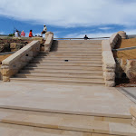
From Watsons Bay Wharf[11], this walk heads diagonally across the turning circle at the end of Military Rd[12] and into ‘Robertson Park’[13]. The walk follows the path diagonally across the open park and tends a little left (straight ahead) at the four-way intersection beside the rotunda[14]. Here the walk goes up the ramp[15] and crosses Military Rd using the crossing[16], coming to the base of the steps (that lead to The Gap)[17].
(0.23km) The bottom of the Gap steps → The Gap
20 m
0m
-2m
Very easy
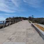
The Gap

The Gap is one of Sydney’s most famous ocean cliff lookouts. The view from the track beside the stretch of cliff is simply stunning[22]. The tall cliffs are enhanced by the rock platform and the pounding ocean far below[23]. Sadly, this site is not only known for the natural wonder, but also for the many deaths that occur here each year. Security cameras[26] and an emergency phone[27] have been installed, to help assist people considering suicide. On the unlikely event that you see someone in distress, please call the police on 000 and lifeline on 131 114, or use the nearby emergency phone. More info.
(0.25km) The Gap → The Gap Bluff Centre Int
100 m
3 mins
13m
0m
Easy track
Turn left: From The Gap[28], this walk heads up the hill along the path, keeping the fence and water views to your right. The path leads past the ‘Sydney Harbour National Park – Gap Bluff’ sign[29] and more great views of The Gap. The path comes to a three-way intersection in a small clearing, marked with a few signs including ‘The Gap timeline’[30].
(0.35km) The Gap Bluff Centre Int → The Gap Bluff Centre (Officers Mess)
90 m
2 mins
3m
-8m
Very easy
Continue straight: From the intersection, this walk heads towards the large white building along the narrow, flat path[31], away from the ocean views. The path soon leads to a car park[32], where the walk turns left[33], around to the front of The Gap Bluff Centre (Officers’ Mess) building[34]. At the end of this side trip, retrace your steps back to the main walk then Turn left.
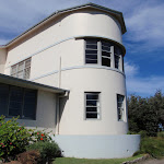
The Gap Bluff Centre (Officers Mess)

The Gap Bluff Centre, once know as the Officers’ Mess, is a large white building just north-east of The Gap on South Head. This building was once part of the South Head School of Artillery. Now part of Sydney Harbour National Park, this building is hired out for functions and conferences. Built in 1936[35], the curved building has since been extended. The building is surrounded by a car parking area and an exotic garden.
(0.35km) The Gap Bluff Centre Int → The Gap Bluff Lookout
90 m
2 mins
10m
-1m
Hard track
Turn right: From the intersection, this walk heads up the path then steps[36], following the fence and keeping the water views to your right. The path leads past several information signs on local plant life[37][38][39][40] and some lovely wildflowers[41]. The walk continues up the many steps[42] to a rocky clearing[43] near the top. Here the walk tends left and takes the steps through the cleft in the rock to find another rocky clearing and lookout with great panoramic views at the top of Gap Bluff[44].
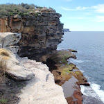
The Gap Bluff Lookout

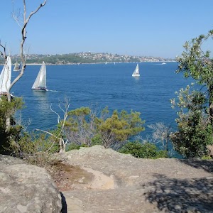
The Gap Bluff Lookout sits high on the rocky hill overlooking the South Pacific Ocean. On the left is a view to North Head[45] and to your right, looking south down the coast, there are great views over The Gap[46]. There are also distant views over the harbour to the city[47]. This site is significant to the traditional owners, the Birrabirragal people, who once occupied the area – although not at this site, there are some rock engraving still remaining[48]. This is a great place to visit and well worth climbing the steps for the view.
(0.44km) The Gap Bluff Lookout → Gun Emplacement Lookout
150 m
4 mins
10m
-16m
Very easy
Turn left: From the Gap Bluff Lookout, this walk follows the footpath away from the gap[49] and into the heath[50], keeping the ocean to your right. This path soon leads to a three-way intersection (at an old car park undergoing regeneration[51][52]) marked with a ‘Banksia integrifolia – coast banksia’ information sign[53].
Veer right: From the intersection, this walk heads uphill along the sealed footpath, away from the face of the ‘Banksia integrifolia – coast banksia’ information sign[54]. Soon the path passes a lookout on your right[55] and comes to a old gun emplacement marked with a ‘The gunnery range’ sign[56] and a short track to a fenced lookout with another sign[57]. At the end of this side trip, retrace your steps back to the main walk then Turn sharp left.
Veer right: From the intersection, this walk heads uphill along the sealed footpath, away from the face of the ‘Banksia integrifolia – coast banksia’ information sign[54]. Soon the path passes a lookout on your right[55] and comes to a old gun emplacement marked with a ‘The gunnery range’ sign[56] and a short track to a fenced lookout with another sign[57]. At the end of this side trip, retrace your steps back to the main walk then Turn sharp left.

Maps for the Gap Bluff Lookout walk
You can download the PDF for this walk to print a map.
These maps below cover the walk and the wider area around the walk, they are worth carrying for safety reasons.
| Sydney Heads | 1:25 000 Map Series | 91302N SYDNEY HEADS | NSW-91302N |
| Sydney | 1:100 000 Map Series | 9130 SYDNEY | 9130 |
Cross sectional view of the Gap Bluff Lookout bushwalking track
Analysis and summary of the altitude variation on the Gap Bluff Lookout
Overview of this walks grade – based on the AS 2156.1 – 2001
Under this standard, a walk is graded based on the most difficult section of the walk.
| Length | 886 m | ||
| Time | 30 mins | ||
| . | |||
| Grade 4/6 Hard track |
AS 2156.1 | Gradient | Very steep (4/6) |
| Quality of track | Clear and well formed track or trail (2/6) | ||
| Signs | Clearly signposted (1/6) | ||
| Experience Required | No experience required (1/6) | ||
| Weather | Weather generally has little impact on safety (1/6) | ||
| Infrastructure | Generally useful facilities (such as fenced cliffs and seats) (1/6) |
Some more details of this walks Grading
Here is a bit more details explaining grading looking at sections of the walk
Gradient
250m of this walk is flat with no steps and another 100m has gentle hills with occasional steps. The remaining (90m) is very steep.
Quality of track
Around 350m of this walk follows a smooth and hardened path, whilst the remaining 90m follows a clear and well formed track or trail.
Signs
This whole walk, 440m is clearly signposted.
Experience Required
This whole walk, 440m requires no previous bushwalking experience.
weather
This whole walk, 440m is not usually affected by severe weather events (that would unexpectedly impact safety and navigation).
Infrastructure
This whole walk, 440m is close to useful facilities (such as fenced cliffs and seats).
Similar walks
A list of walks that share part of the track with the Gap Bluff Lookout walk.
2.5 km Circuit
1 Hr
Hard track
4.1 km Circuit
1 hr 45 mins
Hard track
Other Nearby walks
A list of walks that start near the Gap Bluff Lookout walk.
2.8 km Return
1 hr 15 mins
Easy track
243 m Circuit
15 mins
Easy track
358 m Return
15 mins
Easy track
992 m Return
30 mins
Moderate track
1.7 km Circuit
45 mins
Easy track
2.2 km One way
1 Hr
Moderate track
896 m Return
20 mins
Easy track
1.7 km Circuit
40 mins
Easy track
2.5 km Circuit
1 Hr
Moderate track
1.8 km Circuit
40 mins
Easy track
661 m Circuit
15 mins
Easy track
548 m Circuit
20 mins
Moderate track
Plan your trip to and from the walk here
The Gap Bluff Lookout walk starts and ends at the Watsons Bay Wharf (gps: -33.843316, 151.28184)
Your transport options to Watsons Bay Wharf are by;
![]() Ferry. (get details)
Ferry. (get details)
![]() Bus. (get details)
Bus. (get details)
![]() Car. There is free parking available.
Car. There is free parking available.
(get details)
Short URL = http://wild.tl/gbl
Gallery images
There are other downloads I am still working on.
You will probably need to login to access these — still all free.
* KML (google earth file)
* GPX (GPS file)
Special Maps/ brochures
* A3 topo maps
* PDF with Lands Topo map base
* PDF with arial image (and map overlay)
I wanted to get the main site live first, this extra stuff will come in time.
Happy walking
Matt 🙂
History of Nielsen Park
And Walk
History of Nielsen Park

20 mins
896 m Return
25 m
Easy track
On this short walk, you will follow the footpaths through Nielsen Park, visiting some of the historic buildings. Walking past the beautiful Shark Bay, you may be temped to take a dip or at least stop and enjoy the blue water and sandstone boulders. Climbing up the stairs, you will then be able to explore the historic Steele Point Gun Emplacement and Greycliffe House before wandering back down to Shark Bay where you can grab a drink from the kiosk.


(0km) Greycliffe Ave Car Park → Nielsen Park Cafe
200 m
3 mins
0m
-7m
Very easy
From the lower end of the car park on Greycliffe Ave, this walk heads around the gate and along the sealed path (driveway) towards the water, passing the ‘Sydney Harbour National Park’ sign[1]. After ≈50m, the path leads to a four-way intersection just past the garbage bins.
Continue straight: From the intersection, this walk heads towards the water following the wide path[2]. The path soon bends left (near the toilet block, on the right[3]) and heads behind the beach, past the large information sign[4]. Soon the path heads over the ‘Dressing Pavilion’ tunnel[5] and, ≈50m later, comes to the front of the Nielsen Park Cafe[6] with it’s great water views[7].
Continue straight: From the intersection, this walk heads towards the water following the wide path[2]. The path soon bends left (near the toilet block, on the right[3]) and heads behind the beach, past the large information sign[4]. Soon the path heads over the ‘Dressing Pavilion’ tunnel[5] and, ≈50m later, comes to the front of the Nielsen Park Cafe[6] with it’s great water views[7].
Shark Bay
Located at the northern end of Nielsen Park, this beach faces north across Sydney Harbour. The sandy beach offers a swimming net enclosure[8], public toilets[9][10] and change rooms[11], showers[12] and is a popular place for people to simply relax. The beach is a focal point of Nielsen Park and also boasts a cafe[13]. Protected by the harbour, there is no surf at this beach. The beach is not patrolled. This is a lovely spot, with natural shade not far from the beach.
Nielsen Park Cafe
Open 8-5 daily, this historic cafe offers inside seating and a range of meals, including breakfast, sandwiches and hot food. This is one of a number of buildings in Nielsen Park which are available for functions. For further enquiries, contact 9337 1574. More info.
(0.2km) Nielsen Park Cafe → Western end of Shark Bay
90 m
1 mins
1m
0m
Very easy
Continue straight: From Nielsen Park Cafe, this walk heads the short distance along the path in front of the cafe and behind the beach (keeping the water to your right)[14]. The path heads past the ‘William Albert Notting’[15] and ‘Niels R.W. Nielsen, MLA’[16] memorial[17] (on your left) to soon find a four-way intersection (at the base of some steps) at the eastern end of Shark Bay[18].
(0.28km) Western end of Shark Bay → Degaussing range
70 m
2 mins
11m
0m
Easy track
Continue straight: From the intersection, this walk follows the ‘Hermitage Foreshore Walking Track’ sign[19] up the stairs. The path soon flattens out though the open grassy area, and heads up a few more steps to come to an intersection with a road (driveway) next to the fenced degaussing range (on your right)[20].
Degaussing range
This degaussing range, found at Steele Point, was constructed in 1960 and is still operated by the Royal Australian Navy today. Degaussing is the process of removing (or at least reducing) a magnetic field. This degaussing range services four areas in the harbour (about 500m from the building), where metal ships passing over will be automatically de-magnetised. Why? Mostly to prevent the triggering of seabed mines. More info.
(0.35km) Degaussing range → Steele Point Gun Emplacement
50 m
1 mins
0m
-7m
Easy track
Turn sharp right: From the intersection, this walk heads up the driveway, keeping the degaussing range fence just to your left[24]. At the end of the driveway, the walk heads across the grass[25] to find the Steele Point Gun Emplacement[26] just behind the degaussing range. Beware of the unfenced drop into the emplacement[27]. At the end of this side trip, retrace your steps back to the main walk then Turn left.
Steele Point Gun Emplacement

Construction of this initial emplacement took about three years and was completed in 1874. The sandstone pit once had a steel dome (to protect from shells) and was part of a series of gun emplacements protecting from the threat of invasion. Today, you will find a series of tall sandstone channels[29] and the circular pit where the main gun once stood[30]. A set of un-railed steps leads into the pit – please take care in the area, as the pit is not fenced.
(0.35km) Degaussing range → Greycliffe House
100 m
2 mins
4m
-2m
Very easy
Turn left: From the degaussing range, this walk follows the ‘Greycliffe House’ sign[31] along the road (driveway), following the tall hedge. The road soon leads past a small car park[32] and then bends right, entering into the grounds of Greycliffe House[33]. Just past the small sandstone wall[34], the road comes to a four-way intersection (with some steps on the right and an information sign on the left)[35].
Greycliffe House
Greycliffe House was completed in 1851 by John Reeve, son-in-law to the explorer W C Wentworth. The house was unoccupied between 1898 and 1911, when it was taken over by the State Government and used as a baby hospital and Tresillian mothercraft home in to the 1930s. Many of the plantings are from this era. Today, the building is home to the Sydney Harbour South office of the NSW National Parks and Wildlife Service, and is one of few remaining examples of gothic architecture in Sydney. More info.
(0.45km) Greycliffe House → Western end of Shark Bay
90 m
3 mins
0m
-13m
Easy track
Turn left : From the intersection (in front of Greycliffe House[37]), this walk follows the path past the ‘Greycliffe House’ information sign[38] (with the house on your right). The path almost immediately bends left and heads down the steps towards the water and beach. Near the bottom, the path heads past the sandstone toilet block[39] (on your left) and comes to a four-way intersection at the eastern end of Shark Bay. Now Turn left to rejoin the main walk .
Maps for the History of Nielsen Park walk
You can download the PDF for this walk to print a map.
These maps below cover the walk and the wider area around the walk, they are worth carrying for safety reasons.
| Sydney Heads | 1:25 000 Map Series | 91302N SYDNEY HEADS | NSW-91302N |
| Sydney | 1:100 000 Map Series | 9130 SYDNEY | 9130 |
Cross sectional view of the History of Nielsen Park bushwalking track
Analysis and summary of the altitude variation on the History of Nielsen Park
Overview of this walks grade – based on the AS 2156.1 – 2001
Under this standard, a walk is graded based on the most difficult section of the walk.
| Length | 896 m | ||
| Time | 20 mins | ||
| . | |||
| Grade 2/6 Easy track |
AS 2156.1 | Gradient | Gentle hills with occasional steps (2/6) |
| Quality of track | Smooth and hardened path (1/6) | ||
| Signs | Clearly signposted (1/6) | ||
| Experience Required | No experience required (1/6) | ||
| Weather | Weather generally has little impact on safety (1/6) | ||
| Infrastructure | Generally useful facilities (such as fenced cliffs and seats) (1/6) |
Some more details of this walks Grading
Here is a bit more details explaining grading looking at sections of the walk
Gradient
Around 380m of this walk is flat with no steps, whilst the remaining 70m has gentle hills with occasional steps.
Quality of track
This whole walk, 450m follows a smooth and hardened path.
Signs
This whole walk, 450m is clearly signposted.
Experience Required
This whole walk, 450m requires no previous bushwalking experience.
weather
This whole walk, 450m is not usually affected by severe weather events (that would unexpectedly impact safety and navigation).
Infrastructure
This whole walk, 450m is close to useful facilities (such as fenced cliffs and seats).
Similar walks
A list of walks that share part of the track with the History of Nielsen Park walk.
661 m Circuit
15 mins
Easy track
1.7 km Circuit
40 mins
Easy track
1.8 km Circuit
40 mins
Easy track
2.2 km One way
1 Hr
Moderate track
2.5 km Circuit
1 Hr
Moderate track
Other Nearby walks
A list of walks that start near the History of Nielsen Park walk.
706 m Return
25 mins
Easy track
108 m Return
10 mins
Moderate track
552 m Return
20 mins
Moderate track
1.7 km Circuit
1 Hr
Moderate track
2.8 km One way
1 hr 30 mins
Moderate track
2.8 km Return
1 hr 15 mins
Easy track
886 m Return
30 mins
Hard track
4.1 km Circuit
1 hr 45 mins
Hard track
2.5 km Circuit
1 Hr
Hard track
243 m Circuit
15 mins
Easy track
548 m Circuit
20 mins
Moderate track
358 m Return
15 mins
Easy track
Plan your trip to and from the walk here
The History of Nielsen Park walk starts and ends at the Greycliffe Ave Car Park (gps: -33.850846, 151.26857)
Your transport options to Greycliffe Ave Car Park are by;
![]() Bus. (get details)
Bus. (get details)
![]() Car. There is free parking available.
Car. There is free parking available.
(get details)
Short URL = http://wild.tl/honp
Gallery images
There are other downloads I am still working on.
You will probably need to login to access these — still all free.
* KML (google earth file)
* GPX (GPS file)
Special Maps/ brochures
* A3 topo maps
* PDF with Lands Topo map base
* PDF with arial image (and map overlay)
I wanted to get the main site live first, this extra stuff will come in time.
Happy walking
Matt 🙂
Lady Bay Beach
And Walk
Lady Bay Beach

30 mins
992 m Return
38 m
Moderate track
This walk leads to a popular nudist (clothing optional) beach on Sydney Harbour’s South Head. The walk follows the clear footpath / old roads past several significant historic and beautiful sites before climbing down a set of steps to find the beach. The beach is protected from the main surf on the inside of the headland and provides a great view across the harbour to Middle Head.


(0km) Camp Cove car park → Camp Cove Beach
50 m
1 mins
0m
-4m
Easy track
From the signposted ‘Camp Cove Car Park[1], this walk follows the ‘No Through Road’ sign[2] to the end of ‘Cliff St’. The footpath leads past a ‘Camp Cove timeline’ information sign[3] then, at the end of the road, turns left, coming to the front of the kiosk[4] at the northern end of Camp Cove Beach[5].
Camp Cove
Camp Cove is home to a lovely, yellow sand, north-east facing beach. The cove is on the protected side of South Head and is a popular spot for swimming and relaxing on the beach. At the northern end of the beach is a kiosk[6], toilet block[7] and an entrance to Sydney Harbour National Park[8].
The cove was an important location to the Cadigal (Gadigal) people who gathered fresh water, shellfish, launched their canoes and buried some of their people nearby.
This cove is also believed to be the first landing place for Europeans in 1788. The name Camp Cove was given during that landing and appears on the earliest maps of Sydney Harbour[11].
(0.05km) Camp Cove Beach → Cannon
130 m
3 mins
7m
-3m
Easy track
Veer right: From the front of Camp Cove Beach kiosk[12], this walk crosses the beach (keeping the water to your left)[13] and climbs up the timber staircase[14]. From the intersection at the top of the stairs, this walk continues straight, along the timber boardwalk[15] that soon turns into a concrete path. The path soon comes to a wide, cobbled sandstone path[16] that leads up a disused cannon[17], gun emplacement and great harbour views[18].
Cannon
This cannon was placed here prior to 1890, along with the rest of this gun emplacement and rifle walls. The emplacement was designed to protect a military jetty and boat shed from the threat of an invasion. The ‘Cobblestone Road’ beside the cannon was built during the late 1870s or early 1880s and extends from the jetty in Camp Cove up to Hornby Road above. The road was build to carry supplies and ordnance from Camp Cove to the various military installations on south head. More info.
(0.18km) Cannon → Lady Bay Beach
320 m
7 mins
9m
-15m
Moderate track
Continue straight: From the cannon, this walk heads up the path and steps and soon turns left to follow the old road[21]. The walk follows the old road, enjoying sweeping harbour views[22] (to your left). About 170m along this road (as it bends right), it passes a toilet block[23] then finds some garbage bins[24] at the end of the road. Here, the walk heads along the narrower footpath for ≈60m until coming to the signposted intersection above ‘Lady Bay Beach’[25].
Turn left : From the intersection, the walk follows the ‘Lady Bay Beach’ sign[26] down the steps as they wind to the sandy beach below[27].
Turn left : From the intersection, the walk follows the ‘Lady Bay Beach’ sign[26] down the steps as they wind to the sandy beach below[27].
Lady Bay Beach
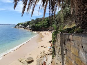
Lady Bay Beach is an official nudist beach found on the inside of South Head. Facing west, this beach is surrounded by a long cliff and a rocky shoreline[28][29]. There are great views across the water to Middle Head[30]. Officially declared a nude bathing beach by Neville Wran in 1976, nudity is only permitted on the beach and water. The beach is also known as ‘Lady Jane Beach’. You are welcome to use the beach clothed or unclad. More info.
Maps for the Lady Bay Beach walk
You can download the PDF for this walk to print a map.
These maps below cover the walk and the wider area around the walk, they are worth carrying for safety reasons.
| Sydney Heads | 1:25 000 Map Series | 91302N SYDNEY HEADS | NSW-91302N |
| Sydney | 1:100 000 Map Series | 9130 SYDNEY | 9130 |
Cross sectional view of the Lady Bay Beach bushwalking track
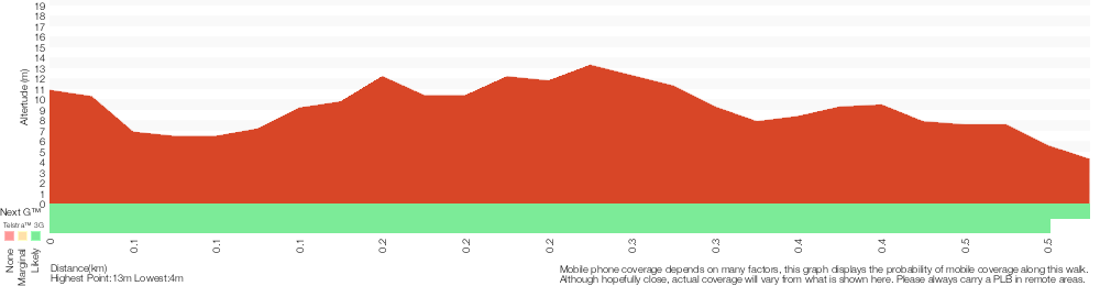
Analysis and summary of the altitude variation on the Lady Bay Beach
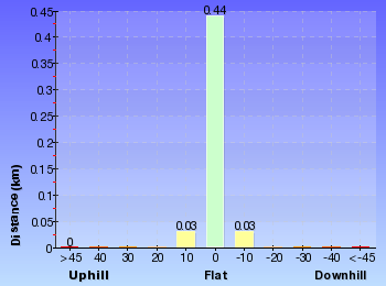
Overview of this walks grade – based on the AS 2156.1 – 2001
Under this standard, a walk is graded based on the most difficult section of the walk.
| Length | 992 m | ||
| Time | 30 mins | ||
| . | |||
| Grade 3/6 Moderate track |
AS 2156.1 | Gradient | Short steep hills (3/6) |
| Quality of track | Clear and well formed track or trail (2/6) | ||
| Signs | Clearly signposted (1/6) | ||
| Experience Required | No experience required (1/6) | ||
| Weather | Weather generally has little impact on safety (1/6) | ||
| Infrastructure | Generally useful facilities (such as fenced cliffs and seats) (1/6) |
Some more details of this walks Grading
Here is a bit more details explaining grading looking at sections of the walk
Gradient
420m of this walk has gentle hills with occasional steps and another 55m is flat with no steps. The remaining (25m) has short steep hills.
Quality of track
Around 440m of this walk follows a smooth and hardened path, whilst the remaining 55m follows a clear and well formed track or trail.
Signs
This whole walk, 500m is clearly signposted.
Experience Required
This whole walk, 500m requires no previous bushwalking experience.
weather
This whole walk, 500m is not usually affected by severe weather events (that would unexpectedly impact safety and navigation).
Infrastructure
This whole walk, 500m is close to useful facilities (such as fenced cliffs and seats).
Similar walks
A list of walks that share part of the track with the Lady Bay Beach walk.
358 m Return
15 mins
Easy track
1.7 km Circuit
45 mins
Easy track
2.5 km Circuit
1 Hr
Hard track
2.8 km Return
1 hr 15 mins
Easy track
4.1 km Circuit
1 hr 45 mins
Hard track
Other Nearby walks
A list of walks that start near the Lady Bay Beach walk.
243 m Circuit
15 mins
Easy track
886 m Return
30 mins
Hard track
842 m Return
30 mins
Moderate track
4.9 km Circuit
2 hrs 30 mins
Moderate track
144 m Return
7 mins
Very easy
1.7 km Return
1 Hr
Moderate track
904 m Return
30 mins
Easy track
2.2 km One way
1 Hr
Moderate track
896 m Return
20 mins
Easy track
1.7 km Circuit
40 mins
Easy track
2.5 km Circuit
1 Hr
Moderate track
1.8 km Circuit
40 mins
Easy track
Plan your trip to and from the walk here
The Lady Bay Beach walk starts and ends at the Camp Cove car park (gps: -33.83939, 151.27997)
Your transport options to Camp Cove car park are by;
![]() Bus. (get details)
Bus. (get details)
![]() Car. There is free parking available.
Car. There is free parking available.
(get details)
Short URL = http://wild.tl/lbb
Gallery images
There are other downloads I am still working on.
You will probably need to login to access these — still all free.
* KML (google earth file)
* GPX (GPS file)
Special Maps/ brochures
* A3 topo maps
* PDF with Lands Topo map base
* PDF with arial image (and map overlay)
I wanted to get the main site live first, this extra stuff will come in time.
Happy walking
Matt 🙂
South Head Heritage Trail
And Walk
South Head Heritage Trail

45 mins
1.7 km Circuit
64 m
Easy track
This walk explores the tip of Sydney Harbour’s South Head. On this walk, you will visit several historic and scenic places, following a footpath most of the way. You will start at Camp Cove, the first landing place for Europeans in Australia, and also visit a number of gun emplacements, designed to protect the shores from the threat of invasion. Also enjoy the panoramic ocean and harbour views from the cliff line at Hornby Lighthouse. A wonderful walk for those wanting to explore wide open views and get a glimpse of history.


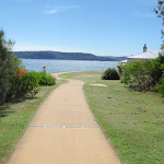
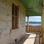
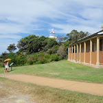
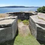
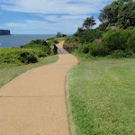


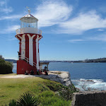

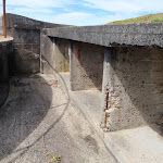

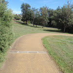
(0km) Camp Cove car park → Camp Cove Beach
50 m
1 mins
0m
-4m
Easy track
From the signposted ‘Camp Cove Car Park[1], this walk follows the ‘No Through Road’ sign[2] to the end of ‘Cliff St’. The footpath leads past a ‘Camp Cove timeline’ information sign[3] then, at the end of the road, turns left, coming to the front of the kiosk[4] at the northern end of Camp Cove Beach[5].
Camp Cove
Camp Cove is home to a lovely, yellow sand, north-east facing beach. The cove is on the protected side of South Head and is a popular spot for swimming and relaxing on the beach. At the northern end of the beach is a kiosk[6], toilet block[7] and an entrance to Sydney Harbour National Park[8].
The cove was an important location to the Cadigal (Gadigal) people who gathered fresh water, shellfish, launched their canoes and buried some of their people nearby.
This cove is also believed to be the first landing place for Europeans in 1788. The name Camp Cove was given during that landing and appears on the earliest maps of Sydney Harbour[11].
The cove was an important location to the Cadigal (Gadigal) people who gathered fresh water, shellfish, launched their canoes and buried some of their people nearby.
This cove is also believed to be the first landing place for Europeans in 1788. The name Camp Cove was given during that landing and appears on the earliest maps of Sydney Harbour[11].
(0.05km) Camp Cove Beach → Cannon
130 m
3 mins
7m
-3m
Easy track
Veer right: From the front of Camp Cove Beach kiosk[12], this walk crosses the beach (keeping the water to your left)[13] and climbs up the timber staircase[14]. From the intersection at the top of the stairs, this walk continues straight, along the timber boardwalk[15] that soon turns into a concrete path. The path soon comes to a wide, cobbled sandstone path[16] that leads up a disused cannon[17], gun emplacement and great harbour views[18].
Cannon
This cannon was placed here prior to 1890, along with the rest of this gun emplacement and rifle walls. The emplacement was designed to protect a military jetty and boat shed from the threat of an invasion. The ‘Cobblestone Road’ beside the cannon was built during the late 1870s or early 1880s and extends from the jetty in Camp Cove up to Hornby Road above. The road was build to carry supplies and ordnance from Camp Cove to the various military installations on south head. More info.
(0.18km) Cannon → Lady Bay Beach Int
290 m
6 mins
9m
-12m
Easy track
Continue straight: From the cannon, this walk heads up the path and steps and soon turns left to follow the old road[21]. The walk follows the old road, enjoying sweeping harbour views[22] (to your left). About 170m along this road (as it bends right), it passes a toilet block[23] then finds some garbage bins[24] at the end of the road. Here, the walk heads along the narrower footpath for ≈60m until coming to the signposted intersection above ‘Lady Bay Beach’[25].
(0.47km) Lady Bay Beach Int → Lady Bay Beach
30 m
1 mins
0m
-3m
Moderate track
Lady Bay Beach
Lady Bay Beach is an official nudist beach found on the inside of South Head. Facing west, this beach is surrounded by a long cliff and a rocky shoreline[28][29]. There are great views across the water to Middle Head[30]. Officially declared a nude bathing beach by Neville Wran in 1976, nudity is only permitted on the beach and water. The beach is also known as ‘Lady Jane Beach’. You are welcome to use the beach clothed or unclad. More info.
(0.47km) Lady Bay Beach Int → Lady Bay Lookout
90 m
2 mins
5m
-2m
Easy track
Continue straight: From the intersection, this walk heads gently downhill along the main path, keeping the large fence to your right[33]. The path leads down a few steps[34] and after ≈80m, heads up a few steps[35] then some more steps through a cleft in the rock[36] to find the fenced timber lookout platform looking over Lady Bay[37].
Lady Bay Lookout
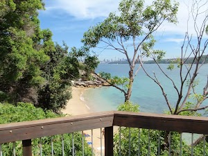
Some may find it strange having a lookout platform overlooking a nudist beach, but the harbour and city views are great[38]. This fenced and timber-decked lookout platform is found on the main walking track at the northern end of the bay. The lookout’s main view is south-west along the beach and harbour towards North Sydney. There are a few trees growing up over the view, which adds further interest to the outlook.
(0.62km) Circuit intersection → Lightkeepers Cottage
170 m
3 mins
3m
-10m
Very easy
Veer left: From the intersection, this walk heads along the short section of timber boardwalk, past the ‘South Head Heritage Trail’ sign[41], keeping the filtered water views to your left[42]. The walk then follows the flat footpath through the heath and after ≈70m, the path leads to a large clearing with great views across the water[43]. The walk continues along this path, bending to the right[44] in front of the old Lightkeeper’s cottage[45] and find a ‘Lightkeeper’s Cottages 1858’ sign [46] between the old house and a gun emplacement[47].
Lightkeepers Cottage
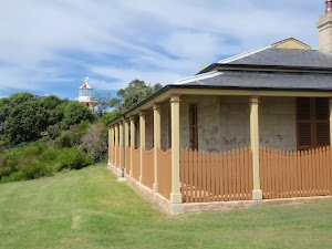
Two homes were built on South Head for the Hornby lighthouse keepers. The first cottage is the Head Lighthouse Keeper’s Cottage in the clearing, with the assistant’s house being closer to the lighthouse. This arrangement is unusual – normally, the head keeper’s house would be closer. The head lightkeeper’s house was completed about three years after the other house, around 1860. The first head lighthouse keeper was the well-motivated James Johnston, who was aboard the Dubar (a sailing ship on route from England) that smashed against the rocks near The Gap in 1857. 121 souls were lost that evening and James Johnston was the only survivor[49]. More info.
(0.79km) Lightkeepers Cottage → Hornby Lighthouse
90 m
2 mins
4m
-1m
Easy track
Continue straight: From the Lightkeepers Cottage, this walk heads along the footpath[50] across the small bridge[51], keeping the water views to your left. The path leads up and around to the right, past the concrete gun emplacement[52] to find the large red and white Hornby Lighthouse[53] and some great views.
Hornby Lighthouse
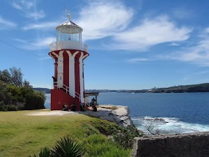
Opened by Sir William Denison (then Governor of New South Wales) in 1858, this distinct red and white vertical striped lighthouse was originally powered by a high-tech kerosene lantern. The lighthouse was built in response to two significant losses of life near South Head – firstly in 1857, the ‘Dubar’ (on it last leg from England), when 121 of the 122 people on board lost their lives, and soon after, the ‘Catherine Adamson’ when 21 lives were lost near North Head just two months later.
Since 1933, this lighthouse has been automated and is now powered with a 12 volt, 55 watt Quartz Halogen Lamp (similar to a down light in a kitchen). More info.
Since 1933, this lighthouse has been automated and is now powered with a 12 volt, 55 watt Quartz Halogen Lamp (similar to a down light in a kitchen). More info.
(0.88km) Hornby Lighthouse → Gun Emplacements
70 m
2 mins
7m
0m
Very easy
Gun Emplacements
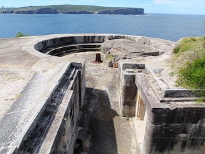
Gun emplacements like these have been built up and down the coast, and around the shores of Sydney Harbour. The first emplacement, built in 1788, was designed as a signalling station to notify the arrival of a ship. Then in 1839, the undetected arrival of ships, from the fast developing USA, caused a great concern. This triggered the building of the well-known fortifications at Bradleys Head and Fort Denison, as well as these ones at South Head. Another enemy at the time, France, then joined a campaign against a newer enemy – the Russians – in 1853, which prompted the completion of these gun emplacements. Guns were installed in 1872. In WWII, it was a Japanese enemy who these guns were trying to keep out, then in 1944, when the threat of invasion was less of a concern, the emplacements where disarmed[61]. More info.
(0.95km) Gun Emplacements → Camp Cove car park
750 m
16 mins
24m
-32m
Easy track
Continue straight: From the Gun Emplacements and ‘Fortifications 1854’[62] sign, this walk heads uphill along the footpath, away from the lighthouse. The path passes the second fortification[63] then an overgrown third fortification[64] as the path bends to the right [65]. The path then heads down and crosses the old road[66], following the path down the hill and soon comes to timber boardwalk, a four-way intersection and a large ‘South Head Heritage Trail’ sign[67] on your right.
Turn left: From the intersection, this walk heads directly away from the face of the ‘South Head Heritage Trail’ sign[68] along the timber boardwalk[69] and down a series of steps. The timber boardwalk soon leads to a fenced lookout with a view over Lady Bay[70].
Continue straight: From Lady Bay Lookout, this walk heads down the steps[71] next to the lookout and follows the footpath alongside the large fence[72]. The path heads up a series of steps to the signposted intersection above ‘Lady Bay Beach’[73].
Continue straight: From the intersection, this walk heads gently uphill along the footpath (keeping the water to the right) and after ≈60m, the path comes to the end of an old road. This walk continues along the old road, past the garage bins[74] and the large toilet block (on your left)[75]. The walk now follows the road as it leads around a sweeping left-hand bend, enjoying more harbour views until turning right onto a footpath, near a palm tree (just before the road meets a large fence). The walk heads down this path and some steps to find a disused cannon[76], gun emplacement and more great harbour views[77].
Continue straight: From the cannon, this walk heads down along the wide, cobbled sandstone path[78] (keeping the water views to your right). The walk then follows the footpath gently downhill to an intersection[79][80] (with a toilet block on the left). The walk heads straight, then down the steps and across the beach to the front of the Camp Cove Beach Kiosk[81].
Veer left: From the northern end of Camp Cove Beach, this walk heads up the concrete path next to the kiosk[82] to find the end of Cliff St. The walk follows the road past the ‘Camp Cove timeline’ information sign[83] to an intersection with Victoria St and the signposted ‘Camp Cove Car Park[84].
Maps for the South Head Heritage Trail walk
You can download the PDF for this walk to print a map.
These maps below cover the walk and the wider area around the walk, they are worth carrying for safety reasons.
| Sydney Heads | 1:25 000 Map Series | 91302N SYDNEY HEADS | NSW-91302N |
| Sydney | 1:100 000 Map Series | 9130 SYDNEY | 9130 |
Cross sectional view of the South Head Heritage Trail bushwalking track
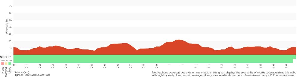
Analysis and summary of the altitude variation on the South Head Heritage Trail
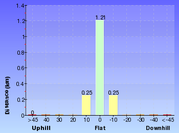
Overview of this walks grade – based on the AS 2156.1 – 2001
Under this standard, a walk is graded based on the most difficult section of the walk.
| Length | 1.7 km | ||
| Time | 45 mins | ||
| . | |||
| Grade 2/6 Easy track |
AS 2156.1 | Gradient | Gentle hills with occasional steps (2/6) |
| Quality of track | Clear and well formed track or trail (2/6) | ||
| Signs | Clearly signposted (1/6) | ||
| Experience Required | No experience required (1/6) | ||
| Weather | Weather generally has little impact on safety (1/6) | ||
| Infrastructure | Generally useful facilities (such as fenced cliffs and seats) (1/6) |
Some more details of this walks Grading
Here is a bit more details explaining grading looking at sections of the walk
Gradient
Around 1.4km of this walk has gentle hills with occasional steps, whilst the remaining 350m is flat with no steps.
Quality of track
Around 1.6km of this walk follows a smooth and hardened path, whilst the remaining 110m follows a clear and well formed track or trail.
Signs
This whole walk, 1.7km is clearly signposted.
Experience Required
This whole walk, 1.7km requires no previous bushwalking experience.
weather
This whole walk, 1.7km is not usually affected by severe weather events (that would unexpectedly impact safety and navigation).
Infrastructure
This whole walk, 1.7km is close to useful facilities (such as fenced cliffs and seats).
Similar walks
A list of walks that share part of the track with the South Head Heritage Trail walk.
358 m Return
15 mins
Easy track
992 m Return
30 mins
Moderate track
2.5 km Circuit
1 Hr
Hard track
2.8 km Return
1 hr 15 mins
Easy track
4.1 km Circuit
1 hr 45 mins
Hard track
Other Nearby walks
A list of walks that start near the South Head Heritage Trail walk.
243 m Circuit
15 mins
Easy track
886 m Return
30 mins
Hard track
842 m Return
30 mins
Moderate track
4.9 km Circuit
2 hrs 30 mins
Moderate track
144 m Return
7 mins
Very easy
1.7 km Return
1 Hr
Moderate track
904 m Return
30 mins
Easy track
2.2 km One way
1 Hr
Moderate track
896 m Return
20 mins
Easy track
1.7 km Circuit
40 mins
Easy track
2.5 km Circuit
1 Hr
Moderate track
1.8 km Circuit
40 mins
Easy track
Plan your trip to and from the walk here
The South Head Heritage Trail walk starts and ends at the Camp Cove car park (gps: -33.83939, 151.27997)
Your transport options to Camp Cove car park are by;
![]() Bus. (get details)
Bus. (get details)
![]() Car. There is free parking available.
Car. There is free parking available.
(get details)
Short URL = http://wild.tl/shht
Gallery images
There are other downloads I am still working on.
You will probably need to login to access these — still all free.
* KML (google earth file)
* GPX (GPS file)
Special Maps/ brochures
* A3 topo maps
* PDF with Lands Topo map base
* PDF with arial image (and map overlay)
I wanted to get the main site live first, this extra stuff will come in time.
Happy walking
Matt 🙂
Comments