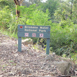
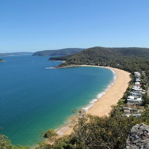
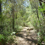
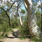
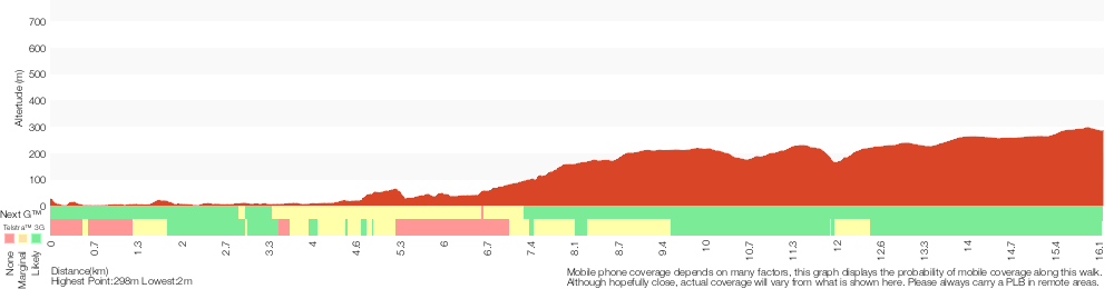
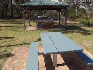
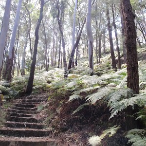
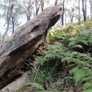
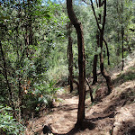
This is a great walk, crossing the middle of Brisbane Water National Park and visiting several highlights including Rocky Ponds. Starting with a ferry trip from Brooklyn, this walk follows a series of faint tracks, clear tracks and management trails. There is an alternate route described in the notes as a way around the Defile Track which and be very faint. You will enjoy a wide range of panoramic views from TumblecowII ridge, Rocky Ponds (Tank Creek) and an optional side trip to enjoy the view from Mount Wondabyne. The walk finishes with a walk of contrast, beside the Woy Woy landfill and a road walk to Woy Woy Station. A great day out or make it an overnighter by camping overnight at Tank Creek or Mt Wondabyne.* This walk passes through very remote areas and sections have no visible track. At least one person in your group should have training and experience in off track walking and navigation. Even with these notes and a GPS these extra skills and equipment are required.
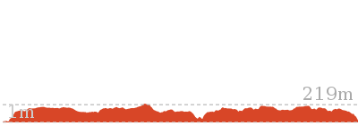
Little Wobby to Woy Woy via Rocky Ponds


6 hrs 30 mins

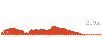
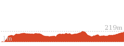
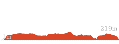
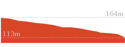
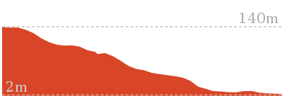
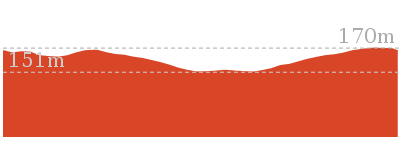
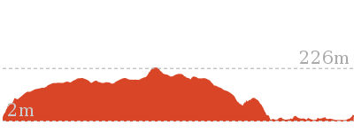
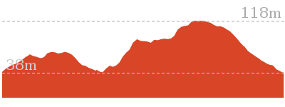
588 m
Experienced only


Permit Required
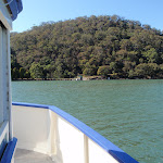
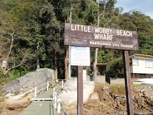
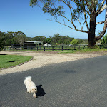
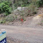
(0km) Brooklyn Ferry Terminal → Little Wobby Wharf

3.1 km
20 mins
8m
-4m
Easy track
Alternatively, you can catch a water taxi, which generally costs about $100 per group of 4 and needs to be booked ahead. There are a few options – try Hawkesbury River Water Taxi on 0400 600 111 or Rick on 0448 101 010. More info.
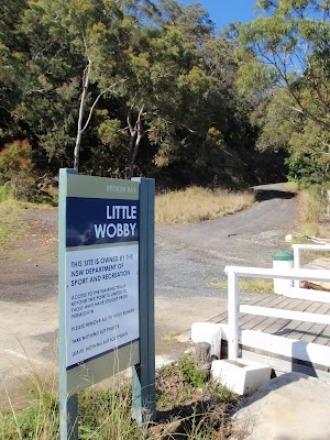
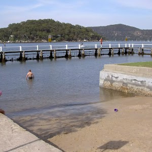
Little Wobby
(3.08km) Little Wobby Beach Wharf → Little Wobby Sport and Rec Wharf
400 m
9 mins
20m
-22m
Easy track
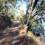
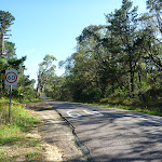
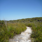
(3.48km) Little Wobby Sport and Rec Wharf → Int of Pacific Trail and Defile Track
870 m
19 mins
43m
-38m
Easy track
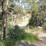
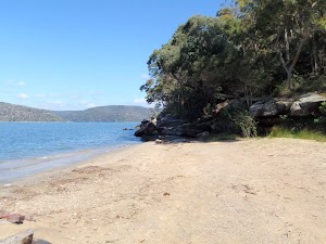
Spring Beach
(4.35km) Int of Pacific Trail and Defile Track → Int of Midway trail and The Defile
3.7 km
1 hr 24 mins
250m
-127m
Hard track
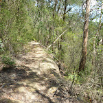
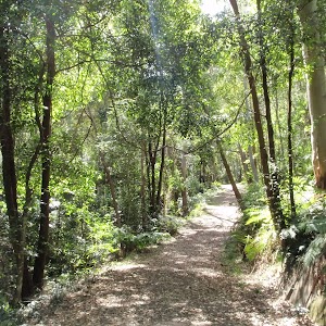
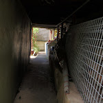
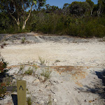
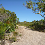
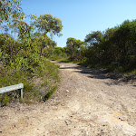
Continue straight: From the intersection, keeping the water views to the right, this walk heads gently up hill along the management trail, soon passing an old toilet. The trail winds along the hill for a while (passing an old trail on the left just after the white posts), soon coming to and passing a green concrete pumping station (Forty Year Spring). About 650m past the spring, the trail passes the signposted ‘Rock Climbing’ track and then comes to an intersection just above the signposted ‘Juno Head Campsite’.
Continue straight: From the intersection, this walk follows the power lines along the management trail (keeping the water views to the right). The trail rounds the side on the gully then, just before passing under the power lines, the trail comes to a signposted intersection with the ‘Midway Trail’.
Turn left : From the intersection, this walk follows the ‘Midway Trail’ and red post up the hill along the narrow track. The track soon climbs up through a rocky outcrop, leading to a clearing and campsite. From this clearing, the trail follows the red post up the hill for another 350m, coming to another clearing and campsite at the unsignposted intersection with the Magpie Trail.
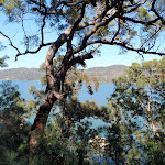
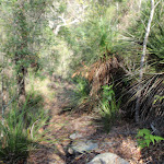
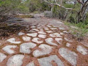
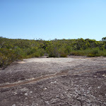
Veer left: From the intersection and campsite, this walk follows the red and yellow marker north-west along the track. The track follows the ridge top, with the occasional clearing giving great views of the Hawkesbury River on the left. The red and yellow markers lead through a cleft in the rocks then up through a small gully in a rocky outcrop, then the walk comes to a fairly large tessellated rock platform (surround by heath, this is also the intersection with the unsignposted, yellow marker, Horseshoe trail).
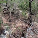
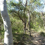
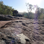
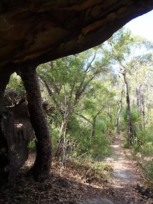
Continue straight: From the tessellated rock platform, this walk follows the red painted marker north along the ridge (keeping the filtered water views to the left). The track follows a narrow rock platform for about 180m and then, just past the good views of the river, the walk steps off the rock and follows a rocky track. The track passes some rocky outcrops and more filtered views and, about 130m past the small rock wall (on the left), the track comes to a three way intersection with The Defile track on the left (and a large scribbly gum on the right). Now Continue straight to rejoin the main walk .
(4.35km) Int of Pacific Trail and Defile Track → Int of Midway trail and The Defile
740 m
18 mins
131m
-6m
Experienced only
(5.09km) Int of Midway trail and The Defile → Tumblecow 2 flat rock
1.2 km
28 mins
64m
-78m
Hard track
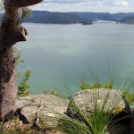
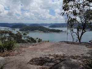
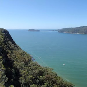
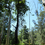
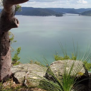
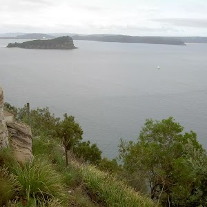
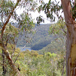
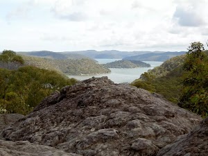
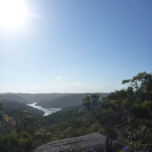
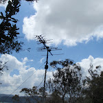
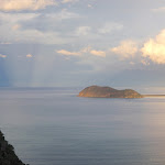
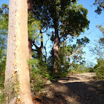
Veer right: From the intersection, this walk heads north, passing under the power lines and past the telegraph poles. The track heads through the scrub for a while before passing a few nice vantage points with great views over Brooklyn, then coming to a view with two TV antennas mounted on small masts. The track continues along the top of the ridge for another 350m, passing some more great views and coming to two more TV antennas on a another rocky outcrop. About 70m past these antennas, the track comes to a large flat rock platform with two more TV antennas and great views over Brooklyn and the Hawkesbury River.
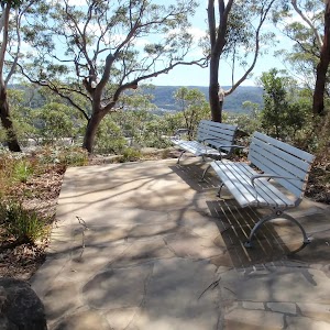
Tumblecow 2 flat rock
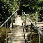
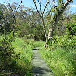
(6.24km) Tumblecow 2 flat rock → Tank Creek Crossing
2.6 km
57 mins
99m
-154m
Hard track
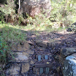
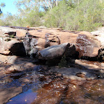
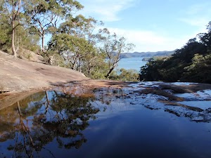
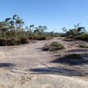
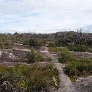
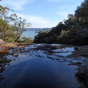
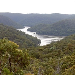
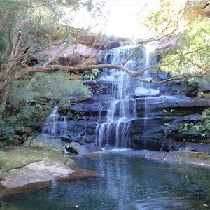
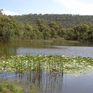
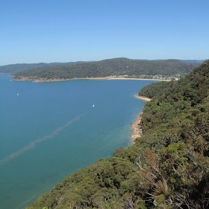
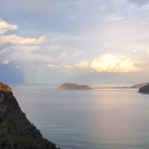
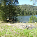
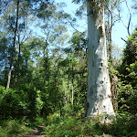
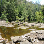
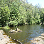
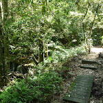
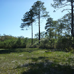
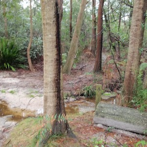
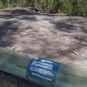
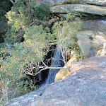
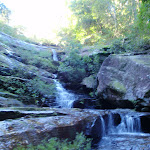
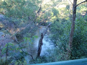
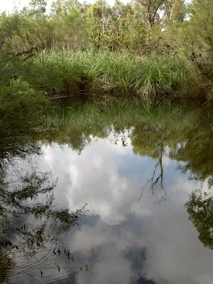
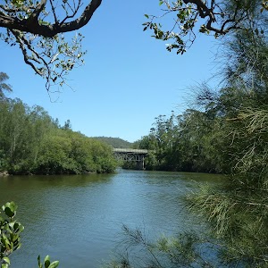
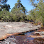
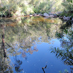
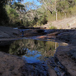
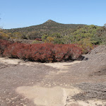
Rocky Ponds
(8.84km) Tank Creek Crossing → Tank Creek last fall
360 m
7 mins
1m
-27m
Hard track
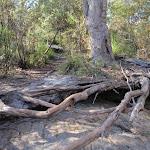
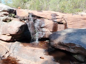
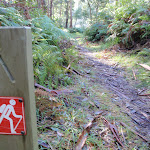
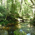
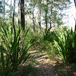
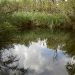
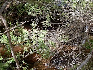
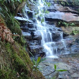
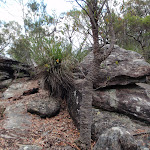
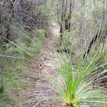
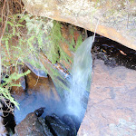
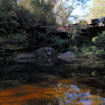
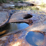
Continue straight: From the intersection, this walk heads south-west, away from the main rock wall, and follows the track through the grass trees (keeping the valley to the left). The track passes another short track (on the left, leading a rock pool) and a short distance later the track comes next to the creek edge and a large sandstone platform. This is the top of the last waterfall on Tank Creek, with great views up the Hawkesbury River (it is unfenced – care is needed). At the end of this side trip, retrace your steps back to the main walk then Turn left.
Jeannie’s Pool
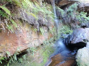
Tank Creek last fall
(8.84km) Tank Creek Crossing → Int of Highway Ridge Track and Tanks Campsite track
100 m
2 mins
8m
0m
Hard track
Turn right: From the gully, this walk head upstream through this gully for a few meters. The walk then turns left up the eroded track, coming to a small clearing and a wider sandy track. The walk follows this sandy track up the hill for about 50m before coming to a three-way intersection (with a track leading to the campsite on the left).
(8.94km) Int of Highway Ridge Track and Tanks Campsite track → Tank Creek Campsite
50 m
1 mins
1m
0m
Hard track
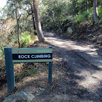
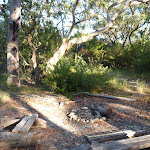
Tank Creek Campsite
(8.94km) Int of Highway Ridge Track and Tanks Campsite track → Int of Rocky Ponds and the GNW
4.3 km
1 hr 19 mins
154m
-68m
Hard track
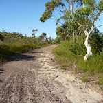
Veer left: From the intersection, this walk heads north along the clear management trail, keeping the hill and rocks to the left. After about 750m, the trail heads up a short, steep hill. From here, the trail winds more gently uphill and crosses a long sandstone platform. After the sandstone platform, the trail continues uphill for about 1.3km, flattening out for the last half before coming to a ‘T’ intersection and a sign pointing back to ‘Rocky Ponds Trail’.
(13.27km) Int of Rocky Ponds Trail and Tunnel Track → Mt Wondabyne Peak
1.5 km
32 mins
90m
-9m
Hard track
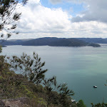
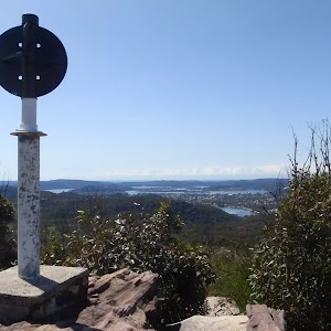
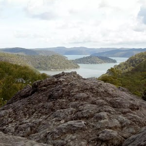
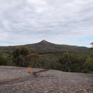
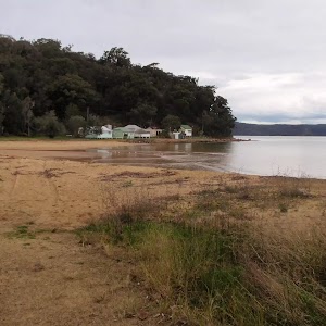
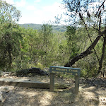
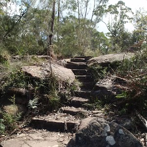
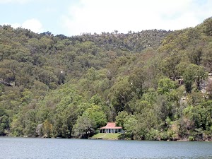
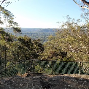
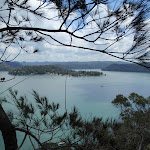
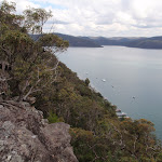
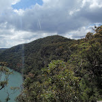
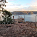
Turn left: From the intersection, this walk follows the GNW arrow marker as well as the ‘Mt Wondabyne’[17] and ‘Girrakool’[18] signs uphill along the management trail. The trail winds up the hill for about 300m find a view of Mount Wondabyne[19] – there are also nice views behind (and to the right) across Woy Woy and the Brisbane Water[20]. The trail continues uphill for another 400m to end at a large clearing[21] (turning circle) at the base of a rock wall. This is the Mt Wondabyne Campsite[22] – there is also a sign pointing back down to ‘Patonga’[23].
Turn right: From the clearing (campsite), this walk follows the ‘Mooney Mooney rest area’ sign[24] north gently uphill along the rocky track[25]. After about 90m, this track comes to a three-way intersection[26] (with the Mt Wondabyne peak track, on the right[27]), marked with a GNW arrow post.
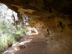
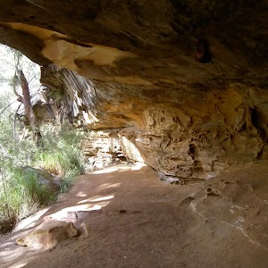
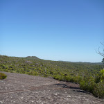
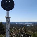
Turn right: From the intersection, this walk follows the Mt Wondabyne peak track north-east as it heads uphill directly towards Mt Wondabyne. The track is leads gently at first then starts to climb up a series of rock ledges[28]. After about 60m, the track passes a small cave[29] (large enough for 2 or 3 people to lie in). The track then continues to climb for another 90m, up the rocky track then for through a grove of small trees[30], to come to the first peak[31]. The faint track continues along the ridge for another 60m then comes to the main peak, where there is an old trig station[32] and great panoramic views[33]. At the end of this side trip, retrace your steps back to the main walk then Continue straight.
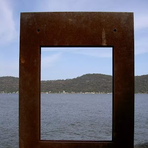
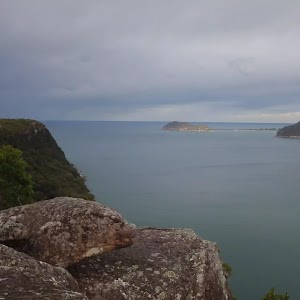
Mt Wondabyne

(13.27km) Int of Rocky Ponds Trail and Tunnel Track → Int of Great North Walk and Tunnel Track
160 m
3 mins
1m
-7m
Moderate track
(13.43km) Int of GNW and Tunnel Trail → Woy Woy Landfill site front gates
2.8 km
57 mins
62m
-197m
Moderate track
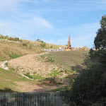
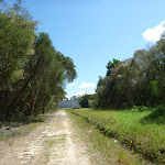
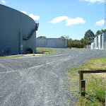
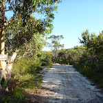
Turn left: With the Patonga-bound bush track on the right, this walk follows the management trail east, down the long, gentle hill. The trail gradually steepens as it winds down to the Woy Woy Landfill site. The walk then follows the landfill fence past a building and steps through a gap in the fence. The walk then heads along the gravel driveway to the landfill road.
Veer left: From the Woy Woy landfill site, this walk down the road, winding to the bottom where it flattens out at the Woy Woy Landfill front gates (these gates are locked at night but there is a gap for walkers to get through just up to the right of the gates).
(16.22km) Woy Woy Landfill site front gates → Woy Woy train station
2.9 km
45 mins
6m
-21m
Easy track
Continue straight: From the intersection, this walk follows Railway Street through the residential area, past the shopping centre to the Woy Woy train station.
Maps for the Little Wobby to Woy Woy via Rocky Ponds walk
You can download the PDF for this walk to print a map.
These maps below cover the walk and the wider area around the walk, they are worth carrying for safety reasons.
| Gosford | 1:25 000 Map Series | 91312S GOSFORD | NSW-91312S |
| Cowan | 1:25 000 Map Series | 91304N COWAN | NSW-91304N |
| Broken Bay | 1:25 000 Map Series | 91301N BROKEN BAY | NSW-91301N |
| Ku-ring-gai Chase National Park Tourist Map | 1:40 000 Map Series | CMA Ku-ring-gai Chase National Park Tourist Map | CMA Ku-ring-gai Chase National Park Tourist Map |
| Gosford | 1:100 000 Map Series | 9131 GOSFORD | 9131 |
| Sydney | 1:100 000 Map Series | 9130 SYDNEY | 9130 |
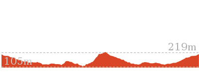
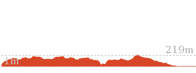
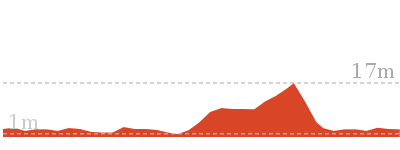
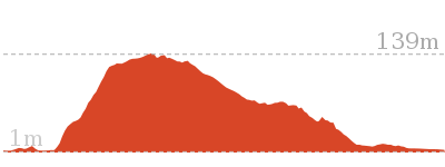
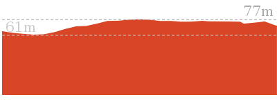
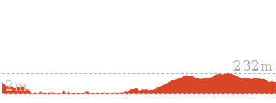
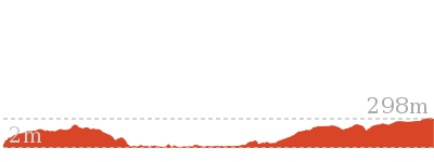
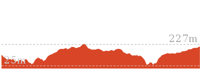
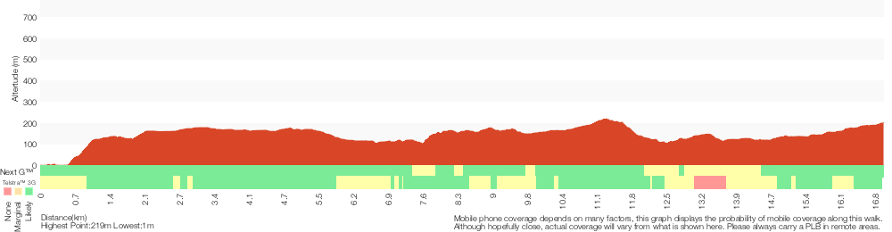
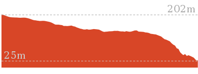
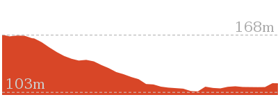
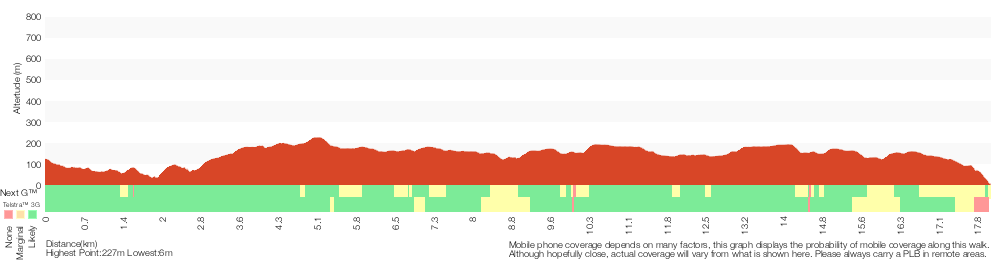
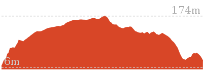
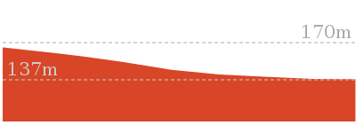
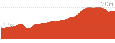
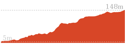
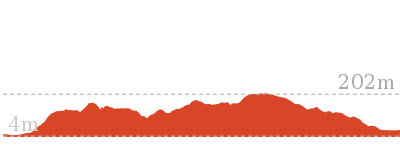
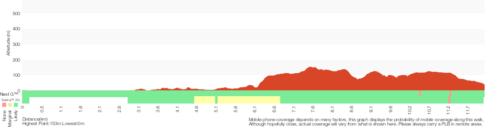
Cross sectional view of the Little Wobby to Woy Woy via Rocky Ponds bushwalking track
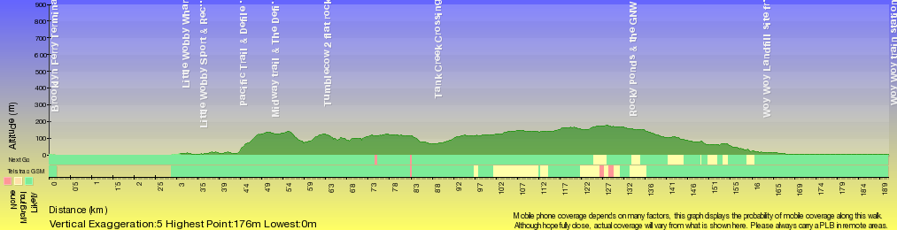
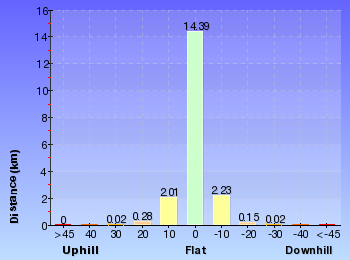
Analysis and summary of the altitude variation on the Little Wobby to Woy Woy via Rocky Ponds
Overview of this walks grade – based on the AS 2156.1 – 2001
Under this standard, a walk is graded based on the most difficult section of the walk.
| Length | 16.1 km | ||
| Time | 6 hrs 30 mins | ||
| . | |||
| Grade 5/6 Experienced only |
AS 2156.1 | Gradient | Very steep (4/6) |
| Quality of track | Rough unclear track (5/6) | ||
| Signs | No directional signs (5/6) | ||
| Experience Required | Some bushwalking experience recommended (3/6) | ||
| Weather | Forecast, unforecast storms and severe weather may impact on navigation and safety (4/6) | ||
| Infrastructure | Limited facilities (such as cliffs not fenced, significant creeks not bridged) (4/6) |
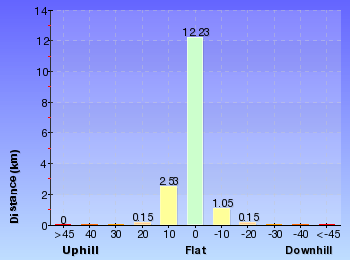
Some more details of this walks Grading
Here is a bit more details explaining grading looking at sections of the walk
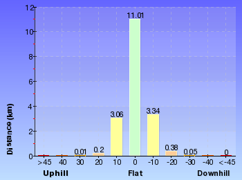
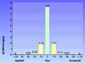
Gradient
9km of this walk has short steep hills and another 6km has gentle hills with occasional steps. Whilst another 3.1km is flat with no steps and the remaining 740m is very steep.
Quality of track
6km of this walk follows a clear and well formed track or trail and another 4.4km follows a formed track, with some branches and other obstacles. Whilst another 3.9km follows a smooth and hardened path and a 3.9km section follows a rough track, where fallen trees and other obstacles are likely. The remaining 740m follows a rough unclear track.
Signs
10km of this walk is clearly signposted and another 8km has minimal directional signs. Whilst another 740m Has no directional signs and the remaining 190m has directional signs at most intersection.
Experience Required
Around 10km of this walk requires no previous bushwalking experience, whilst the remaining 9km requires some bushwalking experience.
weather
16km of this walk is not usually affected by severe weather events (that would unexpectedly impact safety and navigation) and another 2.6km is affected by forecast, unforecast storms and severe weather events that may impact on navigation and safety. The remaining (840m) is affected by storms that may impact your navigation and safety.
Infrastructure
10km of this walk is close to useful facilities (such as fenced cliffs and seats) and another 4.6km has limited facilities (such as cliffs not fenced, significant creeks not bridged). The remaining (4.3km) has limited facilities (such as not all cliffs fenced).
Similar walks
A list of walks that share part of the track with the Little Wobby to Woy Woy via Rocky Ponds walk.
10.8 km Circuit
4 hrs 30 mins
Hard track
15.4 km One way
6 hrs
Hard track
15.5 km One way
5 hrs 45 mins
Hard track
17 km One way
6 hrs 30 mins
Hard track
18.1 km Return
8 hrs
Hard track
19.5 km One way
7 hrs 30 mins
Hard track
20.7 km One way
8 hrs 30 mins
Hard track
24 km One way
8 hrs 30 mins
Experienced only
24.8 km One way
10 hrs
Hard track
24.8 km One way
2 Days
Hard track

28.1 km One way
2 Days
Experienced only
33.4 km One way
2 Days
Hard track

41.5 km One way
3 Days
Hard track
Other Nearby walks
A list of walks that start near the Little Wobby to Woy Woy via Rocky Ponds walk.
931 m Circuit
30 mins
Moderate track
1.4 km Return
30 mins
Very easy
4.3 km One way
1 hr 45 mins
Moderate track
4.3 km Return
2 hrs
Moderate track
2.2 km One way
1 Hr
Moderate track
2.8 km One way
1 hr 15 mins
Moderate track
756 m Return
20 mins
Easy track
5.1 km Return
2 hrs
Moderate track
1.4 km Return
30 mins
Easy track

2.8 km Circuit
1 hr 30 mins
Very experienced only

2.1 km Return
1 Hr
Moderate track

1.9 km Return
1 Hr
Hard track
Plan your trip to and from the walk here
The Little Wobby to Woy Woy via Rocky Ponds walk starts at the Brooklyn Ferry Terminal (gps: -33.546533, 151.22724)
Your transport options to Brooklyn Ferry Terminal are by;
![]() Train. (get details)
Train. (get details)
![]() Bus. (get details)
Bus. (get details)
![]() Car. There is free parking available.
Car. There is free parking available.
(get details)
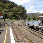
The Little Wobby to Woy Woy via Rocky Ponds ends at the Woy Woy train station (gps: -33.485814, 151.32361)
Your transport options to Woy Woy train station are by;
![]() Train. (get details)
Train. (get details)
![]() Bus. (get details)
Bus. (get details)
![]() Car. There is free parking available.
Car. There is free parking available.
(get details)


Short URL = http://wild.tl/lwtwwvrp
Gallery images
There are other downloads I am still working on.
You will probably need to login to access these — still all free.
* KML (google earth file)
* GPX (GPS file)
Special Maps/ brochures
* A3 topo maps
* PDF with Lands Topo map base
* PDF with arial image (and map overlay)
I wanted to get the main site live first, this extra stuff will come in time.
Happy walking
Matt 🙂
Mooney Mooney Creek Trackhead to Somersby

6 hrs
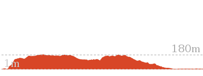
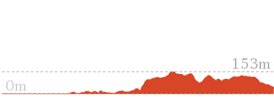
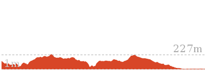
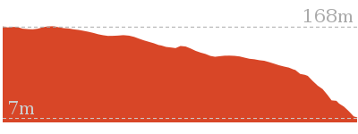
680 m
Hard track
This enjoyable walk starts from where the old Pacific Hwy where you walk along dirt roads and trails for while alongside the wide Mooney Mooney Creek, and under the huge F3 Mooney Mooney bridge. The wide track continues upstream, passing a few campsites before crossing the wide creek at a pleasant large rock platform. Not too long after crossing the creek you will pass the lower Mooney Mooney Dam where the old trail leads you uphill past another campsite, a quarry to the Somersby Reservoir. The track then leads past some rural properties and across the delightful Robinson Creek among the Gymea Lilies before finishing with a section of road walking to the Somersby Store.


(0km) Mooney Mooney Creek Trackhead → Int of Karool Rd and Old Pacific Highway
320 m
7 mins
12m
-25m
Easy track
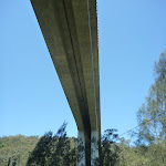
Old Pacific Highway Mooney Mooney Creek Bridge
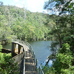
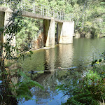
This road became the ‘Old Pacific Highway’ upon the opening of the F3, or Sydney-Newcastle Freeway, in the 1980s. This bridge is the smaller of two crossing Mooney Mooney Creek – the other, Mooney Mooney Bridge, is part of the F3 freeway and is the highest road bridge in Australia.
(0.32km) Int of Karool Rd and Old Pacific Highway → National Park Gate
1.2 km
20 mins
19m
-28m
Easy track
Veer left: From the ‘Y’ intersection[16], this walk follows the ‘The Great North Walk’ sign[17] along the upper dirt road to pass under the Mooney Mooney (F3 freeway) Bridge[18]. Just over 250m after passing under the tall bridge, this walk leads up to a large turning area[19] just before the locked gate[20], marked with a ‘Brisbane Water National Park’ sign[21].
(1.5km) National Park Gate → Mooney Mooney Creek crossing
4 km
1 hr 21 mins
148m
-125m
Moderate track
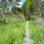
Veer right: From the intersection[29] just above the clearing, this walk follows the GNW arrow post[30] down along the track, keeping the clearing and campsite[31] to the right. The track soon leads over a small flat timber bridge[32] then over the next 60m, the track heads under the high tension power lines (past the caution sign[33]) and then along a short section of timber boardwalk[34]. About 20m later, this walk veers right at a Y-intersection[35], then continues along the mostly flat track beside Mooney Mooney Creek for about 300m, to cross a small rocky tidal creek[36]. The track then continues through the tall forest[37] beside Mooney Mooney Creek for about 600m, passing a couple of she-oak stands[38] before the track then bends left and comes to an indistinct intersection[39] beside a timber and metal footbridge[40].
Continue straight: From the intersection, this walk crosses the timber and metal footbridge[41] over a tidal, unnamed creek[42] to then turn right and follow the track which soon bends left. Keeping Mooney Mooney Creek to the right[43], this track passes a small cliff[44] and then follows the mostly flat track through the tall forest[45] for about 170m to come to a large clearing with tall blue gums[46]. (This was once a campsite, camping is not safe and not permitted)
Continue straight: From the campsite[47], this walk follows the clear track north, keeping the wide Mooney Mooney Creek to your right. The clear, wide and mostly flat track leads alongside the creek[48] for about 1.2km to come to the southern bank of Ausburn Creek[49] (about 130m past a rock wall[50], on your left), a few metres above its confluence with Mooney Mooney Creek[51]
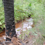
Continue straight: From the south bank of Ausburn Creek, this walk crosses the narrow rock platform and creek[52], then follows the track fairly steeply uphill[53] for about 200m. At the top of this climb, the track gently undulates[54] alongside Mooney Mooney Creek for about 700m before heading down to find a large rock platform[55] on the western bank of Mooney Mooney Creek. This large rock platform is a natural ford of the perennial Mooney Mooney Creek[56] and is home to a scattering of small and large waterholes[57].
(5.49km) Mooney Mooney Creek crossing → Lower Mooney Mooney Dam
1.2 km
28 mins
71m
-44m
Moderate track
Lower Mooney Dam
(6.71km) Lower Mooney Mooney Dam → Int of the dam trail and the old Somersby Falls track
1.7 km
40 mins
143m
-25m
Moderate track
(8.37km) Int of the dam trail and the old Somersby Falls track → Int GNW and Somersby Gardens private track
180 m
4 mins
5m
-6m
Easy track
(8.55km) Great North walk sign → Somersby Gardens
660 m
15 mins
46m
-7m
Hard track
This walk is now going onto private land, the owner has kindly given permission for walkers to go this way – please stay to the track, stay quiet and respect the owners privacy.
The walk continues along the eroded track[83] for 200m to come to a clearing and corner of a fence. Here the walk continues straight following the farm trail[84] for 120m as the farm views begin to open up and you pass a few tires and timber wall marking an old challenge course[85]. Soon after these tires this walk comes to a larger clearing on the right[86]. Here, this walk veers right to soon come to a clearly defined trail where you continue straight following the farm trail through the rock cutting[87]. About 150m later this walk comes to a small parking area beside ‘Somersby Garden’. Please respects the owners and guests privacy. At the end of this side trip, retrace your steps back to the main walk then Turn right.
Somersby Gardens
(8.55km) Int GNW and Somersby Gardens private track → Quarry Camping Area
350 m
9 mins
32m
-4m
Moderate track
Quarry Camping Area
(8.9km) Quarry Camping Area → Somersby Reservoir
1.1 km
20 mins
24m
-10m
Moderate track
Veer left: From the intersection, this walk follows GNW arrow marker[115] gently downhill along the dirt road[116]. This walk follows the road for about 400m to come to a large clearing with two large water reservoirs tanks[117]. This walk continues past the two reservoirs[118] (and past the treatment plant building[119], on your left) to come to a ‘The Great North Walk’ sign[120] just in front of a small brick building[121].
(10.01km) Somersby Reservoir → South end of Robinson Crk Track
1.2 km
25 mins
42m
-46m
Moderate track
Veer right: From the intersection, this walk follows the management trail uphill[133], keeping the power lines just to your right. After about 40m, this walk follows the GNW arrow post left[134] (ignoring the ‘Private Property’[135] trail ahead) as the track winds gently uphill for about 250m before veering left, ignoring another ‘Private Property’ track[136] (on your right). The mostly flat track now leads along the side of the hill[137] for about 100m before passing under another set of power lines[138] and leading right, steeply up the short rocky hill[139]. At the top of this hill, the track leads to the end of a trail[140], but immediately veers right[141] to follow a track along a fence for about 60m before rejoining the same power line management trail[142].
(11.21km) South end of Robinson Crk Track → End of Robinson Road
2.2 km
48 mins
104m
-88m
Hard track
The track leads into the bush among gymea lilies[145] (Doryanthes excelsa) and eucalypts[147] for almost 300m, crossing a couple of short flat timber bridges[148] to then head along a few sections of timber board walk through a weedy section[149] of bush. The track then continues gently downhill for another 150m to cross over a trail[150]. Following the GNW arrow post, this track now begins to lead more steeply down for about 250m, passing through another large grove of gymea lilies[151], a small cave[152] (on your left). The walk continues down the timber then stone steps[153] to head into the dense moist forest and across a flat timber bridge[154], coming into view of the creek[155]. Here the walk bends right and leads beside the creek for a short time before bending left, following the GNW arrow post across the creek flowing over the mossy rock bed[156]. Just downstream is a small pool and cascade[157].
Here the walk starts to climb up the other side of the valley[158], soon crossing a small flat timber bridge[159]. The track then winds steeply[160] out of the ferny and densely forested valley, up a series of timber and stone steps for about 130m where another GNW arrow post marks[161] the end of this section of steep climbing. This track now leads gently up among some tall eucalypts[162] and past a large grove of gymea lily[163] for about 230m to come to a T-intersection[164] with a wide management trail.
Veer right: From the intersection, this walk follows the GNW arrow post uphill[165] along the wide sandy trail for about 40m to pass a faint trail[166] (on your right). Then about 120m further up the main trail, this walk comes a T-intersection[167] marked with a couple more GNW arrow posts.
Turn right: From the intersection, this walk follows the GNW arrow post[168] gently uphill along the sandy trail[169]. The trail soon leaves the wooded forest and after about 120m, this walk veers left at an intersection in a clearing[170]. After another 120m, the walk heads past a large grassy clearing[171] (on your right) with some tall pine trees[172]. The sandy trail continues for another 150m, past a few scribbly gums[173], and comes to a Y-intersection marked with a ‘The Great North Walk’ sign[174] (pointing left).
Veer left: From the intersection, this walk follows the ‘The Great North Walk’ sign[175] along the track, initially keeping the sandy trail to the right for a short distance. The track soon bends left, then winds over a small rise through the scribbly gum forest[176] for about 400m before heading over a short section of green boardwalk[177]. A short distance later, this walk crosses a green timber footbridge[178] and comes to an intersection at the end of the dirt Robinson Road[179].
(13.4km) End of Robinson Road → Somersby Store
2.7 km
50 mins
80m
-21m
Moderate track
Somersby Store

Maps for the Mooney Mooney Creek Trackhead to Somersby walk
You can download the PDF for this walk to print a map.
These maps below cover the walk and the wider area around the walk, they are worth carrying for safety reasons.
| Gunderman | 1:25 000 Map Series | 91313S GUNDERMAN | NSW-91313S |
| Gosford | 1:25 000 Map Series | 91312S GOSFORD | NSW-91312S |
| Wyong | 1:25 000 Map Series | 91312N WYONG | NSW-91312N |
| Gosford | 1:100 000 Map Series | 9131 GOSFORD | 9131 |
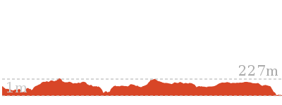
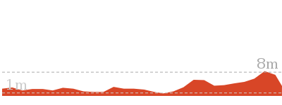
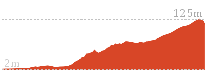
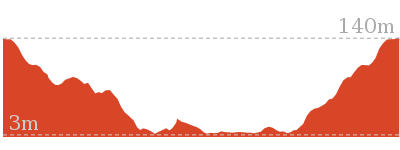
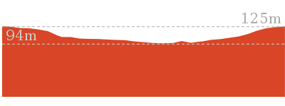
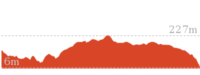
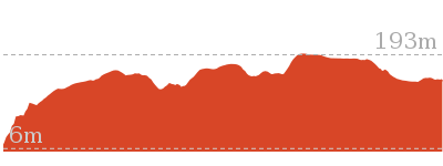
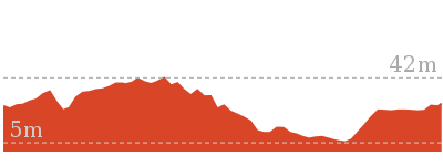
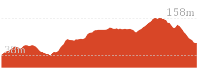
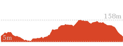
Cross sectional view of the Mooney Mooney Creek Trackhead to Somersby bushwalking track
Analysis and summary of the altitude variation on the Mooney Mooney Creek Trackhead to Somersby
Overview of this walks grade – based on the AS 2156.1 – 2001
Under this standard, a walk is graded based on the most difficult section of the walk.
| Length | 16.1 km | ||
| Time | 6 hrs | ||
| . | |||
| Grade 4/6 Hard track |
AS 2156.1 | Gradient | Very steep (4/6) |
| Quality of track | Formed track, with some branches and other obstacles (3/6) | ||
| Signs | Directional signs along the way (3/6) | ||
| Experience Required | Moderate level of bushwalking experience recommended (4/6) | ||
| Weather | Storms may impact on navigation and safety (3/6) | ||
| Infrastructure | Limited facilities (such as cliffs not fenced, significant creeks not bridged) (4/6) |
Some more details of this walks Grading
Here is a bit more details explaining grading looking at sections of the walk
Gradient
6km of this walk has short steep hills and another 4.9km has gentle hills with occasional steps. Whilst another 3.9km is flat with no steps and the remaining 1.3km is very steep.
Quality of track
8km of this walk follows a formed track, with some branches and other obstacles and another 4.7km follows a clear and well formed track or trail. The remaining (3.9km) follows a smooth and hardened path.
Signs
Around 10km of this walk has directional signs at most intersection, whilst the remaining 7km is clearly signposted.
Experience Required
10km of this walk requires no previous bushwalking experience and another 4.5km requires some bushwalking experience. The remaining (1.3km) requires a leader a with moderate level of bushwalking experience.
weather
Around 14km of this walk is not usually affected by severe weather events (that would unexpectedly impact safety and navigation), whilst the remaining 1.9km is affected by storms that may impact your navigation and safety.
Infrastructure
14km of this walk is close to useful facilities (such as fenced cliffs and seats) and another 1.4km has limited facilities (such as not all cliffs fenced). The remaining (1.3km) has limited facilities (such as cliffs not fenced, significant creeks not bridged).
Similar walks
A list of walks that share part of the track with the Mooney Mooney Creek Trackhead to Somersby walk.
20 km Circuit
7 hrs 30 mins
Moderate track
26.2 km One way
10 hrs
Hard track

26.2 km One way
2 Days
Hard track
41.5 km One way
3 Days
Hard track
Other Nearby walks
A list of walks that start near the Mooney Mooney Creek Trackhead to Somersby walk.
803 m Circuit
20 mins
Moderate track
378 m Return
10 mins
Easy track
1.4 km Circuit
45 mins
Moderate track
24.8 km One way
10 hrs
Hard track
24.8 km One way
2 Days
Hard track

12.3 km One way
5 hrs 30 mins
Hard track
9.5 km One way
4 hrs
Hard track
18.1 km One way
7 hrs 30 mins
Experienced only
20.7 km One way
8 hrs 30 mins
Hard track
4.2 km Circuit
2 hrs
Moderate track

1.1 km Circuit
30 mins
Moderate track

800 m Return
20 mins
Very easy

Plan your trip to and from the walk here
The Mooney Mooney Creek Trackhead to Somersby walk starts at the Mooney Mooney Creek Trackhead (gps: -33.437988, 151.25192)
Your transport options to Mooney Mooney Creek Trackhead are by;
![]() Car. There is free parking available.
Car. There is free parking available.
(get details)
![]() Bus. A bus service runs along Wisemans Ferry Rd passing Somersby store. The service runs between Gosford and Spencer only a few times a day. Please check timetable for more info or Phone Busway on (02) 4368 2277. The bus only picks passengers up from Somersby to head to Gosford on the morning runs. (get details)
Bus. A bus service runs along Wisemans Ferry Rd passing Somersby store. The service runs between Gosford and Spencer only a few times a day. Please check timetable for more info or Phone Busway on (02) 4368 2277. The bus only picks passengers up from Somersby to head to Gosford on the morning runs. (get details)
The Mooney Mooney Creek Trackhead to Somersby ends at the Somersby Store (gps: -33.358081, 151.29029)
Your main transport option to Somersby Store is by;
![]() Car. There is free parking available.
Car. There is free parking available.
(get details)
Short URL = http://wild.tl/mmctts
Gallery images
There are other downloads I am still working on.
You will probably need to login to access these — still all free.
* KML (google earth file)
* GPX (GPS file)
Special Maps/ brochures
* A3 topo maps
* PDF with Lands Topo map base
* PDF with arial image (and map overlay)
I wanted to get the main site live first, this extra stuff will come in time.
Happy walking
Matt 🙂
Patonga to Staples Lookout
And Walk
Patonga to Staples Lookout

6 hrs 30 mins
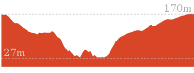
702 m
Hard track
This great walk explores much of the main ridge ridge running through Brisbane Water National Park. The walk visits a number of great lookouts and has two worthy side trips, one up to the top of Mt Wondabyne and another to the falls in Kariong Brook. The walk requires a bit of planning for transport, but is well worth a car shuffle. Allow time to relax and enjoy the views.


(0km) Patonga Wharf car park → Eastern end of Patonga Beach
530 m
10 mins
14m
-13m
Easy track
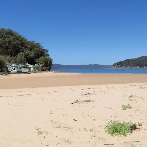
Continue straight: From the boat ramp, this walk follows the power lines across the car park, keeping the water to the right. The walk heads around the gate and continues to follow the power lines across the sand, coming to the eastern end of Patonga Beach and the ‘Brisbane Water National Park’ sign[13]. This area of the beach is also know as ‘Dark Corner’.
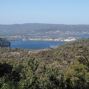
(0.53km) Eastern end of Patonga Beach → Broken Bay View
590 m
21 mins
122m
0m
Moderate track
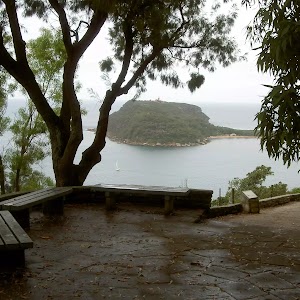
Broken Bay View

(1.12km) Broken Bay View → Warrah Lookout intersection
700 m
15 mins
26m
-26m
Moderate track
Veer right: From the intersection, this walk follows the Great North Walk arrow downhill along the wide management trail. After about 250m, the trail passes a track on the right (marked with 5 large boulders – this informal track leads to an unfenced view). The walk continues along the management trail for another 100m and comes to an intersection near the Warrah Lookout, and a sign pointing back to ‘Patonga’[17].
(1.82km) Warrah Lookout intersection → Warrah Lookout
70 m
2 mins
0m
-12m
Easy track
Warrah Lookout
(1.82km) Warrah Lookout intersection → Warrah Trig Station
310 m
7 mins
39m
0m
Easy track
Warrah Trig Station
(2.13km) Warrah Trig Station → Warrah car park
30 m
1 mins
0m
0m
Easy track
(2.16km) Warrah Car Park → Int Warrah Trig Rd trail and Warrah Trig Station Rd
310 m
5 mins
2m
-4m
Easy track
(2.47km) Int of Warrah Trig trail and Warrah Trig Station Rd → Int of Great North Walk and Patonga Dr
1.2 km
22 mins
23m
-14m
Moderate track
Veer right: From the intersection, this walk follows the GNW arrow marker around the drainage ditch[22] to follow the track running parallel to Patonga Drive (keeping the road about 20m to your left). The track leads through the heath and scribbly gum forest[23] for about 100m before passing some distant ocean views[24] (on your right), where the track continues for another 150m to come to the sealed Patonga Drive[25]. Here the walk follows the GNW arrow post[26] across the road to a locked gate and management trail[27], marked with a ‘Great North Walk’ sign[28].
(3.68km) Int of Great North Walk and Patonga Dr → Rock platform intersection
870 m
14 mins
5m
-16m
Moderate track
Veer right: From the intersection, this walk follows the ‘Girrakool’ sign[34] gently up along the wide trail. After about 200m, the trail bends left[35], then leads gently down for another 100m, coming to an intersection[36] where the main trail bends right (and with the narrower Patonga Creek trail ahead), marked with a GNW arrow post[37].
Turn right: From the intersection, this walk follows the GNW arrow post north along the wide sandy management trail. The trail leads among the heath and large scribbly gums[38] for about 270m to come to T-intersection[39] with another wide trail[40], marked with a ‘Patonga’ sign[41] pointing back up along the trail.
Turn left: From the intersection, this walk follows the ‘Girrakool’ sign[42] downhill along the management trail. Over the next 200m, the trail gently bends right then comes to an intersection (just before a large open rock platform[43]), marked with a ‘Girrakool’ sign[44] (pointing right).
(4.55km) Int of Hawkesbury track and Patonga Dr trail → Int of Hawkesbury track and Sani Depot Trail
1.1 km
21 mins
25m
-39m
Moderate track
(5.67km) Int of Hawkesbury track and Sani Depot Trail → Rock Platform
1.3 km
25 mins
21m
-56m
Moderate track
Continue straight: From the intersection, this walk follows the wide trail downhill[60], keeping the valley to your left. The trail winds downhill for almost 600m, crossing a couple of culverted creeks[61][62], until, just after a left-hand bend, this walk comes to a noteable rock platform[63] (with an ephemeral creek) and filtered view down the valley (to your left)[64].
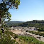
(7km) Rock Platform → Woy Woy landfill view
960 m
25 mins
77m
-39m
Hard track
Turn left: From the intersection, the walk follows the ‘Great North Walk’ sign[73] downhill along the track. After just shy of 100m, the track crosses Patonga Creek[74] among the moist cabbage palm[75] forest. Soon after crossing this creek, the track begins to head quite steeply uphill[76] for another 100m, passing a faint side track[77] before climbing up some carved steps[78] in the rock beside a sloped rock platform (on your left)[79]. The track continues steeply up for another 40m, where the track bends right (at the GNW arrow post)[80] to head over a mostly flat rock outcrop. The track continues (with occasional glimpses of the Woy Woy landfill[81]) gently uphill for just over 100m to pass another side track[82], then lead up a bit more steeply[83] for just over 100m more (past a rock wall[84], on your left) to come to an unfenced clear view over Woy Woy landfill[85] (where the track bends left[86]).
(7.96km) Woy Woy landfill view → Int of Rocky Ponds Trail and Tunnel Track
2 km
42 mins
83m
-75m
Hard track
Continue straight: From the intersection, this walk follows the GNW arrow post west[101] (in the opposite direction to the ‘Patonga’ sign[102]. After about 20m, this short track leads to an intersection with the signposted ‘Tunnel Trail’[103].
Turn right: From the intersection, this walk follows the GNW arrow post[104] gently uphill along the ‘Tunnel Trail’. After about 50m, the trail passes through a metal gate[105] and fence then continues for just over 100m to come to the signposted intersection with the ‘Rocky Ponds Trail’[106], where a ‘Patonga’ sign[107] points back down along the trail.
(9.98km) Int of Rocky Ponds Trail and Tunnel Track → Mt Wondabyne Campsite
1.2 km
25 mins
64m
-8m
Moderate track
Turn left: From the intersection, this walk follows the GNW arrow marker as well as the ‘Mt Wondabyne’[111] and ‘Girrakool’[112] signs uphill along the management trail. The trail winds up the hill for about 300m find a view of Mount Wondabyne[113] – there are also nice views behind (and to the right) across Woy Woy and the Brisbane Water[114]. The trail continues uphill for another 400m to end at a large clearing[115] (turning circle) at the base of a rock wall. This is the Mt Wondabyne Campsite[116] – there is also a sign pointing back down to ‘Patonga’[117].
Mt Wondabyne Campsite
(11.2km) Mt Wondabyne Campsite → Int of Great North Walk and Mt Wondabyne Peak tracks
90 m
2 mins
6m
0m
Moderate track
(11.29km) Int of Great North Walk and Mt Wondabyne Peak tracks → Mt Wondabyne Peak
210 m
5 mins
20m
-1m
Hard track
Mt Wondabyne
(11.29km) Int of GNW and Mt Wondabyne Peak tracks → Int of GNW and Mullet Creek Trail
950 m
21 mins
11m
-109m
Hard track
(12.23km) Int of GNW and Mullet Creek Trail → Int of GNW and Thommos Loop trail
1 km
22 mins
54m
-29m
Moderate track
Turn left: From the intersection, this walk follows the ‘Girrakool’ sign[140], heading under the power lines and down along the track to soon cross a small ephemeral creek[141]. From the creek, this walk follows a rock platform[142] for about 200m to then head over a section of timber boardwalk[143] and past a few disused power poles[144]. The track soon begins to climb and crosses a number or rock platforms[145] for about 300m to come to a notably large rock platform[146] with a wide view across the valley to Mt Wondabyne[147]. Here the track continues up for another 250m to an intersection[148] with a wide trail (at another rock platform), where a ‘Patonga’ sign[149] points back down along the track.
(13.28km) Int of GNW and Thommos Loop track → Int of the Great North Walk and Patonga service trail
1.5 km
28 mins
34m
-54m
Moderate track
(14.77km) Int of the Great North Walk and Patonga service trail → Kariong Brook crossing
690 m
24 mins
21m
-122m
Hard track
Kariong Brook Falls

(14.77km) Int of the Great North Walk and Patonga service trail → Int of Great North Walk and Woy Woy Road
1.8 km
37 mins
83m
-22m
Moderate track
Continue straight: From the rock platform, this walk heads north east along the management trail, keeping the main valley views to the left. The trail winds up the hill to come to a four-way intersection with the power line management trail and a ‘Thommas Loop’ (sign pointing back down the hill).
Continue straight: From the intersection, this walk heads up the hill following the service trail, past the National Park gate to the intersection of Woy Woy Road.
(16.59km) Int of Thommos Trail and Woy Woy Road → Staples Lookout
370 m
7 mins
13m
0m
Easy track
Staples Lookout

Maps for the Patonga to Staples Lookout walk
You can download the PDF for this walk to print a map.
These maps below cover the walk and the wider area around the walk, they are worth carrying for safety reasons.
| Gosford | 1:25 000 Map Series | 91312S GOSFORD | NSW-91312S |
| Broken Bay | 1:25 000 Map Series | 91301N BROKEN BAY | NSW-91301N |
| Ku-ring-gai Chase National Park Tourist Map | 1:40 000 Map Series | CMA Ku-ring-gai Chase National Park Tourist Map | CMA Ku-ring-gai Chase National Park Tourist Map |
| Gosford | 1:100 000 Map Series | 9131 GOSFORD | 9131 |
| Sydney | 1:100 000 Map Series | 9130 SYDNEY | 9130 |
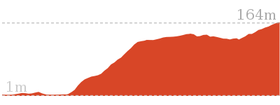
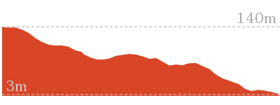
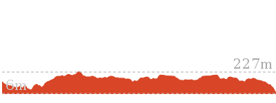
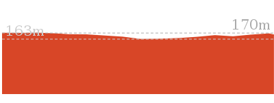
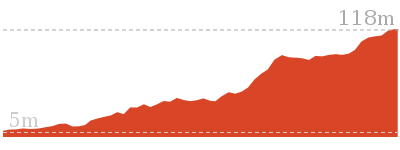
Cross sectional view of the Patonga to Staples Lookout bushwalking track
Analysis and summary of the altitude variation on the Patonga to Staples Lookout

Overview of this walks grade – based on the AS 2156.1 – 2001
Under this standard, a walk is graded based on the most difficult section of the walk.
| Length | 17 km | ||
| Time | 6 hrs 30 mins | ||
| . | |||
| Grade 4/6 Hard track |
AS 2156.1 | Gradient | Very steep (4/6) |
| Quality of track | Rough track, where fallen trees and other obstacles are likely (4/6) | ||
| Signs | Directional signs along the way (3/6) | ||
| Experience Required | Some bushwalking experience recommended (3/6) | ||
| Weather | Weather generally has little impact on safety (1/6) | ||
| Infrastructure | Limited facilities (such as cliffs not fenced, significant creeks not bridged) (4/6) |
Some more details of this walks Grading
Here is a bit more details explaining grading looking at sections of the walk
Gradient
8km of this walk has gentle hills with occasional steps and another 7km has short steep hills. Whilst another 1.3km is flat with no steps and the remaining 440m is very steep.
Quality of track
13km of this walk follows a clear and well formed track or trail and another 3.2km follows a rough track, where fallen trees and other obstacles are likely. The remaining (1.2km) follows a formed track, with some branches and other obstacles.
Signs
Around 11km of this walk has directional signs at most intersection, whilst the remaining 6km is clearly signposted.
Experience Required
Around 13km of this walk requires no previous bushwalking experience, whilst the remaining 4.1km requires some bushwalking experience.
weather
This whole walk, 17km is not usually affected by severe weather events (that would unexpectedly impact safety and navigation).
Infrastructure
11km of this walk is close to useful facilities (such as fenced cliffs and seats) and another 6km has limited facilities (such as not all cliffs fenced). The remaining (440m) has limited facilities (such as cliffs not fenced, significant creeks not bridged).
Similar walks
A list of walks that share part of the track with the Patonga to Staples Lookout walk.
756 m Return
20 mins
Easy track
2.2 km One way
1 Hr
Moderate track
2.8 km One way
1 hr 15 mins
Moderate track
4.3 km Return
2 hrs
Moderate track
4.3 km One way
1 hr 45 mins
Moderate track
5.1 km Return
2 hrs
Moderate track
5.8 km Return
2 hrs 30 mins
Hard track
10.8 km Circuit
4 hrs 30 mins
Hard track
12.3 km One way
5 hrs 30 mins
Hard track
15.4 km One way
6 hrs
Hard track
15.5 km One way
5 hrs 45 mins
Hard track
16.1 km One way
6 hrs 30 mins
Experienced only

19.5 km One way
7 hrs 30 mins
Hard track
20.7 km One way
8 hrs 30 mins
Hard track
24 km One way
8 hrs 30 mins
Experienced only
24.8 km One way
10 hrs
Hard track
24.8 km One way
2 Days
Hard track
28.1 km One way
2 Days
Experienced only
33.4 km One way
2 Days
Hard track
41.5 km One way
3 Days
Hard track
Other Nearby walks
A list of walks that start near the Patonga to Staples Lookout walk.
931 m Circuit
30 mins
Moderate track
1.4 km Return
30 mins
Very easy
18.1 km Return
8 hrs
Hard track
1.4 km Return
30 mins
Easy track
2.8 km Circuit
1 hr 30 mins
Very experienced only
2.1 km Return
1 Hr
Moderate track
1.9 km Return
1 Hr
Hard track
1.1 km Circuit
45 mins
Moderate track
3.7 km Return
1 hr 30 mins
Hard track
3.5 km Circuit
1 hr 45 mins
Hard track
1.9 km Return
1 Hr
Moderate track
403 m Circuit
30 mins
Moderate track
Plan your trip to and from the walk here
The Patonga to Staples Lookout walk starts at the Patonga Wharf car park (gps: -33.55043, 151.27456)
Your transport options to Patonga Wharf car park are by;
![]() Ferry. Ferry service operates between Palm Beach and Bobbin head daily. Stopping at Patoonga Beach (and Cottage Point on request).
Ferry. Ferry service operates between Palm Beach and Bobbin head daily. Stopping at Patoonga Beach (and Cottage Point on request).
Mon – Fri once a day (before lunch)
Weekends and school holidays 3 times a day from Bobbin Head.
(can get also get it later on the way to palm beach on request)
Phone to confirm times on the day 0414466635 (get details)
![]() Ferry. There is no regular ferry service between Patonga and Brooklyn any more. You can easily grab a water taxi (about +). If you are part of a large group they can also organise a larger boat carrying 35 passengers (about pp). Phone 0410 554 777 to book. Enjoy the boat ride. (get details)
Ferry. There is no regular ferry service between Patonga and Brooklyn any more. You can easily grab a water taxi (about +). If you are part of a large group they can also organise a larger boat carrying 35 passengers (about pp). Phone 0410 554 777 to book. Enjoy the boat ride. (get details)
![]() Bus. A bus service runs along Patonga Drive down to Patonga. The service only runs a few times a day. Please check timetable for more info or Phone Busway on (02) 4368 2277 (route 50) (get details)
Bus. A bus service runs along Patonga Drive down to Patonga. The service only runs a few times a day. Please check timetable for more info or Phone Busway on (02) 4368 2277 (route 50) (get details)
![]() Car. There is free parking available.
Car. There is free parking available.
(get details)
The Patonga to Staples Lookout ends at the Staples Lookout (gps: -33.471741, 151.2883)
Your main transport option to Staples Lookout is by;
![]() Car. There is free parking available.
Car. There is free parking available.
(get details)
Short URL = http://wild.tl/ptsl
Gallery images
There are other downloads I am still working on.
You will probably need to login to access these — still all free.
* KML (google earth file)
* GPX (GPS file)
Special Maps/ brochures
* A3 topo maps
* PDF with Lands Topo map base
* PDF with arial image (and map overlay)
I wanted to get the main site live first, this extra stuff will come in time.
Happy walking
Matt 🙂
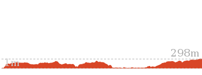
Girrakool to Wondabyne station via Pindar caves

7 hrs 30 mins
741 m
Experienced only
This walk starts from the Girrakool picnic area and winds south, following Piles creek into the Brisbane Waters National Park. The walk crosses over Scopas Peak and continues down to Pindar caves, passing the Pindar lookout and Pindar Pool on the way. From the caves the walk backtracks some distance, before winding down to the Wondabyne train station. * This walk passes through very remote areas and sections have no visible track. At least one person in your group should have training and experience in off track walking and navigation. Even with these notes and a GPS these extra skills and equipment are required.
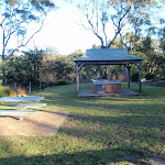


Girrakool Picnic Area
(0km) Girrakool picnic area car park → Illoura Lookout
270 m
6 mins
0m
-33m
Easy track
Continue straight: From the intersection, this walk follows the ‘Girrakool Loop’ sign down along the stone path. The path soon heads down some steps and comes to a fenced and signposted ‘Illoura Lookout’.
Illoura Lookout
(0.27km) Illoura Lookout → Int of Girrakool and Piles Ck lookout tracks
1.1 km
27 mins
47m
-83m
Moderate track
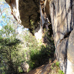
Veer left: From the top of Piles Creek waterfall, this walk follows the track heading south away from the waterfall (keeping the big valley to the right). The clear track winds through the thick bush crossing a few small tributaries and though four sandstone caves. The caves provide good shelter and a great spot to rest. The track then flattens out and comes to a 3-way intersection and a ‘Girrakool’ sign.
Continue straight: From the intersection, the walk heads south along the wide track in the opposite direction of the ‘Girrakool’ sign. Soon the track heads down a short wooden staircase to the intersection at the bottom (Piles Creek Lookout visible to the right).
(1.38km) Int of Girrakool and Piles Ck lookout tracks → Monolith Cave
80 m
2 mins
16m
0m
Moderate track
Monolith Cave
(1.46km) Monolith Cave → Rat Gully Lookout
220 m
7 mins
13m
-29m
Moderate track
(1.68km) Rat Gully Lookout → Tributary Crossing
1 km
29 mins
96m
-81m
Hard track
Turn sharp left: From the intersection, this walk follows the ‘Patonga Ferry’ sign[3] up the side of the gully, keeping the intermittent creek[4] to your left. The track leads past a ‘Patonga’ sign then winds steeply up the hill for about 130m, through a cleft in the rock[5] and past a few rock walls, and then the track mostly flattens out with some filtered distant views[6]. The track continues gently uphill for another 300m, becoming progressively flatter[7] before passing along the side of a long rock wall[8], with a tall sandstone overhang[9]. The track then crosses a small gully and leads past another overhang, where the track begins to lead downhill. The rocky track winds steeply downhill for about 130m to then cross an intermittent creek which flows over the solid sandstone platform[10].
(2.69km) Tributary Crossing → Scopas Peak
2.4 km
57 mins
189m
-33m
Hard track
(5.11km) Scopas Peak → South end of Scopas Peak Track
1.2 km
23 mins
14m
-80m
Hard track
Continue straight: From the Great North Walk intentions book[29], after leaving your comments, this walk heads south, gently downhill[30] along the clear track. After about 150m, the walk comes to a T-intersection[31] with the Gosford Rifle Range trail – At this intersection is a ‘Girrakool’ sign[32], pointing back along the track.
(6.27km) Int of GNW and Gosford Rifle Range trail → Int of GNW and Wondabyne trail
1.1 km
22 mins
40m
-27m
Moderate track
(7.4km) Int of GNW and Wondabyne Station tracks → Eastern end of the Pindar Cave Track
630 m
11 mins
5m
-19m
Moderate track
(8.02km) Int. Rifle Range Service Track and Pindar Cave Track → Mt Pindar Lookout
3.5 km
1 hr 12 mins
129m
-129m
Hard track
Mt Pindar lookout
(11.52km) Mt Pindar Lookout → Pool
480 m
9 mins
2m
-25m
Experienced only
Pindar Pool
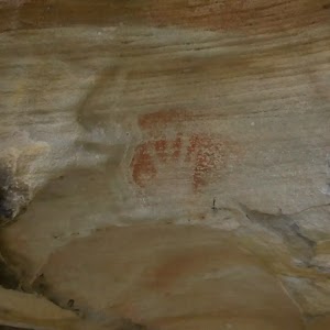
(12km) Pool → Pindar Cave
320 m
6 mins
12m
-6m
Experienced only
Pindar Cave
(12.32km) Pindar Cave → Waterfall
570 m
12 mins
10m
-57m
Very experienced only
Pindar Waterfall
(12.32km) Pindar Cave → Mt Pindar Lookout
800 m
15 mins
31m
-14m
Experienced only
Turn right: From the pool, the walk follows the bush track east, out of the clearing. The track passes through an area of thick vegetation as is slowly climbs up the spur, before the vegetation gives way to a rocky area. The track winds further up the hill and along the ridge edge to the lookout.
(13.12km) Mt Pindar Lookout → Int. Rifle Range Service Track and Pindar Cave Track
3.5 km
1 hr 12 mins
129m
-129m
Hard track
(16.61km) Eastern end of the Pindar Cave Track → Clearing above Wondabyne Station
1 km
19 mins
3m
-72m
Hard track
(17.65km) Clearing above Wondabyne Station → Wondabyne Station
440 m
13 mins
15m
-100m
Hard track
Wondabyne
Maps for the Girrakool to Wondabyne station via Pindar caves walk
You can download the PDF for this walk to print a map.
These maps below cover the walk and the wider area around the walk, they are worth carrying for safety reasons.
| Gunderman | 1:25 000 Map Series | 91313S GUNDERMAN | NSW-91313S |
| Gosford | 1:25 000 Map Series | 91312S GOSFORD | NSW-91312S |
| Gosford | 1:100 000 Map Series | 9131 GOSFORD | 9131 |
Cross sectional view of the Girrakool to Wondabyne station via Pindar caves bushwalking track
Analysis and summary of the altitude variation on the Girrakool to Wondabyne station via Pindar caves
Overview of this walks grade – based on the AS 2156.1 – 2001
Under this standard, a walk is graded based on the most difficult section of the walk.
| Length | 18.1 km | ||
| Time | 7 hrs 30 mins | ||
| . | |||
| Grade 5/6 Experienced only |
AS 2156.1 | Gradient | Very steep (4/6) |
| Quality of track | Rough unclear track (5/6) | ||
| Signs | No directional signs (5/6) | ||
| Experience Required | Moderate level of bushwalking experience recommended (4/6) | ||
| Weather | Storms may impact on navigation and safety (3/6) | ||
| Infrastructure | Limited facilities (such as cliffs not fenced, significant creeks not bridged) (4/6) |
Some more details of this walks Grading
Here is a bit more details explaining grading looking at sections of the walk
Gradient
14km of this walk is very steep and another 2.6km has short steep hills. Whilst another 1.7km has gentle hills with occasional steps and the remaining 130m is flat with no steps.
Quality of track
9km of this walk follows a rough track, where fallen trees and other obstacles are likely and another 4km follows a clear and well formed track or trail. Whilst another 3km follows a formed track, with some branches and other obstacles and the remaining 1.6km follows a rough unclear track.
Signs
9km of this walk has minimal directional signs and another 6km has directional signs at most intersection. Whilst another 1.6km Has no directional signs and the remaining 630m is clearly signposted.
Experience Required
14km of this walk requires some bushwalking experience and another 2.3km requires no previous bushwalking experience. The remaining (1.6km) requires a leader a with moderate level of bushwalking experience.
weather
Around 17km of this walk is not usually affected by severe weather events (that would unexpectedly impact safety and navigation), whilst the remaining 970m is affected by storms that may impact your navigation and safety.
Infrastructure
9km of this walk has limited facilities (such as cliffs not fenced, significant creeks not bridged) and another 4.9km has limited facilities (such as not all cliffs fenced). The remaining (4.6km) is close to useful facilities (such as fenced cliffs and seats).
Similar walks
A list of walks that share part of the track with the Girrakool to Wondabyne station via Pindar caves walk.
803 m Circuit
20 mins
Moderate track
1.1 km Circuit
30 mins
Moderate track
1.4 km Circuit
45 mins
Moderate track
4.2 km Circuit
2 hrs
Moderate track
8.1 km Return
3 hrs 30 mins
Hard track
9.5 km One way
4 hrs
Hard track
10.1 km One way
4 hrs 15 mins
Hard track
11.5 km Return
6 hrs
Experienced only
12.3 km One way
5 hrs 30 mins
Hard track
15.4 km One way
6 hrs
Hard track
19.5 km One way
7 hrs 30 mins
Hard track
20 km Circuit
7 hrs 30 mins
Moderate track
20.7 km One way
8 hrs 30 mins
Hard track
24 km One way
8 hrs 30 mins
Experienced only
24.8 km One way
10 hrs
Hard track
24.8 km One way
2 Days
Hard track
26.2 km One way
10 hrs
Hard track
26.2 km One way
2 Days
Hard track
28.1 km One way
2 Days
Experienced only
33.4 km One way
2 Days
Hard track
41.5 km One way
3 Days
Hard track
Other Nearby walks
A list of walks that start near the Girrakool to Wondabyne station via Pindar caves walk.
378 m Return
10 mins
Easy track
16.1 km One way
6 hrs
Hard track

800 m Return
20 mins
Very easy
426 m Return
20 mins
Moderate track
991 m One way
30 mins
Moderate track
1.7 km Circuit
45 mins
Moderate track

3 km Return
1 hr 30 mins
Hard track
2.2 km One way
1 Hr
Hard track
3 km One way
1 hr 30 mins
Hard track
2.1 km Circuit
1 hr 15 mins
Hard track

6.1 km Circuit
2 hrs 45 mins
Hard track
11.3 km One way
4 hrs 30 mins
Hard track
Plan your trip to and from the walk here
The Girrakool to Wondabyne station via Pindar caves walk starts at the Girrakool picnic area car park (gps: -33.43168, 151.2766)
Your main transport option to Girrakool picnic area car park is by;
![]() Car. A park entry fee is required for driving into the park.
Car. A park entry fee is required for driving into the park.
(get details)
The Girrakool to Wondabyne station via Pindar caves ends at the Wondabyne Station (gps: -33.492083, 151.25696)
Your main transport option to Wondabyne Station is by;
![]() Train. (get details)
Train. (get details)
Important Note: There is no car transport option to the end of this walk.
Short URL = http://wild.tl/gtwsvpc
Gallery images
There are other downloads I am still working on.
You will probably need to login to access these — still all free.
* KML (google earth file)
* GPX (GPS file)
Special Maps/ brochures
* A3 topo maps
* PDF with Lands Topo map base
* PDF with arial image (and map overlay)
I wanted to get the main site live first, this extra stuff will come in time.
Happy walking
Matt 🙂
Little Wobby to Rocky Ponds
And Walk
Little Wobby to Rocky Ponds

8 hrs
923 m
Hard track
This great walk starts from Brooklyn with a ferry trip to Little Wobby and explores some fantastic panoramic views of the Hawkesbury River and Tank Creek. The alternate route, for more experienced walkers, cuts a fair bit of walking and gets you to the views quicker. The views along the ridge are great and the Tumblecow2 flat rock makes a lovely rest spot. From here, much of the walk is through heath until arriving at the picturesque Rocky Ponds on Tanks Creek. There is a campsite for people wanting more time to explore before walking back.


Permit Required
(0km) Brooklyn Ferry Terminal → Little Wobby Wharf
3.1 km
20 mins
8m
-4m
Easy track
Alternatively, you can catch a water taxi, which generally costs about $100 per group of 4 and needs to be booked ahead. There are a few options – try Hawkesbury River Water Taxi on 0400 600 111 or Rick on 0448 101 010. More info.
Little Wobby
(3.08km) Little Wobby Beach Wharf → Little Wobby Sport and Rec Wharf
400 m
9 mins
20m
-22m
Easy track
(3.48km) Little Wobby Sport and Rec Wharf → Int of Pacific Trail and Defile Track
870 m
19 mins
43m
-38m
Easy track
Spring Beach
(4.35km) Int of Pacific Trail and Defile Track → Int of Midway trail and The Defile
740 m
18 mins
131m
-6m
Experienced only
(4.35km) Int of Pacific Trail and Defile Track → Juno Head Intersection
1.6 km
35 mins
76m
-62m
Easy track
Continue straight: From the intersection, keeping the water views to the right, this walk heads gently up hill along the management trail, soon passing an old toilet. The trail winds along the hill for a while (passing an old trail on the left just after the white posts), soon coming to and passing a green concrete pumping station (Forty Year Spring). About 650m past the spring, the trail passes the signposted ‘Rock Climbing’ track and then comes to an intersection just above the signposted ‘Juno Head Campsite’.
(5.93km) Juno Head Intersection → Int of Midway and Pacific Trails
270 m
7 mins
17m
-20m
Easy track
(6.2km) Int of Midway and Pacific Trails → Tessellated Pavement
1.4 km
32 mins
144m
-12m
Hard track
Veer left: From the intersection and campsite, this walk follows the red and yellow marker north-west along the track. The track follows the ridge top, with the occasional clearing giving great views of the Hawkesbury River on the left. The red and yellow markers lead through a cleft in the rocks then up through a small gully in a rocky outcrop, then the walk comes to a fairly large tessellated rock platform (surround by heath, this is also the intersection with the unsignposted, yellow marker, Horseshoe trail).
Tessellated Pavement
(7.59km) Tessellated Pavement → Int of Midway trail and The Defile
450 m
10 mins
13m
-33m
Hard track
(8.04km) Int of Midway trail and The Defile → Tumblecow 2 flat rock
1.2 km
28 mins
64m
-78m
Hard track
Veer right: From the intersection, this walk heads north, passing under the power lines and past the telegraph poles. The track heads through the scrub for a while before passing a few nice vantage points with great views over Brooklyn, then coming to a view with two TV antennas mounted on small masts. The track continues along the top of the ridge for another 350m, passing some more great views and coming to two more TV antennas on a another rocky outcrop. About 70m past these antennas, the track comes to a large flat rock platform with two more TV antennas and great views over Brooklyn and the Hawkesbury River.
Tumblecow 2 flat rock
(9.19km) Tumblecow 2 flat rock → Tank Creek Crossing
2.6 km
57 mins
99m
-154m
Hard track
Rocky Ponds
(11.79km) Tank Creek Crossing → Tank Creek Campsite
90 m
2 mins
8m
0m
Hard track
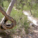
Continue straight: From the gully, this walk steps up, passing the tree with exposed roots. The track leads north through the scrub to a open clearing, then turns right to head another 30m to a larger clearing and campsite. At the end of this side trip, retrace your steps back to the main walk then Turn right.
Tank Creek Campsite
(11.79km) Tank Creek Crossing → Jeannie’s Pool intersection
220 m
4 mins
1m
-12m
Hard track
(12.01km) Jeannie’s Pool intersection → Jeannie’s Pool
10 m
0m
0m
Hard track
Jeannie’s Pool
(12.01km) Rocky Ponds Pool intersection → Tank Creek last fall
140 m
3 mins
0m
-15m
Hard track
Tank Creek last fall
(12.15km) Tank Creek last fall → The Icicles
180 m
5 mins
20m
-14m
Experienced only
Maps for the Little Wobby to Rocky Ponds walk
You can download the PDF for this walk to print a map.
These maps below cover the walk and the wider area around the walk, they are worth carrying for safety reasons.
| Cowan | 1:25 000 Map Series | 91304N COWAN | NSW-91304N |
| Broken Bay | 1:25 000 Map Series | 91301N BROKEN BAY | NSW-91301N |
| Ku-ring-gai Chase National Park Tourist Map | 1:40 000 Map Series | CMA Ku-ring-gai Chase National Park Tourist Map | CMA Ku-ring-gai Chase National Park Tourist Map |
| Sydney | 1:100 000 Map Series | 9130 SYDNEY | 9130 |
Cross sectional view of the Little Wobby to Rocky Ponds bushwalking track
Analysis and summary of the altitude variation on the Little Wobby to Rocky Ponds
Overview of this walks grade – based on the AS 2156.1 – 2001
Under this standard, a walk is graded based on the most difficult section of the walk.
| Length | 18.1 km | ||
| Time | 8 hrs | ||
| . | |||
| Grade 4/6 Hard track |
AS 2156.1 | Gradient | Short steep hills (3/6) |
| Quality of track | Rough track, where fallen trees and other obstacles are likely (4/6) | ||
| Signs | Minimal directional signs (4/6) | ||
| Experience Required | Some bushwalking experience recommended (3/6) | ||
| Weather | Forecast, unforecast storms and severe weather may impact on navigation and safety (4/6) | ||
| Infrastructure | Limited facilities (such as cliffs not fenced, significant creeks not bridged) (4/6) |
Some more details of this walks Grading
Here is a bit more details explaining grading looking at sections of the walk
Gradient
6km of this walk has short steep hills and another 3.5km is flat with no steps. The remaining (2.7km) has gentle hills with occasional steps.
Quality of track
6km of this walk follows a clear and well formed track or trail and another 6km follows a rough track, where fallen trees and other obstacles are likely. The remaining (360m) follows a formed track, with some branches and other obstacles.
Signs
6km of this walk is clearly signposted and another 5km has minimal directional signs. The remaining (550m) has directional signs at most intersection.
Experience Required
Around 7km of this walk requires no previous bushwalking experience, whilst the remaining 5km requires some bushwalking experience.
weather
9km of this walk is not usually affected by severe weather events (that would unexpectedly impact safety and navigation) and another 2.6km is affected by forecast, unforecast storms and severe weather events that may impact on navigation and safety. The remaining (220m) is affected by storms that may impact your navigation and safety.
Infrastructure
7km of this walk is close to useful facilities (such as fenced cliffs and seats) and another 4.4km has limited facilities (such as cliffs not fenced, significant creeks not bridged). The remaining (990m) has limited facilities (such as not all cliffs fenced).
Similar walks
A list of walks that share part of the track with the Little Wobby to Rocky Ponds walk.
16.1 km One way
6 hrs 30 mins
Experienced only
Other Nearby walks
A list of walks that start near the Little Wobby to Rocky Ponds walk.
931 m Circuit
30 mins
Moderate track
1.4 km Return
30 mins
Very easy
4.3 km One way
1 hr 45 mins
Moderate track
41.5 km One way
3 Days
Hard track
17 km One way
6 hrs 30 mins
Hard track
19.5 km One way
7 hrs 30 mins
Hard track
28.1 km One way
2 Days
Experienced only
4.3 km Return
2 hrs
Moderate track
15.5 km One way
5 hrs 45 mins
Hard track
2.2 km One way
1 Hr
Moderate track
2.8 km One way
1 hr 15 mins
Moderate track
756 m Return
20 mins
Easy track
Plan your trip to and from the walk here
The Little Wobby to Rocky Ponds walk starts and ends at the Brooklyn Ferry Terminal (gps: -33.546533, 151.22724)
Your transport options to Brooklyn Ferry Terminal are by;
![]() Train. (get details)
Train. (get details)
![]() Car. There is free parking available.
Car. There is free parking available.
(get details)
Short URL = http://wild.tl/rpflw
Gallery images
There are other downloads I am still working on.
You will probably need to login to access these — still all free.
* KML (google earth file)
* GPX (GPS file)
Special Maps/ brochures
* A3 topo maps
* PDF with Lands Topo map base
* PDF with arial image (and map overlay)
I wanted to get the main site live first, this extra stuff will come in time.
Happy walking
Matt 🙂
Patonga to Wondabyne station via Mt Wondabyne

7 hrs 30 mins
861 m
Hard track
This walk explores some grand views, pleasant cascades, varied bushland and remote areas of Brisbane Waters National Park. From Patonga you will walk up the ridge and take a short side trip to enjoy the wonderful views from Warrah Lookout, before following a series of dirt roads and management trails to Patonga Creek in the heart of the national park. The walk then leads along a mix of trails and tracks mostly passing Mt Wondabyne, a worthwhile side trip, before crossing a few gullies with cool creeks and cascades. Past Myron Brook you will walk back down the waters edge at the remote and unique Wondabyne Train Station.


(0km) Patonga Wharf car park → Eastern end of Patonga Beach
530 m
10 mins
14m
-13m
Easy track
Continue straight: From the boat ramp, this walk follows the power lines across the car park, keeping the water to the right. The walk heads around the gate and continues to follow the power lines across the sand, coming to the eastern end of Patonga Beach and the ‘Brisbane Water National Park’ sign[13]. This area of the beach is also know as ‘Dark Corner’.
(0.53km) Eastern end of Patonga Beach → Broken Bay View
590 m
21 mins
122m
0m
Moderate track
Broken Bay View
(1.12km) Broken Bay View → Warrah Lookout intersection
700 m
15 mins
26m
-26m
Moderate track
Veer right: From the intersection, this walk follows the Great North Walk arrow downhill along the wide management trail. After about 250m, the trail passes a track on the right (marked with 5 large boulders – this informal track leads to an unfenced view). The walk continues along the management trail for another 100m and comes to an intersection near the Warrah Lookout, and a sign pointing back to ‘Patonga’[17].
(1.82km) Warrah Lookout intersection → Warrah Lookout
70 m
2 mins
0m
-12m
Easy track
Warrah Lookout
(1.82km) Warrah Lookout intersection → Warrah Trig Station
310 m
7 mins
39m
0m
Easy track
Warrah Trig Station
(2.13km) Warrah Trig Station → Warrah car park
30 m
1 mins
0m
0m
Easy track
(2.16km) Warrah Car Park → Int of Warrah Trig Station Rd and Patonga Drive track
1.2 km
22 mins
22m
-12m
Easy track
Continue straight: From the intersection, this walk follows the dirt road north up a long and gentle hill. The road leads to an intersection with a track on the right marked with a Great North Walk arrow about 30m before Patonga Drive.
(3.41km) Int of Warrah Trig Station Rd and Patonga Drive track → Int of Great North Walk and Patonga Dr
280 m
5 mins
3m
-6m
Moderate track
(3.68km) Int of Great North Walk and Patonga Dr → Int of Rest Area and Girrakool tracks
120 m
2 mins
0m
-4m
Easy track
(3.81km) Int of Rest Area and Girrakool tracks → Rest Area
210 m
3 mins
1m
-7m
Moderate track
Patonga rest area
(3.81km) Int of Rest Area and Girrakool tracks → Int of Patonga and Girrakool tracks
550 m
9 mins
5m
-6m
Moderate track
Turn right: From the intersection, this walk follows the GNW arrow post north along the wide sandy management trail. The trail leads among the heath and large scribbly gums[41] for about 270m to come to T-intersection[42] with another wide trail[43], marked with a ‘Patonga’ sign[44] pointing back up along the trail.
(4.36km) Int of Hawkesbury track and Patonga Dr trail → Int of Hawkesbury track and Sani Depot Trail
1.3 km
24 mins
25m
-45m
Moderate track
Turn right: From the intersection, this walk follows the ‘Girrakool’ sign[48] east uphill along the management trail[49]. The trail leads up the hill for about 25m to head over a short rock platform[50] where the trail continues fairly steeply uphill. The trail bends left[51] and then winds gently around the side of the hill[52], enjoying some views[53] along the way. The trail undulates for a while before leading gently down to pass a large clearing[54] (on your left). Just past this clearing, the trail heads down (fairly steeply at first) for about 200m to enter a tall wooded forest and come to a clear three-way intersection, marked with a ‘Sani Depot Trail’ sign[55] (on your right).
(5.67km) Int of Hawkesbury track and Sani Depot Trail → Int of Hawkesbury track and Van Dahls rest area track
750 m
13 mins
2m
-32m
Moderate track
(6.41km) Int of Hawkesbury track and Van Dahls rest area track → Van Dahls rest area
160 m
3 mins
0m
-13m
Hard track
Van Dahls rest area
(6.41km) Int of Hawkesbury track and Van Dahls rest area track → Rock Platform
590 m
12 mins
19m
-24m
Moderate track
(7km) Rock Platform → Int of Hawkesbury track near Patonga Creek
520 m
12 mins
24m
-27m
Moderate track
(7.52km) Int of Hawkesbury track near Patonga Creek → Woy Woy landfill view
440 m
13 mins
53m
-12m
Hard track
(7.96km) Woy Woy landfill view → Int of Hawkesbury Track and Dillons Trail
1.8 km
39 mins
75m
-74m
Hard track
(9.79km) Int of Hawkesbury Track and Dillons Trail → Int of Tunnel Track and Mt Wondabyne trail
650 m
12 mins
23m
-9m
Moderate track
Turn right: From the intersection, this walk follows the GNW arrow post[112] gently uphill along the ‘Tunnel Trail’. After about 50m, the trail passes through a metal gate[113] and fence then continues for just over 100m to come to the signposted intersection with the ‘Rocky Ponds Trail’[114], where a ‘Patonga’ sign[115] points back down along the trail.
Continue straight: From the intersection, this walk follows the GNW arrow marker and the ‘Girrakool’ sign[116] north, gently uphill along the wide trail. The trail winds along the side of the hill for just over 450m, to come to a small crest[117] and a clear three-way intersection with the signposted ‘Mt Wondabyne’ trail[118] (on the left).
(10.44km) Int of Tunnel Track and Mt Wondabyne trail → Mt Wondabyne Campsite
760 m
16 mins
49m
0m
Moderate track
Mt Wondabyne Campsite
(11.2km) Mt Wondabyne Campsite → Int of Great North Walk and Mt Wondabyne Peak tracks
90 m
2 mins
6m
0m
Moderate track
(11.29km) Int of Great North Walk and Mt Wondabyne Peak tracks → Mt Wondabyne Peak
210 m
5 mins
20m
-1m
Hard track
Mt Wondabyne
(11.29km) Int of GNW and Mt Wondabyne Peak tracks → Int of GNW and Mullet Creek Trail
950 m
21 mins
11m
-109m
Hard track
(12.23km) Int of GNW and Mullet Creek Trail → Int of GNW and Thommos Loop trail
1 km
22 mins
54m
-29m
Moderate track
Turn left: From the intersection, this walk follows the ‘Girrakool’ sign[148], heading under the power lines and down along the track to soon cross a small ephemeral creek[149]. From the creek, this walk follows a rock platform[150] for about 200m to then head over a section of timber boardwalk[151] and past a few disused power poles[152]. The track soon begins to climb and crosses a number or rock platforms[153] for about 300m to come to a notably large rock platform[154] with a wide view across the valley to Mt Wondabyne[155]. Here the track continues up for another 250m to an intersection[156] with a wide trail (at another rock platform), where a ‘Patonga’ sign[157] points back down along the track.
(13.28km) Int of GNW and Thommos Loop track → Int of the Great North Walk and Patonga service trail
1.5 km
28 mins
34m
-54m
Moderate track
(14.77km) Int of the Great North Walk and Patonga service trail → Kariong Brook crossing
690 m
24 mins
21m
-122m
Hard track
Kariong Brook Falls
(15.45km) Kariong Brook crossing → Myron Brook crossing
400 m
11 mins
33m
-28m
Hard track
(15.86km) Myron Brook crossing → Int of GNW and Wondabyne Station Trail
1.6 km
36 mins
178m
-36m
Hard track
(17.42km) Int of GNW and Wondabyne Station tracks → Eastern end of the Pindar Cave Track
630 m
11 mins
5m
-19m
Moderate track
(18.05km) Eastern end of the Pindar Cave Track → Clearing above Wondabyne Station
1 km
19 mins
3m
-72m
Hard track
(19.08km) Clearing above Wondabyne Station → Wondabyne Station
440 m
13 mins
15m
-100m
Hard track
Wondabyne
Maps for the Patonga to Wondabyne station via Mt Wondabyne walk
You can download the PDF for this walk to print a map.
These maps below cover the walk and the wider area around the walk, they are worth carrying for safety reasons.
| Gosford | 1:25 000 Map Series | 91312S GOSFORD | NSW-91312S |
| Broken Bay | 1:25 000 Map Series | 91301N BROKEN BAY | NSW-91301N |
| Ku-ring-gai Chase National Park Tourist Map | 1:40 000 Map Series | CMA Ku-ring-gai Chase National Park Tourist Map | CMA Ku-ring-gai Chase National Park Tourist Map |
| Gosford | 1:100 000 Map Series | 9131 GOSFORD | 9131 |
| Sydney | 1:100 000 Map Series | 9130 SYDNEY | 9130 |
Cross sectional view of the Patonga to Wondabyne station via Mt Wondabyne bushwalking track
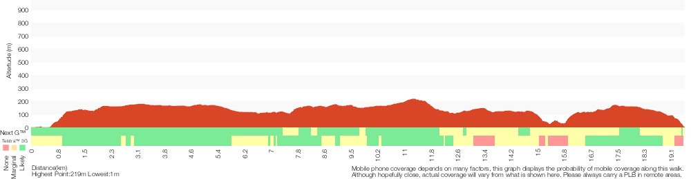
Analysis and summary of the altitude variation on the Patonga to Wondabyne station via Mt Wondabyne

Overview of this walks grade – based on the AS 2156.1 – 2001
Under this standard, a walk is graded based on the most difficult section of the walk.
| Length | 19.5 km | ||
| Time | 7 hrs 30 mins | ||
| . | |||
| Grade 4/6 Hard track |
AS 2156.1 | Gradient | Very steep (4/6) |
| Quality of track | Rough track, where fallen trees and other obstacles are likely (4/6) | ||
| Signs | Minimal directional signs (4/6) | ||
| Experience Required | Some bushwalking experience recommended (3/6) | ||
| Weather | Storms may impact on navigation and safety (3/6) | ||
| Infrastructure | Limited facilities (such as cliffs not fenced, significant creeks not bridged) (4/6) |
Some more details of this walks Grading
Here is a bit more details explaining grading looking at sections of the walk
Gradient
7km of this walk has short steep hills and another 7km has gentle hills with occasional steps. Whilst another 4.2km is very steep and the remaining 1.3km is flat with no steps.
Quality of track
12km of this walk follows a clear and well formed track or trail and another 6km follows a rough track, where fallen trees and other obstacles are likely. The remaining (1.7km) follows a formed track, with some branches and other obstacles.
Signs
14km of this walk has directional signs at most intersection and another 4.4km is clearly signposted. The remaining (1.1km) has minimal directional signs.
Experience Required
Around 12km of this walk requires no previous bushwalking experience, whilst the remaining 8km requires some bushwalking experience.
weather
Around 19km of this walk is not usually affected by severe weather events (that would unexpectedly impact safety and navigation), whilst the remaining 690m is affected by storms that may impact your navigation and safety.
Infrastructure
12km of this walk is close to useful facilities (such as fenced cliffs and seats) and another 7km has limited facilities (such as not all cliffs fenced). The remaining (440m) has limited facilities (such as cliffs not fenced, significant creeks not bridged).
Similar walks
A list of walks that share part of the track with the Patonga to Wondabyne station via Mt Wondabyne walk.
756 m Return
20 mins
Easy track
2.2 km One way
1 Hr
Moderate track
2.8 km One way
1 hr 15 mins
Moderate track
4.3 km Return
2 hrs
Moderate track
4.3 km One way
1 hr 45 mins
Moderate track
5.1 km Return
2 hrs
Moderate track
5.8 km Return
2 hrs 30 mins
Hard track
8.1 km Return
3 hrs 30 mins
Hard track
9.5 km One way
4 hrs
Hard track
10.1 km One way
4 hrs 15 mins
Hard track
10.8 km Circuit
4 hrs 30 mins
Hard track
11.5 km Return
6 hrs
Experienced only
12.3 km One way
5 hrs 30 mins
Hard track
15.4 km One way
6 hrs
Hard track
15.5 km One way
5 hrs 45 mins
Hard track
16.1 km One way
6 hrs 30 mins
Experienced only
17 km One way
6 hrs 30 mins
Hard track
18.1 km One way
7 hrs 30 mins
Experienced only
20.7 km One way
8 hrs 30 mins
Hard track
24 km One way
8 hrs 30 mins
Experienced only
24.8 km One way
10 hrs
Hard track
24.8 km One way
2 Days
Hard track
26.2 km One way
10 hrs
Hard track
26.2 km One way
2 Days
Hard track
28.1 km One way
2 Days
Experienced only
33.4 km One way
2 Days
Hard track
41.5 km One way
3 Days
Hard track
Other Nearby walks
A list of walks that start near the Patonga to Wondabyne station via Mt Wondabyne walk.
931 m Circuit
30 mins
Moderate track
1.4 km Return
30 mins
Very easy
18.1 km Return
8 hrs
Hard track
1.4 km Return
30 mins
Easy track
2.8 km Circuit
1 hr 30 mins
Very experienced only
2.1 km Return
1 Hr
Moderate track
1.9 km Return
1 Hr
Hard track
1.1 km Circuit
45 mins
Moderate track
3.7 km Return
1 hr 30 mins
Hard track
3.5 km Circuit
1 hr 45 mins
Hard track
1.9 km Return
1 Hr
Moderate track
403 m Circuit
30 mins
Moderate track
Plan your trip to and from the walk here
The Patonga to Wondabyne station via Mt Wondabyne walk starts at the Patonga Wharf car park (gps: -33.55043, 151.27456)
Your transport options to Patonga Wharf car park are by;
![]() Ferry. Ferry service operates between Palm Beach and Bobbin head daily. Stopping at Patoonga Beach (and Cottage Point on request).
Ferry. Ferry service operates between Palm Beach and Bobbin head daily. Stopping at Patoonga Beach (and Cottage Point on request).
Mon – Fri once a day (before lunch)
Weekends and school holidays 3 times a day from Bobbin Head.
(can get also get it later on the way to palm beach on request)
Phone to confirm times on the day 0414466635 (get details)
![]() Ferry. There is no regular ferry service between Patonga and Brooklyn any more. You can easily grab a water taxi (about +). If you are part of a large group they can also organise a larger boat carrying 35 passengers (about pp). Phone 0410 554 777 to book. Enjoy the boat ride. (get details)
Ferry. There is no regular ferry service between Patonga and Brooklyn any more. You can easily grab a water taxi (about +). If you are part of a large group they can also organise a larger boat carrying 35 passengers (about pp). Phone 0410 554 777 to book. Enjoy the boat ride. (get details)
![]() Bus. A bus service runs along Patonga Drive down to Patonga. The service only runs a few times a day. Please check timetable for more info or Phone Busway on (02) 4368 2277 (route 50) (get details)
Bus. A bus service runs along Patonga Drive down to Patonga. The service only runs a few times a day. Please check timetable for more info or Phone Busway on (02) 4368 2277 (route 50) (get details)
![]() Car. There is free parking available.
Car. There is free parking available.
(get details)
The Patonga to Wondabyne station via Mt Wondabyne ends at the Wondabyne Station (gps: -33.492083, 151.25696)
Your main transport option to Wondabyne Station is by;
![]() Train. (get details)
Train. (get details)
Important Note: There is no car transport option to the end of this walk.
Short URL = http://wild.tl/ptwsvmw
Gallery images
There are other downloads I am still working on.
You will probably need to login to access these — still all free.
* KML (google earth file)
* GPX (GPS file)
Special Maps/ brochures
* A3 topo maps
* PDF with Lands Topo map base
* PDF with arial image (and map overlay)
I wanted to get the main site live first, this extra stuff will come in time.
Happy walking
Matt 🙂
Somersby & Mooney Mooney Creek Loop
And Walk
Somersby & Mooney Mooney Creek Loop

7 hrs 30 mins
744 m
Moderate track
**Closed** The link track west of Somerby Falls is closed, an alternate route is been sought. This loop walk takes you through the Brisbane Waters National Park, starting from the Girrakool picnic area and exploring Piles Creek down to the Mooney Mooney Creek Junction. The walk meanders back up to the spectacular Somersby Falls, following sections of the Great North Walk.
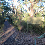
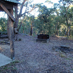


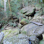
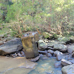
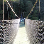
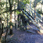
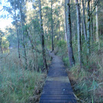
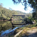


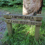
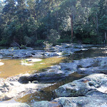
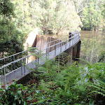

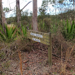


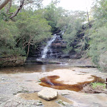
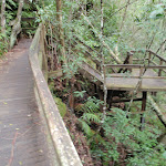

Girrakool Picnic Area
(0km) Girrakool picnic area car park → Illoura Lookout
270 m
6 mins
0m
-33m
Easy track
Continue straight: From the intersection, this walk follows the ‘Girrakool Loop’ sign down along the stone path. The path soon heads down some steps and comes to a fenced and signposted ‘Illoura Lookout’.
(0.27km) Illoura Lookout → Int of Girrakool and Camp Kariong tracks
970 m
23 mins
44m
-65m
Moderate track
Veer left: From the top of Piles Creek waterfall, this walk follows the track heading south away from the waterfall (keeping the big valley to the right). The clear track winds through the thick bush crossing a few small tributaries and though four sandstone caves. The caves provide good shelter and a great spot to rest. The track then flattens out and comes to a 3-way intersection and a ‘Girrakool’ sign.
(1.24km) Int of Girrakool and Camp Kariong tracks → Int of Girrakool and Piles Ck lookout tracks
140 m
4 mins
3m
-18m
Moderate track
(1.38km) Int of Girrakool and Piles Ck lookout tracks → Piles Ck Lookout
20 m
1 mins
0m
-8m
Moderate track
Piles Creek Lookout
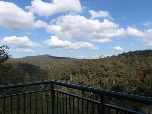
(1.38km) Int of Girrakool and Piles Ck lookout tracks → Monolith Cave
80 m
2 mins
16m
0m
Moderate track
Monolith Cave
(1.46km) Monolith Cave → Rat Gully Lookout
220 m
7 mins
13m
-29m
Moderate track
(1.68km) Rat Gully Lookout → Int of Patonga Ferry and Girrakool tracks
290 m
8 mins
14m
-33m
Moderate track
(1.97km) Int of Patonga Ferry and Girrakool tracks → Phil Houghton Bridge
220 m
9 mins
17m
-47m
Moderate track
Phil Houghton Bridge
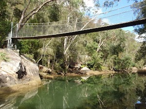
(2.19km) Phil Houghton Bridge → Mooney Mooney Creek Trackhead
2.3 km
47 mins
88m
-68m
Moderate track
Turn right: From the intersection, this walk follows the GNW arrow post[24] directly away from the face of the ‘Brisbane Waters National Park’ sign[25] along the clear track[26], keeping Mooney Mooney Creek to your left. After about 100m, this walk crosses a green timber footbridge[27], then about 200m later comes to a small clearing and intersection just before the road bridge[28]. Here the walk turns right, following the old management trail uphill through the tall forest[29] for about 200m then heading around a locked gate[30]. Just past the gate, this walk turn left and heads up the short steep bank[31] to come to a T-intersection with the old Pacific Hwy, at a large gravel car park[32] marked with ‘Mooney Mooney Creek’ Trackhead[33] (just east of the Mooney Mooney Creek bridge).
(4.52km) Mooney Mooney Creek Trackhead → Int of Karool Rd and Old Pacific Highway
320 m
7 mins
12m
-25m
Easy track
Old Pacific Highway Mooney Mooney Creek Bridge
This road became the ‘Old Pacific Highway’ upon the opening of the F3, or Sydney-Newcastle Freeway, in the 1980s. This bridge is the smaller of two crossing Mooney Mooney Creek – the other, Mooney Mooney Bridge, is part of the F3 freeway and is the highest road bridge in Australia.
(4.84km) Int of Karool Rd and Old Pacific Highway → Int under Mooney Mooney Bridge
820 m
14 mins
11m
-21m
Very easy
(5.66km) Int under Mooney Mooney Bridge → Footbridge
2 km
38 mins
58m
-54m
Moderate track
Continue straight: From the end of the dirt road[55] (that branches of Karool Rd, just north of the Mooney Mooney Bridge), this walk heads uphill along the trail and around the locked gate[56] next to the timber ‘Brisbane Water National Park’ sign[57]. The trail leads uphill for about 200m to where the trail bends left to pass over the crest of the hill (passing a faint track on your left[58]). Here the trail leads down the other side, still keeping Mooney Mooney Creek to your right[59] for another 400m to come to an intersection marked with a GNW arrow post[60], beside a large grassy clearing[61] (no camping).
Veer right: From the intersection[62] just above the clearing, this walk follows the GNW arrow post[63] down along the track, keeping the clearing and campsite[64] to the right. The track soon leads over a small flat timber bridge[65] then over the next 60m, the track heads under the high tension power lines (past the caution sign[66]) and then along a short section of timber boardwalk[67]. About 20m later, this walk veers right at a Y-intersection[68], then continues along the mostly flat track beside Mooney Mooney Creek for about 300m, to cross a small rocky tidal creek[69]. The track then continues through the tall forest[70] beside Mooney Mooney Creek for about 600m, passing a couple of she-oak stands[71] before the track then bends left and comes to an indistinct intersection[72] beside a timber and metal footbridge[73].
(7.67km) Footbridge → Ausburn Creek crossing
1.5 km
27 mins
34m
-24m
Moderate track
Continue straight: From the campsite[80], this walk follows the clear track north, keeping the wide Mooney Mooney Creek to your right. The clear, wide and mostly flat track leads alongside the creek[81] for about 1.2km to come to the southern bank of Ausburn Creek[82] (about 130m past a rock wall[83], on your left), a few metres above its confluence with Mooney Mooney Creek[84]
(9.15km) Ausburn Creek crossing → Lower Mooney Mooney Dam
2.1 km
50 mins
135m
-98m
Moderate track
Continue straight: From the bank of Mooney Mooney Creek, this walk crosses the wide rock platform[91] and creek[92] to find the track again on the other side[93]. This creek may become impassable after heavy or prolonged rain. Here the walk turns left and follows the rocky track that leads gently up alongside the creek through the pleasant forest[94]. After a little over 1km, the walk comes into view of the tailwater of the dam[95] and then past a fenced cutting[96] (on your right), the site of an old pump house[97]. About 60m past this fenced area, the walk leads up along the now widening track to find the edge of the fenced lower Mooney Mooney Dam wall[98].
(11.22km) Lower Mooney Mooney Dam → Int of the dam trail and the old Somersby Falls track
1.7 km
40 mins
143m
-25m
Moderate track
Lower Mooney Dam
(12.89km) Int of Great North Walk and Somersby Falls track → Int of Great North Walk and Somersby Falls GNW track head
700 m
16 mins
45m
-19m
Moderate track
(13.58km) Int of Great North Walk and Somersby Falls GNW track head → Somersby Falls picnic area entrance
1.6 km
29 mins
26m
-47m
Moderate track
Somersby Falls Picnic Area

(15.21km) Somersby Falls picnic area entrance → Bottom of Bottom Falls
340 m
7 mins
3m
-45m
Moderate track
Turn right: From the information board at Somersby Falls Picnic area (at the end of Somersby Road), this walk follows the ‘To the Falls’ sign down the stone, then timber stairs. At the bottom of the timber staircase the walk comes to an intersection with a short path leading to the 1st Fall Lookout.
Veer left: From the bottom of the stairs, this walk follows the stone stairs down the hill (keeping the valley to the right). The track passes through some pleasant bush, past a metal arrow post to come to a faint ‘T’ intersection with a dirt track.
Veer right: From the bottom of the stone steps, this walk follows the timber steps and track down the hill. The track soon leads to a ‘Y’ intersection with a ‘Top Fall / Bottom Fall’ sign.
Turn left: From the intersection, this walk follows the ‘Bottom Falls’ sign down the hill (keeping the main valley on the right). The track soon heads along a sandstone platform (passing a metal arrow) and down the stone steps to come to a timber platform. The walk follows the platform and heads down the staircases. At the bottom of the timber staircases, the walk turns sharply right to follows the stone steps down to the creek (On the way the track passes over a slippery unfenced rock ledge, care is needed). Just before the creek there is a ‘No Track Beyond this point’ sign. The steps then lead to the rock platform at the base of the falls. (The rock platform can be slippery and there is an unfenced cliff) At the end of this side trip, retrace your steps back to the main walk then Continue straight.
Somersby Falls (top)

(15.21km) Somersby Falls picnic area entrance → Int of Pile Rd and Old Pacific Highway
3 km
55 mins
63m
-75m
Easy track
Turn right: From the roundabout, the walk heads south along Pile Road to the end, where it meets the Old Pacific Highway.
(18.24km) Int of Pile Rd and Old Pacific Highway → Int of Girrakool and Quarry Rds
1.1 km
21 mins
14m
-41m
Moderate track
Turn left: From the intersection, the walk follows Girrakool Road down the hill for a short distance to the intersection with Quarry Rd.
(19.37km) Int of Girrakool and Gosford Quarries Rds → Girrakool picnic area car park
610 m
11 mins
8m
-25m
Easy track
Maps for the Somersby & Mooney Mooney Creek Loop walk
You can download the PDF for this walk to print a map.
These maps below cover the walk and the wider area around the walk, they are worth carrying for safety reasons.
| Gunderman | 1:25 000 Map Series | 91313S GUNDERMAN | NSW-91313S |
| Gosford | 1:25 000 Map Series | 91312S GOSFORD | NSW-91312S |
| Gosford | 1:100 000 Map Series | 9131 GOSFORD | 9131 |
Cross sectional view of the Somersby & Mooney Mooney Creek Loop bushwalking track
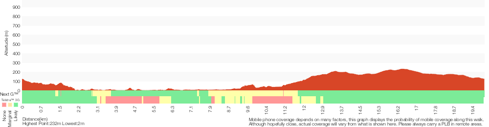
Analysis and summary of the altitude variation on the Somersby & Mooney Mooney Creek Loop
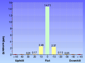
Overview of this walks grade – based on the AS 2156.1 – 2001
Under this standard, a walk is graded based on the most difficult section of the walk.
| Length | 20 km | ||
| Time | 7 hrs 30 mins | ||
| . | |||
| Grade 3/6 Moderate track |
AS 2156.1 | Gradient | Short steep hills (3/6) |
| Quality of track | Formed track, with some branches and other obstacles (3/6) | ||
| Signs | Directional signs along the way (3/6) | ||
| Experience Required | Some bushwalking experience recommended (3/6) | ||
| Weather | Storms may impact on navigation and safety (3/6) | ||
| Infrastructure | Limited facilities, not all cliffs are fenced (3/6) |
Some more details of this walks Grading
Here is a bit more details explaining grading looking at sections of the walk
Gradient
12km of this walk has gentle hills with occasional steps and another 4.7km has short steep hills. The remaining (2.8km) is flat with no steps.
Quality of track
8km of this walk follows a smooth and hardened path and another 7km follows a clear and well formed track or trail. The remaining (6km) follows a formed track, with some branches and other obstacles.
Signs
Around 11km of this walk has directional signs at most intersection, whilst the remaining 9km is clearly signposted.
Experience Required
Around 15km of this walk requires no previous bushwalking experience, whilst the remaining 5km requires some bushwalking experience.
weather
Around 18km of this walk is not usually affected by severe weather events (that would unexpectedly impact safety and navigation), whilst the remaining 1.8km is affected by storms that may impact your navigation and safety.
Infrastructure
Around 18km of this walk is close to useful facilities (such as fenced cliffs and seats), whilst the remaining 2km has limited facilities (such as not all cliffs fenced).
Similar walks
A list of walks that share part of the track with the Somersby & Mooney Mooney Creek Loop walk.
426 m Return
20 mins
Moderate track
803 m Circuit
20 mins
Moderate track
1.1 km Circuit
30 mins
Moderate track
1.4 km Circuit
45 mins
Moderate track
4.2 km Circuit
2 hrs
Moderate track
9.5 km One way
4 hrs
Hard track
10.1 km One way
4 hrs 15 mins
Hard track
12.3 km One way
5 hrs 30 mins
Hard track
16.1 km One way
6 hrs
Hard track
18.1 km One way
7 hrs 30 mins
Experienced only
20.7 km One way
8 hrs 30 mins
Hard track
24.8 km One way
10 hrs
Hard track
24.8 km One way
2 Days
Hard track
26.2 km One way
10 hrs
Hard track
26.2 km One way
2 Days
Hard track
41.5 km One way
3 Days
Hard track
Other Nearby walks
A list of walks that start near the Somersby & Mooney Mooney Creek Loop walk.
378 m Return
10 mins
Easy track
800 m Return
20 mins
Very easy
991 m One way
30 mins
Moderate track
1.7 km Circuit
45 mins
Moderate track
3 km Return
1 hr 30 mins
Hard track
2.2 km One way
1 Hr
Hard track
3 km One way
1 hr 30 mins
Hard track
2.1 km Circuit
1 hr 15 mins
Hard track
6.1 km Circuit
2 hrs 45 mins
Hard track
11.3 km One way
4 hrs 30 mins
Hard track
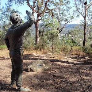
643 m Circuit
30 mins
Moderate track
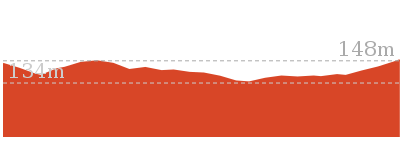
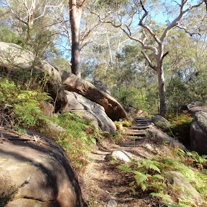
1.4 km Circuit
45 mins
Hard track
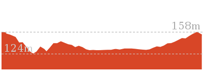
Plan your trip to and from the walk here
The Somersby & Mooney Mooney Creek Loop walk starts and ends at the Girrakool picnic area car park (gps: -33.43168, 151.2766)
Your main transport option to Girrakool picnic area car park is by;
![]() Car. Parking fees apply in the area.
Car. Parking fees apply in the area.
(get details)
Short URL = http://wild.tl/smcl
Gallery images
There are other downloads I am still working on.
You will probably need to login to access these — still all free.
* KML (google earth file)
* GPX (GPS file)
Special Maps/ brochures
* A3 topo maps
* PDF with Lands Topo map base
* PDF with arial image (and map overlay)
I wanted to get the main site live first, this extra stuff will come in time.
Happy walking
Matt 🙂
Girrakool to Woy Woy station via Mt Wondabyne

8 hrs 30 mins
870 m
Hard track
This long day-walk starts from the Girrakool picnic area and works its way south, alongside Piles creek and through the Brisbane Waters National Park. The walk climbs over Scopas Peak and passes the Kariong brook falls, before winding to the top of Mt Wondabyne and finishing at the Woy Woy train station, (passing the Woy Woy landfill site). If doing a car shuffle, you can park a car near the landfill and save the road section.
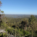

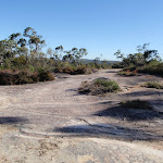
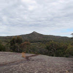
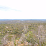
Girrakool Picnic Area
(0km) Girrakool picnic area car park → Illoura Lookout
270 m
6 mins
0m
-33m
Easy track
Continue straight: From the intersection, this walk follows the ‘Girrakool Loop’ sign down along the stone path. The path soon heads down some steps and comes to a fenced and signposted ‘Illoura Lookout’.
Illoura Lookout
(0.27km) Illoura Lookout → Piles Creek Waterfall
70 m
2 mins
0m
-10m
Moderate track
(0.34km) Piles Creek Waterfall → Int of Girrakool and Piles Ck lookout tracks
1 km
25 mins
47m
-73m
Moderate track
Continue straight: From the intersection, the walk heads south along the wide track in the opposite direction of the ‘Girrakool’ sign. Soon the track heads down a short wooden staircase to the intersection at the bottom (Piles Creek Lookout visible to the right).
(1.38km) Int of Girrakool and Piles Ck lookout tracks → Piles Ck Lookout
20 m
1 mins
0m
-8m
Moderate track
Piles Creek Lookout
(1.38km) Int of Girrakool and Piles Ck lookout tracks → Monolith Cave
80 m
2 mins
16m
0m
Moderate track
Monolith Cave
(1.46km) Monolith Cave → Rat Gully Lookout
220 m
7 mins
13m
-29m
Moderate track
(1.68km) Rat Gully Lookout → Tributary Crossing
1 km
29 mins
96m
-81m
Hard track
Turn sharp left: From the intersection, this walk follows the ‘Patonga Ferry’ sign[3] up the side of the gully, keeping the intermittent creek[4] to your left. The track leads past a ‘Patonga’ sign then winds steeply up the hill for about 130m, through a cleft in the rock[5] and past a few rock walls, and then the track mostly flattens out with some filtered distant views[6]. The track continues gently uphill for another 300m, becoming progressively flatter[7] before passing along the side of a long rock wall[8], with a tall sandstone overhang[9]. The track then crosses a small gully and leads past another overhang, where the track begins to lead downhill. The rocky track winds steeply downhill for about 130m to then cross an intermittent creek which flows over the solid sandstone platform[10].
(2.69km) Tributary Crossing → Scopas Peak
2.4 km
57 mins
189m
-33m
Hard track
(5.11km) Scopas Peak → South end of Scopas Peak Track
1.2 km
23 mins
14m
-80m
Hard track
Continue straight: From the Great North Walk intentions book[29], after leaving your comments, this walk heads south, gently downhill[30] along the clear track. After about 150m, the walk comes to a T-intersection[31] with the Gosford Rifle Range trail – At this intersection is a ‘Girrakool’ sign[32], pointing back along the track.
(6.27km) Int of GNW and Gosford Rifle Range trail → Int of GNW and Wondabyne trail
1.1 km
22 mins
40m
-27m
Moderate track
(7.4km) Int of GNW and Wondabyne Station Trail → Myron Brook crossing
1.6 km
36 mins
36m
-178m
Hard track
(8.96km) Myron Brook crossing → Kariong Brook crossing
400 m
11 mins
28m
-33m
Hard track
Kariong Brook Falls
(9.36km) Kariong Brook crossing → Int of the Great North Walk and Patonga service trail
690 m
24 mins
122m
-21m
Hard track
(10.05km) Int of the Great North Walk and Patonga service trail → Int of GNW and Thommos Loop track
1.5 km
28 mins
54m
-34m
Moderate track
(11.54km) Int of GNW and Thommos Loop trail → Int of GNW and Mullet Creek Trail
1 km
22 mins
29m
-54m
Moderate track
Turn right: From the intersection, the track follows the GNW arrow post along the management trail[80], initially keeping the power lines to your right. The trail soon bends left and leads uphill. As the trail flattens out again, it comes to a three-way intersection marked with a ‘Great North Walk’ and ‘Wondabyne Station’ sign[81], pointing back along the trail.
(12.58km) Int of GNW and Mullet Creek Trail → Int of GNW and Mt Wondabyne Peak tracks
950 m
21 mins
109m
-11m
Hard track
(13.53km) Int of Great North Walk and Mt Wondabyne Peak tracks → Mt Wondabyne Peak
210 m
5 mins
20m
-1m
Hard track
Mt Wondabyne
(13.53km) Int of Great North Walk and Mt Wondabyne Peak tracks → Mt Wondabyne Campsite
90 m
2 mins
0m
-6m
Moderate track
Mt Wondabyne Campsite
(13.62km) Mt Wondabyne Campsite → Int of Tunnel Track and Mt Wondabyne trail
760 m
16 mins
0m
-49m
Moderate track
(14.37km) Int of Tunnel Track and Mt Wondabyne trail → Int of Rocky Ponds Trail and Tunnel Track
470 m
9 mins
8m
-15m
Easy track
(14.84km) Int of Rocky Ponds Trail and Tunnel Track → Int of Hawkesbury Track and Dillons Trail
190 m
3 mins
1m
-8m
Moderate track
Turn left: From the intersection, this walk follows the GNW arrow post directly away from the face of the ‘Tunnel Trail’ sign[113][114] along the narrow track. After about 20m, this short track leads to an intersection with the signposted ‘Dillons Trail’[115].
(15.02km) Int of Great North Walk service trail and Patonga track → Woy Woy Landfill
1.8 km
34 mins
24m
-112m
Moderate track
(16.78km) Woy Woy Landfill → Woy Woy Landfill site front gates
1 km
23 mins
38m
-84m
Easy track
(17.79km) Woy Woy Landfill site front gates → Woy Woy train station
2.9 km
45 mins
6m
-21m
Easy track
Continue straight: From the intersection, this walk follows Railway Street through the residential area, past the shopping centre to the Woy Woy train station.
Maps for the Girrakool to Woy Woy station via Mt Wondabyne walk
You can download the PDF for this walk to print a map.
These maps below cover the walk and the wider area around the walk, they are worth carrying for safety reasons.
| Gunderman | 1:25 000 Map Series | 91313S GUNDERMAN | NSW-91313S |
| Gosford | 1:25 000 Map Series | 91312S GOSFORD | NSW-91312S |
| Broken Bay | 1:25 000 Map Series | 91301N BROKEN BAY | NSW-91301N |
| Gosford | 1:100 000 Map Series | 9131 GOSFORD | 9131 |
| Sydney | 1:100 000 Map Series | 9130 SYDNEY | 9130 |
Cross sectional view of the Girrakool to Woy Woy station via Mt Wondabyne bushwalking track
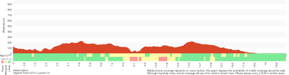
Analysis and summary of the altitude variation on the Girrakool to Woy Woy station via Mt Wondabyne
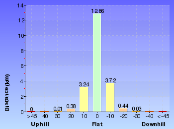
Overview of this walks grade – based on the AS 2156.1 – 2001
Under this standard, a walk is graded based on the most difficult section of the walk.
| Length | 20.7 km | ||
| Time | 8 hrs 30 mins | ||
| . | |||
| Grade 4/6 Hard track |
AS 2156.1 | Gradient | Very steep (4/6) |
| Quality of track | Rough track, where fallen trees and other obstacles are likely (4/6) | ||
| Signs | Minimal directional signs (4/6) | ||
| Experience Required | Some bushwalking experience recommended (3/6) | ||
| Weather | Storms may impact on navigation and safety (3/6) | ||
| Infrastructure | Limited facilities, not all cliffs are fenced (3/6) |
Some more details of this walks Grading
Here is a bit more details explaining grading looking at sections of the walk
Gradient
8km of this walk has gentle hills with occasional steps and another 6km is very steep. Whilst another 6km has short steep hills and the remaining 160m is flat with no steps.
Quality of track
7km of this walk follows a clear and well formed track or trail and another 6km follows a rough track, where fallen trees and other obstacles are likely. Whilst another 3.9km follows a smooth and hardened path and the remaining 3.5km follows a formed track, with some branches and other obstacles.
Signs
10km of this walk has directional signs at most intersection and another 7km is clearly signposted. The remaining (3.5km) has minimal directional signs.
Experience Required
Around 11km of this walk requires no previous bushwalking experience, whilst the remaining 9km requires some bushwalking experience.
weather
Around 19km of this walk is not usually affected by severe weather events (that would unexpectedly impact safety and navigation), whilst the remaining 1.7km is affected by storms that may impact your navigation and safety.
Infrastructure
Around 16km of this walk is close to useful facilities (such as fenced cliffs and seats), whilst the remaining 4.2km has limited facilities (such as not all cliffs fenced).
Similar walks
A list of walks that share part of the track with the Girrakool to Woy Woy station via Mt Wondabyne walk.
803 m Circuit
20 mins
Moderate track
1.1 km Circuit
30 mins
Moderate track
1.4 km Circuit
45 mins
Moderate track
4.2 km Circuit
2 hrs
Moderate track
5.8 km Return
2 hrs 30 mins
Hard track
8.1 km Return
3 hrs 30 mins
Hard track
9.5 km One way
4 hrs
Hard track
10.1 km One way
4 hrs 15 mins
Hard track
10.8 km Circuit
4 hrs 30 mins
Hard track
12.3 km One way
5 hrs 30 mins
Hard track
15.4 km One way
6 hrs
Hard track
15.5 km One way
5 hrs 45 mins
Hard track
16.1 km One way
6 hrs 30 mins
Experienced only
17 km One way
6 hrs 30 mins
Hard track
18.1 km One way
7 hrs 30 mins
Experienced only
19.5 km One way
7 hrs 30 mins
Hard track
20 km Circuit
7 hrs 30 mins
Moderate track
24 km One way
8 hrs 30 mins
Experienced only
24.8 km One way
10 hrs
Hard track
24.8 km One way
2 Days
Hard track
26.2 km One way
10 hrs
Hard track
26.2 km One way
2 Days
Hard track
28.1 km One way
2 Days
Experienced only
33.4 km One way
2 Days
Hard track
41.5 km One way
3 Days
Hard track
Other Nearby walks
A list of walks that start near the Girrakool to Woy Woy station via Mt Wondabyne walk.
378 m Return
10 mins
Easy track
16.1 km One way
6 hrs
Hard track
800 m Return
20 mins
Very easy
426 m Return
20 mins
Moderate track
991 m One way
30 mins
Moderate track
1.7 km Circuit
45 mins
Moderate track
3 km Return
1 hr 30 mins
Hard track
2.2 km One way
1 Hr
Hard track
3 km One way
1 hr 30 mins
Hard track
2.1 km Circuit
1 hr 15 mins
Hard track
6.1 km Circuit
2 hrs 45 mins
Hard track
11.3 km One way
4 hrs 30 mins
Hard track
Plan your trip to and from the walk here
The Girrakool to Woy Woy station via Mt Wondabyne walk starts at the Girrakool picnic area car park (gps: -33.43168, 151.2766)
Your main transport option to Girrakool picnic area car park is by;
![]() Car. A park entry fee is required for driving into the park.
Car. A park entry fee is required for driving into the park.
(get details)
The Girrakool to Woy Woy station via Mt Wondabyne ends at the Woy Woy train station (gps: -33.485814, 151.32361)
Your transport options to Woy Woy train station are by;
![]() Train. (get details)
Train. (get details)
![]() Bus. (get details)
Bus. (get details)
![]() Car. There is free parking available.
Car. There is free parking available.
(get details)
Short URL = http://wild.tl/gtwwsvmw
Gallery images
There are other downloads I am still working on.
You will probably need to login to access these — still all free.
* KML (google earth file)
* GPX (GPS file)
Special Maps/ brochures
* A3 topo maps
* PDF with Lands Topo map base
* PDF with arial image (and map overlay)
I wanted to get the main site live first, this extra stuff will come in time.
Happy walking
Matt 🙂
Wondabyne to Woy Woy station via Pindar Caves
8 hrs 30 mins
949 m
Experienced only
This full day walk is for the fit and keen bushwalker, exploring some of the Brisbane Waters National Park’s great destinations like the Pindar caves, the Kariong Brook falls and Mt Wondabyne. The walk offers a few optional side trips to key locations including Pindar falls and the Mt Wondabyne Peak tracks. As the track ends at Woy Woy train station, there are regular trains for the trip home.* This walk passes through very remote areas and sections have no visible track. At least one person in your group should have training and experience in off track walking and navigation. Even with these notes and a GPS these extra skills and equipment are required.
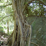
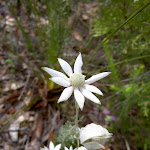
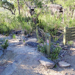
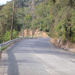
Wondabyne
(0km) Wondabyne Station → Eastern end of the Pindar Cave Track
1.5 km
32 mins
172m
-18m
Hard track
Continue straight: From the clearing[14], this walk follows the wide management trail uphill past the ‘Brisbane Water National Park’ sign[15]. The trail leads up quite steeply[16] for about 250m, where the trail bends right then leads gently uphill[17] for about 600m. Here the trail leads up a short but quite steep hill[18], to then bend left and, about 150m later, come to an intersection with the Pindar Cave track (that leads over a rock platform[19], on your left), marked with a GNW arrow post[20] (on your right).
(1.47km) Int. Rifle Range Service Track and Pindar Cave Track → Mt Pindar Lookout
3.5 km
1 hr 12 mins
129m
-129m
Hard track
Mt Pindar lookout
(4.97km) Mt Pindar Lookout → Pool
480 m
9 mins
2m
-25m
Experienced only
Pindar Pool
(5.45km) Pool → Pindar Cave
320 m
6 mins
12m
-6m
Experienced only
Pindar Cave
(5.77km) Pindar Cave → Waterfall
570 m
12 mins
10m
-57m
Very experienced only
Pindar Waterfall
(5.77km) Pindar Cave → Int. Rifle Range Service Track and Pindar Cave Track
4.3 km
1 hr 27 mins
160m
-143m
Experienced only
Turn right: From the pool, the walk follows the bush track east, out of the clearing. The track passes through an area of thick vegetation as is slowly climbs up the spur, before the vegetation gives way to a rocky area. The track winds further up the hill and along the ridge edge to the lookout.
Turn left: From the lookout, the walk heads south-east along the rocky surface, to the dense tree line and follows the sandy track. This track soon bends to the north, going up the spur and across the plateau of Mt Pindar. From here the track undulates for some time and then widens to a management trail. The walk follows the management trail for a short distance, passing a large rocky outcrop to come to a ‘T’ intersection with a wide management trail.
(10.06km) Eastern end of the Pindar Cave Track → Int of GNW and Wondabyne Station tracks
630 m
11 mins
19m
-5m
Moderate track
(10.69km) Int of GNW and Wondabyne Station Trail → Kariong Brook crossing
2 km
47 mins
64m
-211m
Hard track
Continue straight: From the western side of Myron Brook, this walk crosses the creek on the sandstone rock platform[31] to follow the track up a few stone steps and up the short steep hill[32]. The track then flattens out as it leads around the side of the hill for about 200m to pass alongside a long rock wall[33] (on your left). Now leading downhill, the track continues for another 100m then heads down a short steep section[34] into the dense moist gully, coming to a faint intersection in front of Kariong Brook Falls[35] (on your left) (just before crossing the creek, which is often underground).
Kariong Brook Falls
(12.66km) Kariong Brook crossing → Int of the Great North Walk and Patonga service trail
690 m
24 mins
122m
-21m
Hard track
(13.35km) Int of the Great North Walk and Patonga service trail → Int of GNW and Thommos Loop track
1.5 km
28 mins
54m
-34m
Moderate track
(14.83km) Int of GNW and Thommos Loop trail → Int of GNW and Mullet Creek Trail (east)
830 m
18 mins
15m
-50m
Moderate track
(15.66km) Int of GNW and Mullet Creek Trail (east) → Int of GNW and Mt Wondabyne Peak tracks
1.2 km
25 mins
123m
-15m
Hard track
Turn left: From the intersection, this walk follows the ‘Mt Wondabyne’ sign[65] south up the trail. The trail soon begins to narrow[66] and after almost 200m, the track steps up to cross a rock platform[67], following a few GNW arrow posts to find a GNW ‘Walker Register’ tube[68]. After writing a comment, the walk continues uphill[69] along the track for about 700m, as the track become progressively flatter[70], passing beside the Mt Wondabyne Peak (up to your left). Then about 50m after leaving the trees and entering a section of low heath, this track then comes to a three-way intersection[71] (the Mt Wondabyne peak track, on the left[72]), marked with a GNW arrow post.
(16.82km) Int of Great North Walk and Mt Wondabyne Peak tracks → Mt Wondabyne Peak
210 m
5 mins
20m
-1m
Hard track
Mt Wondabyne
(16.82km) Int of Great North Walk and Mt Wondabyne Peak tracks → Mt Wondabyne Campsite
90 m
2 mins
0m
-6m
Moderate track
Mt Wondabyne Campsite
(16.91km) Mt Wondabyne Campsite → Int of Tunnel Track and Mt Wondabyne trail
760 m
16 mins
0m
-49m
Moderate track
(17.67km) Int of Tunnel Track and Mt Wondabyne trail → Int of Rocky Ponds Trail and Tunnel Track
470 m
9 mins
8m
-15m
Easy track
(18.13km) Int of Rocky Ponds Trail and Tunnel Track → Woy Woy Landfill
1.9 km
37 mins
25m
-120m
Moderate track
Turn left: From the intersection, this walk follows the GNW arrow post directly away from the face of the ‘Tunnel Trail’ sign[96][97] along the narrow track. After about 20m, this short track leads to an intersection with the signposted ‘Dillons Trail’[98].
Turn left: With the Patonga-bound bush track on the right, this walk follows the management trail east, down the long, gentle hill. The trail gradually steepens as it winds down to the Woy Woy Landfill site. The walk then follows the landfill fence past a building and steps through a gap in the fence. The walk then heads along the gravel driveway to the landfill road.
(20.08km) Woy Woy Landfill → Woy Woy Landfill site front gates
1 km
23 mins
38m
-84m
Easy track
(21.09km) Woy Woy Landfill site front gates → Woy Woy train station
2.9 km
45 mins
6m
-21m
Easy track
Continue straight: From the intersection, this walk follows Railway Street through the residential area, past the shopping centre to the Woy Woy train station.
Maps for the Wondabyne to Woy Woy station via Pindar Caves walk
You can download the PDF for this walk to print a map.
These maps below cover the walk and the wider area around the walk, they are worth carrying for safety reasons.
| Gunderman | 1:25 000 Map Series | 91313S GUNDERMAN | NSW-91313S |
| Gosford | 1:25 000 Map Series | 91312S GOSFORD | NSW-91312S |
| Broken Bay | 1:25 000 Map Series | 91301N BROKEN BAY | NSW-91301N |
| Gosford | 1:100 000 Map Series | 9131 GOSFORD | 9131 |
| Sydney | 1:100 000 Map Series | 9130 SYDNEY | 9130 |
Cross sectional view of the Wondabyne to Woy Woy station via Pindar Caves bushwalking track
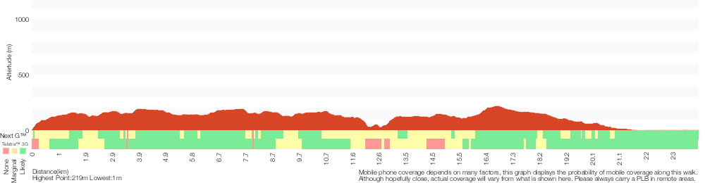
Analysis and summary of the altitude variation on the Wondabyne to Woy Woy station via Pindar Caves
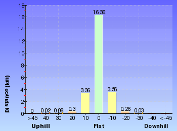
Overview of this walks grade – based on the AS 2156.1 – 2001
Under this standard, a walk is graded based on the most difficult section of the walk.
| Length | 24 km | ||
| Time | 8 hrs 30 mins | ||
| . | |||
| Grade 5/6 Experienced only |
AS 2156.1 | Gradient | Very steep (4/6) |
| Quality of track | Rough unclear track (5/6) | ||
| Signs | No directional signs (5/6) | ||
| Experience Required | Moderate level of bushwalking experience recommended (4/6) | ||
| Weather | Storms may impact on navigation and safety (3/6) | ||
| Infrastructure | Limited facilities (such as cliffs not fenced, significant creeks not bridged) (4/6) |
Some more details of this walks Grading
Here is a bit more details explaining grading looking at sections of the walk
Gradient
12km of this walk is very steep and another 6km has gentle hills with occasional steps. Whilst another 6km has short steep hills and the remaining 25m is flat with no steps.
Quality of track
11km of this walk follows a rough track, where fallen trees and other obstacles are likely and another 7km follows a clear and well formed track or trail. Whilst another 3.9km follows a smooth and hardened path and a 1.6km section follows a rough unclear track. The remaining 1.4km follows a formed track, with some branches and other obstacles.
Signs
8km of this walk has minimal directional signs and another 8km has directional signs at most intersection. Whilst another 6km is clearly signposted and the remaining 1.6km Has no directional signs.
Experience Required
12km of this walk requires some bushwalking experience and another 10km requires no previous bushwalking experience. The remaining (1.6km) requires a leader a with moderate level of bushwalking experience.
weather
Around 23km of this walk is not usually affected by severe weather events (that would unexpectedly impact safety and navigation), whilst the remaining 690m is affected by storms that may impact your navigation and safety.
Infrastructure
13km of this walk is close to useful facilities (such as fenced cliffs and seats) and another 9km has limited facilities (such as cliffs not fenced, significant creeks not bridged). The remaining (2.6km) has limited facilities (such as not all cliffs fenced).
Similar walks
A list of walks that share part of the track with the Wondabyne to Woy Woy station via Pindar Caves walk.
5.8 km Return
2 hrs 30 mins
Hard track
8.1 km Return
3 hrs 30 mins
Hard track
9.5 km One way
4 hrs
Hard track
10.1 km One way
4 hrs 15 mins
Hard track
10.8 km Circuit
4 hrs 30 mins
Hard track
11.5 km Return
6 hrs
Experienced only
12.3 km One way
5 hrs 30 mins
Hard track
15.4 km One way
6 hrs
Hard track
15.5 km One way
5 hrs 45 mins
Hard track
16.1 km One way
6 hrs 30 mins
Experienced only
17 km One way
6 hrs 30 mins
Hard track
18.1 km One way
7 hrs 30 mins
Experienced only
19.5 km One way
7 hrs 30 mins
Hard track
20.7 km One way
8 hrs 30 mins
Hard track
24.8 km One way
10 hrs
Hard track
24.8 km One way
2 Days
Hard track
26.2 km One way
10 hrs
Hard track
26.2 km One way
2 Days
Hard track
28.1 km One way
2 Days
Experienced only
33.4 km One way
2 Days
Hard track
41.5 km One way
3 Days
Hard track
Other Nearby walks
A list of walks that start near the Wondabyne to Woy Woy station via Pindar Caves walk.
800 m Return
20 mins
Very easy
16.1 km One way
6 hrs
Hard track
4.3 km One way
1 hr 45 mins
Moderate track
4.3 km Return
2 hrs
Moderate track
931 m Circuit
30 mins
Moderate track
1.4 km Return
30 mins
Very easy
1.4 km Return
30 mins
Easy track
18.1 km Return
8 hrs
Hard track
803 m Circuit
20 mins
Moderate track
378 m Return
10 mins
Easy track
1.4 km Circuit
45 mins
Moderate track
4.2 km Circuit
2 hrs
Moderate track
Plan your trip to and from the walk here
The Wondabyne to Woy Woy station via Pindar Caves walk starts at the Wondabyne Station (gps: -33.492083, 151.25696)
Your transport options to Wondabyne Station are by;
![]() Train. (get details)
Train. (get details)
![]() Train. (get details)
Train. (get details)
Important Note: There is no car transport option to the start of this walk.
The Wondabyne to Woy Woy station via Pindar Caves ends at the Woy Woy train station (gps: -33.485814, 151.32361)
Your transport options to Woy Woy train station are by;
![]() Bus. (get details)
Bus. (get details)
![]() Car. There is free parking available.
Car. There is free parking available.
(get details)
Short URL = http://wild.tl/wtwwsvpc
Gallery images
There are other downloads I am still working on.
You will probably need to login to access these — still all free.
* KML (google earth file)
* GPX (GPS file)
Special Maps/ brochures
* A3 topo maps
* PDF with Lands Topo map base
* PDF with arial image (and map overlay)
I wanted to get the main site live first, this extra stuff will come in time.
Happy walking
Matt 🙂
Girrakool to Patonga
And Walk
Girrakool to Patonga

10 hrs
1083 m
Hard track
This walk explores the main ridge of Brisbane Water National Park. Starting at Girrakool picnic area in the north, this track heads over Scopas Peak, with some excellent views over Mooney Mooney creek, and then over Mt Wondabyne, further south. As the track approaches the southern edge of Brisbane Waters national park there are more views, across to Lion island and Barrenjoey head. There are bus and ferry services from Patonga.


Girrakool Picnic Area
(0km) Girrakool picnic area car park → Int of Picnic Area and Girrakool Loop tracks
230 m
5 mins
0m
-27m
Easy track
(0.23km) Int of Picnic Area and Girrakool Loop tracks → Broula Lookout
30 m
1 mins
0m
-2m
Easy track
Broula Lookout
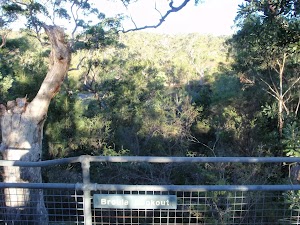
(0.23km) Int of Picnic Area and Girrakool Loop tracks → Illoura Lookout
40 m
1 mins
0m
-6m
Easy track
Illoura Lookout
(0.27km) Illoura Lookout → Int of Girrakool and Piles Ck lookout tracks
1.1 km
27 mins
47m
-83m
Moderate track
Veer left: From the top of Piles Creek waterfall, this walk follows the track heading south away from the waterfall (keeping the big valley to the right). The clear track winds through the thick bush crossing a few small tributaries and though four sandstone caves. The caves provide good shelter and a great spot to rest. The track then flattens out and comes to a 3-way intersection and a ‘Girrakool’ sign.
Continue straight: From the intersection, the walk heads south along the wide track in the opposite direction of the ‘Girrakool’ sign. Soon the track heads down a short wooden staircase to the intersection at the bottom (Piles Creek Lookout visible to the right).
(1.38km) Int of Girrakool and Piles Ck lookout tracks → Piles Ck Lookout
20 m
1 mins
0m
-8m
Moderate track
Piles Creek Lookout
(1.38km) Int of Girrakool and Piles Ck lookout tracks → Monolith Cave
80 m
2 mins
16m
0m
Moderate track
Monolith Cave
(1.46km) Monolith Cave → Rat Gully Lookout
220 m
7 mins
13m
-29m
Moderate track
(1.68km) Rat Gully Lookout → Scopas Peak
3.4 km
1 hr 26 mins
285m
-114m
Hard track
Turn sharp left: From the intersection, this walk follows the ‘Patonga Ferry’ sign[4] up the side of the gully, keeping the intermittent creek[5] to your left. The track leads past a ‘Patonga’ sign then winds steeply up the hill for about 130m, through a cleft in the rock[6] and past a few rock walls, and then the track mostly flattens out with some filtered distant views[7]. The track continues gently uphill for another 300m, becoming progressively flatter[8] before passing along the side of a long rock wall[9], with a tall sandstone overhang[10]. The track then crosses a small gully and leads past another overhang, where the track begins to lead downhill. The rocky track winds steeply downhill for about 130m to then cross an intermittent creek which flows over the solid sandstone platform[11].
Continue straight: From the west side of the creek, this walk climbs uphill following the rocky track[12]. The track climb for about 600m, fairly steeply for a while then becoming progressively less steep[13]. The track passes a couple of rocky outcrops[14] to then come to a large flat rock platform, with distant views[15]. The rocky track then leads off this rock platform and continues up the ridge[16] for just shy of 300m to come to the edge of a much larger rock platform[17] with more views. A series of GNW arrow posts lead across this rock platform, generally leading towards Scopas Peak[18] for about 400m where the arrows lead off the rock platform and back onto a heathy track[19]. Keeping Scopas Peak up to the left, this track leads around the side of the hill for about 150m to pass a view across the valley to Mooney Mooney Bridge[20]. Over the next 800m, the track leads up across a few more rock platforms[21] then climbs fairly steeply up to a view point, just to the west of Scopas Peak[22].
(5.11km) Scopas Peak → Int of GNW and Wondabyne trail
2.3 km
45 mins
54m
-107m
Hard track
Continue straight: From the Great North Walk intentions book[30], after leaving your comments, this walk heads south, gently downhill[31] along the clear track. After about 150m, the walk comes to a T-intersection[32] with the Gosford Rifle Range trail – At this intersection is a ‘Girrakool’ sign[33], pointing back along the track.
Turn right: From the intersection, this walk follows the GNW arrow post[34] downhill along the management trail[35] (directly away from the ‘No Entry Past This Point’ sign[36]). The trail undulates moderately steeply in a few places) along the ridge line for about 900m, to then walk over a large rock platform[37]. From the top of this platform, there are some distant views over Mooney Mooney Creek[38]. On the large rock platform, this walk tends left to follow the scrape marks on the rock and soon find the wide trail again[39]. The trail leads downhill for about 50m, coming to a signposted intersection with a track on your left[40] and a ‘Girrakool’ sign[41] pointing back up the trail.
(7.4km) Int of GNW and Wondabyne Station Trail → Kariong Brook crossing
2 km
47 mins
64m
-211m
Hard track
Continue straight: From the western side of Myron Brook, this walk crosses the creek on the sandstone rock platform[49] to follow the track up a few stone steps and up the short steep hill[50]. The track then flattens out as it leads around the side of the hill for about 200m to pass alongside a long rock wall[51] (on your left). Now leading downhill, the track continues for another 100m then heads down a short steep section[52] into the dense moist gully, coming to a faint intersection in front of Kariong Brook Falls[53] (on your left) (just before crossing the creek, which is often underground).
(9.36km) Kariong Brook crossing → Int of GNW and Thommos Loop track
2.2 km
52 mins
176m
-55m
Hard track
Veer right: From the intersection, this walk follows the GNW arrow post and ‘Patonga’ sign[66] downhill along the management trail[67]. The trail then winds along the side of the hill for about 1.3km (passing a pleasant grove of large Sydney Redgums[68]) to then step up onto a particularly large rock platform[69]. After crossing this rock platform, the trail continues for another 120m to come to a Y-intersection[70] (at another rock platform) where a ‘Girrakool’ sign[71] points back along the track.
(11.54km) Int of GNW and Thommos Loop trail → Int of GNW and Mt Wondabyne Peak tracks
2 km
43 mins
138m
-65m
Hard track
Turn right: From the intersection, the track follows the GNW arrow post along the management trail[81], initially keeping the power lines to your right. The trail soon bends left and leads uphill. As the trail flattens out again, it comes to a three-way intersection marked with a ‘Great North Walk’ and ‘Wondabyne Station’ sign[82], pointing back along the trail.
Turn left: From the intersection, this walk follows the ‘Mt Wondabyne’ sign[83] south up the trail. The trail soon begins to narrow[84] and after almost 200m, the track steps up to cross a rock platform[85], following a few GNW arrow posts to find a GNW ‘Walker Register’ tube[86]. After writing a comment, the walk continues uphill[87] along the track for about 700m, as the track become progressively flatter[88], passing beside the Mt Wondabyne Peak (up to your left). Then about 50m after leaving the trees and entering a section of low heath, this track then comes to a three-way intersection[89] (the Mt Wondabyne peak track, on the left[90]), marked with a GNW arrow post.
(13.53km) Int of Great North Walk and Mt Wondabyne Peak tracks → Mt Wondabyne Peak
210 m
5 mins
20m
-1m
Hard track
Mt Wondabyne
(13.53km) Int of Great North Walk and Mt Wondabyne Peak tracks → Mt Wondabyne Campsite
90 m
2 mins
0m
-6m
Moderate track
Mt Wondabyne Campsite
(13.62km) Mt Wondabyne Campsite → Int of Tunnel Track and Mt Wondabyne trail
760 m
16 mins
0m
-49m
Moderate track
(14.37km) Int of Tunnel Track and Mt Wondabyne trail → Woy Woy landfill view
2.5 km
51 mins
83m
-98m
Hard track
Continue straight: From the intersection, this walk follows the ‘Patonga’ sign[110] south, downhill along the wide trail. After just over 100m, the trail passes through a metal gate[111] and fence then continues for another 50m to come to an intersection with a narrow track[112] (on your left), marked with a GNW arrow post and ‘Tunnel Trail’[113] (on your right).
Turn left: From the intersection, this walk follows the GNW arrow post directly away from the face of the ‘Tunnel Trail’ sign[114][115] along the narrow track. After about 20m, this short track leads to an intersection with the signposted ‘Dillons Trail’[116].
Continue straight: From the intersection, this walk follows the GNW arrow post and ‘Patonga’ sign[117] south-west up along the narrow track[118]. The track leads fairly gently uphill for about 300m, then mostly flattens out along the side of a rock platform[119] for another 500m to come to a high point[120]. The track now undulates, following a series of many GNW arrow posts[121] generally down along the rocky ridge line, over many rock platforms[122] for almost 1km (enjoying the distant views[123][124] over Woy Woy Bay and the Brisbane Water, to your left). The walk then steps down off the rock platform[125] via a few carved steps[126] onto a sandy track. This track then leads gently down for about 130m, coming to an unfenced, clear view over Woy Woy landfill[127] (where the track then bends right[128]).
(16.85km) Woy Woy landfill view → Rock Platform
960 m
25 mins
39m
-77m
Hard track
Turn right: From the intersection, this walk follows the GNW arrow post uphill along the wide trail. The trail leads uphill for about 200m to then lead quite steeply downhill[139] for another 200m. Here the trail winds through a ferny valley[140] with a scattering of cabbage palms[141] (Livistona australis) then uphill for about 80m, where the trail bends right and leads down a short distance to find a noteable rock platform[142] (with an ephemeral creek) and filtered view down the valley (to your right)[143].
(17.82km) Rock Platform → Int of Hawkesbury track and Sani Depot Trail
1.3 km
25 mins
56m
-21m
Moderate track
Continue straight: From the intersection, this walk follows the wide management trail (the Hawkesbury Track) gently uphill, initially keeping the wide valley to your right. The trail leads through the open heath for about 170m to enter a more wooded forest and cross a culverted creek[147] (with sandstone blocks[148]). Here the trail begins to climb, becoming progressively steeper for about 600m before entering a tall Sydney Redgum forest and flattening out a clear three-way intersection, marked with a ‘Sani Depot Trail’ sign[149] (on your left).
(19.15km) Int of Hawkesbury track and Sani Depot Trail → Int of Hawkesbury track and Patonga Dr trail
1.1 km
21 mins
39m
-25m
Moderate track
(20.26km) Rock platform intersection → Int of Rest Area and Girrakool tracks
750 m
12 mins
12m
-5m
Moderate track
Turn right: From the intersection, this walk follows the ‘Patonga’ sign[161] south gently up along the sandy management trail. The trail leads among the heath and large scribbly gums[162] for about 270m to come to a T-intersection[163], marked with a GNW arrow post[164] (where the main trail bends left and the old Patonga Creek trail is on the right).
Turn left : From the intersection, this walk follows the GNW arrow post east, gently up along the wide management trail. After about 100m, the trail bends right[165], then continues mostly flat for nearly 200m, coming to a clear three-way intersection[166] where a ‘Girrakool’ sign[167] points back up along the trail.
(21.01km) Int of Rest Area and Girrakool tracks → Warrah Car Park
1.6 km
29 mins
22m
-25m
Moderate track
Continue straight: From the intersection and locked gate[172], this walk crosses the sealed Patonga Drive[173] to find a GNW arrow post and track on the other side. This walk now follows the GNW arrow post along the track, as it bends right to lead parallel to Patonga Drive (keeping the road about 20m to your right) for about 150m before passing some distant ocean views[174] (on your left). Here the track continues for another 100m to pass a drainage ditch[175] and come to a T-intersection[176] with the dirt Warrah Trig Station Rd.
Veer left: From the intersection near Patonga Drive, this walk follows the dirt road away from Patonga Drive. After a little while the road heads down a gentle hill then comes to an intersection with a management trail and locked gate (on the right).
Continue straight: From the intersection, this walk follows the dirt road south east towards the hill and fence. Soon the road passes a trail (on the left) and then heads through a dirt over flow car park, to come to a smaller sealed car park at the end of the road.
(22.66km) Warrah car park → Warrah Trig Station
30 m
1 mins
0m
0m
Easy track
Warrah Trig Station
(22.69km) Warrah Trig Station → Warrah Lookout intersection
310 m
7 mins
0m
-39m
Easy track
(23km) Warrah Lookout intersection → Warrah Lookout
70 m
2 mins
0m
-12m
Easy track
Warrah Lookout
(23km) Warrah Lookout intersection → Broken Bay View
700 m
15 mins
26m
-26m
Moderate track
Veer left: From the intersection, this walk follows the Great North Walk arrow and ‘Patonga’ sign[183] along the narrow track. The track winds gently through the bush, with the occasional water glimpse to the left. After a short time, the track leads to a few large Sydney Red Gums and a large unfenced rock platform on the left (just before a few Great North Walk arrow markers) – this is the Broken Bay view.
Broken Bay View
(23.7km) Broken Bay View → Patonga Wharf car park
1.1 km
31 mins
13m
-136m
Moderate track
Continue straight: From the eastern end of the beach, this walk follows the power lines across the sand, keeping the water to the left. The walk soon heads around the gate, across the car park and comes to the Warrah Reserve boat ramp.
Continue straight: From the boat ramp, this walk follows the road[186], keeping the water to the left for 220m to then turn left, following a GNW arrow post[187], down along Patonga Drive. The walk then soon leads past a ‘The Great North Walk’ sign[188] opposite the toilet block[189] and continues down past ‘Eve Williams Memorial Oval’[190][191][192] for 70m to a car park at Patonga Wharf[193], opposite some shops[194]. (Alternatively it is possible to walk along the sandy beach[195] from the Boat ramp to the wharf.)
Maps for the Girrakool to Patonga walk
You can download the PDF for this walk to print a map.
These maps below cover the walk and the wider area around the walk, they are worth carrying for safety reasons.
| Gunderman | 1:25 000 Map Series | 91313S GUNDERMAN | NSW-91313S |
| Gosford | 1:25 000 Map Series | 91312S GOSFORD | NSW-91312S |
| Broken Bay | 1:25 000 Map Series | 91301N BROKEN BAY | NSW-91301N |
| Ku-ring-gai Chase National Park Tourist Map | 1:40 000 Map Series | CMA Ku-ring-gai Chase National Park Tourist Map | CMA Ku-ring-gai Chase National Park Tourist Map |
| Gosford | 1:100 000 Map Series | 9131 GOSFORD | 9131 |
| Sydney | 1:100 000 Map Series | 9130 SYDNEY | 9130 |
Cross sectional view of the Girrakool to Patonga bushwalking track
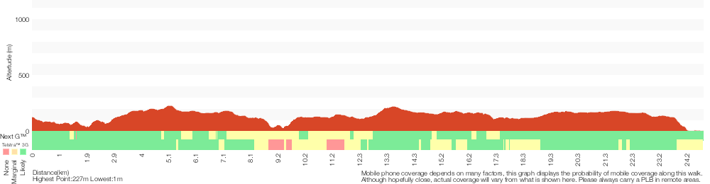
Analysis and summary of the altitude variation on the Girrakool to Patonga
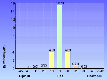
Overview of this walks grade – based on the AS 2156.1 – 2001
Under this standard, a walk is graded based on the most difficult section of the walk.
| Length | 24.8 km | ||
| Time | 10 hrs | ||
| . | |||
| Grade 4/6 Hard track |
AS 2156.1 | Gradient | Very steep (4/6) |
| Quality of track | Rough track, where fallen trees and other obstacles are likely (4/6) | ||
| Signs | Minimal directional signs (4/6) | ||
| Experience Required | Some bushwalking experience recommended (3/6) | ||
| Weather | Storms may impact on navigation and safety (3/6) | ||
| Infrastructure | Limited facilities (such as cliffs not fenced, significant creeks not bridged) (4/6) |
Some more details of this walks Grading
Here is a bit more details explaining grading looking at sections of the walk
Gradient
9km of this walk has gentle hills with occasional steps and another 8km has short steep hills. Whilst another 7km is very steep and the remaining 1.4km is flat with no steps.
Quality of track
13km of this walk follows a clear and well formed track or trail and another 8km follows a rough track, where fallen trees and other obstacles are likely. The remaining (3.8km) follows a formed track, with some branches and other obstacles.
Signs
16km of this walk has directional signs at most intersection and another 5km is clearly signposted. The remaining (3.5km) has minimal directional signs.
Experience Required
Around 13km of this walk requires no previous bushwalking experience, whilst the remaining 12km requires some bushwalking experience.
weather
Around 23km of this walk is not usually affected by severe weather events (that would unexpectedly impact safety and navigation), whilst the remaining 1.7km is affected by storms that may impact your navigation and safety.
Infrastructure
16km of this walk is close to useful facilities (such as fenced cliffs and seats) and another 9km has limited facilities (such as not all cliffs fenced). The remaining (440m) has limited facilities (such as cliffs not fenced, significant creeks not bridged).
Similar walks
A list of walks that share part of the track with the Girrakool to Patonga walk.
756 m Return
20 mins
Easy track
803 m Circuit
20 mins
Moderate track
1.1 km Circuit
30 mins
Moderate track
1.4 km Circuit
45 mins
Moderate track
2.2 km One way
1 Hr
Moderate track
2.8 km One way
1 hr 15 mins
Moderate track
4.2 km Circuit
2 hrs
Moderate track
4.3 km Return
2 hrs
Moderate track
4.3 km One way
1 hr 45 mins
Moderate track
5.1 km Return
2 hrs
Moderate track
5.8 km Return
2 hrs 30 mins
Hard track
8.1 km Return
3 hrs 30 mins
Hard track
9.5 km One way
4 hrs
Hard track
10.1 km One way
4 hrs 15 mins
Hard track
10.8 km Circuit
4 hrs 30 mins
Hard track
12.3 km One way
5 hrs 30 mins
Hard track
15.4 km One way
6 hrs
Hard track
15.5 km One way
5 hrs 45 mins
Hard track
16.1 km One way
6 hrs 30 mins
Experienced only
17 km One way
6 hrs 30 mins
Hard track
18.1 km One way
7 hrs 30 mins
Experienced only
19.5 km One way
7 hrs 30 mins
Hard track
20 km Circuit
7 hrs 30 mins
Moderate track
20.7 km One way
8 hrs 30 mins
Hard track
24 km One way
8 hrs 30 mins
Experienced only
24.8 km One way
2 Days
Hard track
26.2 km One way
10 hrs
Hard track
26.2 km One way
2 Days
Hard track
28.1 km One way
2 Days
Experienced only
33.4 km One way
2 Days
Hard track
41.5 km One way
3 Days
Hard track
Other Nearby walks
A list of walks that start near the Girrakool to Patonga walk.
378 m Return
10 mins
Easy track
16.1 km One way
6 hrs
Hard track
800 m Return
20 mins
Very easy
426 m Return
20 mins
Moderate track
991 m One way
30 mins
Moderate track
1.7 km Circuit
45 mins
Moderate track
3 km Return
1 hr 30 mins
Hard track
2.2 km One way
1 Hr
Hard track
3 km One way
1 hr 30 mins
Hard track
2.1 km Circuit
1 hr 15 mins
Hard track
6.1 km Circuit
2 hrs 45 mins
Hard track
11.3 km One way
4 hrs 30 mins
Hard track
Plan your trip to and from the walk here
The Girrakool to Patonga walk starts at the Girrakool picnic area car park (gps: -33.43168, 151.2766)
Your main transport option to Girrakool picnic area car park is by;
![]() Car. A park entry fee is required for driving into the park.
Car. A park entry fee is required for driving into the park.
(get details)
The Girrakool to Patonga ends at the Patonga Wharf car park (gps: -33.55043, 151.27456)
Your transport options to Patonga Wharf car park are by;
![]() Ferry. There is no regular ferry service between Patonga and Brooklyn any more. You can easily grab a water taxi (about +). If you are part of a large group they can also organise a larger boat carrying 35 passengers (about pp). Phone 0410 554 777 to book. Enjoy the boat ride. (get details)
Ferry. There is no regular ferry service between Patonga and Brooklyn any more. You can easily grab a water taxi (about +). If you are part of a large group they can also organise a larger boat carrying 35 passengers (about pp). Phone 0410 554 777 to book. Enjoy the boat ride. (get details)
![]() Ferry. Ferry service operates between Palm Beach and Bobbin head daily. Stopping at Patoonga Beach (and Cottage Point on request).
Ferry. Ferry service operates between Palm Beach and Bobbin head daily. Stopping at Patoonga Beach (and Cottage Point on request).
Mon – Fri 11:30am departs Patoonga for Bobbin head (then to Palm Beach)
Weekends and school holidays 9:30am, 3pm, 4:15pm from Patoonga for Palm Beach.
Phone to confirm times on the day 0414466635
(get details)
![]() Bus. A bus service runs along Patonga Drive down to Patonga. The service only runs a few times a day. Please check timetable for more info or Phone Busway on (02) 4368 2277 (route 50) (get details)
Bus. A bus service runs along Patonga Drive down to Patonga. The service only runs a few times a day. Please check timetable for more info or Phone Busway on (02) 4368 2277 (route 50) (get details)
![]() Car. There is free parking available.
Car. There is free parking available.
(get details)
Short URL = http://wild.tl/gtp
Gallery images
There are other downloads I am still working on.
You will probably need to login to access these — still all free.
* KML (google earth file)
* GPX (GPS file)
Special Maps/ brochures
* A3 topo maps
* PDF with Lands Topo map base
* PDF with arial image (and map overlay)
I wanted to get the main site live first, this extra stuff will come in time.
Happy walking
Matt 🙂
Comments