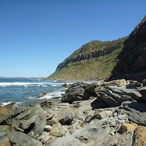
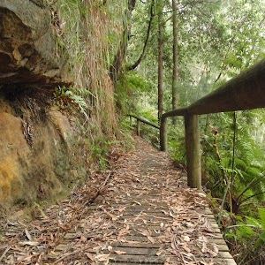
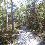
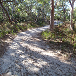
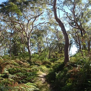
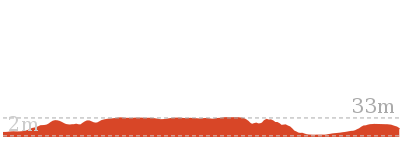
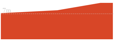
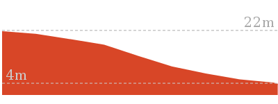
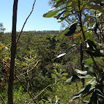
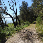
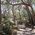
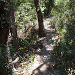
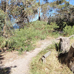
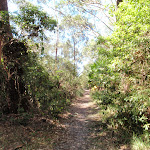
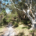
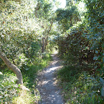
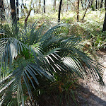
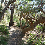
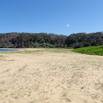
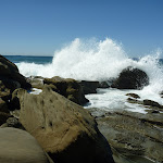
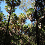
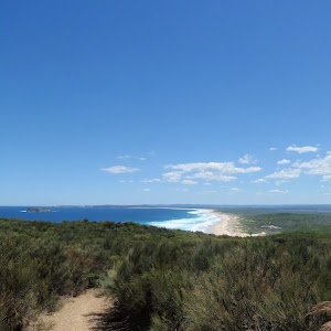
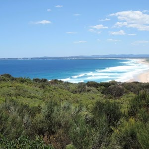
A great walk along the beach and rocky shoreline near Bateau Bay. The unnamed, rocky beach below Crackneck Lookout is a beautiful spot and there are plenty of interesting shapes and textures in the rocks and rockshelf along the way. There is a bit of rockhopping, but much less than when approaching ‘Crackneck’ beach from the south. Parts of the walk are very exposed to the ocean and should not be attempted at high tides or during high seas. * This walk passes through very remote areas and sections have no visible track. At least one person in your group should have training and experience in off track walking and navigation. Even with these notes and a GPS these extra skills and equipment are required.
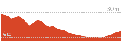
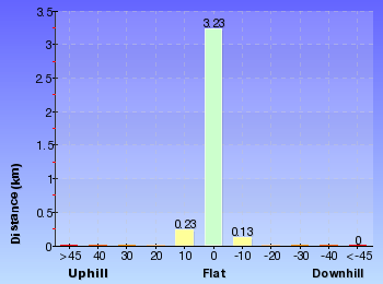
Bateau Bay Beach to Crackneck Beach
And Walk
Bateau Bay Beach to Crackneck Beach


1 hr 15 mins
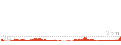
3.4 km Return

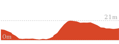
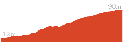
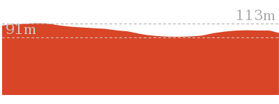
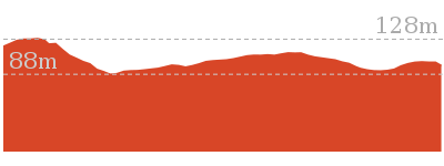
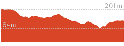
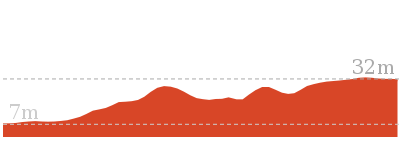
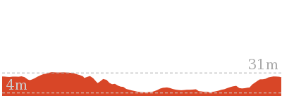
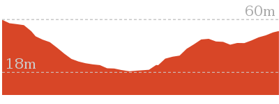
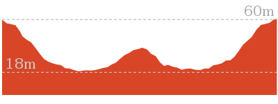
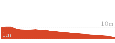
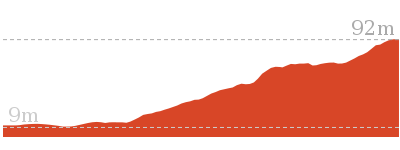
99 m
Experienced only


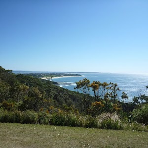
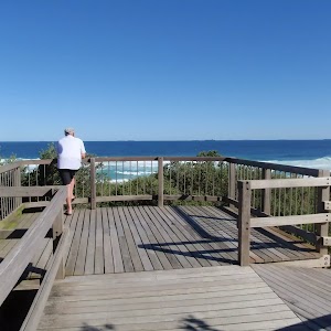
Bateau Bay Beach picnic area and lookout
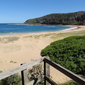
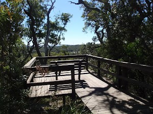
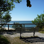
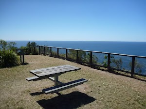
This unnamed picnic area and lookout is within Wyrrabalong National Park, at the intersection of Reserve Dr and Harbour St, Bateau Bay. The picnic area overlooks Bateau Bay and the beach. There are large grass areas, plenty of shade and facilities including picnic tables, garbage bins, and beach access steps. There are beautiful views along the coast and out to sea from the picnic area. There are free electric BBQs at Sutton Reserve, a block further south along Reserve Dr. Takeaway food is available at a small shopping centre near the intersection of Harbour St and Bateau Bay Rd, one block from the picnic area.
(0km) Top of northern Bateau Bay Beach access steps → Bottom of northern Bateau Bay Beach access track

110 m
2 mins
0m
-6m
Moderate track
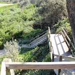
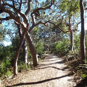
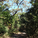
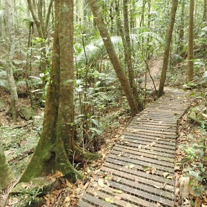
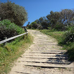
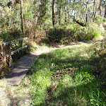
From the intersection, this walk goes down the timber steps, towards the beach. The walk follows the boardwalk and timber steps down the hill until reaching Bateau Bay Beach[1].
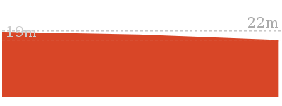
(0.11km) Bottom of northern Bateau Bay Beach access track → Southern end of Bateau Bay Beach
420 m
8 mins
13m
-12m
Hard track
Continue straight: From the bottom of the northern Bateau Bay Beach[2] access stairs, this walk goes south along the beach, keeping the ocean to the left. Towards the southern end of the beach, the walk arrives at the base of some concrete steps, beside a concrete management trail.
Turn left: From the bottom of the southern Bateau Bay[3] Beach access track (beside the concrete management trail), this walk goes south across the sand, keeping the ocean to the left. After a very short distance, the walk arrives at the southern edge of Bateau Bay Beach[4], with a much narrower strip of sand continuing south.
Turn left: From the bottom of the southern Bateau Bay[3] Beach access track (beside the concrete management trail), this walk goes south across the sand, keeping the ocean to the left. After a very short distance, the walk arrives at the southern edge of Bateau Bay Beach[4], with a much narrower strip of sand continuing south.
(0.53km) Southern end of Bateau Bay Beach → Crackneck rockshelf
710 m
13 mins
18m
-17m
Experienced only
Continue straight: From the southern end of Bateau Bay Beach, this walk goes south, along the narrow strip of sand, keeping the ocean to the left. The walk passes a concrete stormwater outlet (to the right) and a short distance later reaches the end of the sandy strip, with some mangrove trees to the left.
Continue straight: From the end of the narrow beach strip, this walk passes some mangrove trees, to the left, and follows the sandy track south, keeping the ocean to the left. After a short distance, the walk reaches the end of the sandy track, at the rockshelf.
Continue straight: From the end of the narrow beach strip, this walk passes some mangrove trees, to the left, and follows the sandy track south, keeping the ocean to the left. After a short distance, the walk reaches the end of the sandy track, at the rockshelf.
(1.24km) Crackneck rockshelf → Crackneck beach
470 m
9 mins
18m
-15m
Experienced only
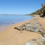
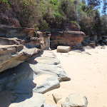
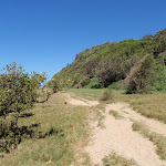
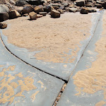
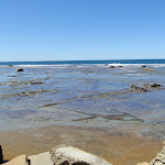
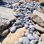
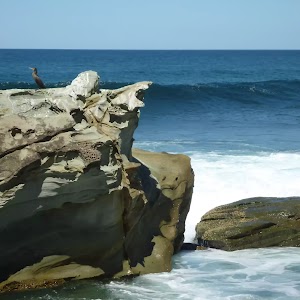
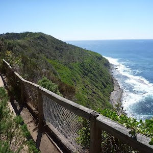
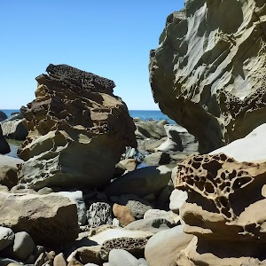
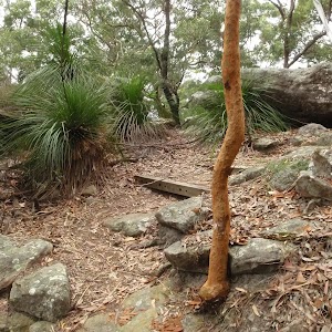
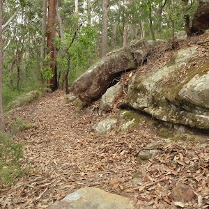
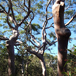
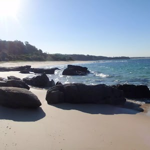
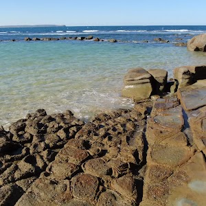
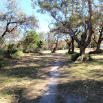
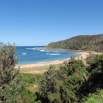
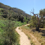
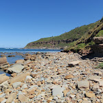
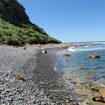
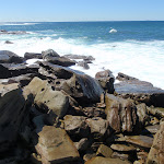
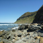
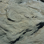
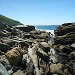
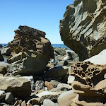
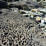
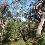
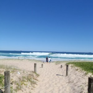
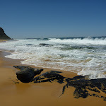
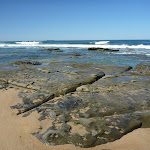
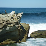
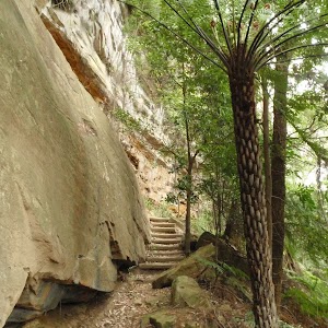
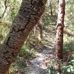
Continue straight: From the end of the sandy track, the walk goes across the rockshelf, following the coastline south, keeping the ocean to the left. There are some interesting textures in the rock, with some regular, angular cracks in places, making for some intriguing scenery. The walk then goes around the headland and continues a short distance to the unnamed beach beneath Crackneck Lookout, covered in rounded fist-sized rocks.
Crackneck Beach
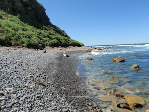
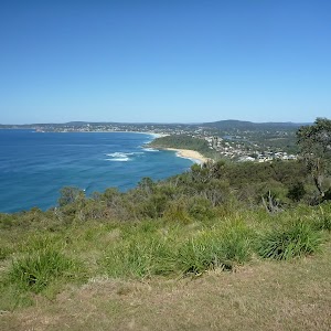
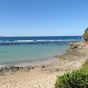
This unnamed beach is below Crackneck Lookout and can be reached with some difficulty by walking along the very rocky shoreline from Forresters Beach, to the south, or from Bateau Bay beach, to the north. The beach is covered in rounded rocks about the size of a fist.
Maps for the Bateau Bay Beach to Crackneck Beach walk
You can download the PDF for this walk to print a map.
These maps below cover the walk and the wider area around the walk, they are worth carrying for safety reasons.
| Gosford | 1:25 000 Map Series | 91312S GOSFORD | NSW-91312S |
| Gosford | 1:100 000 Map Series | 9131 GOSFORD | 9131 |
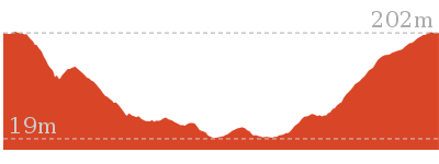
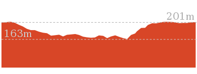
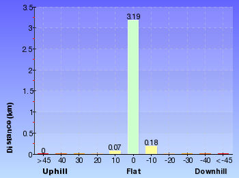
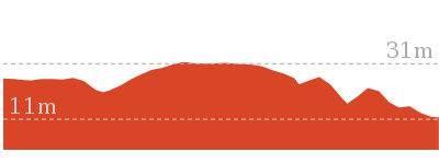
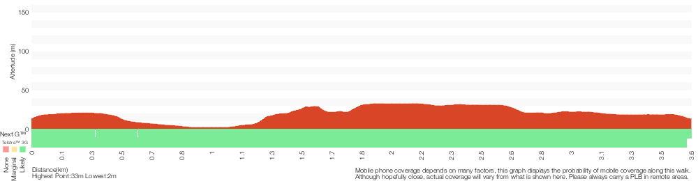
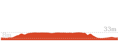
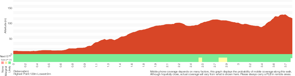
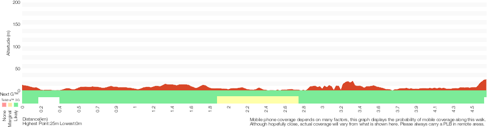
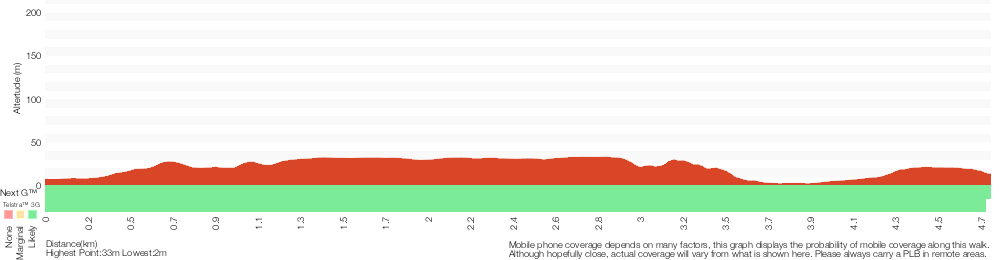
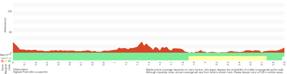
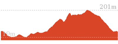
Cross sectional view of the Bateau Bay Beach to Crackneck Beach bushwalking track

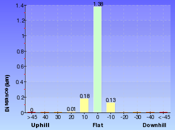
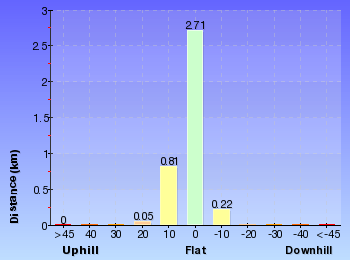
Analysis and summary of the altitude variation on the Bateau Bay Beach to Crackneck Beach
Overview of this walks grade – based on the AS 2156.1 – 2001
Under this standard, a walk is graded based on the most difficult section of the walk.
| Length | 3.4 km | ||
| Time | 1 hr 15 mins | ||
| . | |||
| Grade 5/6 Experienced only |
AS 2156.1 | Gradient | Short steep hills (3/6) |
| Quality of track | Rough unclear track (5/6) | ||
| Signs | Minimal directional signs (4/6) | ||
| Experience Required | Moderate level of bushwalking experience recommended (4/6) | ||
| Weather | Forecast, unforecast storms and severe weather may impact on navigation and safety (4/6) | ||
| Infrastructure | Limited facilities (such as cliffs not fenced, significant creeks not bridged) (4/6) |
Some more details of this walks Grading
Here is a bit more details explaining grading looking at sections of the walk
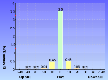
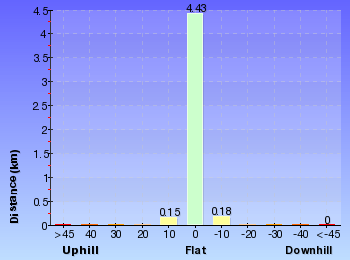
Gradient
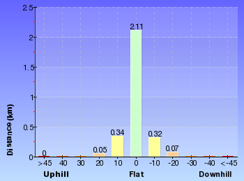
Around 1.1km of this walk has gentle hills with occasional steps, whilst the remaining 570m has short steep hills.
Quality of track
870m of this walk follows a rough unclear track and another 730m follows a rough track, where fallen trees and other obstacles are likely. The remaining (110m) follows a clear and well formed track or trail.
Signs
Around 1.6km of this walk has minimal directional signs, whilst the remaining 110m has directional signs at most intersection.
Experience Required
Around 1.2km of this walk requires some bushwalking experience, whilst the remaining 470m requires a leader a with moderate level of bushwalking experience.
weather
710m of this walk is affected by storms that may impact your navigation and safety and another 530m is not usually affected by severe weather events (that would unexpectedly impact safety and navigation). The remaining (470m) is affected by forecast, unforecast storms and severe weather events that may impact on navigation and safety.
Infrastructure
Around 1.6km of this walk has limited facilities (such as cliffs not fenced, significant creeks not bridged), whilst the remaining 110m has limited facilities (such as not all cliffs fenced).
Similar walks
A list of walks that share part of the track with the Bateau Bay Beach to Crackneck Beach walk.
892 m Circuit
30 mins
Hard track
4.6 km One way
2 hrs
Experienced only
9.1 km Circuit
3 hrs 30 mins
Experienced only
Other Nearby walks
A list of walks that start near the Bateau Bay Beach to Crackneck Beach walk.
1.7 km One way
1 hr 30 mins
Moderate track
3.8 km One way
1 hr 30 mins
Moderate track

646 m One way
15 mins
Moderate track
382 m Return
15 mins
Moderate track
1.6 km One way
45 mins
Moderate track
5.8 km Return
2 hrs 30 mins
Experienced only

166 m Return
10 mins
Very easy
4.8 km Circuit
2 hrs 15 mins
Moderate track
2.9 km One way
1 hr 30 mins
Moderate track
1.2 km Circuit
45 mins
Moderate track
1.5 km One way
45 mins
Moderate track

4.1 km One way
2 hrs
Hard track
Plan your trip to and from the walk here
The Bateau Bay Beach to Crackneck Beach walk starts and ends at the Top of northern Bateau Bay Beach access steps (gps: -33.382053, 151.48403)
Your transport options to Top of northern Bateau Bay Beach access steps are by;
![]() Bus. (get details)
Bus. (get details)
![]() Car. There is free parking available.
Car. There is free parking available.
(get details)


Short URL = http://wild.tl/bbbtcb
Gallery images
There are other downloads I am still working on.
You will probably need to login to access these — still all free.
* KML (google earth file)
* GPX (GPS file)
Special Maps/ brochures
* A3 topo maps
* PDF with Lands Topo map base
* PDF with arial image (and map overlay)
I wanted to get the main site live first, this extra stuff will come in time.
Happy walking
Matt 🙂
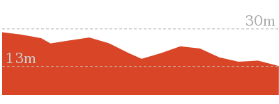
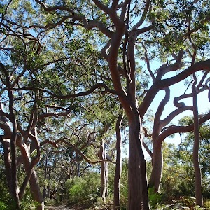
Redgum trail
And Walk
Redgum trail

1 hr 15 mins
3.4 km Circuit
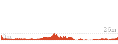
48 m
Moderate track
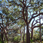
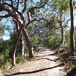
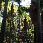
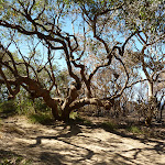
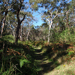
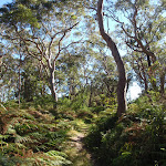
An excellent loop walk through areas of beautiful Sydney Redgums. In several places these twisted trees lean over the track, creating great scenery and atmosphere. Two lookout platforms along the way provide some fantastic views over the surrounding areas and Tuggerah Lake. Much of the walk is on sandy tracks.


(0km) Burrawang car park → Int of Burrawang track and Redgum trail
60 m
1 mins
0m
-1m
Easy track
From the car park on the Central Coast Hwy, aka Wilfred Barret Dr (about 7km north of The Entrance bridge, and about 3km south of the intersection with Main Rd, Noraville. Signposted ‘Wyrrabalong National Park’), the walk passes through the timber fence, passing an information board, to the left, and a picnic table, to the right, and follows the sandy management trail. After a very short distance, the trail arrives at the intersection of the ‘Red Gum Trail’ and the ‘Burrawang Walking Track’.
(0.06km) Int of Burrawang track and Redgum trail → Redgum lookout
1.1 km
19 mins
28m
-6m
Moderate track
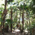
Turn right: From the intersection, the walk follows the ‘Red Gum Trail’ arrow along the wide, level, sandy track. The track climbs a little through a series of bends, passing a couple of ‘Red Gum Trail’ signs. There are some very nice sections of forest along here, with twisted trees leaning over the track. The track continues for some time before arriving at the intersection with the ‘Wetland Trail’.
Turn left: From the intersection, the walk follows the right arrow on the ‘Red Gum Trail’ sign, along the sandy bush track. The track immediately drops through a gully and meanders up the other side. This section of the walk climbs and drops a little as it passes through very nice forest, with twisted tree branches leaning over the trail. The track passes a ‘Red Gum Forest’ information board, to the left, and continues for while to reach a wooden lookout platform with atmospheric views to the north and north-east.
Turn left: From the intersection, the walk follows the right arrow on the ‘Red Gum Trail’ sign, along the sandy bush track. The track immediately drops through a gully and meanders up the other side. This section of the walk climbs and drops a little as it passes through very nice forest, with twisted tree branches leaning over the trail. The track passes a ‘Red Gum Forest’ information board, to the left, and continues for while to reach a wooden lookout platform with atmospheric views to the north and north-east.
Redgum lookout
This unnamed lookout is in the Wyrrabalong National park, north of The Entrance and provides views to the north across part of Tuggerah Lake and Toukley. The lookout is on the Redgum Trail and consists of a fenced wooden platform with a seat. This is a nice, atmospheric spot to take a break on the walk.
(1.14km) Redgum lookout → Tuggerah lake lookout
710 m
11 mins
4m
-4m
Moderate track
Turn left: From the lookout, the walk follows the sandy bush track to the west, leaving the lookout platform behind and to the right. The sandy track undulates through nice forest and bends to the left (south) and continues for some distance, offering glimpses of Tuggerah lake, to the right, and the ocean, to the left. The track then reaches another wooden lookout platform, a little to the right of the track, with great views to the west, over Tuggerah lake.
Tuggerah Lake lookout
This unnamed lookout provides views across Tuggerah Lake, north of The Entrance. The lookout is on the Redgum Trail and consists of a fenced wooden platform with a seat. the beautiful views and atmosphere make this a great spot for a break during a walk in the area.
(1.85km) Tuggerah lake lookout → Int of Lilly Pilly loop and Redgum track
410 m
7 mins
4m
-3m
Moderate track
Continue straight: From the lookout, the walk follows the sandy bush track to the south, leaving the lookout platform behind and to the right. This section of the walk also undulates through nice forest on a sandy track. The walk then reaches the intersection with ‘The Lilly Pilly Loop Trail’.
(2.27km) Int of Lilly Pilly loop and Redgum track → Int of Lilly Pilly loop and Burrawang track
210 m
4 mins
1m
-3m
Moderate track
Veer left: From the intersection, the walk follows the left arrow on the ‘Lilly Pilly Loop Trail’ sign, along the sandy bush track. The track immediately drops through a gully, then winds through some nice forest for a short distance before arriving at the intersection with the ‘Burrawang Walking Track’.
(2.48km) Int of Lilly Pilly loop and Burrawang track → Burrawang car park
970 m
17 mins
11m
-31m
Moderate track
Turn left: From the intersection, the walk follows the ‘Burrawang Walking Track’ sign, steeply down the hill and along the sandy bush track. After descending for a short distance, the track levels out before meandering through some nice forest. The thick vegetation is very closed in at times. The track passes a ‘Burrawang Walking Track’ signpost, to the left, and continues to wind through the nice forest to reach the signposted intersection with the ‘Red Gum Trail’.
Continue straight: From the intersection, the walk follows the sandy management trail up the hill, towards the road. After a very short distance the walk climbs some wooden steps, passes a picnic table, to the left, an information board, to the right, and passes through a timber fence to reach the car park on the Central Coast Hwy, aka Wilfred Barret Dr (about 7km north of The Entrance bridge, and about 3km south of the intersection with Main Rd, Noraville. Signposted ‘Wyrrabalong National Park’).
Continue straight: From the intersection, the walk follows the sandy management trail up the hill, towards the road. After a very short distance the walk climbs some wooden steps, passes a picnic table, to the left, an information board, to the right, and passes through a timber fence to reach the car park on the Central Coast Hwy, aka Wilfred Barret Dr (about 7km north of The Entrance bridge, and about 3km south of the intersection with Main Rd, Noraville. Signposted ‘Wyrrabalong National Park’).
Maps for the Redgum trail walk
You can download the PDF for this walk to print a map.
These maps below cover the walk and the wider area around the walk, they are worth carrying for safety reasons.
| Toukley | 1:25 000 Map Series | 92313N TOUKLEY | NSW-92313N |
| Lake Macquarie | 1:100 000 Map Series | 9231 LAKE MACQUARIE | 9231 |
Cross sectional view of the Redgum trail bushwalking track

Analysis and summary of the altitude variation on the Redgum trail
Overview of this walks grade – based on the AS 2156.1 – 2001
Under this standard, a walk is graded based on the most difficult section of the walk.
| Length | 3.4 km | ||
| Time | 1 hr 15 mins | ||
| . | |||
| Grade 3/6 Moderate track |
AS 2156.1 | Gradient | Short steep hills (3/6) |
| Quality of track | Formed track, with some branches and other obstacles (3/6) | ||
| Signs | Directional signs along the way (3/6) | ||
| Experience Required | No experience required (1/6) | ||
| Weather | Weather generally has little impact on safety (1/6) | ||
| Infrastructure | Limited facilities, not all cliffs are fenced (3/6) |
Some more details of this walks Grading
Here is a bit more details explaining grading looking at sections of the walk
Gradient
Around 1.8km of this walk has short steep hills, whilst the remaining 1.7km has gentle hills with occasional steps.
Quality of track
Around 2.5km of this walk follows a clear and well formed track or trail, whilst the remaining 910m follows a formed track, with some branches and other obstacles.
Signs
Around 2.7km of this walk has directional signs at most intersection, whilst the remaining 740m is clearly signposted.
Experience Required
This whole walk, 3.4km requires no previous bushwalking experience.
weather
This whole walk, 3.4km is not usually affected by severe weather events (that would unexpectedly impact safety and navigation).
Infrastructure
Around 1.9km of this walk is close to useful facilities (such as fenced cliffs and seats), whilst the remaining 1.6km has limited facilities (such as not all cliffs fenced).
Similar walks
A list of walks that share part of the track with the Redgum trail walk.
3.1 km Return
1 hr 15 mins
Moderate track

3.6 km Circuit
1 hr 15 mins
Moderate track
4.8 km One way
1 hr 45 mins
Moderate track
6.9 km Circuit
2 hrs 15 mins
Moderate track

Other Nearby walks
A list of walks that start near the Redgum trail walk.
1.8 km Return
45 mins
Moderate track

2.5 km Circuit
1 Hr
Hard track
2.2 km Return
1 Hr
Moderate track
1.6 km Return
45 mins
Hard track
762 m Return
30 mins
Very easy
150 m Return
15 mins
Easy track
2.6 km Return
1 Hr
Hard track
3.8 km One way
1 hr 30 mins
Moderate track
444 m Return
10 mins
Easy track
136 m Return
3 mins
Very easy
892 m Circuit
30 mins
Hard track

3.4 km Return
1 hr 15 mins
Experienced only
Plan your trip to and from the walk here
The Redgum trail walk starts and ends at the Burrawang car park (gps: -33.293676, 151.54662)
Your main transport option to Burrawang car park is by;
![]() Car. There is free parking available.
Car. There is free parking available.
(get details)
Short URL = http://wild.tl/24
Gallery images
There are other downloads I am still working on.
You will probably need to login to access these — still all free.
* KML (google earth file)
* GPX (GPS file)
Special Maps/ brochures
* A3 topo maps
* PDF with Lands Topo map base
* PDF with arial image (and map overlay)
I wanted to get the main site live first, this extra stuff will come in time.
Happy walking
Matt 🙂
Lillypilly Loop Trail
And Walk
Lillypilly Loop Trail

1 hr 15 mins
3.6 km Circuit
62 m
Moderate track
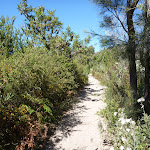
This beautiful loop walk passes through a great variety of forest scenery, including some lovely rainforest, dominated by cabbage palms and other trees. There are some beautiful views across Tuggerah Lake, and parts of the track feature twisted Sydney Redgums leaning over the track, and the shorter palm-like Burrawang (a species of cycad). Much of the walk is on sandy tracks, with sections of timber boarding to control erosion.


(0km) South car park → Int of Lilly Pilly loop and Sth Lilly Pilly access trail
80 m
2 mins
6m
0m
Moderate track
From the car park on the Central Coast Hwy, aka Wilfred Barret Dr (about 5.5 km north of The Entrance bridge, and about 4.6km south of the intersection with Main Rd, Noraville. Signposted ‘Wyrrabalong National Park’), the walk goes around a gate, passes an information board and ‘Lilly Pilly Loop Trail’ sign, and follows the management trail up the hill. The trail soon bends to the left and arrives at an intersection, marked with a ‘Lilly Pilly Loop Link Trail’ sign.
(0.08km) Int of Lilly Pilly loop and Sth Lilly Pilly access trail → Tuggerah lake vista
820 m
14 mins
3m
-19m
Moderate track
Continue straight: From the intersection, the walk follows the sandy bush track, going up the hill, away from the nearby road. The track runs along a ridge line, through relatively dry forest for a while, before dropping a little, into moist littoral rainforest. The walk meanders through this beautiful area of rainforest, passing a ‘Rainforests’ information board, to the left, and then emerges to a nice vista at the edge of Tuggerah lake.
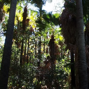
Lilly Pilly loop rainforest

This area of littoral rainforest is on the Lilly Pilly loop walk, in Wyrrabalong National Park, north of The Entrance. This small remnant of rainforest is dominated by cabbage palms, corkwoods and tuckeroos. There are nice views across Tuggerah lake from the edge of the forest as well.
Tuggerah Lake vista

This informal, unnamed spot at the edge of Tuggerah Lake, north of The Entrance, has beautiful views across the lake. These views, combined with the nearby area of rainforest, provide beautiful scenery on walks in the area.
(0.9km) Tuggerah lake vista → Int of Lilly Pilly loop and Redgum track
1.2 km
21 mins
43m
-13m
Moderate track
Veer right: From the lakeside vista, the walk follows the bush track north, keeping Tuggerah lake to the left. The track follows the lake edge for a short distance before climbing away to the right. This section of the track undulates through quite moist forest, with some great views back across the lake, then passes some timber retaining walls. From here, the walk undulates through drier forest for some distance, with sections of erosion control board walkway, to reach the intersection with the ‘Red Gum Trail’.
(2.09km) Int of Lilly Pilly loop and Redgum track → Int of Lilly Pilly loop and Nth Lilly Pilly access trail
650 m
12 mins
3m
-14m
Moderate track
Turn right: From the intersection, the walk follows the left arrow on the ‘Lilly Pilly Loop Trail’ sign, along the sandy bush track. The track immediately drops through a gully, then winds through some nice forest for a short distance before arriving at the intersection with the ‘Burrawang Walking Track’.
Veer right: From the intersection, the walk follows the sandy bush track up the hill, leaving the ‘Lilly Pilly Loop Trail’ sign on the right. After a while the track descends, with sections of erosion control board walkway, through nice forest, before reaching the intersection signposted with ‘Lilly Pilly Loop Link Trail’.
Veer right: From the intersection, the walk follows the sandy bush track up the hill, leaving the ‘Lilly Pilly Loop Trail’ sign on the right. After a while the track descends, with sections of erosion control board walkway, through nice forest, before reaching the intersection signposted with ‘Lilly Pilly Loop Link Trail’.
(2.74km) Int of Lilly Pilly loop and Nth Lilly Pilly access trail → South car park
860 m
15 mins
7m
-15m
Moderate track
Turn right: From the intersection, the walk follows the ‘Lilly Pilly Loop Link Trail’ arrow, along the narrow bush track, going up the hill. This section of track meanders through an interesting mixture of patches of littoral rainforest and some drier forest. One very sandy section of the track is held in place by low, timber retaining walls. The walk continues, eventually climbing a little through thick, vine covered vegetation, to reach an intersection marked with a ‘Lilly Pilly Loop Link Trail’ sign.
Turn left: From the intersection, the walk follows the level, sandy management trail towards the nearby road (opposite direction to the signpost arrow). After a short distance, the trail bends to the right and goes down hill a little. The walk passes an information board and ‘Lilly Pilly Loop Trail’ sign before going around a gate and arriving at the car park on the Central Coast Hwy, aka Wilfred Barret Dr (about 5.5 km north of The Entrance bridge, and about 4.6km south of the intersection with Main Rd, Noraville. Signposted ‘Wyrrabalong National Park’).
Turn left: From the intersection, the walk follows the level, sandy management trail towards the nearby road (opposite direction to the signpost arrow). After a short distance, the trail bends to the right and goes down hill a little. The walk passes an information board and ‘Lilly Pilly Loop Trail’ sign before going around a gate and arriving at the car park on the Central Coast Hwy, aka Wilfred Barret Dr (about 5.5 km north of The Entrance bridge, and about 4.6km south of the intersection with Main Rd, Noraville. Signposted ‘Wyrrabalong National Park’).
Maps for the Lillypilly Loop Trail walk
You can download the PDF for this walk to print a map.
These maps below cover the walk and the wider area around the walk, they are worth carrying for safety reasons.
| Toukley | 1:25 000 Map Series | 92313N TOUKLEY | NSW-92313N |
| Lake Macquarie | 1:100 000 Map Series | 9231 LAKE MACQUARIE | 9231 |
Cross sectional view of the Lillypilly Loop Trail bushwalking track
Analysis and summary of the altitude variation on the Lillypilly Loop Trail
Overview of this walks grade – based on the AS 2156.1 – 2001
Under this standard, a walk is graded based on the most difficult section of the walk.
| Length | 3.6 km | ||
| Time | 1 hr 15 mins | ||
| . | |||
| Grade 3/6 Moderate track |
AS 2156.1 | Gradient | Short steep hills (3/6) |
| Quality of track | Formed track, with some branches and other obstacles (3/6) | ||
| Signs | Directional signs along the way (3/6) | ||
| Experience Required | Some bushwalking experience recommended (3/6) | ||
| Weather | Weather generally has little impact on safety (1/6) | ||
| Infrastructure | Limited facilities, not all cliffs are fenced (3/6) |
Some more details of this walks Grading
Here is a bit more details explaining grading looking at sections of the walk
Gradient
Around 2.6km of this walk has short steep hills, whilst the remaining 990m has gentle hills with occasional steps.
Quality of track
Around 2.4km of this walk follows a clear and well formed track or trail, whilst the remaining 1.2km follows a formed track, with some branches and other obstacles.
Signs
Around 3.4km of this walk has directional signs at most intersection, whilst the remaining 160m is clearly signposted.
Experience Required
Around 2.4km of this walk requires some bushwalking experience, whilst the remaining 1.2km requires no previous bushwalking experience.
weather
This whole walk, 3.6km is not usually affected by severe weather events (that would unexpectedly impact safety and navigation).
Infrastructure
This whole walk, 3.6km has limited facilities (such as not all cliffs fenced).
Similar walks
A list of walks that share part of the track with the Lillypilly Loop Trail walk.
1.8 km Return
45 mins
Moderate track
3.4 km Circuit
1 hr 15 mins
Moderate track
4.8 km One way
1 hr 45 mins
Moderate track
6.9 km Circuit
2 hrs 15 mins
Moderate track
Other Nearby walks
A list of walks that start near the Lillypilly Loop Trail walk.
3.1 km Return
1 hr 15 mins
Moderate track
2.5 km Circuit
1 Hr
Hard track
2.2 km Return
1 Hr
Moderate track
1.6 km Return
45 mins
Hard track
762 m Return
30 mins
Very easy
150 m Return
15 mins
Easy track
2.6 km Return
1 Hr
Hard track
3.8 km One way
1 hr 30 mins
Moderate track
892 m Circuit
30 mins
Hard track
3.4 km Return
1 hr 15 mins
Experienced only
4.6 km One way
2 hrs
Experienced only
1.7 km One way
1 hr 30 mins
Moderate track
Plan your trip to and from the walk here
The Lillypilly Loop Trail walk starts and ends at the South car park (gps: -33.300644, 151.53294)
Your main transport option to South car park is by;
![]() Car. There is free parking available.
Car. There is free parking available.
(get details)
Short URL = http://wild.tl/25
Gallery images
There are other downloads I am still working on.
You will probably need to login to access these — still all free.
* KML (google earth file)
* GPX (GPS file)
Special Maps/ brochures
* A3 topo maps
* PDF with Lands Topo map base
* PDF with arial image (and map overlay)
I wanted to get the main site live first, this extra stuff will come in time.
Happy walking
Matt 🙂
Wyrrabalong Coast Walking Track
And Walk
Wyrrabalong Coast Walking Track

1 hr 30 mins
3.8 km One way
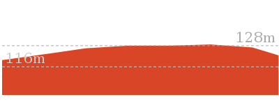
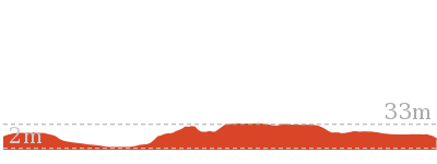
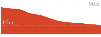
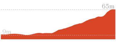
178 m
Moderate track
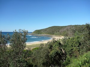
An excellent walk in the southern section of Wyrrabalong National Park. This walk runs through a long thin strip of beautiful coastal forest, with fantastic views of the coastline from many vantage points along the way. The two main lookouts along the way, Crackneck and Wyrrabalong, have stunning views and would be great spots to stop for a picnic lunch.


(0km) Entrance of Blue Lagoon Beach Resort → Top of northern Bateau Bay Beach access steps
520 m
8 mins
4m
-2m
Moderate track
From the entrance to the Blue Lagoon Beach Resort (at the intersection of Bateau Bay Rd and Moronga St, Bateau Bay), this walk follows the sandy track as it goes behind the wooden fence and runs alongside Bateau Bay Rd, keeping the road to the right. After a short distance the track swings away from the road and meanders through the trees for a short distance, passing an old concrete tank, to the left, and ignoring sidetracks to ocean viewpoints etc. The walk then turns right at an intersection near a viewpoint, looking over the caravan park. From here the walk follows the sandy bush track directly away fro the nearby caravan park, ignores a bush track to the left, and soon enters the picnic area and reaches an intersection beside the top of the wooden beach access steps.
Bateau Bay Beach picnic area and lookout
This unnamed picnic area and lookout is within Wyrrabalong National Park, at the intersection of Reserve Dr and Harbour St, Bateau Bay. The picnic area overlooks Bateau Bay and the beach. There are large grass areas, plenty of shade and facilities including picnic tables, garbage bins, and beach access steps. There are beautiful views along the coast and out to sea from the picnic area. There are free electric BBQs at Sutton Reserve, a block further south along Reserve Dr. Takeaway food is available at a small shopping centre near the intersection of Harbour St and Bateau Bay Rd, one block from the picnic area.
(0.52km) Top of northern Bateau Bay Beach access steps → South end of Bateau Bay Beach picnic area
100 m
2 mins
1m
-1m
Moderate track
Continue straight: Starting from the track intersection beside the beach access steps, this walk follows the faint track a very short distance across the picnic area, keeping Reserve Dr to the right. The walk soon arrives at some seats and an open viewing area, to the left, with stunning views across the water.
Continue straight: From the viewpoint, this walk goes south across the picnic area, keeping Reserve Dr to the right. The walk passes a fenced viewing area just before reaching an intersection at the end of the picnic area, with a concrete beach-access track to the left.
Continue straight: From the viewpoint, this walk goes south across the picnic area, keeping Reserve Dr to the right. The walk passes a fenced viewing area just before reaching an intersection at the end of the picnic area, with a concrete beach-access track to the left.
(0.62km) South end of Bateau Bay Beach picnic area → Rushby St car park
260 m
5 mins
10m
-1m
Moderate track
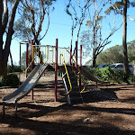
Continue straight: From the intersection, this walk follows the bush track past the ‘Wyrrabalong National Park Service Trail Walkers Only’ sign, keeping Reserve Dr to the right. This walk passes through a nice strip of forest, passing a number of fenced viewing points, to the left, with great views out to sea. After a while, the walk emerges at another picnic area, next to a toilet block, and continues across the picnic area and car park, reaching an intersection signposted ‘Coast Track’, with a gated concrete driveway and beach access steps to the left.
Southern Bateau Bay beach picnic area
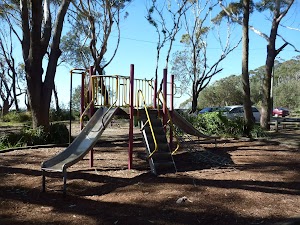
This picnic area, near the intersection of Reserve Dr and Rushby St, Bateau Bay, overlooks the southern end of Bateau Bay and the beach. The facilities include toilets, picnic tables, garbage bins and some slides for the kids. There are great views along the coast and out to sea. There is plenty of shade.
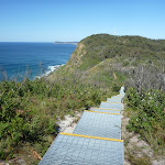
(0.88km) Rushby St car park → Crackneck Lookout
1.3 km
29 mins
88m
-12m
Moderate track
Continue straight: From the intersection, the walk follows the ‘Coast Track’ arrow along the bush track, keeping Reserve Dr to the right. The walk climbs gently and passes a number of side tracks on either side, which go a short distance to ocean viewing spots or the nearby road. After a while, the walk reaches an intersection in the middle of a grassy clearing, with more ocean views.
Continue straight: From the intersection, the walk follows the bush track south, keeping Reserve Dr to the right. The walk soon passes a bench seat with a commemorative plaque, and continues through the bush on the sandy track. Ignoring a track to the right (which goes to the nearby street), the walk continues along sections of track with retaining boards, for some time before arriving beside Hilltop St. The walk continues along the bush track close to Hilltop St, going along sections of boardwalk before climbing some wooden steps and emerging at the northern edge of Crackneck Lookout (at the end of Hilltop St).
Continue straight: From the intersection, the walk follows the bush track south, keeping Reserve Dr to the right. The walk soon passes a bench seat with a commemorative plaque, and continues through the bush on the sandy track. Ignoring a track to the right (which goes to the nearby street), the walk continues along sections of track with retaining boards, for some time before arriving beside Hilltop St. The walk continues along the bush track close to Hilltop St, going along sections of boardwalk before climbing some wooden steps and emerging at the northern edge of Crackneck Lookout (at the end of Hilltop St).
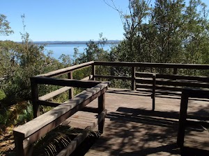
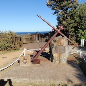
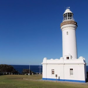
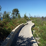
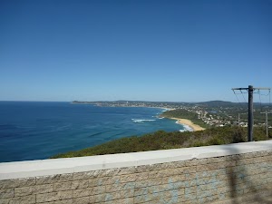
Crackneck Lookout
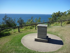
This lookout, at the end of Hilltop St, Bateau Bay, has stunning views up and down the coastline, and out to sea. There are picnic tables and an information board about marine mammals. There is a hangliding launch spot beside the lookout.
(2.17km) Crackneck Lookout → End of Crackneck management trail
270 m
5 mins
6m
-11m
Easy track
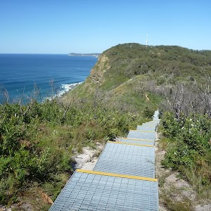
Veer right: From the southern edge of Crackneck Lookout (at the end of Hilltop St), the walk goes around the gate and follows the ‘Coast Track’ arrow, along the old management trail toward ‘Wyrrabalong Lookout’, keeping the ocean to the left. The walk passes a National Park information board, to the left, then takes the right-hand branch at a prominent fork. From here, the walk follows the main trail, ignoring numerous short side tracks (some of which lead to clifftop viewpoints) until reaching the end of the management trail and the start of a sandy bush track, to the right, marked with some timber posts.
(2.45km) End of Crackneck management trail → Int of Coast Track and southern Stephenson Rd access track
240 m
6 mins
19m
0m
Moderate track
Veer right: From the junction at the end of the management trail, this walk follows the sandy bush track marked with some timber posts. The track goes for a very short distance to an intersection, with another sandy bush track to the right, marked with several wooden posts and a signpost (indicating walkers are permitted but no dogs or motorbikes).
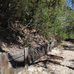
Continue straight: From the intersection, this walk follows the sandy bush track south, leaving the signpost behind on the right. The track passes through lovely bush with plenty of grass trees and, after a short distance, reaches an intersection with another sandy bush track, to the right, at the start of some low sandstone retaining walls.
Continue straight: From the intersection, this walk follows the sandy bush track south, leaving the signpost behind on the right. The track passes through lovely bush with plenty of grass trees and, after a short distance, reaches an intersection with another sandy bush track, to the right, at the start of some low sandstone retaining walls.
(2.69km) Int of Coast Track and southern Stephenson Rd access track → End of Stephenson Rd
130 m
2 mins
1m
-6m
Moderate track
Turn right: From the intersection, this walk follows the sandy bush track away from the ocean, towards the large water tanks. The track widens to a management trail and passes the tanks, to the right, and continues down the hill, passing around a gate, to the end of Stephenson Rd, Bateau Bay.
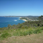
(2.69km) Int of Coast Track and southern Stephenson Rd access track → Wyrrabalong Lookout
920 m
20 mins
43m
-32m
Moderate track
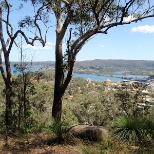
Veer left: From the intersection, the walk follows the sandy bush track south, keeping the ocean to the left. Initially the track has low sandstone retaining walls on either side. The track soon passes a ‘Coastal Heathlands’ information board and continues along the top of a ridge with extensive views out to sea, and inland, before going down a long set of metal stairs. The walk then passes through a section of thick heath, before emerging briefly to more ocean views at a fenced viewpoint. The track continues for some distance, with occasional ocean views, climbing several sets of wooden steps before arriving at the Wyrrabalong Lookout.
Wyrrabalong Lookout and Cromarty Hill
This lookout and picnic area is on Cromarty Hill, near the end of Cromarty Hill Rd, Forresters Beach. There are picnic tables and fantastic views from the lookout point, as well as the concrete roof platform beside the large communications tower. There is a hang gliding launch spot beside the lookout.
(3.61km) Wyrrabalong Lookout → End of Cromarty Hill Rd
190 m
4 mins
7m
-13m
Moderate track
Veer right: From Wyrrabalong Lookout, this walk goes across the grassy area, passing a trig point (to the left) and following the old management trail between the communications tower and satellite dish. There are great views over Forresters Beach from the concrete platform on top of the building, next to the tower. The walk then goes down the hill for a short distance, passing around a gate, signposted ‘Wyrrabalong National Park’, and arriving at the end of Cromarty Hill Rd.
Maps for the Wyrrabalong Coast Walking Track walk
You can download the PDF for this walk to print a map.
These maps below cover the walk and the wider area around the walk, they are worth carrying for safety reasons.
| Gosford | 1:25 000 Map Series | 91312S GOSFORD | NSW-91312S |
| Gosford | 1:100 000 Map Series | 9131 GOSFORD | 9131 |
Cross sectional view of the Wyrrabalong Coast Walking Track bushwalking track
Analysis and summary of the altitude variation on the Wyrrabalong Coast Walking Track
Overview of this walks grade – based on the AS 2156.1 – 2001
Under this standard, a walk is graded based on the most difficult section of the walk.
| Length | 3.8 km | ||
| Time | 1 hr 30 mins | ||
| . | |||
| Grade 3/6 Moderate track |
AS 2156.1 | Gradient | Short steep hills (3/6) |
| Quality of track | Formed track, with some branches and other obstacles (3/6) | ||
| Signs | Directional signs along the way (3/6) | ||
| Experience Required | No experience required (1/6) | ||
| Weather | Weather generally has little impact on safety (1/6) | ||
| Infrastructure | Limited facilities, not all cliffs are fenced (3/6) |
Some more details of this walks Grading
Here is a bit more details explaining grading looking at sections of the walk
Gradient
1.8km of this walk has short steep hills and another 1.6km has gentle hills with occasional steps. The remaining (380m) is flat with no steps.
Quality of track
Around 3.2km of this walk follows a formed track, with some branches and other obstacles, whilst the remaining 560m follows a clear and well formed track or trail.
Signs
Around 2.6km of this walk has directional signs at most intersection, whilst the remaining 1.2km is clearly signposted.
Experience Required
This whole walk, 3.8km requires no previous bushwalking experience.
weather
This whole walk, 3.8km is not usually affected by severe weather events (that would unexpectedly impact safety and navigation).
Infrastructure
Around 3.6km of this walk is close to useful facilities (such as fenced cliffs and seats), whilst the remaining 240m has limited facilities (such as not all cliffs fenced).
Similar walks
A list of walks that share part of the track with the Wyrrabalong Coast Walking Track walk.
382 m Return
15 mins
Moderate track
646 m One way
15 mins
Moderate track
892 m Circuit
30 mins
Hard track
1.6 km One way
45 mins
Moderate track
1.7 km One way
1 hr 30 mins
Moderate track
9.1 km Circuit
3 hrs 30 mins
Experienced only
Other Nearby walks
A list of walks that start near the Wyrrabalong Coast Walking Track walk.
3.4 km Return
1 hr 15 mins
Experienced only
4.6 km One way
2 hrs
Experienced only
5.8 km Return
2 hrs 30 mins
Experienced only
166 m Return
10 mins
Very easy
4.8 km Circuit
2 hrs 15 mins
Moderate track
2.9 km One way
1 hr 30 mins
Moderate track
1.2 km Circuit
45 mins
Moderate track
1.5 km One way
45 mins
Moderate track
4.1 km One way
2 hrs
Hard track

2 km Return
1 Hr
Moderate track
890 m Return
30 mins
Easy track
1.6 km Circuit
45 mins
Easy track
Plan your trip to and from the walk here
The Wyrrabalong Coast Walking Track walk starts at the Entrance of Blue Lagoon Beach Resort (gps: -33.378107, 151.48415)
Your transport options to Entrance of Blue Lagoon Beach Resort are by;
![]() Bus. (get details)
Bus. (get details)
![]() Car. There is free parking available.
Car. There is free parking available.
(get details)
The Wyrrabalong Coast Walking Track ends at the End of Cromarty Hill Rd (gps: -33.405263, 151.47447)
Your transport options to End of Cromarty Hill Rd are by;
![]() Bus. (get details)
Bus. (get details)
![]() Car. There is free parking available.
Car. There is free parking available.
(get details)
Short URL = http://wild.tl/wcwt
Gallery images
There are other downloads I am still working on.
You will probably need to login to access these — still all free.
* KML (google earth file)
* GPX (GPS file)
Special Maps/ brochures
* A3 topo maps
* PDF with Lands Topo map base
* PDF with arial image (and map overlay)
I wanted to get the main site live first, this extra stuff will come in time.
Happy walking
Matt 🙂
Wyrrabalong Shoreline walk
And Walk
Wyrrabalong Shoreline walk

2 hrs
4.6 km One way
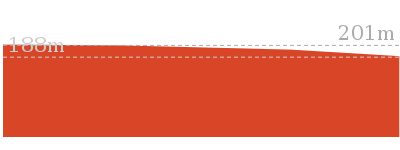
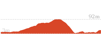
183 m
Experienced only
This walk runs along the shoreline from Bateau Bay to Forresters Beach, in the southern section of Wyrrabalong National Park. The walk is very exposed to the ocean and should not be done at high tide or during rough seas. Much of the shoreline is strewn with boulders, which makes the walking harder but makes the scenery more interesting. The shapes and textures of the boulders, combined with the steep hills and low cliffs of the coastline, plus the uninterrupted ocean views, combine to give quite dramatic scenery and atmosphere for the walk. Consider making a loop walk by returning on the Wyrrabalong Coast Walking Track.* This walk passes through very remote areas and sections have no visible track. At least one person in your group should have training and experience in off track walking and navigation. Even with these notes and a GPS these extra skills and equipment are required.


Bateau Bay Beach picnic area and lookout
This unnamed picnic area and lookout is within Wyrrabalong National Park, at the intersection of Reserve Dr and Harbour St, Bateau Bay. The picnic area overlooks Bateau Bay and the beach. There are large grass areas, plenty of shade and facilities including picnic tables, garbage bins, and beach access steps. There are beautiful views along the coast and out to sea from the picnic area. There are free electric BBQs at Sutton Reserve, a block further south along Reserve Dr. Takeaway food is available at a small shopping centre near the intersection of Harbour St and Bateau Bay Rd, one block from the picnic area.
(0km) Top of northern Bateau Bay Beach access steps → Bottom of northern Bateau Bay Beach access track
110 m
2 mins
0m
-6m
Moderate track
From the intersection, this walk goes down the timber steps, towards the beach. The walk follows the boardwalk and timber steps down the hill until reaching Bateau Bay Beach[1].
(0.11km) Bottom of northern Bateau Bay Beach access track → Crackneck rockshelf
1.1 km
21 mins
31m
-29m
Experienced only
Continue straight: From the bottom of the northern Bateau Bay Beach[2] access stairs, this walk goes south along the beach, keeping the ocean to the left. Towards the southern end of the beach, the walk arrives at the base of some concrete steps, beside a concrete management trail.
Turn left: From the bottom of the southern Bateau Bay[3] Beach access track (beside the concrete management trail), this walk goes south across the sand, keeping the ocean to the left. After a very short distance, the walk arrives at the southern edge of Bateau Bay Beach[4], with a much narrower strip of sand continuing south.
Continue straight: From the southern end of Bateau Bay Beach, this walk goes south, along the narrow strip of sand, keeping the ocean to the left. The walk passes a concrete stormwater outlet (to the right) and a short distance later reaches the end of the sandy strip, with some mangrove trees to the left.
Continue straight: From the end of the narrow beach strip, this walk passes some mangrove trees, to the left, and follows the sandy track south, keeping the ocean to the left. After a short distance, the walk reaches the end of the sandy track, at the rockshelf.
(1.24km) Crackneck rockshelf → Crackneck beach
470 m
9 mins
18m
-15m
Experienced only
Continue straight: From the end of the sandy track, the walk goes across the rockshelf, following the coastline south, keeping the ocean to the left. There are some interesting textures in the rock, with some regular, angular cracks in places, making for some intriguing scenery. The walk then goes around the headland and continues a short distance to the unnamed beach beneath Crackneck Lookout, covered in rounded fist-sized rocks.
Crackneck Beach
This unnamed beach is below Crackneck Lookout and can be reached with some difficulty by walking along the very rocky shoreline from Forresters Beach, to the south, or from Bateau Bay beach, to the north. The beach is covered in rounded rocks about the size of a fist.
(1.71km) Crackneck beach → Bottom of Henrys Rd beach access
2.8 km
1 Hr
116m
-120m
Experienced only
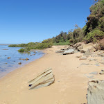
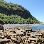
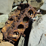
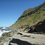
Continue straight: From the unnamed beach beneath Crackneck Lookout, this walk follows the coastline south, keeping the ocean to the left. The walk goes over the rocky, boulder covered shoreline for quite a while, with a lot of rock hopping involved. There is only a narrow strip between the water and the steep hills, to the right, and great care should be exercised. The imposing hills, interesting textures and shapes in the rocks, and the crashing waves all combine to provide fantastic scenery and atmosphere. A fair number of old engine blocks and other car parts are lying in the rocks, rusting away slowly. The walk eventually reaches the sandy, northern end of Forresters Beach. Note: This section of the walk may be impassible at high tide or during high seas.
Continue straight: From the northern end of Forresters Beach, this walk goes south along the beach, keeping the ocean to the left. After a while, the walk reaches the bottom of the Henrys Rd beach access trail, marked by a sign indicating dogs are allowed to the south but not to the north.
Continue straight: From the northern end of Forresters Beach, this walk goes south along the beach, keeping the ocean to the left. After a while, the walk reaches the bottom of the Henrys Rd beach access trail, marked by a sign indicating dogs are allowed to the south but not to the north.
Forresters Beach
Forresters Beach is the name of a township and beach on the Central Coast of NSW. There are public toilets and a beach access path near the intersection of Crystal St and Kalakau Ave, and a beach access path near the bottom of Henrys Rd.
(4.53km) Bottom of Henrys Rd beach access → Int of South Scenic Rd and Henrys Rd
80 m
2 mins
18m
0m
Moderate track
Turn right: From Forresters Beach, this walk passes the sign indicating dogs are allowed to the south but not to the north, and follows the management trail steeply up the hill. The walk goes up the boarded trail, passing a shower area to the left, and goes over the low gate to reach South Scenic Rd, near the intersection with Henrys Rd.
Maps for the Wyrrabalong Shoreline walk walk
You can download the PDF for this walk to print a map.
These maps below cover the walk and the wider area around the walk, they are worth carrying for safety reasons.
| Gosford | 1:25 000 Map Series | 91312S GOSFORD | NSW-91312S |
| Gosford | 1:100 000 Map Series | 9131 GOSFORD | 9131 |
Cross sectional view of the Wyrrabalong Shoreline walk bushwalking track
Analysis and summary of the altitude variation on the Wyrrabalong Shoreline walk
Overview of this walks grade – based on the AS 2156.1 – 2001
Under this standard, a walk is graded based on the most difficult section of the walk.
| Length | 4.6 km | ||
| Time | 2 hrs | ||
| . | |||
| Grade 5/6 Experienced only |
AS 2156.1 | Gradient | Short steep hills (3/6) |
| Quality of track | Rough unclear track (5/6) | ||
| Signs | Minimal directional signs (4/6) | ||
| Experience Required | Moderate level of bushwalking experience recommended (4/6) | ||
| Weather | Forecast, unforecast storms and severe weather may impact on navigation and safety (4/6) | ||
| Infrastructure | No facilities provided (5/6) |
Some more details of this walks Grading
Here is a bit more details explaining grading looking at sections of the walk
Gradient
2.7km of this walk has short steep hills and another 1.1km has gentle hills with occasional steps. The remaining (800m) is flat with no steps.
Quality of track
2.9km of this walk follows a rough unclear track and another 1.5km follows a rough track, where fallen trees and other obstacles are likely. The remaining (190m) follows a clear and well formed track or trail.
Signs
Around 4.4km of this walk has minimal directional signs, whilst the remaining 190m has directional signs at most intersection.
Experience Required
Around 2.5km of this walk requires a leader a with moderate level of bushwalking experience, whilst the remaining 2.1km requires some bushwalking experience.
weather
2.5km of this walk is affected by forecast, unforecast storms and severe weather events that may impact on navigation and safety and another 1.4km is not usually affected by severe weather events (that would unexpectedly impact safety and navigation). The remaining (710m) is affected by storms that may impact your navigation and safety.
Infrastructure
2km of this walk has no facilities provided and another 1.6km has limited facilities (such as cliffs not fenced, significant creeks not bridged). Whilst another 910m has limited facilities (such as not all cliffs fenced) and the remaining 80m is close to useful facilities (such as fenced cliffs and seats).
Similar walks
A list of walks that share part of the track with the Wyrrabalong Shoreline walk walk.
892 m Circuit
30 mins
Hard track
3.4 km Return
1 hr 15 mins
Experienced only
5.8 km Return
2 hrs 30 mins
Experienced only
9.1 km Circuit
3 hrs 30 mins
Experienced only
Other Nearby walks
A list of walks that start near the Wyrrabalong Shoreline walk walk.
1.7 km One way
1 hr 30 mins
Moderate track
3.8 km One way
1 hr 30 mins
Moderate track
646 m One way
15 mins
Moderate track
382 m Return
15 mins
Moderate track
1.6 km One way
45 mins
Moderate track
166 m Return
10 mins
Very easy
4.8 km Circuit
2 hrs 15 mins
Moderate track
2.9 km One way
1 hr 30 mins
Moderate track
1.2 km Circuit
45 mins
Moderate track
1.5 km One way
45 mins
Moderate track
4.1 km One way
2 hrs
Hard track
2 km Return
1 Hr
Moderate track
Plan your trip to and from the walk here
The Wyrrabalong Shoreline walk walk starts at the Top of northern Bateau Bay Beach access steps (gps: -33.382053, 151.48403)
Your transport options to Top of northern Bateau Bay Beach access steps are by;
![]() Bus. (get details)
Bus. (get details)
![]() Car. There is free parking available.
Car. There is free parking available.
(get details)
The Wyrrabalong Shoreline walk ends at the Int of South Scenic Rd and Henrys Rd (gps: -33.41096, 151.46547)
Your transport options to Int of South Scenic Rd and Henrys Rd are by;
![]() Bus. (get details)
Bus. (get details)
![]() Car. There is free parking available.
Car. There is free parking available.
(get details)
Short URL = http://wild.tl/wsw
Gallery images
There are other downloads I am still working on.
You will probably need to login to access these — still all free.
* KML (google earth file)
* GPX (GPS file)
Special Maps/ brochures
* A3 topo maps
* PDF with Lands Topo map base
* PDF with arial image (and map overlay)
I wanted to get the main site live first, this extra stuff will come in time.
Happy walking
Matt 🙂
Wetland trail to Rainforest
And Walk
Wetland trail to Rainforest

1 hr 45 mins
4.8 km One way
79 m
Moderate track
A great one-way walk covering some of the highlights of this part of Wyrrabalong National Park. The walk starts off through some beautiful wetland forest, before passing through areas of fantastic, twisted Sydney Redgums and Burrawang cycads. A couple a lookouts provide great views and spots to relax before the walk drops to the edge of Tuggerah lake. Towards the end, the walk passes through some beautiful rainforest with towering cabbage palms. Much of the walk is on sandy tracks.
(0km) End of Evans Rd → Redgum lookout
1.6 km
27 mins
39m
-15m
Moderate track
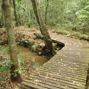
From the end of Evans Rd, Toukley, the walk passes around a gate, passes an information board and ‘Wyrrabalong National Park’ sign, and follows the bush track. The track winds through the swampy forest for a while, crossing a small wooden bridge, before passing a ‘Wetlands’ information board, on the right. The track then meanders through the forest for some time, passing a ‘Wetlands Trail’ sign, to the right. The forest becomes drier and the track becomes wider and sandy as it undulates through the forest to reach the intersection with the ‘Red Gum Track’.
Continue straight: From the intersection, the walk follows the right arrow on the ‘Red Gum Trail’ sign, along the sandy bush track. The track immediately drops through a gully and meanders up the other side. This section of the walk climbs and drops a little as it passes through very nice forest, with twisted tree branches leaning over the trail. The track passes a ‘Red Gum Forest’ information board, to the left, and continues for while to reach a wooden lookout platform with atmospheric views to the north and north-east.
Continue straight: From the intersection, the walk follows the right arrow on the ‘Red Gum Trail’ sign, along the sandy bush track. The track immediately drops through a gully and meanders up the other side. This section of the walk climbs and drops a little as it passes through very nice forest, with twisted tree branches leaning over the trail. The track passes a ‘Red Gum Forest’ information board, to the left, and continues for while to reach a wooden lookout platform with atmospheric views to the north and north-east.
Redgum lookout
This unnamed lookout is in the Wyrrabalong National park, north of The Entrance and provides views to the north across part of Tuggerah Lake and Toukley. The lookout is on the Redgum Trail and consists of a fenced wooden platform with a seat. This is a nice, atmospheric spot to take a break on the walk.
(1.56km) Redgum lookout → Tuggerah lake lookout
710 m
11 mins
4m
-4m
Moderate track
Turn left: From the lookout, the walk follows the sandy bush track to the west, leaving the lookout platform behind and to the right. The sandy track undulates through nice forest and bends to the left (south) and continues for some distance, offering glimpses of Tuggerah lake, to the right, and the ocean, to the left. The track then reaches another wooden lookout platform, a little to the right of the track, with great views to the west, over Tuggerah lake.
Tuggerah Lake lookout
This unnamed lookout provides views across Tuggerah Lake, north of The Entrance. The lookout is on the Redgum Trail and consists of a fenced wooden platform with a seat. the beautiful views and atmosphere make this a great spot for a break during a walk in the area.
(2.27km) Tuggerah lake lookout → Tuggerah lake vista
1.6 km
28 mins
17m
-46m
Moderate track
Continue straight: From the lookout, the walk follows the sandy bush track to the south, leaving the lookout platform behind and to the right. This section of the walk also undulates through nice forest on a sandy track. The walk then reaches the intersection with ‘The Lilly Pilly Loop Trail’.
Veer right: From the intersection, the walk follows the right arrow on the ‘Lilly Pilly Loop Trail’ sign, along the sandy bush track, going up the hill. The track undulates through nice forest for some distance, with sections of erosion control board walkway, and timber retaining walls. From here, the track offers great views of the lake, and passes through increasingly moist forest, before dropping a little and running along the edge of Tuggerah lake. After running along the lake edge for a while, the walk reaches a lakeside vista where the track bends sharply to the left (heading away from the lake, into a thick, shaded section of forest).
Veer right: From the intersection, the walk follows the right arrow on the ‘Lilly Pilly Loop Trail’ sign, along the sandy bush track, going up the hill. The track undulates through nice forest for some distance, with sections of erosion control board walkway, and timber retaining walls. From here, the track offers great views of the lake, and passes through increasingly moist forest, before dropping a little and running along the edge of Tuggerah lake. After running along the lake edge for a while, the walk reaches a lakeside vista where the track bends sharply to the left (heading away from the lake, into a thick, shaded section of forest).
Tuggerah Lake vista
This informal, unnamed spot at the edge of Tuggerah Lake, north of The Entrance, has beautiful views across the lake. These views, combined with the nearby area of rainforest, provide beautiful scenery on walks in the area.
Lilly Pilly loop rainforest
This area of littoral rainforest is on the Lilly Pilly loop walk, in Wyrrabalong National Park, north of The Entrance. This small remnant of rainforest is dominated by cabbage palms, corkwoods and tuckeroos. There are nice views across Tuggerah lake from the edge of the forest as well.
(3.87km) Tuggerah lake vista → Int of Lilly Pilly loop and Sth Lilly Pilly access trail
820 m
14 mins
19m
-3m
Moderate track
Veer left: From the lakeside vista, the walk follows the bush track, going into the thick, shaded forest, away from Tuggerah lake. This beautiful section of the walk passes through an area of littoral rainforest. The walk passes a ‘Rainforests’ information board, to the right and continues through the forest. As the walk climbs a little, the forest becomes drier. The walk continues along a ridge line for a short distance to reach the intersection signposted ‘Lilly Pilly Loop Link Trail’.
(4.69km) Int of Lilly Pilly loop and Sth Lilly Pilly access trail → South car park
80 m
2 mins
0m
-6m
Moderate track
Continue straight: From the intersection, the walk follows the level, sandy management trail towards the nearby road (opposite direction to the signpost arrow). After a short distance, the trail bends to the right and goes down hill a little. The walk passes an information board and ‘Lilly Pilly Loop Trail’ sign before going around a gate and arriving at the car park on the Central Coast Hwy, aka Wilfred Barret Dr (about 5.5 km north of The Entrance bridge, and about 4.6km south of the intersection with Main Rd, Noraville. Signposted ‘Wyrrabalong National Park’).
Maps for the Wetland trail to Rainforest walk
You can download the PDF for this walk to print a map.
These maps below cover the walk and the wider area around the walk, they are worth carrying for safety reasons.
| Toukley | 1:25 000 Map Series | 92313N TOUKLEY | NSW-92313N |
| Lake Macquarie | 1:100 000 Map Series | 9231 LAKE MACQUARIE | 9231 |
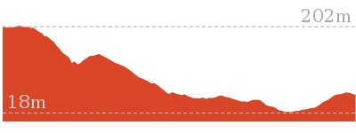
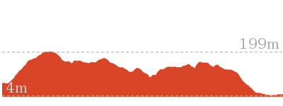
Cross sectional view of the Wetland trail to Rainforest bushwalking track
Analysis and summary of the altitude variation on the Wetland trail to Rainforest
Overview of this walks grade – based on the AS 2156.1 – 2001
Under this standard, a walk is graded based on the most difficult section of the walk.
| Length | 4.8 km | ||
| Time | 1 hr 45 mins | ||
| . | |||
| Grade 3/6 Moderate track |
AS 2156.1 | Gradient | Short steep hills (3/6) |
| Quality of track | Clear and well formed track or trail (2/6) | ||
| Signs | Directional signs along the way (3/6) | ||
| Experience Required | Some bushwalking experience recommended (3/6) | ||
| Weather | Weather generally has little impact on safety (1/6) | ||
| Infrastructure | Limited facilities, not all cliffs are fenced (3/6) |
Some more details of this walks Grading
Here is a bit more details explaining grading looking at sections of the walk
Gradient
Around 3.8km of this walk has short steep hills, whilst the remaining 930m has gentle hills with occasional steps.
Quality of track
This whole walk, 4.8km follows a clear and well formed track or trail.
Signs
Around 4.1km of this walk has directional signs at most intersection, whilst the remaining 710m is clearly signposted.
Experience Required
Around 2.8km of this walk requires no previous bushwalking experience, whilst the remaining 2km requires some bushwalking experience.
weather
This whole walk, 4.8km is not usually affected by severe weather events (that would unexpectedly impact safety and navigation).
Infrastructure
Around 3km of this walk has limited facilities (such as not all cliffs fenced), whilst the remaining 1.8km is close to useful facilities (such as fenced cliffs and seats).
Similar walks
A list of walks that share part of the track with the Wetland trail to Rainforest walk.
1.8 km Return
45 mins
Moderate track
3.1 km Return
1 hr 15 mins
Moderate track
3.4 km Circuit
1 hr 15 mins
Moderate track
3.6 km Circuit
1 hr 15 mins
Moderate track
6.9 km Circuit
2 hrs 15 mins
Moderate track
Other Nearby walks
A list of walks that start near the Wetland trail to Rainforest walk.
2.5 km Circuit
1 Hr
Hard track
2.2 km Return
1 Hr
Moderate track
1.6 km Return
45 mins
Hard track
762 m Return
30 mins
Very easy
150 m Return
15 mins
Easy track
2.6 km Return
1 Hr
Hard track
444 m Return
10 mins
Easy track
136 m Return
3 mins
Very easy
1.2 km Return
25 mins
Easy track
3.3 km Return
1 hr 15 mins
Moderate track

4.2 km One way
1 hr 45 mins
Experienced only
2.4 km One way
1 Hr
Moderate track
Plan your trip to and from the walk here
The Wetland trail to Rainforest walk starts at the End of Evans Rd (gps: -33.282853, 151.55077)
Your transport options to End of Evans Rd are by;
![]() Bus. A bus service runs from Lake Haven to Evans Rd. The service only runs a few times a day. Please check timetable for more info or Phone Busway on (02) 4392 6666 (route 91) (get details)
Bus. A bus service runs from Lake Haven to Evans Rd. The service only runs a few times a day. Please check timetable for more info or Phone Busway on (02) 4392 6666 (route 91) (get details)
![]() Car. There is free parking available.
Car. There is free parking available.
(get details)
The Wetland trail to Rainforest ends at the South car park (gps: -33.300644, 151.53294)
Your main transport option to South car park is by;
![]() Car. There is free parking available.
Car. There is free parking available.
(get details)
Short URL = http://wild.tl/wttr
Gallery images
There are other downloads I am still working on.
You will probably need to login to access these — still all free.
* KML (google earth file)
* GPX (GPS file)
Special Maps/ brochures
* A3 topo maps
* PDF with Lands Topo map base
* PDF with arial image (and map overlay)
I wanted to get the main site live first, this extra stuff will come in time.
Happy walking
Matt 🙂
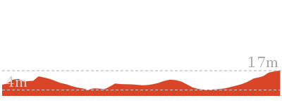
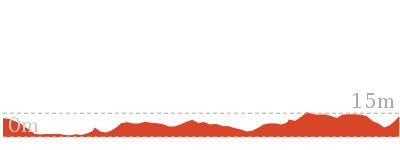
Forresters Beach to Crackneck Beach
And Walk
Forresters Beach to Crackneck Beach

2 hrs 30 mins
5.8 km Return
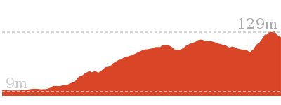
254 m
Experienced only
A great walk along the boulder strewn shoreline to the unnamed beach below Crackneck Lookout. Much of this walk is very exposed to the ocean and should not be attempted at high tide or during rough seas. Plenty of rock hopping over the boulders makes the walking harder but also makes the scenery more interesting. The shapes and textures in the rock, combined with the imposing hills and low cliffs of the coastline give quite dramatic scenery and atmosphere for the walk. * This walk passes through very remote areas and sections have no visible track. At least one person in your group should have training and experience in off track walking and navigation. Even with these notes and a GPS these extra skills and equipment are required.

(0km) Int of South Scenic Rd and Henrys Rd → Bottom of Henrys Rd beach access
80 m
2 mins
0m
-18m
Moderate track
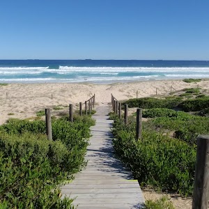
From the top of the beach access track, this walk goes over the low gate and follows the management trail steeply down the hill. The walk passes a shower area, to the right, and continues a short distance down the boarded trail to Forresters Beach.
Forresters Beach
Forresters Beach is the name of a township and beach on the Central Coast of NSW. There are public toilets and a beach access path near the intersection of Crystal St and Kalakau Ave, and a beach access path near the bottom of Henrys Rd.
(0.08km) Bottom of Henrys Rd beach access → Northern end of Forresters Beach
800 m
15 mins
16m
-21m
Hard track
Turn left: From the bottom of the Henrys Rd beach access trail, this walk goes north along the beach, keeping the ocean to the right. After a while, the walk reaches the end of the sandy beach where the rocky shoreline starts.
(0.88km) Northern end of Forresters Beach → Crackneck beach
2 km
45 mins
104m
-95m
Experienced only
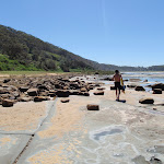
Continue straight: From the northern end of Forresters Beach, this walk follows the coast north, keeping the ocean to the right. The walk travels over the rocky, boulder-covered shoreline for quite a while, with a lot of rock-hopping involved. There is only a narrow strip between the water and the steep hills, to the left, and great care should be exercised. The imposing hills, interesting textures and shapes in the rocks, and the crashing waves all combine to provide fantastic scenery and atmosphere. A fair number of old engine blocks and other car parts are lying in the rocks, rusting away slowly. The walk eventually reaches the unnamed beach beneath Crackneck Lookout, covered in rounded fist-sized rocks. Note: This section of the walk may be impassible at high tide or during high seas.
Crackneck Beach
This unnamed beach is below Crackneck Lookout and can be reached with some difficulty by walking along the very rocky shoreline from Forresters Beach, to the south, or from Bateau Bay beach, to the north. The beach is covered in rounded rocks about the size of a fist.
Maps for the Forresters Beach to Crackneck Beach walk
You can download the PDF for this walk to print a map.
These maps below cover the walk and the wider area around the walk, they are worth carrying for safety reasons.
| Gosford | 1:25 000 Map Series | 91312S GOSFORD | NSW-91312S |
| Gosford | 1:100 000 Map Series | 9131 GOSFORD | 9131 |
Cross sectional view of the Forresters Beach to Crackneck Beach bushwalking track
Analysis and summary of the altitude variation on the Forresters Beach to Crackneck Beach
Overview of this walks grade – based on the AS 2156.1 – 2001
Under this standard, a walk is graded based on the most difficult section of the walk.
| Length | 5.8 km | ||
| Time | 2 hrs 30 mins | ||
| . | |||
| Grade 5/6 Experienced only |
AS 2156.1 | Gradient | Short steep hills (3/6) |
| Quality of track | Rough unclear track (5/6) | ||
| Signs | Minimal directional signs (4/6) | ||
| Experience Required | Moderate level of bushwalking experience recommended (4/6) | ||
| Weather | Forecast, unforecast storms and severe weather may impact on navigation and safety (4/6) | ||
| Infrastructure | No facilities provided (5/6) |
Some more details of this walks Grading
Here is a bit more details explaining grading looking at sections of the walk
Gradient
Around 2.1km of this walk has short steep hills, whilst the remaining 800m is flat with no steps.
Quality of track
2km of this walk follows a rough unclear track and another 800m follows a rough track, where fallen trees and other obstacles are likely. The remaining (80m) follows a clear and well formed track or trail.
Signs
Around 2.8km of this walk has minimal directional signs, whilst the remaining 80m has directional signs at most intersection.
Experience Required
Around 2km of this walk requires a leader a with moderate level of bushwalking experience, whilst the remaining 880m requires some bushwalking experience.
weather
Around 2km of this walk is affected by forecast, unforecast storms and severe weather events that may impact on navigation and safety, whilst the remaining 880m is not usually affected by severe weather events (that would unexpectedly impact safety and navigation).
Infrastructure
2km of this walk has no facilities provided and another 800m has limited facilities (such as not all cliffs fenced). The remaining (80m) is close to useful facilities (such as fenced cliffs and seats).
Similar walks
A list of walks that share part of the track with the Forresters Beach to Crackneck Beach walk.
4.6 km One way
2 hrs
Experienced only
9.1 km Circuit
3 hrs 30 mins
Experienced only
Other Nearby walks
A list of walks that start near the Forresters Beach to Crackneck Beach walk.
382 m Return
15 mins
Moderate track
1.6 km One way
45 mins
Moderate track
646 m One way
15 mins
Moderate track
1.7 km One way
1 hr 30 mins
Moderate track
892 m Circuit
30 mins
Hard track
3.4 km Return
1 hr 15 mins
Experienced only
2 km Return
1 Hr
Moderate track
890 m Return
30 mins
Easy track
1.6 km Circuit
45 mins
Easy track
5.3 km Circuit
2 hrs 45 mins
Moderate track
8.5 km One way
3 hrs 45 mins
Hard track
1.2 km Circuit
45 mins
Moderate track
Plan your trip to and from the walk here
The Forresters Beach to Crackneck Beach walk starts and ends at the Int of South Scenic Rd and Henrys Rd (gps: -33.41096, 151.46547)
Your transport options to Int of South Scenic Rd and Henrys Rd are by;
![]() Bus. (get details)
Bus. (get details)
![]() Car. There is free parking available.
Car. There is free parking available.
(get details)
Short URL = http://wild.tl/fbtcb
Gallery images
There are other downloads I am still working on.
You will probably need to login to access these — still all free.
* KML (google earth file)
* GPX (GPS file)
Special Maps/ brochures
* A3 topo maps
* PDF with Lands Topo map base
* PDF with arial image (and map overlay)
I wanted to get the main site live first, this extra stuff will come in time.
Happy walking
Matt 🙂
Wyrrabalong Figure 8
And Walk
Wyrrabalong Figure 8

2 hrs 15 mins
6.9 km Circuit
104 m
Moderate track
A great walk covering much of the excellent scenery in this area. This walk includes great views over Tuggerah lake, some beautiful areas of littoral rainforest, very picturesque, twisted Sydney Redgums leaning over the track and plenty of Burrawangs (a cycad). The lookouts along the way provide good spots to relax for a while. Much of the walking is on sandy tracks, which will slow you down a little.


(0km) Burrawang car park → Int of Burrawang track and Redgum trail
60 m
1 mins
0m
-1m
Easy track
From the car park on the Central Coast Hwy, aka Wilfred Barret Dr (about 7km north of The Entrance bridge, and about 3km south of the intersection with Main Rd, Noraville. Signposted ‘Wyrrabalong National Park’), the walk passes through the timber fence, passing an information board, to the left, and a picnic table, to the right, and follows the sandy management trail. After a very short distance, the trail arrives at the intersection of the ‘Red Gum Trail’ and the ‘Burrawang Walking Track’.
(0.06km) Int of Burrawang track and Redgum trail → Redgum lookout
1.1 km
19 mins
28m
-6m
Moderate track
Turn right: From the intersection, the walk follows the ‘Red Gum Trail’ arrow along the wide, level, sandy track. The track climbs a little through a series of bends, passing a couple of ‘Red Gum Trail’ signs. There are some very nice sections of forest along here, with twisted trees leaning over the track. The track continues for some time before arriving at the intersection with the ‘Wetland Trail’.
Turn left: From the intersection, the walk follows the right arrow on the ‘Red Gum Trail’ sign, along the sandy bush track. The track immediately drops through a gully and meanders up the other side. This section of the walk climbs and drops a little as it passes through very nice forest, with twisted tree branches leaning over the trail. The track passes a ‘Red Gum Forest’ information board, to the left, and continues for while to reach a wooden lookout platform with atmospheric views to the north and north-east.
Turn left: From the intersection, the walk follows the right arrow on the ‘Red Gum Trail’ sign, along the sandy bush track. The track immediately drops through a gully and meanders up the other side. This section of the walk climbs and drops a little as it passes through very nice forest, with twisted tree branches leaning over the trail. The track passes a ‘Red Gum Forest’ information board, to the left, and continues for while to reach a wooden lookout platform with atmospheric views to the north and north-east.
Redgum lookout
This unnamed lookout is in the Wyrrabalong National park, north of The Entrance and provides views to the north across part of Tuggerah Lake and Toukley. The lookout is on the Redgum Trail and consists of a fenced wooden platform with a seat. This is a nice, atmospheric spot to take a break on the walk.
(1.14km) Redgum lookout → Tuggerah lake lookout
710 m
11 mins
4m
-4m
Moderate track
Turn left: From the lookout, the walk follows the sandy bush track to the west, leaving the lookout platform behind and to the right. The sandy track undulates through nice forest and bends to the left (south) and continues for some distance, offering glimpses of Tuggerah lake, to the right, and the ocean, to the left. The track then reaches another wooden lookout platform, a little to the right of the track, with great views to the west, over Tuggerah lake.
Tuggerah Lake lookout
This unnamed lookout provides views across Tuggerah Lake, north of The Entrance. The lookout is on the Redgum Trail and consists of a fenced wooden platform with a seat. the beautiful views and atmosphere make this a great spot for a break during a walk in the area.
(1.85km) Tuggerah lake lookout → Tuggerah lake vista
2.7 km
46 mins
17m
-45m
Moderate track
Continue straight: From the lookout, the walk follows the sandy bush track to the south, leaving the lookout platform behind and to the right. This section of the walk also undulates through nice forest on a sandy track. The walk then reaches the intersection with ‘The Lilly Pilly Loop Trail’.
Veer left: From the intersection, the walk follows the left arrow on the ‘Lilly Pilly Loop Trail’ sign, along the sandy bush track. The track immediately drops through a gully, then winds through some nice forest for a short distance before arriving at the intersection with the ‘Burrawang Walking Track’.
Veer right: From the intersection, the walk follows the sandy bush track up the hill, leaving the ‘Lilly Pilly Loop Trail’ sign on the right. After a while the track descends, with sections of erosion control board walkway, through nice forest, before reaching the intersection signposted with ‘Lilly Pilly Loop Link Trail’.
Turn right: From the intersection, the walk follows the ‘Lilly Pilly Loop Link Trail’ arrow, along the narrow bush track, going up the hill. This section of track meanders through an interesting mixture of patches of littoral rainforest and some drier forest. One very sandy section of the track is held in place by low, timber retaining walls. The walk continues, eventually climbing a little through thick, vine covered vegetation, to reach an intersection marked with a ‘Lilly Pilly Loop Link Trail’ sign.
Turn right: From the intersection, the walk follows the sandy bush track, going up the hill, away from the nearby road. The track runs along a ridge line, through relatively dry forest for a while, before dropping a little, into moist littoral rainforest. The walk meanders through this beautiful area of rainforest, passing a ‘Rainforests’ information board, to the left, and then emerges to a nice vista at the edge of Tuggerah lake.
Lilly Pilly loop rainforest
This area of littoral rainforest is on the Lilly Pilly loop walk, in Wyrrabalong National Park, north of The Entrance. This small remnant of rainforest is dominated by cabbage palms, corkwoods and tuckeroos. There are nice views across Tuggerah lake from the edge of the forest as well.
Tuggerah Lake vista
This informal, unnamed spot at the edge of Tuggerah Lake, north of The Entrance, has beautiful views across the lake. These views, combined with the nearby area of rainforest, provide beautiful scenery on walks in the area.
(4.51km) Tuggerah lake vista → Int of Burrawang track and Redgum trail
2.3 km
41 mins
54m
-47m
Moderate track
Veer right: From the lakeside vista, the walk follows the bush track north, keeping Tuggerah lake to the left. The track follows the lake edge for a short distance before climbing away to the right. This section of the track undulates through quite moist forest, with some great views back across the lake, then passes some timber retaining walls. From here, the walk undulates through drier forest for some distance, with sections of erosion control board walkway, to reach the intersection with the ‘Red Gum Trail’.
Turn right: From the intersection, the walk follows the left arrow on the ‘Lilly Pilly Loop Trail’ sign, along the sandy bush track. The track immediately drops through a gully, then winds through some nice forest for a short distance before arriving at the intersection with the ‘Burrawang Walking Track’.
Turn left: From the intersection, the walk follows the ‘Burrawang Walking Track’ sign, steeply down the hill and along the sandy bush track. After descending for a short distance, the track levels out before meandering through some nice forest. The thick vegetation is very closed in at times. The track passes a ‘Burrawang Walking Track’ signpost, to the left, and continues to wind through the nice forest to reach the signposted intersection with the ‘Red Gum Trail’.
(6.82km) Int of Burrawang track and Redgum trail → Burrawang car park
60 m
1 mins
1m
0m
Easy track
Continue straight: From the intersection, the walk follows the sandy management trail up the hill, towards the road. After a very short distance the walk climbs some wooden steps, passes a picnic table, to the left, an information board, to the right, and passes through a timber fence to reach the car park on the Central Coast Hwy, aka Wilfred Barret Dr (about 7km north of The Entrance bridge, and about 3km south of the intersection with Main Rd, Noraville. Signposted ‘Wyrrabalong National Park’).
Maps for the Wyrrabalong Figure 8 walk
You can download the PDF for this walk to print a map.
These maps below cover the walk and the wider area around the walk, they are worth carrying for safety reasons.
| Toukley | 1:25 000 Map Series | 92313N TOUKLEY | NSW-92313N |
| Lake Macquarie | 1:100 000 Map Series | 9231 LAKE MACQUARIE | 9231 |
Cross sectional view of the Wyrrabalong Figure 8 bushwalking track
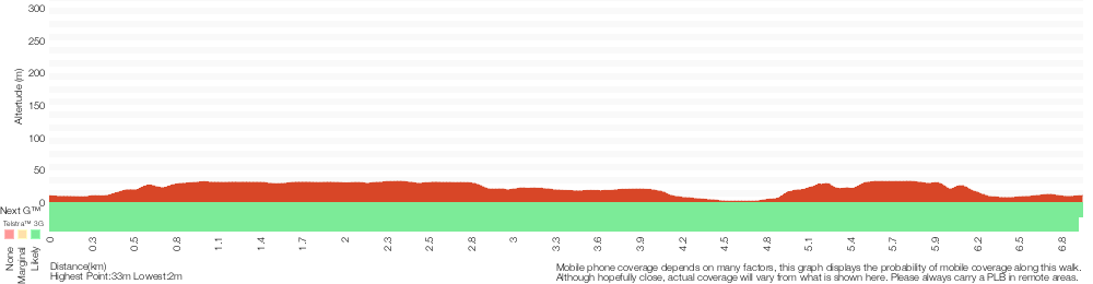
Analysis and summary of the altitude variation on the Wyrrabalong Figure 8
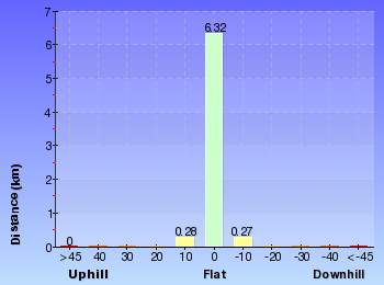
Overview of this walks grade – based on the AS 2156.1 – 2001
Under this standard, a walk is graded based on the most difficult section of the walk.
| Length | 6.9 km | ||
| Time | 2 hrs 15 mins | ||
| . | |||
| Grade 3/6 Moderate track |
AS 2156.1 | Gradient | Short steep hills (3/6) |
| Quality of track | Formed track, with some branches and other obstacles (3/6) | ||
| Signs | Directional signs along the way (3/6) | ||
| Experience Required | Some bushwalking experience recommended (3/6) | ||
| Weather | Weather generally has little impact on safety (1/6) | ||
| Infrastructure | Limited facilities, not all cliffs are fenced (3/6) |
Some more details of this walks Grading
Here is a bit more details explaining grading looking at sections of the walk
Gradient
Around 4.2km of this walk has short steep hills, whilst the remaining 2.7km has gentle hills with occasional steps.
Quality of track
Around 4.8km of this walk follows a clear and well formed track or trail, whilst the remaining 2.1km follows a formed track, with some branches and other obstacles.
Signs
Around 6km of this walk has directional signs at most intersection, whilst the remaining 740m is clearly signposted.
Experience Required
Around 4.4km of this walk requires no previous bushwalking experience, whilst the remaining 2.4km requires some bushwalking experience.
weather
This whole walk, 7km is not usually affected by severe weather events (that would unexpectedly impact safety and navigation).
Infrastructure
Around 5km of this walk has limited facilities (such as not all cliffs fenced), whilst the remaining 1.9km is close to useful facilities (such as fenced cliffs and seats).
Similar walks
A list of walks that share part of the track with the Wyrrabalong Figure 8 walk.
1.8 km Return
45 mins
Moderate track
3.1 km Return
1 hr 15 mins
Moderate track
3.4 km Circuit
1 hr 15 mins
Moderate track
3.6 km Circuit
1 hr 15 mins
Moderate track
4.8 km One way
1 hr 45 mins
Moderate track
Other Nearby walks
A list of walks that start near the Wyrrabalong Figure 8 walk.
2.5 km Circuit
1 Hr
Hard track
2.2 km Return
1 Hr
Moderate track
1.6 km Return
45 mins
Hard track
762 m Return
30 mins
Very easy
150 m Return
15 mins
Easy track
2.6 km Return
1 Hr
Hard track
3.8 km One way
1 hr 30 mins
Moderate track
444 m Return
10 mins
Easy track
136 m Return
3 mins
Very easy
892 m Circuit
30 mins
Hard track
3.4 km Return
1 hr 15 mins
Experienced only
4.6 km One way
2 hrs
Experienced only
Plan your trip to and from the walk here
The Wyrrabalong Figure 8 walk starts and ends at the Burrawang car park (gps: -33.293676, 151.54662)
Your main transport option to Burrawang car park is by;
![]() Car. There is free parking available.
Car. There is free parking available.
(get details)
Short URL = http://wild.tl/wf8
Gallery images
There are other downloads I am still working on.
You will probably need to login to access these — still all free.
* KML (google earth file)
* GPX (GPS file)
Special Maps/ brochures
* A3 topo maps
* PDF with Lands Topo map base
* PDF with arial image (and map overlay)
I wanted to get the main site live first, this extra stuff will come in time.
Happy walking
Matt 🙂
Wyrrabalong Coast Walk circuit
And Walk
Wyrrabalong Coast Walk circuit

3 hrs 30 mins
9.1 km Circuit
348 m
Experienced only
A fairly tough but fantastic walk in the southern section of Wyrrabalong National Park. This walk runs through a long, thin strip of beautiful coastal forest, with fantastic views of the coastline from many vantage points along the way, and returns via the boulder-strewn shoreline and beaches. There is a lot of rock-hopping along the shoreline section and it is very exposed to the ocean, so it is fairly tough going and should not be attempted at high tide or with heavy seas. The variety of scenery through the various stages of the walk is excellent.* This walk passes through very remote areas and sections have no visible track. At least one person in your group should have training and experience in off track walking and navigation. Even with these notes and a GPS these extra skills and equipment are required.
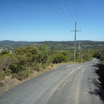
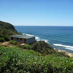
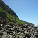
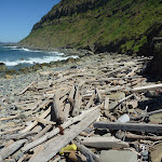

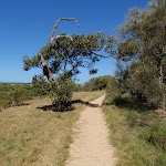
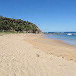
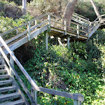
Bateau Bay Beach picnic area and lookout
This unnamed picnic area and lookout is within Wyrrabalong National Park, at the intersection of Reserve Dr and Harbour St, Bateau Bay. The picnic area overlooks Bateau Bay and the beach. There are large grass areas, plenty of shade and facilities including picnic tables, garbage bins, and beach access steps. There are beautiful views along the coast and out to sea from the picnic area. There are free electric BBQs at Sutton Reserve, a block further south along Reserve Dr. Takeaway food is available at a small shopping centre near the intersection of Harbour St and Bateau Bay Rd, one block from the picnic area.
(0km) Top of northern Bateau Bay Beach access steps → South end of Bateau Bay Beach picnic area
100 m
2 mins
1m
-1m
Moderate track
Starting from the track intersection beside the beach access steps, this walk follows the faint track a very short distance across the picnic area, keeping Reserve Dr to the right. The walk soon arrives at some seats and an open viewing area, to the left, with stunning views across the water.
Continue straight: From the viewpoint, this walk goes south across the picnic area, keeping Reserve Dr to the right. The walk passes a fenced viewing area just before reaching an intersection at the end of the picnic area, with a concrete beach-access track to the left.
Continue straight: From the viewpoint, this walk goes south across the picnic area, keeping Reserve Dr to the right. The walk passes a fenced viewing area just before reaching an intersection at the end of the picnic area, with a concrete beach-access track to the left.
(0.1km) South end of Bateau Bay Beach picnic area → Rushby St car park
260 m
5 mins
10m
-1m
Moderate track
Continue straight: From the intersection, this walk follows the bush track past the ‘Wyrrabalong National Park Service Trail Walkers Only’ sign, keeping Reserve Dr to the right. This walk passes through a nice strip of forest, passing a number of fenced viewing points, to the left, with great views out to sea. After a while, the walk emerges at another picnic area, next to a toilet block, and continues across the picnic area and car park, reaching an intersection signposted ‘Coast Track’, with a gated concrete driveway and beach access steps to the left.
Southern Bateau Bay beach picnic area
This picnic area, near the intersection of Reserve Dr and Rushby St, Bateau Bay, overlooks the southern end of Bateau Bay and the beach. The facilities include toilets, picnic tables, garbage bins and some slides for the kids. There are great views along the coast and out to sea. There is plenty of shade.
(0.36km) Rushby St car park → Crackneck Lookout
1.3 km
29 mins
88m
-12m
Moderate track
Continue straight: From the intersection, the walk follows the ‘Coast Track’ arrow along the bush track, keeping Reserve Dr to the right. The walk climbs gently and passes a number of side tracks on either side, which go a short distance to ocean viewing spots or the nearby road. After a while, the walk reaches an intersection in the middle of a grassy clearing, with more ocean views.
Continue straight: From the intersection, the walk follows the bush track south, keeping Reserve Dr to the right. The walk soon passes a bench seat with a commemorative plaque, and continues through the bush on the sandy track. Ignoring a track to the right (which goes to the nearby street), the walk continues along sections of track with retaining boards, for some time before arriving beside Hilltop St. The walk continues along the bush track close to Hilltop St, going along sections of boardwalk before climbing some wooden steps and emerging at the northern edge of Crackneck Lookout (at the end of Hilltop St).
Continue straight: From the intersection, the walk follows the bush track south, keeping Reserve Dr to the right. The walk soon passes a bench seat with a commemorative plaque, and continues through the bush on the sandy track. Ignoring a track to the right (which goes to the nearby street), the walk continues along sections of track with retaining boards, for some time before arriving beside Hilltop St. The walk continues along the bush track close to Hilltop St, going along sections of boardwalk before climbing some wooden steps and emerging at the northern edge of Crackneck Lookout (at the end of Hilltop St).
Crackneck Lookout
This lookout, at the end of Hilltop St, Bateau Bay, has stunning views up and down the coastline, and out to sea. There are picnic tables and an information board about marine mammals. There is a hangliding launch spot beside the lookout.
(1.65km) Crackneck Lookout → Int of Coast Track and southern Stephenson Rd access track
510 m
11 mins
25m
-11m
Moderate track
Veer right: From the southern edge of Crackneck Lookout (at the end of Hilltop St), the walk goes around the gate and follows the ‘Coast Track’ arrow, along the old management trail toward ‘Wyrrabalong Lookout’, keeping the ocean to the left. The walk passes a National Park information board, to the left, then takes the right-hand branch at a prominent fork. From here, the walk follows the main trail, ignoring numerous short side tracks (some of which lead to clifftop viewpoints) until reaching the end of the management trail and the start of a sandy bush track, to the right, marked with some timber posts.
Veer right: From the junction at the end of the management trail, this walk follows the sandy bush track marked with some timber posts. The track goes for a very short distance to an intersection, with another sandy bush track to the right, marked with several wooden posts and a signpost (indicating walkers are permitted but no dogs or motorbikes).
Continue straight: From the intersection, this walk follows the sandy bush track south, leaving the signpost behind on the right. The track passes through lovely bush with plenty of grass trees and, after a short distance, reaches an intersection with another sandy bush track, to the right, at the start of some low sandstone retaining walls.
(2.17km) Int of Coast Track and southern Stephenson Rd access track → End of Stephenson Rd
130 m
2 mins
1m
-6m
Moderate track
Turn right: From the intersection, this walk follows the sandy bush track away from the ocean, towards the large water tanks. The track widens to a management trail and passes the tanks, to the right, and continues down the hill, passing around a gate, to the end of Stephenson Rd, Bateau Bay.
(2.17km) Int of Coast Track and southern Stephenson Rd access track → Wyrrabalong Lookout
920 m
20 mins
43m
-32m
Moderate track
Veer left: From the intersection, the walk follows the sandy bush track south, keeping the ocean to the left. Initially the track has low sandstone retaining walls on either side. The track soon passes a ‘Coastal Heathlands’ information board and continues along the top of a ridge with extensive views out to sea, and inland, before going down a long set of metal stairs. The walk then passes through a section of thick heath, before emerging briefly to more ocean views at a fenced viewpoint. The track continues for some distance, with occasional ocean views, climbing several sets of wooden steps before arriving at the Wyrrabalong Lookout.
Wyrrabalong Lookout and Cromarty Hill
This lookout and picnic area is on Cromarty Hill, near the end of Cromarty Hill Rd, Forresters Beach. There are picnic tables and fantastic views from the lookout point, as well as the concrete roof platform beside the large communications tower. There is a hang gliding launch spot beside the lookout.
(3.09km) Wyrrabalong Lookout → Int of South Scenic Rd and Henrys Rd
1.4 km
26 mins
11m
-108m
Moderate track
Veer right: From Wyrrabalong Lookout, this walk goes across the grassy area, passing a trig point (to the left) and following the old management trail between the communications tower and satellite dish. There are great views over Forresters Beach from the concrete platform on top of the building, next to the tower. The walk then goes down the hill for a short distance, passing around a gate, signposted ‘Wyrrabalong National Park’, and arriving at the end of Cromarty Hill Rd.
Continue straight: From the end of Cromarty Hill Rd, this walk follows the road down the hill, away from the ‘Wyrrabalong National Park’ sign. After a while, the road changes from gravel to asphalt, bends to the left and becomes North Scenic Rd. The walk continues along the road until reaching the intersection with Forresters Beach Rd.
Turn left: From the intersection, this walk follows Forresters Beach Rd down the hill. The road soon bends to the right and becomes South Scenic Rd as it runs parallel to the beach. After a short distance, the walk reaches the top of the beach access track near the intersection with Henrys Rd.
(4.45km) Int of South Scenic Rd and Henrys Rd → Bottom of Henrys Rd beach access
80 m
2 mins
0m
-18m
Moderate track
Turn left: From the top of the beach access track, this walk goes over the low gate and follows the management trail steeply down the hill. The walk passes a shower area, to the right, and continues a short distance down the boarded trail to Forresters Beach.
Forresters Beach
Forresters Beach is the name of a township and beach on the Central Coast of NSW. There are public toilets and a beach access path near the intersection of Crystal St and Kalakau Ave, and a beach access path near the bottom of Henrys Rd.
(4.53km) Bottom of Henrys Rd beach access → Crackneck beach
2.8 km
1 Hr
120m
-116m
Experienced only
Turn left: From the bottom of the Henrys Rd beach access trail, this walk goes north along the beach, keeping the ocean to the right. After a while, the walk reaches the end of the sandy beach where the rocky shoreline starts.
Continue straight: From the northern end of Forresters Beach, this walk follows the coast north, keeping the ocean to the right. The walk travels over the rocky, boulder-covered shoreline for quite a while, with a lot of rock-hopping involved. There is only a narrow strip between the water and the steep hills, to the left, and great care should be exercised. The imposing hills, interesting textures and shapes in the rocks, and the crashing waves all combine to provide fantastic scenery and atmosphere. A fair number of old engine blocks and other car parts are lying in the rocks, rusting away slowly. The walk eventually reaches the unnamed beach beneath Crackneck Lookout, covered in rounded fist-sized rocks. Note: This section of the walk may be impassible at high tide or during high seas.
Continue straight: From the northern end of Forresters Beach, this walk follows the coast north, keeping the ocean to the right. The walk travels over the rocky, boulder-covered shoreline for quite a while, with a lot of rock-hopping involved. There is only a narrow strip between the water and the steep hills, to the left, and great care should be exercised. The imposing hills, interesting textures and shapes in the rocks, and the crashing waves all combine to provide fantastic scenery and atmosphere. A fair number of old engine blocks and other car parts are lying in the rocks, rusting away slowly. The walk eventually reaches the unnamed beach beneath Crackneck Lookout, covered in rounded fist-sized rocks. Note: This section of the walk may be impassible at high tide or during high seas.
Crackneck Beach
This unnamed beach is below Crackneck Lookout and can be reached with some difficulty by walking along the very rocky shoreline from Forresters Beach, to the south, or from Bateau Bay beach, to the north. The beach is covered in rounded rocks about the size of a fist.
(7.35km) Crackneck beach → Crackneck rockshelf
470 m
9 mins
15m
-18m
Experienced only
Continue straight: From the unnamed beach beneath Crackneck Lookout, this walk follows the coastline north, keeping the ocean to the right. The walk goes around the headland and continues across the rockshelf to the end of a sandy track running behind the rockshelf. There are some interesting textures in the rock, with some regular, angular cracks in places, making for some intriguing scenery.
(7.81km) Crackneck rockshelf → Southern end of Bateau Bay Beach
710 m
13 mins
17m
-18m
Experienced only
Continue straight: From the rockshelf, this walk follows the sandy track north, keeping the ocean to the right. The track runs along a narrow strip of level ground beneath the hills as it approaches Bateau Bay. After a short distance, the walk passes some mangrove trees, to the right, reaching the start of a narrow strip of beach.
Continue straight: From the end of the narrow beach strip, this walk goes north along the sand, keeping the ocean to the right. The walk passes a concrete stormwater outlet (to the left) and a short distance later reaches the southern end of the much wider Bateau Bay Beach.
Continue straight: From the end of the narrow beach strip, this walk goes north along the sand, keeping the ocean to the right. The walk passes a concrete stormwater outlet (to the left) and a short distance later reaches the southern end of the much wider Bateau Bay Beach.
(8.53km) Southern end of Bateau Bay Beach → Bottom of northern Bateau Bay Beach access track
420 m
8 mins
12m
-13m
Hard track
Continue straight: From the southern edge of Bateau Bay Beach[1], this walk goes north across the sand, keeping the ocean to the right. After a very short distance, the walk arrives at the bottom of the concrete steps of the southern Bateau Bay Beach[2] access track (beside the concrete management trail).
Turn right: From the bottom of the steps, this walk goes north along the beach, keeping the ocean to the right. Towards the northern end of the beach, the walk arrives at the base of a flight of wooden stairs.
Turn right: From the bottom of the steps, this walk goes north along the beach, keeping the ocean to the right. Towards the northern end of the beach, the walk arrives at the base of a flight of wooden stairs.
(8.94km) Bottom of northern Bateau Bay Beach access track → Top of northern Bateau Bay Beach access steps
110 m
2 mins
6m
0m
Moderate track
Continue straight: From the bottom of the northern Bateau Bay Beach[3] access stairs, this walk goes up the staircase, away from the beach. The walk continues up the steps and boardwalk to an intersection at the top of the steps.
Maps for the Wyrrabalong Coast Walk circuit walk
You can download the PDF for this walk to print a map.
These maps below cover the walk and the wider area around the walk, they are worth carrying for safety reasons.
| Gosford | 1:25 000 Map Series | 91312S GOSFORD | NSW-91312S |
| Gosford | 1:100 000 Map Series | 9131 GOSFORD | 9131 |
Cross sectional view of the Wyrrabalong Coast Walk circuit bushwalking track
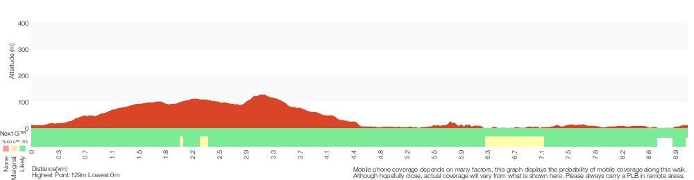
Analysis and summary of the altitude variation on the Wyrrabalong Coast Walk circuit
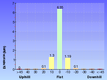
Overview of this walks grade – based on the AS 2156.1 – 2001
Under this standard, a walk is graded based on the most difficult section of the walk.
| Length | 9.1 km | ||
| Time | 3 hrs 30 mins | ||
| . | |||
| Grade 5/6 Experienced only |
AS 2156.1 | Gradient | Short steep hills (3/6) |
| Quality of track | Rough unclear track (5/6) | ||
| Signs | Minimal directional signs (4/6) | ||
| Experience Required | Moderate level of bushwalking experience recommended (4/6) | ||
| Weather | Forecast, unforecast storms and severe weather may impact on navigation and safety (4/6) | ||
| Infrastructure | No facilities provided (5/6) |
Some more details of this walks Grading
Here is a bit more details explaining grading looking at sections of the walk
Gradient
4.8km of this walk has short steep hills and another 3.1km has gentle hills with occasional steps. The remaining (1.2km) is flat with no steps.
Quality of track
2.9km of this walk follows a rough unclear track and another 2.7km follows a formed track, with some branches and other obstacles. Whilst another 1.9km follows a clear and well formed track or trail and the remaining 1.5km follows a rough track, where fallen trees and other obstacles are likely.
Signs
4.4km of this walk has minimal directional signs and another 3.4km has directional signs at most intersection. The remaining (1.2km) is clearly signposted.
Experience Required
4.4km of this walk requires no previous bushwalking experience and another 2.5km requires a leader a with moderate level of bushwalking experience. The remaining (2.1km) requires some bushwalking experience.
weather
6km of this walk is not usually affected by severe weather events (that would unexpectedly impact safety and navigation) and another 2.5km is affected by forecast, unforecast storms and severe weather events that may impact on navigation and safety. The remaining (710m) is affected by storms that may impact your navigation and safety.
Infrastructure
3.1km of this walk is close to useful facilities (such as fenced cliffs and seats) and another 2.3km has limited facilities (such as not all cliffs fenced). Whilst another 2km has no facilities provided and the remaining 1.6km has limited facilities (such as cliffs not fenced, significant creeks not bridged).
Similar walks
A list of walks that share part of the track with the Wyrrabalong Coast Walk circuit walk.
382 m Return
15 mins
Moderate track
646 m One way
15 mins
Moderate track
892 m Circuit
30 mins
Hard track
1.6 km One way
45 mins
Moderate track
1.7 km One way
1 hr 30 mins
Moderate track
3.4 km Return
1 hr 15 mins
Experienced only
3.8 km One way
1 hr 30 mins
Moderate track
4.6 km One way
2 hrs
Experienced only
5.8 km Return
2 hrs 30 mins
Experienced only
Other Nearby walks
A list of walks that start near the Wyrrabalong Coast Walk circuit walk.
166 m Return
10 mins
Very easy
4.8 km Circuit
2 hrs 15 mins
Moderate track
2.9 km One way
1 hr 30 mins
Moderate track
1.2 km Circuit
45 mins
Moderate track
1.5 km One way
45 mins
Moderate track
4.1 km One way
2 hrs
Hard track
2 km Return
1 Hr
Moderate track
890 m Return
30 mins
Easy track
1.6 km Circuit
45 mins
Easy track
5.3 km Circuit
2 hrs 45 mins
Moderate track
8.5 km One way
3 hrs 45 mins
Hard track
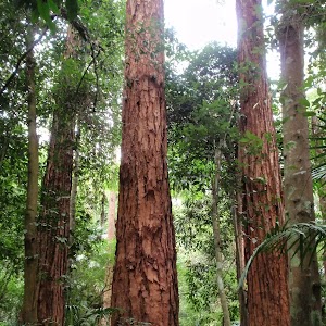
2.3 km Circuit
1 Hr
Moderate track
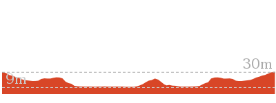
Plan your trip to and from the walk here
The Wyrrabalong Coast Walk circuit walk starts and ends at the Top of northern Bateau Bay Beach access steps (gps: -33.382053, 151.48403)
Your transport options to Top of northern Bateau Bay Beach access steps are by;
![]() Bus. (get details)
Bus. (get details)
![]() Car. There is free parking available.
Car. There is free parking available.
(get details)
Short URL = http://wild.tl/wcwc
Gallery images
There are other downloads I am still working on.
You will probably need to login to access these — still all free.
* KML (google earth file)
* GPX (GPS file)
Special Maps/ brochures
* A3 topo maps
* PDF with Lands Topo map base
* PDF with arial image (and map overlay)
I wanted to get the main site live first, this extra stuff will come in time.
Happy walking
Matt 🙂
Wyrrabalong Lookout to Crackneck Lookout

45 mins
1.6 km One way
56 m
Moderate track
The fantastic scenic walk includes some of the highlights of the longer Wyrrabalong Coast Walking Track. The walk passes through a variety of beautiful forest landscapes, and there are excellent views of the coastline from many spots along the way, including the lookouts at the start and finish of the walk. You could also do this as a return walk to avoid a car shuttle.
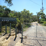
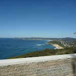

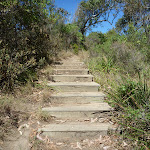
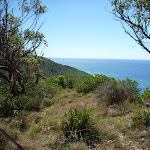
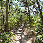
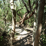
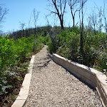

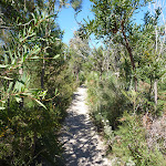

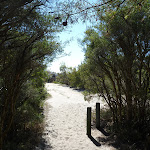
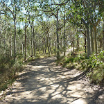
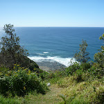
(0km) End of Cromarty Hill Rd → Wyrrabalong Lookout
190 m
4 mins
13m
-7m
Moderate track
From the end of Cromarty Hill Rd, this walk goes around the gate, passing the ‘Wyrrabalong National Park’ sign and following the management trail up the hill. The trail passes between the communications tower and satellite dish. There are great views back over Forresters Beach from the concrete platform on top of the building, next to the tower. The walk then heads across the open grassy area, passing a trig point (to the right) and arriving at the Wyrrabalong Lookout, with beautiful views along the coast and out to sea.
Wyrrabalong Lookout and Cromarty Hill
This lookout and picnic area is on Cromarty Hill, near the end of Cromarty Hill Rd, Forresters Beach. There are picnic tables and fantastic views from the lookout point, as well as the concrete roof platform beside the large communications tower. There is a hang gliding launch spot beside the lookout.
(0.19km) Wyrrabalong Lookout → End of Crackneck management trail
1.2 km
26 mins
32m
-62m
Moderate track
Veer left: From the northern edge of Wyrrabalong Lookout, this walk follows the ‘Coast Track’ arrow, towards ‘Crackneck Lookout’, going down the wooden steps and keeping the ocean to the right. The walk goes down several sets of wooden steps, with occasional ocean views, before emerging briefly at a fenced viewpoint on the clifftops. The walk then passes through thick heath vegetation for a while before climbing a long set of metal stairs. From the top of the stairs, the walk runs along the top of a ridge with extensive views out to sea and inland, then passes a ‘Coastal Heathlands’ information board and arrives at an intersection with a sandy bush track, to the left.
Veer right: From the intersection, this walk follows the sandy bush track north, keeping the ocean to the right. The track passes through lovely bush with plenty of grass trees for a short distance before reaching an intersection with another sandy bush track, to the left, marked with several wooden posts and a signpost (indicating walkers are permitted but no dogs or motorbikes).
Continue straight: From the intersection, this walk follows the sandy bush track north, leaving the signpost behind on the left. After a very short distance, the walk arrives at a junction with the end of a sandy management trail, marked with some timber posts.
(1.36km) End of Crackneck management trail → Crackneck Lookout
270 m
5 mins
11m
-6m
Easy track
Veer left: From the junction at the end of the management trail, this walk follows the management trail north. Ignoring numerous side tracks (some of which lead to clifftop viewpoints), the walk continues along the trail for a while before passing a National Park information board, to the right, then passing around a gate and arriving at Crackneck Lookout.
Crackneck Lookout
This lookout, at the end of Hilltop St, Bateau Bay, has stunning views up and down the coastline, and out to sea. There are picnic tables and an information board about marine mammals. There is a hangliding launch spot beside the lookout.
Maps for the Wyrrabalong Lookout to Crackneck Lookout walk
You can download the PDF for this walk to print a map.
These maps below cover the walk and the wider area around the walk, they are worth carrying for safety reasons.
| Gosford | 1:25 000 Map Series | 91312S GOSFORD | NSW-91312S |
| Gosford | 1:100 000 Map Series | 9131 GOSFORD | 9131 |
Cross sectional view of the Wyrrabalong Lookout to Crackneck Lookout bushwalking track
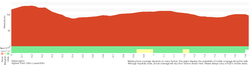
Analysis and summary of the altitude variation on the Wyrrabalong Lookout to Crackneck Lookout
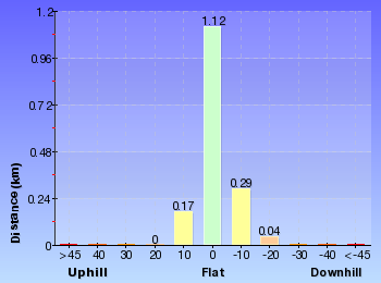
Overview of this walks grade – based on the AS 2156.1 – 2001
Under this standard, a walk is graded based on the most difficult section of the walk.
| Length | 1.6 km | ||
| Time | 45 mins | ||
| . | |||
| Grade 3/6 Moderate track |
AS 2156.1 | Gradient | Short steep hills (3/6) |
| Quality of track | Formed track, with some branches and other obstacles (3/6) | ||
| Signs | Directional signs along the way (3/6) | ||
| Experience Required | No experience required (1/6) | ||
| Weather | Weather generally has little impact on safety (1/6) | ||
| Infrastructure | Limited facilities, not all cliffs are fenced (3/6) |
Some more details of this walks Grading
Here is a bit more details explaining grading looking at sections of the walk
Gradient
920m of this walk has short steep hills and another 680m has gentle hills with occasional steps. The remaining (25m) is flat with no steps.
Quality of track
Around 1.2km of this walk follows a formed track, with some branches and other obstacles, whilst the remaining 460m follows a clear and well formed track or trail.
Signs
Around 1.2km of this walk is clearly signposted, whilst the remaining 430m has directional signs at most intersection.
Experience Required
This whole walk, 1.6km requires no previous bushwalking experience.
weather
This whole walk, 1.6km is not usually affected by severe weather events (that would unexpectedly impact safety and navigation).
Infrastructure
Around 1.4km of this walk is close to useful facilities (such as fenced cliffs and seats), whilst the remaining 240m has limited facilities (such as not all cliffs fenced).
Similar walks
A list of walks that share part of the track with the Wyrrabalong Lookout to Crackneck Lookout walk.
382 m Return
15 mins
Moderate track
646 m One way
15 mins
Moderate track
3.8 km One way
1 hr 30 mins
Moderate track
9.1 km Circuit
3 hrs 30 mins
Experienced only
Other Nearby walks
A list of walks that start near the Wyrrabalong Lookout to Crackneck Lookout walk.
5.8 km Return
2 hrs 30 mins
Experienced only
1.7 km One way
1 hr 30 mins
Moderate track
892 m Circuit
30 mins
Hard track
3.4 km Return
1 hr 15 mins
Experienced only
4.6 km One way
2 hrs
Experienced only
166 m Return
10 mins
Very easy
4.8 km Circuit
2 hrs 15 mins
Moderate track
2.9 km One way
1 hr 30 mins
Moderate track
1.2 km Circuit
45 mins
Moderate track
1.5 km One way
45 mins
Moderate track
4.1 km One way
2 hrs
Hard track
2 km Return
1 Hr
Moderate track
Plan your trip to and from the walk here
The Wyrrabalong Lookout to Crackneck Lookout walk starts at the End of Cromarty Hill Rd (gps: -33.405263, 151.47447)
Your transport options to End of Cromarty Hill Rd are by;
![]() Bus. (get details)
Bus. (get details)
![]() Car. There is free parking available.
Car. There is free parking available.
(get details)
The Wyrrabalong Lookout to Crackneck Lookout ends at the Crackneck Lookout (gps: -33.394205, 151.48302)
Your transport options to Crackneck Lookout are by;
![]() Bus. (get details)
Bus. (get details)
![]() Car. There is free parking available.
Car. There is free parking available.
(get details)
Short URL = http://wild.tl/wltcl
Gallery images
There are other downloads I am still working on.
You will probably need to login to access these — still all free.
* KML (google earth file)
* GPX (GPS file)
Special Maps/ brochures
* A3 topo maps
* PDF with Lands Topo map base
* PDF with arial image (and map overlay)
I wanted to get the main site live first, this extra stuff will come in time.
Happy walking
Matt 🙂
Comments