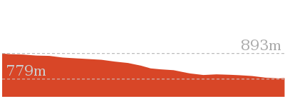
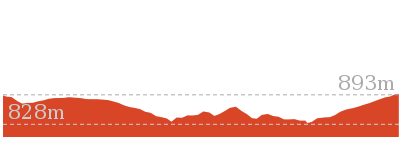
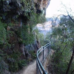
This walk from Wentworth Falls Station is a fantastic way to see a large majority of the Wentworth Falls cliffline. The track winds under and over the cliffs, giving different perspectives of the the Jamison Valley below and waterfalls along the way. Conservation Hut marks the turn-around point for this walk and is a great place to grab some lunch or a coffee for continuing back to the station.
Under and Over Cliff Walk
And Walk
Under and Over Cliff Walk


4 hrs
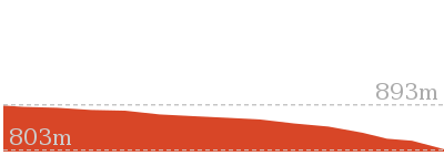
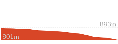
9.4 km Circuit

576 m
Moderate track


(0km) Wentworth Falls Railway Station → Wilson Park

490 m
9 mins
13m
-15m
Very easy
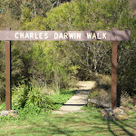
From Wentworth Falls Railway Station, this walk exits the station on the western side, on Station St, and turns left to head down to the Great Western Highway past the shops. At the highway, the walk crosses at the lights and turns right, heading down the hill along the foot path. This walk then turns left into Wilson Park soon after the colourful bus stop. The walk follows the footpath through Wilson Park. At the toilet block in the centre of the park, the walk tends slightly more to the left until coming to a large archway entrance to the Charles Darwin Walk, near the tennis courts.
(0.49km) Wilson Park → Int of Charles Darwin and Parkes St Tracks
540 m
12 mins
20m
-33m
Easy track
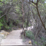
Continue straight: From the south-east corner of Wilson Park (near the tennis courts), this walk heads under the large wooden archway signposted as ‘Charles Darwin Walk’. The walk follows the track passing a blue sign pointing to ‘Wentworth Falls Waterfall’ and soon after crosses the creek on a small wooden bridge. On the other side of the creek the track meanders through the open pine forest. After heading up some steps the track comes to an intersection with a sign pointing back to ‘Wilson Park’ (the steps on the left head up to Page Ave).
Continue straight: From the intersection, this walk passes the blue sign (on the right) and turns right down the steps to immediately come to an intersection just before the bridge (and a ‘Charles Darwin Walk’ sign).
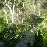
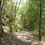
Turn left: From the intersection, this walk follows ‘Charles Darwin walk’ sign downstream, keeping the creek on the right. The track meanders alongside the creek over some timber platforms and through a lovely Banksia grove. Soon the track heads under a pipe bridge and comes to a clearing and intersection.
Continue straight: From the intersection, this walk passes the blue sign (on the right) and turns right down the steps to immediately come to an intersection just before the bridge (and a ‘Charles Darwin Walk’ sign).
Turn left: From the intersection, this walk follows ‘Charles Darwin walk’ sign downstream, keeping the creek on the right. The track meanders alongside the creek over some timber platforms and through a lovely Banksia grove. Soon the track heads under a pipe bridge and comes to a clearing and intersection.
(1.03km) Int of Charles Darwin and Parkes St Tracks → Int of Charles Darwin and Fletcher St Tracks
840 m
17 mins
22m
-44m
Easy track
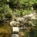
Continue straight: From the intersection near the pipe bridge, this walk follow the ‘Wentworth Falls Waterfall’ sign downstream (keeping the creek on the right). The walk soon passes another track (that crosses the creek using a small bridge on the right) and then passes a bush regeneration sign to leave the clearing. The track meanders alongside the creek for a while before heading down some stairs and crossing the creek on a bridge. On the other side the walk passes a bench seat and then comes to an intersection with the signposted ‘Parkes Street’ track (on the right).
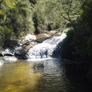
From this intersection, this walk heads downstream (keeping the creek to the left). The walk crosses the creek on a foot bridge and follows the creek closely soon passing a beautiful set of cascades.
After cascades, the walk goes down a steep section of stairs and once again crosses the creek. The track continues along a section of boardwalk before joining up with a track that continues beside the creek. This goes along a mixture of boardwalk and bush track until coming to an intersection with a track, with ‘Fletcher St’ and ‘Falls’ signs.
(1.87km) Int of Charles Darwin and Fletcher St Tracks → Int of Undercliff and Fletchers Lookout Tracks
880 m
16 mins
5m
-36m
Moderate track
Continue straight: From the intersection, this walk follows the creek downstream along a mixture of bush track and boardwalk. The track continues down until crossing two small creeks. Soon after these two small creeks, the track comes to an intersection, with ‘Wentworth Falls’ and ‘National Pass Trail’ signs.
Veer right: From the intersection, this walk heads up the steps following the ‘Wentworth Falls Picnic Area’ sign (keeping the valley to the left). Soon, the track comes to an intersection with a sign pointing back to ‘Weeping Rock Circuit’.
Turn left: From the intersection, this walk follows the ‘Wentworth Falls’ sign down the track. The track soon steepens, heading down the steps and then coming to a four-way intersection, opposite a short track to ‘Fletchers Lookout’.
(2.75km) Int of Undercliff and Fletchers Lookout Tracks → Fletchers Lookout
20 m
1 mins
0m
-7m
Moderate track
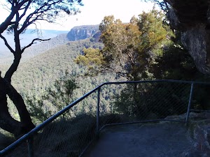
Continue straight: From the intersection, this walk follows the ‘Fletcher Lookout’ sign down the steps. The fenced and signposted lookout has three main bays, two on the left (with views of Wentworth Falls) and a third down the steps, looking into the valley. At the end of this side trip, retrace your steps back to the main walk then Turn left.
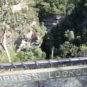
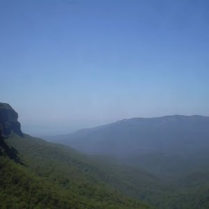
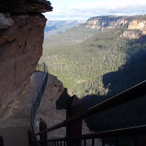
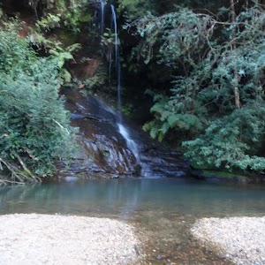
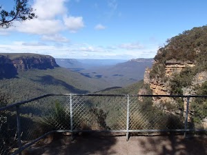
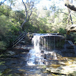
Fletchers Lookout

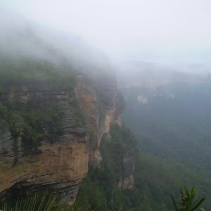
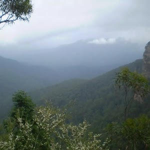
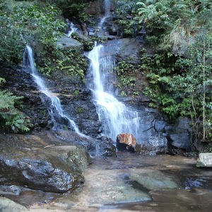
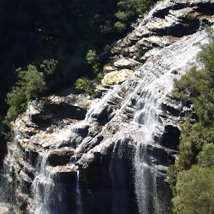
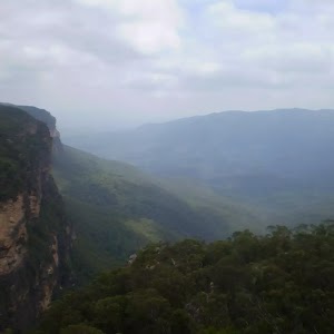
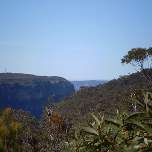
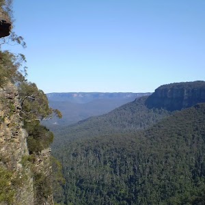
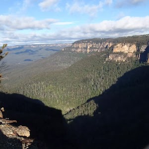
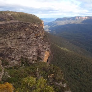
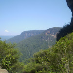
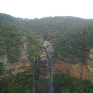
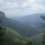
Fletchers Lookout is a fenced and signposted lookout off the side of the Undercliff Walk, just north of the Wentworth Falls. The lookout provides a fairly close view of the top of Wentworth Falls and a great view into the Jamison Valley. There is a good distant view of Mount Solitary and Narrow Neck, and also great views of the surrounding escarpments.
(2.75km) Int of Undercliff and Fletchers Lookout Tracks → Int of Undercliff and Princes Rock Tracks
470 m
22 mins
104m
-89m
Moderate track
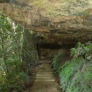
Turn right: From the intersection, this walk follows the ‘Undercliff walk’ sign, keeping the main valley to the left. The track soon passes under three significant and low overhangs (be sure to duck) each with wide sweeping left-hand bends. The first overhang has timber blocks on the floor. Soon after the third overhang, the track comes to a point with a large dead tree and some great valley views.
From the view, this walk keeps the rock wall on the right and soon turns right, passing through a large overhang. On the other end of this overhang, the track comes to an unsignposted ‘Y’ intersection. (The lower left-hand track heads down to Eagles Nest Lookout.)
From the intersection, this walk follows the higher track (keeping the valley view to the left). The track soon bends right, heads up some steps and passes under a large overhang. Soon after this overhang, the walk heads up some steps then comes to a three-way intersection with the ‘Princes Rock’ track (on the right) and a ‘Wentworth Falls’ sign pointing back.
(3.22km) Int of Undercliff and Princes Rock Tracks → Int of Overcliff and Denfenella Lookout Track
460 m
13 mins
32m
-52m
Moderate track
Continue straight: From the intersection, this walk follows the ‘Valley of the Waters’ sign along the track (with filtered views into the valley on the left). The walk soon crosses a small metal bridge and comes to a fenced (unnamed) lookout with great valley views. The walk follows the track back into the bush as it heads around the valley, soon coming to a sandstone overhang with a constructed stone wall, and more great valley views.
From the overhang, the walk continues around the cliff wall, down the metal steps and along the base of the cliff. After passing an interesting rock formation, the track heads through a muddy section then soon bends right. The walk then heads down some steps and soon comes to an intersection just before a footbridge, with a sign pointing back to the ‘Undercliff Walk’.
Turn left: From the intersection, this walk crosses over Den Fenella Creek using the bridge and comes to an intersection at the ‘Den Fenella’ sign.
(3.67km) Int of Overcliff and Den Fenella Lookout Track → Den Fenella Lookout
70 m
4 mins
8m
-51m
Hard track
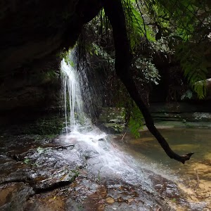
Veer left: From the intersection, this walk follows the ‘Den Fenella’ sign along the lower track, keeping the creek to the left. The track soon begins to go down very steeply (can be slippery) between the handrails and rock wall. The track then crosses the creek at the stepping stones below the cascades (the creek may be impassable after rain). On the other side of the creek, the walk heads down the steps to come to a bridge below the bigger Den Fenella Fall.
From the Den Fenella Fall, this walk crosses the metal bridge and continues along the cliff edge along the fence-lined track. After heading down some steps, the track ends at a fenced point with great views across the valley. At the end of this side trip, retrace your steps back to the main walk then Turn left.
From the Den Fenella Fall, this walk crosses the metal bridge and continues along the cliff edge along the fence-lined track. After heading down some steps, the track ends at a fenced point with great views across the valley. At the end of this side trip, retrace your steps back to the main walk then Turn left.
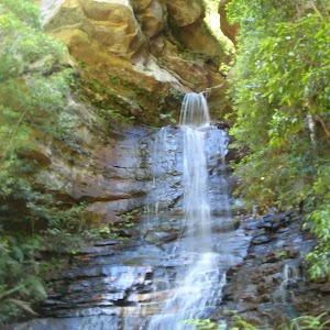
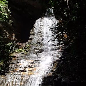
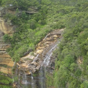
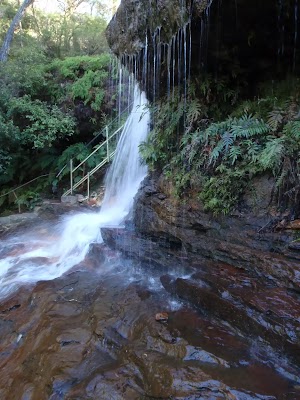
Den Fenella Lookout
The Den Fenella Lookout is a small fenced lookout on a cliff ledge, near where Den Fenella Creek falls into the Jamison Valley. The lookout is at the end of the track and has a tall cliff above and below. There is a small tree on the ledge adding to the sense of depth. From here, there are great views to Mount Solitary (middle), Kings Tableland (left), Narrow Neck Plateau (far right) and Sublime Point (right). This is a great spot, well worth a visit.
(3.67km) Int of Overcliff and Denfenella Lookout Track → Breakfast Point Lookout
230 m
12 mins
74m
-34m
Moderate track
Veer right: From the intersection, this walk heads away from the bridge following the higher track. After about 100m, the track turns right at the next intersection. (The left-hand track heads down to the Lady Sees lookout with a fence in disrepair, currently closed). Soon this walk heads up some steps (around some large boulders) before meandering through the bush for some time. After a little while, the track comes to a three-way intersection and the unsignposted Breakfast Point Lookout.
Breakfast Point Lookout
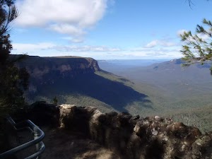
Breakfast Point Lookout is on the Overcliff Walk, west of Den Fenella Creek. The lookout has a short stone wall and great views across the Jamison Valley. The center piece of the view is out to Mount Solitary and beyond, there are also good views to Kings Tableland (left). This is a good spot to stop and enjoy the sweeping views of the majestic valley.
(3.9km) Breakfast Point Lookout → Lyrebird Lookout
640 m
21 mins
75m
-78m
Moderate track
Continue straight: From Breakfast Point Lookout, this walk follows the Overcliff Track west, keeping the valley views to the left. The track soon passes an informal track (on the left) before heading along the base of a large rock wall (on the right). The track then heads up the steps following the handrail – soon after the end of the handrail, the track passes another informal track (on the left). After passing an often muddy section of track, this walk turns left at the intersection, then heads a few meters to the fenced and signposted ‘Lyrebird Lookout’.
Lyrebird Lookout

Lyrebird Lookout is a fenced and signposted lookout on the Overcliff Walk, south of the Conservation Hut in the Blue Mountains National Park. The lookout hosts a great view of Sublime Point (right) and Mount Solitary (centre). A welcome gap in the trees reveals this great view.
(4.54km) Lyrebird Lookout → Int of Valley of the Waters and Overcliff Tracks
220 m
6 mins
34m
-1m
Moderate track
Continue straight: From Lyrebird Lookout, this walk keeps the green fence to the left and follows the track into the bush (with the valley behind and to the left). The walk crosses a section that is normally wet and muddy, and soon comes to a unsignposted ‘Y’ intersection with the Lyrebird Cliff Track on the left.
Continue straight: From the intersection, this walk takes the upper track and heads north-west. This goes up slightly before flattening out and continuing away from the cliffs, until coming to an intersection with a well-managed track, signposted as the Overcliff Track
Continue straight: From the intersection, this walk takes the upper track and heads north-west. This goes up slightly before flattening out and continuing away from the cliffs, until coming to an intersection with a well-managed track, signposted as the Overcliff Track
(4.76km) Int of Valley of the Waters and Overcliff Tracks → Conservation Hut
210 m
5 mins
33m
-2m
Moderate track
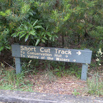
Turn right: From the intersection, this walk follows the ‘National Pass – Tea Rooms’ sign up the steps, with the handrail on the left. After a short time, the track passes a couple of faint tracks (on the right, leading to an old picnic area). Heading up the main steps, the walk passes another handrail (and signs) then an information sign, before coming to a three-way intersection with the ‘Shortcut Track’.
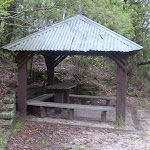
Continue straight: From the intersection, this walk heads up the steps towards the building. The walk passes a couple of picnic shelters (on the right) before coming to the road and the front of the ‘Conservation Hut’.
Continue straight: From the intersection, this walk heads up the steps towards the building. The walk passes a couple of picnic shelters (on the right) before coming to the road and the front of the ‘Conservation Hut’.
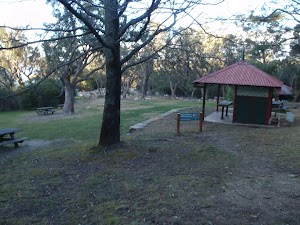
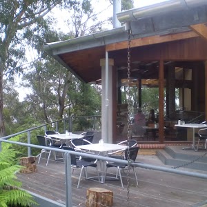
Conservation Hut

Conservation Hut is a small cafe perched above the Valley of the Waters, Blue Mountains National Park. The hut was opened in 1963 as a meeting place for the local conservation movement. Rebuilt, Conservation Hut opened as a cafe in 1993, serving breakfast, lunch and dinner, seven days a week. Around the Conservation Hut is a small parking area, public toilets, picnic shelters, town water and B&B’s. For further information or bookings call (02) 4757 3827. More info.
(4.97km) Conservation Hut → Int of Shortcut and Breakfast Point Lookout Tracks
390 m
9 mins
13m
-24m
Moderate track
Turn around: From Conservation Hut, this walk follows the ‘Valley of the Waters’ sign down some timber and dirt steps passing a couple of picnic shelters. The track soon leads to the signposted intersection with the ‘Short Cut Track’ (still in view of the Conservation Hut).
Turn left : From the intersection, the walk heads along the ‘Short Cut Track’ following the arrow to ‘Wentworth Falls picnic area’. The track gradually heads downhill with small log steps. After a short distance, the walk crosses a small creek using a bridge. The track then bends to the right and continues along till comes to a signposted intersection with another track (on the right).
Continue straight: From the intersection, the walk follows the sign to ‘Wentworth Falls picnic area’ that heads south-east along the flat bush track. Soon the walk comes to a 4-way intersection marked with signs pointing to Breakfast Pt Lookout, Murphy’s Lane and to the Falls Picnic Area.
(5.36km) Int of Shortcut and Breakfast Point Lookout Tracks → Sir H. Burrell Drive Carpark (Nth)
620 m
13 mins
22m
-38m
Easy track
Continue straight: From the intersection, this walk follows the sign to the ‘Falls Picnic Area’, heading east along a flat track. The wide track gently winds through the bush, tending to the right – there are a number of anti-erosion systems in place to step over. Just before opening out into the car park, the track turns right. At the car park is a large ‘Short Cut Track’ sign, pointing back.
Wentworth Falls Picnic Area
The Wentworth Falls Picnic Area is in the Blue Mountains National Park on Sir H Burrell Drive (Wentworth Falls). The picnic area is host to a couple of wonderful lookouts and some good facilities. A large car park, toilets (wheelchair accessible), picnic tables, free electric BBQs, town water and information signs. This is a great spot to relax between walks in the area.
(5.98km) Sir H. Burrell Drive Carpark (Nth) → Wentworth Falls Lookout Picnic Area
220 m
4 mins
7m
-2m
Easy track
Veer left: From the car park on Sir H. Burrell Dr, this walk heads up the steps, passing the toilets, into the Wentworth Falls Picnic Area.
Continue straight: From the Wentworth Falls Picnic Area, this walk heads past the BBQ shelter and follows the track (with a timber border) up the steps (keeping the road a short distance to the left). The track passes an old sandstone pillar marking an overgrown lookout (still with some views). The walk continues up this gentle hill, coming to the main entrance of Wentworth Falls Picnic Area (at the intersection of Falls Rd and Sir H Burrell Dr).
Continue straight: From the Wentworth Falls Picnic Area, this walk heads past the BBQ shelter and follows the track (with a timber border) up the steps (keeping the road a short distance to the left). The track passes an old sandstone pillar marking an overgrown lookout (still with some views). The walk continues up this gentle hill, coming to the main entrance of Wentworth Falls Picnic Area (at the intersection of Falls Rd and Sir H Burrell Dr).
(6.19km) Entrance Wentworth Falls Lookout Picnic Area → Wentworth Falls Lookout
140 m
4 mins
1m
-16m
Moderate track
Veer right: From the Entrance of the Wentworth Falls Lookout Picnic Area (at the intersection of Falls Rd and Burrell Dr), this walk follows the ‘Wentworth Falls Lookout 100m’ sign downhill along the track, passing the old picnic shelter. Soon the track becomes steeper and heads down a series of log steps until coming to and crossing Sir H Burrell Drive. On the other side of the road is the signposted ‘Wentworth Falls Lookout’.
Wentworth Falls Lookout
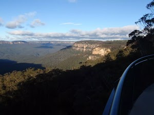
Wentworth Falls Lookout, in the Blue Mountains National Park, is beside Sir H Burrell Drive. The lookout is fenced and has a large information sign about the area. There are some bench seats and great vistas. There is a view to Wentworth Falls (in the valley to the left), but the most captivating view is across the Jamison Valley to Mount Solitary. There are also great views of the Kings Tableland (left), Sublime Point (right) and Narrow Neck (far right) escarpments. This is a great place to enjoy the scope of this World Heritage listed area.
(6.34km) Wentworth Falls Lookout → Int of Wentworth Falls and Weeping Rock Tracks (Nth)
330 m
8 mins
4m
-52m
Easy track
Turn left: From Wentworth Falls Lookout, this walk follows the ‘Wentworth Falls Track’ – ‘To The Falls’ sign down the hill (with the view to the right). The walk heads down the log steps, passing several information signs. The track soon heads through a sharp right-hand bend, then comes to an intersection (with a track closed at the time of writing) at the sharp left bend. There is a sign here, pointing back up to ‘Wentworth Falls picnic area’.
Turn left: From the intersection, this walk heads downhill following the ‘Wentworth Falls – National Pass’ sign. The walk gradually descends the well-maintained log stairs, passing some views of the valley on the right. Soon the track comes to an intersection with another sign, pointing back up to ‘Wentworth Falls Picnic Area’.
Turn left: From the intersection, this walk heads downhill following the ‘Wentworth Falls – National Pass’ sign. The walk gradually descends the well-maintained log stairs, passing some views of the valley on the right. Soon the track comes to an intersection with another sign, pointing back up to ‘Wentworth Falls Picnic Area’.
(6.67km) Int of Wentworth Falls and Weeping Rock Tracks (Nth) → Int of Charles Darwin and Fletcher St Tracks
820 m
14 mins
25m
-5m
Moderate track
Veer left: From the intersection, this walk follows the ‘Weeping Rock Circuit’ sign down the steps, (with the valley to the right). Soon, the track comes to an intersection with ‘Darwins Track’ (on the left).
Veer left: From the intersection, this walk heads alongside Jamison Creek (creek to the right)following the signs along the Charles Darwin Walk. The track soon crosses two small streamlets and continues up the main creek along a mixture of bush track and boardwalk. This passes a great section of overhanging cliff on the other side of the creek. After this, the track rises slightly before going down to an intersection with a track signposted as the way up to Fletcher St, on the left.
Veer left: From the intersection, this walk heads alongside Jamison Creek (creek to the right)following the signs along the Charles Darwin Walk. The track soon crosses two small streamlets and continues up the main creek along a mixture of bush track and boardwalk. This passes a great section of overhanging cliff on the other side of the creek. After this, the track rises slightly before going down to an intersection with a track signposted as the way up to Fletcher St, on the left.
(7.49km) Int of Charles Darwin and Fletcher St Tracks → Int of Charles Darwin Track and Wentworth Falls Fire Station Trail
1.2 km
25 mins
68m
-38m
Easy track
Continue straight: From the intersection, this walk heads upstream beside the creek. This track goes along a mixture of boardwalk and bush track until continuing on a long section of boardwalk. The walk crosses the creek and goes up a steep set of stairs, then past a beautiful section of creek where the water cascades down the rocks.
Shortly the cascades, the track crosses the creek using a foot bridge and comes to a signposted intersection with ‘Parkes Street’ track (on the left).
From the intersection, this walk follows the clear track upstream (keeping the creek through the bush, on the right). The track bends right passing a bench seat and crossing the creek on a footbridge. On the other side of the bridge the walk climbs the stairs then gently meanders along the side of the creek till coming to a clearing. On the other side of the clearing the walk comes to an intersection just before the pipe bridge.
Continue straight: From the intersection, this walk follows ‘Village’ sign along the track and under the large pipeline (keeping Jamison Creek on the left). The track meanders alongside the creek over some timber platforms and through a lovely Banksia grove. After a short time the walk passes a ‘Charles Darwin walk’ sign and comes to an intersection with a timber bridge on the left of the track.
(8.66km) Int of Charles Darwin Track and Wentworth Falls Fire Station Trail → Wilson Park
220 m
4 mins
9m
-4m
Easy track
Turn right: From the intersection, this walk heads up the stairs (away from the bridge and creek) and turns left. The walk almost immediately comes to an intersection with a set of stairs (heading up to Page Ave on the right) and a sign pointing to ‘Wilson Park’.
Continue straight: From the intersection, this walk follows ‘Wilson Park’ and ‘Village’ signs down some steps and along the track (keeping the creek to the left). The track soon passes a bush regeneration information sign and heads into an open pine forest. The walk then crosses the creek on a small timber bridge and heads up the hill. Soon the track passes under the ‘Charles Darwin Walk’ arch and enters Wilson Park (just next to the tennis courts).
Continue straight: From the intersection, this walk follows ‘Wilson Park’ and ‘Village’ signs down some steps and along the track (keeping the creek to the left). The track soon passes a bush regeneration information sign and heads into an open pine forest. The walk then crosses the creek on a small timber bridge and heads up the hill. Soon the track passes under the ‘Charles Darwin Walk’ arch and enters Wilson Park (just next to the tennis courts).
(8.87km) Wilson Park → Wentworth Falls Railway Station
490 m
9 mins
15m
-13m
Very easy
Continue straight: From the the archway in Wilson Park, this walk heads away from the tennis courts, keeping the creek on the right. At the far end of the park, the walk comes to the Great Western Highway and turns right. After about 150m, this walk crosses the highway at the traffic lights and heads up Station St, past the shops and up to Wentworth Falls Railway Station on the right.
Maps for the Under and Over Cliff Walk walk
You can download the PDF for this walk to print a map.
These maps below cover the walk and the wider area around the walk, they are worth carrying for safety reasons.
| Katoomba | 1:25 000 Map Series | 89301S KATOOMBA | NSW-89301S |
| Katoomba | 1:100 000 Map Series | 8930 KATOOMBA | 8930 |
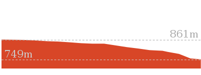
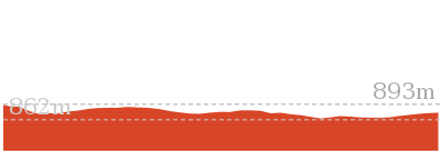
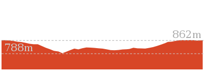
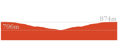
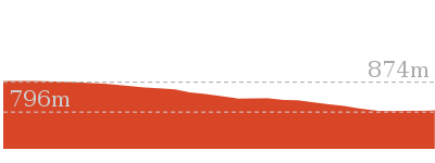
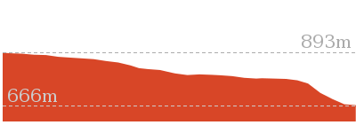
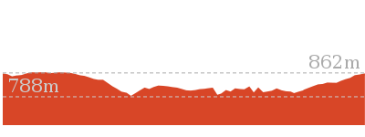
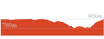
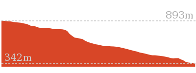
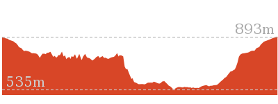
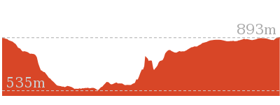
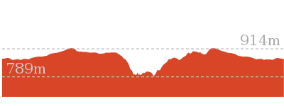
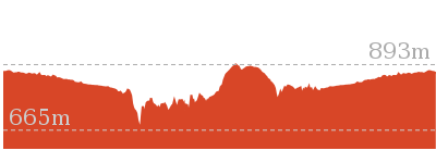
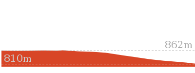
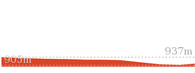
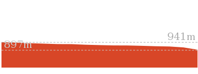
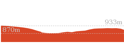
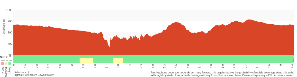
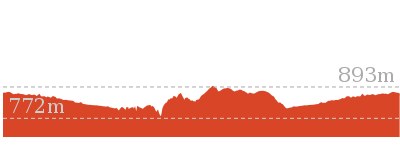
Cross sectional view of the Under and Over Cliff Walk bushwalking track
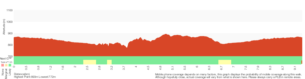
Analysis and summary of the altitude variation on the Under and Over Cliff Walk
Overview of this walks grade – based on the AS 2156.1 – 2001
Under this standard, a walk is graded based on the most difficult section of the walk.
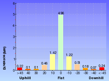
| Length | 9.4 km | ||
| Time | 4 hrs | ||
| . | |||
| Grade 3/6 Moderate track |
AS 2156.1 | Gradient | Short steep hills (3/6) |
| Quality of track | Formed track, with some branches and other obstacles (3/6) | ||
| Signs | Directional signs along the way (3/6) | ||
| Experience Required | Some bushwalking experience recommended (3/6) | ||
| Weather | Storms may impact on navigation and safety (3/6) | ||
| Infrastructure | Limited facilities, not all cliffs are fenced (3/6) |
Some more details of this walks Grading
Here is a bit more details explaining grading looking at sections of the walk
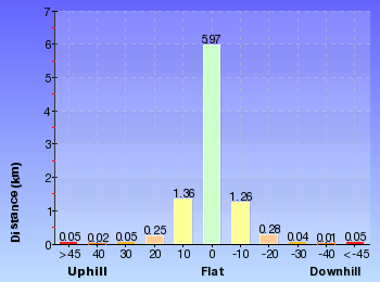
Gradient
6km of this walk has gentle hills with occasional steps and another 1.7km is flat with no steps. The remaining (1.4km) has short steep hills.
Quality of track
4.2km of this walk follows a smooth and hardened path and another 3.9km follows a clear and well formed track or trail. The remaining (1.3km) follows a formed track, with some branches and other obstacles.
Signs
Around 7km of this walk is clearly signposted, whilst the remaining 2.6km has directional signs at most intersection.
Experience Required
Around 8km of this walk requires no previous bushwalking experience, whilst the remaining 1.2km requires some bushwalking experience.
weather
Around 9km of this walk is not usually affected by severe weather events (that would unexpectedly impact safety and navigation), whilst the remaining 640m is affected by storms that may impact your navigation and safety.
Infrastructure
Around 7km of this walk is close to useful facilities (such as fenced cliffs and seats), whilst the remaining 1.9km has limited facilities (such as not all cliffs fenced).
Similar walks
A list of walks that share part of the track with the Under and Over Cliff Walk walk.
696 m Return
30 mins
Moderate track
762 m Return
30 mins
Moderate track

926 m Return
45 mins
Hard track
950 m Circuit
30 mins
Moderate track
1.1 km One way
30 mins
Moderate track
1.1 km Return
1 Hr
Hard track
1.3 km Circuit
45 mins
Moderate track
1.3 km Return
1 Hr
Moderate track
1.4 km Circuit
45 mins
Moderate track
1.5 km Return
45 mins
Moderate track
1.5 km Return
1 hr 30 mins
Hard track
1.7 km Circuit
1 Hr
Hard track

1.9 km Circuit
1 Hr
Moderate track
2 km Circuit
1 hr 30 mins
Moderate track

2.2 km Circuit
1 hr 30 mins
Hard track
3.1 km Circuit
2 hrs
Hard track
3.6 km One way
3 hrs
Hard track
3.8 km Return
4 hrs
Experienced only
4 km Circuit
2 hrs
Moderate track
4.6 km Circuit
3 hrs 30 mins
Hard track
4.8 km Circuit
4 hrs
Hard track
5 km Circuit
4 hrs
Hard track
5.1 km Circuit
4 hrs
Hard track
5.6 km Return
2 hrs
Moderate track
6.7 km Circuit
3 hrs
Hard track
8.6 km Circuit
5 hrs
Hard track

8.9 km Circuit
4 hrs 30 mins
Hard track
9.5 km Circuit
5 hrs 30 mins
Hard track
10.2 km Circuit
6 hrs
Hard track

29.2 km One way
2 Days
Experienced only

29.3 km One way
3 Days
Experienced only

Other Nearby walks
A list of walks that start near the Under and Over Cliff Walk walk.
880 m Return
30 mins
Moderate track

1.6 km Return
1 Hr
Moderate track
746 m Return
45 mins
Moderate track
1.6 km One way
45 mins
Easy track

2.9 km Return
1 hr 30 mins
Moderate track
538 m Return
30 mins
Moderate track
1.6 km One way
1 Hr
Moderate track
752 m Return
30 mins
Moderate track
1.4 km Circuit
1 Hr
Moderate track
600 m Return
30 mins
Moderate track
844 m Circuit
30 mins
Moderate track

Plan your trip to and from the walk here
The Under and Over Cliff Walk walk starts and ends at the Wentworth Falls Railway Station (gps: -33.709737, 150.37644)
Your transport options to Wentworth Falls Railway Station are by;
![]() Train. (get details)
Train. (get details)
![]() Bus. (get details)
Bus. (get details)
![]() Car. There is free parking available.
Car. There is free parking available.
(get details)


Short URL = http://wild.tl/uaocw
Gallery images
There are other downloads I am still working on.
You will probably need to login to access these — still all free.
* KML (google earth file)
* GPX (GPS file)
Special Maps/ brochures
* A3 topo maps
* PDF with Lands Topo map base
* PDF with arial image (and map overlay)
I wanted to get the main site live first, this extra stuff will come in time.
Happy walking
Matt 🙂
Wentworth Falls Station Loop
And Walk
Wentworth Falls Station Loop

5 hrs 30 mins
9.5 km Circuit
1030 m
Hard track
The Wentworth Falls Station Loop takes in most of the upper tracks around Wentworth Falls. There are many scenic views near the cliffs, with a few highlights away from the cliffs such as Lillians Glen and the Conservation Hut. This walk takes some time, so be sure to bring a packed lunch or buy something delicious from the scenic Conservation Hut restaurant.
Closed:


(0km) Wentworth Falls Railway Station → Wilson Park
490 m
9 mins
13m
-15m
Very easy
From Wentworth Falls Railway Station, this walk exits the station on the western side, on Station St, and turns left to head down to the Great Western Highway past the shops. At the highway, the walk crosses at the lights and turns right, heading down the hill along the foot path. This walk then turns left into Wilson Park soon after the colourful bus stop. The walk follows the footpath through Wilson Park. At the toilet block in the centre of the park, the walk tends slightly more to the left until coming to a large archway entrance to the Charles Darwin Walk, near the tennis courts.
(0.49km) Wilson Park → Int of Charles Darwin and Parkes St Tracks
540 m
12 mins
20m
-33m
Easy track
Continue straight: From the south-east corner of Wilson Park (near the tennis courts), this walk heads under the large wooden archway signposted as ‘Charles Darwin Walk’. The walk follows the track passing a blue sign pointing to ‘Wentworth Falls Waterfall’ and soon after crosses the creek on a small wooden bridge. On the other side of the creek the track meanders through the open pine forest. After heading up some steps the track comes to an intersection with a sign pointing back to ‘Wilson Park’ (the steps on the left head up to Page Ave).
Continue straight: From the intersection, this walk passes the blue sign (on the right) and turns right down the steps to immediately come to an intersection just before the bridge (and a ‘Charles Darwin Walk’ sign).
Turn left: From the intersection, this walk follows ‘Charles Darwin walk’ sign downstream, keeping the creek on the right. The track meanders alongside the creek over some timber platforms and through a lovely Banksia grove. Soon the track heads under a pipe bridge and comes to a clearing and intersection.
(1.03km) Int of Charles Darwin and Parkes St Tracks → Int of Charles Darwin and Fletcher St Tracks
840 m
17 mins
22m
-44m
Easy track
Continue straight: From the intersection near the pipe bridge, this walk follow the ‘Wentworth Falls Waterfall’ sign downstream (keeping the creek on the right). The walk soon passes another track (that crosses the creek using a small bridge on the right) and then passes a bush regeneration sign to leave the clearing. The track meanders alongside the creek for a while before heading down some stairs and crossing the creek on a bridge. On the other side the walk passes a bench seat and then comes to an intersection with the signposted ‘Parkes Street’ track (on the right).
From this intersection, this walk heads downstream (keeping the creek to the left). The walk crosses the creek on a foot bridge and follows the creek closely soon passing a beautiful set of cascades.
After cascades, the walk goes down a steep section of stairs and once again crosses the creek. The track continues along a section of boardwalk before joining up with a track that continues beside the creek. This goes along a mixture of boardwalk and bush track until coming to an intersection with a track, with ‘Fletcher St’ and ‘Falls’ signs.
(1.87km) Int of Charles Darwin and Fletcher St Tracks → Weeping Rock waterfall
820 m
14 mins
3m
-26m
Moderate track
Continue straight: From the intersection, this walk follows the creek downstream along a mixture of bush track and boardwalk. The track continues down until crossing two small creeks. Soon after these two small creeks, the track comes to an intersection, with ‘Wentworth Falls’ and ‘National Pass Trail’ signs.
Veer left: From the intersection, this walk heads down the steps following the ‘Weeping Rock Circuit’ sign to the creek a short distance away. Soon the track comes beside Jamison Creek, a lovely flat section of the creek on top of the waterfall. The track continues downstream and across a slippery rockshelf and down a staircase beside the falls. At the bottom of the stairs is another slippery rock platform and a pool at the bottom of Weeping Rock waterfall.
Veer left: From the intersection, this walk heads down the steps following the ‘Weeping Rock Circuit’ sign to the creek a short distance away. Soon the track comes beside Jamison Creek, a lovely flat section of the creek on top of the waterfall. The track continues downstream and across a slippery rockshelf and down a staircase beside the falls. At the bottom of the stairs is another slippery rock platform and a pool at the bottom of Weeping Rock waterfall.
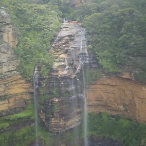
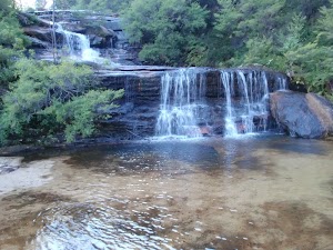
Weeping Rock
Weeping Rock is a waterfall on Jamison Creek, upstream of Wentworth Falls in the Blue Mountains National Park. The water falls over the wide circular top overhang, to then cascade down the rocks to a pool below. A staircase beside the falls helps walkers view this waterfall from different angles. This is a nice cool spot on hot days. The rocks are slippery and there are no fences, care is needed.
(2.69km) Weeping Rock waterfall → Int of Weeping Rock and Wentworth Falls Tracks
40 m
1 mins
0m
-8m
Moderate track
Continue straight: From the bottom of Weeping Rock waterfall, this walk heads downstream (keeping the creek to the left), up some steps and passes another great view of Weeping Rock. After passing between some large rocks, the walk comes to a 3-way intersection, with a sign pointing back to ‘Weeping Rock Circuit’ and ‘Darwins Walk’.
(2.73km) Int of Weeping Rock and Wentworth Falls Tracks → Top of Wentworth Falls
60 m
1 mins
3m
-2m
Moderate track
Turn left: From the intersection, this walk follows the ‘Wentworth Falls’ and ‘Wentworth Pass’ signs down the steps. The track soon comes to a nice view of Jamison Creek, where it continues to wind down the hill and open up at a fenced rock platform at the top of Wentworth Falls. Here the walk crosses Jamison Creek using the stepping stones, to reveal a lovely waterhole and Queen’s Cascades(the creek may be impassable after rain). This is the top of the Wentworth Falls.
Queen’s Cascades
Queen’s Cascades[1] are a lovely set of falls on the Jamison Creek at the top of Wentworth Falls. The creek heads down the wide, two-stage cascades into a sandy pool. From the pool, the water flows between the stepping stones, under the fence and down the very tall Wentworth Falls. There are also great views to Sublime Point across the valley.
(2.79km) Top of Wentworth Falls → Rocket Point Creek Intersection
30 m
1 mins
2m
-6m
Moderate track
Continue straight: From the top of Wentworth Falls, this walk heads away from the falls (keeping the valley view to the right). With the handrail on the right, the track soon crosses a small creek and comes to a three-way intersection and a ‘Rocket Point Circuit’ sign.
Grand Stairway
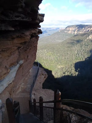
The Grand Stairway is a very memorable section of the National Pass in the Blue Mountains National Park. The stairway is reported to be ‘the tallest outdoor staircase in Australia’ and was built in the early 1900’s by hand (and dynamite). This stairway, and the rest of the National Pass, was built by a team nicknamed ‘the Irish Brigade’ for the cost of £430 . Today, the Grand Stairway is well-maintained and provides walkers access to the valley below Wentworth Falls.
(2.81km) Rocket Point Creek Intersection → Middle Wentworth Falls
330 m
16 mins
36m
-98m
Hard track
Continue straight: From the intersection, this walk follows the ‘National Pass To Wentworth Pass’ sign along the clear track, keeping the handrail on the right. The track soon comes to the cliff. From here the National Pass heads though a series of sandstone caves and down plenty of stairs, most of which are cut into the stone. The views into the valley and of Wentworth Falls are stunning.
After passing a fairly long rock-shelf at the bottom of the timber stairs (and the square hole in the cliff), this walk heads down a long set of steep stone stairs to come to a fenced ‘No Access Cliff Point’ area. From here, the pass continues down more steep stone stairs until reaching the moister area at the bottom of the cliff. The track continues down the hill along the steps and stepping stones. As the track approaches the creek, it zigzags down to the stone-slab bridges and crosses Jamison Creek. From here, there is a small side track up to the pool, at the bottom of the falls (halfway down the main Wentworth Falls).
After passing a fairly long rock-shelf at the bottom of the timber stairs (and the square hole in the cliff), this walk heads down a long set of steep stone stairs to come to a fenced ‘No Access Cliff Point’ area. From here, the pass continues down more steep stone stairs until reaching the moister area at the bottom of the cliff. The track continues down the hill along the steps and stepping stones. As the track approaches the creek, it zigzags down to the stone-slab bridges and crosses Jamison Creek. From here, there is a small side track up to the pool, at the bottom of the falls (halfway down the main Wentworth Falls).
Middle of Wentworth Falls
The National Pass crosses Wentworth Falls halfway down its long drop. At this crossing, NPWS have installed sandstone block bridges to improve access for walkers. There are a few side tracks that have been used to explore the area – beware of the slippery rocks and unfenced ledges. There is also a great view into the valley from where the water continues to fall on it long journey further into the valley. This is a lovely spot to cool down on a warm day.
(3.14km) Middle Wentworth Falls → Top of the Slack Stairs
270 m
19 mins
117m
-88m
Moderate track
Continue straight: From pool and creek crossing (halfway up Wentworth Falls), this walk follows the track (keeping the main valley to the left) away from the falls. The track heads across the rock-platform and timber bridge, with the handrail on the left, then up a series of steep stairs. As the track flattens out, it winds around the side of the valley at the base of a large cliff (on the right). Following the stepping stones, the track heads under a low sandstone overhang (be sure to duck) – past this overhang, there are great views back to the waterfall. The track then rounds the corner to the right, coming to an intersection marked with a ‘National Pass’ sign and a sign pointing back to ‘Wentworth Falls’ (at the top of ‘Slack Stairs’).
(3.41km) Top of the Slack Stairs → Int of Valley of the Waters and National Pass Tracks
1.5 km
1 hr 23 mins
410m
-411m
Moderate track
Continue straight: From the intersection at the top of ‘Slack Stairs’, this walk follows the ‘National Pass – Valley of the Waters’ sign up the few steps, keeping the main valley to the left. The walk soon crosses a creek (and waterfall) using the stepping stones. The walk continues along the cliff-line, up the stairs and along more stepping stones to pass over a couple of smaller creeks. Soon after passing a great vantage point, the walk comes to a handrailed timber platform that passes behind a waterfall from Den Fenella Creek.
From the Den Fenella Creek waterfall, this walk heads along the path, keeping the valley views to the left. After passing a few open ledges with great valley views, the walk heads into another valley and crosses a small creek. The walk continues along the cliff line as it bends right, into the Valley of the Waters, passing a sandstone bench seat and few small creeks. The walk then crosses a timber platform through a sandstone overhang then heads down the stairs to a lovely ferntree valley. From here, the walk continues down the stairs, soon coming to an intersection with Wentworth Pass and a ‘National Pass – Wentworth Falls’ sign pointing back.
From the Den Fenella Creek waterfall, this walk heads along the path, keeping the valley views to the left. After passing a few open ledges with great valley views, the walk heads into another valley and crosses a small creek. The walk continues along the cliff line as it bends right, into the Valley of the Waters, passing a sandstone bench seat and few small creeks. The walk then crosses a timber platform through a sandstone overhang then heads down the stairs to a lovely ferntree valley. From here, the walk continues down the stairs, soon coming to an intersection with Wentworth Pass and a ‘National Pass – Wentworth Falls’ sign pointing back.
(4.86km) Int of Valley of the Waters and National Pass Tracks → Lodore Falls
20 m
1 mins
14m
0m
Moderate track
Veer right: From the intersection, this walk follows the ‘National Pass – Conservation Hut’ sign up the steps, keeping the creek to the left. After heading under the overhang and up the timber steps, the walk crosses the Valley Of the Waters Creek in front of Lodore Falls (using the stepping stones). This creek may be impassable after rain.
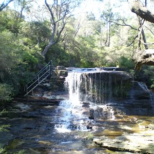
Lodore Falls
Lodore Falls are a lovely set of falls on the Valley of the Waters Creek. The narrow falls have a staircase on one side and stepping stones (and handrail) crossing the bottom, making it easier for walkers to appreciate this waterfall from many angles. Just beyond the handrail, the water falls over another cliff, providing a great view down the valley.
(4.88km) Lodore Falls → Empress Falls Crossing
70 m
2 mins
9m
0m
Hard track
Continue straight: From Lodore Falls, this walk heads upstream, up the staircase, keeping the creek on the right. The steps climb to the base of a wider cascade – Sylvia Falls.
From Sylvia Falls, this walk heads up the stairs, keeping the handrail and creek to the right. The path heads up the hill, passing a ‘Track’ sign before coming to a creek crossing in front of the tall Empress Falls.
From Sylvia Falls, this walk heads up the stairs, keeping the handrail and creek to the right. The path heads up the hill, passing a ‘Track’ sign before coming to a creek crossing in front of the tall Empress Falls.
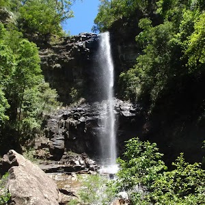
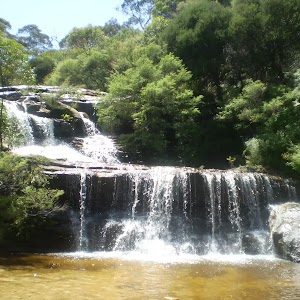
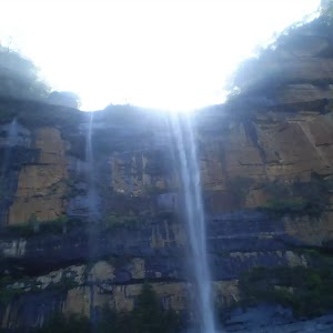
Empress Falls
Empress Falls is a spectacular waterfall in the Valley of the Waters. The Valley of the Water Creek comes out of the slot in the cliff and tumbles down a series of cliffs to a sandy pool. The fall is the site of the last abseil in a popular canyon, making a great site for walkers in the area. Stepping stones help walkers cross below the falls. There is a small overhang next to the falls, giving the area shade and offering a great place to rest.
(4.95km) Empress Falls Crossing → Int of Valley of the Waters and Nature Tracks
90 m
2 mins
14m
-4m
Moderate track
Continue straight: From the bottom of Empress Falls, this walk crosses the creek using the stepping stones, keeping the handrail on the left. On the way up the hill, the walk passes closer to Empress Falls before zigzagging up to a sandstone overhang and timber staircase. At the top of the staircase, the walk crosses Isabel Creek using the stepping stones. The track then winds up the hill, soon coming to an intersection with the ‘Nature Track’ and a sign pointing back to ‘National Pass – Valley of the Waters’. (These creeks may not be passable after rain)
(5.04km) Int of Valley of the Waters and Nature Tracks → Empress Lookout
90 m
4 mins
20m
-12m
Hard track
Turn right: From the intersection, this walk heads up the wooden steps, following the ‘National Pass – Tea Rooms’ sign. The walk soon heads though a long rock overhang to the base of a metal staircase. The walk climbs the series of steep metal staircases zigzagging up the hill. After climbing some wooden steps, the walk comes to the fenced and signposted ‘Empress Lookout’.
Empress Lookout
Empress Lookout is a fenced and signposted lookout, perched on a sandstone overhang above the Valley of the Waters Creek. There is a view down to part of the Empress Falls and into the canyon. The views are filtered through the surrounding trees. It makes for a good spot to catch your breath when walking into, or out of, the Valley of the Waters.
(5.13km) Empress Lookout → Int of Valley of the Waters and Queen Victoria Tracks
60 m
2 mins
18m
0m
Easy track
Turn left: From the Empress Lookout, this walk heads up the wooden steps away from the lookout. The walk heads up the hill, soon passing under a sandstone overhang then up more steps, coming to a ‘Y’ intersection with the signposted ‘Queen Victoria Lookout’ track (on the right).
(5.19km) Int of Valley of the Waters and Queen Victoria Tracks → Queen Victoria Lookout
20 m
1 mins
0m
-17m
Easy track
Turn right: From the intersection, this walk follows the ‘Queen Victoria Lookout’ sign down the steps towards the handrail. Soon the track passes a small lookout on the left and, shortly afterwards, the fence leads to the rock platform and fenced ‘Queen Victoria Lookout’. At the end of this side trip, retrace your steps back to the main walk then Turn right.
Queen Victoria Lookout
The Queen Victoria Lookout is perched above the Valley of the Waters, south-west of Conservation Hut. The fenced lookout has views into the narrow section of the valley. The views are made more dramatic by the roar of the waterfalls below and the mists which frequent the area. Empress Falls are only just visible – the main views extend down Jamison Valley. Kings Tableland (left) and Sublime Point(right) dominate the views and the eastern edge of Mount Solitary and beyond is also visible.
(5.19km) Int of Valley of the Waters and Queen Victoria Tracks → Conservation Hut
320 m
8 mins
75m
-2m
Moderate track
Veer left: From the intersection, this walk heads away from ‘Queen Victoria Lookout’ up the set of stairs to almost immediately come to a ‘Y’ intersection with the unsignposted Lyrebird Cliff track (on the right).
Continue straight: From the intersection, this walk heads up the timber and dirt steps, away from the valley views. The track passes a few faint tracks (on the right, that lead to an unfenced view point). The track soon comes to a signposted intersection with the ‘Overcliff Track’.
Continue straight: From the intersection, this walk follows the ‘National Pass – Tea Rooms’ sign up the steps, with the handrail on the left. After a short time, the track passes a couple of faint tracks (on the right, leading to an old picnic area). Heading up the main steps, the walk passes another handrail (and signs) then an information sign, before coming to a three-way intersection with the ‘Shortcut Track’.
Continue straight: From the intersection, this walk heads up the steps towards the building. The walk passes a couple of picnic shelters (on the right) before coming to the road and the front of the ‘Conservation Hut’.
Conservation Hut
Conservation Hut is a small cafe perched above the Valley of the Waters, Blue Mountains National Park. The hut was opened in 1963 as a meeting place for the local conservation movement. Rebuilt, Conservation Hut opened as a cafe in 1993, serving breakfast, lunch and dinner, seven days a week. Around the Conservation Hut is a small parking area, public toilets, picnic shelters, town water and B&B’s. For further information or bookings call (02) 4757 3827. More info.
(5.51km) Conservation Hut → Int of Valley of the Waters and Nature Tracks
470 m
14 mins
14m
-113m
Hard track
Turn around: From Conservation Hut, this walk follows the ‘Valley of the Waters’ sign down some timber and dirt steps passing a couple of picnic shelters. The track soon leads to the signposted intersection with the ‘Short Cut Track’ (still in view of the Conservation Hut).
Continue straight: From the intersection, this walk follows the ‘Valley of the Waters’ sign down the steps, passing an information sign. After the handrail and more signs, the track passes a couple of faint tracks (on the left, leading to an old picnic area). Further down the steps, the walk comes the end of another handrail and a three-way intersection (signposted ‘Overcliff Track’ and ‘National Pass’).
Continue straight: From the intersection, this walk follows the ‘National Pass – Valley of the Waters’ sign down the timber steps. The track passes a few faint tracks (on the left, that lead to an unfenced view point). The walk continues down the steps, soon coming to an unsignposted intersection with the Lyrebird Cliff track (on a small sandstone rock platform).
Continue straight: From the intersection, this walk heads down the wooden steps to almost immediately come to the signposted intersection with ‘Queen Victoria Lookout’ track.
Veer right: From the intersection, this walk heads down the steps away from ‘Queen Victoria Lookout’ keeping the rock face to the right. The track soon passes under a sandstone overhang and then down more steps to come to the fenced and signposted ‘Empress Lookout’.
Turn right: From Empress Lookout, this walk heads down the wooden steps, keeping the handrail and valley to the left. Soon the walk heads downs a series of steep metal staircases that zigzag down the hill. At the bottom of the staircases, the walk follows the handrail through a long sandstone overhang. The track then heads down some steps to come to an intersection with the ‘Nature Track’ and a sign pointing back to ‘National Pass – Tea Rooms’.
(5.99km) Int of Valley of the Waters and Nature Tracks → Lillians Glen
430 m
13 mins
42m
-43m
Moderate track
Veer right: From the intersection, this walk follows the ‘Nature Track’ sign down a few steps and over a small wooden bridge, coming to a clearing, picnic table and small waterfall.
From the picnic table, this walk heads up the steps, passing a ‘Welcome to the Nature Track’ information sign (point 1). The track turns right and passes three numbered posts (2,3,4) – After number 3, the track heads down hill. Soon after the handrail starts, the walk comes to an intersection just before Lillian’s Bridge and post number 5.
Continue straight: From post number 5 at Lillian’s Bridge, this walk heads up the stairs away from the handrail, keeping the bridge and valley to the left. The track makes its way around the hill, passing a few handrails before heading down to some stepping stones across the creek. (This is a nice but slippery spot to enjoy, with a small waterfall to the right). After crossing the stepping stones, the track heads over a small rise to come back down and cross the creek again, on another set of stepping stones. This is signposted ‘Lillians Glen’.
Lillian’s Glen
Lillian’s Glen is a moss and fern filled section on the ‘Valley of the Waters’ Creek (where the Nature Track crosses the creek, south of Edinburgh Castle Rock). There are stepping stones to help cross the creek. Lillian’s Glen is a great spot to rest and enjoy the area, especially on warmer days. For the sure-footed, a short clamber upstream to Asmodeus Pool at the bottom of a waterfall, is worthwhile – a very nice spot at the end of a narrow canyon[5].
(6.42km) Lillian’s Glen → Edinburgh Castle Rock
400 m
13 mins
88m
-21m
Moderate track
Continue straight: From Lillian’s Glen, this walk heads up the stairs away from the creek, passing the ‘Lillian’s Glen’ sign. The track winds up the hill for some time (passing a handrail) until just after post marker 7, where the track heads through an sandstone overhang to comes to an unfenced view point with great valley views.
From the view point, this walk heads away from the valley views through the sandstone overhang, keeping the rockface to the right. After the cave, the walk heads up the stairs to follows a tall rock wall (on the right) and comes to post marker 8. From the number 8 post, the walk heads up the stairs, as the track flattens it come to a three-way intersection with a ‘Edinburgh Castle Rock’ sign and post 9.
Turn right: From the intersection, this walk heads past the sign saying ‘Edinburgh Castle Rock’ towards the unfenced rock and great views – this is Edinburgh Castle Rock.
Edinburgh Castle Rock
Edinburgh Castle Rock is a signposted, unfenced viewpoint on the Nature Track, in the Blue Mountains National Park. The rock platform has an interesting formation, with an uneven surface of circular lines. From Edinburgh Castle Rock, there is a view left, up the valley towards the houses on the ridge. Looking right, down the Valley of the Waters, it is possible to see the escarpment of Kings Tablelands.
(6.82km) Edinburgh Castle Rock → Int of Nature and Edinburgh Castle Rock Tracks
10 m
1 mins
6m
-2m
Moderate track
Turn around: From Edinburgh Castle Rock, this walk heads away from the valley views for a short distance, to a three-way intersection with the Nature Track and the ‘Edinburgh Castle Rock’ sign.
(6.83km) Int of Nature and Edinburgh Castle Rock Tracks → Int of Nature Track and West St Trail
540 m
15 mins
54m
-18m
Moderate track
Turn right: From the intersection, (with Edinburgh Castle Rock on the right), this walk heads up the gentle hill. The track heads through the bush before crossing a gully using a small metal bridge. Climbing out of this gully on the timber steps, the walk then heads up some metal stairs, and then more timber steps to come to a three-way intersection with ‘West Street’ Track and a sign pointing back down the ‘Nature Track’.
Continue straight: From the intersection, this walk follows the ‘Valley of the Waters Picnic Area’ sign up the steps. The track soon flattens out and heads through the bush for a little while until coming to a ‘T’ intersection with the wide West St trail and a ‘Nature Track Circuit’ sign.
Continue straight: From the intersection, this walk follows the ‘Valley of the Waters Picnic Area’ sign up the steps. The track soon flattens out and heads through the bush for a little while until coming to a ‘T’ intersection with the wide West St trail and a ‘Nature Track Circuit’ sign.
(7.37km) Int of Nature Track and West St Servicetrail → Int of Armstrong St Servicetrail and Nature Track
350 m
8 mins
17m
-17m
Easy track
Turn right: From the intersection, this walk follows the ‘Valley of the Waters Picnic Area’ sign along the trail, passing the back of a house (on the left). The track soon narrows and then passes the back of another house with a private track (on the left). The trail starts heading uphill and, about 60m later, comes to a three-way intersection with a ‘Conservation Hut 11min’ sign (marking the track on the right).
(7.71km) Int of Armstrong St Servicetrail and Nature Track → Corner of Armstrong St and Valley Rd
100 m
2 mins
15m
0m
Moderate track
Veer left: From the intersection, the walk heads uphill along the wide clay track. This is rough and rocky. The track soon emerges onto the corner of Armstrong St and Valley Rd, Wentworth Falls.
(7.82km) Corner of Armstrong St and Valley Rd → Wilson Park
1.2 km
21 mins
3m
-55m
Easy track
Continue straight: From the intersection, this walk heads down Armstrong Rd for some time. The walk then turns left onto Falls Rd to continue up the footpath, with the road to the left. When the tennis courts appear on the right, the walk tends right, into the park. The walk continues into the park to the intersection above the stairs and Jamison Creek pondage.
(9.01km) Wilson Park → Wentworth Falls Railway Station
490 m
9 mins
15m
-13m
Very easy
Turn left : From the the archway in Wilson Park, this walk heads away from the tennis courts, keeping the creek on the right. At the far end of the park, the walk comes to the Great Western Highway and turns right. After about 150m, this walk crosses the highway at the traffic lights and heads up Station St, past the shops and up to Wentworth Falls Railway Station on the right.
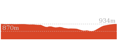
Maps for the Wentworth Falls Station Loop walk
You can download the PDF for this walk to print a map.
These maps below cover the walk and the wider area around the walk, they are worth carrying for safety reasons.
| Katoomba | 1:25 000 Map Series | 89301S KATOOMBA | NSW-89301S |
| Katoomba | 1:100 000 Map Series | 8930 KATOOMBA | 8930 |
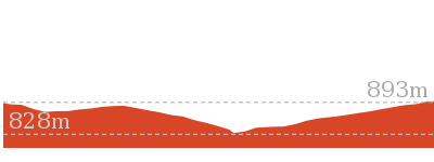
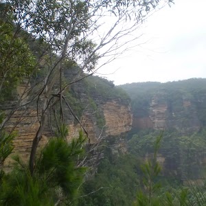
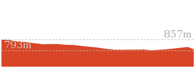
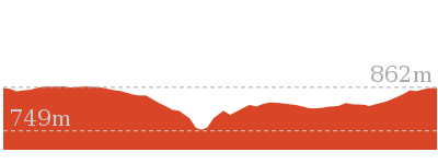
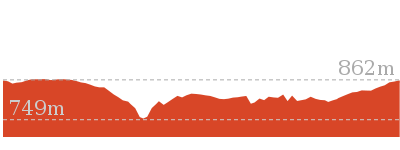
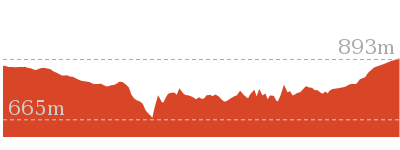
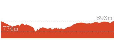
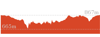
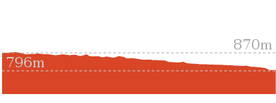
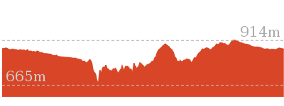
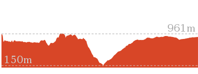
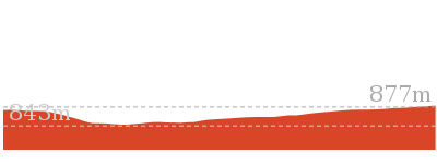
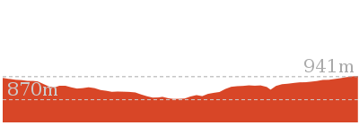
Cross sectional view of the Wentworth Falls Station Loop bushwalking track
Analysis and summary of the altitude variation on the Wentworth Falls Station Loop
Overview of this walks grade – based on the AS 2156.1 – 2001
Under this standard, a walk is graded based on the most difficult section of the walk.
| Length | 9.5 km | ||
| Time | 5 hrs 30 mins | ||
| . | |||
| Grade 4/6 Hard track |
AS 2156.1 | Gradient | Very steep (4/6) |
| Quality of track | Formed track, with some branches and other obstacles (3/6) | ||
| Signs | Directional signs along the way (3/6) | ||
| Experience Required | Some bushwalking experience recommended (3/6) | ||
| Weather | Storms may impact on navigation and safety (3/6) | ||
| Infrastructure | Limited facilities, not all cliffs are fenced (3/6) |
Some more details of this walks Grading
Here is a bit more details explaining grading looking at sections of the walk
Gradient
3.5km of this walk has gentle hills with occasional steps and another 3.2km has short steep hills. Whilst another 2.2km is flat with no steps and the remaining 580m is very steep.
Quality of track
4.2km of this walk follows a smooth and hardened path and another 2.9km follows a clear and well formed track or trail. The remaining (2.4km) follows a formed track, with some branches and other obstacles.
Signs
Around 7km of this walk is clearly signposted, whilst the remaining 2.9km has directional signs at most intersection.
Experience Required
Around 6km of this walk requires no previous bushwalking experience, whilst the remaining 3.4km requires some bushwalking experience.
weather
Around 7km of this walk is not usually affected by severe weather events (that would unexpectedly impact safety and navigation), whilst the remaining 2.7km is affected by storms that may impact your navigation and safety.
Infrastructure
Around 8km of this walk is close to useful facilities (such as fenced cliffs and seats), whilst the remaining 1.3km has limited facilities (such as not all cliffs fenced).
Similar walks
A list of walks that share part of the track with the Wentworth Falls Station Loop walk.
696 m Return
30 mins
Moderate track
762 m Return
30 mins
Moderate track
880 m Return
30 mins
Moderate track
950 m Circuit
30 mins
Moderate track
1.1 km One way
30 mins
Moderate track
1.1 km Return
1 Hr
Hard track
1.3 km Return
1 Hr
Moderate track
1.4 km Circuit
45 mins
Moderate track
1.5 km Return
45 mins
Moderate track
1.5 km Return
1 hr 30 mins
Hard track
1.6 km Return
1 Hr
Moderate track
1.9 km Circuit
1 Hr
Moderate track
3.1 km Circuit
2 hrs
Hard track
3.6 km One way
3 hrs
Hard track
3.8 km Return
4 hrs
Experienced only
4 km Circuit
2 hrs
Moderate track
4.6 km Circuit
3 hrs 30 mins
Hard track
4.8 km Circuit
4 hrs
Hard track
5 km Circuit
4 hrs
Hard track
5.1 km Circuit
4 hrs
Hard track
5.6 km Return
2 hrs
Moderate track
6.7 km Circuit
3 hrs
Hard track
8.6 km Circuit
5 hrs
Hard track
8.9 km Circuit
4 hrs 30 mins
Hard track
9.4 km Circuit
4 hrs
Moderate track
10.2 km Circuit
6 hrs
Hard track
29.2 km One way
2 Days
Experienced only
29.3 km One way
3 Days
Experienced only
Other Nearby walks
A list of walks that start near the Wentworth Falls Station Loop walk.
1.7 km Circuit
1 Hr
Hard track
2.2 km Circuit
1 hr 30 mins
Hard track
2 km Circuit
1 hr 30 mins
Moderate track
1.3 km Circuit
45 mins
Moderate track
926 m Return
45 mins
Hard track
746 m Return
45 mins
Moderate track
1.6 km One way
45 mins
Easy track
2.9 km Return
1 hr 30 mins
Moderate track
538 m Return
30 mins
Moderate track
1.6 km One way
1 Hr
Moderate track
752 m Return
30 mins
Moderate track
1.4 km Circuit
1 Hr
Moderate track
Plan your trip to and from the walk here
The Wentworth Falls Station Loop walk starts and ends at the Wentworth Falls Railway Station (gps: -33.709737, 150.37644)
Your transport options to Wentworth Falls Railway Station are by;
![]() Train. (get details)
Train. (get details)
![]() Bus. (get details)
Bus. (get details)
![]() Car. There is free parking available.
Car. There is free parking available.
(get details)
Short URL = http://wild.tl/wfsl
Gallery images
There are other downloads I am still working on.
You will probably need to login to access these — still all free.
* KML (google earth file)
* GPX (GPS file)
Special Maps/ brochures
* A3 topo maps
* PDF with Lands Topo map base
* PDF with arial image (and map overlay)
I wanted to get the main site live first, this extra stuff will come in time.
Happy walking
Matt 🙂
Wentworth Falls Loop
And Walk
Wentworth Falls Loop

6 hrs
10.2 km Circuit
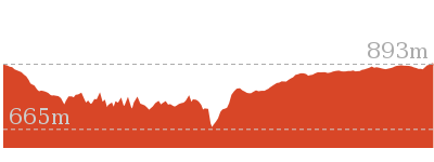
1093 m
Hard track
This is a great walk, both in size and spectacular views. The walk makes its way from Wentworth Falls train station and drops off the plateau, passing the cliffs and waterfalls of the National Pass trail. The track passes many falls, with Empress Falls arguably the most stunning. The walk then heads up to Conservation Hut, a great spot for lunch before continuing along the Over- and Undercliff Tracks back to the train station. An excellent walk.
Closed:


(0km) Wentworth Falls Railway Station → Int of Charles Darwin Track and Page Ave Tracks
690 m
13 mins
17m
-23m
Easy track
From Wentworth Falls Railway Station, this walk exits the station on the western side, on Station St, and turns left to head down to the Great Western Highway past the shops. At the highway, the walk crosses at the lights and turns right, heading down the hill along the foot path. This walk then turns left into Wilson Park soon after the colourful bus stop. The walk follows the footpath through Wilson Park. At the toilet block in the centre of the park, the walk tends slightly more to the left until coming to a large archway entrance to the Charles Darwin Walk, near the tennis courts.
Continue straight: From the south-east corner of Wilson Park (near the tennis courts), this walk heads under the large wooden archway signposted as ‘Charles Darwin Walk’. The walk follows the track passing a blue sign pointing to ‘Wentworth Falls Waterfall’ and soon after crosses the creek on a small wooden bridge. On the other side of the creek the track meanders through the open pine forest. After heading up some steps the track comes to an intersection with a sign pointing back to ‘Wilson Park’ (the steps on the left head up to Page Ave).
Continue straight: From the south-east corner of Wilson Park (near the tennis courts), this walk heads under the large wooden archway signposted as ‘Charles Darwin Walk’. The walk follows the track passing a blue sign pointing to ‘Wentworth Falls Waterfall’ and soon after crosses the creek on a small wooden bridge. On the other side of the creek the track meanders through the open pine forest. After heading up some steps the track comes to an intersection with a sign pointing back to ‘Wilson Park’ (the steps on the left head up to Page Ave).
(0.69km) Int of Charles Darwin Track and Page Ave Tracks → Int of Charles Darwin and Fletcher St Tracks
1.2 km
25 mins
38m
-69m
Easy track
Continue straight: From the intersection, this walk passes the blue sign (on the right) and turns right down the steps to immediately come to an intersection just before the bridge (and a ‘Charles Darwin Walk’ sign).
Turn left: From the intersection, this walk follows ‘Charles Darwin walk’ sign downstream, keeping the creek on the right. The track meanders alongside the creek over some timber platforms and through a lovely Banksia grove. Soon the track heads under a pipe bridge and comes to a clearing and intersection.
Continue straight: From the intersection near the pipe bridge, this walk follow the ‘Wentworth Falls Waterfall’ sign downstream (keeping the creek on the right). The walk soon passes another track (that crosses the creek using a small bridge on the right) and then passes a bush regeneration sign to leave the clearing. The track meanders alongside the creek for a while before heading down some stairs and crossing the creek on a bridge. On the other side the walk passes a bench seat and then comes to an intersection with the signposted ‘Parkes Street’ track (on the right).
From this intersection, this walk heads downstream (keeping the creek to the left). The walk crosses the creek on a foot bridge and follows the creek closely soon passing a beautiful set of cascades.
After cascades, the walk goes down a steep section of stairs and once again crosses the creek. The track continues along a section of boardwalk before joining up with a track that continues beside the creek. This goes along a mixture of boardwalk and bush track until coming to an intersection with a track, with ‘Fletcher St’ and ‘Falls’ signs.
(1.87km) Int of Charles Darwin and Fletcher St Tracks → Weeping Rock waterfall
820 m
14 mins
3m
-26m
Moderate track
Continue straight: From the intersection, this walk follows the creek downstream along a mixture of bush track and boardwalk. The track continues down until crossing two small creeks. Soon after these two small creeks, the track comes to an intersection, with ‘Wentworth Falls’ and ‘National Pass Trail’ signs.
Veer left: From the intersection, this walk heads down the steps following the ‘Weeping Rock Circuit’ sign to the creek a short distance away. Soon the track comes beside Jamison Creek, a lovely flat section of the creek on top of the waterfall. The track continues downstream and across a slippery rockshelf and down a staircase beside the falls. At the bottom of the stairs is another slippery rock platform and a pool at the bottom of Weeping Rock waterfall.
Veer left: From the intersection, this walk heads down the steps following the ‘Weeping Rock Circuit’ sign to the creek a short distance away. Soon the track comes beside Jamison Creek, a lovely flat section of the creek on top of the waterfall. The track continues downstream and across a slippery rockshelf and down a staircase beside the falls. At the bottom of the stairs is another slippery rock platform and a pool at the bottom of Weeping Rock waterfall.
Weeping Rock
Weeping Rock is a waterfall on Jamison Creek, upstream of Wentworth Falls in the Blue Mountains National Park. The water falls over the wide circular top overhang, to then cascade down the rocks to a pool below. A staircase beside the falls helps walkers view this waterfall from different angles. This is a nice cool spot on hot days. The rocks are slippery and there are no fences, care is needed.
(2.69km) Weeping Rock waterfall → Int of Weeping Rock and Wentworth Falls Tracks
40 m
1 mins
0m
-8m
Moderate track
Continue straight: From the bottom of Weeping Rock waterfall, this walk heads downstream (keeping the creek to the left), up some steps and passes another great view of Weeping Rock. After passing between some large rocks, the walk comes to a 3-way intersection, with a sign pointing back to ‘Weeping Rock Circuit’ and ‘Darwins Walk’.
(2.73km) Int of Weeping Rock and Wentworth Falls Tracks → Top of Wentworth Falls
60 m
1 mins
3m
-2m
Moderate track
Turn left: From the intersection, this walk follows the ‘Wentworth Falls’ and ‘Wentworth Pass’ signs down the steps. The track soon comes to a nice view of Jamison Creek, where it continues to wind down the hill and open up at a fenced rock platform at the top of Wentworth Falls. Here the walk crosses Jamison Creek using the stepping stones, to reveal a lovely waterhole and Queen’s Cascades(the creek may be impassable after rain). This is the top of the Wentworth Falls.
Queen’s Cascades
Queen’s Cascades[1] are a lovely set of falls on the Jamison Creek at the top of Wentworth Falls. The creek heads down the wide, two-stage cascades into a sandy pool. From the pool, the water flows between the stepping stones, under the fence and down the very tall Wentworth Falls. There are also great views to Sublime Point across the valley.
(2.79km) Top of Wentworth Falls → Rocket Point Creek Intersection
30 m
1 mins
2m
-6m
Moderate track
Continue straight: From the top of Wentworth Falls, this walk heads away from the falls (keeping the valley view to the right). With the handrail on the right, the track soon crosses a small creek and comes to a three-way intersection and a ‘Rocket Point Circuit’ sign.
Grand Stairway
The Grand Stairway is a very memorable section of the National Pass in the Blue Mountains National Park. The stairway is reported to be ‘the tallest outdoor staircase in Australia’ and was built in the early 1900’s by hand (and dynamite). This stairway, and the rest of the National Pass, was built by a team nicknamed ‘the Irish Brigade’ for the cost of £430 . Today, the Grand Stairway is well-maintained and provides walkers access to the valley below Wentworth Falls.
(2.81km) Rocket Point Creek Intersection → Middle Wentworth Falls
330 m
16 mins
36m
-98m
Hard track
Continue straight: From the intersection, this walk follows the ‘National Pass To Wentworth Pass’ sign along the clear track, keeping the handrail on the right. The track soon comes to the cliff. From here the National Pass heads though a series of sandstone caves and down plenty of stairs, most of which are cut into the stone. The views into the valley and of Wentworth Falls are stunning.
After passing a fairly long rock-shelf at the bottom of the timber stairs (and the square hole in the cliff), this walk heads down a long set of steep stone stairs to come to a fenced ‘No Access Cliff Point’ area. From here, the pass continues down more steep stone stairs until reaching the moister area at the bottom of the cliff. The track continues down the hill along the steps and stepping stones. As the track approaches the creek, it zigzags down to the stone-slab bridges and crosses Jamison Creek. From here, there is a small side track up to the pool, at the bottom of the falls (halfway down the main Wentworth Falls).
After passing a fairly long rock-shelf at the bottom of the timber stairs (and the square hole in the cliff), this walk heads down a long set of steep stone stairs to come to a fenced ‘No Access Cliff Point’ area. From here, the pass continues down more steep stone stairs until reaching the moister area at the bottom of the cliff. The track continues down the hill along the steps and stepping stones. As the track approaches the creek, it zigzags down to the stone-slab bridges and crosses Jamison Creek. From here, there is a small side track up to the pool, at the bottom of the falls (halfway down the main Wentworth Falls).
Middle of Wentworth Falls
The National Pass crosses Wentworth Falls halfway down its long drop. At this crossing, NPWS have installed sandstone block bridges to improve access for walkers. There are a few side tracks that have been used to explore the area – beware of the slippery rocks and unfenced ledges. There is also a great view into the valley from where the water continues to fall on it long journey further into the valley. This is a lovely spot to cool down on a warm day.
(3.14km) Middle Wentworth Falls → Int of Valley of the Waters and National Pass Tracks
1.7 km
1 hr 42 mins
527m
-499m
Moderate track
Continue straight: From pool and creek crossing (halfway up Wentworth Falls), this walk follows the track (keeping the main valley to the left) away from the falls. The track heads across the rock-platform and timber bridge, with the handrail on the left, then up a series of steep stairs. As the track flattens out, it winds around the side of the valley at the base of a large cliff (on the right). Following the stepping stones, the track heads under a low sandstone overhang (be sure to duck) – past this overhang, there are great views back to the waterfall. The track then rounds the corner to the right, coming to an intersection marked with a ‘National Pass’ sign and a sign pointing back to ‘Wentworth Falls’ (at the top of ‘Slack Stairs’).
Continue straight: From the intersection at the top of ‘Slack Stairs’, this walk follows the ‘National Pass – Valley of the Waters’ sign up the few steps, keeping the main valley to the left. The walk soon crosses a creek (and waterfall) using the stepping stones. The walk continues along the cliff-line, up the stairs and along more stepping stones to pass over a couple of smaller creeks. Soon after passing a great vantage point, the walk comes to a handrailed timber platform that passes behind a waterfall from Den Fenella Creek.
From the Den Fenella Creek waterfall, this walk heads along the path, keeping the valley views to the left. After passing a few open ledges with great valley views, the walk heads into another valley and crosses a small creek. The walk continues along the cliff line as it bends right, into the Valley of the Waters, passing a sandstone bench seat and few small creeks. The walk then crosses a timber platform through a sandstone overhang then heads down the stairs to a lovely ferntree valley. From here, the walk continues down the stairs, soon coming to an intersection with Wentworth Pass and a ‘National Pass – Wentworth Falls’ sign pointing back.
(4.86km) Int of Valley of the Waters and National Pass Tracks → Lodore Falls
20 m
1 mins
14m
0m
Moderate track
Veer right: From the intersection, this walk follows the ‘National Pass – Conservation Hut’ sign up the steps, keeping the creek to the left. After heading under the overhang and up the timber steps, the walk crosses the Valley Of the Waters Creek in front of Lodore Falls (using the stepping stones). This creek may be impassable after rain.
Lodore Falls
Lodore Falls are a lovely set of falls on the Valley of the Waters Creek. The narrow falls have a staircase on one side and stepping stones (and handrail) crossing the bottom, making it easier for walkers to appreciate this waterfall from many angles. Just beyond the handrail, the water falls over another cliff, providing a great view down the valley.
(4.88km) Lodore Falls → Empress Falls Crossing
70 m
2 mins
9m
0m
Hard track
Continue straight: From Lodore Falls, this walk heads upstream, up the staircase, keeping the creek on the right. The steps climb to the base of a wider cascade – Sylvia Falls.
From Sylvia Falls, this walk heads up the stairs, keeping the handrail and creek to the right. The path heads up the hill, passing a ‘Track’ sign before coming to a creek crossing in front of the tall Empress Falls.
From Sylvia Falls, this walk heads up the stairs, keeping the handrail and creek to the right. The path heads up the hill, passing a ‘Track’ sign before coming to a creek crossing in front of the tall Empress Falls.
Empress Falls
Empress Falls is a spectacular waterfall in the Valley of the Waters. The Valley of the Water Creek comes out of the slot in the cliff and tumbles down a series of cliffs to a sandy pool. The fall is the site of the last abseil in a popular canyon, making a great site for walkers in the area. Stepping stones help walkers cross below the falls. There is a small overhang next to the falls, giving the area shade and offering a great place to rest.
(4.95km) Empress Falls Crossing → Int of Valley of the Waters and Nature Tracks
90 m
2 mins
14m
-4m
Moderate track
Continue straight: From the bottom of Empress Falls, this walk crosses the creek using the stepping stones, keeping the handrail on the left. On the way up the hill, the walk passes closer to Empress Falls before zigzagging up to a sandstone overhang and timber staircase. At the top of the staircase, the walk crosses Isabel Creek using the stepping stones. The track then winds up the hill, soon coming to an intersection with the ‘Nature Track’ and a sign pointing back to ‘National Pass – Valley of the Waters’. (These creeks may not be passable after rain)
(5.04km) Int of Valley of the Waters and Nature Tracks → Empress Lookout
90 m
4 mins
20m
-12m
Hard track
Turn right: From the intersection, this walk heads up the wooden steps, following the ‘National Pass – Tea Rooms’ sign. The walk soon heads though a long rock overhang to the base of a metal staircase. The walk climbs the series of steep metal staircases zigzagging up the hill. After climbing some wooden steps, the walk comes to the fenced and signposted ‘Empress Lookout’.
Empress Lookout
Empress Lookout is a fenced and signposted lookout, perched on a sandstone overhang above the Valley of the Waters Creek. There is a view down to part of the Empress Falls and into the canyon. The views are filtered through the surrounding trees. It makes for a good spot to catch your breath when walking into, or out of, the Valley of the Waters.
(5.13km) Empress Lookout → Int of Valley of the Waters and Queen Victoria Tracks
60 m
2 mins
18m
0m
Easy track
Turn left: From the Empress Lookout, this walk heads up the wooden steps away from the lookout. The walk heads up the hill, soon passing under a sandstone overhang then up more steps, coming to a ‘Y’ intersection with the signposted ‘Queen Victoria Lookout’ track (on the right).
(5.19km) Int of Valley of the Waters and Queen Victoria Tracks → Queen Victoria Lookout
20 m
1 mins
0m
-17m
Easy track
Turn right: From the intersection, this walk follows the ‘Queen Victoria Lookout’ sign down the steps towards the handrail. Soon the track passes a small lookout on the left and, shortly afterwards, the fence leads to the rock platform and fenced ‘Queen Victoria Lookout’. At the end of this side trip, retrace your steps back to the main walk then Turn right.
Queen Victoria Lookout
The Queen Victoria Lookout is perched above the Valley of the Waters, south-west of Conservation Hut. The fenced lookout has views into the narrow section of the valley. The views are made more dramatic by the roar of the waterfalls below and the mists which frequent the area. Empress Falls are only just visible – the main views extend down Jamison Valley. Kings Tableland (left) and Sublime Point(right) dominate the views and the eastern edge of Mount Solitary and beyond is also visible.
(5.19km) Int of Valley of the Waters and Queen Victoria Tracks → Conservation Hut
320 m
8 mins
75m
-2m
Moderate track
Veer left: From the intersection, this walk heads away from ‘Queen Victoria Lookout’ up the set of stairs to almost immediately come to a ‘Y’ intersection with the unsignposted Lyrebird Cliff track (on the right).
Continue straight: From the intersection, this walk heads up the timber and dirt steps, away from the valley views. The track passes a few faint tracks (on the right, that lead to an unfenced view point). The track soon comes to a signposted intersection with the ‘Overcliff Track’.
Continue straight: From the intersection, this walk follows the ‘National Pass – Tea Rooms’ sign up the steps, with the handrail on the left. After a short time, the track passes a couple of faint tracks (on the right, leading to an old picnic area). Heading up the main steps, the walk passes another handrail (and signs) then an information sign, before coming to a three-way intersection with the ‘Shortcut Track’.
Continue straight: From the intersection, this walk heads up the steps towards the building. The walk passes a couple of picnic shelters (on the right) before coming to the road and the front of the ‘Conservation Hut’.
Continue straight: From the intersection, this walk heads up the timber and dirt steps, away from the valley views. The track passes a few faint tracks (on the right, that lead to an unfenced view point). The track soon comes to a signposted intersection with the ‘Overcliff Track’.
Continue straight: From the intersection, this walk follows the ‘National Pass – Tea Rooms’ sign up the steps, with the handrail on the left. After a short time, the track passes a couple of faint tracks (on the right, leading to an old picnic area). Heading up the main steps, the walk passes another handrail (and signs) then an information sign, before coming to a three-way intersection with the ‘Shortcut Track’.
Continue straight: From the intersection, this walk heads up the steps towards the building. The walk passes a couple of picnic shelters (on the right) before coming to the road and the front of the ‘Conservation Hut’.
Conservation Hut
Conservation Hut is a small cafe perched above the Valley of the Waters, Blue Mountains National Park. The hut was opened in 1963 as a meeting place for the local conservation movement. Rebuilt, Conservation Hut opened as a cafe in 1993, serving breakfast, lunch and dinner, seven days a week. Around the Conservation Hut is a small parking area, public toilets, picnic shelters, town water and B&B’s. For further information or bookings call (02) 4757 3827. More info.
(5.51km) Conservation Hut → Int of Shortcut and Lyrebird Lookout Tracks
290 m
7 mins
11m
-21m
Easy track
Turn around: From Conservation Hut, this walk follows the ‘Valley of the Waters’ sign down some timber and dirt steps passing a couple of picnic shelters. The track soon leads to the signposted intersection with the ‘Short Cut Track’ (still in view of the Conservation Hut).
Turn left : From the intersection, the walk heads along the ‘Short Cut Track’ following the arrow to ‘Wentworth Falls picnic area’. The track gradually heads downhill with small log steps. After a short distance, the walk crosses a small creek using a bridge. The track then bends to the right and continues along till comes to a signposted intersection with another track (on the right).
Turn left : From the intersection, the walk heads along the ‘Short Cut Track’ following the arrow to ‘Wentworth Falls picnic area’. The track gradually heads downhill with small log steps. After a short distance, the walk crosses a small creek using a bridge. The track then bends to the right and continues along till comes to a signposted intersection with another track (on the right).
(5.8km) Int of Shortcut and Lyrebird Lookout Tracks → Breakfast Point Lookout
530 m
11 mins
3m
-56m
Moderate track
Continue straight: From the intersection, the walk follows the sign to ‘Wentworth Falls picnic area’ that heads south-east along the flat bush track. Soon the walk comes to a 4-way intersection marked with signs pointing to Breakfast Pt Lookout, Murphy’s Lane and to the Falls Picnic Area.
Turn right: From the intersection, this walk heads down the gentle hill, following the ‘Breakfast Pt. LO’ sign to the south. The track gradually heads downhill until it turns to the left, where the track becomes slightly steeper. After a short while, the walk turns back to the right and the track becomes rougher, continuing down the hill to Breakfast Point Lookout, and an intersection with the Overcliff Track.
Turn right: From the intersection, this walk heads down the gentle hill, following the ‘Breakfast Pt. LO’ sign to the south. The track gradually heads downhill until it turns to the left, where the track becomes slightly steeper. After a short while, the walk turns back to the right and the track becomes rougher, continuing down the hill to Breakfast Point Lookout, and an intersection with the Overcliff Track.
Breakfast Point Lookout
Breakfast Point Lookout is on the Overcliff Walk, west of Den Fenella Creek. The lookout has a short stone wall and great views across the Jamison Valley. The center piece of the view is out to Mount Solitary and beyond, there are also good views to Kings Tableland (left). This is a good spot to stop and enjoy the sweeping views of the majestic valley.
(6.33km) Breakfast Point Lookout → Int of Overcliff and Denfenella Lookout Track
230 m
12 mins
34m
-74m
Moderate track
Turn left: From Breakfast Point Lookout, this walk follows the old ‘Undercliff walk’ sign east, keeping the main valley view to the right. The track meanders for a little while before heading down some steps (around some large boulders) before coming to an intersection where the walk turns left. (The right-hand track heads down to the Lady Sees lookout with a fence in disrepair, currently closed). About 100m later, the clear track leads down to a signposted intersection with the ‘Den Fenella’ track just before the footbridge.
(6.56km) Int of Overcliff and Den Fenella Lookout Track → Den Fenella Lookout
70 m
4 mins
8m
-51m
Hard track
Turn right: From the intersection, this walk follows the ‘Den Fenella’ sign along the lower track, keeping the creek to the left. The track soon begins to go down very steeply (can be slippery) between the handrails and rock wall. The track then crosses the creek at the stepping stones below the cascades (the creek may be impassable after rain). On the other side of the creek, the walk heads down the steps to come to a bridge below the bigger Den Fenella Fall.
From the Den Fenella Fall, this walk crosses the metal bridge and continues along the cliff edge along the fence-lined track. After heading down some steps, the track ends at a fenced point with great views across the valley. At the end of this side trip, retrace your steps back to the main walk then Veer right.
From the Den Fenella Fall, this walk crosses the metal bridge and continues along the cliff edge along the fence-lined track. After heading down some steps, the track ends at a fenced point with great views across the valley. At the end of this side trip, retrace your steps back to the main walk then Veer right.
Den Fenella Lookout
The Den Fenella Lookout is a small fenced lookout on a cliff ledge, near where Den Fenella Creek falls into the Jamison Valley. The lookout is at the end of the track and has a tall cliff above and below. There is a small tree on the ledge adding to the sense of depth. From here, there are great views to Mount Solitary (middle), Kings Tableland (left), Narrow Neck Plateau (far right) and Sublime Point (right). This is a great spot, well worth a visit.
(6.56km) Int of Overcliff and Denfenella Lookout Track → Int of Undercliff and Princes Rock Tracks
460 m
13 mins
52m
-32m
Moderate track
Veer left: From the intersection, this walk crosses over Den Fenella Creek using the bridge and comes to an intersection with the ‘Undercliff Walk’.
Turn right: From the intersection, this walk follows the ‘Undercliff Walk’ sign, initially following the creek on the right, downstream. The track heads up a small set of steps and then tends left (revealing valley views on the right). Soon after passing a rock wall (on the left), the track goes through a muddy section and continues, passing some more large boulders. Soon the track passes another great rock wall (on the left) with fantastic valley views and an old wire fence. The walk then crosses a small metal bridge and comes to an overhang with a constructed stone wall.
From this overhang, the walk continues around the valley to soon come to a fenced (unnamed) lookout with great views. From the lookout, this walk heads back into the bush, across a small metal bridge and then soon comes to a three-way intersection with ‘Princes Rock’ track on the left (and a sign pointing back to the ‘Valley of the Waters’).
(7.01km) Int of Undercliff and Princes Rock Tracks → Int of Undercliff and Fletchers Lookout Tracks
470 m
22 mins
89m
-104m
Moderate track
Continue straight: From the intersection, the walk follows the ‘Wentworth Falls’ sign along the ‘Undercliff Walk’. The track is initially flat, then soon heads down some steps and passes under a large overhang. After the overhang, the walk heads down some steps, turns left and comes to an intersection (with a track on the right) at the start of another large overhang. (The lower right-hand track heads down to Eagles Nest Lookout.)
From the intersection, this walk heads under the overhang (keeping the rock face on the left). At the other end of the overhang, the track turns left and then passes along another rock wall before coming to a large dead tree and some great valley views.
From this view, keeping the rock face on the left, this walk heads under three significant and low overhangs (be sure to duck), each with wide sweeping right-hand bends. The last overhang has timber blocks on the floor. Soon after the last overhang, the track comes to a four-way intersection, with ‘Fletchers Lookout’ a short distance to the right.
(7.48km) Int of Undercliff and Fletchers Lookout Tracks → Int of Charles Darwin and Weeping Rock Tracks
100 m
3 mins
12m
-2m
Moderate track
Turn left : From the intersection, this walk follows the ‘Wentworth Falls Picnic area’ sign up the steps, away from ‘Fletchers Lookout’. Soon the track comes to a ‘T’ intersection, with a sign pointing back to ‘Wentworth Falls’.
Turn right: From the intersection, this walk follows the ‘Weeping Rock Circuit’ sign down the steps, (with the valley to the right). Soon, the track comes to an intersection with ‘Darwins Track’ (on the left).
Turn right: From the intersection, this walk follows the ‘Weeping Rock Circuit’ sign down the steps, (with the valley to the right). Soon, the track comes to an intersection with ‘Darwins Track’ (on the left).
(7.58km) Int of Charles Darwin and Weeping Rock Tracks → Int of Charles Darwin and Fletcher St Tracks
780 m
13 mins
24m
-3m
Moderate track
Veer left: From the intersection, this walk heads alongside Jamison Creek (creek to the right)following the signs along the Charles Darwin Walk. The track soon crosses two small streamlets and continues up the main creek along a mixture of bush track and boardwalk. This passes a great section of overhanging cliff on the other side of the creek. After this, the track rises slightly before going down to an intersection with a track signposted as the way up to Fletcher St, on the left.
(8.36km) Int of Charles Darwin and Fletcher St Tracks → Int of Charles Darwin and Parkes St Tracks
840 m
17 mins
44m
-22m
Easy track
Continue straight: From the intersection, this walk heads upstream beside the creek. This track goes along a mixture of boardwalk and bush track until continuing on a long section of boardwalk. The walk crosses the creek and goes up a steep set of stairs, then past a beautiful section of creek where the water cascades down the rocks.
Shortly the cascades, the track crosses the creek using a foot bridge and comes to a signposted intersection with ‘Parkes Street’ track (on the left).
From the intersection, this walk follows the clear track upstream (keeping the creek through the bush, on the right). The track bends right passing a bench seat and crossing the creek on a footbridge. On the other side of the bridge the walk climbs the stairs then gently meanders along the side of the creek till coming to a clearing. On the other side of the clearing the walk comes to an intersection just before the pipe bridge.
(9.2km) Int of Charles Darwin and Parkes St Tracks → Wilson Park
540 m
12 mins
33m
-20m
Easy track
Continue straight: From the intersection, this walk follows ‘Village’ sign along the track and under the large pipeline (keeping Jamison Creek on the left). The track meanders alongside the creek over some timber platforms and through a lovely Banksia grove. After a short time the walk passes a ‘Charles Darwin walk’ sign and comes to an intersection with a timber bridge on the left of the track.
Turn right: From the intersection, this walk heads up the stairs (away from the bridge and creek) and turns left. The walk almost immediately comes to an intersection with a set of stairs (heading up to Page Ave on the right) and a sign pointing to ‘Wilson Park’.
Continue straight: From the intersection, this walk follows ‘Wilson Park’ and ‘Village’ signs down some steps and along the track (keeping the creek to the left). The track soon passes a bush regeneration information sign and heads into an open pine forest. The walk then crosses the creek on a small timber bridge and heads up the hill. Soon the track passes under the ‘Charles Darwin Walk’ arch and enters Wilson Park (just next to the tennis courts).
(9.75km) Wilson Park → Wentworth Falls Railway Station
490 m
9 mins
15m
-13m
Very easy
Continue straight: From the the archway in Wilson Park, this walk heads away from the tennis courts, keeping the creek on the right. At the far end of the park, the walk comes to the Great Western Highway and turns right. After about 150m, this walk crosses the highway at the traffic lights and heads up Station St, past the shops and up to Wentworth Falls Railway Station on the right.
Maps for the Wentworth Falls Loop walk
You can download the PDF for this walk to print a map.
These maps below cover the walk and the wider area around the walk, they are worth carrying for safety reasons.
| Katoomba | 1:25 000 Map Series | 89301S KATOOMBA | NSW-89301S |
| Katoomba | 1:100 000 Map Series | 8930 KATOOMBA | 8930 |
Cross sectional view of the Wentworth Falls Loop bushwalking track
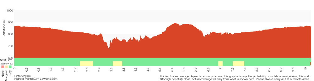
Analysis and summary of the altitude variation on the Wentworth Falls Loop
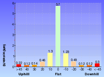
Overview of this walks grade – based on the AS 2156.1 – 2001
Under this standard, a walk is graded based on the most difficult section of the walk.
| Length | 10.2 km | ||
| Time | 6 hrs | ||
| . | |||
| Grade 4/6 Hard track |
AS 2156.1 | Gradient | Very steep (4/6) |
| Quality of track | Formed track, with some branches and other obstacles (3/6) | ||
| Signs | Directional signs along the way (3/6) | ||
| Experience Required | Some bushwalking experience recommended (3/6) | ||
| Weather | Storms may impact on navigation and safety (3/6) | ||
| Infrastructure | Limited facilities, not all cliffs are fenced (3/6) |
Some more details of this walks Grading
Here is a bit more details explaining grading looking at sections of the walk
Gradient
6km of this walk has gentle hills with occasional steps and another 3km has short steep hills. Whilst another 1.1km is flat with no steps and the remaining 490m is very steep.
Quality of track
4.2km of this walk follows a smooth and hardened path and another 3.7km follows a clear and well formed track or trail. The remaining (2.3km) follows a formed track, with some branches and other obstacles.
Signs
Around 6km of this walk is clearly signposted, whilst the remaining 3.9km has directional signs at most intersection.
Experience Required
Around 7km of this walk requires no previous bushwalking experience, whilst the remaining 3km requires some bushwalking experience.
weather
Around 8km of this walk is not usually affected by severe weather events (that would unexpectedly impact safety and navigation), whilst the remaining 2.4km is affected by storms that may impact your navigation and safety.
Infrastructure
Around 9km of this walk is close to useful facilities (such as fenced cliffs and seats), whilst the remaining 1.5km has limited facilities (such as not all cliffs fenced).
Similar walks
A list of walks that share part of the track with the Wentworth Falls Loop walk.
696 m Return
30 mins
Moderate track
762 m Return
30 mins
Moderate track
926 m Return
45 mins
Hard track
950 m Circuit
30 mins
Moderate track
1.1 km One way
30 mins
Moderate track
1.1 km Return
1 Hr
Hard track
1.3 km Circuit
45 mins
Moderate track
1.3 km Return
1 Hr
Moderate track
1.4 km Circuit
45 mins
Moderate track
1.5 km Return
45 mins
Moderate track
1.5 km Return
1 hr 30 mins
Hard track
1.7 km Circuit
1 Hr
Hard track
1.9 km Circuit
1 Hr
Moderate track
2 km Circuit
1 hr 30 mins
Moderate track
2.2 km Circuit
1 hr 30 mins
Hard track
3.1 km Circuit
2 hrs
Hard track
3.6 km One way
3 hrs
Hard track
3.8 km Return
4 hrs
Experienced only
4 km Circuit
2 hrs
Moderate track
4.6 km Circuit
3 hrs 30 mins
Hard track
4.8 km Circuit
4 hrs
Hard track
5 km Circuit
4 hrs
Hard track
5.1 km Circuit
4 hrs
Hard track
5.6 km Return
2 hrs
Moderate track
6.7 km Circuit
3 hrs
Hard track
8.6 km Circuit
5 hrs
Hard track
8.9 km Circuit
4 hrs 30 mins
Hard track
9.4 km Circuit
4 hrs
Moderate track
9.5 km Circuit
5 hrs 30 mins
Hard track
29.2 km One way
2 Days
Experienced only
29.3 km One way
3 Days
Experienced only
Other Nearby walks
A list of walks that start near the Wentworth Falls Loop walk.
880 m Return
30 mins
Moderate track
1.6 km Return
1 Hr
Moderate track
746 m Return
45 mins
Moderate track
1.6 km One way
45 mins
Easy track
2.9 km Return
1 hr 30 mins
Moderate track
538 m Return
30 mins
Moderate track
1.6 km One way
1 Hr
Moderate track
752 m Return
30 mins
Moderate track
1.4 km Circuit
1 Hr
Moderate track
600 m Return
30 mins
Moderate track
844 m Circuit
30 mins
Moderate track
Plan your trip to and from the walk here
The Wentworth Falls Loop walk starts and ends at the Wentworth Falls Railway Station (gps: -33.709737, 150.37644)
Your transport options to Wentworth Falls Railway Station are by;
![]() Train. (get details)
Train. (get details)
![]() Bus. (get details)
Bus. (get details)
![]() Car. There is free parking available.
Car. There is free parking available.
(get details)
Short URL = http://wild.tl/wfl
Gallery images
There are other downloads I am still working on.
You will probably need to login to access these — still all free.
* KML (google earth file)
* GPX (GPS file)
Special Maps/ brochures
* A3 topo maps
* PDF with Lands Topo map base
* PDF with arial image (and map overlay)
I wanted to get the main site live first, this extra stuff will come in time.
Happy walking
Matt 🙂
Wentworth Falls Conservation Hut Loop

3 hrs
6.7 km Circuit
341 m
Hard track


(0km) Wentworth Falls Railway Station → Wilson Park
490 m
9 mins
13m
-15m
Very easy
From Wentworth Falls Railway Station, this walk exits the station on the western side, on Station St, and turns left to head down to the Great Western Highway past the shops. At the highway, the walk crosses at the lights and turns right, heading down the hill along the foot path. This walk then turns left into Wilson Park soon after the colourful bus stop. The walk follows the footpath through Wilson Park. At the toilet block in the centre of the park, the walk tends slightly more to the left until coming to a large archway entrance to the Charles Darwin Walk, near the tennis courts.
(0.49km) Wilson Park → Corner of Armstrong St and Valley Rd
1.2 km
21 mins
55m
-3m
Easy track
Turn right: From the intersection, this walk heads towards the road with the tennis courts on the left, and then heads to the left down Falls Rd, along the footpath. This walk then turns right onto Armstrong Rd and follows this to the end.
(1.68km) Corner of Armstrong St and Valley Rd → Conservation Hut
1 km
21 mins
27m
-47m
Moderate track
Continue straight: From the corner of Valley Rd and Armstrong St, Wentworth Falls, the wide clay track heads into the bush from near the telegraph pole. The track heads down the hill, and is rough and rocky in places. The walk soon comes to an intersection with another track on the left, signposted as the way to ‘Conservation Hut’.
Turn left: From the intersection, this walk follows the ‘Conservation Hut 11min’ sign, heading off the main trail. The narrower trail gently meanders until coming to a three-way intersection, marked with a ‘Nature Track Circuit’ sign (and a gate not far up the track to the left).
Continue straight: From the intersection, this walk follows the ‘Nature Track Circuit – Valley of the Waters Picnic Area’ sign south along the wide trail. The trail soon narrows to a single track and passes some informal tracks (on the left). Soon after passing a backyard, the walk heads up some steps, passing a toilet block and coming to the front of the ‘Conservation Hut’.
Conservation Hut
Conservation Hut is a small cafe perched above the Valley of the Waters, Blue Mountains National Park. The hut was opened in 1963 as a meeting place for the local conservation movement. Rebuilt, Conservation Hut opened as a cafe in 1993, serving breakfast, lunch and dinner, seven days a week. Around the Conservation Hut is a small parking area, public toilets, picnic shelters, town water and B&B’s. For further information or bookings call (02) 4757 3827. More info.
(2.73km) Conservation Hut → Int of Valley of the Waters and Queen Victoria Tracks
320 m
8 mins
2m
-75m
Moderate track
Continue straight: From Conservation Hut, this walk follows the ‘Valley of the Waters’ sign down some timber and dirt steps passing a couple of picnic shelters. The track soon leads to the signposted intersection with the ‘Short Cut Track’ (still in view of the Conservation Hut).
Continue straight: From the intersection, this walk follows the ‘Valley of the Waters’ sign down the steps, passing an information sign. After the handrail and more signs, the track passes a couple of faint tracks (on the left, leading to an old picnic area). Further down the steps, the walk comes the end of another handrail and a three-way intersection (signposted ‘Overcliff Track’ and ‘National Pass’).
Continue straight: From the intersection, this walk follows the ‘National Pass – Valley of the Waters’ sign down the timber steps. The track passes a few faint tracks (on the left, that lead to an unfenced view point). The walk continues down the steps, soon coming to an unsignposted intersection with the Lyrebird Cliff track (on a small sandstone rock platform).
Continue straight: From the intersection, this walk heads down the wooden steps to almost immediately come to the signposted intersection with ‘Queen Victoria Lookout’ track.
(3.05km) Int of Valley of the Waters and Queen Victoria Tracks → Queen Victoria Lookout
20 m
1 mins
0m
-17m
Easy track
Turn left: From the intersection, this walk follows the ‘Queen Victoria Lookout’ sign down the steps towards the handrail. Soon the track passes a small lookout on the left and, shortly afterwards, the fence leads to the rock platform and fenced ‘Queen Victoria Lookout’. At the end of this side trip, retrace your steps back to the main walk then Turn left.
Queen Victoria Lookout
The Queen Victoria Lookout is perched above the Valley of the Waters, south-west of Conservation Hut. The fenced lookout has views into the narrow section of the valley. The views are made more dramatic by the roar of the waterfalls below and the mists which frequent the area. Empress Falls are only just visible – the main views extend down Jamison Valley. Kings Tableland (left) and Sublime Point(right) dominate the views and the eastern edge of Mount Solitary and beyond is also visible.
(3.05km) Int of Valley of the Waters and Queen Victoria Tracks → Empress Lookout
60 m
2 mins
0m
-18m
Easy track
Veer right: From the intersection, this walk heads down the steps away from ‘Queen Victoria Lookout’ keeping the rock face to the right. The track soon passes under a sandstone overhang and then down more steps to come to the fenced and signposted ‘Empress Lookout’.
Empress Lookout
Empress Lookout is a fenced and signposted lookout, perched on a sandstone overhang above the Valley of the Waters Creek. There is a view down to part of the Empress Falls and into the canyon. The views are filtered through the surrounding trees. It makes for a good spot to catch your breath when walking into, or out of, the Valley of the Waters.
(3.11km) Empress Lookout → Lillians Glen
520 m
17 mins
54m
-63m
Hard track
Turn right: From Empress Lookout, this walk heads down the wooden steps, keeping the handrail and valley to the left. Soon the walk heads downs a series of steep metal staircases that zigzag down the hill. At the bottom of the staircases, the walk follows the handrail through a long sandstone overhang. The track then heads down some steps to come to an intersection with the ‘Nature Track’ and a sign pointing back to ‘National Pass – Tea Rooms’.
Veer right: From the intersection, this walk follows the ‘Nature Track’ sign down a few steps and over a small wooden bridge, coming to a clearing, picnic table and small waterfall.
From the picnic table, this walk heads up the steps, passing a ‘Welcome to the Nature Track’ information sign (point 1). The track turns right and passes three numbered posts (2,3,4) – After number 3, the track heads down hill. Soon after the handrail starts, the walk comes to an intersection just before Lillian’s Bridge and post number 5.
Continue straight: From post number 5 at Lillian’s Bridge, this walk heads up the stairs away from the handrail, keeping the bridge and valley to the left. The track makes its way around the hill, passing a few handrails before heading down to some stepping stones across the creek. (This is a nice but slippery spot to enjoy, with a small waterfall to the right). After crossing the stepping stones, the track heads over a small rise to come back down and cross the creek again, on another set of stepping stones. This is signposted ‘Lillians Glen’.
Lillian’s Glen
Lillian’s Glen is a moss and fern filled section on the ‘Valley of the Waters’ Creek (where the Nature Track crosses the creek, south of Edinburgh Castle Rock). There are stepping stones to help cross the creek. Lillian’s Glen is a great spot to rest and enjoy the area, especially on warmer days. For the sure-footed, a short clamber upstream to Asmodeus Pool at the bottom of a waterfall, is worthwhile – a very nice spot at the end of a narrow canyon[2].
(3.63km) Lillian’s Glen → Int of Nature and Edinburgh Castle Rock Tracks
380 m
12 mins
86m
-15m
Moderate track
Continue straight: From Lillian’s Glen, this walk heads up the stairs away from the creek, passing the ‘Lillian’s Glen’ sign. The track winds up the hill for some time (passing a handrail) until just after post marker 7, where the track heads through an sandstone overhang to comes to an unfenced view point with great valley views.
From the view point, this walk heads away from the valley views through the sandstone overhang, keeping the rockface to the right. After the cave, the walk heads up the stairs to follows a tall rock wall (on the right) and comes to post marker 8. From the number 8 post, the walk heads up the stairs, as the track flattens it come to a three-way intersection with a ‘Edinburgh Castle Rock’ sign and post 9.
From the view point, this walk heads away from the valley views through the sandstone overhang, keeping the rockface to the right. After the cave, the walk heads up the stairs to follows a tall rock wall (on the right) and comes to post marker 8. From the number 8 post, the walk heads up the stairs, as the track flattens it come to a three-way intersection with a ‘Edinburgh Castle Rock’ sign and post 9.
(4.02km) Int of Nature and Edinburgh Castle Rock Tracks → Edinburgh Castle Rock
10 m
1 mins
2m
-6m
Moderate track
Turn right: From the intersection, this walk heads past the sign saying ‘Edinburgh Castle Rock’ towards the unfenced rock and great views – this is Edinburgh Castle Rock. At the end of this side trip, retrace your steps back to the main walk then Turn right.
Edinburgh Castle Rock
Edinburgh Castle Rock is a signposted, unfenced viewpoint on the Nature Track, in the Blue Mountains National Park. The rock platform has an interesting formation, with an uneven surface of circular lines. From Edinburgh Castle Rock, there is a view left, up the valley towards the houses on the ridge. Looking right, down the Valley of the Waters, it is possible to see the escarpment of Kings Tablelands.
(4.02km) Int of Nature and Edinburgh Castle Rock Tracks → Int of Nature Track and West St Trail
540 m
15 mins
54m
-18m
Moderate track
Veer left: From the intersection, (with Edinburgh Castle Rock on the right), this walk heads up the gentle hill. The track heads through the bush before crossing a gully using a small metal bridge. Climbing out of this gully on the timber steps, the walk then heads up some metal stairs, and then more timber steps to come to a three-way intersection with ‘West Street’ Track and a sign pointing back down the ‘Nature Track’.
Continue straight: From the intersection, this walk follows the ‘Valley of the Waters Picnic Area’ sign up the steps. The track soon flattens out and heads through the bush for a little while until coming to a ‘T’ intersection with the wide West St trail and a ‘Nature Track Circuit’ sign.
Continue straight: From the intersection, this walk follows the ‘Valley of the Waters Picnic Area’ sign up the steps. The track soon flattens out and heads through the bush for a little while until coming to a ‘T’ intersection with the wide West St trail and a ‘Nature Track Circuit’ sign.
(4.55km) Int of Nature Track and West St Servicetrail → Int of Armstrong St Servicetrail and Nature Track
350 m
8 mins
17m
-17m
Easy track
Turn right: From the intersection, this walk follows the ‘Valley of the Waters Picnic Area’ sign along the trail, passing the back of a house (on the left). The track soon narrows and then passes the back of another house with a private track (on the left). The trail starts heading uphill and, about 60m later, comes to a three-way intersection with a ‘Conservation Hut 11min’ sign (marking the track on the right).
(4.9km) Int of Armstrong St Servicetrail and Nature Track → Corner of Armstrong St and Valley Rd
100 m
2 mins
15m
0m
Moderate track
Veer left: From the intersection, the walk heads uphill along the wide clay track. This is rough and rocky. The track soon emerges onto the corner of Armstrong St and Valley Rd, Wentworth Falls.
(5km) Corner of Armstrong St and Valley Rd → Wilson Park
1.2 km
21 mins
3m
-55m
Easy track
Continue straight: From the intersection, this walk heads down Armstrong Rd for some time. The walk then turns left onto Falls Rd to continue up the footpath, with the road to the left. When the tennis courts appear on the right, the walk tends right, into the park. The walk continues into the park to the intersection above the stairs and Jamison Creek pondage.
(6.2km) Wilson Park → Wentworth Falls Railway Station
490 m
9 mins
15m
-13m
Very easy
Turn left : From the the archway in Wilson Park, this walk heads away from the tennis courts, keeping the creek on the right. At the far end of the park, the walk comes to the Great Western Highway and turns right. After about 150m, this walk crosses the highway at the traffic lights and heads up Station St, past the shops and up to Wentworth Falls Railway Station on the right.
Maps for the Wentworth Falls Conservation Hut Loop walk
You can download the PDF for this walk to print a map.
These maps below cover the walk and the wider area around the walk, they are worth carrying for safety reasons.
| Katoomba | 1:25 000 Map Series | 89301S KATOOMBA | NSW-89301S |
| Katoomba | 1:100 000 Map Series | 8930 KATOOMBA | 8930 |
Cross sectional view of the Wentworth Falls Conservation Hut Loop bushwalking track
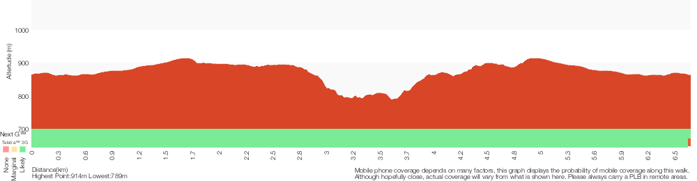
Analysis and summary of the altitude variation on the Wentworth Falls Conservation Hut Loop
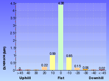
Overview of this walks grade – based on the AS 2156.1 – 2001
Under this standard, a walk is graded based on the most difficult section of the walk.
| Length | 6.7 km | ||
| Time | 3 hrs | ||
| . | |||
| Grade 4/6 Hard track |
AS 2156.1 | Gradient | Very steep (4/6) |
| Quality of track | Formed track, with some branches and other obstacles (3/6) | ||
| Signs | Directional signs along the way (3/6) | ||
| Experience Required | Some bushwalking experience recommended (3/6) | ||
| Weather | Storms may impact on navigation and safety (3/6) | ||
| Infrastructure | Limited facilities, not all cliffs are fenced (3/6) |
Some more details of this walks Grading
Here is a bit more details explaining grading looking at sections of the walk
Gradient
3.4km of this walk is flat with no steps and another 2km has gentle hills with occasional steps. Whilst another 1.3km has short steep hills and the remaining 90m is very steep.
Quality of track
4.9km of this walk follows a smooth and hardened path and another 950m follows a clear and well formed track or trail. The remaining (850m) follows a formed track, with some branches and other obstacles.
Signs
Around 6km of this walk is clearly signposted, whilst the remaining 1km has directional signs at most intersection.
Experience Required
Around 6km of this walk requires no previous bushwalking experience, whilst the remaining 940m requires some bushwalking experience.
weather
Around 6km of this walk is not usually affected by severe weather events (that would unexpectedly impact safety and navigation), whilst the remaining 260m is affected by storms that may impact your navigation and safety.
Infrastructure
Around 4.8km of this walk is close to useful facilities (such as fenced cliffs and seats), whilst the remaining 1.9km has limited facilities (such as not all cliffs fenced).
Similar walks
A list of walks that share part of the track with the Wentworth Falls Conservation Hut Loop walk.
696 m Return
30 mins
Moderate track
762 m Return
30 mins
Moderate track
880 m Return
30 mins
Moderate track
950 m Circuit
30 mins
Moderate track
1.1 km One way
30 mins
Moderate track
1.1 km Return
1 Hr
Hard track
1.5 km Return
1 hr 30 mins
Hard track
1.6 km Return
1 Hr
Moderate track
1.9 km Circuit
1 Hr
Moderate track
3.1 km Circuit
2 hrs
Hard track
3.6 km One way
3 hrs
Hard track
3.8 km Return
4 hrs
Experienced only
4 km Circuit
2 hrs
Moderate track
4.6 km Circuit
3 hrs 30 mins
Hard track
4.8 km Circuit
4 hrs
Hard track
5 km Circuit
4 hrs
Hard track
5.1 km Circuit
4 hrs
Hard track
5.6 km Return
2 hrs
Moderate track
8.6 km Circuit
5 hrs
Hard track
8.9 km Circuit
4 hrs 30 mins
Hard track
9.4 km Circuit
4 hrs
Moderate track
9.5 km Circuit
5 hrs 30 mins
Hard track
10.2 km Circuit
6 hrs
Hard track
29.2 km One way
2 Days
Experienced only
29.3 km One way
3 Days
Experienced only
Other Nearby walks
A list of walks that start near the Wentworth Falls Conservation Hut Loop walk.
1.5 km Return
45 mins
Moderate track
1.4 km Circuit
45 mins
Moderate track
1.3 km Return
1 Hr
Moderate track
1.7 km Circuit
1 Hr
Hard track
2.2 km Circuit
1 hr 30 mins
Hard track
2 km Circuit
1 hr 30 mins
Moderate track
1.3 km Circuit
45 mins
Moderate track
926 m Return
45 mins
Hard track
746 m Return
45 mins
Moderate track
1.6 km One way
45 mins
Easy track
2.9 km Return
1 hr 30 mins
Moderate track
538 m Return
30 mins
Moderate track
Plan your trip to and from the walk here
The Wentworth Falls Conservation Hut Loop walk starts and ends at the Wentworth Falls Railway Station (gps: -33.709737, 150.37644)
Your transport options to Wentworth Falls Railway Station are by;
![]() Train. (get details)
Train. (get details)
![]() Bus. (get details)
Bus. (get details)
![]() Car. There is free parking available.
Car. There is free parking available.
(get details)
Short URL = http://wild.tl/wfchl
Gallery images
There are other downloads I am still working on.
You will probably need to login to access these — still all free.
* KML (google earth file)
* GPX (GPS file)
Special Maps/ brochures
* A3 topo maps
* PDF with Lands Topo map base
* PDF with arial image (and map overlay)
I wanted to get the main site live first, this extra stuff will come in time.
Happy walking
Matt 🙂
Wentworth Falls Station Loop (Undercliff Walk)

4 hrs 30 mins
8.9 km Circuit
658 m
Hard track
This walk passes some stunning waterfalls and views into the Jamison Valley, following the cliff edges around Wentworth Falls. The walk also takes in many magnificent highlights away from the cliffs, including Weeping Rocks, Edinburgh Rock, Lillians Glen and Wentworth Falls. This is a great walk, with the option of a lunch stop at the scenic Conservation Hut restaurant.

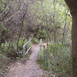
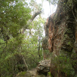
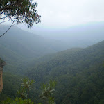


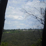
(0km) Wentworth Falls Railway Station → Wilson Park
490 m
9 mins
13m
-15m
Very easy
From Wentworth Falls Railway Station, this walk exits the station on the western side, on Station St, and turns left to head down to the Great Western Highway past the shops. At the highway, the walk crosses at the lights and turns right, heading down the hill along the foot path. This walk then turns left into Wilson Park soon after the colourful bus stop. The walk follows the footpath through Wilson Park. At the toilet block in the centre of the park, the walk tends slightly more to the left until coming to a large archway entrance to the Charles Darwin Walk, near the tennis courts.
(0.49km) Wilson Park → Int of Charles Darwin and Parkes St Tracks
540 m
12 mins
20m
-33m
Easy track
Continue straight: From the south-east corner of Wilson Park (near the tennis courts), this walk heads under the large wooden archway signposted as ‘Charles Darwin Walk’. The walk follows the track passing a blue sign pointing to ‘Wentworth Falls Waterfall’ and soon after crosses the creek on a small wooden bridge. On the other side of the creek the track meanders through the open pine forest. After heading up some steps the track comes to an intersection with a sign pointing back to ‘Wilson Park’ (the steps on the left head up to Page Ave).
Continue straight: From the intersection, this walk passes the blue sign (on the right) and turns right down the steps to immediately come to an intersection just before the bridge (and a ‘Charles Darwin Walk’ sign).
Turn left: From the intersection, this walk follows ‘Charles Darwin walk’ sign downstream, keeping the creek on the right. The track meanders alongside the creek over some timber platforms and through a lovely Banksia grove. Soon the track heads under a pipe bridge and comes to a clearing and intersection.
Continue straight: From the intersection, this walk passes the blue sign (on the right) and turns right down the steps to immediately come to an intersection just before the bridge (and a ‘Charles Darwin Walk’ sign).
Turn left: From the intersection, this walk follows ‘Charles Darwin walk’ sign downstream, keeping the creek on the right. The track meanders alongside the creek over some timber platforms and through a lovely Banksia grove. Soon the track heads under a pipe bridge and comes to a clearing and intersection.
(1.03km) Int of Charles Darwin and Parkes St Tracks → Int of Charles Darwin and Weeping Rock Tracks
1.6 km
30 mins
25m
-68m
Moderate track
Continue straight: From the intersection near the pipe bridge, this walk follow the ‘Wentworth Falls Waterfall’ sign downstream (keeping the creek on the right). The walk soon passes another track (that crosses the creek using a small bridge on the right) and then passes a bush regeneration sign to leave the clearing. The track meanders alongside the creek for a while before heading down some stairs and crossing the creek on a bridge. On the other side the walk passes a bench seat and then comes to an intersection with the signposted ‘Parkes Street’ track (on the right).
From this intersection, this walk heads downstream (keeping the creek to the left). The walk crosses the creek on a foot bridge and follows the creek closely soon passing a beautiful set of cascades.
After cascades, the walk goes down a steep section of stairs and once again crosses the creek. The track continues along a section of boardwalk before joining up with a track that continues beside the creek. This goes along a mixture of boardwalk and bush track until coming to an intersection with a track, with ‘Fletcher St’ and ‘Falls’ signs.
Continue straight: From the intersection, this walk follows the creek downstream along a mixture of bush track and boardwalk. The track continues down until crossing two small creeks. Soon after these two small creeks, the track comes to an intersection, with ‘Wentworth Falls’ and ‘National Pass Trail’ signs.
(2.65km) Int of Charles Darwin and Weeping Rock Tracks → Int of Undercliff and Fletchers Lookout Tracks
100 m
3 mins
2m
-12m
Moderate track
Veer right: From the intersection, this walk heads up the steps following the ‘Wentworth Falls Picnic Area’ sign (keeping the valley to the left). Soon, the track comes to an intersection with a sign pointing back to ‘Weeping Rock Circuit’.
Turn left: From the intersection, this walk follows the ‘Wentworth Falls’ sign down the track. The track soon steepens, heading down the steps and then coming to a four-way intersection, opposite a short track to ‘Fletchers Lookout’.
Turn left: From the intersection, this walk follows the ‘Wentworth Falls’ sign down the track. The track soon steepens, heading down the steps and then coming to a four-way intersection, opposite a short track to ‘Fletchers Lookout’.
(2.75km) Int of Undercliff and Fletchers Lookout Tracks → Fletchers Lookout
20 m
1 mins
0m
-7m
Moderate track
Continue straight: From the intersection, this walk follows the ‘Fletcher Lookout’ sign down the steps. The fenced and signposted lookout has three main bays, two on the left (with views of Wentworth Falls) and a third down the steps, looking into the valley. At the end of this side trip, retrace your steps back to the main walk then Turn left.
Fletchers Lookout
Fletchers Lookout is a fenced and signposted lookout off the side of the Undercliff Walk, just north of the Wentworth Falls. The lookout provides a fairly close view of the top of Wentworth Falls and a great view into the Jamison Valley. There is a good distant view of Mount Solitary and Narrow Neck, and also great views of the surrounding escarpments.
(2.75km) Int of Undercliff and Fletchers Lookout Tracks → Int of Undercliff and Princes Rock Tracks
470 m
22 mins
104m
-89m
Moderate track
Turn right: From the intersection, this walk follows the ‘Undercliff walk’ sign, keeping the main valley to the left. The track soon passes under three significant and low overhangs (be sure to duck) each with wide sweeping left-hand bends. The first overhang has timber blocks on the floor. Soon after the third overhang, the track comes to a point with a large dead tree and some great valley views.
From the view, this walk keeps the rock wall on the right and soon turns right, passing through a large overhang. On the other end of this overhang, the track comes to an unsignposted ‘Y’ intersection. (The lower left-hand track heads down to Eagles Nest Lookout.)
From the intersection, this walk follows the higher track (keeping the valley view to the left). The track soon bends right, heads up some steps and passes under a large overhang. Soon after this overhang, the walk heads up some steps then comes to a three-way intersection with the ‘Princes Rock’ track (on the right) and a ‘Wentworth Falls’ sign pointing back.
From the view, this walk keeps the rock wall on the right and soon turns right, passing through a large overhang. On the other end of this overhang, the track comes to an unsignposted ‘Y’ intersection. (The lower left-hand track heads down to Eagles Nest Lookout.)
From the intersection, this walk follows the higher track (keeping the valley view to the left). The track soon bends right, heads up some steps and passes under a large overhang. Soon after this overhang, the walk heads up some steps then comes to a three-way intersection with the ‘Princes Rock’ track (on the right) and a ‘Wentworth Falls’ sign pointing back.
(3.22km) Int of Undercliff and Princes Rock Track → Princes Rock
110 m
3 mins
8m
-10m
Moderate track
Turn right: From the intersection, this walk follows the ‘Princes Rock’ sign up the steps, away from the Undercliff Walk. This track climbs up, passing by a great fenced view over to Mt Solitary and the valley to the right. Soon, the walk comes to an intersection, with a sign pointing back to the ‘Undercliff Track 100m’.
Turn right: From the intersection, this walk heads downhill following the ‘Princes Rock Lookout 200m’ sign along the wide track. Very soon, the walk comes to an intersection with another track (on the left – which was closed at time of writing).
Continue straight: From the intersection, the walk heads down the gentle hill towards the cliffs and the fenced (unsignposted) Princes Rock Lookout. At the end of this side trip, retrace your steps back to the main walk then Turn sharp right.
Princes Rock
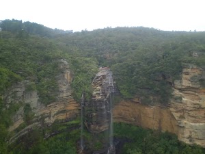
Princes Rock is a great fenced lookout, to the west of Wentworth Falls. There are extensive views into the Jamison Valley below. The lookout has an excellent view of Wentworth Falls, cascading over the cliffs opposite.
(3.22km) Int of Undercliff and Princes Rock Tracks → Int of Den Fenella and Undercliff Tracks
440 m
13 mins
32m
-46m
Moderate track
Continue straight: From the intersection, this walk follows the ‘Valley of the Waters’ sign along the track (with filtered views into the valley on the left). The walk soon crosses a small metal bridge and comes to a fenced (unnamed) lookout with great valley views. The walk follows the track back into the bush as it heads around the valley, soon coming to a sandstone overhang with a constructed stone wall, and more great valley views.
From the overhang, the walk continues around the cliff wall, down the metal steps and along the base of the cliff. After passing an interesting rock formation, the track heads through a muddy section then soon bends right. The walk then heads down some steps and soon comes to an intersection just before a footbridge, with a sign pointing back to the ‘Undercliff Walk’.
From the overhang, the walk continues around the cliff wall, down the metal steps and along the base of the cliff. After passing an interesting rock formation, the track heads through a muddy section then soon bends right. The walk then heads down some steps and soon comes to an intersection just before a footbridge, with a sign pointing back to the ‘Undercliff Walk’.
(3.66km) Int of Den Fenella and Undercliff Tracks → Int of Overcliff and Denfenella Lookout Track
10 m
0m
-6m
Very easy
Turn left: From the intersection, this walk crosses over Den Fenella Creek using the bridge and comes to an intersection at the ‘Den Fenella’ sign.
(3.67km) Int of Overcliff and Den Fenella Lookout Track → Den Fenella Lookout
70 m
4 mins
8m
-51m
Hard track
Veer left: From the intersection, this walk follows the ‘Den Fenella’ sign along the lower track, keeping the creek to the left. The track soon begins to go down very steeply (can be slippery) between the handrails and rock wall. The track then crosses the creek at the stepping stones below the cascades (the creek may be impassable after rain). On the other side of the creek, the walk heads down the steps to come to a bridge below the bigger Den Fenella Fall.
From the Den Fenella Fall, this walk crosses the metal bridge and continues along the cliff edge along the fence-lined track. After heading down some steps, the track ends at a fenced point with great views across the valley. At the end of this side trip, retrace your steps back to the main walk then Turn left.
From the Den Fenella Fall, this walk crosses the metal bridge and continues along the cliff edge along the fence-lined track. After heading down some steps, the track ends at a fenced point with great views across the valley. At the end of this side trip, retrace your steps back to the main walk then Turn left.
Den Fenella Lookout
The Den Fenella Lookout is a small fenced lookout on a cliff ledge, near where Den Fenella Creek falls into the Jamison Valley. The lookout is at the end of the track and has a tall cliff above and below. There is a small tree on the ledge adding to the sense of depth. From here, there are great views to Mount Solitary (middle), Kings Tableland (left), Narrow Neck Plateau (far right) and Sublime Point (right). This is a great spot, well worth a visit.
(3.67km) Int of Overcliff and Denfenella Lookout Track → Breakfast Point Lookout
230 m
12 mins
74m
-34m
Moderate track
Veer right: From the intersection, this walk heads away from the bridge following the higher track. After about 100m, the track turns right at the next intersection. (The left-hand track heads down to the Lady Sees lookout with a fence in disrepair, currently closed). Soon this walk heads up some steps (around some large boulders) before meandering through the bush for some time. After a little while, the track comes to a three-way intersection and the unsignposted Breakfast Point Lookout.
Breakfast Point Lookout
Breakfast Point Lookout is on the Overcliff Walk, west of Den Fenella Creek. The lookout has a short stone wall and great views across the Jamison Valley. The center piece of the view is out to Mount Solitary and beyond, there are also good views to Kings Tableland (left). This is a good spot to stop and enjoy the sweeping views of the majestic valley.
(3.9km) Breakfast Point Lookout → Lyrebird Lookout
640 m
21 mins
75m
-78m
Moderate track
Continue straight: From Breakfast Point Lookout, this walk follows the Overcliff Track west, keeping the valley views to the left. The track soon passes an informal track (on the left) before heading along the base of a large rock wall (on the right). The track then heads up the steps following the handrail – soon after the end of the handrail, the track passes another informal track (on the left). After passing an often muddy section of track, this walk turns left at the intersection, then heads a few meters to the fenced and signposted ‘Lyrebird Lookout’.
Lyrebird Lookout
Lyrebird Lookout is a fenced and signposted lookout on the Overcliff Walk, south of the Conservation Hut in the Blue Mountains National Park. The lookout hosts a great view of Sublime Point (right) and Mount Solitary (centre). A welcome gap in the trees reveals this great view.
(4.54km) Lyrebird Lookout → Int of Lyrebird Cliff Track and Overcliff Tracks
60 m
2 mins
11m
0m
Moderate track
Continue straight: From Lyrebird Lookout, this walk keeps the green fence to the left and follows the track into the bush (with the valley behind and to the left). The walk crosses a section that is normally wet and muddy, and soon comes to a unsignposted ‘Y’ intersection with the Lyrebird Cliff Track on the left.
(4.6km) Int of Lyrebird Cliff Track and Overcliff Tracks → Conservation Hut
370 m
9 mins
56m
-3m
Moderate track
Continue straight: From the intersection, this walk takes the upper track and heads north-west. This goes up slightly before flattening out and continuing away from the cliffs, until coming to an intersection with a well-managed track, signposted as the Overcliff Track
Turn right: From the intersection, this walk follows the ‘National Pass – Tea Rooms’ sign up the steps, with the handrail on the left. After a short time, the track passes a couple of faint tracks (on the right, leading to an old picnic area). Heading up the main steps, the walk passes another handrail (and signs) then an information sign, before coming to a three-way intersection with the ‘Shortcut Track’.
Continue straight: From the intersection, this walk heads up the steps towards the building. The walk passes a couple of picnic shelters (on the right) before coming to the road and the front of the ‘Conservation Hut’.
Conservation Hut
Conservation Hut is a small cafe perched above the Valley of the Waters, Blue Mountains National Park. The hut was opened in 1963 as a meeting place for the local conservation movement. Rebuilt, Conservation Hut opened as a cafe in 1993, serving breakfast, lunch and dinner, seven days a week. Around the Conservation Hut is a small parking area, public toilets, picnic shelters, town water and B&B’s. For further information or bookings call (02) 4757 3827. More info.
(4.97km) Conservation Hut → Int of Valley of the Waters Track and Shortcut Track
40 m
1 mins
0m
-6m
Easy track
Turn around: From Conservation Hut, this walk follows the ‘Valley of the Waters’ sign down some timber and dirt steps passing a couple of picnic shelters. The track soon leads to the signposted intersection with the ‘Short Cut Track’ (still in view of the Conservation Hut).
(5.01km) Int of Valley of the Waters Track and Shortcut Track → Int of Valley of the Waters and Queen Victoria Tracks
290 m
7 mins
2m
-69m
Moderate track
Continue straight: From the intersection, this walk follows the ‘Valley of the Waters’ sign down the steps, passing an information sign. After the handrail and more signs, the track passes a couple of faint tracks (on the left, leading to an old picnic area). Further down the steps, the walk comes the end of another handrail and a three-way intersection (signposted ‘Overcliff Track’ and ‘National Pass’).
Continue straight: From the intersection, this walk follows the ‘National Pass – Valley of the Waters’ sign down the timber steps. The track passes a few faint tracks (on the left, that lead to an unfenced view point). The walk continues down the steps, soon coming to an unsignposted intersection with the Lyrebird Cliff track (on a small sandstone rock platform).
Continue straight: From the intersection, this walk heads down the wooden steps to almost immediately come to the signposted intersection with ‘Queen Victoria Lookout’ track.
(5.29km) Int of Valley of the Waters and Queen Victoria Tracks → Queen Victoria Lookout
20 m
1 mins
0m
-17m
Easy track
Turn left: From the intersection, this walk follows the ‘Queen Victoria Lookout’ sign down the steps towards the handrail. Soon the track passes a small lookout on the left and, shortly afterwards, the fence leads to the rock platform and fenced ‘Queen Victoria Lookout’. At the end of this side trip, retrace your steps back to the main walk then Turn sharp left.
Queen Victoria Lookout
The Queen Victoria Lookout is perched above the Valley of the Waters, south-west of Conservation Hut. The fenced lookout has views into the narrow section of the valley. The views are made more dramatic by the roar of the waterfalls below and the mists which frequent the area. Empress Falls are only just visible – the main views extend down Jamison Valley. Kings Tableland (left) and Sublime Point(right) dominate the views and the eastern edge of Mount Solitary and beyond is also visible.
(5.29km) Int of Valley of the Waters and Queen Victoria Tracks → Empress Lookout
60 m
2 mins
0m
-18m
Easy track
Veer right: From the intersection, this walk heads down the steps away from ‘Queen Victoria Lookout’ keeping the rock face to the right. The track soon passes under a sandstone overhang and then down more steps to come to the fenced and signposted ‘Empress Lookout’.
Empress Lookout
Empress Lookout is a fenced and signposted lookout, perched on a sandstone overhang above the Valley of the Waters Creek. There is a view down to part of the Empress Falls and into the canyon. The views are filtered through the surrounding trees. It makes for a good spot to catch your breath when walking into, or out of, the Valley of the Waters.
(5.35km) Empress Lookout → Lillian’s Bridge
260 m
10 mins
42m
-39m
Hard track
Turn right: From Empress Lookout, this walk heads down the wooden steps, keeping the handrail and valley to the left. Soon the walk heads downs a series of steep metal staircases that zigzag down the hill. At the bottom of the staircases, the walk follows the handrail through a long sandstone overhang. The track then heads down some steps to come to an intersection with the ‘Nature Track’ and a sign pointing back to ‘National Pass – Tea Rooms’.
Veer right: From the intersection, this walk follows the ‘Nature Track’ sign down a few steps and over a small wooden bridge, coming to a clearing, picnic table and small waterfall.
From the picnic table, this walk heads up the steps, passing a ‘Welcome to the Nature Track’ information sign (point 1). The track turns right and passes three numbered posts (2,3,4) – After number 3, the track heads down hill. Soon after the handrail starts, the walk comes to an intersection just before Lillian’s Bridge and post number 5.
(5.61km) Lillian’s Bridge → Lillians Glen
260 m
7 mins
12m
-24m
Moderate track
Continue straight: From post number 5 at Lillian’s Bridge, this walk heads up the stairs away from the handrail, keeping the bridge and valley to the left. The track makes its way around the hill, passing a few handrails before heading down to some stepping stones across the creek. (This is a nice but slippery spot to enjoy, with a small waterfall to the right). After crossing the stepping stones, the track heads over a small rise to come back down and cross the creek again, on another set of stepping stones. This is signposted ‘Lillians Glen’.
Lillian’s Glen
Lillian’s Glen is a moss and fern filled section on the ‘Valley of the Waters’ Creek (where the Nature Track crosses the creek, south of Edinburgh Castle Rock). There are stepping stones to help cross the creek. Lillian’s Glen is a great spot to rest and enjoy the area, especially on warmer days. For the sure-footed, a short clamber upstream to Asmodeus Pool at the bottom of a waterfall, is worthwhile – a very nice spot at the end of a narrow canyon[2].
(5.87km) Lillian’s Glen → Int of Nature and Edinburgh Castle Rock Tracks
380 m
12 mins
86m
-15m
Moderate track
Continue straight: From Lillian’s Glen, this walk heads up the stairs away from the creek, passing the ‘Lillian’s Glen’ sign. The track winds up the hill for some time (passing a handrail) until just after post marker 7, where the track heads through an sandstone overhang to comes to an unfenced view point with great valley views.
From the view point, this walk heads away from the valley views through the sandstone overhang, keeping the rockface to the right. After the cave, the walk heads up the stairs to follows a tall rock wall (on the right) and comes to post marker 8. From the number 8 post, the walk heads up the stairs, as the track flattens it come to a three-way intersection with a ‘Edinburgh Castle Rock’ sign and post 9.
From the view point, this walk heads away from the valley views through the sandstone overhang, keeping the rockface to the right. After the cave, the walk heads up the stairs to follows a tall rock wall (on the right) and comes to post marker 8. From the number 8 post, the walk heads up the stairs, as the track flattens it come to a three-way intersection with a ‘Edinburgh Castle Rock’ sign and post 9.
(6.26km) Int of Nature and Edinburgh Castle Rock Tracks → Edinburgh Castle Rock
10 m
1 mins
2m
-6m
Moderate track
Turn right: From the intersection, this walk heads past the sign saying ‘Edinburgh Castle Rock’ towards the unfenced rock and great views – this is Edinburgh Castle Rock. At the end of this side trip, retrace your steps back to the main walk then Turn right.
Edinburgh Castle Rock
Edinburgh Castle Rock is a signposted, unfenced viewpoint on the Nature Track, in the Blue Mountains National Park. The rock platform has an interesting formation, with an uneven surface of circular lines. From Edinburgh Castle Rock, there is a view left, up the valley towards the houses on the ridge. Looking right, down the Valley of the Waters, it is possible to see the escarpment of Kings Tablelands.
(6.26km) Int of Nature and Edinburgh Castle Rock Tracks → Int of Nature Track and West St Trail
540 m
15 mins
54m
-18m
Moderate track
Veer left: From the intersection, (with Edinburgh Castle Rock on the right), this walk heads up the gentle hill. The track heads through the bush before crossing a gully using a small metal bridge. Climbing out of this gully on the timber steps, the walk then heads up some metal stairs, and then more timber steps to come to a three-way intersection with ‘West Street’ Track and a sign pointing back down the ‘Nature Track’.
Continue straight: From the intersection, this walk follows the ‘Valley of the Waters Picnic Area’ sign up the steps. The track soon flattens out and heads through the bush for a little while until coming to a ‘T’ intersection with the wide West St trail and a ‘Nature Track Circuit’ sign.
Continue straight: From the intersection, this walk follows the ‘Valley of the Waters Picnic Area’ sign up the steps. The track soon flattens out and heads through the bush for a little while until coming to a ‘T’ intersection with the wide West St trail and a ‘Nature Track Circuit’ sign.
(6.79km) Int of Nature Track and West St Servicetrail → Int of Armstrong St Servicetrail and Nature Track
350 m
8 mins
17m
-17m
Easy track
Turn right: From the intersection, this walk follows the ‘Valley of the Waters Picnic Area’ sign along the trail, passing the back of a house (on the left). The track soon narrows and then passes the back of another house with a private track (on the left). The trail starts heading uphill and, about 60m later, comes to a three-way intersection with a ‘Conservation Hut 11min’ sign (marking the track on the right).
(7.14km) Int of Armstrong St Servicetrail and Nature Track → Corner of Armstrong St and Valley Rd
100 m
2 mins
15m
0m
Moderate track
Veer left: From the intersection, the walk heads uphill along the wide clay track. This is rough and rocky. The track soon emerges onto the corner of Armstrong St and Valley Rd, Wentworth Falls.
(7.24km) Corner of Armstrong St and Valley Rd → Wilson Park
1.2 km
21 mins
3m
-55m
Easy track
Continue straight: From the intersection, this walk heads down Armstrong Rd for some time. The walk then turns left onto Falls Rd to continue up the footpath, with the road to the left. When the tennis courts appear on the right, the walk tends right, into the park. The walk continues into the park to the intersection above the stairs and Jamison Creek pondage.
(8.44km) Wilson Park → Wentworth Falls Railway Station
490 m
9 mins
15m
-13m
Very easy
Turn left : From the the archway in Wilson Park, this walk heads away from the tennis courts, keeping the creek on the right. At the far end of the park, the walk comes to the Great Western Highway and turns right. After about 150m, this walk crosses the highway at the traffic lights and heads up Station St, past the shops and up to Wentworth Falls Railway Station on the right.
Maps for the Wentworth Falls Station Loop (Undercliff Walk) walk
You can download the PDF for this walk to print a map.
These maps below cover the walk and the wider area around the walk, they are worth carrying for safety reasons.
| Katoomba | 1:25 000 Map Series | 89301S KATOOMBA | NSW-89301S |
| Katoomba | 1:100 000 Map Series | 8930 KATOOMBA | 8930 |
Cross sectional view of the Wentworth Falls Station Loop (Undercliff Walk) bushwalking track
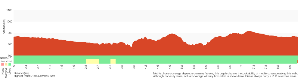
Analysis and summary of the altitude variation on the Wentworth Falls Station Loop (Undercliff Walk)
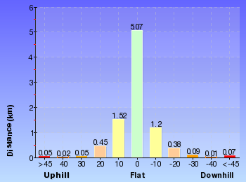
Overview of this walks grade – based on the AS 2156.1 – 2001
Under this standard, a walk is graded based on the most difficult section of the walk.
| Length | 8.9 km | ||
| Time | 4 hrs 30 mins | ||
| . | |||
| Grade 4/6 Hard track |
AS 2156.1 | Gradient | Very steep (4/6) |
| Quality of track | Formed track, with some branches and other obstacles (3/6) | ||
| Signs | Directional signs along the way (3/6) | ||
| Experience Required | Some bushwalking experience recommended (3/6) | ||
| Weather | Storms may impact on navigation and safety (3/6) | ||
| Infrastructure | Limited facilities, not all cliffs are fenced (3/6) |
Some more details of this walks Grading
Here is a bit more details explaining grading looking at sections of the walk
Gradient
4.2km of this walk has gentle hills with occasional steps and another 2.5km has short steep hills. Whilst another 2.2km is flat with no steps and the remaining 90m is very steep.
Quality of track
4.2km of this walk follows a smooth and hardened path and another 2.7km follows a clear and well formed track or trail. The remaining (2.1km) follows a formed track, with some branches and other obstacles.
Signs
Around 7km of this walk is clearly signposted, whilst the remaining 2.2km has directional signs at most intersection.
Experience Required
Around 7km of this walk requires no previous bushwalking experience, whilst the remaining 2km requires some bushwalking experience.
weather
Around 8km of this walk is not usually affected by severe weather events (that would unexpectedly impact safety and navigation), whilst the remaining 900m is affected by storms that may impact your navigation and safety.
Infrastructure
Around 6km of this walk is close to useful facilities (such as fenced cliffs and seats), whilst the remaining 2.8km has limited facilities (such as not all cliffs fenced).
Similar walks
A list of walks that share part of the track with the Wentworth Falls Station Loop (Undercliff Walk) walk.
696 m Return
30 mins
Moderate track
746 m Return
45 mins
Moderate track
762 m Return
30 mins
Moderate track
880 m Return
30 mins
Moderate track
926 m Return
45 mins
Hard track
950 m Circuit
30 mins
Moderate track
1.1 km One way
30 mins
Moderate track
1.1 km Return
1 Hr
Hard track
1.3 km Circuit
45 mins
Moderate track
1.3 km Return
1 Hr
Moderate track
1.4 km Circuit
45 mins
Moderate track
1.5 km Return
45 mins
Moderate track
1.5 km Return
1 hr 30 mins
Hard track
1.6 km Return
1 Hr
Moderate track
1.7 km Circuit
1 Hr
Hard track
1.9 km Circuit
1 Hr
Moderate track
2 km Circuit
1 hr 30 mins
Moderate track
2.2 km Circuit
1 hr 30 mins
Hard track
3.1 km Circuit
2 hrs
Hard track
3.6 km One way
3 hrs
Hard track
3.8 km Return
4 hrs
Experienced only
4 km Circuit
2 hrs
Moderate track
4.6 km Circuit
3 hrs 30 mins
Hard track
4.8 km Circuit
4 hrs
Hard track
5 km Circuit
4 hrs
Hard track
5.1 km Circuit
4 hrs
Hard track
5.6 km Return
2 hrs
Moderate track
6.7 km Circuit
3 hrs
Hard track
8.6 km Circuit
5 hrs
Hard track
9.4 km Circuit
4 hrs
Moderate track
9.5 km Circuit
5 hrs 30 mins
Hard track
10.2 km Circuit
6 hrs
Hard track
29.2 km One way
2 Days
Experienced only
29.3 km One way
3 Days
Experienced only
Other Nearby walks
A list of walks that start near the Wentworth Falls Station Loop (Undercliff Walk) walk.
1.6 km One way
45 mins
Easy track
2.9 km Return
1 hr 30 mins
Moderate track
538 m Return
30 mins
Moderate track
1.6 km One way
1 Hr
Moderate track
752 m Return
30 mins
Moderate track
1.4 km Circuit
1 Hr
Moderate track
600 m Return
30 mins
Moderate track
844 m Circuit
30 mins
Moderate track
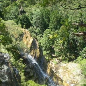
844 m Circuit
30 mins
Moderate track
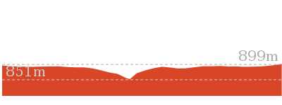
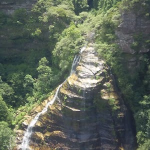
1.8 km One way
1 hr 15 mins
Moderate track
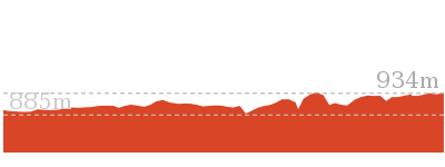
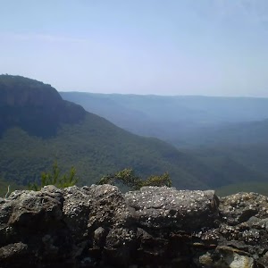
1.5 km Return
1 Hr
Moderate track
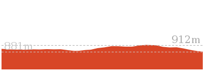
Plan your trip to and from the walk here
The Wentworth Falls Station Loop (Undercliff Walk) walk starts and ends at the Wentworth Falls Railway Station (gps: -33.709737, 150.37644)
Your transport options to Wentworth Falls Railway Station are by;
![]() Train. (get details)
Train. (get details)
![]() Bus. (get details)
Bus. (get details)
![]() Car. There is free parking available.
Car. There is free parking available.
(get details)
![]() Train. (get details)
Train. (get details)
Short URL = http://wild.tl/wfslw
Gallery images
There are other downloads I am still working on.
You will probably need to login to access these — still all free.
* KML (google earth file)
* GPX (GPS file)
Special Maps/ brochures
* A3 topo maps
* PDF with Lands Topo map base
* PDF with arial image (and map overlay)
I wanted to get the main site live first, this extra stuff will come in time.
Happy walking
Matt 🙂
Lillian’s Glen
And Walk
Lillian’s Glen

1 Hr
1.6 km Return
180 m
Moderate track
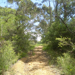


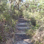
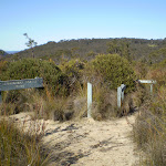
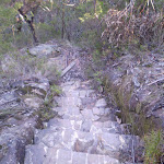

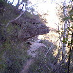
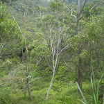
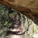
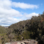

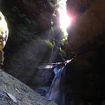

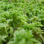

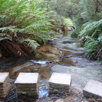


(0km) Corner of West St and Bate St → Int of Nature and Edinburgh Castle Rock Tracks
430 m
11 mins
13m
-66m
Moderate track
From the corner of Bate and West Streets, this walk heads south past the ‘Blue Mountains National Park’ sign and down the wooden steps. This continues down until coming to an intersection, with a sign pointing back up to ‘West St’ (and another ‘Nature Track’ sign).
Turn right: From the intersection, this walk heads down the timber steps, following the ‘Nature Track’ sign. After a short time, the walk heads down some metal stairs, then more timber steps before crossing a gully using a small metal bridge. After climbing out of the gully, the track starts heading gently downhill, coming to a three-way intersection marked with a ‘Edinburgh Castle Rock’ sign.
Turn right: From the intersection, this walk heads down the timber steps, following the ‘Nature Track’ sign. After a short time, the walk heads down some metal stairs, then more timber steps before crossing a gully using a small metal bridge. After climbing out of the gully, the track starts heading gently downhill, coming to a three-way intersection marked with a ‘Edinburgh Castle Rock’ sign.
(0.43km) Int of Nature and Edinburgh Castle Rock Tracks → Edinburgh Castle Rock
10 m
1 mins
2m
-6m
Moderate track
Turn left: From the intersection, this walk heads past the sign saying ‘Edinburgh Castle Rock’ towards the unfenced rock and great views – this is Edinburgh Castle Rock. At the end of this side trip, retrace your steps back to the main walk then Turn left.
Edinburgh Castle Rock
Edinburgh Castle Rock is a signposted, unfenced viewpoint on the Nature Track, in the Blue Mountains National Park. The rock platform has an interesting formation, with an uneven surface of circular lines. From Edinburgh Castle Rock, there is a view left, up the valley towards the houses on the ridge. Looking right, down the Valley of the Waters, it is possible to see the escarpment of Kings Tablelands.
(0.43km) Int of Nature and Edinburgh Castle Rock Tracks → Lillian’s Glen
380 m
12 mins
15m
-86m
Moderate track
Veer right: From the intersection, this walk heads past the two ‘Track’ signs, following the right-hand arrow away from ‘Edinburgh Castle Rock’. The track starts to wind down the steps, which become fairly steep before coming to post 8. From post 8, the walk follows the large rock wall (on the left), then heads down some steps and through a sandstone overhang to come to an unfenced view point, with great valley views.
From the view point, this walk heads through the sandstone overhang, keeping the rockface to the left, passing post number 7. The track starts to head gently down the hill before becoming steeper and winding down the steps. Soon the track comes to a ‘Lillians Glen’ sign, just before a creek crossing.
From the view point, this walk heads through the sandstone overhang, keeping the rockface to the left, passing post number 7. The track starts to head gently down the hill before becoming steeper and winding down the steps. Soon the track comes to a ‘Lillians Glen’ sign, just before a creek crossing.
Lillian’s Glen
Lillian’s Glen is a moss and fern filled section on the ‘Valley of the Waters’ Creek (where the Nature Track crosses the creek, south of Edinburgh Castle Rock). There are stepping stones to help cross the creek. Lillian’s Glen is a great spot to rest and enjoy the area, especially on warmer days. For the sure-footed, a short clamber upstream to Asmodeus Pool at the bottom of a waterfall, is worthwhile – a very nice spot at the end of a narrow canyon[2].
Maps for the Lillian’s Glen walk
You can download the PDF for this walk to print a map.
These maps below cover the walk and the wider area around the walk, they are worth carrying for safety reasons.
| Katoomba | 1:25 000 Map Series | 89301S KATOOMBA | NSW-89301S |
| Katoomba | 1:100 000 Map Series | 8930 KATOOMBA | 8930 |
Cross sectional view of the Lillian’s Glen bushwalking track
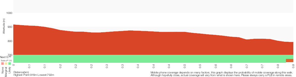
Analysis and summary of the altitude variation on the Lillian’s Glen
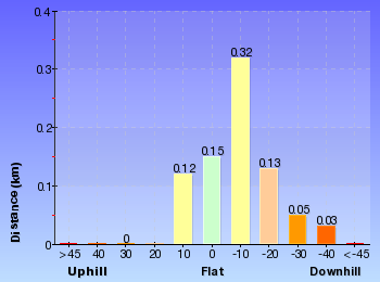
Overview of this walks grade – based on the AS 2156.1 – 2001
Under this standard, a walk is graded based on the most difficult section of the walk.
| Length | 1.6 km | ||
| Time | 1 Hr | ||
| . | |||
| Grade 3/6 Moderate track |
AS 2156.1 | Gradient | Short steep hills (3/6) |
| Quality of track | Formed track, with some branches and other obstacles (3/6) | ||
| Signs | Clearly signposted (1/6) | ||
| Experience Required | Some bushwalking experience recommended (3/6) | ||
| Weather | Weather generally has little impact on safety (1/6) | ||
| Infrastructure | Limited facilities, not all cliffs are fenced (3/6) |
Some more details of this walks Grading
Here is a bit more details explaining grading looking at sections of the walk
Gradient
This whole walk, 810m has short steep hills.
Quality of track
380m of this walk follows a formed track, with some branches and other obstacles and another 240m follows a clear and well formed track or trail. The remaining (190m) follows a smooth and hardened path.
Signs
This whole walk, 810m is clearly signposted.
Experience Required
Around 430m of this walk requires no previous bushwalking experience, whilst the remaining 380m requires some bushwalking experience.
weather
This whole walk, 810m is not usually affected by severe weather events (that would unexpectedly impact safety and navigation).
Infrastructure
Around 430m of this walk is close to useful facilities (such as fenced cliffs and seats), whilst the remaining 380m has limited facilities (such as not all cliffs fenced).
Similar walks
A list of walks that share part of the track with the Lillian’s Glen walk.
880 m Return
30 mins
Moderate track
3.1 km Circuit
2 hrs
Hard track
6.7 km Circuit
3 hrs
Hard track
8.6 km Circuit
5 hrs
Hard track
8.9 km Circuit
4 hrs 30 mins
Hard track
9.5 km Circuit
5 hrs 30 mins
Hard track
Other Nearby walks
A list of walks that start near the Lillian’s Glen walk.
4.8 km Circuit
4 hrs
Hard track
1.9 km Circuit
1 Hr
Moderate track
1.1 km Return
1 Hr
Hard track
762 m Return
30 mins
Moderate track
950 m Circuit
30 mins
Moderate track
4 km Circuit
2 hrs
Moderate track
696 m Return
30 mins
Moderate track
4.6 km Circuit
3 hrs 30 mins
Hard track
1.1 km One way
30 mins
Moderate track
1.5 km Return
1 hr 30 mins
Hard track
3.8 km Return
4 hrs
Experienced only
5.1 km Circuit
4 hrs
Hard track
Plan your trip to and from the walk here
The Lillian’s Glen walk starts and ends at the Corner of West St and Bate St (gps: -33.711986, 150.35767)
Your main transport option to Corner of West St and Bate St is by;
![]() Car. There is free parking available.
Car. There is free parking available.
(get details)
Short URL = http://wild.tl/lg
Gallery images
There are other downloads I am still working on.
You will probably need to login to access these — still all free.
* KML (google earth file)
* GPX (GPS file)
Special Maps/ brochures
* A3 topo maps
* PDF with Lands Topo map base
* PDF with arial image (and map overlay)
I wanted to get the main site live first, this extra stuff will come in time.
Happy walking
Matt 🙂
Wentworth Falls Lookouts Loop
And Walk
Wentworth Falls Lookouts Loop

1 Hr
1.7 km Circuit
191 m
Hard track
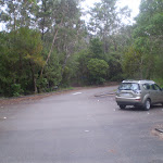
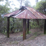
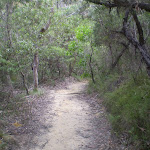

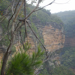
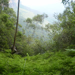
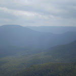

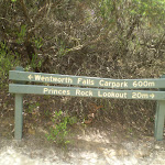
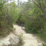
Wentworth Falls Lookout
Wentworth Falls Lookout, in the Blue Mountains National Park, is beside Sir H Burrell Drive. The lookout is fenced and has a large information sign about the area. There are some bench seats and great vistas. There is a view to Wentworth Falls (in the valley to the left), but the most captivating view is across the Jamison Valley to Mount Solitary. There are also great views of the Kings Tableland (left), Sublime Point (right) and Narrow Neck (far right) escarpments. This is a great place to enjoy the scope of this World Heritage listed area.
(0km) Wentworth Falls Lookout → Int of Sir H. Burrell Drive and Princes Rock Track
180 m
5 mins
17m
-13m
Easy track
From Wentworth Falls Lookout (next to Sir H. Burrell Drive), this walk follows the ‘Princes Rock Lookout’ sign down the log stairs. Soon the track passes an old water trough on the right (not suitable for drinking). Soon after this, the track comes to a ‘T’ intersection, with a post pointing back up to ‘Wentworth Falls Lookout’.
Turn right: From the intersection, this walk heads up the steps, following the ‘Car Park’ arrow. The track soon passes a sign pointing back to ‘Princes Rock Lookout’ and comes to the footpath on the side of Sir H. Burrell Drive.
Turn right: From the intersection, this walk heads up the steps, following the ‘Car Park’ arrow. The track soon passes a sign pointing back to ‘Princes Rock Lookout’ and comes to the footpath on the side of Sir H. Burrell Drive.
(0.18km) Int of Sir H. Burrell Drive and Princes Rock Track → Jamison Lookout
140 m
2 mins
1m
-3m
Very easy
Turn left: From the top of the steps, this walk follows the footpath against the flow of traffic, keeping Jamison Valley to the left. Soon the footpath leads past the information sign to the fenced and signposted Jamison Lookout (and great views).
Jamison Lookout

The recently renovated Jamison Lookout is on Sir H Burrell Drive, in the Blue Mountains National Park. The lookout has a wonderful view to the south, down the Jamison Valley to Mount Solitary and beyond. This is a great wheelchair-accessible viewpoint with a large information sign and bench seats. The lookout is fenced, and is located just below the Wentworth Falls Picnic Area.
(0.32km) Jamison Lookout → Int of Den Fenella and Undercliff Tracks
380 m
9 mins
1m
-64m
Moderate track
Continue straight: From Jamison Lookout, this walk follows the footpath, keeping the road and picnic area to the right. The path passes a sign pointing back ‘To walking tracks’ and comes to a small picnic area. The walk heads through this small picnic area to follows the ‘Den Fenella Lookout’ sign down the hill. The track soon starts to zigzag and passes a lookout, with distant views filtered through the surrounding trees (avoid the track to the left near the lookout). As the track continues down, it passes through temperate rainforest and then bends left to travel parallel with Den Fenella Creek. The track soon leads to an intersection just before a bridge, with a sign pointing back up to ‘Wentworth Falls Picnic Area’.
(0.7km) Int of Den Fenella and Undercliff Tracks → Den Fenella Lookout
80 m
4 mins
8m
-57m
Hard track
Turn right: From the intersection, this walk crosses over Den Fenella Creek using the bridge and comes to an intersection at the ‘Den Fenella’ sign.
Veer left: From the intersection, this walk follows the ‘Den Fenella’ sign along the lower track, keeping the creek to the left. The track soon begins to go down very steeply (can be slippery) between the handrails and rock wall. The track then crosses the creek at the stepping stones below the cascades (the creek may be impassable after rain). On the other side of the creek, the walk heads down the steps to come to a bridge below the bigger Den Fenella Fall.
From the Den Fenella Fall, this walk crosses the metal bridge and continues along the cliff edge along the fence-lined track. After heading down some steps, the track ends at a fenced point with great views across the valley.
Den Fenella Lookout
The Den Fenella Lookout is a small fenced lookout on a cliff ledge, near where Den Fenella Creek falls into the Jamison Valley. The lookout is at the end of the track and has a tall cliff above and below. There is a small tree on the ledge adding to the sense of depth. From here, there are great views to Mount Solitary (middle), Kings Tableland (left), Narrow Neck Plateau (far right) and Sublime Point (right). This is a great spot, well worth a visit.
(0.78km) Den Fenella Lookout → Int of Overcliff and Den Fenella Lookout Track
70 m
4 mins
51m
-8m
Hard track
Turn around: From the lookout, this walk heads along the track (keeping the valley views to the right), soon crossing the bridge in front of Den Fenella Fall.
From Den Fenella Falls, this walk heads up the stone-cut steps, crossing the creek above the same falls using the stepping stones (the creek may be impassable after rain). On the other side of the creek, the walk continues up the stairs, passing another cascade. The track soon flattens out and follows the creek, coming to an intersection just before the footbridge and a sign pointing back to ‘Den Fenella’.
From Den Fenella Falls, this walk heads up the stone-cut steps, crossing the creek above the same falls using the stepping stones (the creek may be impassable after rain). On the other side of the creek, the walk continues up the stairs, passing another cascade. The track soon flattens out and follows the creek, coming to an intersection just before the footbridge and a sign pointing back to ‘Den Fenella’.
(0.86km) Int of Overcliff and Denfenella Lookout Track → Int of Den Fenella and Undercliff Tracks
10 m
6m
0m
Very easy
Veer right: From the intersection, this walk crosses over Den Fenella Creek using the bridge and comes to an intersection with the ‘Undercliff Walk’.
(0.87km) Int of Den Fenella and Undercliff Tracks → Princes Rock
560 m
16 mins
54m
-42m
Moderate track
Turn right: From the intersection, this walk follows the ‘Undercliff Walk’ sign, initially following the creek on the right, downstream. The track heads up a small set of steps and then tends left (revealing valley views on the right). Soon after passing a rock wall (on the left), the track goes through a muddy section and continues, passing some more large boulders. Soon the track passes another great rock wall (on the left) with fantastic valley views and an old wire fence. The walk then crosses a small metal bridge and comes to an overhang with a constructed stone wall.
From this overhang, the walk continues around the valley to soon come to a fenced (unnamed) lookout with great views. From the lookout, this walk heads back into the bush, across a small metal bridge and then soon comes to a three-way intersection with ‘Princes Rock’ track on the left (and a sign pointing back to the ‘Valley of the Waters’).
Turn sharp left: From the intersection, this walk follows the ‘Princes Rock’ sign up the steps, away from the Undercliff Walk. This track climbs up, passing by a great fenced view over to Mt Solitary and the valley to the right. Soon, the walk comes to an intersection, with a sign pointing back to the ‘Undercliff Track 100m’.
Turn right: From the intersection, this walk heads downhill following the ‘Princes Rock Lookout 200m’ sign along the wide track. Very soon, the walk comes to an intersection with another track (on the left – which was closed at time of writing).
Continue straight: From the intersection, the walk heads down the gentle hill towards the cliffs and the fenced (unsignposted) Princes Rock Lookout.
Princes Rock
Princes Rock is a great fenced lookout, to the west of Wentworth Falls. There are extensive views into the Jamison Valley below. The lookout has an excellent view of Wentworth Falls, cascading over the cliffs opposite.
(1.42km) Princes Rock → Wentworth Falls Lookout
260 m
9 mins
53m
-6m
Moderate track
Turn around: From the lookout, the walk heads away from the view for a short time to an intersection (with a track on the right – which was closed at time of writing).
Continue straight: From the intersection, this walk heads up the hill along the clear track for a short distance before coming to an intersection, with a sign pointing back to ‘Princes Rock Lookout 200m’.
Continue straight: From the intersection, this walk heads up the steps away from ‘Princes Rock Lookout’. The track soon heads across a large rock platform with steps carved in it and then, following the track back into the bush, the walk passes an old drinking trough (not suitable for drinking). After heading up more log steps, the track comes to a three-way intersection, with a small sign pointing back to ‘Princes Rock Lookout’.
Turn right: From the intersection, this walk follows the ‘Wentworth Falls Lookout’ arrow up the steps as the track bends right. The track soon passes an old water trough on the left (not suitable for drinking). Soon after this, the track comes to Wentworth Falls Lookout (next to Sir H. Burrell Drive).
Maps for the Wentworth Falls Lookouts Loop walk
You can download the PDF for this walk to print a map.
These maps below cover the walk and the wider area around the walk, they are worth carrying for safety reasons.
| Katoomba | 1:25 000 Map Series | 89301S KATOOMBA | NSW-89301S |
| Katoomba | 1:100 000 Map Series | 8930 KATOOMBA | 8930 |
Cross sectional view of the Wentworth Falls Lookouts Loop bushwalking track
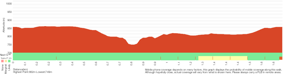
Analysis and summary of the altitude variation on the Wentworth Falls Lookouts Loop
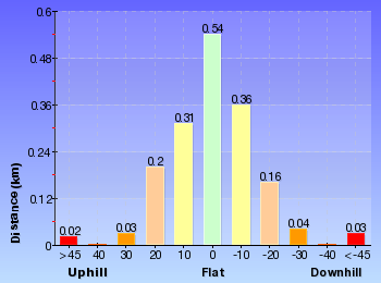
Overview of this walks grade – based on the AS 2156.1 – 2001
Under this standard, a walk is graded based on the most difficult section of the walk.
| Length | 1.7 km | ||
| Time | 1 Hr | ||
| . | |||
| Grade 4/6 Hard track |
AS 2156.1 | Gradient | Very steep (4/6) |
| Quality of track | Formed track, with some branches and other obstacles (3/6) | ||
| Signs | Directional signs along the way (3/6) | ||
| Experience Required | Some bushwalking experience recommended (3/6) | ||
| Weather | Storms may impact on navigation and safety (3/6) | ||
| Infrastructure | Limited facilities (such as cliffs not fenced, significant creeks not bridged) (4/6) |
Some more details of this walks Grading
Here is a bit more details explaining grading looking at sections of the walk
Gradient
1.1km of this walk has short steep hills and another 300m has gentle hills with occasional steps. Whilst another 180m is flat with no steps and the remaining 150m is very steep.
Quality of track
820m of this walk follows a clear and well formed track or trail and another 590m follows a formed track, with some branches and other obstacles. The remaining (270m) follows a smooth and hardened path.
Signs
Around 1.2km of this walk is clearly signposted, whilst the remaining 440m has directional signs at most intersection.
Experience Required
Around 1.2km of this walk requires no previous bushwalking experience, whilst the remaining 530m requires some bushwalking experience.
weather
Around 1.5km of this walk is not usually affected by severe weather events (that would unexpectedly impact safety and navigation), whilst the remaining 150m is affected by storms that may impact your navigation and safety.
Infrastructure
920m of this walk has limited facilities (such as not all cliffs fenced) and another 620m is close to useful facilities (such as fenced cliffs and seats). The remaining (150m) has limited facilities (such as cliffs not fenced, significant creeks not bridged).
Similar walks
A list of walks that share part of the track with the Wentworth Falls Lookouts Loop walk.
746 m Return
45 mins
Moderate track
926 m Return
45 mins
Hard track
1.3 km Circuit
45 mins
Moderate track
2 km Circuit
1 hr 30 mins
Moderate track
2.2 km Circuit
1 hr 30 mins
Hard track
3.6 km One way
3 hrs
Hard track
4 km Circuit
2 hrs
Moderate track
4.6 km Circuit
3 hrs 30 mins
Hard track
5 km Circuit
4 hrs
Hard track
8.9 km Circuit
4 hrs 30 mins
Hard track
9.4 km Circuit
4 hrs
Moderate track
10.2 km Circuit
6 hrs
Hard track
Other Nearby walks
A list of walks that start near the Wentworth Falls Lookouts Loop walk.
1.3 km Return
1 Hr
Moderate track
1.5 km Return
45 mins
Moderate track
1.4 km Circuit
45 mins
Moderate track
3.1 km Circuit
2 hrs
Hard track
4.8 km Circuit
4 hrs
Hard track
1.9 km Circuit
1 Hr
Moderate track
1.1 km Return
1 Hr
Hard track
762 m Return
30 mins
Moderate track
950 m Circuit
30 mins
Moderate track
696 m Return
30 mins
Moderate track
1.1 km One way
30 mins
Moderate track
1.5 km Return
1 hr 30 mins
Hard track
Plan your trip to and from the walk here
The Wentworth Falls Lookouts Loop walk starts and ends at the Wentworth Falls Lookout (gps: -33.72594, 150.372)
Your transport options to Wentworth Falls Lookout are by;
![]() Bus. (get details)
Bus. (get details)
![]() Car. There is free parking available.
Car. There is free parking available.
(get details)
Short URL = http://wild.tl/wfll
Gallery images
There are other downloads I am still working on.
You will probably need to login to access these — still all free.
* KML (google earth file)
* GPX (GPS file)
Special Maps/ brochures
* A3 topo maps
* PDF with Lands Topo map base
* PDF with arial image (and map overlay)
I wanted to get the main site live first, this extra stuff will come in time.
Happy walking
Matt 🙂
Queen Victoria Lookout
And Walk
Queen Victoria Lookout

30 mins
696 m Return
94 m
Moderate track
This walk heads down to the top of the cliffs, overlooking Empress Falls and the lower Valley of the Waters. The track down through the heath is quite nice, although it is nearly all stairs. The view from Queen Victoria Lookout is a stunning one. The noise of the falls can also be heard from the lookout, however the falls themselves cannot been seen from the lookout.


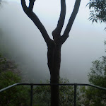
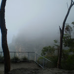
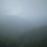
Conservation Hut
Conservation Hut is a small cafe perched above the Valley of the Waters, Blue Mountains National Park. The hut was opened in 1963 as a meeting place for the local conservation movement. Rebuilt, Conservation Hut opened as a cafe in 1993, serving breakfast, lunch and dinner, seven days a week. Around the Conservation Hut is a small parking area, public toilets, picnic shelters, town water and B&B’s. For further information or bookings call (02) 4757 3827. More info.
(0km) Conservation Hut → Int of Valley of the Waters Track and Shortcut Track
40 m
1 mins
0m
-6m
Easy track
From Conservation Hut, this walk follows the ‘Valley of the Waters’ sign down some timber and dirt steps passing a couple of picnic shelters. The track soon leads to the signposted intersection with the ‘Short Cut Track’ (still in view of the Conservation Hut).
(0.04km) Int of Valley of the Waters Track and Shortcut Track → Int of Valley of the Waters and Overcliff Tracks
170 m
4 mins
2m
-27m
Moderate track
Continue straight: From the intersection, this walk follows the ‘Valley of the Waters’ sign down the steps, passing an information sign. After the handrail and more signs, the track passes a couple of faint tracks (on the left, leading to an old picnic area). Further down the steps, the walk comes the end of another handrail and a three-way intersection (signposted ‘Overcliff Track’ and ‘National Pass’).
(0.21km) Int of Valley of the Waters and Overcliff Tracks → Queen Victoria Lookout
140 m
4 mins
0m
-59m
Moderate track
Continue straight: From the intersection, this walk follows the ‘National Pass – Valley of the Waters’ sign down the timber steps. The track passes a few faint tracks (on the left, that lead to an unfenced view point). The walk continues down the steps, soon coming to an unsignposted intersection with the Lyrebird Cliff track (on a small sandstone rock platform).
Continue straight: From the intersection, this walk heads down the wooden steps to almost immediately come to the signposted intersection with ‘Queen Victoria Lookout’ track.
Turn left: From the intersection, this walk follows the ‘Queen Victoria Lookout’ sign down the steps towards the handrail. Soon the track passes a small lookout on the left and, shortly afterwards, the fence leads to the rock platform and fenced ‘Queen Victoria Lookout’.
Queen Victoria Lookout
The Queen Victoria Lookout is perched above the Valley of the Waters, south-west of Conservation Hut. The fenced lookout has views into the narrow section of the valley. The views are made more dramatic by the roar of the waterfalls below and the mists which frequent the area. Empress Falls are only just visible – the main views extend down Jamison Valley. Kings Tableland (left) and Sublime Point(right) dominate the views and the eastern edge of Mount Solitary and beyond is also visible.
Maps for the Queen Victoria Lookout walk
You can download the PDF for this walk to print a map.
These maps below cover the walk and the wider area around the walk, they are worth carrying for safety reasons.
| Katoomba | 1:25 000 Map Series | 89301S KATOOMBA | NSW-89301S |
| Katoomba | 1:100 000 Map Series | 8930 KATOOMBA | 8930 |
Cross sectional view of the Queen Victoria Lookout bushwalking track
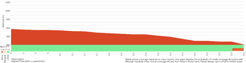
Analysis and summary of the altitude variation on the Queen Victoria Lookout
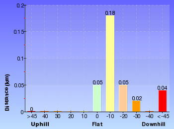
Overview of this walks grade – based on the AS 2156.1 – 2001
Under this standard, a walk is graded based on the most difficult section of the walk.
| Length | 696 m | ||
| Time | 30 mins | ||
| . | |||
| Grade 3/6 Moderate track |
AS 2156.1 | Gradient | Short steep hills (3/6) |
| Quality of track | Clear and well formed track or trail (2/6) | ||
| Signs | Clearly signposted (1/6) | ||
| Experience Required | No experience required (1/6) | ||
| Weather | Weather generally has little impact on safety (1/6) | ||
| Infrastructure | Limited facilities, not all cliffs are fenced (3/6) |
Some more details of this walks Grading
Here is a bit more details explaining grading looking at sections of the walk
Gradient
Around 270m of this walk has short steep hills, whilst the remaining 80m has gentle hills with occasional steps.
Quality of track
Around 290m of this walk follows a clear and well formed track or trail, whilst the remaining 55m follows a smooth and hardened path.
Signs
This whole walk, 350m is clearly signposted.
Experience Required
This whole walk, 350m requires no previous bushwalking experience.
weather
This whole walk, 350m is not usually affected by severe weather events (that would unexpectedly impact safety and navigation).
Infrastructure
Around 270m of this walk has limited facilities (such as not all cliffs fenced), whilst the remaining 80m is close to useful facilities (such as fenced cliffs and seats).
Similar walks
A list of walks that share part of the track with the Queen Victoria Lookout walk.
762 m Return
30 mins
Moderate track
950 m Circuit
30 mins
Moderate track
1.1 km One way
30 mins
Moderate track
1.1 km Return
1 Hr
Hard track
1.5 km Return
1 hr 30 mins
Hard track
1.9 km Circuit
1 Hr
Moderate track
3.1 km Circuit
2 hrs
Hard track
3.6 km One way
3 hrs
Hard track
3.8 km Return
4 hrs
Experienced only
4 km Circuit
2 hrs
Moderate track
4.6 km Circuit
3 hrs 30 mins
Hard track
4.8 km Circuit
4 hrs
Hard track
5 km Circuit
4 hrs
Hard track
5.1 km Circuit
4 hrs
Hard track
6.7 km Circuit
3 hrs
Hard track
8.6 km Circuit
5 hrs
Hard track
8.9 km Circuit
4 hrs 30 mins
Hard track
9.4 km Circuit
4 hrs
Moderate track
9.5 km Circuit
5 hrs 30 mins
Hard track
10.2 km Circuit
6 hrs
Hard track
Other Nearby walks
A list of walks that start near the Queen Victoria Lookout walk.
1.5 km Return
45 mins
Moderate track
1.4 km Circuit
45 mins
Moderate track
1.3 km Circuit
45 mins
Moderate track
926 m Return
45 mins
Hard track
746 m Return
45 mins
Moderate track
2.9 km Return
1 hr 30 mins
Moderate track
1.7 km Circuit
1 Hr
Hard track
2.2 km Circuit
1 hr 30 mins
Hard track
2 km Circuit
1 hr 30 mins
Moderate track
1.3 km Return
1 Hr
Moderate track
880 m Return
30 mins
Moderate track
1.6 km Return
1 Hr
Moderate track
Plan your trip to and from the walk here
The Queen Victoria Lookout walk starts and ends at the Conservation Hut (gps: -33.720216, 150.3629)
Your transport options to Conservation Hut are by;
![]() Bus. (get details)
Bus. (get details)
![]() Car. There is free parking available.
Car. There is free parking available.
(get details)
Short URL = http://wild.tl/qvl
Gallery images
There are other downloads I am still working on.
You will probably need to login to access these — still all free.
* KML (google earth file)
* GPX (GPS file)
Special Maps/ brochures
* A3 topo maps
* PDF with Lands Topo map base
* PDF with arial image (and map overlay)
I wanted to get the main site live first, this extra stuff will come in time.
Happy walking
Matt 🙂
Conservation Hut to Breakfast Point Lookout

1 Hr
1.9 km Circuit
156 m
Moderate track
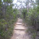
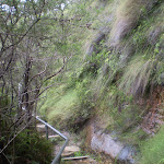


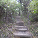
Conservation Hut
Conservation Hut is a small cafe perched above the Valley of the Waters, Blue Mountains National Park. The hut was opened in 1963 as a meeting place for the local conservation movement. Rebuilt, Conservation Hut opened as a cafe in 1993, serving breakfast, lunch and dinner, seven days a week. Around the Conservation Hut is a small parking area, public toilets, picnic shelters, town water and B&B’s. For further information or bookings call (02) 4757 3827. More info.
(0km) Conservation Hut → Int of Valley of the Waters Track and Shortcut Track
40 m
1 mins
0m
-6m
Easy track
From Conservation Hut, this walk follows the ‘Valley of the Waters’ sign down some timber and dirt steps passing a couple of picnic shelters. The track soon leads to the signposted intersection with the ‘Short Cut Track’ (still in view of the Conservation Hut).
(0.04km) Int of Valley of the Waters Track and Shortcut Track → Int of Shortcut and Breakfast Point Lookout Tracks
350 m
8 mins
13m
-18m
Moderate track
Turn left : From the intersection, the walk heads along the ‘Short Cut Track’ following the arrow to ‘Wentworth Falls picnic area’. The track gradually heads downhill with small log steps. After a short distance, the walk crosses a small creek using a bridge. The track then bends to the right and continues along till comes to a signposted intersection with another track (on the right).
Continue straight: From the intersection, the walk follows the sign to ‘Wentworth Falls picnic area’ that heads south-east along the flat bush track. Soon the walk comes to a 4-way intersection marked with signs pointing to Breakfast Pt Lookout, Murphy’s Lane and to the Falls Picnic Area.
Continue straight: From the intersection, the walk follows the sign to ‘Wentworth Falls picnic area’ that heads south-east along the flat bush track. Soon the walk comes to a 4-way intersection marked with signs pointing to Breakfast Pt Lookout, Murphy’s Lane and to the Falls Picnic Area.
(0.39km) Int of Shortcut and Breakfast Point Lookout Tracks → Breakfast Point Lookout
430 m
9 mins
1m
-53m
Moderate track
Turn right: From the intersection, this walk heads down the gentle hill, following the ‘Breakfast Pt. LO’ sign to the south. The track gradually heads downhill until it turns to the left, where the track becomes slightly steeper. After a short while, the walk turns back to the right and the track becomes rougher, continuing down the hill to Breakfast Point Lookout, and an intersection with the Overcliff Track.
Breakfast Point Lookout
Breakfast Point Lookout is on the Overcliff Walk, west of Den Fenella Creek. The lookout has a short stone wall and great views across the Jamison Valley. The center piece of the view is out to Mount Solitary and beyond, there are also good views to Kings Tableland (left). This is a good spot to stop and enjoy the sweeping views of the majestic valley.
(0.82km) Breakfast Point Lookout → Lyrebird Lookout
640 m
21 mins
75m
-78m
Moderate track
Turn right: From Breakfast Point Lookout, this walk follows the Overcliff Track west, keeping the valley views to the left. The track soon passes an informal track (on the left) before heading along the base of a large rock wall (on the right). The track then heads up the steps following the handrail – soon after the end of the handrail, the track passes another informal track (on the left). After passing an often muddy section of track, this walk turns left at the intersection, then heads a few meters to the fenced and signposted ‘Lyrebird Lookout’.
Lyrebird Lookout
Lyrebird Lookout is a fenced and signposted lookout on the Overcliff Walk, south of the Conservation Hut in the Blue Mountains National Park. The lookout hosts a great view of Sublime Point (right) and Mount Solitary (centre). A welcome gap in the trees reveals this great view.
(1.45km) Lyrebird Lookout → Int of Valley of the Waters and Overcliff Tracks
220 m
6 mins
34m
-1m
Moderate track
Continue straight: From Lyrebird Lookout, this walk keeps the green fence to the left and follows the track into the bush (with the valley behind and to the left). The walk crosses a section that is normally wet and muddy, and soon comes to a unsignposted ‘Y’ intersection with the Lyrebird Cliff Track on the left.
Continue straight: From the intersection, this walk takes the upper track and heads north-west. This goes up slightly before flattening out and continuing away from the cliffs, until coming to an intersection with a well-managed track, signposted as the Overcliff Track
Continue straight: From the intersection, this walk takes the upper track and heads north-west. This goes up slightly before flattening out and continuing away from the cliffs, until coming to an intersection with a well-managed track, signposted as the Overcliff Track
(1.67km) Int of Valley of the Waters and Overcliff Tracks → Conservation Hut
210 m
5 mins
33m
-2m
Moderate track
Turn right: From the intersection, this walk follows the ‘National Pass – Tea Rooms’ sign up the steps, with the handrail on the left. After a short time, the track passes a couple of faint tracks (on the right, leading to an old picnic area). Heading up the main steps, the walk passes another handrail (and signs) then an information sign, before coming to a three-way intersection with the ‘Shortcut Track’.
Continue straight: From the intersection, this walk heads up the steps towards the building. The walk passes a couple of picnic shelters (on the right) before coming to the road and the front of the ‘Conservation Hut’.
Continue straight: From the intersection, this walk heads up the steps towards the building. The walk passes a couple of picnic shelters (on the right) before coming to the road and the front of the ‘Conservation Hut’.
Maps for the Conservation Hut to Breakfast Point Lookout walk
You can download the PDF for this walk to print a map.
These maps below cover the walk and the wider area around the walk, they are worth carrying for safety reasons.
| Katoomba | 1:25 000 Map Series | 89301S KATOOMBA | NSW-89301S |
| Katoomba | 1:100 000 Map Series | 8930 KATOOMBA | 8930 |
Cross sectional view of the Conservation Hut to Breakfast Point Lookout bushwalking track
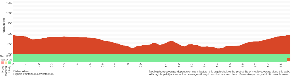
Analysis and summary of the altitude variation on the Conservation Hut to Breakfast Point Lookout
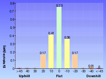
Overview of this walks grade – based on the AS 2156.1 – 2001
Under this standard, a walk is graded based on the most difficult section of the walk.
| Length | 1.9 km | ||
| Time | 1 Hr | ||
| . | |||
| Grade 3/6 Moderate track |
AS 2156.1 | Gradient | Short steep hills (3/6) |
| Quality of track | Formed track, with some branches and other obstacles (3/6) | ||
| Signs | Directional signs along the way (3/6) | ||
| Experience Required | Some bushwalking experience recommended (3/6) | ||
| Weather | Storms may impact on navigation and safety (3/6) | ||
| Infrastructure | Limited facilities, not all cliffs are fenced (3/6) |
Some more details of this walks Grading
Here is a bit more details explaining grading looking at sections of the walk
Gradient
1.4km of this walk has gentle hills with occasional steps and another 330m has short steep hills. The remaining (110m) is flat with no steps.
Quality of track
820m of this walk follows a clear and well formed track or trail and another 640m follows a formed track, with some branches and other obstacles. The remaining (430m) follows a smooth and hardened path.
Signs
Around 1.2km of this walk is clearly signposted, whilst the remaining 640m has directional signs at most intersection.
Experience Required
Around 1.2km of this walk requires no previous bushwalking experience, whilst the remaining 690m requires some bushwalking experience.
weather
Around 1.2km of this walk is not usually affected by severe weather events (that would unexpectedly impact safety and navigation), whilst the remaining 640m is affected by storms that may impact your navigation and safety.
Infrastructure
Around 1.6km of this walk has limited facilities (such as not all cliffs fenced), whilst the remaining 320m is close to useful facilities (such as fenced cliffs and seats).
Similar walks
A list of walks that share part of the track with the Conservation Hut to Breakfast Point Lookout walk.
696 m Return
30 mins
Moderate track
762 m Return
30 mins
Moderate track
950 m Circuit
30 mins
Moderate track
1.1 km One way
30 mins
Moderate track
1.1 km Return
1 Hr
Hard track
1.5 km Return
1 hr 30 mins
Hard track
3.1 km Circuit
2 hrs
Hard track
3.6 km One way
3 hrs
Hard track
3.8 km Return
4 hrs
Experienced only
4 km Circuit
2 hrs
Moderate track
4.6 km Circuit
3 hrs 30 mins
Hard track
4.8 km Circuit
4 hrs
Hard track
5 km Circuit
4 hrs
Hard track
5.1 km Circuit
4 hrs
Hard track
6.7 km Circuit
3 hrs
Hard track
8.6 km Circuit
5 hrs
Hard track
8.9 km Circuit
4 hrs 30 mins
Hard track
9.4 km Circuit
4 hrs
Moderate track
9.5 km Circuit
5 hrs 30 mins
Hard track
10.2 km Circuit
6 hrs
Hard track
Other Nearby walks
A list of walks that start near the Conservation Hut to Breakfast Point Lookout walk.
1.5 km Return
45 mins
Moderate track
1.4 km Circuit
45 mins
Moderate track
1.3 km Circuit
45 mins
Moderate track
926 m Return
45 mins
Hard track
746 m Return
45 mins
Moderate track
2.9 km Return
1 hr 30 mins
Moderate track
1.7 km Circuit
1 Hr
Hard track
2.2 km Circuit
1 hr 30 mins
Hard track
2 km Circuit
1 hr 30 mins
Moderate track
1.3 km Return
1 Hr
Moderate track
880 m Return
30 mins
Moderate track
1.6 km Return
1 Hr
Moderate track
Plan your trip to and from the walk here
The Conservation Hut to Breakfast Point Lookout walk starts and ends at the Conservation Hut (gps: -33.720216, 150.3629)
Your transport options to Conservation Hut are by;
![]() Bus. (get details)
Bus. (get details)
![]() Car. There is free parking available.
Car. There is free parking available.
(get details)
Short URL = http://wild.tl/chtbpl
Gallery images
There are other downloads I am still working on.
You will probably need to login to access these — still all free.
* KML (google earth file)
* GPX (GPS file)
Special Maps/ brochures
* A3 topo maps
* PDF with Lands Topo map base
* PDF with arial image (and map overlay)
I wanted to get the main site live first, this extra stuff will come in time.
Happy walking
Matt 🙂
The Princes Rock Track
And Walk
The Princes Rock Track
45 mins
746 m Return
61 m
Moderate track
From Wentworth Falls Picnic area, this walk explores some great lookouts and their vistas. The views of Jamison Valley, Mount Solitary and the Kings Tableland are simply spectacular. This walk goes down a moderate slope, along a well-managed track to Princes Rock Lookout. Take your time on the walk back up and consider a picnic lunch back at the picnic area

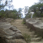
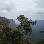
Jamison Lookout
The recently renovated Jamison Lookout is on Sir H Burrell Drive, in the Blue Mountains National Park. The lookout has a wonderful view to the south, down the Jamison Valley to Mount Solitary and beyond. This is a great wheelchair-accessible viewpoint with a large information sign and bench seats. The lookout is fenced, and is located just below the Wentworth Falls Picnic Area.
(0km) Jamison Lookout → Int of Princes Rock and Wentworth Falls Lookout Track
220 m
4 mins
5m
-13m
Easy track
From Jamison Lookout, this walk follows the footpath along Sir H. Burrell Drive, past the information sign, keeping the Jamison Valley to the right. Soon the footpath leads to an intersection at the top of some steps (signposted as the way to ‘Princes Rock Lookout’).
Turn right: From the top of the steps, this walk heads down the steps following the ‘Princes Rock Lookout’ sign. The track soon comes to a three-way intersection, with a ‘Car Park’ arrow pointing back up.
Turn right: From the top of the steps, this walk heads down the steps following the ‘Princes Rock Lookout’ sign. The track soon comes to a three-way intersection, with a ‘Car Park’ arrow pointing back up.
(0.22km) Int of Princes Rock and Wentworth Falls Lookout Track → Princes Rock
160 m
6 mins
1m
-42m
Moderate track
Continue straight: From the intersection, this walk follows the ‘Princes Rock Lookout’ arrow down the log steps. The walk passes an old water trough (not suitable for drinking) and continues down the hill, soon passing over a rock platform with steps carved in it. After a few more log steps, the walk comes to a signposted intersection with a track heading off to the ‘Undercliff track’.
Continue straight: From the intersection, this walk heads downhill following the ‘Princes Rock Lookout 200m’ sign along the wide track. Very soon, the walk comes to an intersection with another track (on the left – which was closed at time of writing).
Continue straight: From the intersection, the walk heads down the gentle hill towards the cliffs and the fenced (unsignposted) Princes Rock Lookout.
Princes Rock
Princes Rock is a great fenced lookout, to the west of Wentworth Falls. There are extensive views into the Jamison Valley below. The lookout has an excellent view of Wentworth Falls, cascading over the cliffs opposite.
Maps for the The Princes Rock Track walk
You can download the PDF for this walk to print a map.
These maps below cover the walk and the wider area around the walk, they are worth carrying for safety reasons.
| Katoomba | 1:25 000 Map Series | 89301S KATOOMBA | NSW-89301S |
| Katoomba | 1:100 000 Map Series | 8930 KATOOMBA | 8930 |
Cross sectional view of the The Princes Rock Track bushwalking track
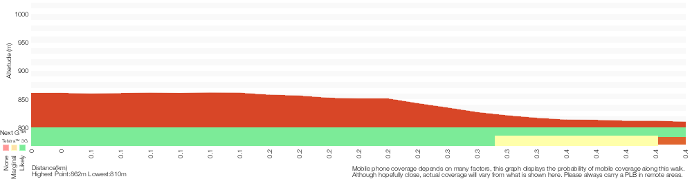
Analysis and summary of the altitude variation on the The Princes Rock Track
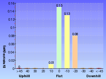
Overview of this walks grade – based on the AS 2156.1 – 2001
Under this standard, a walk is graded based on the most difficult section of the walk.
| Length | 746 m | ||
| Time | 45 mins | ||
| . | |||
| Grade 3/6 Moderate track |
AS 2156.1 | Gradient | Short steep hills (3/6) |
| Quality of track | Clear and well formed track or trail (2/6) | ||
| Signs | Clearly signposted (1/6) | ||
| Experience Required | No experience required (1/6) | ||
| Weather | Weather generally has little impact on safety (1/6) | ||
| Infrastructure | Generally useful facilities (such as fenced cliffs and seats) (1/6) |
Some more details of this walks Grading
Here is a bit more details explaining grading looking at sections of the walk
Gradient
150m of this walk is flat with no steps and another 140m has short steep hills. The remaining (85m) has gentle hills with occasional steps.
Quality of track
Around 230m of this walk follows a clear and well formed track or trail, whilst the remaining 140m follows a smooth and hardened path.
Signs
This whole walk, 370m is clearly signposted.
Experience Required
This whole walk, 370m requires no previous bushwalking experience.
weather
This whole walk, 370m is not usually affected by severe weather events (that would unexpectedly impact safety and navigation).
Infrastructure
This whole walk, 370m is close to useful facilities (such as fenced cliffs and seats).
Similar walks
A list of walks that share part of the track with the The Princes Rock Track walk.
1.3 km Circuit
45 mins
Moderate track
1.7 km Circuit
1 Hr
Hard track
2 km Circuit
1 hr 30 mins
Moderate track
2.2 km Circuit
1 hr 30 mins
Hard track
3.6 km One way
3 hrs
Hard track
4.6 km Circuit
3 hrs 30 mins
Hard track
5 km Circuit
4 hrs
Hard track
8.9 km Circuit
4 hrs 30 mins
Hard track
Other Nearby walks
A list of walks that start near the The Princes Rock Track walk.
926 m Return
45 mins
Hard track
1.5 km Return
45 mins
Moderate track
1.4 km Circuit
45 mins
Moderate track
1.3 km Return
1 Hr
Moderate track
3.1 km Circuit
2 hrs
Hard track
4.8 km Circuit
4 hrs
Hard track
1.9 km Circuit
1 Hr
Moderate track
1.1 km Return
1 Hr
Hard track
762 m Return
30 mins
Moderate track
950 m Circuit
30 mins
Moderate track
4 km Circuit
2 hrs
Moderate track
696 m Return
30 mins
Moderate track
Plan your trip to and from the walk here
The The Princes Rock Track walk starts and ends at the Jamison Lookout (gps: -33.725513, 150.36904)
Your main transport option to Jamison Lookout is by;
![]() Car. There is free parking available.
Car. There is free parking available.
(get details)
Short URL = http://wild.tl/tprt
Gallery images
There are other downloads I am still working on.
You will probably need to login to access these — still all free.
* KML (google earth file)
* GPX (GPS file)
Special Maps/ brochures
* A3 topo maps
* PDF with Lands Topo map base
* PDF with arial image (and map overlay)
I wanted to get the main site live first, this extra stuff will come in time.
Happy walking
Matt 🙂
Comments