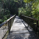
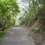
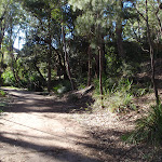
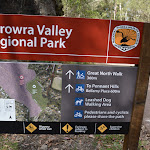
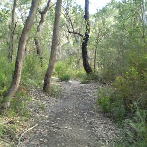
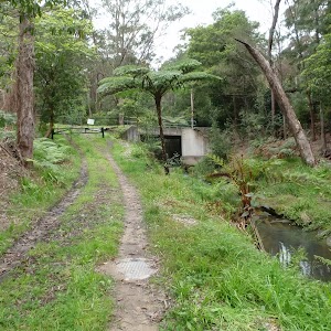
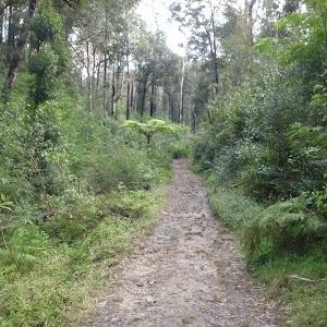
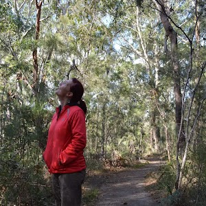
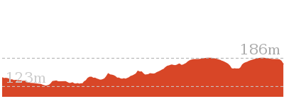
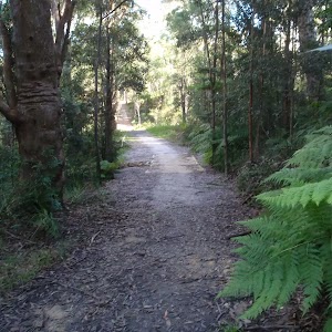
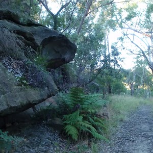
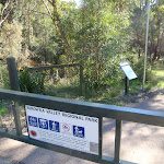
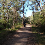
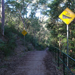
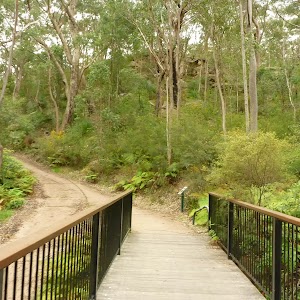
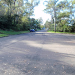
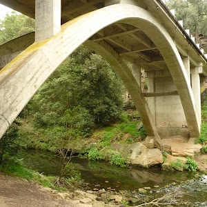
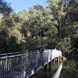
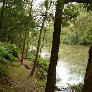
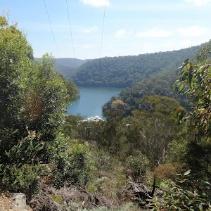
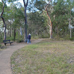
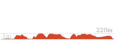
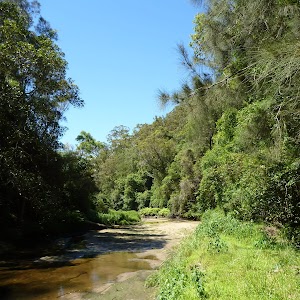
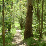
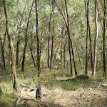
This walk follows a wide concrete trail through Berowra Valley Regional Park, through lovely bushland and the site of the historic Zig Zag railway. The railway is long gone, but the quarry site is interesting to explore and crossing Zig Zag Creek on the bridge gives a lovely view down on the fern trees. Stop and read the information signs along the way, bring your dog for a walk or use this trail for fitness training. The trail on the north side of Zig Zag Creek is very steep for about 50m, otherwise, this walk is easy to follow. To save the car shuttle you can just allow extra time and retrace your steps back to the start.
Bellamy fire trail
And Walk
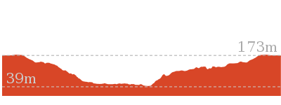
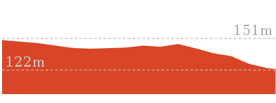
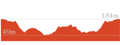
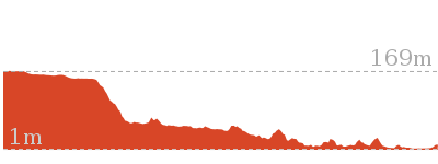
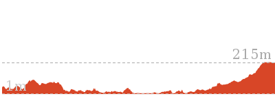
Bellamy fire trail


30 mins
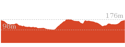
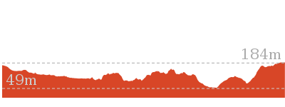
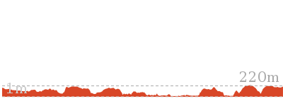
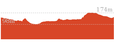
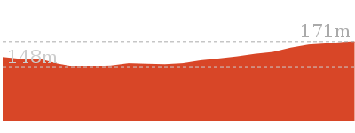
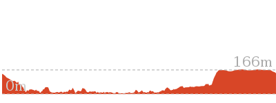
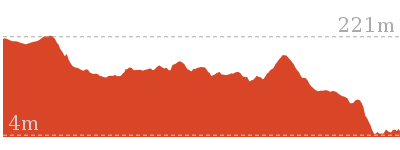
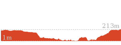
619 m One way

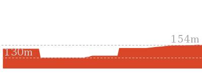
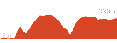
34 m
Moderate track


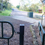
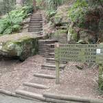
(0km) End of Bellamy St → Int of Bellamy trail and Morgan Rd tracks

90 m
2 mins
0m
-10m
Easy track
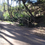
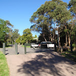
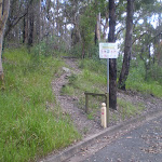
From the end of Bellamy St (Pennant Hills), the walk passes around the locked metal gate[1]

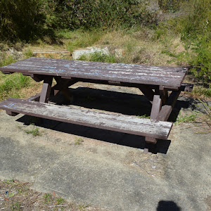
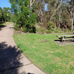
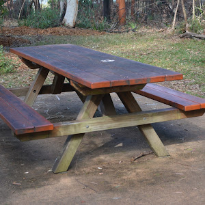
and follows the ‘To Westleigh’ arrow[2] downhill along the concrete management trail. After about 25m this walk leads past a picnic table

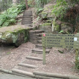
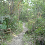
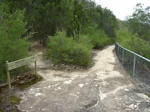
[3] (on the left) then over the next 50m this walk continues downhill past the ‘Halls Camp’ information sign[4], the ‘Natures Filter’[5] to come to an intersection with a dirt track (the Great North Walk) marked with an arrow pointing back up to ‘Bellamy Street’[6].
(0.09km) Int of Bellamy trail and Morgan Rd tracks → Zig Zag Creek Bridge int.
130 m
2 mins
0m
-6m
Easy track
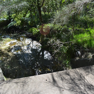
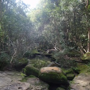
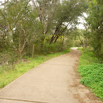
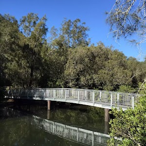
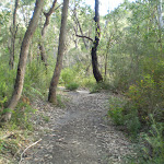
Continue straight: From the intersection, this walk follows the ‘The Jungo’ arrow[7] downhill along the wide concrete trail for 25m to cross over the culverted creek[8] (with a green rail[9] on one side)

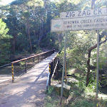
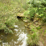
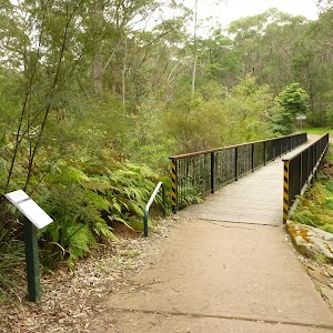
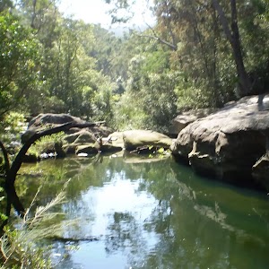
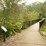
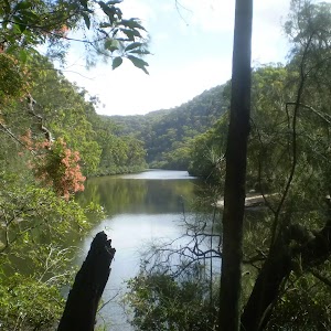
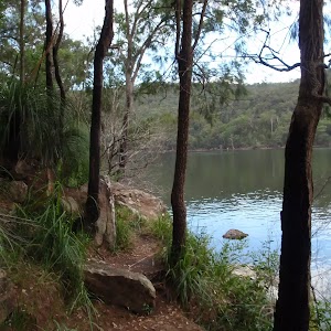
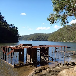
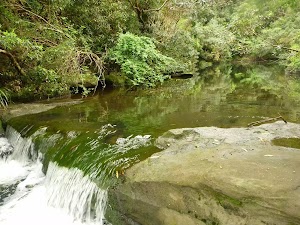
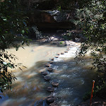
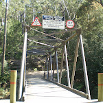
. The walk continues down into the valley[10] along the concrete trail for another 110m to come to a signposted intersection marked with a ‘Great North Walk’ sign[11][12] (on your left), just before ‘Zig Zag Creek’[13] and the long bridge[14].
Thornleigh zigzag railway
The Thornleigh zigzag railway originally ran from the main rail line near Thornleigh to a historic quarry, near present day De Saxe Cl, Thornleigh. There are only minor fragments still visible today. The ‘Heritage Trail’ in Thornleigh has interpretive signs for the railway and the old Thornleigh Quarry. A book is available with some detail on railway and associated quarry: ‘Sydney’s Forgotten Quarry Railways’ by John Oakes, ISBN 0 9757870 3 9
(0.22km) Zig Zag Creek Bridge int → Thornleigh Quarry
160 m
4 mins
15m
-8m
Moderate track
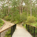
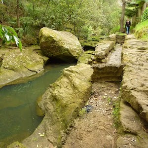
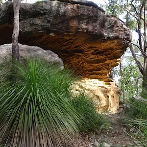
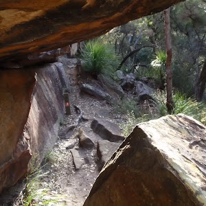
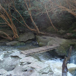
Continue straight: From the intersection, the walk heads gently downhill to then cross ‘Zig Zag Creek’[15] on the 40m long bridge[16] (with handrails) to find the ‘Zig Zag Siding’ information sign[17][18] on the far side. The bridge path now merges back to the main wide trail[19] and heads steeply uphill[20] for about 50m

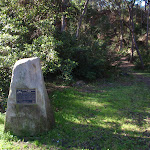
(with a handrail on the left side[21]). The trail then mostly flattens out for about 50m and leads gently up to the front of the old ‘Thornleigh Quarry’[22], marked with a plaque on a large stone[23][24][25]

.
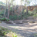
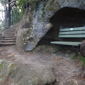
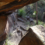
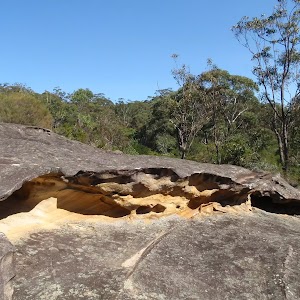
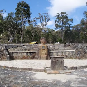
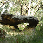
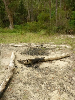
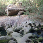
Old Thornleigh Quarry
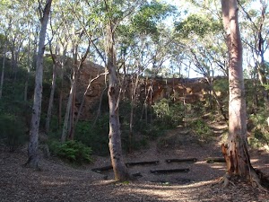
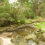
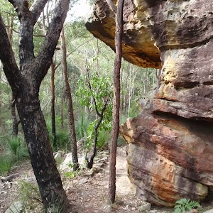
The old Thornleigh Quarry[26] is located beside the Heritage Trail in Thornleigh, within Berowra Valley Regional Park. The quarry dates back to 1883 and was initially a source of ‘ballast’ for portions of the Sydney (Homebush) to Newcastle (Waratah) rail link. There is a firm, flat dirt track[27] that leads about 40m from the concrete trail to the centre of the old quarry[28]. You will find a series of log seats in this amphitheatre
making this a pleasant spot to sit and enjoy the intriguing mix of nature and history. A book is available with some detail on this quarry and the associated zigzag railway: ‘Sydney’s Forgotten Quarry Railways’ by John Oakes, ISBN 0 9757870 3 9
(0.37km) Thornleigh Quarry → Int of Heritage Trail and De Saxe Cl trail
110 m
3 mins
11m
0m
Very easy
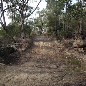
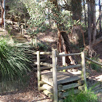
Continue straight: From the front of the old Thornleigh Quarry[29][30], this walk follows the wide concrete trail gently uphill, initially keeping the quarry to the right, passing ‘The Quarry’ information sign[31]. The trail meanders through the bush for about 100m to come to an intersection at the base of a set of timber stairs[32] (on the right).
(0.48km) Int of Heritage Trail and De Saxe Cl trail → End of Timbarra Rd
140 m
3 mins
8m
-3m
Easy track
Continue straight: From the intersection, this walk follows the concrete management trail gently uphill keeping the valley to the left. After about 40m the trail leads along the side of a small rock wall[33] to pass a ‘Berowra Valley Regional Park’ map sign[34] then about 25m later the trail leads past the old girl guide hall[35]. The walk continues along the concrete trail for another 50m to pass a ‘Heritage Trail’[36] sign then head around the gate[37]

Maps for the Bellamy fire trail walk
You can download the PDF for this walk to print a map.
These maps below cover the walk and the wider area around the walk, they are worth carrying for safety reasons.
| Hornsby | 1:25 000 Map Series | 91304S HORNSBY | NSW-91304S |
| Sydney | 1:100 000 Map Series | 9130 SYDNEY | 9130 |
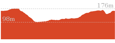
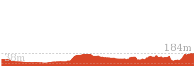
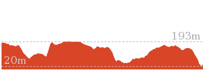
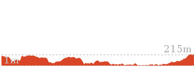
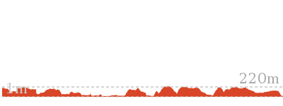
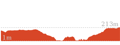
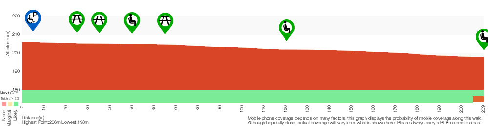
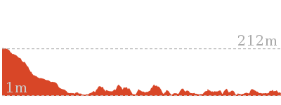
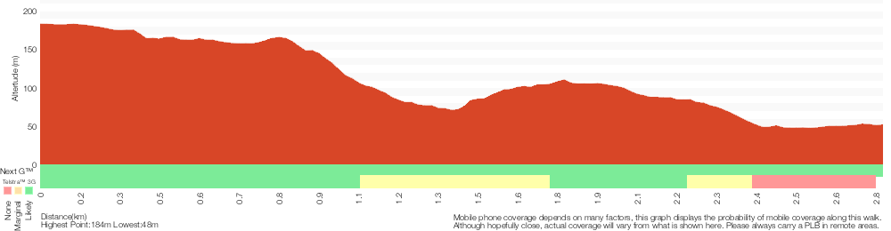
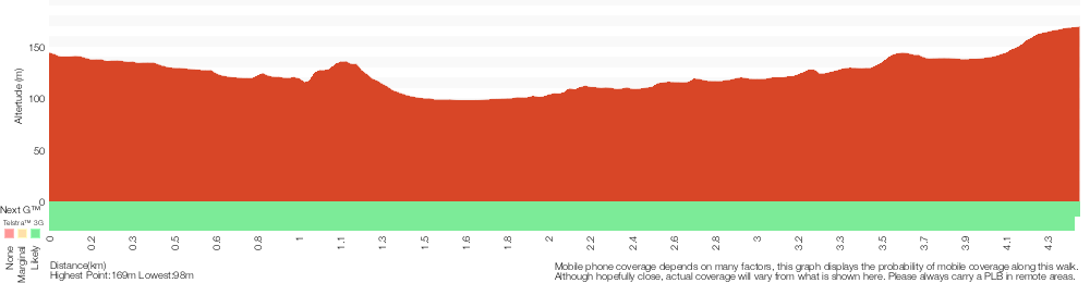
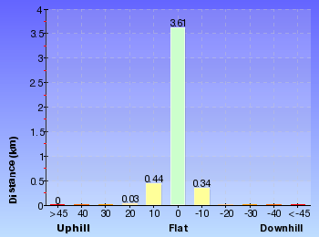
Cross sectional view of the Bellamy fire trail bushwalking track
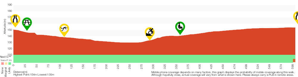
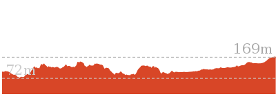
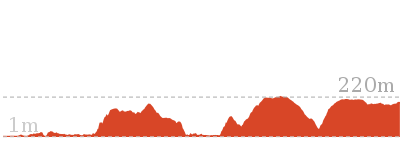
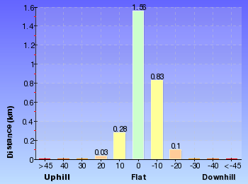
Analysis and summary of the altitude variation on the Bellamy fire trail
Accessibility summary information for the Bellamy fire trail
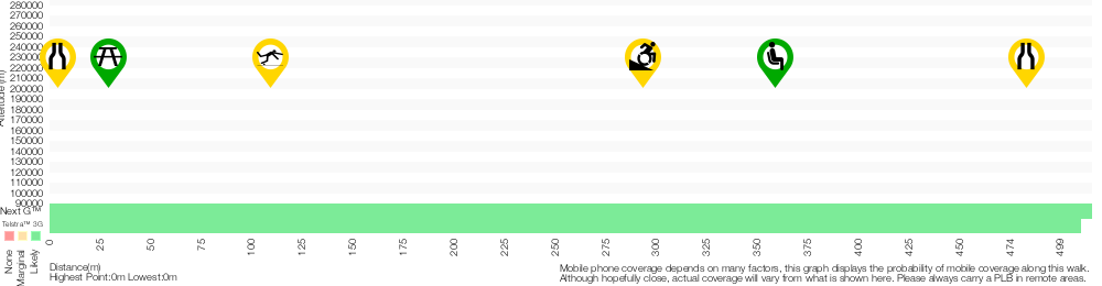
Parking: There are 0 designated accessible parking areas on this walk.
Toilets: There are 0 designated accessible toilets on this walk.
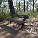
Seats: There are 2 places to sit on this walk.
They are 350m apart.
Hazards: There are 2 specific noteable accessability related hazards on this walk.
Trip Hazard Unfenced and unmarked edge with potential 80cm or higher fall into the creek. Keep clear of the culverts edge when crossing. Found about 110m into the walk.
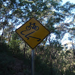
Wheelchair Steep A 45m long section of concrete trail (3.3m wide) that is very steep. There is a metal handrail on one side for most of the steep section. If using a wheelchair assistance is very likely required. Found about 300m into the walk.
Accessibility Details

Found 0m into this walk
Found 30m into this walk

Found 300m into this walk


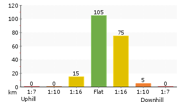
Overview of this walks grade – based on the AS 2156.1 – 2001
Under this standard, a walk is graded based on the most difficult section of the walk.
| Length | 619 m | ||
| Time | 30 mins | ||
| . | |||
| Grade 3/6 Moderate track |
AS 2156.1 | Gradient | Short steep hills (3/6) |
| Quality of track | Clear and well formed track or trail (2/6) | ||
| Signs | Clearly signposted (1/6) | ||
| Experience Required | No experience required (1/6) | ||
| Weather | Weather generally has little impact on safety (1/6) | ||
| Infrastructure | Generally useful facilities (such as fenced cliffs and seats) (1/6) |
Some more details of this walks Grading
Here is a bit more details explaining grading looking at sections of the walk
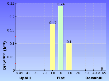
Gradient
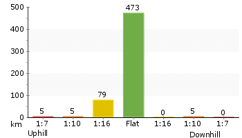
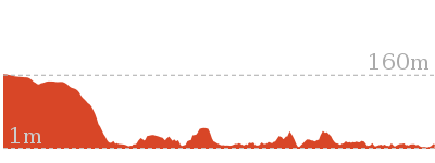
250m of this walk is flat with no steps and another 220m has gentle hills with occasional steps. The remaining (160m) has short steep hills.
Quality of track
Around 480m of this walk follows a smooth and hardened path, whilst the remaining 140m follows a clear and well formed track or trail.
Signs
This whole walk, 620m is clearly signposted.
Experience Required
This whole walk, 620m requires no previous bushwalking experience.
weather
This whole walk, 620m is not usually affected by severe weather events (that would unexpectedly impact safety and navigation).
Infrastructure
This whole walk, 620m is close to useful facilities (such as fenced cliffs and seats).
Similar walks
A list of walks that share part of the track with the Bellamy fire trail walk.
529 m One way
15 mins
Moderate track

4.2 km Circuit
1 hr 45 mins
Hard track

4.4 km One way
1 hr 45 mins
Moderate track
6.6 km Circuit
2 hrs 30 mins
Hard track
8.6 km One way
3 hrs 45 mins
Hard track
10.2 km One way
4 hrs
Hard track
15.5 km One way
6 hrs
Hard track
17.5 km One way
6 hrs 45 mins
Hard track

20.6 km One way
8 hrs
Hard track

25.8 km One way
2 Days
Hard track

28.1 km One way
2 Days
Hard track

35.9 km One way
2 Days
Hard track

44.4 km One way
3 Days
Hard track

Other Nearby walks
A list of walks that start near the Bellamy fire trail walk.
6.1 km One way
2 hrs 30 mins
Hard track
8.2 km Circuit
3 hrs
Hard track
2.5 km Return
1 hr 30 mins
Hard track
828 m Return
30 mins
Moderate track
717 m Circuit
20 mins
Very easy


5.1 km Circuit
2 hrs
Hard track
9 km One way
3 hrs 45 mins
Hard track
4.1 km One way
1 hr 45 mins
Moderate track

439 m Circuit
15 mins
Moderate track
2.2 km One way
1 Hr
Moderate track
515 m One way
15 mins
Moderate track
Plan your trip to and from the walk here
The Bellamy fire trail walk starts at the End of Bellamy St (gps: -33.728765, 151.06981)
Your main transport option to End of Bellamy St is by;
![]() Car. There is free parking available.
Car. There is free parking available.
(get details)
The Bellamy fire trail ends at the End of Timbarra Rd (gps: -33.724319, 151.07005)
Your main transport option to End of Timbarra Rd is by;
![]() Car. There is free parking available.
Car. There is free parking available.
(get details)


Short URL = http://wild.tl/bft
Gallery images
There are other downloads I am still working on.
You will probably need to login to access these — still all free.
* KML (google earth file)
* GPX (GPS file)
Special Maps/ brochures
* A3 topo maps
* PDF with Lands Topo map base
* PDF with arial image (and map overlay)
I wanted to get the main site live first, this extra stuff will come in time.
Happy walking
Matt 🙂
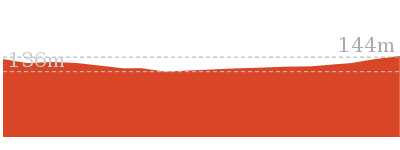
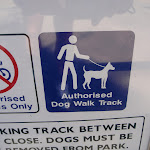
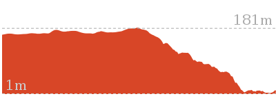
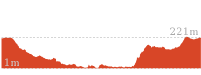
Bellamy St to De Saxe Cl dog walking trail

15 mins
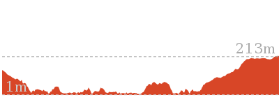
529 m One way
36 m
Moderate track
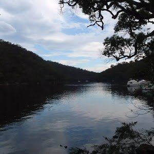
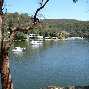
This short walk follows a concrete management trail between Bellamy St and De Saxe Close. This is one of a few dog friendly bushwalks in the Berowra Valley Regional Park. You walk through some beautiful bush with a good array of grass and eucalyptus trees. At the bottom of the valley a bridge spans ZigZag Creek allowing you to keep you feet dry. There are also some good information signs explaining the rich history of the railway line and quarry that once passed through here. The authorised dog walk exits up the steps to the base of De Saxe Cl. We have also include an alternate exit, staying on the main trail to then end of Timbarra Rd for those walking without dogs.


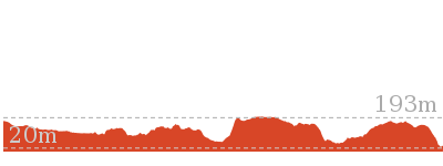
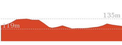
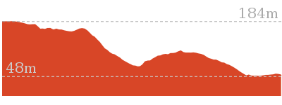
(0km) End of Bellamy St → Zig Zag Creek Bridge int.
220 m
4 mins
0m
-16m
Easy track
From the end of Bellamy St (Pennant Hills), the walk passes around the locked metal gate[1]
and follows the ‘To Westleigh’ arrow[2] downhill along the concrete management trail. After about 25m this walk leads past a picnic table
[3] (on the left) then over the next 50m this walk continues downhill past the ‘Halls Camp’ information sign[4], the ‘Natures Filter’[5] to come to an intersection with a dirt track (the Great North Walk) marked with an arrow pointing back up to ‘Bellamy Street’[6].
Continue straight: From the intersection, this walk follows the ‘The Jungo’ arrow[7] downhill along the wide concrete trail for 25m to cross over the culverted creek[8] (with a green rail[9] on one side)
. The walk continues down into the valley[10] along the concrete trail for another 110m to come to a signposted intersection marked with a ‘Great North Walk’ sign[11][12] (on your left), just before ‘Zig Zag Creek’[13] and the long bridge[14].
(0.22km) Zig Zag Creek Bridge int → Thornleigh Quarry
160 m
4 mins
15m
-8m
Moderate track
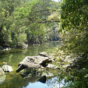
Continue straight: From the intersection, the walk heads gently downhill to then cross ‘Zig Zag Creek’[15] on the 40m long bridge[16] (with handrails) to find the ‘Zig Zag Siding’ information sign[17][18] on the far side. The bridge path now merges back to the main wide trail[19] and heads steeply uphill[20] for about 50m
(with a handrail on the left side[21]). The trail then mostly flattens out for about 50m and leads gently up to the front of the old ‘Thornleigh Quarry’[22], marked with a plaque on a large stone[23][24][25]
.
Old Thornleigh Quarry
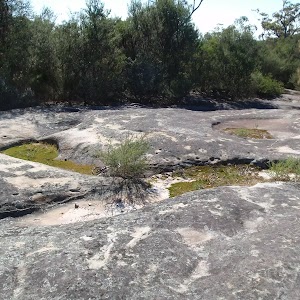
The old Thornleigh Quarry[26] is located beside the Heritage Trail in Thornleigh, within Berowra Valley Regional Park. The quarry dates back to 1883 and was initially a source of ‘ballast’ for portions of the Sydney (Homebush) to Newcastle (Waratah) rail link. There is a firm, flat dirt track[27] that leads about 40m from the concrete trail to the centre of the old quarry[28]. You will find a series of log seats in this amphitheatre
making this a pleasant spot to sit and enjoy the intriguing mix of nature and history. A book is available with some detail on this quarry and the associated zigzag railway: ‘Sydney’s Forgotten Quarry Railways’ by John Oakes, ISBN 0 9757870 3 9
(0.37km) Thornleigh Quarry → Int of Heritage Trail and De Saxe Cl trail
110 m
3 mins
11m
0m
Very easy
Continue straight: From the front of the old Thornleigh Quarry[29][30], this walk follows the wide concrete trail gently uphill, initially keeping the quarry to the right, passing ‘The Quarry’ information sign[31]. The trail meanders through the bush for about 100m to come to an intersection at the base of a set of timber stairs[32] (on the right).
(0.48km) Int of Heritage Trail and De Saxe Cl trail → End of Timbarra Rd
140 m
3 mins
8m
-3m
Easy track
Continue straight: From the intersection, this walk follows the concrete management trail gently uphill keeping the valley to the left. After about 40m the trail leads along the side of a small rock wall[33] to pass a ‘Berowra Valley Regional Park’ map sign[34] then about 25m later the trail leads past the old girl guide hall[35]. The walk continues along the concrete trail for another 50m to pass a ‘Heritage Trail’[36] sign then head around the gate[37]
(0.48km) Int of Heritage Trail and De Saxe Cl trail → End of De Saxe Close
50 m
2 mins
10m
0m
Moderate track
Turn right: From the intersection, the walk goes up the wooden steps and soon arrives at the end of De Saxe Cl.
Maps for the Bellamy St to De Saxe Cl dog walking trail walk
You can download the PDF for this walk to print a map.
These maps below cover the walk and the wider area around the walk, they are worth carrying for safety reasons.
| Hornsby | 1:25 000 Map Series | 91304S HORNSBY | NSW-91304S |
| Sydney | 1:100 000 Map Series | 9130 SYDNEY | 9130 |
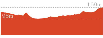
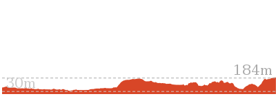
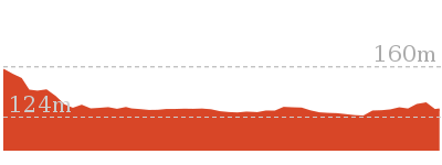
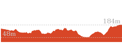
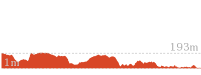
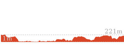
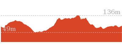
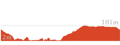
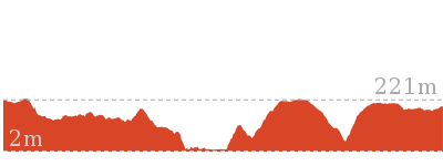
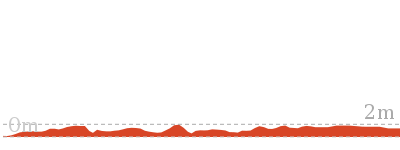
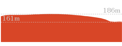
Cross sectional view of the Bellamy St to De Saxe Cl dog walking trail bushwalking track
Analysis and summary of the altitude variation on the Bellamy St to De Saxe Cl dog walking trail
Overview of this walks grade – based on the AS 2156.1 – 2001
Under this standard, a walk is graded based on the most difficult section of the walk.
| Length | 529 m | ||
| Time | 15 mins | ||
| . | |||
| Grade 3/6 Moderate track |
AS 2156.1 | Gradient | Short steep hills (3/6) |
| Quality of track | Clear and well formed track or trail (2/6) | ||
| Signs | Directional signs along the way (3/6) | ||
| Experience Required | No experience required (1/6) | ||
| Weather | Weather generally has little impact on safety (1/6) | ||
| Infrastructure | Generally useful facilities (such as fenced cliffs and seats) (1/6) |
Some more details of this walks Grading
Here is a bit more details explaining grading looking at sections of the walk
Gradient
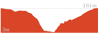
220m of this walk has gentle hills with occasional steps and another 210m has short steep hills. The remaining (110m) is flat with no steps.
Quality of track
Around 480m of this walk follows a smooth and hardened path, whilst the remaining 50m follows a clear and well formed track or trail.
Signs
Around 480m of this walk is clearly signposted, whilst the remaining 50m has directional signs at most intersection.
Experience Required
This whole walk, 530m requires no previous bushwalking experience.
weather
This whole walk, 530m is not usually affected by severe weather events (that would unexpectedly impact safety and navigation).
Infrastructure
This whole walk, 530m is close to useful facilities (such as fenced cliffs and seats).
Similar walks
A list of walks that share part of the track with the Bellamy St to De Saxe Cl dog walking trail walk.
619 m One way
30 mins
Moderate track
4.2 km Circuit
1 hr 45 mins
Hard track
4.4 km One way
1 hr 45 mins
Moderate track
6.6 km Circuit
2 hrs 30 mins
Hard track
8.6 km One way
3 hrs 45 mins
Hard track
10.2 km One way
4 hrs
Hard track
15.5 km One way
6 hrs
Hard track
17.5 km One way
6 hrs 45 mins
Hard track
20.6 km One way
8 hrs
Hard track
25.8 km One way
2 Days
Hard track
28.1 km One way
2 Days
Hard track
35.9 km One way
2 Days
Hard track
44.4 km One way
3 Days
Hard track
Other Nearby walks
A list of walks that start near the Bellamy St to De Saxe Cl dog walking trail walk.
6.1 km One way
2 hrs 30 mins
Hard track
8.2 km Circuit
3 hrs
Hard track
2.5 km Return
1 hr 30 mins
Hard track
828 m Return
30 mins
Moderate track
717 m Circuit
20 mins
Very easy
5.1 km Circuit
2 hrs
Hard track
9 km One way
3 hrs 45 mins
Hard track
4.1 km One way
1 hr 45 mins
Moderate track
439 m Circuit
15 mins
Moderate track
2.2 km One way
1 Hr
Moderate track
515 m One way
15 mins
Moderate track
Plan your trip to and from the walk here
The Bellamy St to De Saxe Cl dog walking trail walk starts at the End of Bellamy St (gps: -33.728765, 151.06981)
Your transport options to End of Bellamy St are by;
![]() Bus. (get details)
Bus. (get details)
![]() Car. There is free parking available.
Car. There is free parking available.
(get details)
The Bellamy St to De Saxe Cl dog walking trail ends at the End of De Saxe Close (gps: -33.72549, 151.06947)
Your transport options to End of De Saxe Close are by;
![]() Bus. (get details)
Bus. (get details)
![]() Car. There is free parking available.
Car. There is free parking available.
(get details)
Short URL = http://wild.tl/bstdscdwt
Gallery images
There are other downloads I am still working on.
You will probably need to login to access these — still all free.
* KML (google earth file)
* GPX (GPS file)
Special Maps/ brochures
* A3 topo maps
* PDF with Lands Topo map base
* PDF with arial image (and map overlay)
I wanted to get the main site live first, this extra stuff will come in time.
Happy walking
Matt 🙂
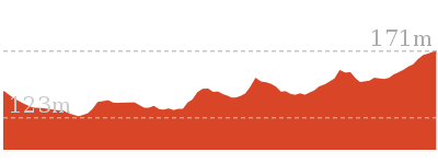
Clarinda St dog walking trail
And Walk
Clarinda St dog walking trail

15 mins
499 m One way
22 m
Easy track
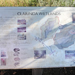
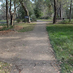
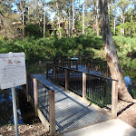
This short walk links Clarinda St and Simon Pl in Hornsby Heights. The walk follows a management trail and is one of three dog friendly walks in Berowra Valley Regional Park. Starting at the wetlands at the end of Clarinda St you follow the Great North Walk alternate route until the turn off to the Simon Place. Dogs on leash are most welcome on this section of the trail.


(0km) End of Clarinda St → Int of Clarinda St and Simon Pl trails
440 m
9 mins
10m
-35m
Easy track
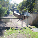
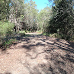
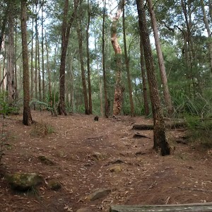
From the end of Clarinda St Hornsby, this walk heads around the green gate with the ‘Berowra Valley Regional Park’ sign on it, keeping the ‘Clarinda wetlands’ to the left. The walk follows the management trail, which soon bends left and gently winds through the bushland. There are some interesting rock formations on the right and the occasional valley view on the left. The track is fairly flat most of the way, until a left-hand bend that leads down to cross a small creek, and then up the other side of the valley. Once the track flattens out again, it comes to an intersection with the Simon Pl management trail on the right, at a fairly large clearing.
(0.44km) Int of Clarinda St and Simon Pl trails → End of Simon Place
60 m
2 mins
12m
-1m
Easy track
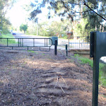
Turn right: From the intersection, this walk heads up the hill towards the gate. The management trail soon comes to the end of Simon Place, Hornsby Heights.
Maps for the Clarinda St dog walking trail walk
You can download the PDF for this walk to print a map.
These maps below cover the walk and the wider area around the walk, they are worth carrying for safety reasons.
| Hornsby | 1:25 000 Map Series | 91304S HORNSBY | NSW-91304S |
| Sydney | 1:100 000 Map Series | 9130 SYDNEY | 9130 |
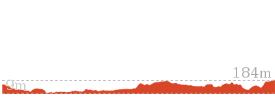
Cross sectional view of the Clarinda St dog walking trail bushwalking track
Analysis and summary of the altitude variation on the Clarinda St dog walking trail
Overview of this walks grade – based on the AS 2156.1 – 2001
Under this standard, a walk is graded based on the most difficult section of the walk.
| Length | 499 m | ||
| Time | 15 mins | ||
| . | |||
| Grade 2/6 Easy track |
AS 2156.1 | Gradient | Gentle hills with occasional steps (2/6) |
| Quality of track | Clear and well formed track or trail (2/6) | ||
| Signs | Clearly signposted (1/6) | ||
| Experience Required | No experience required (1/6) | ||
| Weather | Weather generally has little impact on safety (1/6) | ||
| Infrastructure | Generally useful facilities (such as fenced cliffs and seats) (1/6) |
Some more details of this walks Grading
Here is a bit more details explaining grading looking at sections of the walk
Gradient
Around 440m of this walk has gentle hills with occasional steps, whilst the remaining 60m is flat with no steps.
Quality of track
This whole walk, 500m follows a clear and well formed track or trail.
Signs
This whole walk, 500m is clearly signposted.
Experience Required
This whole walk, 500m requires no previous bushwalking experience.
weather
This whole walk, 500m is not usually affected by severe weather events (that would unexpectedly impact safety and navigation).
Infrastructure
This whole walk, 500m is close to useful facilities (such as fenced cliffs and seats).
Similar walks
A list of walks that share part of the track with the Clarinda St dog walking trail walk.
9.7 km One way
4 hrs
Hard track
15.5 km One way
6 hrs
Hard track
16.1 km One way
6 hrs 45 mins
Hard track
22.3 km One way
9 hrs
Hard track
22.6 km One way
9 hrs 18 mins
Hard track
28.1 km One way
2 Days
Hard track
35.9 km One way
2 Days
Hard track
43.1 km One way
3 Days
Hard track
Other Nearby walks
A list of walks that start near the Clarinda St dog walking trail walk.
4.2 km Circuit
2 hrs
Hard track

6.7 km Circuit
3 hrs
Hard track
5.6 km Return
2 hrs 30 mins
Hard track
6.5 km One way
2 hrs 30 mins
Hard track
8.6 km One way
3 hrs 45 mins
Hard track
12.9 km One way
5 hrs 30 mins
Hard track
12.6 km One way
5 hrs 30 mins
Hard track
5 km One way
1 hr 45 mins
Moderate track
11 km One way
4 hrs 30 mins
Hard track
9.6 km Circuit
4 hrs
Moderate track
12.9 km Circuit
5 hrs
Hard track
10.7 km One way
4 hrs 45 mins
Hard track
Plan your trip to and from the walk here
The Clarinda St dog walking trail walk starts at the End of Clarinda St (gps: -33.68809, 151.09174)
Your transport options to End of Clarinda St are by;
![]() Bus. (get details)
Bus. (get details)
![]() Car. There is free parking available.
Car. There is free parking available.
(get details)
The Clarinda St dog walking trail ends at the End of Simon Place (gps: -33.684643, 151.09121)
Your transport options to End of Simon Place are by;
![]() Bus. (get details)
Bus. (get details)
![]() Car. There is free parking available.
Car. There is free parking available.
(get details)
Short URL = http://wild.tl/csdwt
Gallery images
There are other downloads I am still working on.
You will probably need to login to access these — still all free.
* KML (google earth file)
* GPX (GPS file)
Special Maps/ brochures
* A3 topo maps
* PDF with Lands Topo map base
* PDF with arial image (and map overlay)
I wanted to get the main site live first, this extra stuff will come in time.
Happy walking
Matt 🙂
Barnetts Lookout
And Walk
Barnetts Lookout

15 mins
420 m Return
14 m
Very easy
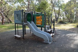
A very pleasant and easy stroll along a path to a stunning view. Starting from Barnetts Road car park you follow the footpath through the picnic area, past the playground then meander gently downhill through the open forest among the scribbly gum trees. You soon discover a fenced lookout platform with amazing views up and down the Berowra Valley. The views of trees go on forever, on a clear day you can even see the Blue Mountains.


(0km) Barnetts Road → Barnetts Picnic area
50 m
1 mins
0m
-2m
Very easy
From the ‘Barnetts Road Reserve’[1] car park[2][3]

(at the junction of Barnetts Rd and Wyanna St, Berowra), this walk follows the concrete footpath between the timber bollards[4] (1.3m gap[5]) away from the road. After 25m this walk passes a short path to a picnic table[6] (on the left), about 20m later this walk comes to another path and picnic table[7]

(on the right). Here the walk also comes to a drinking fountain[8] in the middle of the picnic area, beside a playground[9] and near some extra seats

.


(0.05km) Barnetts Picnic area → Barnetts Lookout
160 m
3 mins
0m
-12m
Very easy
Continue straight: From the picnic area, this walk follows the footpath away from the road and after about 25m the walk passes another picnic table[12]
(on the left). Here the walk continues on the main path, gently downhill through the open forest[13] for about 60m to a seat

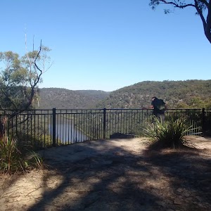
(beside the path, on the right). From the seat this walk continues winding gently downhill towards the views for another 70m to a intersection with a faint track[14] beside the plaque[15] commemorating the establishment of Berowra Valley NP. (The faint, less formal track, leads downhill for 60m to a fenced lookout[16]). From the plaque this walk continues a few more meters along the concrete path, around the bend to the left[17] to find the fenced[18] ‘Barrnetts Lookout’[19][20][21].
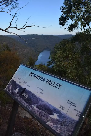
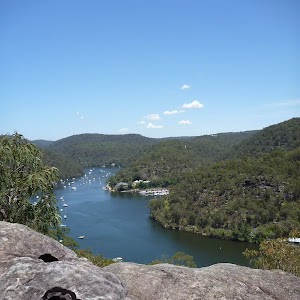
Barnetts Lookout
Barnetts Lookout provides stunning views over Berowra Creek and the surprisingly wild Berowra Valley NP. There are two stone seats

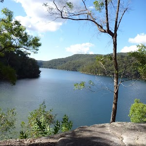
, a concrete base[22] (4.6x4m) and a 1.3m high[23] metal fence (filtered views when seated in a wheelchair[24]). To the left there are views upstream along Berowra Creek past Calna Creek[25], on a clear day you can just make out the Blue Mountains straight ahead and Berowra Waters[26] to the right[27].
Maps for the Barnetts Lookout walk
You can download the PDF for this walk to print a map.
These maps below cover the walk and the wider area around the walk, they are worth carrying for safety reasons.
| Cowan | 1:25 000 Map Series | 91304N COWAN | NSW-91304N |
| Ku-ring-gai Chase National Park Tourist Map | 1:40 000 Map Series | CMA Ku-ring-gai Chase National Park Tourist Map | CMA Ku-ring-gai Chase National Park Tourist Map |
| Sydney | 1:100 000 Map Series | 9130 SYDNEY | 9130 |
Cross sectional view of the Barnetts Lookout bushwalking track
Analysis and summary of the altitude variation on the Barnetts Lookout
Accessibility summary information for the Barnetts Lookout
Parking: There are 1 designated accessible parking areas on this walk.
Toilets: There are 0 designated accessible toilets on this walk.
Seats: There are 6 places to sit on this walk.
They are on average 40m apart, with a maximum gap of 90m.
Hazards: There are 0 specific noteable accessability related hazards on this walk.
Accessibility Details

Found 10m into this walk

Found 40m into this walk

Found 50m into this walk


Found 210m into this walk
Overview of this walks grade – based on the AS 2156.1 – 2001
Under this standard, a walk is graded based on the most difficult section of the walk.
| Length | 420 m | ||
| Time | 15 mins | ||
| . | |||
| Grade 1/6 Very easy |
AS 2156.1 | Gradient | Flat, no steps (1/6) |
| Quality of track | Smooth and hardened path (1/6) | ||
| Signs | Clearly signposted (1/6) | ||
| Experience Required | No experience required (1/6) | ||
| Weather | Weather generally has little impact on safety (1/6) | ||
| Infrastructure | Generally useful facilities (such as fenced cliffs and seats) (1/6) |
Some more details of this walks Grading
Here is a bit more details explaining grading looking at sections of the walk
Gradient
This whole walk, 210m is flat with no steps.
Quality of track
This whole walk, 210m follows a smooth and hardened path.
Signs
This whole walk, 210m is clearly signposted.
Experience Required
This whole walk, 210m requires no previous bushwalking experience.
weather
This whole walk, 210m is not usually affected by severe weather events (that would unexpectedly impact safety and navigation).
Infrastructure
This whole walk, 210m is close to useful facilities (such as fenced cliffs and seats).
Similar walks
A list of walks that share part of the track with the Barnetts Lookout walk.
Other Nearby walks
A list of walks that start near the Barnetts Lookout walk.
9.4 km One way
4 hrs 30 mins
Hard track

8.7 km One way
4 hrs
Hard track
5.7 km One way
2 hrs 45 mins
Hard track
12.9 km One way
6 hrs
Hard track
22.6 km One way
9 hrs 18 mins
Hard track
7.2 km One way
3 hrs 30 mins
Hard track
980 m Return
30 mins
Very easy

13.7 km Return
6 hrs
Hard track

14 km One way
7 hrs 30 mins
Hard track
8.2 km Return
3 hrs 30 mins
Hard track
27.4 km One way
2 Days
Hard track
9.7 km One way
4 hrs 15 mins
Hard track
Plan your trip to and from the walk here
The Barnetts Lookout walk starts and ends at the Barnetts Road (gps: -33.616836, 151.12988)
Your transport options to Barnetts Road are by;
![]() Bus. (get details)
Bus. (get details)
![]() Car. There is free parking available.
Car. There is free parking available.
(get details)
Short URL = http://wild.tl/9k
Gallery images
There are other downloads I am still working on.
You will probably need to login to access these — still all free.
* KML (google earth file)
* GPX (GPS file)
Special Maps/ brochures
* A3 topo maps
* PDF with Lands Topo map base
* PDF with arial image (and map overlay)
I wanted to get the main site live first, this extra stuff will come in time.
Happy walking
Matt 🙂
Hornsby to Fishponds
And Walk
Hornsby to Fishponds

2 hrs 30 mins
5.6 km Return
296 m
Hard track
A short walk from Hornsby to reach a great spot for admiring Berowra Creek. This walk explores several different environments in the Regional Park along the way. Allow some time to sit and enjoy the view at Fishponds. Expect to see other people along the track as this is one of the most popular walks in the area.


(0km) Hornsby Train Station → Int of Quarry Road and Great North Walk
720 m
14 mins
8m
-34m
Easy track
From the western side of Hornsby Railway Station[1], this walk first crosses the bus lane, then follows the large ‘To the Great North Walk’ sign[2] across the Station St pedestrian crossing[3], and then across the Pacific Highway at the traffic lights[4]. Here the walk turns right and follows the footpath (across ‘Dural Lane’[5]) past some shops to cross ‘Dural St’[6]. The walk then turns left and follows the footpath down along ‘Dural St’[7], past a few more shops. Continuing past the units, this walk then turns right onto ‘Quarry Rd’[8][9] and follows the road down the gently hill for about 180m to an intersection with ‘Old Mans Valley’ management trail[10] and locked gate (on your right).
Continue straight: From the intersection, this walk follows Quarry Road down the gentle hill, leaving the houses[11][12] behind to come to an intersection with a track, signposted with a ‘Great North Walk’ sign[13] (on your left).
Continue straight: From the intersection, this walk follows Quarry Road down the gentle hill, leaving the houses[11][12] behind to come to an intersection with a track, signposted with a ‘Great North Walk’ sign[13] (on your left).
(0.72km) Int of Quarry Road and Great North Walk → Berowra Valley Bushland Park
540 m
14 mins
12m
-89m
Hard track
Turn left: From the intersection, this walk follows the ‘Great North Walk’ sign[14] up the hill. The track leads up over the rise, then continues down to the intersection with the Quarry Rd Management trail[15].
Continue straight: From the intersection, this walk follows the ‘Great North Walk’ sign[16] down the steep rock steps[17]. The walk winds steeply down a number of sets of stone steps, passing some large rock walls for a bit over 100m, to find a welcome flat section of track[18] midway the hill. As the track leads past some houses (through the trees on your left), this walk heads down more steps[19] before coming to the open area of ‘Berowra Valley Bushland Park’[20][21], at the end of Rosemead Road[22].
Continue straight: From the intersection, this walk follows the ‘Great North Walk’ sign[16] down the steep rock steps[17]. The walk winds steeply down a number of sets of stone steps, passing some large rock walls for a bit over 100m, to find a welcome flat section of track[18] midway the hill. As the track leads past some houses (through the trees on your left), this walk heads down more steps[19] before coming to the open area of ‘Berowra Valley Bushland Park’[20][21], at the end of Rosemead Road[22].
Berowra Valley Bushland Park

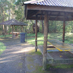
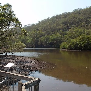
‘Berowra Valley Bushland Park’[23] is also known as Rosemead Rd Park and is found at the bottom end of Rosemead Rd[24], Hornsby. This is an open area park surrounded by shady eucalyptus trees[25], making a pleasant spot to rest on a walk. It has a picnic table with bench seats[26], and a sheltered free electric BBQ[27]. There is a water tap[28] in the park, near the road. There is also a ‘Welcome to Old Mans Valley’ information sign with information about the traditional country of the Darug and Guringai peoples[29].
(1.26km) Berowra Valley Bushland Park → Int of Blue Gum Walk and Joes Mountain Service Trail
890 m
20 mins
45m
-39m
Moderate track
Veer right: From the lower side of Berowra Valley Bushland Park[30] (at the end of Rosemead Rd, Hornsby[31]), this walk follows the ‘Fishponds 1.2km’ arrow on the large sign[32], down the track[33] for approximately 30m, to the intersection with the Rosemead management trail[34], marked with a Great North Walk arrow.
Veer right: From the intersection, this walk heads downhill along the wide rocky management trail[35] as it bends left (and passing some houses off to the left). The trail then bends right[36] and leads across Old Mans Creek using some concrete stepping stones[37]. The walk then continues by heading up the moderately steep hill and then through a thick blue gum and bracken fern forest[38]. The wide trail leads to the top of the hill then bends left, (ignoring the track on the right[39]) to pass over a saddle[40]. Here the trail leads down the gentle hill[41], through the turpentine forest for just over 300m to find an intersection with narrower track on the right, marked with arrow posts[42].
Veer right: From the intersection, this walk heads downhill along the wide rocky management trail[35] as it bends left (and passing some houses off to the left). The trail then bends right[36] and leads across Old Mans Creek using some concrete stepping stones[37]. The walk then continues by heading up the moderately steep hill and then through a thick blue gum and bracken fern forest[38]. The wide trail leads to the top of the hill then bends left, (ignoring the track on the right[39]) to pass over a saddle[40]. Here the trail leads down the gentle hill[41], through the turpentine forest for just over 300m to find an intersection with narrower track on the right, marked with arrow posts[42].
(2.15km) Int of Blue Gum Walk and Joes Mountain Service Trail → Fishponds Lookout
300 m
7 mins
0m
-39m
Moderate track
Veer right: From the intersection, the walk follows the ‘Great North Walk’ arrow[43] down the narrower track a short distance to find a three-way intersection marked with a large ‘Great North walk’ signpost[44].
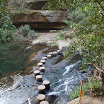
Continue straight: From the intersection, this walk follows the ‘Fishponds’ sign[45] along the flat narrow track past the ‘Berowra Valley Regional Park’ sign[46]. The track soon bends left (passing along the top of an unfenced cliff) then winds down some steep carved rock steps (with a hand rail)[47]. The rocky track then leads down along the side of the valley for just over 100m to cross a timber foot bridge[48]. The track then continues for another 70m to find a fenced rock platform[49] and signposted intersection[50].
Continue straight: From the intersection, this walk follows the ‘Fishponds’ sign[45] along the flat narrow track past the ‘Berowra Valley Regional Park’ sign[46]. The track soon bends left (passing along the top of an unfenced cliff) then winds down some steep carved rock steps (with a hand rail)[47]. The rocky track then leads down along the side of the valley for just over 100m to cross a timber foot bridge[48]. The track then continues for another 70m to find a fenced rock platform[49] and signposted intersection[50].
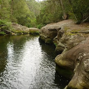
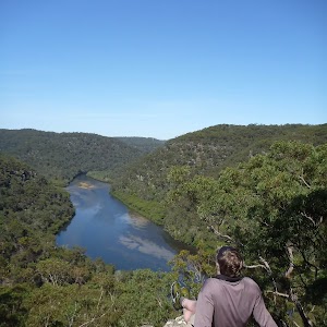
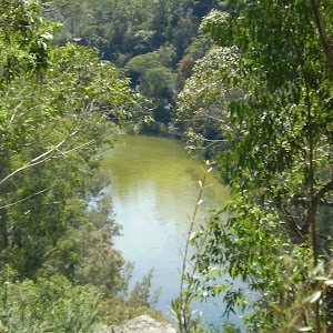
Fishponds Lookout
Fishponds Lookout is a fenced rock platform at the intersection of the Benowie walking track and the Rosemead trackhead. It is marked with a number of Great North Walk signs. This informally named lookout has good views down over Fishponds, a large waterhole on Berowra Creek. Looking north across the creek, there are views to the upper waterhole and the cliffs on the other side.
(2.45km) Fishponds Lookout → Fishponds Bridge
350 m
8 mins
16m
-14m
Moderate track
Turn right: From the lookout[51], this walk follows the ‘Galston Gorge’ sign[52] along the fenced rock shelf (keeping the fence to your left). The track leads down the rocky steps to the edge of Berowra Creek[53]. The walk crosses the creek using the stepping stones, and comes to a small cave[54] on the other side. This creek may be impassable after rain[55].
Veer right: From the cave, this walk follows the ‘Galston Gorge’ sign[56] up the track and timbers steps. Soon the track turns left and follows a Great North Walk arrow up the hill[57], at the red and white ‘Danger’ sign[58](ignoring the other track). The track climbs up the carved steps[59] onto the rock platform and continues up the rocky track until just after passing through a narrow gap between two rocks[60], where this walk comes to the un-signposted (and faint) intersection with the Pogson’s Trig track (on the left).
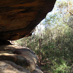
Continue straight: From the intersection, this walk heads down along the side of the hill[61], whilst keeping the main valley to your right. The track leads down some rocky steps, passing just above a rock platform (a short distance down on your right, with a plaque dedicated to ‘Cora’[62]). The track then leads down along the base of a cliff, passing under a rock overhang[63]. The track continues along the base of the cliff for another 50m then starts to wind downhill (with some handrails[64]) to come to a rock platform beside the creek[65]. This walk then crosses Berowra Creek on the flat timber bridge[66].
Veer right: From the cave, this walk follows the ‘Galston Gorge’ sign[56] up the track and timbers steps. Soon the track turns left and follows a Great North Walk arrow up the hill[57], at the red and white ‘Danger’ sign[58](ignoring the other track). The track climbs up the carved steps[59] onto the rock platform and continues up the rocky track until just after passing through a narrow gap between two rocks[60], where this walk comes to the un-signposted (and faint) intersection with the Pogson’s Trig track (on the left).
Continue straight: From the intersection, this walk heads down along the side of the hill[61], whilst keeping the main valley to your right. The track leads down some rocky steps, passing just above a rock platform (a short distance down on your right, with a plaque dedicated to ‘Cora’[62]). The track then leads down along the base of a cliff, passing under a rock overhang[63]. The track continues along the base of the cliff for another 50m then starts to wind downhill (with some handrails[64]) to come to a rock platform beside the creek[65]. This walk then crosses Berowra Creek on the flat timber bridge[66].
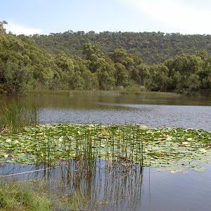
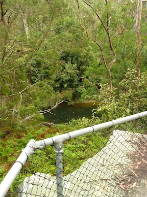
Fishponds
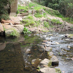
Fishponds is a long waterhole[67] on Berowra Creek in Berowra Valley Regional Park. The waterhole is lined with tall cliffs[68] and a few sandstone caves. At the southern end, there are stepping stones to help cross the creek[69], and a small timber bridge[70] at the northern end. This is a beautiful spot and a worthy place to rest and enjoy the water passing by[71]. The waterhole is fairly popular with local teens in summer, cooling off. Swimming and jumping at the Fishponds waterhole has resulted in fatalities – please heed the signs and Cora’s parents’ plea and enjoy the water from the edge.
Maps for the Hornsby to Fishponds walk
You can download the PDF for this walk to print a map.
These maps below cover the walk and the wider area around the walk, they are worth carrying for safety reasons.
| Hornsby | 1:25 000 Map Series | 91304S HORNSBY | NSW-91304S |
| Sydney | 1:100 000 Map Series | 9130 SYDNEY | 9130 |
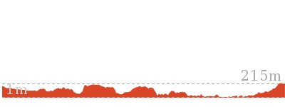
Cross sectional view of the Hornsby to Fishponds bushwalking track
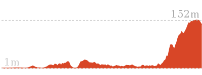
Analysis and summary of the altitude variation on the Hornsby to Fishponds
Overview of this walks grade – based on the AS 2156.1 – 2001
Under this standard, a walk is graded based on the most difficult section of the walk.
| Length | 5.6 km | ||
| Time | 2 hrs 30 mins | ||
| . | |||
| Grade 4/6 Hard track |
AS 2156.1 | Gradient | Very steep (4/6) |
| Quality of track | Formed track, with some branches and other obstacles (3/6) | ||
| Signs | Directional signs along the way (3/6) | ||
| Experience Required | Some bushwalking experience recommended (3/6) | ||
| Weather | Storms may impact on navigation and safety (3/6) | ||
| Infrastructure | Limited facilities, not all cliffs are fenced (3/6) |
Some more details of this walks Grading
Here is a bit more details explaining grading looking at sections of the walk
Gradient
1.2km of this walk has short steep hills and another 1km has gentle hills with occasional steps. Whilst another 350m is very steep and the remaining 180m is flat with no steps.
Quality of track
1.7km of this walk follows a clear and well formed track or trail and another 890m follows a formed track, with some branches and other obstacles. The remaining (180m) follows a smooth and hardened path.
Signs
Around 1.7km of this walk has directional signs at most intersection, whilst the remaining 1km is clearly signposted.
Experience Required
Around 2.1km of this walk requires no previous bushwalking experience, whilst the remaining 690m requires some bushwalking experience.
weather
Around 2.7km of this walk is not usually affected by severe weather events (that would unexpectedly impact safety and navigation), whilst the remaining 70m is affected by storms that may impact your navigation and safety.
Infrastructure
Around 1.9km of this walk is close to useful facilities (such as fenced cliffs and seats), whilst the remaining 890m has limited facilities (such as not all cliffs fenced).
Similar walks
A list of walks that share part of the track with the Hornsby to Fishponds walk.
4.2 km Circuit
2 hrs
Hard track
6.7 km Circuit
3 hrs
Hard track
9 km One way
3 hrs 45 mins
Hard track
9.7 km One way
4 hrs
Hard track
10.2 km One way
4 hrs
Hard track
15.5 km One way
6 hrs
Hard track
16.1 km One way
6 hrs 45 mins
Hard track
17.5 km One way
6 hrs 45 mins
Hard track
20.6 km One way
8 hrs
Hard track
22.3 km One way
9 hrs
Hard track
22.6 km One way
9 hrs 18 mins
Hard track
25.8 km One way
2 Days
Hard track
28.1 km One way
2 Days
Hard track
35.9 km One way
2 Days
Hard track
43.1 km One way
3 Days
Hard track
44.4 km One way
3 Days
Hard track
Other Nearby walks
A list of walks that start near the Hornsby to Fishponds walk.
8.6 km One way
3 hrs 45 mins
Hard track

499 m One way
15 mins
Easy track

6.5 km One way
2 hrs 30 mins
Hard track
14.7 km One way
5 hrs 30 mins
Hard track
1.4 km Return
30 mins
Moderate track
828 m Return
30 mins
Moderate track
515 m One way
15 mins
Moderate track
6.2 km One way
2 hrs 45 mins
Moderate track
3.4 km One way
1 hr 30 mins
Moderate track
6.1 km One way
2 hrs 30 mins
Hard track
6.6 km Circuit
2 hrs 30 mins
Hard track
619 m One way
30 mins
Moderate track
Plan your trip to and from the walk here
The Hornsby to Fishponds walk starts and ends at the Hornsby Train Station (gps: -33.703509, 151.09801)
Your transport options to Hornsby Train Station are by;
![]() Train. (get details)
Train. (get details)
![]() Bus. (get details)
Bus. (get details)
![]() Car. There is free parking available.
Car. There is free parking available.
(get details)
Short URL = http://wild.tl/htf
Gallery images
There are other downloads I am still working on.
You will probably need to login to access these — still all free.
* KML (google earth file)
* GPX (GPS file)
Special Maps/ brochures
* A3 topo maps
* PDF with Lands Topo map base
* PDF with arial image (and map overlay)
I wanted to get the main site live first, this extra stuff will come in time.
Happy walking
Matt 🙂
Cherrybrook to Thornleigh
And Walk
Cherrybrook to Thornleigh

1 hr 45 mins
4.4 km One way
128 m
Moderate track
This walk is mostly within the Berowra Valley Regional Park. It has some beautiful sections with great scenery, including sandstone rock features, lots of ferns and great scenery along Zig Zag creek. There is an optional side trip to visit the remnants of the historic Thornleigh Quarry and Zig Zag railway.


(0km) Top of The Lakes Of Cherrybrook park → Lakes trackhead
50 m
1 mins
0m
-4m
Very easy
From below 50 Shepherds Drive, opposite the shopping centre, the walk follows the concrete footpath into ‘The Lakes Of Cherrybrook’ park, keeping the playground to the right. The footpath comes to the signpost for ‘Callicoma Walk’ just before the unfenced lakes.
The Lakes Of Cherrybrook
The Lakes Of Cherrybrook is a park at the intersection of Shepherds Dr and Macquarie Dr, Cherrybrook. The lakes featured in the park were formed when the local creek was dammed for the benefit of farmers. The park has a free electric BBQ, sheltered picnic tables, taps and bubblers as well as a playground for the kids. There is a large shopping centre nearby. There are several signposted buswalks in the area, including the 5.1km ‘Callicoma Walk’ loop track.
(0.05km) Lakes trackhead → Int at stone wall
120 m
2 mins
1m
-4m
Very easy
Veer left: From the ‘Callicoma Walk’ signpost, the walk follows the ‘Sydney Cove’ arrow along the concrete footpath, keeping the lakes on the right. The walk passes a free BBQ and picnic shelters on the left, and a couple of viewing platforms on the right before coming to an intersection just before the road and beside a low handmade stone wall.
(0.17km) Int at stone wall → Int. of Blackwattle Trail and Callicoma Walk
180 m
3 mins
4m
-7m
Moderate track
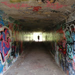
Turn right: From behind the low stone wall, the track follows the concrete footpath down the hill through the graffiti-covered tunnel, emerging in a clearing behind the ‘Cherrybrook Girl Guides’ building.
Veer right: From the clearing, the walk follows the bush track, initially keeping the Girl Guides hall on the left. The track passes a shortcut track on the right before coming to a ‘T’ intersection with a management trail marked with track arrows.
Veer right: From the clearing, the walk follows the bush track, initially keeping the Girl Guides hall on the left. The track passes a shortcut track on the right before coming to a ‘T’ intersection with a management trail marked with track arrows.
(0.35km) Int. of Blackwattle Trail and Callicoma Walk → Top of the Disturbed Creek stairs
230 m
4 mins
0m
-7m
Moderate track
Veer right: From the intersection, the walk follows the management trail down the hill, keeping the houses to the left, arriving at the signposted intersection at the top of the stairs (with a track on the right).
(0.59km) Top of the Disturbed Creek stairs → Int of Callicoma Walk and McKinley trail
170 m
3 mins
0m
-8m
Moderate track
Veer right: From the intersection, the walk goes down the steps towards the creek. Immediately after crossing the creek, on concrete stepping stones, the walk bends to the left, following the ‘Callicoma Walk’ arrow. The walk soon crosses some old concrete slabs and then drops down some more steps. After following the creek, on the left, for a short distance the walk comes to an intersection (with a management trail coming down the hill on the right).
(0.76km) Int of Callicoma Walk and McKinley trail → Int of Callicoma Walk and Disturbed Creek trail
100 m
2 mins
5m
-3m
Moderate track
Veer left: From the intersection, the walk follows the management trail down the hill, keeping the creek on the left and soon arrives at a fork intersection.
(0.85km) Int of Callicoma Walk and Disturbed Creek trail → Int of Callicoma Walk and Pogson Dr management trail
180 m
4 mins
13m
-6m
Moderate track
Veer right: From the intersection, the walk follows the bush track, keeping the creek on the left and immediately passes a ‘Callicoma Walk’ signpost. The walk continues along the well formed bush track and climbs steeply to an intersection marked with a ‘Callicoma Walk’ and red GNW signpost.
(1.04km) Int of Callicoma Walk and Pogson Dr management trail → Jungo campsite
610 m
13 mins
8m
-38m
Moderate track
Turn left: From the intersection, the walk follows the asphalted management trail up, over the hill, keeping the houses up to the right and soon arrives at an intersection marked with a ‘Callicoma Walk’ and red GNW track marker.
Turn left: From the intersection, the walk follows the ‘Callicoma Walk’ arrow down the management trail (no asphalt), keeping the power lines to the left. The walk descends steeply for a while then flattens out and soon comes to an intersection with the Great North Walk.
Continue straight: From the intersection, this walk follows the ‘Great North Walk’ sign[1][2] along the wide trail as it bends left and leads downhill along the concrete section[3]. The trail leads down across a usually small creek[4], then heads up to the well-signposted intersection[5] beside the Jungo campsite[6][7], where a ‘Fishponds’ sign[8] points back down along the trail.
The Jungo
The Jungo is a relatively small clearing and campsite near the junction of Berowra and ZigZag Creeks at a well signposted intersection[9]. There is often water in the creeks (treat well before drinking) but there are no facilities[10]. Speculation on the source of the name ‘Jungo’ includes the Aussie tendency to abbreviate words (‘Junction’ gets corrupted to ‘jung-o’ etc) as well as a possible derivation from one of a few similar sounding aboriginal words.
(1.65km) The Jungo → Zig Zag Creek Bridge intersection
1.4 km
25 mins
37m
-16m
Moderate track
Veer left: From the intersection at the Jungo, this walk follows the ‘Bellamy Street’ Great North Walk sign[11] through the campsite and along the pleasant track, leading into, then through, the ferny forest[12] for about 700m before crossing a side creek on a timber bridge[13]. The track then continues in a similar manner for another 700m, coming to a T-intersection with a concrete bike track, beside a large bridge (over Zigzag Creek, on your left) where a sign points back along the ‘Great North Walk’[14].
(3.08km) Zig Zag Creek Bridge int → Thornleigh Quarry
160 m
4 mins
15m
-8m
Moderate track
Turn sharp left: From the intersection, the walk heads gently downhill to then cross ‘Zig Zag Creek’[15] on the 40m long bridge[16] (with handrails) to find the ‘Zig Zag Siding’ information sign[17][18] on the far side. The bridge path now merges back to the main wide trail[19] and heads steeply uphill[20] for about 50m
(with a handrail on the left side[21]). The trail then mostly flattens out for about 50m and leads gently up to the front of the old ‘Thornleigh Quarry’[22], marked with a plaque on a large stone[23][24][25]
. At the end of this side trip, retrace your steps back to the main walk then Continue straight.
Thornleigh zigzag railway
The Thornleigh zigzag railway originally ran from the main rail line near Thornleigh to a historic quarry, near present day De Saxe Cl, Thornleigh. There are only minor fragments still visible today. The ‘Heritage Trail’ in Thornleigh has interpretive signs for the railway and the old Thornleigh Quarry. A book is available with some detail on railway and associated quarry: ‘Sydney’s Forgotten Quarry Railways’ by John Oakes, ISBN 0 9757870 3 9
Old Thornleigh Quarry
The old Thornleigh Quarry[26] is located beside the Heritage Trail in Thornleigh, within Berowra Valley Regional Park. The quarry dates back to 1883 and was initially a source of ‘ballast’ for portions of the Sydney (Homebush) to Newcastle (Waratah) rail link. There is a firm, flat dirt track[27] that leads about 40m from the concrete trail to the centre of the old quarry[28]. You will find a series of log seats in this amphitheatre
making this a pleasant spot to sit and enjoy the intriguing mix of nature and history. A book is available with some detail on this quarry and the associated zigzag railway: ‘Sydney’s Forgotten Quarry Railways’ by John Oakes, ISBN 0 9757870 3 9
(3.08km) Zig Zag Creek Bridge int. → Int of Bellamy trail and Morgan Rd tracks
130 m
2 mins
6m
0m
Easy track
Turn right: From the intersection, this walk follows the concrete trail uphill[29], directly away from ‘Zig Zag Creek’[30]. The walk continues up out of the valley[31] along the concrete trail for 110m to cross over the culverted creek[32] (with a green rail[33] on one side)
. Just 25m past this culvert the walk comes to an intersection (with a dirt track on the left) marked with a few signs including a ‘The Jungo’ arrow[34] point back down along the trail.
(3.21km) Int of Bike Trail and Morgan Rd tracks → Morgan Rd
230 m
4 mins
7m
-3m
Moderate track
Turn left: From the intersection, this walk follows the ‘Sydney Cove’ sign[35] along the narrow track away from the wide concrete trail. The track leads behind the house (on your right) following along the rocky side of Zig Zag Creek[36]. After the third house, in a small clearing, the track turns right[37], heading up between the houses[38] a short distance to come to the top of the turning circle[39] at the end of Morgan Road, Thornleigh.
(3.44km) Morgan Rd → Thornleigh Train Station
990 m
18 mins
47m
-7m
Easy track
Turn left: From the end of Morgan Street, this walk heads up along the road[40] to left into ‘Tillock Street’[41]. This street soon bends right[42] to become ‘Eddy Street’[43] following the footpath[44] and GNW arrows[45] to the top of the hill where there is a set of traffic lights[46]. The walk cross ‘The Esplanade’ at the lights[47] to then turn right walking past the car park[48], and through a small park[49] to find a large ‘Great North Walk’ sign[50] at the (north bound) entrance to Thornleigh train station[51].
Maps for the Cherrybrook to Thornleigh walk
You can download the PDF for this walk to print a map.
These maps below cover the walk and the wider area around the walk, they are worth carrying for safety reasons.
| Hornsby | 1:25 000 Map Series | 91304S HORNSBY | NSW-91304S |
| Sydney | 1:100 000 Map Series | 9130 SYDNEY | 9130 |
Cross sectional view of the Cherrybrook to Thornleigh bushwalking track
Analysis and summary of the altitude variation on the Cherrybrook to Thornleigh
Overview of this walks grade – based on the AS 2156.1 – 2001
Under this standard, a walk is graded based on the most difficult section of the walk.
| Length | 4.4 km | ||
| Time | 1 hr 45 mins | ||
| . | |||
| Grade 3/6 Moderate track |
AS 2156.1 | Gradient | Short steep hills (3/6) |
| Quality of track | Formed track, with some branches and other obstacles (3/6) | ||
| Signs | Directional signs along the way (3/6) | ||
| Experience Required | Some bushwalking experience recommended (3/6) | ||
| Weather | Storms may impact on navigation and safety (3/6) | ||
| Infrastructure | Limited facilities, not all cliffs are fenced (3/6) |
Some more details of this walks Grading
Here is a bit more details explaining grading looking at sections of the walk
Gradient
2.2km of this walk has short steep hills and another 1.2km is flat with no steps. The remaining (1km) has gentle hills with occasional steps.
Quality of track
3.6km of this walk follows a clear and well formed track or trail and another 410m follows a formed track, with some branches and other obstacles. The remaining (400m) follows a smooth and hardened path.
Signs
Around 2.8km of this walk has directional signs at most intersection, whilst the remaining 1.6km is clearly signposted.
Experience Required
Around 3.4km of this walk requires no previous bushwalking experience, whilst the remaining 1.1km requires some bushwalking experience.
weather
Around 4.2km of this walk is not usually affected by severe weather events (that would unexpectedly impact safety and navigation), whilst the remaining 270m is affected by storms that may impact your navigation and safety.
Infrastructure
Around 3.1km of this walk has limited facilities (such as not all cliffs fenced), whilst the remaining 1.4km is close to useful facilities (such as fenced cliffs and seats).
Similar walks
A list of walks that share part of the track with the Cherrybrook to Thornleigh walk.
439 m Circuit
15 mins
Moderate track
529 m One way
15 mins
Moderate track
619 m One way
30 mins
Moderate track
2.2 km One way
1 Hr
Moderate track
4.1 km One way
1 hr 45 mins
Moderate track
4.2 km Circuit
1 hr 45 mins
Hard track
5.1 km Circuit
2 hrs
Hard track
6.6 km Circuit
2 hrs 30 mins
Hard track
8.6 km One way
3 hrs 45 mins
Hard track
9 km One way
3 hrs 45 mins
Hard track
10.2 km One way
4 hrs
Hard track
15.5 km One way
6 hrs
Hard track
17.5 km One way
6 hrs 45 mins
Hard track
20.6 km One way
8 hrs
Hard track
25.8 km One way
2 Days
Hard track
28.1 km One way
2 Days
Hard track
35.9 km One way
2 Days
Hard track
44.4 km One way
3 Days
Hard track
Other Nearby walks
A list of walks that start near the Cherrybrook to Thornleigh walk.
2.5 km Return
1 hr 30 mins
Hard track
515 m One way
15 mins
Moderate track
828 m Return
30 mins
Moderate track
1.4 km Return
30 mins
Moderate track
6.1 km One way
2 hrs 30 mins
Hard track
8.2 km Circuit
3 hrs
Hard track
717 m Circuit
20 mins
Very easy
14.7 km One way
5 hrs 30 mins
Hard track
4.2 km Circuit
2 hrs
Hard track
6.7 km Circuit
3 hrs
Hard track
16.1 km One way
6 hrs 45 mins
Hard track
43.1 km One way
3 Days
Hard track
Plan your trip to and from the walk here
The Cherrybrook to Thornleigh walk starts at the Top of The Lakes Of Cherrybrook park (gps: -33.721735, 151.04418)
Your transport options to Top of The Lakes Of Cherrybrook park are by;
![]() Bus. (get details)
Bus. (get details)
![]() Car. There is free parking available.
Car. There is free parking available.
(get details)
The Cherrybrook to Thornleigh ends at the Thornleigh Train Station (gps: -33.731949, 151.07815)
Your transport options to Thornleigh Train Station are by;
![]() Train. (get details)
Train. (get details)
![]() Bus. (get details)
Bus. (get details)
![]() Car. There is free parking available.
Car. There is free parking available.
(get details)
Short URL = http://wild.tl/ctt
Gallery images
There are other downloads I am still working on.
You will probably need to login to access these — still all free.
* KML (google earth file)
* GPX (GPS file)
Special Maps/ brochures
* A3 topo maps
* PDF with Lands Topo map base
* PDF with arial image (and map overlay)
I wanted to get the main site live first, this extra stuff will come in time.
Happy walking
Matt 🙂
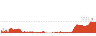
Thornleigh to Galston Gorge
And Walk
Thornleigh to Galston Gorge

6 hrs
15.5 km One way
768 m
Hard track
This walk follows the Great North Walk above Berowra Creek from Thornleigh to Galston Gorge, on bush tracks and service trails. The Steele Bridge is quite an interesting landmark of the area. Fishponds is a wonderful highlight, it is a lovely water hole surrounded by tall sandstone cliffs. The walk finishes on a road a long way from anywhere, you will need to organise a friend to pick you up.
Note this walk was re-routed in early 2016 to go via the streets of Hornsby Heights. This re-route is due to the multi-agency decision to close the Fishponds to Steele Bridge section of the Benowie Track. This decision has upset many people and the protest continues.


(0km) Thornleigh Train Station → Morgan Rd
990 m
18 mins
7m
-47m
Easy track
From the western (north bound) side of Thornleigh Station[1], this walk follows the ‘Jungo Rest Area’ sign[2] along the footpath towards the car park and The Esplanade[3]. The walk then heads down a short distance further to turn left and cross ‘The Esplanade’ at the traffic lights[4], then continue straight along the footpath down along Eddy Rd[5]. Following a couple of GNW arrows[6] down Eddy Rd as it then bends left[7], turning into Tilock St, and shortly later this walk then turns right into Morgan St[8]. Continuing down till just before the end of this street[9][10], this walk comes to an intersection marked with a GNW arrow[11] and the ‘Elouera Bushland Natural Park’ sign[12] (on the right).
(0.99km) Morgan Rd → Int of Bike Trail and Morgan Rd tracks
230 m
4 mins
3m
-7m
Moderate track
Turn right: From the end of Morgan Street, the walk follows the GNW arrow[13] and the ‘Elouera Bushland Natural Park’ sign[14] between houses[15] no. 28 and 26. Once behind the houses at a small clearing[16], the track turns left and follows down the rocky side of Zig Zag Creek[17]. Soon after passing behind the third house, the track comes to an intersection with a wide concrete trail[18], where a sign points back along the track to ‘Sydney Cove’[19].
(1.22km) Int of Bellamy trail and Morgan Rd tracks → Zig Zag Creek Bridge int.
130 m
2 mins
0m
-6m
Easy track
Turn right: From the intersection, this walk follows the ‘The Jungo’ arrow[20] downhill along the wide concrete trail for 25m to cross over the culverted creek[21] (with a green rail[22] on one side)
. The walk continues down into the valley[23] along the concrete trail for another 110m to come to a signposted intersection marked with a ‘Great North Walk’ sign[24][25] (on your left), just before ‘Zig Zag Creek’[26] and the long bridge[27].
Thornleigh zigzag railway
The Thornleigh zigzag railway originally ran from the main rail line near Thornleigh to a historic quarry, near present day De Saxe Cl, Thornleigh. There are only minor fragments still visible today. The ‘Heritage Trail’ in Thornleigh has interpretive signs for the railway and the old Thornleigh Quarry. A book is available with some detail on railway and associated quarry: ‘Sydney’s Forgotten Quarry Railways’ by John Oakes, ISBN 0 9757870 3 9
(1.34km) Zig Zag Creek Bridge intersection → The Jungo
1.4 km
25 mins
16m
-37m
Moderate track
Turn left: From the intersection, this walk follows the ‘Great North Walk’ sign[28] along the narrower track, keeping the gully to your right. The pleasant track leads into, then through, the ferny forest[29] with tall trees for about 700m, before crossing a side creek on a timber bridge[30]. The track then continues in a similar manner for another 700m, coming to a large clearing and campsite[31], The Jungo. On the far side of this clearing is a well-signposted intersection with a ‘Bellamy Street’ sign[32] pointing back through the campsite.
The Jungo
The Jungo is a relatively small clearing and campsite near the junction of Berowra and ZigZag Creeks at a well signposted intersection[33]. There is often water in the creeks (treat well before drinking) but there are no facilities[34]. Speculation on the source of the name ‘Jungo’ includes the Aussie tendency to abbreviate words (‘Junction’ gets corrupted to ‘jung-o’ etc) as well as a possible derivation from one of a few similar sounding aboriginal words.
(2.78km) Jungo campsite → Int of GNW and Stringybark Ridge trail
100 m
2 mins
1m
0m
Moderate track
Veer right: From the campsite, this walk follows the ‘Fishponds’ sign[35] down across the concrete ford, over the usually small creek[36]. Here, the concrete management trail[37] leads uphill, becoming dirt as it starts to flatten out[38]. This walk then comes to a signposted intersection[39] of the ‘Great North Walk’[40] and the Stringybark Ridge management trail (signposted ‘Cherrybrook Lakes’ trail[41]).
(2.88km) Int of GNW and Stringybark Ridge trail → Elouera Lookout
1 km
27 mins
81m
-58m
Moderate track
Turn right: From the intersection, this walk follows the ‘Great North Walk’ sign[42] down the narrower track. The track leads downhill for about 70m, getting steeper[43] as it goes, and then crosses Berowra Creek[44] – this creek may become impassable after rain. On the other side, the walk comes to an intersection on a small sandy beach. Here, the walk turns left, following the GNW arrows downstream for about 250m among the grass trees and crossing a flat timber bridge[45]. The rocky track then continues for just shy of 250m and crosses a mossy gully on a large flat rock[46]. The track then continues, staying fairly flat[47] for another 170m before bending right and heading steeply uphill[48]. At the top of this climb, the track soon leads to a section of fenced cliff[49]. At the end of the fence, the walk passes through casuarina forest[50] for a short distance before passing alongside another (longer) fenced cliff and coming to the Elouera Lookout[51], where there is an intersection with the ‘Westleigh’ track[52] (on your right).
Elouera Lookout
This fenced lookout is on the Benowie Track close to Westleigh. There are uninterrupted views from the clifftop across the Berowra Creek valley, which is rare for the area[53]. As well as being on the Great North Walk, this lookout can be accessed by a short walk from Elouera Rd, Westleigh. This section of fenced rock platform is about 100m long[54], and there is some limited shade[55] from the casuarina near the lookout if you want to take a rest.
(3.93km) Elouera Lookout → Int of the Great North Walk and the Quarter Sessions Road track
2.2 km
54 mins
152m
-130m
Moderate track
Continue straight: From Elouera Lookout[56], this walk follows the ‘Great North Walk’ sign[57] along the track, keeping the fence and valley to your left[58]. At the end of the fence, the walk bends left following the rocky flat track for about 200m, where the track then becomes progressively steeper for about 250m, winding steeply down then across a flat timber bridge[59]. From here, the track leads beside Berowra Creek[60] for a short time before crossing another flat timber bridge[61]. The track then passes among the pleasant grass trees for about 200m (crossing a couple of small creeks with timber plank spans[62]) to then climb a few sets of timber steps and cross a small (often dry) creek[63]. From here, the track gently winds up along the side of the hill for about 800m, passing through a pleasant casuarina forest[64] then heading across a rocky creek on another small, flat, timber bridge[65]. Just over 100m later, the track crosses a smaller (often dry) creek[66] to then wind uphill for about 100m to a three-way intersection with the signposted ‘Quarter Sessions Rd’ track[67] (on your right).
(6.08km) Int of the Great North Walk and the Quarter Sessions Road track → Int of the Great North Walk and the Blackfellows Head lookout track
620 m
16 mins
36m
-64m
Moderate track
Veer left: From the intersection, this walk heads north along the main rocky track, keeping the valley down to your left. The track leads along beside a rock wall (which is on your right) and through a rock outcrop[68], where the track soon heads quite steeply uphill along the eroded track[69] for a short time. At the top of this steep section, the rocky track continues to meander much more gently up along the side of the hill[70] for about 300m, then crosses a small, rocky gully[71], just below some houses[72]. The track then continues gently uphill for about 100m to an intersection with the unsignposted Blackfellows Head track[73] (on your right).
(6.7km) Int of the Great North Walk and the Blackfellows Head lookout track → Int of the Great North Walk and the Blue Gum Walk (SW)
80 m
2 mins
7m
-9m
Moderate track
Continue straight: From the intersection, this walk heads north along the clear track, keeping the valley down to your left for about 100m, where the walk comes to a three-way intersection and ‘The Jungo’ sign[74] points back along the track.
(6.77km) Int of the Great North Walk and the Blue Gum Walk (SW) → Fishponds Lookout
990 m
21 mins
21m
-87m
Hard track
Veer left: From the intersection, this walk follows the ‘Fishponds’ sign[75] past the ‘Berowra Valley Regional Park’ sign[76], gently uphill along the narrow ridge[77]. The track is mostly flat for about 200m before it starts to head fairly steeply down over some rocks[78] and down a set of rock steps[79]. This area comes alive with Patersonia lilies and pink wax flowers in early spring. The track then continues fairly gently down along the narrow ridge[80] for another 200m before leading through a crack in a rock, then down a bit further to climb down through a particularly steep rocky section[81]. Near the bottom of this descent, this walk passes a couple of arrow posts[82], where the track bends right to pass below a large rock overhang[83]. Just beyond this overhang, the track bends left and leads across Waitara Creek at the interesting holes in the rock know as ‘the spa’[84]. This creek may become impassable after heavy rain, the rocks can also be slippery. Across the creek, the walk comes to a large rock platform and a Blue Gum Track post[85].
After stopping to enjoy cool spot, this walk continues left along the unfenced rock platform[86] (keeping the creek down to your left). The walk soon steps off this large rock (at the far right-hand corner, through the fork in a tree[87]). This walk heads over another rock platform[88], then along a notably flat section of track[89] (now with Berowra Creek on your left), passing beside some cascades[90] for about 100m before climbing up and over some rocks and under a sandstone overhang[91]. The track leads around the side of the hill for about 100m, then down to cross a small creek using the small flat timber bridge[92]. The walk then climbs up some timber steps[93] to a fenced lookout[94] over Fishponds, at a well-signposted intersection[95]. A sign points back along the track to ‘Thornleigh Station’[96].
After stopping to enjoy cool spot, this walk continues left along the unfenced rock platform[86] (keeping the creek down to your left). The walk soon steps off this large rock (at the far right-hand corner, through the fork in a tree[87]). This walk heads over another rock platform[88], then along a notably flat section of track[89] (now with Berowra Creek on your left), passing beside some cascades[90] for about 100m before climbing up and over some rocks and under a sandstone overhang[91]. The track leads around the side of the hill for about 100m, then down to cross a small creek using the small flat timber bridge[92]. The walk then climbs up some timber steps[93] to a fenced lookout[94] over Fishponds, at a well-signposted intersection[95]. A sign points back along the track to ‘Thornleigh Station’[96].
Fishponds Lookout
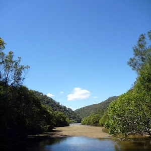
Fishponds Lookout is a fenced rock platform at the intersection of the Benowie walking track and the Rosemead trackhead. It is marked with a number of Great North Walk signs. This informally named lookout has good views down over Fishponds, a large waterhole on Berowra Creek. Looking north across the creek, there are views to the upper waterhole and the cliffs on the other side.
(7.76km) Fishponds Lookout → Fishponds crossing
70 m
2 mins
3m
-4m
Moderate track
Continue straight: From the lookout[97], this walk follows the ‘Galston Gorge’ sign[98] along the fenced rock shelf (keeping the fence to your left). The track leads down the rocky steps to the edge of Berowra Creek[99]. The walk crosses the creek using the stepping stones, and comes to a small cave[100] on the other side. This creek may be impassable after rain[101]. At the end of this side trip, retrace your steps back to the main walk then Turn left.
Fishponds
Fishponds is a long waterhole[102] on Berowra Creek in Berowra Valley Regional Park. The waterhole is lined with tall cliffs[103] and a few sandstone caves. At the southern end, there are stepping stones to help cross the creek[104], and a small timber bridge[105] at the northern end. This is a beautiful spot and a worthy place to rest and enjoy the water passing by[106]. The waterhole is fairly popular with local teens in summer, cooling off. Swimming and jumping at the Fishponds waterhole has resulted in fatalities – please heed the signs and Cora’s parents’ plea and enjoy the water from the edge.
(7.76km) Fishponds Lookout → Corner of Dilkera and Manor Rd
500 m
19 mins
131m
0m
Moderate track
Turn right: From the lookout, this walk follows the ‘Rosemead Rd Trackhead’ sign[108] directly away from the view over Berowra Creek. After about 70m, the track leads over a timber footbridge[109], then leads up the side of the valley for about 100m to climb up the steep carved rock steps (with a hand rail)[110]. Here the track leads along the top of this unfenced cliff and soon comes to a well signposted three-way intersection, where a ‘Fishponds’ sign[111] points back along the track.
Veer left: From the intersection, this walk follows the ‘Alternative Route’ arrow on the GNW sign[112]. The track dips before heading steeply uphill, zigzagging in several sections. The walk leads you up a large metal staircase to the top of the cliffs, coming to the intersection of Manor Rd and Dilkera Cl.
Veer left: From the intersection, this walk follows the ‘Alternative Route’ arrow on the GNW sign[112]. The track dips before heading steeply uphill, zigzagging in several sections. The walk leads you up a large metal staircase to the top of the cliffs, coming to the intersection of Manor Rd and Dilkera Cl.
(8.26km) Corner of Dilkera and Manor Rd → End of Clarinda St
1.7 km
31 mins
36m
-49m
Easy track
Continue straight: From the intersection, this walk follows Manor Rd as it initially heads up a gentle hill. After about 600m, Manor Road turns to skirt about Mount Wilga Hospital, and the road changes name to Rosamond St. The walk continues along to the intersection with Stewart Ave on the left (this is a four-way intersection, with Carrington Rd on the right).
Continue straight: From the intersection, this walk heads north along Rosamond St following the Great North Walk arrow. The walk then turns left into Clarinda St and follows it to the end of the road, to find the ‘Clarinda Wetlands’ sign.
Continue straight: From the intersection, this walk heads north along Rosamond St following the Great North Walk arrow. The walk then turns left into Clarinda St and follows it to the end of the road, to find the ‘Clarinda Wetlands’ sign.
(9.91km) End of Clarinda St → Int of Clarinda St trail and waterfall track
1.1 km
24 mins
51m
-66m
Easy track
Turn right: From the end of Clarinda St Hornsby, this walk heads around the green gate with the ‘Berowra Valley Regional Park’ sign on it, keeping the ‘Clarinda wetlands’ to the left. The walk follows the management trail, which soon bends left and gently winds through the bushland. There are some interesting rock formations on the right and the occasional valley view on the left. The track is fairly flat most of the way, until a left-hand bend that leads down to cross a small creek, and then up the other side of the valley. Once the track flattens out again, it comes to an intersection with the Simon Pl management trail on the right, at a fairly large clearing.
Continue straight: From the intersection, this walk follows the flat management trail, heading away from Simon Place past the ‘Berowra Valley Regional Park’, ‘Dogs Prohibited’ sign[113]. The walk gently meanders along the trail, enjoying the ferns and sandstone rocks for a while until coming to a ‘Great North Walk’ sign[114] highlighting the intersection with small track on the left.
Continue straight: From the intersection, this walk follows the flat management trail, heading away from Simon Place past the ‘Berowra Valley Regional Park’, ‘Dogs Prohibited’ sign[113]. The walk gently meanders along the trail, enjoying the ferns and sandstone rocks for a while until coming to a ‘Great North Walk’ sign[114] highlighting the intersection with small track on the left.
(10.99km) Int of Clarinda St and waterfall track → Int of Stewart Ave service trail and waterfall track
470 m
13 mins
9m
-98m
Moderate track
Turn left : From the intersection, this walk heads down the hill along the narrow track, following the ‘Great North Walk’ sign[115]. The track is rocky and steep in a few places. Take care as the track turns at the top of some smaller cliffs while winding down the hill. Steps have been made from rocks and logs, making this track a bit more gentle, and there are some carved steps in the steeper sections. At the bottom of a small flight stone stairs, the walk crosses the creek on the rocks just in front of the waterfall.
Veer right: From the waterfall, this walk climbs the stone stairs (keeping the waterfall initially on the left) and then turns right, heading up out of the gully. Once at the top of the stairs, the walk heads through the bush until soon coming to a ‘T’ intersection with the Stewart St management trail, signposted with a large ‘Great North Walk’ sign[116].
Veer right: From the waterfall, this walk climbs the stone stairs (keeping the waterfall initially on the left) and then turns right, heading up out of the gully. Once at the top of the stairs, the walk heads through the bush until soon coming to a ‘T’ intersection with the Stewart St management trail, signposted with a large ‘Great North Walk’ sign[116].
(11.46km) Int of Stewart Ave service trail and waterfall track → Steele Bridge
400 m
8 mins
5m
-29m
Easy track
Turn right: From the intersection, this walk follows the ‘Galston Gorge 4km’ arrow[117] down the hill along the wide management trail. For the most part, the trail gently heads downhill then bends around to the left, leading to an intersection just before Steele Bridge.
Historic Military ‘Steele’ Bridge
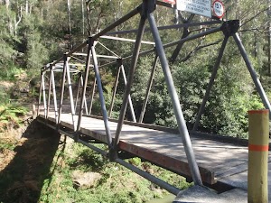
This large steel and timber bridge spans Berowra Creek north of Fishponds. The creek is fairly wide at this point and the bridge provides a great view of the sandstone overhangs along the creek’s edge. The bridge was commissioned in 1965 to allow access for fire trucks. The bridge was designed by Major General Sir Clive Steele in 1942. Bridges of this type were critical during the WWII South West Pacific campaigns. The bridge is designed on the Warren truss style and is one of only 4 ‘Steele’ bridges still in use in NSW. More info.
(11.86km) Steele Bridge → Tunks Ridge Rest Area
1.8 km
44 mins
160m
-33m
Hard track
Veer right: From the intersection, this walk crosses the ‘Historic Military Steele Bridge’[118] and turns right to follow the ‘Crosslands’ sign [119] uphill along the wide management trail. After about 200m, the trail becomes steeper (and is concreted) for around 150m, then flattens out just before the left bend. The trail continues to climb (enjoying the valley views to the right) for another 400m, after which the trail becomes quite steep again for for about 600m (here the trail is sealed[120] then concreted[121] in two sections). From the top of the second concreted section, the trail leads gently uphill for just shy of 300m to the well-signposted ‘Tunks Ridge Rest Area’, where a sign points back down the trail to ‘Stewart St Hornsby Trackhead’[122].
Tunks Ridge Rest Area
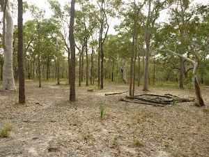
Tunks Ridge Rest Area is a large, shady and gently sloping campsite[123] at the junction of three management trails. There is no water or other facilities (you will need to carry your own in). A sign at the top of the campsite reminds campers that there is a one night limit and that it is a fuel stove only area (no campfires)[124]. Please note that the composting toilet[125] has been removed and no longer available.
(13.63km) Tunks Ridge Rest Area → Int of Great North Walk and Galston Gorge track
1.4 km
28 mins
38m
-68m
Moderate track
Turn right: From the top of the rest area, this walk follows the ‘Galston Gorge’ AND ‘Crosslands Reserve’ signs[126] along the wide management trail, keeping the valley to your right. The trail winds along the side of the ridge[127] (passing along the base of a long rock wall[128], up to your left) for about 700m, until the trail comes to the top of the ridge. From here, the trail leads for another 500m, down across a saddle[129] then up to a clear Y-intersection[130]. The walk takes the left branch and passes a few ‘Regeneration Area’ signs[131][132] over about 250m, coming to a well-signposted[133] intersection with narrower track (on your left), partway around the right-hand bend.
Top of Galston Gorge Campsite
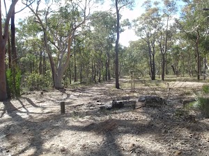
This campsite can be found on the Great North Walk, off the service trail just before it descends into Galston Gorge (when coming from the south). There is plenty of room for a group of tents, however there is no available water or facilities. Although this is an official campsite for the Great North Walk, there are some threatened species in the area, therefore Tunks Ridge Reserve (1.4km South) would make a better alternative, with better facilities.
(14.99km) Int of Great North Walk and Galston Gorge track → Galston Gorge track head
550 m
16 mins
14m
-119m
Hard track
Turn left: From the intersection, the walk follows the ‘Galston Gorge’ sign[134] down the steep rocky track[135] as it zigzags down towards the valley. About 40m down the hill, the track comes to a ‘Great North Walk – Walkers Registration’ box[136]. After leaving your comments, this walk continues downhill, passing through a crack in the rock[137] where the walk bends right and follows along the particularly rocky section for about 150m and comes to a fence[138]. The fence guides down a steep section, passing a cave[139], and comes to the top of a metal peg ladder[140]. This walk climbs down the ladder, then follows the rock wall (keeping the road to your left), heading down through a crack[141] and along another fence, then coming to a flat area beside the road[142]. Here the walk follows the GNW arrow[143] to the right and down under the bridge[144]. The walk crosses the creek, usually a bit more than ankle deep[145]. This creek maybe impassable after rain – the road bridge above offers an alternate way across[146], but watch and listen for traffic. On the other bank, the walk turns left to follow the track uphill[147]. The track well-formed track climbs to the well-signposted and paved Galston Gorge trackhead[148], where a ‘Fishponds’ sign[149] points back down the track.
Galston Gorge track head
Galston Gorge track head is located at a small car park[150] on the eastern side of Berowra Creek, near the bottom of the gorge on Galston Road. This track head is a good access point for those wanting to do sections of the Great North Walk and is well signposted[151]. Keep an eye open for the local chickens[152].
Maps for the Thornleigh to Galston Gorge walk
You can download the PDF for this walk to print a map.
These maps below cover the walk and the wider area around the walk, they are worth carrying for safety reasons.
| Hornsby | 1:25 000 Map Series | 91304S HORNSBY | NSW-91304S |
| Sydney | 1:100 000 Map Series | 9130 SYDNEY | 9130 |
Cross sectional view of the Thornleigh to Galston Gorge bushwalking track
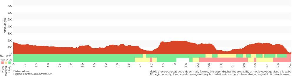
Analysis and summary of the altitude variation on the Thornleigh to Galston Gorge
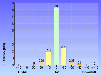
Overview of this walks grade – based on the AS 2156.1 – 2001
Under this standard, a walk is graded based on the most difficult section of the walk.
| Length | 15.5 km | ||
| Time | 6 hrs | ||
| . | |||
| Grade 4/6 Hard track |
AS 2156.1 | Gradient | Very steep (4/6) |
| Quality of track | Formed track, with some branches and other obstacles (3/6) | ||
| Signs | Directional signs along the way (3/6) | ||
| Experience Required | Moderate level of bushwalking experience recommended (4/6) | ||
| Weather | Storms may impact on navigation and safety (3/6) | ||
| Infrastructure | Limited facilities, not all cliffs are fenced (3/6) |
Some more details of this walks Grading
Here is a bit more details explaining grading looking at sections of the walk
Gradient
6km of this walk has short steep hills and another 3.8km has gentle hills with occasional steps. Whilst another 3.3km is very steep and the remaining 2.2km is flat with no steps.
Quality of track
7km of this walk follows a clear and well formed track or trail and another 6km follows a formed track, with some branches and other obstacles. The remaining (1.9km) follows a smooth and hardened path.
Signs
Around 8km of this walk has directional signs at most intersection, whilst the remaining 7km is clearly signposted.
Experience Required
9km of this walk requires no previous bushwalking experience and another 5km requires some bushwalking experience. The remaining (990m) requires a leader a with moderate level of bushwalking experience.
weather
Around 15km of this walk is not usually affected by severe weather events (that would unexpectedly impact safety and navigation), whilst the remaining 990m is affected by storms that may impact your navigation and safety.
Infrastructure
Around 8km of this walk has limited facilities (such as not all cliffs fenced), whilst the remaining 7km is close to useful facilities (such as fenced cliffs and seats).
Similar walks
A list of walks that share part of the track with the Thornleigh to Galston Gorge walk.
499 m One way
15 mins
Easy track
529 m One way
15 mins
Moderate track
619 m One way
30 mins
Moderate track
4.2 km Circuit
2 hrs
Hard track
4.2 km Circuit
1 hr 45 mins
Hard track
4.4 km One way
1 hr 45 mins
Moderate track
5.1 km Circuit
2 hrs
Hard track
5.6 km Return
2 hrs 30 mins
Hard track
6.6 km Circuit
2 hrs 30 mins
Hard track
6.7 km Circuit
3 hrs
Hard track
8.6 km One way
3 hrs 45 mins
Hard track
9 km One way
3 hrs 45 mins
Hard track
9.7 km One way
4 hrs
Hard track
10.2 km One way
4 hrs
Hard track
16.1 km One way
6 hrs 45 mins
Hard track
17.5 km One way
6 hrs 45 mins
Hard track
20.6 km One way
8 hrs
Hard track
22.3 km One way
9 hrs
Hard track
22.6 km One way
9 hrs 18 mins
Hard track
25.8 km One way
2 Days
Hard track
28.1 km One way
2 Days
Hard track
35.9 km One way
2 Days
Hard track
43.1 km One way
3 Days
Hard track
44.4 km One way
3 Days
Hard track
Other Nearby walks
A list of walks that start near the Thornleigh to Galston Gorge walk.
6.1 km One way
2 hrs 30 mins
Hard track
8.2 km Circuit
3 hrs
Hard track
717 m Circuit
20 mins
Very easy
2.5 km Return
1 hr 30 mins
Hard track
828 m Return
30 mins
Moderate track
4.1 km One way
1 hr 45 mins
Moderate track
439 m Circuit
15 mins
Moderate track
2.2 km One way
1 Hr
Moderate track

516 m Return
15 mins
Moderate track
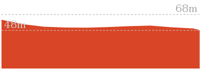
2.8 km Return
1 Hr
Moderate track
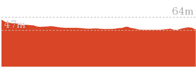
3.2 km Return
1 hr 30 mins
Moderate track
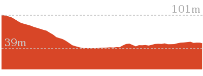
Plan your trip to and from the walk here
The Thornleigh to Galston Gorge walk starts at the Thornleigh Train Station (gps: -33.731949, 151.07815)
Your transport options to Thornleigh Train Station are by;
![]() Train. (get details)
Train. (get details)
![]() Bus. (get details)
Bus. (get details)
![]() Car. There is free parking available.
Car. There is free parking available.
(get details)
The Thornleigh to Galston Gorge ends at the Galston Gorge track head (gps: -33.66458, 151.08031)
Your main transport option to Galston Gorge track head is by;
![]() Car. There is free parking available.
Car. There is free parking available.
(get details)
Short URL = http://wild.tl/ttgg
Gallery images
There are other downloads I am still working on.
You will probably need to login to access these — still all free.
* KML (google earth file)
* GPX (GPS file)
Special Maps/ brochures
* A3 topo maps
* PDF with Lands Topo map base
* PDF with arial image (and map overlay)
I wanted to get the main site live first, this extra stuff will come in time.
Happy walking
Matt 🙂
Callicoma Loop
And Walk
Callicoma Loop

2 hrs
5.1 km Circuit
153 m
Hard track
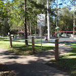

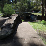

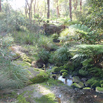
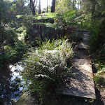
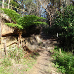
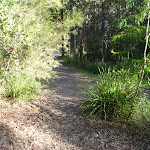

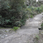
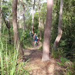
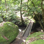
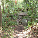
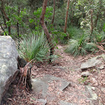
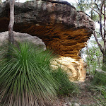


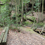
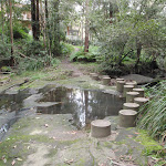
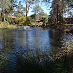
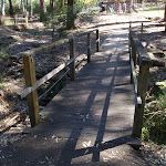
Cherrybrook Village shopping centre
The Cherrybrook Village shopping centre is located at 41/47 Shepherds Drive, Cherrybrook. There are a number of local cafes and eateries here, plus some franchises such as Subway and Gloria Jeans, making a great stop for walkers. There is also a Woolworths supermarket. The centre is open 9:00-5:30 Mon-Wed & Fri, 9:00-9:00 Thu, 9:00-5:00 Sat and 10:00-4:00 Sun. Some of the cafes and eateries open directly outside so they may be open longer hours. More info.
(0km) Top of The Lakes Of Cherrybrook park → Lakes trackhead
50 m
1 mins
0m
-4m
Very easy
From below 50 Shepherds Drive, opposite the shopping centre, the walk follows the concrete footpath into ‘The Lakes Of Cherrybrook’ park, keeping the playground to the right. The footpath comes to the signpost for ‘Callicoma Walk’ just before the unfenced lakes.
The Lakes Of Cherrybrook
The Lakes Of Cherrybrook is a park at the intersection of Shepherds Dr and Macquarie Dr, Cherrybrook. The lakes featured in the park were formed when the local creek was dammed for the benefit of farmers. The park has a free electric BBQ, sheltered picnic tables, taps and bubblers as well as a playground for the kids. There is a large shopping centre nearby. There are several signposted buswalks in the area, including the 5.1km ‘Callicoma Walk’ loop track.
(0.05km) Lakes trackhead → Int at stone wall
120 m
2 mins
1m
-4m
Very easy
Veer left: From the ‘Callicoma Walk’ signpost, the walk follows the ‘Sydney Cove’ arrow along the concrete footpath, keeping the lakes on the right. The walk passes a free BBQ and picnic shelters on the left, and a couple of viewing platforms on the right before coming to an intersection just before the road and beside a low handmade stone wall.
(0.17km) Int at stone wall → Int. of Blackwattle Trail and Callicoma Walk
180 m
3 mins
4m
-7m
Moderate track
Turn right: From behind the low stone wall, the track follows the concrete footpath down the hill through the graffiti-covered tunnel, emerging in a clearing behind the ‘Cherrybrook Girl Guides’ building.
Veer right: From the clearing, the walk follows the bush track, initially keeping the Girl Guides hall on the left. The track passes a shortcut track on the right before coming to a ‘T’ intersection with a management trail marked with track arrows.
Veer right: From the clearing, the walk follows the bush track, initially keeping the Girl Guides hall on the left. The track passes a shortcut track on the right before coming to a ‘T’ intersection with a management trail marked with track arrows.
(0.35km) Int. of Blackwattle Trail and Callicoma Walk → Top of the Disturbed Creek stairs
230 m
4 mins
0m
-7m
Moderate track
Veer right: From the intersection, the walk follows the management trail down the hill, keeping the houses to the left, arriving at the signposted intersection at the top of the stairs (with a track on the right).
(0.59km) Top of the Disturbed Creek stairs → Int of Callicoma Walk and McKinley trail
170 m
3 mins
0m
-8m
Moderate track
Veer right: From the intersection, the walk goes down the steps towards the creek. Immediately after crossing the creek, on concrete stepping stones, the walk bends to the left, following the ‘Callicoma Walk’ arrow. The walk soon crosses some old concrete slabs and then drops down some more steps. After following the creek, on the left, for a short distance the walk comes to an intersection (with a management trail coming down the hill on the right).
(0.76km) Int of Callicoma Walk and McKinley trail → Int of Callicoma Walk and Disturbed Creek trail
100 m
2 mins
5m
-3m
Moderate track
Veer left: From the intersection, the walk follows the management trail down the hill, keeping the creek on the left and soon arrives at a fork intersection.
(0.85km) Int of Callicoma Walk and Disturbed Creek trail → Int of Callicoma Walk and Pogson Dr management trail
180 m
4 mins
13m
-6m
Moderate track
Veer right: From the intersection, the walk follows the bush track, keeping the creek on the left and immediately passes a ‘Callicoma Walk’ signpost. The walk continues along the well formed bush track and climbs steeply to an intersection marked with a ‘Callicoma Walk’ and red GNW signpost.
(1.04km) Int of Callicoma Walk and Pogson Dr management trail → Jungo campsite
610 m
13 mins
8m
-38m
Moderate track
Turn left: From the intersection, the walk follows the asphalted management trail up, over the hill, keeping the houses up to the right and soon arrives at an intersection marked with a ‘Callicoma Walk’ and red GNW track marker.
Turn left: From the intersection, the walk follows the ‘Callicoma Walk’ arrow down the management trail (no asphalt), keeping the power lines to the left. The walk descends steeply for a while then flattens out and soon comes to an intersection with the Great North Walk.
Continue straight: From the intersection, this walk follows the ‘Great North Walk’ sign[1][2] along the wide trail as it bends left and leads downhill along the concrete section[3]. The trail leads down across a usually small creek[4], then heads up to the well-signposted intersection[5] beside the Jungo campsite[6][7], where a ‘Fishponds’ sign[8] points back down along the trail.
Turn left: From the intersection, the walk follows the ‘Callicoma Walk’ arrow down the management trail (no asphalt), keeping the power lines to the left. The walk descends steeply for a while then flattens out and soon comes to an intersection with the Great North Walk.
Continue straight: From the intersection, this walk follows the ‘Great North Walk’ sign[1][2] along the wide trail as it bends left and leads downhill along the concrete section[3]. The trail leads down across a usually small creek[4], then heads up to the well-signposted intersection[5] beside the Jungo campsite[6][7], where a ‘Fishponds’ sign[8] points back down along the trail.
The Jungo
The Jungo is a relatively small clearing and campsite near the junction of Berowra and ZigZag Creeks at a well signposted intersection[9]. There is often water in the creeks (treat well before drinking) but there are no facilities[10]. Speculation on the source of the name ‘Jungo’ includes the Aussie tendency to abbreviate words (‘Junction’ gets corrupted to ‘jung-o’ etc) as well as a possible derivation from one of a few similar sounding aboriginal words.
(1.65km) The Jungo → Int of Stringybark Ridge Management Trail and GNW
90 m
2 mins
3m
0m
Moderate track
Turn right: From ‘The Jungo’, the walk follows the ‘Callicoma Walk’ arrow along the management trail which climbs steeply and soon comes to the intersection (with the management trail going up the hill to the left and the red Great North Walk marker pointing straight ahead).
(1.74km) Int of Stringybark Ridge Management Trail and GNW → Callicoma Caves
880 m
18 mins
38m
-8m
Hard track
Continue straight: From the intersection, the walk follows the red Great North Walk marker along the bush track. The track undulates while following Berowra Creek (keeping the creek to the right) before crossing it on a metal foot bridge. The walk continues along the other side of the creek before crossing Nyrippin creek using concrete stepping stones. Immediately after the crossing, the walk arrives at the signposted intersection (with the ‘Callicoma Walk’ going to the right).
Turn right: From the intersection, the walk follows the ‘Callicoma Walk’ arrow along the bush track keeping (not crossing) Nyrippin creek to the right. The track soon swings up the hill to the left, away from the creek. The walk soon climbs some stone cut steps to the intersection at the top of a rocky outcrop.
Veer left: From the intersection, the walk follows the faint bush track, going steeply up the hill. The walk climbs up for a short distance, then arrives under a large overhang, marked with a number ‘6’ sign.
Callicoma caves
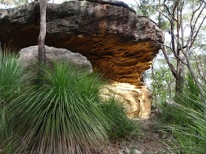
The Callicoma caves are a series of large sandstone overhangs on the Callicoma Walk near Cherrybrook. These beautiful sandstone overhangs are a highlight on the walks in the area. The sandstone has some beautiful texture and golden colouring.
(2.61km) Callicoma Caves → Nyrippin Creek four ways
210 m
5 mins
9m
-14m
Hard track
Veer right: From the number ‘6’ sign under the large overhang, the walk follows the bush track, around the rocks and base of the small cliffline (keeping them to the left). The walk passes under more large overhangs before dropping to an unmarked 4-way intersection.
(2.83km) Nyrippin Creek four ways → Int Callicoma Walk and power line access trail
300 m
6 mins
7m
-5m
Moderate track
Continue straight: From the intersection, the walk follows the bush track steeply down the steps towards the creek, where it bends to the left, onto an old management trail. The walk follows the management trail, keeping the creek on the right, before reaching a signposted intersection for the ‘Callicoma Walk’.
(3.13km) Int Callicoma Walk and power line access trail → Number 8 sign
30 m
0m
0m
Moderate track
Veer right: From the intersection, the walk follows the ‘Callicoma Walk’ arrow down the steps, towards the creek on the right. The track goes a short distance before reaching an intersection marked with an ‘8’ sign.
(3.16km) Number 8 sign → Coachwood grotto
20 m
1 mins
2m
0m
Moderate track
Turn right: From the intersection, the walk follows the steps steeply down the hill, soon coming to the viewing spot. At the end of this side trip, retrace your steps back to the main walk then Turn right.
Coachwood grotto
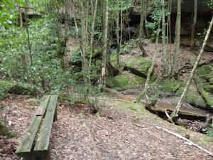
This beautiful, shady spot is beside Nyrippin creek, on the Callicoma Walk near Cherrybrook. The ‘grotto’ is an open area, shaded by Coachwood trees, with a curved section of low cliffs across the creek, giving an ‘amphitheatre’ feeling. This is a very atmospheric spot to sit and relax for a while.
(3.16km) Number 8 sign → Int of sewer management trail and Callicoma Walk
330 m
5 mins
4m
-2m
Moderate track
Continue straight: From the intersection, the walk follows the management trail, keeping the creek on the right, passing several sewer inspection points, before reaching an intersection marked with an arrow marker (with steps going steeply down to the right).
(3.49km) Int of sewer management trail and Callicoma Walk → Francis Greenway Dr trackhead
390 m
10 mins
38m
-7m
Moderate track
Turn right: From the intersection, the walk follows the steps steeply down the hill before meandering along the creek, on the right, then crossing the creek on concrete stepping stones. The walk follows the bush track up the hill a short distance before turning right at a ‘T’ intersection with an old management trail (just behind a house). Soon after this, the walk comes to an intersection marked with ‘Callicoma Walk’ arrows.
Turn left: From the intersection, the walk follows the ‘Callicoma Walk’ arrow steeply up the steps and soon arrives at Francis Greenway Drive.
Turn left: From the intersection, the walk follows the ‘Callicoma Walk’ arrow steeply up the steps and soon arrives at Francis Greenway Drive.
(3.87km) Francis Greenway Dr trackhead → Kenburn Ave entrance to lakes park
1.1 km
19 mins
17m
-35m
Moderate track
Continue straight: From the ‘Callicoma Walk’ signposted track head at the end of Macquarie Dr (intersection with Francis Greenway Dr, Cherrybrook), the walk follows Macquarie Dr up the hill. The walk soon turns left into Gumnut Rd (look for the Callicoma Walk track marker on the corner) and continues to the intersection with Holly Rd (another track marker here). From here, the walk goes a short distance along Holly Rd and crosses to the ‘Callicoma Walk Track marker near the small gate into ‘Gumnut Playground’.
Turn left: From the ‘Callicoma Walk’ track marker on Holly Rd, the walk goes through the gate and across ‘Gumnut Playground’ (there is a drinking bubbler near the fence). The walk goes out the gate on the opposite side and down a set of wooden steps to reach an arrow track marker beside Tallowwood Ave.
Turn right: From the arrow track marker beside Gumnut Playground, the walk follows Tallowwood Ave gently down the hill, passing Sheoak Cl, then turning left into Ivy Pl (track marker at this intersection). Just before the end of Ivy Pl, the walk turns right and follows a concrete path between the houses (between 12 & 14 Ivy Pl). From the end of this path, the walk crosses Rossian Pl and continues along Glentrees Pl, then turns left into Kenburn Ave (‘Callicoma Walk’ track marker at this intersection). A short distance along Kenburn Ave, the walk arrives at the entrance to ‘The Lakes Of Cherrybrook’.
(4.94km) Kenburn Ave entrance to lakes park → Top of The Lakes Of Cherrybrook park
210 m
4 mins
6m
-4m
Moderate track
Turn right: From ‘The Lakes of Cherrybook’ signpost on Tallowwood Ave, the walk follows the bush track into the park. The walk soon turns right at a junction with a ‘Callicoma Walk’ track marker, going down the steps and crossing a small bridge. The walk continues on the track as it skirts around the lake, to the left, dropping down a few steps and arriving at an intersection with an asphalted footpath and another bush track (There is a track marker just before the intersection).
Continue straight: From the intersection, the walk follows the asphalted footpath across the bridge, towards the playground. After crossing the bridge, the footpath becomes concrete and bends to the right and soon reaches the large walking track signpost with ‘Callicoma Walk’ at the top.
Turn left: From the ‘Callicoma Walk’ signpost intersection, the walk goes up the hill on the concrete footpath, keeping the playground on the left. At the top of the concrete footpath, the walk comes to Shepherds Drive, opposite the shopping centre and just below 50 Shepherds Drive.
Maps for the Callicoma Loop walk
You can download the PDF for this walk to print a map.
These maps below cover the walk and the wider area around the walk, they are worth carrying for safety reasons.
| Hornsby | 1:25 000 Map Series | 91304S HORNSBY | NSW-91304S |
| Sydney | 1:100 000 Map Series | 9130 SYDNEY | 9130 |
Cross sectional view of the Callicoma Loop bushwalking track

Analysis and summary of the altitude variation on the Callicoma Loop

Overview of this walks grade – based on the AS 2156.1 – 2001
Under this standard, a walk is graded based on the most difficult section of the walk.
| Length | 5.1 km | ||
| Time | 2 hrs | ||
| . | |||
| Grade 4/6 Hard track |
AS 2156.1 | Gradient | Short steep hills (3/6) |
| Quality of track | Rough track, where fallen trees and other obstacles are likely (4/6) | ||
| Signs | Directional signs along the way (3/6) | ||
| Experience Required | Some bushwalking experience recommended (3/6) | ||
| Weather | Storms may impact on navigation and safety (3/6) | ||
| Infrastructure | Limited facilities, not all cliffs are fenced (3/6) |
Some more details of this walks Grading
Here is a bit more details explaining grading looking at sections of the walk
Gradient
2.6km of this walk has gentle hills with occasional steps and another 2.3km has short steep hills. The remaining (260m) is flat with no steps.
Quality of track
2.7km of this walk follows a clear and well formed track or trail and another 1.8km follows a formed track, with some branches and other obstacles. Whilst another 320m follows a smooth and hardened path and the remaining 270m follows a rough track, where fallen trees and other obstacles are likely.
Signs
Around 4.8km of this walk has directional signs at most intersection, whilst the remaining 320m is clearly signposted.
Experience Required
Around 2.7km of this walk requires some bushwalking experience, whilst the remaining 2.4km requires no previous bushwalking experience.
weather
Around 3.9km of this walk is not usually affected by severe weather events (that would unexpectedly impact safety and navigation), whilst the remaining 1.3km is affected by storms that may impact your navigation and safety.
Infrastructure
Around 4.6km of this walk has limited facilities (such as not all cliffs fenced), whilst the remaining 560m is close to useful facilities (such as fenced cliffs and seats).
Similar walks
A list of walks that share part of the track with the Callicoma Loop walk.
439 m Circuit
15 mins
Moderate track
2.2 km One way
1 Hr
Moderate track
2.5 km Return
1 hr 30 mins
Hard track
4.1 km One way
1 hr 45 mins
Moderate track
4.2 km Circuit
1 hr 45 mins
Hard track
4.4 km One way
1 hr 45 mins
Moderate track
6.6 km Circuit
2 hrs 30 mins
Hard track
8.6 km One way
3 hrs 45 mins
Hard track
9 km One way
3 hrs 45 mins
Hard track
10.2 km One way
4 hrs
Hard track
15.5 km One way
6 hrs
Hard track
17.5 km One way
6 hrs 45 mins
Hard track
20.6 km One way
8 hrs
Hard track
25.8 km One way
2 Days
Hard track
28.1 km One way
2 Days
Hard track
35.9 km One way
2 Days
Hard track
44.4 km One way
3 Days
Hard track
Other Nearby walks
A list of walks that start near the Callicoma Loop walk.
515 m One way
15 mins
Moderate track
828 m Return
30 mins
Moderate track
619 m One way
30 mins
Moderate track
529 m One way
15 mins
Moderate track
1.4 km Return
30 mins
Moderate track
6.1 km One way
2 hrs 30 mins
Hard track
8.2 km Circuit
3 hrs
Hard track
717 m Circuit
20 mins
Very easy
14.7 km One way
5 hrs 30 mins
Hard track
4.2 km Circuit
2 hrs
Hard track
6.7 km Circuit
3 hrs
Hard track
16.1 km One way
6 hrs 45 mins
Hard track
Plan your trip to and from the walk here
The Callicoma Loop walk starts and ends at the Top of The Lakes Of Cherrybrook park (gps: -33.721735, 151.04418)
Your transport options to Top of The Lakes Of Cherrybrook park are by;
![]() Bus. (get details)
Bus. (get details)
![]() Car. There is free parking available.
Car. There is free parking available.
(get details)
Short URL = http://wild.tl/cl
Gallery images
There are other downloads I am still working on.
You will probably need to login to access these — still all free.
* KML (google earth file)
* GPX (GPS file)
Special Maps/ brochures
* A3 topo maps
* PDF with Lands Topo map base
* PDF with arial image (and map overlay)
I wanted to get the main site live first, this extra stuff will come in time.
Happy walking
Matt 🙂
Crosslands to Berowra Waters return
And Walk
Crosslands to Berowra Waters return

6 hrs
13.7 km Return
1005 m
Hard track
This return walk starts from the Crosslands Reserve and follows the Great North Walk along Berowra creek. The walk includes some boardwalks. After climbing up the side of the valley, the walk comes back down into Berowra Waters. Here you can enjoy lunch by Berowra Creek, at the Garden House restaurant, or catch the free car-ferry across the river to find the fish cafe.
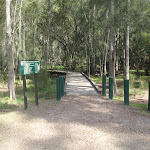

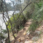
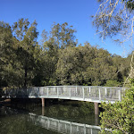
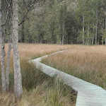


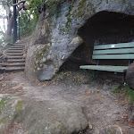


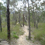

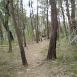
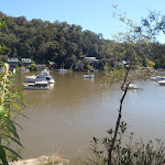
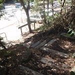
Crosslands
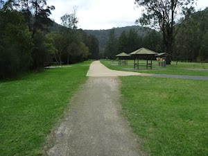
Crosslands Reserve is lovely and long mixed use picnic area, spanning along the edge of Berowra Creek. There are picnic tables[1], electric barbecues[2], toilets[3], car parking[4], a children’s playground[5], garbage bins[6], camping area, toilets

and town water[7]. The southern part of Crosslands is managed by Hornsby Council and the northern half by the NPWS within the Berowra Valley National Park.
The first inhabitants of this area were a subgroup of the Dharug people who enjoyed the sandstone caves, fish and abundant plant life in the area. It is now managed by Hornsby Shire Council, but in 1856 Matthew Charlton asked Burton Crossland to be caretaker on this area. Burton built a house and made a living by harvesting timber, growing fruit, fishing and boat-building.
(0km) Crosslands Carpark → Northern end of Crosslands carpark
250 m
4 mins
1m
0m
Very easy
From the car park, this walk follows the flat dirt path[11] between the road (on the right) and creek (on the left). The path leads through the casuarina trees for about 120m to pass the boat ramp[12]. After another 120m this walk comes to a locked gate[13] at the northern end of the car park[14]. There is also a wetland through the trees to the right worth noticing.
(0.25km) Northern end of Crosslands Carpark → Crosslands North
260 m
4 mins
1m
-2m
Very easy
Continue straight: From the northern end of Crosslands car park[15] (at the far northern end of Somerville Rd, Hornsby Heights), this walk follows the ‘Newcastle’ arrow[16] on the large ‘Great North Walk’ sign around the locked gate

and along the sealed old road[17]. The walk continues along the old road for just over 150m passing 4 picnic tables


to come to a y-intersection[18]. At the intersection this walk veers right, past the ‘Place of Winds’ sign[19] and wetland[20] (on your right). This walk continues along this old road for a little longer, coming to an intersection marked with a large ‘Crosslands’ information board[21] and ‘Great North walk’ sign[22]. This is just on the edge of the northern picnic area[23], not far from the toilet block[24]

.
Crosslands North Picnic area
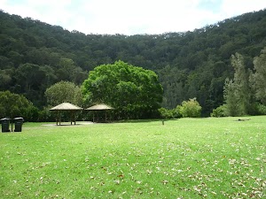
The northern section of Crosslands is in Berowra Valley NP and is a less formal picnic area compared with the southern area. There is a toilet block
[25][26] and a few sandy beaches with direct access to the water[27]. Here you will find a few picnic tables


and shelters


[28], as well as garbage bins[29]. The eastern side is home to a boardwalk exploring the estuarine wetland[30]. A pleasant area to rest and enjoy the water. Fires are only permitted in formally established fire places[31] .
(0.51km) Crosslands North → Estuaries viewing platform int.
220 m
4 mins
7m
-5m
Very easy
Turn right: From the intersection at the northern picnic area[32], this walk follows the ‘Great North Walk’ sign[33] along the timber boardwalk[34]

. The timber boardwalks winds through the mangroves for about 60m, coming to a firm dirt track[35] which leads for another 70m to a second timber boardwalk[36]. The second boardwalk leads for another 70m, past ‘Mangrove Food Cycle’ information signs[37] to come to an 3-way intersection[38] in the boardwalk with the estuaries viewing platform boardwalk[39] (on your left).
Berowra Creek (Estuarie) Lookout

The Estuarie lookout over Berowara Creek is found at the end of the wheelchair-accessible walk in Crosslands area. The timber lookout platform provides great views over Berowra Creek[40], the timber fence is 95cm high[41]. There are also information signs about the local flora and fauna[42] and the ‘Original Inhabitants’[43]. There are two timber bench seats

[44] encouraging you to take some time to soak up this view.
(0.73km) Estuaries viewing platform → Calna Creek Bridge intersection
780 m
20 mins
54m
-57m
Moderate track
Continue straight: From the intersection at the estuaries viewing platform, this walk follows the timber ramp down to the dirt track[45] and heads past the ‘..unsuitable for wheelchair access’ sign[46]. The track leads alongside the wide creek for about 200m to the ‘All creatures great and small’ information sign[47], then down a little way further to head along a short section of timber boardwalk[48].
About 100m further along the rocky track, this walk comes to a lookout and a ‘Catch the Threats’ information sign[49], where the track continues past the bench seat[50] and alongside the creek to the ‘The Rock Club’ information sign[51]. The track then leads among some grass tress[52] for just over 100m to the ‘Bush Supermarket’ information sign[53]. Just past this sign, the track begins to climb fairly steeply up the stone[54] and timber steps[55] to the ridge line, marked with a GNW arrow and a ‘Stop! Look! Listen! and Smell!’ information sign[56].
Continue straight: From the ridge line, this walk follows the GNW arrow east downhill, initially keeping the ‘Stop! Look! Listen! and Smell!’ information sign[57] on your right. The track bends left and follows the timber steps[58] as the track winds steeply down the side of the hill. Near the bottom of the hill, the track passes a ‘Rock n Roll’ information sign[59] then comes to a long, metal footbridge[60]. The walk crosses the bridge over Calna Creek and comes to a signposted intersection, with a ‘Fragile Marsh’ information sign[61]
(1.51km) Calna Creek Bridge intersection → Sams Creek Ridge Clearing
1.1 km
27 mins
67m
-58m
Moderate track
Veer left: From the intersection, this walk follows the ‘Berowra Waters’ sign[62] along the timber boardwalk[63]. The boardwalk leads for about 80m across the large open flat saltmarsh[64] into the casuarina forest[65] on the other side. Here the track bends left and leads along the side of the saltmarsh[66] for almost 200m, where the rocky track leads a little further before coming alongside Berowra Creek’s mangroves[67]. The track continues to gently undulate along the side of Berowra Creek for about 650m among the casuarinas[68] and grass tress[69], before heading up a fairly short, steep climb. At the top of this climb, the walk comes to a small, flat, pleasant clearing surrounded by large boulders[70].
(2.66km) Sams Creek ridge clearing → Sams Creek Crossing
500 m
11 mins
20m
-23m
Moderate track
Continue straight: From the clearing, this walk leads down the north eastern side of this ridge, keeping the main valley to your left. After about 100m this walk comes to another flat saltmarsh[71] , where the track bends right to soon come to a large flat clearing[72] beside Sams Creek[73] (subject to flooding).
The track then leads alongside Sams Creek (on your left) for about 350m when, just after climbing over a rock, the track comes to a ‘Crosslands’ sign[74] pointing back along the track, beside the creek.
The track then leads alongside Sams Creek (on your left) for about 350m when, just after climbing over a rock, the track comes to a ‘Crosslands’ sign[74] pointing back along the track, beside the creek.
(3.16km) Sams Creek Crossing → Int of Great North Walk and Berowra Link tracks
670 m
30 mins
181m
-44m
Hard track
Turn left: From the south side of the creek, this walk follows the ‘Berowra Waters’ sign[75] across the rocky Sams Creek. This creek may become impassable after heavy or prolonged rain. On the other side, the track veers left, crossing a rocky gully[76] and heads up the timber steps[77]. The track now starts to climb steeply, zigzagging up the timber steps [78] and a couple of staircases[79] for just over 300m to find a bench seat in a small sandstone cave[80]. After a rest, this walk continues up more steps (and staircases) for just over 150m, coming to a T-intersection with a wide service trail, where a ‘Crosslands’ sign[81] points back down the track.
(3.83km) Int of Great North Walk and Berowra Link tracks → Int of Naa Badu Lookout
260 m
7 mins
19m
-22m
Easy track
Turn left: From the intersection, this walk follows the ‘Berowra Waters’ sign[82] gently down along the management trail, keeping the valley to your left. The trail gently undulates along the side of the hill, enjoying some glimpses up to the cliff faces[83] (on the right). After about 180m, the trail crosses a concrete drain[84], then leads up the hill to find the signposted ‘Naa Badu’ lookout[85] and its great view[86].
Naa Badu Lookout
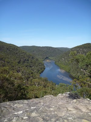
Naa Badu Lookout offers magnificent views south over Berowra Creek as well as over Sams and Calna Creeks. Naa Badu means ‘See water’[87] in the Aboriginal tribal language of the Dharug people. It is believed that Berowra Creek was the boundary between the Dharug and Guringai Aboriginal peoples. The lookout is fenced[88], has a bench seat[89], picnic table[90] and a fair amount of natural shade.
(4.09km) Int of Naa Badu Lookout → Int of Great North Walk and Banggarai Creek access track
320 m
7 mins
12m
-14m
Moderate track
Continue straight: From the ‘Naa Badu’ lookout[91], this walk follows the management trail over the small rise[92] and across the concrete ditch[93], keeping the valley to your left. The trail leads around the side of the hill for about 300m, gently undulating to come to an intersection with a narrow track and small clearing (on your left, as the trail bends right), just past the large scribbly gum. (This informal track leads down to an unfenced rock platform, with filtered views over Berowra Creek).
(4.41km) Int of Great North Walk and Banggarai Creek access track → Int of Great North Walk and Berkeley Close service trail
220 m
4 mins
4m
-12m
Moderate track
Continue straight: From the intersection, the walk follows the wide trail gently downhill as it bends right[94], keeping the valley to your left. After about 140m, the trail narrows a bit, leading down a few short but steeper sections[95] to an intersection (with some steps[96] on your left), where a ‘The Great North Walk’ sign[97] points back up along the trail.
(4.63km) Int of Great North Walk and Berkeley Close service trail → Int of Great North Walk and Currawong Road track
570 m
18 mins
78m
-31m
Hard track
Turn left: From the intersection, the walk follows the ‘Berowra Waters’ sign[98] down the timber steps. The walk then crosses Banggarai Creek using a timber bridge[99], and leads up some timber steps[100]. The rocky track then leads up some more timbers steps, between two rocks[101] then over a few rocks, where the track then flattens out. The now flat, sandy track[102] winds through the forest for about 150m and passes a timber seat[103], then leads down across a small gully[104] before the track begins to climb again. The track leads up some more timber steps[105], then the walk climbs two metal pegs[106] in the rock and continues to climb steeply up the rock and timber steps[107]. After 60m, the track[108] flattens out again, leading gently up through the scribbly gum[109] and angophora forest[110] for just over 100m to a three-way intersection marked with a couple of GNW arrow posts[111].
(5.2km) Int of Great North Walk and Currawong Road track → Washtub Gully Creek
1.3 km
33 mins
31m
-201m
Hard track
Turn left : From the intersection, this walk follows the GNW arrow post north-west down the sandy track[112], directly towards the valley. The track soon becomes rocky[113] and leads fairly steeply down the hill for about 150m before mostly flattening out and coming close to the top of an unfenced cliff with good views over Berowra Creek[114]. Here the rocky track continues more gently down along the top of the ridge[115] for about 200m and comes to a large rock platform[116]. This walk veers right to lead down the gap in the rock[117][118], climbing down some steel pegs[119] to where the track flattens out again[120]. The track leads across the saddle[121] for about 60m then veers left and follows along the base of a long rock wall[122] (on your right). Here the track leads down around the side of the ridge for just over 400m, passing some unfenced views for rock platforms[123][124][125] then down some sandstone steps[126] to find a tall sandstone overhang[127] with a timber seat[128]. From this cave, this walk continues along the base of the rock wall[129], and soon bends left and winds fairly steeply down a series of rock[130] and timber steps[131] to come to the edge of Berowra Creek (where there is a ‘no wash’ sign[132][133] facing the water from the rock platform). The track leads along the shore line for a short time to head onto the rock platform[134][135] in Washtub Gully.
(6.51km) Washtub Gully Creek → Berowra Waters trackhead
320 m
9 mins
31m
-30m
Moderate track
Continue straight: From Washtub Gully[136], this walk crosses the creek[137] and follows the track, keeping Berowra Creek not far to your left[138]. After about 50m, the track passes an old partially sunken boat[139], then about 100m further on, the track passes a view point that is an obviously popular (but not recommended) jumping spot[140]. The track then soon leads up some steps and over a rise[141] behind the ‘Berowra Waters Garden House’ restaurant[142], then heads down the steps[143] to come to the signposted ‘Berowra Waters Trackhead’[144][145] on ‘Berowra Waters Rd’[146].
Berowra Waters Garden House

#######CLOSED###### This picturesque little restaurant sits on the eastern side of Berowra Creek and is just a hop, skip and a jump from the ferry. With breakfast, lunch and dinner menus, the Garden House Restaurant is a great spot for those looking to tap into the Berowra Valley’s full potential. For information on bookings and opening hours phone (02)9456 2955.
The Fish Café
This seafood restaurant is located on the western side of the Berowra Waters Ferry, and offers casual dining with a great menu, overlooking the marina and river. The restaurant is open 7 days a week for breakfast and lunch, with dinner available on Friday through Sunday. The cafe is open 8:30 – 9pm Wed-Sun and closes at 3pm Mon & Tuesdays. Takeaway is also available, and the nearby reserve provides picnic tables, toilets, children’s playground and parking. Kayak hire is available from the marina building.
The Fish Café is located at 199 Bay Road, Berowra Waters, and the phone number is (02)9456 4665.
The Fish Café is located at 199 Bay Road, Berowra Waters, and the phone number is (02)9456 4665.
Waterview Restaurant
On the western side of Berowra Waters Ferry (free trip), just a short walk up the road, is the Waterview Restaurant, upstairs at the marina. The restaurant specialises in seafood, but also caters for other tastes in restaurant style dinning.
Some sittings offers A la Carte meals from $25, and other sittings offer a fresh and cooked seafood buffet. Please call ahead, as the restaurant is also a popular venue for weddings.
Open Friday-Sunday for lunch and dinner.
Phone (02) 9456 2633
199 Bay Rd Berowra Waters, NSW 2082
Some sittings offers A la Carte meals from $25, and other sittings offer a fresh and cooked seafood buffet. Please call ahead, as the restaurant is also a popular venue for weddings.
Open Friday-Sunday for lunch and dinner.
Phone (02) 9456 2633
199 Bay Rd Berowra Waters, NSW 2082
Maps for the Crosslands to Berowra Waters return walk
You can download the PDF for this walk to print a map.
These maps below cover the walk and the wider area around the walk, they are worth carrying for safety reasons.
| Hornsby | 1:25 000 Map Series | 91304S HORNSBY | NSW-91304S |
| Cowan | 1:25 000 Map Series | 91304N COWAN | NSW-91304N |
| Ku-ring-gai Chase National Park Tourist Map | 1:40 000 Map Series | CMA Ku-ring-gai Chase National Park Tourist Map | CMA Ku-ring-gai Chase National Park Tourist Map |
| Sydney | 1:100 000 Map Series | 9130 SYDNEY | 9130 |
Cross sectional view of the Crosslands to Berowra Waters return bushwalking track

Analysis and summary of the altitude variation on the Crosslands to Berowra Waters return

Overview of this walks grade – based on the AS 2156.1 – 2001
Under this standard, a walk is graded based on the most difficult section of the walk.
| Length | 13.7 km | ||
| Time | 6 hrs | ||
| . | |||
| Grade 4/6 Hard track |
AS 2156.1 | Gradient | Very steep (4/6) |
| Quality of track | Rough track, where fallen trees and other obstacles are likely (4/6) | ||
| Signs | Directional signs along the way (3/6) | ||
| Experience Required | Moderate level of bushwalking experience recommended (4/6) | ||
| Weather | Weather generally has little impact on safety (1/6) | ||
| Infrastructure | Limited facilities, not all cliffs are fenced (3/6) |
Some more details of this walks Grading
Here is a bit more details explaining grading looking at sections of the walk
Gradient
2.6km of this walk is very steep and another 2.4km has short steep hills. Whilst another 1.1km has gentle hills with occasional steps and the remaining 730m is flat with no steps.
Quality of track
3.4km of this walk follows a formed track, with some branches and other obstacles and another 1.9km follows a rough track, where fallen trees and other obstacles are likely. Whilst another 810m follows a clear and well formed track or trail and the remaining 730m follows a smooth and hardened path.
Signs
Around 6km of this walk has directional signs at most intersection, whilst the remaining 990m is clearly signposted.
Experience Required
4.6km of this walk requires some bushwalking experience and another 1.5km requires no previous bushwalking experience. The remaining (670m) requires a leader a with moderate level of bushwalking experience.
weather
This whole walk, 7km is not usually affected by severe weather events (that would unexpectedly impact safety and navigation).
Infrastructure
Around 4.1km of this walk is close to useful facilities (such as fenced cliffs and seats), whilst the remaining 2.8km has limited facilities (such as not all cliffs fenced).
Similar walks
A list of walks that share part of the track with the Crosslands to Berowra Waters return walk.
980 m Return
30 mins
Very easy
5.7 km One way
2 hrs 45 mins
Hard track
8.2 km Return
3 hrs 30 mins
Hard track
9.7 km One way
4 hrs 15 mins
Hard track
12.6 km One way
5 hrs 30 mins
Hard track
12.9 km One way
6 hrs
Hard track
12.9 km One way
5 hrs 30 mins
Hard track
14 km One way
7 hrs 30 mins
Hard track
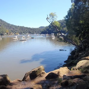
17.2 km One way
8 hrs
Hard track
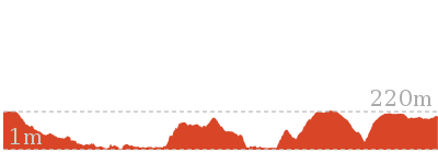
22.3 km One way
9 hrs
Hard track
22.6 km One way
9 hrs 18 mins
Hard track
27.4 km One way
2 Days
Hard track
28.1 km One way
2 Days
Hard track
35.9 km One way
2 Days
Hard track
43.1 km One way
3 Days
Hard track
Other Nearby walks
A list of walks that start near the Crosslands to Berowra Waters return walk.
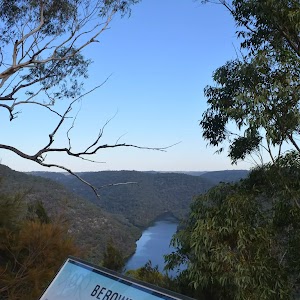
420 m Return
15 mins
Very easy
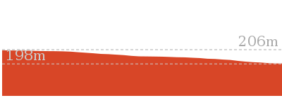
9.4 km One way
4 hrs 30 mins
Hard track
8.7 km One way
4 hrs
Hard track
7.2 km One way
3 hrs 30 mins
Hard track
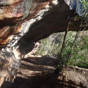
9.4 km Return
4 hrs
Hard track
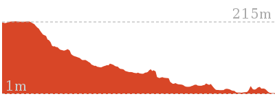
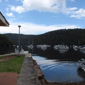
3.9 km Circuit
2 hrs
Hard track
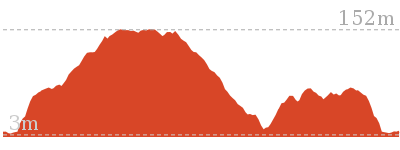
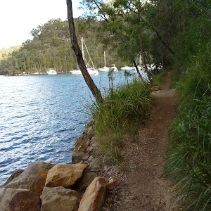
5.3 km One way
2 hrs 30 mins
Hard track
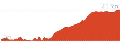

1.1 km Return
1 Hr
Hard track
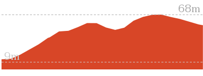
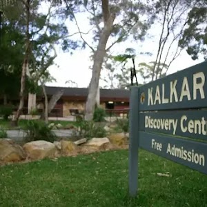
4.4 km Return
2 hrs
Moderate track
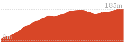
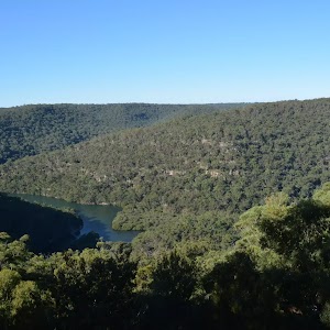
798 m Circuit
30 mins
Very easy
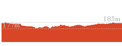

5.2 km Circuit
2 hrs 15 mins
Hard track
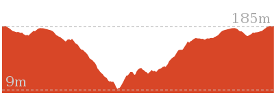
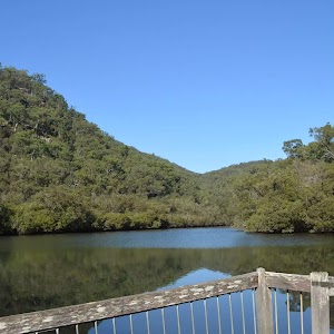
552 m Return
15 mins
Very easy
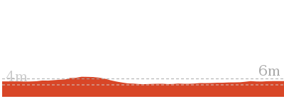
Plan your trip to and from the walk here
The Crosslands to Berowra Waters return walk starts and ends at the Crosslands Carpark (gps: -33.628707, 151.10905)
Your main transport option to Crosslands Carpark is by;
![]() Car. There is free parking available.
Car. There is free parking available.
(get details)
Short URL = http://wild.tl/ctbwr
Gallery images
There are other downloads I am still working on.
You will probably need to login to access these — still all free.
* KML (google earth file)
* GPX (GPS file)
Special Maps/ brochures
* A3 topo maps
* PDF with Lands Topo map base
* PDF with arial image (and map overlay)
I wanted to get the main site live first, this extra stuff will come in time.
Happy walking
Matt 🙂
Hornsby to Fishponds
And Walk
Hornsby to Fishponds
2 hrs 30 mins
5.6 km Return
296 m
Hard track
A short walk from Hornsby to reach a great spot for admiring Berowra Creek. This walk explores several different environments in the Regional Park along the way. Allow some time to sit and enjoy the view at Fishponds. Expect to see other people along the track as this is one of the most popular walks in the area.
(0km) Hornsby Train Station → Int of Quarry Road and Great North Walk
720 m
14 mins
8m
-34m
Easy track
From the western side of Hornsby Railway Station[1], this walk first crosses the bus lane, then follows the large ‘To the Great North Walk’ sign[2] across the Station St pedestrian crossing[3], and then across the Pacific Highway at the traffic lights[4]. Here the walk turns right and follows the footpath (across ‘Dural Lane’[5]) past some shops to cross ‘Dural St’[6]. The walk then turns left and follows the footpath down along ‘Dural St’[7], past a few more shops. Continuing past the units, this walk then turns right onto ‘Quarry Rd’[8][9] and follows the road down the gently hill for about 180m to an intersection with ‘Old Mans Valley’ management trail[10] and locked gate (on your right).
Continue straight: From the intersection, this walk follows Quarry Road down the gentle hill, leaving the houses[11][12] behind to come to an intersection with a track, signposted with a ‘Great North Walk’ sign[13] (on your left).
Continue straight: From the intersection, this walk follows Quarry Road down the gentle hill, leaving the houses[11][12] behind to come to an intersection with a track, signposted with a ‘Great North Walk’ sign[13] (on your left).
(0.72km) Int of Quarry Road and Great North Walk → Berowra Valley Bushland Park
540 m
14 mins
12m
-89m
Hard track
Turn left: From the intersection, this walk follows the ‘Great North Walk’ sign[14] up the hill. The track leads up over the rise, then continues down to the intersection with the Quarry Rd Management trail[15].
Continue straight: From the intersection, this walk follows the ‘Great North Walk’ sign[16] down the steep rock steps[17]. The walk winds steeply down a number of sets of stone steps, passing some large rock walls for a bit over 100m, to find a welcome flat section of track[18] midway the hill. As the track leads past some houses (through the trees on your left), this walk heads down more steps[19] before coming to the open area of ‘Berowra Valley Bushland Park’[20][21], at the end of Rosemead Road[22].
Continue straight: From the intersection, this walk follows the ‘Great North Walk’ sign[16] down the steep rock steps[17]. The walk winds steeply down a number of sets of stone steps, passing some large rock walls for a bit over 100m, to find a welcome flat section of track[18] midway the hill. As the track leads past some houses (through the trees on your left), this walk heads down more steps[19] before coming to the open area of ‘Berowra Valley Bushland Park’[20][21], at the end of Rosemead Road[22].
Berowra Valley Bushland Park
‘Berowra Valley Bushland Park’[23] is also known as Rosemead Rd Park and is found at the bottom end of Rosemead Rd[24], Hornsby. This is an open area park surrounded by shady eucalyptus trees[25], making a pleasant spot to rest on a walk. It has a picnic table with bench seats[26], and a sheltered free electric BBQ[27]. There is a water tap[28] in the park, near the road. There is also a ‘Welcome to Old Mans Valley’ information sign with information about the traditional country of the Darug and Guringai peoples[29].
(1.26km) Berowra Valley Bushland Park → Int of Blue Gum Walk and Joes Mountain Service Trail
890 m
20 mins
45m
-39m
Moderate track
Veer right: From the lower side of Berowra Valley Bushland Park[30] (at the end of Rosemead Rd, Hornsby[31]), this walk follows the ‘Fishponds 1.2km’ arrow on the large sign[32], down the track[33] for approximately 30m, to the intersection with the Rosemead management trail[34], marked with a Great North Walk arrow.
Veer right: From the intersection, this walk heads downhill along the wide rocky management trail[35] as it bends left (and passing some houses off to the left). The trail then bends right[36] and leads across Old Mans Creek using some concrete stepping stones[37]. The walk then continues by heading up the moderately steep hill and then through a thick blue gum and bracken fern forest[38]. The wide trail leads to the top of the hill then bends left, (ignoring the track on the right[39]) to pass over a saddle[40]. Here the trail leads down the gentle hill[41], through the turpentine forest for just over 300m to find an intersection with narrower track on the right, marked with arrow posts[42].
Veer right: From the intersection, this walk heads downhill along the wide rocky management trail[35] as it bends left (and passing some houses off to the left). The trail then bends right[36] and leads across Old Mans Creek using some concrete stepping stones[37]. The walk then continues by heading up the moderately steep hill and then through a thick blue gum and bracken fern forest[38]. The wide trail leads to the top of the hill then bends left, (ignoring the track on the right[39]) to pass over a saddle[40]. Here the trail leads down the gentle hill[41], through the turpentine forest for just over 300m to find an intersection with narrower track on the right, marked with arrow posts[42].
(2.15km) Int of Blue Gum Walk and Joes Mountain Service Trail → Fishponds Lookout
300 m
7 mins
0m
-39m
Moderate track
Veer right: From the intersection, the walk follows the ‘Great North Walk’ arrow[43] down the narrower track a short distance to find a three-way intersection marked with a large ‘Great North walk’ signpost[44].
Continue straight: From the intersection, this walk follows the ‘Fishponds’ sign[45] along the flat narrow track past the ‘Berowra Valley Regional Park’ sign[46]. The track soon bends left (passing along the top of an unfenced cliff) then winds down some steep carved rock steps (with a hand rail)[47]. The rocky track then leads down along the side of the valley for just over 100m to cross a timber foot bridge[48]. The track then continues for another 70m to find a fenced rock platform[49] and signposted intersection[50].
Continue straight: From the intersection, this walk follows the ‘Fishponds’ sign[45] along the flat narrow track past the ‘Berowra Valley Regional Park’ sign[46]. The track soon bends left (passing along the top of an unfenced cliff) then winds down some steep carved rock steps (with a hand rail)[47]. The rocky track then leads down along the side of the valley for just over 100m to cross a timber foot bridge[48]. The track then continues for another 70m to find a fenced rock platform[49] and signposted intersection[50].
Fishponds Lookout
Fishponds Lookout is a fenced rock platform at the intersection of the Benowie walking track and the Rosemead trackhead. It is marked with a number of Great North Walk signs. This informally named lookout has good views down over Fishponds, a large waterhole on Berowra Creek. Looking north across the creek, there are views to the upper waterhole and the cliffs on the other side.
(2.45km) Fishponds Lookout → Fishponds Bridge
350 m
8 mins
16m
-14m
Moderate track
Turn right: From the lookout[51], this walk follows the ‘Galston Gorge’ sign[52] along the fenced rock shelf (keeping the fence to your left). The track leads down the rocky steps to the edge of Berowra Creek[53]. The walk crosses the creek using the stepping stones, and comes to a small cave[54] on the other side. This creek may be impassable after rain[55].
Veer right: From the cave, this walk follows the ‘Galston Gorge’ sign[56] up the track and timbers steps. Soon the track turns left and follows a Great North Walk arrow up the hill[57], at the red and white ‘Danger’ sign[58](ignoring the other track). The track climbs up the carved steps[59] onto the rock platform and continues up the rocky track until just after passing through a narrow gap between two rocks[60], where this walk comes to the un-signposted (and faint) intersection with the Pogson’s Trig track (on the left).
Continue straight: From the intersection, this walk heads down along the side of the hill[61], whilst keeping the main valley to your right. The track leads down some rocky steps, passing just above a rock platform (a short distance down on your right, with a plaque dedicated to ‘Cora’[62]). The track then leads down along the base of a cliff, passing under a rock overhang[63]. The track continues along the base of the cliff for another 50m then starts to wind downhill (with some handrails[64]) to come to a rock platform beside the creek[65]. This walk then crosses Berowra Creek on the flat timber bridge[66].
Fishponds
Fishponds is a long waterhole[67] on Berowra Creek in Berowra Valley Regional Park. The waterhole is lined with tall cliffs[68] and a few sandstone caves. At the southern end, there are stepping stones to help cross the creek[69], and a small timber bridge[70] at the northern end. This is a beautiful spot and a worthy place to rest and enjoy the water passing by[71]. The waterhole is fairly popular with local teens in summer, cooling off. Swimming and jumping at the Fishponds waterhole has resulted in fatalities – please heed the signs and Cora’s parents’ plea and enjoy the water from the edge.
Maps for the Hornsby to Fishponds walk
You can download the PDF for this walk to print a map.
These maps below cover the walk and the wider area around the walk, they are worth carrying for safety reasons.
| Hornsby | 1:25 000 Map Series | 91304S HORNSBY | NSW-91304S |
| Sydney | 1:100 000 Map Series | 9130 SYDNEY | 9130 |
Cross sectional view of the Hornsby to Fishponds bushwalking track
Analysis and summary of the altitude variation on the Hornsby to Fishponds
Overview of this walks grade – based on the AS 2156.1 – 2001
Under this standard, a walk is graded based on the most difficult section of the walk.
| Length | 5.6 km | ||
| Time | 2 hrs 30 mins | ||
| . | |||
| Grade 4/6 Hard track |
AS 2156.1 | Gradient | Very steep (4/6) |
| Quality of track | Formed track, with some branches and other obstacles (3/6) | ||
| Signs | Directional signs along the way (3/6) | ||
| Experience Required | Some bushwalking experience recommended (3/6) | ||
| Weather | Storms may impact on navigation and safety (3/6) | ||
| Infrastructure | Limited facilities, not all cliffs are fenced (3/6) |
Some more details of this walks Grading
Here is a bit more details explaining grading looking at sections of the walk
Gradient
1.2km of this walk has short steep hills and another 1km has gentle hills with occasional steps. Whilst another 350m is very steep and the remaining 180m is flat with no steps.
Quality of track
1.7km of this walk follows a clear and well formed track or trail and another 890m follows a formed track, with some branches and other obstacles. The remaining (180m) follows a smooth and hardened path.
Signs
Around 1.7km of this walk has directional signs at most intersection, whilst the remaining 1km is clearly signposted.
Experience Required
Around 2.1km of this walk requires no previous bushwalking experience, whilst the remaining 690m requires some bushwalking experience.
weather
Around 2.7km of this walk is not usually affected by severe weather events (that would unexpectedly impact safety and navigation), whilst the remaining 70m is affected by storms that may impact your navigation and safety.
Infrastructure
Around 1.9km of this walk is close to useful facilities (such as fenced cliffs and seats), whilst the remaining 890m has limited facilities (such as not all cliffs fenced).
Similar walks
A list of walks that share part of the track with the Hornsby to Fishponds walk.
4.2 km Circuit
2 hrs
Hard track
6.7 km Circuit
3 hrs
Hard track
9 km One way
3 hrs 45 mins
Hard track
9.7 km One way
4 hrs
Hard track
10.2 km One way
4 hrs
Hard track
15.5 km One way
6 hrs
Hard track
16.1 km One way
6 hrs 45 mins
Hard track
17.5 km One way
6 hrs 45 mins
Hard track
20.6 km One way
8 hrs
Hard track
22.3 km One way
9 hrs
Hard track
22.6 km One way
9 hrs 18 mins
Hard track
25.8 km One way
2 Days
Hard track
28.1 km One way
2 Days
Hard track
35.9 km One way
2 Days
Hard track
43.1 km One way
3 Days
Hard track
44.4 km One way
3 Days
Hard track
Other Nearby walks
A list of walks that start near the Hornsby to Fishponds walk.
8.6 km One way
3 hrs 45 mins
Hard track
499 m One way
15 mins
Easy track
6.5 km One way
2 hrs 30 mins
Hard track
14.7 km One way
5 hrs 30 mins
Hard track
1.4 km Return
30 mins
Moderate track
828 m Return
30 mins
Moderate track
515 m One way
15 mins
Moderate track
6.2 km One way
2 hrs 45 mins
Moderate track
3.4 km One way
1 hr 30 mins
Moderate track
6.1 km One way
2 hrs 30 mins
Hard track
6.6 km Circuit
2 hrs 30 mins
Hard track
619 m One way
30 mins
Moderate track
Plan your trip to and from the walk here
The Hornsby to Fishponds walk starts and ends at the Hornsby Train Station (gps: -33.703509, 151.09801)
Your transport options to Hornsby Train Station are by;
![]() Train. (get details)
Train. (get details)
![]() Bus. (get details)
Bus. (get details)
![]() Car. There is free parking available.
Car. There is free parking available.
(get details)
Short URL = http://wild.tl/htf
Gallery images
There are other downloads I am still working on.
You will probably need to login to access these — still all free.
* KML (google earth file)
* GPX (GPS file)
Special Maps/ brochures
* A3 topo maps
* PDF with Lands Topo map base
* PDF with arial image (and map overlay)
I wanted to get the main site live first, this extra stuff will come in time.
Happy walking
Matt 🙂
Comments