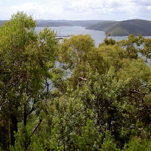
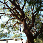
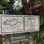
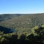
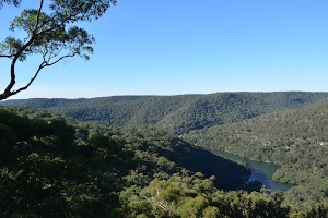
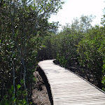
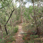
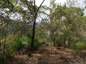
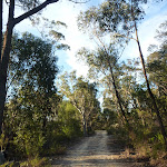
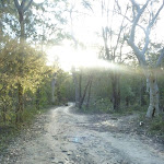
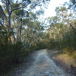
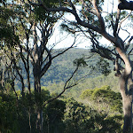
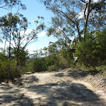
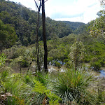
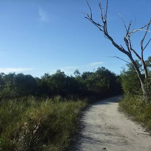
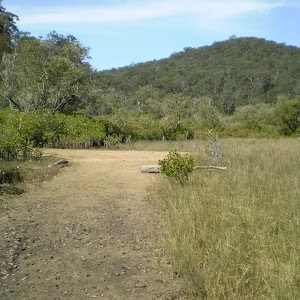
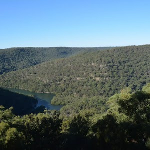
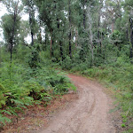
This is a short walk down to Red Hands Cave from the Resolute Picnic Area. The walk loops from the picnic area through the heath and down to the overhang of the cave. The Aboriginal rock art is quite faded but is estimated to be over 2000 years old. This makes for an interesting historic walk, great as an appetiser before a picnic lunch at Resolute Picnic Area.
Red Hands Cave
And Walk
Red Hands Cave


30 mins
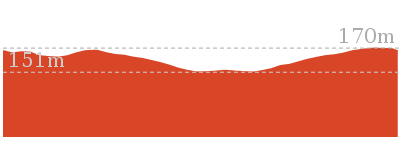
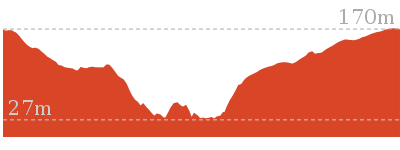
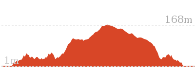
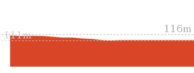
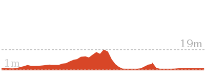
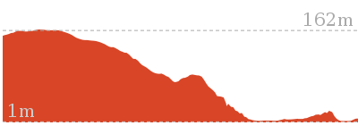
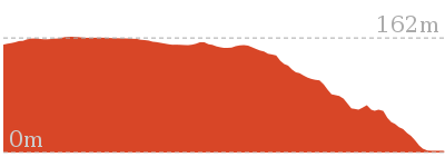
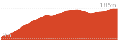
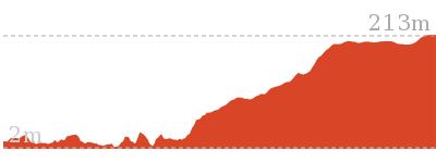
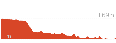
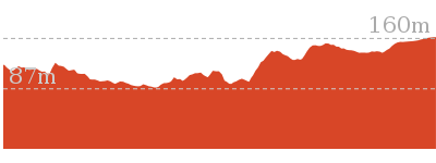
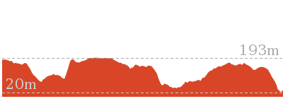
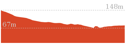
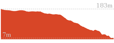
403 m Circuit

9 m
Moderate track


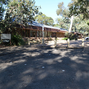
Resolute Picnic Area
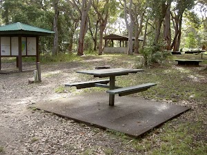
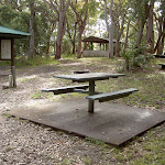
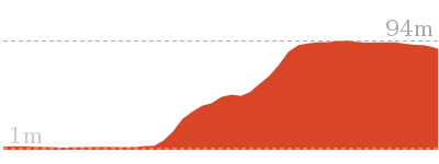
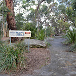
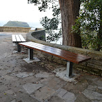
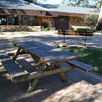
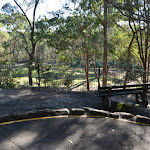
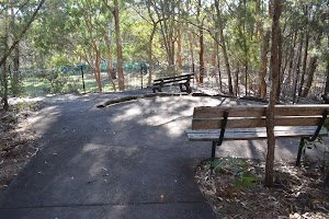
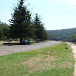
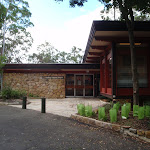
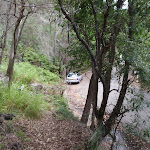
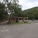
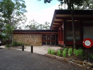
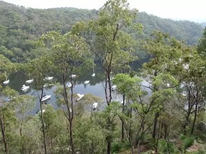
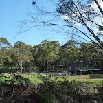
Resolute picnic area, Ku-ring-gai Chase National Park, is a large grassed area with benches, shelter, interpretive signs, electric BBQ’s and an environmentally-friendly toilet block. The picnic area does not have drinking water, but does have a pay phone and wheelchair-accessible bathroom with baby-changing area. Resolute picnic area is a great place for lunch, with Red Hands Cave, West Head and Resolute Beach and West Head Lookout tracks starting from the picnic area. The picnic area has adequate parking and a bus turn-around area.
(0km) Resolute Picnic Area → Red Hands Cave

250 m
4 mins
2m
-8m
Moderate track
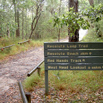
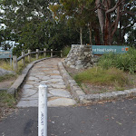
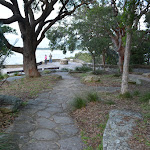
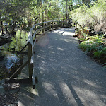
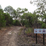
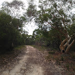
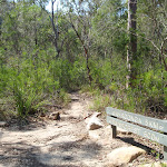
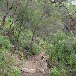
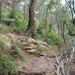
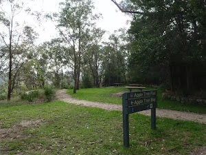
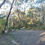
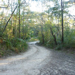
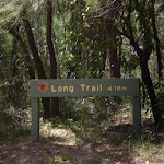
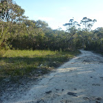
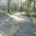
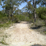
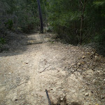
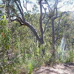
From Resolute Picnic Area, this walk follow the signs for ‘Red Hands Cave’ away from the picnic area. The track heads down the sandy service trail for approximately 100m to the intersection marked by the sign on the left.
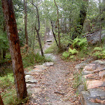
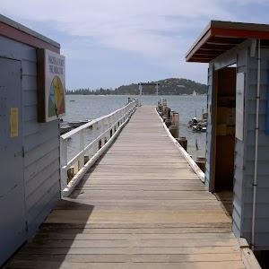
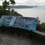
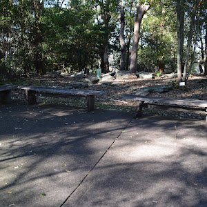
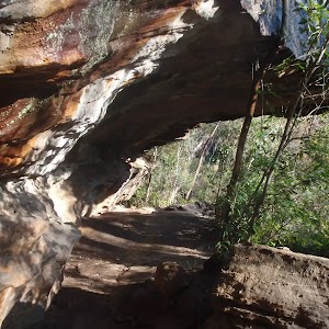
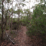
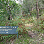
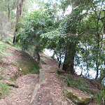
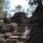
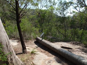
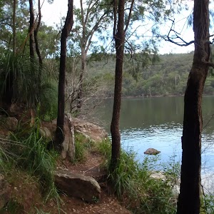
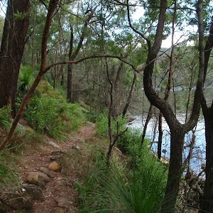
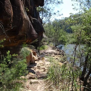
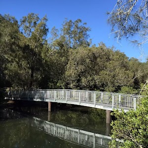
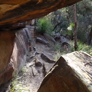
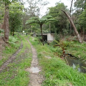
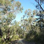
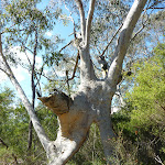
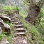
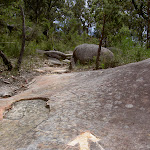
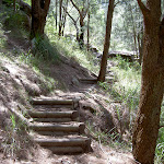
Turn left: From the intersection, this walk follows the sign to ‘Red Hands Cave 0.85km’ away from the service trail. The track heads slightly downhill before turning right. The track then drops down some stairs, passing around and down a rock shelf to continue to an overhanging rock – Red Hands Cave. The cave is fenced off and marked with informative signs.
Turn left: From the intersection, this walk follows the sign to ‘Red Hands Cave 0.85km’ away from the service trail. The track heads slightly downhill before turning right. The track then drops down some stairs, passing around and down a rock shelf to continue to an overhanging rock – Red Hands Cave. The cave is fenced off and marked with informative signs.
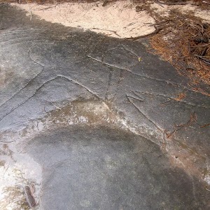
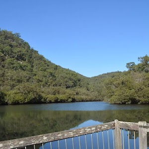
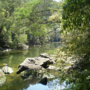
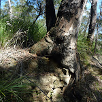
Red Hands Cave
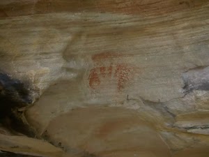
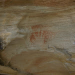
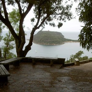
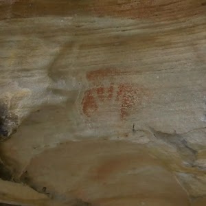
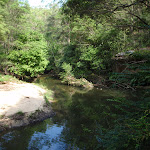
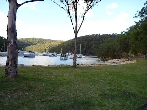
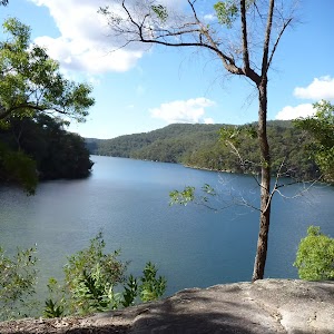
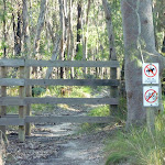
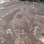
Red Hands Cave, Ku-ring-gai Chase National Park, is a small rock overhang just near Resolute Picnic Area. The red hands are made by ochre, clay, being blown over an outspread hand. This Aboriginal rock art has been given an estimation of approximately 2000 years in age.
(0.25km) Red Hands Cave → Resolute Picnic Area
150 m
3 mins
7m
-1m
Moderate track
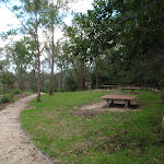
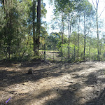
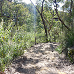
Continue straight: From Red Hands Cave, the walk heads up the slight hill keeping the rocky outcrop to the left of the track. The walk leads approximately 30m to a signposted intersection.
Continue straight: From the intersection, the walk heads along the rocky outcrop keeping it on the left as it heads up the stairs for approximately 30m into Resolute Picnic Area.
Continue straight: From the intersection, the walk heads along the rocky outcrop keeping it on the left as it heads up the stairs for approximately 30m into Resolute Picnic Area.
Maps for the Red Hands Cave walk
You can download the PDF for this walk to print a map.
These maps below cover the walk and the wider area around the walk, they are worth carrying for safety reasons.
| Broken Bay | 1:25 000 Map Series | 91301N BROKEN BAY | NSW-91301N |
| Ku-ring-gai Chase National Park Tourist Map | 1:40 000 Map Series | CMA Ku-ring-gai Chase National Park Tourist Map | CMA Ku-ring-gai Chase National Park Tourist Map |
| Sydney | 1:100 000 Map Series | 9130 SYDNEY | 9130 |
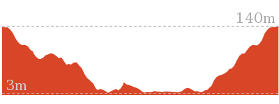
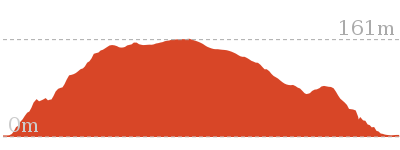
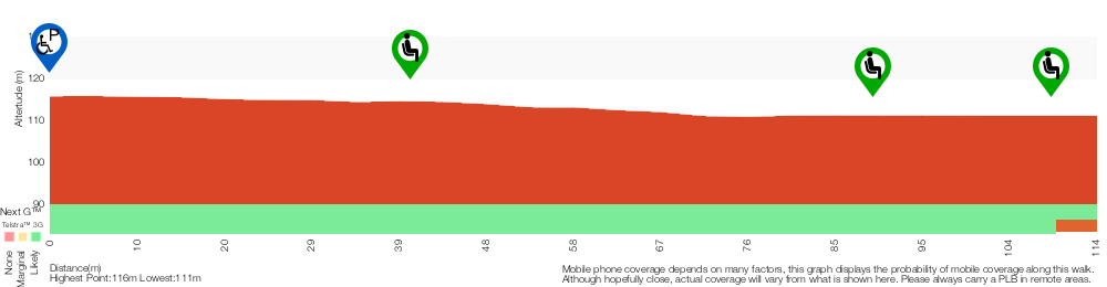
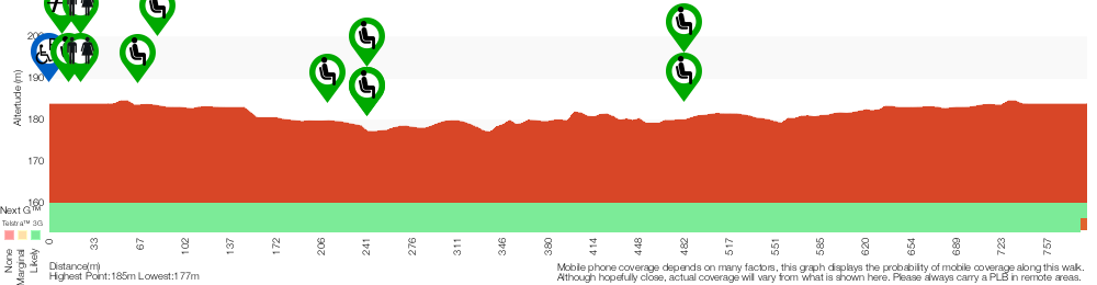
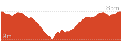
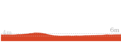
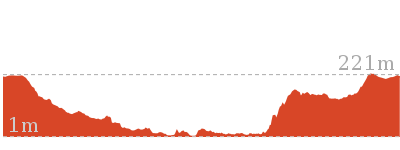
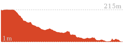
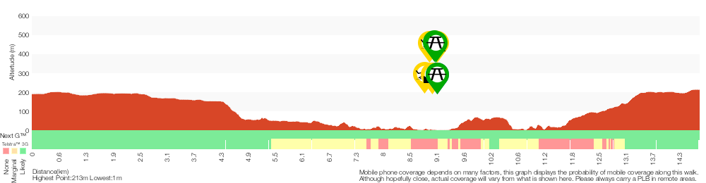
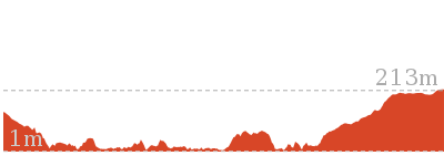
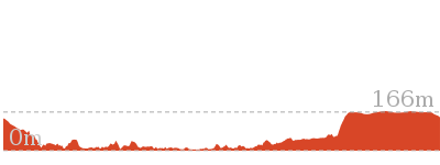
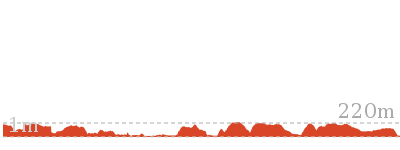
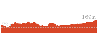
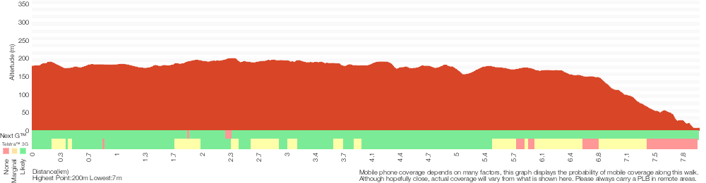
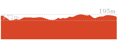
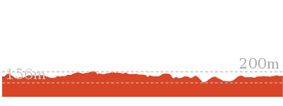
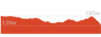
Cross sectional view of the Red Hands Cave bushwalking track
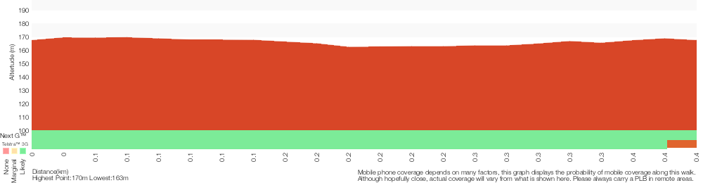
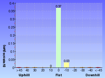
Analysis and summary of the altitude variation on the Red Hands Cave
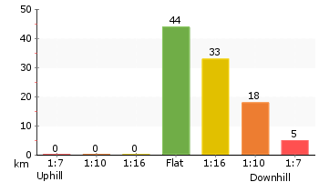
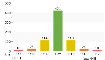
Overview of this walks grade – based on the AS 2156.1 – 2001
Under this standard, a walk is graded based on the most difficult section of the walk.
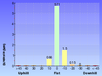
| Length | 403 m | ||
| Time | 30 mins | ||
| . | |||
| Grade 3/6 Moderate track |
AS 2156.1 | Gradient | Short steep hills (3/6) |
| Quality of track | Formed track, with some branches and other obstacles (3/6) | ||
| Signs | Clearly signposted (1/6) | ||
| Experience Required | No experience required (1/6) | ||
| Weather | Weather generally has little impact on safety (1/6) | ||
| Infrastructure | Limited facilities, not all cliffs are fenced (3/6) |
Some more details of this walks Grading
Here is a bit more details explaining grading looking at sections of the walk
Gradient
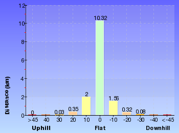
Around 270m of this walk has gentle hills with occasional steps, whilst the remaining 130m has short steep hills.
Quality of track
This whole walk, 400m follows a formed track, with some branches and other obstacles.
Signs
This whole walk, 400m is clearly signposted.
Experience Required
This whole walk, 400m requires no previous bushwalking experience.
weather
This whole walk, 400m is not usually affected by severe weather events (that would unexpectedly impact safety and navigation).
Infrastructure
Around 290m of this walk is close to useful facilities (such as fenced cliffs and seats), whilst the remaining 120m has limited facilities (such as not all cliffs fenced).
Similar walks
A list of walks that share part of the track with the Red Hands Cave walk.
1.1 km Circuit
45 mins
Moderate track
1.9 km Return
1 Hr
Moderate track
3.5 km Circuit
1 hr 45 mins
Hard track
3.7 km Return
1 hr 30 mins
Hard track
5.4 km Circuit
3 hrs
Hard track
8.6 km Circuit
5 hrs
Hard track

Other Nearby walks
A list of walks that start near the Red Hands Cave walk.
810 m Circuit
30 mins
Moderate track

238 m Return
10 mins
Easy track

2.8 km Circuit
1 hr 30 mins
Very experienced only

2.1 km Return
1 Hr
Moderate track

1.9 km Return
1 Hr
Hard track
1.4 km Circuit
45 mins
Moderate track

2.3 km Return
1 hr 30 mins
Hard track
8.2 km Return
3 hrs
Hard track
5.9 km Circuit
3 hrs
Hard track
5.6 km Return
2 hrs 30 mins
Moderate track
3 km Return
1 hr 15 mins
Moderate track
4.5 km One way
1 hr 45 mins
Hard track
Plan your trip to and from the walk here
The Red Hands Cave walk starts and ends at the Resolute Picnic Area (gps: -33.577895, 151.30009)
Your main transport option to Resolute Picnic Area is by;
![]() Car. A park entry fee is required for driving into the park.
Car. A park entry fee is required for driving into the park.
(get details)


Short URL = http://wild.tl/r
Gallery images
There are other downloads I am still working on.
You will probably need to login to access these — still all free.
* KML (google earth file)
* GPX (GPS file)
Special Maps/ brochures
* A3 topo maps
* PDF with Lands Topo map base
* PDF with arial image (and map overlay)
I wanted to get the main site live first, this extra stuff will come in time.
Happy walking
Matt 🙂
West Head Lookout
And Walk
West Head Lookout

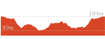
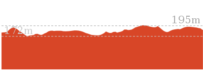
10 mins
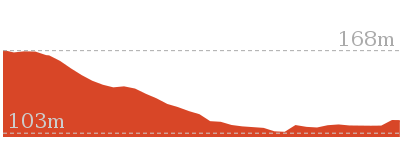
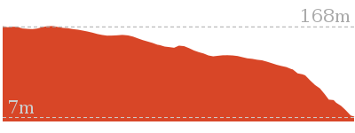
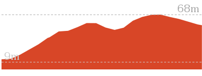
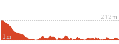
238 m Return
18 m
Easy track
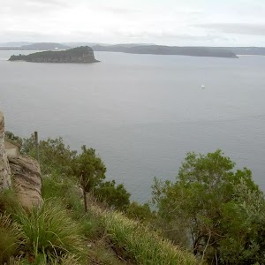
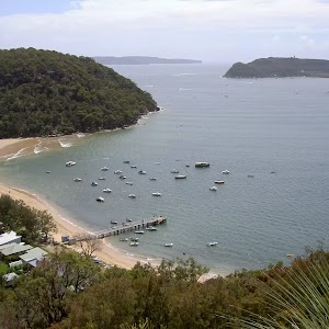
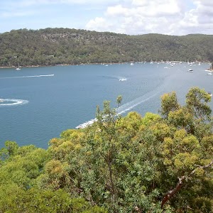
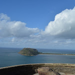
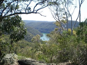
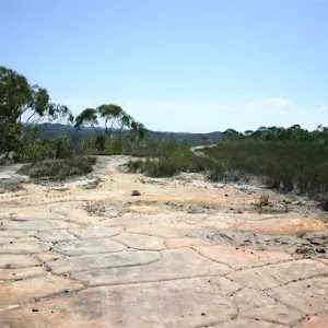
This walk is all about the stunning views from the edge of West Head. After the lovely drive through the bushland along the West Head Rd you will love this gentle stroll down to what feels like the edge of the earth. There are great views across the Pittwater to Barenjoey Head as well as across the mouth of the Hawkesbury River. You will find plenty of information signs explaining some of the rich histories of the area, including about the gun emplacements that were built into the side of the cliffs here to protect from enemy ship invasion. Make a day of it by packing a picnic lunch and visiting Resolute picnic ground (and toilets) about 900m back along the road.


(0km) End of West Head Rd → Lion Island View
50 m
1 mins
4m
-5m
Very easy
From the end of West Head Rd (Ku-Ring-Gai Chase)

, this walk follows the flat sandstone paved path around the metal bollard[1], past the large ‘West Head Lookout’[2] sign, ignoring the ‘West Head Army Track’[3]. After about 20m the path widens significantly[4] and this walk continues gently downhill towards the views to come to the Lion Island viewing area[5] (at the top of set of steps[6]) with 4 seats

, marked with a series of ‘West Head Battery’ signs[7].
Lion Island View
(0.05km) Lion Island View → West Head Lookout
30 m
1 mins
0m
-5m
Easy track
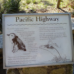
Continue straight: From the viewing area, this walk heads towards the main water views down the 7 sandstone stone steps[11] (each 10cm high). At the bottom of the steps, this walk leads past the ‘Pacific Highway’ information sign[12] and continues down the path for another 20m to come to the main West Head Lookout area[13][14]. Now Veer right to rejoin the main walk .
(0.05km) Lion Island View → West Head Lookout
70 m
2 mins
2m
-7m
Easy track
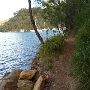
Turn right: From the Lion Island viewing area[15], this walk heads directly away from the face of the ‘West Head Battery’ signs[16], past the top of the steps (initially keeping the steps to the left[17]). The walk soon veers left (at the seats) and follows the narrow (1.3m wide) stone path[18] as it gently winds downhill for about 40m to come to some more bench seats

[19] at the southern edge of the main West Head Lookout. From here the walk veers left and heads along the wide stone lookout area[20], passing some more seats

and information signs[21][22][23][24] coming to a panoramic photo sign naming the key view points[25].
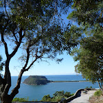
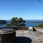
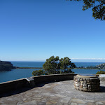
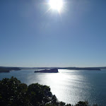
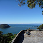
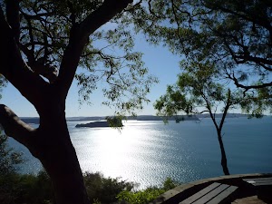
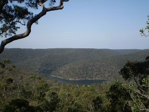
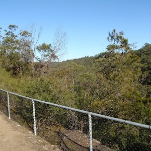
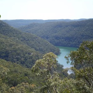
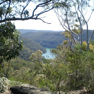
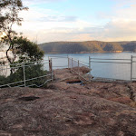
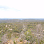
West Head Lookout
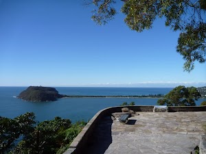
West Head Lookout, Ku-ring-gai Chase National Park is a large paved sandstone viewing area[26] with fantastic views and some interesting interpretive signs[27][28][29][30][31]. The view spans across the Hawkesbury River to Lion Island[32] to Patonga (Central Coast) also across the Pittwater to Barrenjoey Headland[33] and out to sea. The lookout has a series of bench seats
and a low (50cm[34]) stone wall. A lovely place to just sit and soak up the views, and history of the area.
Maps for the West Head Lookout walk
You can download the PDF for this walk to print a map.
These maps below cover the walk and the wider area around the walk, they are worth carrying for safety reasons.
| Broken Bay | 1:25 000 Map Series | 91301N BROKEN BAY | NSW-91301N |
| Ku-ring-gai Chase National Park Tourist Map | 1:40 000 Map Series | CMA Ku-ring-gai Chase National Park Tourist Map | CMA Ku-ring-gai Chase National Park Tourist Map |
| Sydney | 1:100 000 Map Series | 9130 SYDNEY | 9130 |
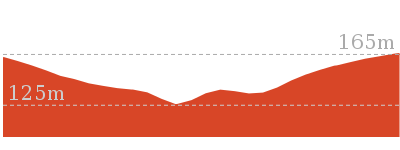
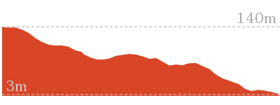
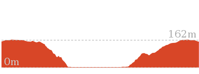
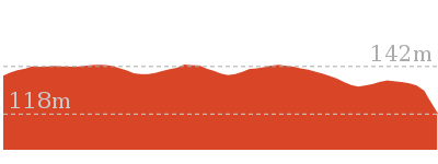
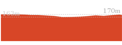
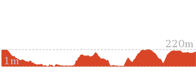
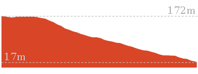
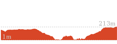
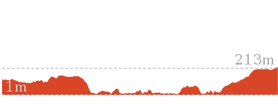
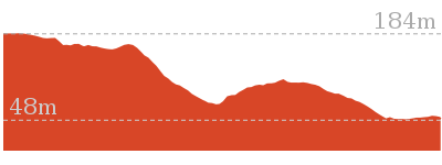
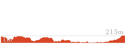
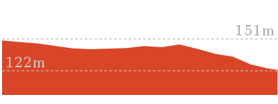
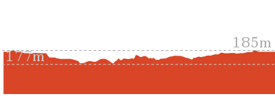
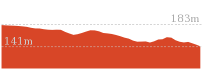
Cross sectional view of the West Head Lookout bushwalking track
Analysis and summary of the altitude variation on the West Head Lookout
Accessibility summary information for the West Head Lookout
Parking: There are 1 designated accessible parking areas on this walk.
Toilets: There are 0 designated accessible toilets on this walk.
Seats: There are 3 places to sit on this walk.
They are on average 50m apart, with a maximum gap of 50m.
Hazards: There are 0 specific noteable accessability related hazards on this walk.
Accessibility Details

Found 0m into this walk


Overview of this walks grade – based on the AS 2156.1 – 2001
Under this standard, a walk is graded based on the most difficult section of the walk.
| Length | 238 m | ||
| Time | 10 mins | ||
| . | |||
| Grade 2/6 Easy track |
AS 2156.1 | Gradient | Flat, no steps (1/6) |
| Quality of track | Clear and well formed track or trail (2/6) | ||
| Signs | Clearly signposted (1/6) | ||
| Experience Required | No experience required (1/6) | ||
| Weather | Weather generally has little impact on safety (1/6) | ||
| Infrastructure | Generally useful facilities (such as fenced cliffs and seats) (1/6) |
Some more details of this walks Grading
Here is a bit more details explaining grading looking at sections of the walk
Gradient
This whole walk, 120m is flat with no steps.
Quality of track
Around 70m of this walk follows a clear and well formed track or trail, whilst the remaining 45m follows a smooth and hardened path.
Signs
This whole walk, 120m is clearly signposted.
Experience Required
This whole walk, 120m requires no previous bushwalking experience.
weather
This whole walk, 120m is not usually affected by severe weather events (that would unexpectedly impact safety and navigation).
Infrastructure
This whole walk, 120m is close to useful facilities (such as fenced cliffs and seats).
Similar walks
A list of walks that share part of the track with the West Head Lookout walk.
Other Nearby walks
A list of walks that start near the West Head Lookout walk.
810 m Circuit
30 mins
Moderate track
403 m Circuit
30 mins
Moderate track
1.1 km Circuit
45 mins
Moderate track
3.7 km Return
1 hr 30 mins
Hard track
3.5 km Circuit
1 hr 45 mins
Hard track
1.9 km Return
1 Hr
Moderate track
2.8 km Circuit
1 hr 30 mins
Very experienced only
2.1 km Return
1 Hr
Moderate track
1.9 km Return
1 Hr
Hard track
2.3 km Return
1 hr 30 mins
Hard track
1.4 km Circuit
45 mins
Moderate track
5.4 km Circuit
3 hrs
Hard track
Plan your trip to and from the walk here
The West Head Lookout walk starts and ends at the End of West Head Rd (gps: -33.578828, 151.30857)
Your main transport option to End of West Head Rd is by;
![]() Car. A park entry fee is required for driving into the park.
Car. A park entry fee is required for driving into the park.
(get details)
Short URL = http://wild.tl/whlw
Gallery images
There are other downloads I am still working on.
You will probably need to login to access these — still all free.
* KML (google earth file)
* GPX (GPS file)
Special Maps/ brochures
* A3 topo maps
* PDF with Lands Topo map base
* PDF with arial image (and map overlay)
I wanted to get the main site live first, this extra stuff will come in time.
Happy walking
Matt 🙂
Kalkari Discovery trail
And Walk
Kalkari Discovery trail

30 mins
798 m Circuit
25 m
Very easy
This pleasant walk starts with a wander through the interesting Kalkari Discovery Center. Enjoy the displays and chat with the volunteers before heading out the back door to find the rest of the walk. The walk follows the concrete path past more information signs and a lovely pond. As you wander through the large fenced enclosure keep an eye out for wallabies, bush turkeys and other animals. The main lookout provides stunning views and well worth spending time to enjoy.


(0km) Kalkari car park → Kalkari Discovery Centre
30 m
1 mins
0m
0m
Very easy
From the Kalkari Discovery Centre car park[1]

(on Ku-ring-gai Chase Rd), this walk heads up the short ramp[2] towards the Visitor Centre[3]. At the top of the ramp this walks goes between 2 bollards[4] (1.3m apart, 93cm high), past the picnic table

, seats

and toilets


to the front door[5] of the Discovery Centre. From here the walk heads through the front door (80cm wide, expandable to 1.7m with a 3cm step[6]) into the Visitor Centre with the information desk[7] (on your right).
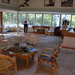
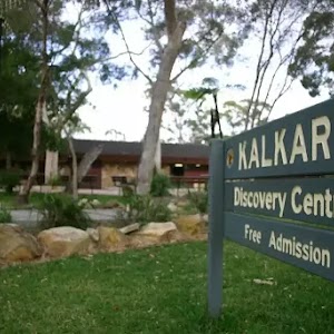
Kalkari Discovery Centre
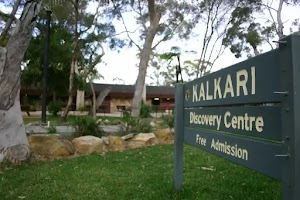
Kalkari Discovery Centre[8] is in the Ku-ring-gai Chase National Park, on Ku-Ring-Gai Chase Road, Mt Colah. The discovery center is staffed by volunteers from Chase Alive. The center boasts some interesting flora and fauna displays inside[9], and out the back is a large enclosure with emu, kangaroos and other native animals roaming around. Take time to explore the wheelchair-accessible circuit within the fence. There are toilets
at the centre. For information, phone 02 9472 9300. There are picnic tables
, seats
and drinking fountain

at the front. There is a large car parking area at the front of the centre with two designated mobility parking bays
.
(0.03km) Kalkari Discovery Centre → Kalkari picnic area
40 m
1 mins
1m
0m
Very easy


(0.07km) Kalkari picnic area → Pond intersection
70 m
1 mins
3m
0m
Very easy
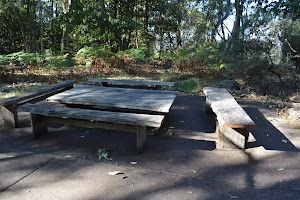
Continue straight: From the picnic tables and seats
[21][22] at the Kalkari picnic area[23], this walk leads along the concrete path, past the sheltered information sign[24] (on your left). This walk then winds along the path gently uphill for 20m, past the ‘Tallowwood’[25] and ‘White Bottlebrush’[26] signs to a timber bridge (2.2m wide)[27] with timber handrails (1m high)[28]. Continue across the bridge over the pond[29] to reach a 3-way intersection[30], marked with a ‘Kalkari Bush Discovery Track’ sign[31].
(0.14km) Pond intersection → Lookout intersection
110 m
2 mins
0m
-12m
Very easy
Veer right: From the intersection[32], this walk follows the ‘one way’ arrow (marked on the ‘Kalkari Bush Discovery Track’ sign[33]) along the concrete path, directly away from the pond, over a small rise then gently downhill. Over the next 60m this walk passes the ‘Sweet Pittosporum’ sign[34] and comes to a seat[35]

(on your left). From the seat this walk continues for another 30m to a 3-way intersection[36], marked with a ‘Sydney Red Gum’ sign[37].
(0.25km) Lookout intersection → The Kalkari Lookout
20 m
1 mins
0m
-9m
Very easy
Kalkari Lookout
The Kalkari Lookout is a timber fenced platform[40] with fantastic views over Cockle Creek[41] and Bobbin Head area. There are a series of seats


providing different ways of enjoying this space. The timber fence is 1m tall and provides a view through the slats[42]. A lovely place to sit and enjoy this amazing national park.
(0.25km) Lookout intersection → Eastern loop int.
110 m
2 mins
5m
-1m
Very easy
Turn left: From the intersection[43], this walk meanders gently uphill, following the concrete path directly away from the lookout, leaving the main valley and fence to your right[44]. This walk then heads downhill, past the ‘Old Man Banksia’[45] and ‘Black She-Oak’[46] signs for 100m, over a rise, to come to a 3-way intersection[47] marked with a ‘No hiding place’ sign[48] (on the left).
(0.35km) Eastern loop int. → Western loop int.
110 m
2 mins
0m
-5m
Very easy
Continue straight: From the intersection, this walk leads gently uphill along the concrete path, following the NPWS arrow sign[49] and under the power lines[50]. This path bends sharply left and goes up and over a rise for the next 80m, past the ‘Grasstrees’ sign[51] (on the left) to the 3-way intersection with a dirt path with timber steps[52] (on the right), just before the scribbly gum tree with the ‘Die’ sign[53] next to it.
(0.46km) Western loop int. → The Kalkari Outlook
30 m
1 mins
0m
-2m
Very easy
Continue straight: From the intersection[54], this walk heads along the concrete path past the scribbly gum tree (with the ‘Die’ sign[55]) and towards the clearing and the fence[56]. The path soon bends left and then leads gently downhill for the next 10m to the seat

[57] on the fenced concrete platform (on the right).
Kalkari Outlook
The Kalkari Outlook is a fenced lookout[58] with views over one of the Kalkari fenced enclosures. At times you will be able to see kangaroos grazing in the clearing. There are two seats

with views over the outlook. The lower end of the platform is natural rock[59] and the fence is about 90cm high[60].
(0.49km) The Kalkari Outlook → Pond intersection
180 m
4 mins
16m
-1m
Very easy
Veer left: From the Kalkari Outlook[61], this walk follows the concrete path uphill and directly away from the view. This walk winds through the open forest (near a house) passing signs for a ‘Grey Gum’[62], a ‘Dwarf Apple’[63] and a ‘Scribbly Gum’[64], to pass straight through the 4-way intersection under the power lines[65]. From here this walk leads gently downhill for 25m to a 3-way intersection[66], marked with a ‘Kalkari Bush Discovery Track’ sign[67].
(0.66km) Pond intersection → Kalkari car park
140 m
3 mins
0m
-4m
Very easy
Turn right: From the intersection[68], this walk heads towards the timber fenced bridge (2.2m wide)[69] with timber handrails (1m high)[70], away from the face of the ‘Kalkari Bush Discovery Track’ sign[71]. This walk then winds for 20m gently downhill, leaving the pond on your right, passing the ‘White Bottlebrush’[72], ‘Tallowwood’[73] signs and a sheltered information sign[74] (on your right) to reach the picnic tables and seats
[75][76] at the Kalkari picnic area[77].
Continue straight: From picnic tables and seats
[78][79] at the Kalkari picnic area[80], this walk leads along the wide concrete path toward the Kalkari Discovery Centre[81]. After 35m this walk leads through the glass back door[82], straight to the front desk[83] (inside of the Kalkari Discovery Centre).
Continue straight: From the information desk[84] at the Kalkari Discovery Centre[85] this walk leads down the hallway[86] (on the car park side) to the front door (80cm wide, expandable to 1.7m with a 3cm step[87]). Walk heads through the door, veers right (away from the toilets
) then past seats
and picnic table
, down the short ramp[88], between 2 bollards[89] (1.3m apart, 93cm high), to the car park[90]
(on Ku-ring-gai Chase Rd).
Maps for the Kalkari Discovery trail walk
You can download the PDF for this walk to print a map.
These maps below cover the walk and the wider area around the walk, they are worth carrying for safety reasons.
| Hornsby | 1:25 000 Map Series | 91304S HORNSBY | NSW-91304S |
| Ku-ring-gai Chase National Park Tourist Map | 1:40 000 Map Series | CMA Ku-ring-gai Chase National Park Tourist Map | CMA Ku-ring-gai Chase National Park Tourist Map |
| Sydney | 1:100 000 Map Series | 9130 SYDNEY | 9130 |
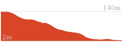
Cross sectional view of the Kalkari Discovery trail bushwalking track
Analysis and summary of the altitude variation on the Kalkari Discovery trail
Accessibility summary information for the Kalkari Discovery trail
Parking: There are 1 designated accessible parking areas on this walk.
Toilets: There are 0 designated accessible toilets on this walk.
Seats: There are 7 places to sit on this walk.
They are on average 80m apart, with a maximum gap of 270m.
Hazards: There are 0 specific noteable accessability related hazards on this walk.
Accessibility Details
Found 0m into this walk

Found 10m into this walk


Found 20m into this walk

Found 20m into this walk

Found 70m into this walk


Overview of this walks grade – based on the AS 2156.1 – 2001
Under this standard, a walk is graded based on the most difficult section of the walk.
| Length | 798 m | ||
| Time | 30 mins | ||
| . | |||
| Grade 1/6 Very easy |
AS 2156.1 | Gradient | Flat, no steps (1/6) |
| Quality of track | Smooth and hardened path (1/6) | ||
| Signs | Clearly signposted (1/6) | ||
| Experience Required | No experience required (1/6) | ||
| Weather | Weather generally has little impact on safety (1/6) | ||
| Infrastructure | Generally useful facilities (such as fenced cliffs and seats) (1/6) |
Some more details of this walks Grading
Here is a bit more details explaining grading looking at sections of the walk
Gradient
This whole walk, 800m is flat with no steps.
Quality of track
This whole walk, 800m follows a smooth and hardened path.
Signs
This whole walk, 800m is clearly signposted.
Experience Required
This whole walk, 800m requires no previous bushwalking experience.
weather
This whole walk, 800m is not usually affected by severe weather events (that would unexpectedly impact safety and navigation).
Infrastructure
This whole walk, 800m is close to useful facilities (such as fenced cliffs and seats).
Similar walks
A list of walks that share part of the track with the Kalkari Discovery trail walk.
Other Nearby walks
A list of walks that start near the Kalkari Discovery trail walk.

5.2 km Circuit
2 hrs 15 mins
Hard track
552 m Return
15 mins
Very easy
1.6 km Return
40 mins
Moderate track
4.4 km Return
2 hrs
Moderate track

1.1 km Return
1 Hr
Hard track
5.3 km One way
2 hrs 30 mins
Hard track
3.9 km Circuit
2 hrs
Hard track
9.7 km One way
4 hrs 15 mins
Hard track
17.2 km One way
8 hrs
Hard track
9.4 km Return
4 hrs
Hard track

2.5 km Return
1 hr 30 mins
Moderate track

Plan your trip to and from the walk here
The Kalkari Discovery trail walk starts and ends at the Kalkari car park (gps: -33.665258, 151.14905)
Your main transport option to Kalkari car park is by;
![]() Car. Parking fees apply in the area.
Car. Parking fees apply in the area.
(get details)
Short URL = http://wild.tl/kdt
Gallery images
There are other downloads I am still working on.
You will probably need to login to access these — still all free.
* KML (google earth file)
* GPX (GPS file)
Special Maps/ brochures
* A3 topo maps
* PDF with Lands Topo map base
* PDF with arial image (and map overlay)
I wanted to get the main site live first, this extra stuff will come in time.
Happy walking
Matt 🙂
Wahroonga to Mt Kuring-gai
And Walk
Wahroonga to Mt Kuring-gai

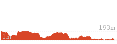
5 hrs 30 mins
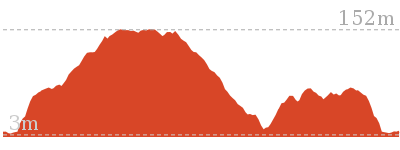
14.7 km One way
607 m
Hard track
Starting with a walk through the streets of Wahroonga, this walk then heads bush, following the Gibberagong Track to Bobbin Head. After a picnic or a bite to eat from the kiosk, the walk then heads up the Birrawanna track to lead to Apple Tree Bay. From here the track follows the picturesque Cowan Creek for a while before heading up the ridge to Mt Kuring-gai Station.


(0km) Wahroonga Railway Station → End of Grosvenor St
2.9 km
50 mins
32m
-53m
Very easy
From Wahroonga Station, this walk heads north along Illoura Av, away from the round-about. The walk soon crosses Millewa Ave at the pedestrian crossing, then passes alongside Wahroonga Park (to the left). At the end of the park, the walk turns right into Stuart St (at the round-about) then left onto Cleveland St at the next roundabout. At the end of Cleveland St, the walk turns right onto Burns Road then immediately left onto Grosvenor St. The walk then follows Grosvenor St for approximately 2km to the end, where there is a green gate at the start of a management trail.
(2.93km) End of Grosvenor Rd → Gibberagong Track Lookout Int.
120 m
2 mins
3m
-4m
Easy track
Continue straight: From the very end of Grosvenor Rd[1] (Wahroonga), this walk follows the management trail gently downhill around the locked green metal gate[2] and past the ‘No through road’ sign[3]. The trail leads through a dip among a scribly gum forest for just over 100m to an intersection with a track (on your left)
marked with a ‘Ku-ring-gai Chase National Park – Gibberagon Trail sign[4].
marked with a ‘Ku-ring-gai Chase National Park – Gibberagon Trail sign[4].
(3.05km) Gibberagong Track Lookout Int. → End of Gibberagong trail
1.2 km
20 mins
5m
-22m
Easy track
Veer right: From the intersection, this walk follows the NPWS arrow post[5] gently uphill along the wide trail, following the ridge line over a gently rise. After about 350m this walk leads past a small clearing[6] (on your right). Here the walk continue downhill through the scribbly gum forest[7] for another 900m to where the trail bends sharply right[8] (to end) and comes to an intersection with the fairly wide Gibberagon Track[9] (on your left, part way around the bend).
(4.29km) End of Gibberagong trail → Gibberagong AND Murrua Track Int.
800 m
18 mins
7m
-103m
Hard track
Veer left: From the intersection[10], this walk follows the fairly wide Gibberagong Track[11] north east, gently downhill. The track soon starts to narrow and lead a little steeper down a series of timber steps[12] for about 80m before heading down through a notably steep rocky pass[13]. Here the track continues to winds down the ridge moderately steeply for just shy of 250m, to step down a rock pass around a right hand hair-pin bend[14]. Then just 30m later the track bends sharply left at another hair-pin bend[15] then just shy of 50m later
the track bends sharply right[16] again. From here the track leads down the series of timber and stone steps through then casurina forest[17] for about 200m to come to a ‘Bobbin Head’ sign[18], just before distinct gully. Here the walk veers left (following the arrow on the sign) and heads down the bank to cross Lovers Jump Creek[19] on the mossy rocks with carved steps[20]. After heading up the other bank this walk follows the clear track near Cockle Creek for just shy of 100m to a more open section providing clearer views over the creek[21] and the southern section of Gibberagong Waterholes. From here the track then leads further down the widening valley through the tall eucalypt and stringy bark forest[22] for 100m to a intersection with a faint track (on your right) at a tall smooth bark angophera[23], marked with an obvious sign pointing back ‘To Grosvenor Street’.
the track bends sharply right[16] again. From here the track leads down the series of timber and stone steps through then casurina forest[17] for about 200m to come to a ‘Bobbin Head’ sign[18], just before distinct gully. Here the walk veers left (following the arrow on the sign) and heads down the bank to cross Lovers Jump Creek[19] on the mossy rocks with carved steps[20]. After heading up the other bank this walk follows the clear track near Cockle Creek for just shy of 100m to a more open section providing clearer views over the creek[21] and the southern section of Gibberagong Waterholes. From here the track then leads further down the widening valley through the tall eucalypt and stringy bark forest[22] for 100m to a intersection with a faint track (on your right) at a tall smooth bark angophera[23], marked with an obvious sign pointing back ‘To Grosvenor Street’.
(5.09km) Int of Gibberagong and Murrua Link Tracks → Gibberagong waterhole
40 m
1 mins
1m
-2m
Moderate track
Continue straight: From the intersection, beside the large smooth bark angophera[24], this walk follows the ‘To Bobbin Head’ sign along the clear track gently downhill, keeping the creek a short distance to your left, for about 20m to pass a section of metal fencing[25] propped up by a tree. The walk continues for another 10m or so to come to a flat area beside[26] the northern end of Gibberagong waterholes[27], this is just before the track crosses a small side creek[28].
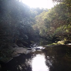
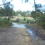
Gibberagong waterhole
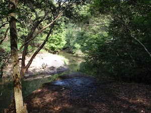
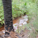
Gibberagong waterhole is an informal name for a wide section of Cockle Creek that run for over 150m north of the confluence with Lovers Jump creek. This secluded and shady spot is a great place to sit and enjoy the waterholes, cascading water and the view to the sandy banks on the other side. If you sit quietly enough you may see lyrebirds scratching through the bush by the creek.
(5.12km) Gibberagong waterhole → Int of Bobbin Head and Rainforest tracks
3.2 km
1 hr 9 mins
129m
-170m
Moderate track
Continue straight: From beside[29] the northern end of Gibberagong waterholes[30], this walk follow the track along the waters edge, keeping Cockle Creek to your left. After 25m this walk crosses a small side creek[31] them follows the track gently uphill for just shy of 100m to pass a rock platform[32] (on your left), with a good view over this bend in Cockle Creek[33]. The track continues up the side of the hill for another 100m to pass alongside an 2m high natural rock wall[34] then about 120m later this walk leads back down close to the edge of the creek[35]. Just over 120m later the track leads under two tall over hangs[36][37] (the first overhang has a notable hole high in the roof[38]), then just over 100m later the track leads under a set of power lines[39] (a bit tricky to see through the canopy). From here the track continues to gently undulate along the side of the hill, in view of the creek, for just over 1km to come back down to a pleasant, fairly open forest[40] on a sandy bank beside a long pool[41] on Cockle Creek (with a few small cascades upstream[42]). The track continues downstream for another 100m to cross over a mostly but mostly flat rock platform[43] then over the next 200m the track leads up the side of the hill to cross a shallow gully[44] with several tall palms among the mostly tall eucalypt forest[45]. Here the track passes under a two sets of high tension power lines[46]. The track continues to undulate along the side of hill for another 200m to lead down to to the rocky creeks edge again[47], near the upper reaches of the tidal section of the creek[48]. From here the now mostly flat track continues downstream beside the creek for 300m to come to a notably flat and open sandy area with some bracken fern beside the creek[49]. The track then leads alongside the tidal section of Cockle Creek among the mixed forest of casuarina[50], grass trees[51] and tall eucalypt[52] for just shy of 300m to then head through a 200m long section section of mangroves[53] with a scattering of open casuarina forest[54]. Here the rocky track leads up the side of the hill, up a few steps to the top of the ridge line. Just as the track comes to the top of this hill it bends right and comes to a three-way intersection[55], where a ‘Wahroonga 5km’ sign[56] points back down the track.
(8.32km) Int of Bobbin Head and Rainforest tracks → Bobbin Head Rainforest
190 m
5 mins
15m
-7m
Moderate track
Continue straight: From the intersection, this walk follows the ‘Rainforest 500m’ sign[57] gently uphill along the clear track heading south east. After about 60m the track starts to lead gently down the side of the hill among the grass tree and eucalypt forest[58] for about 100m before leading down a series of timber steps into the more densely forest gully[59]. Here the walk comes to a sandstone rock bed[60] and creek in a pleasant rainforest setting[61]. At the end of this side trip, retrace your steps back to the main walk then Turn right.
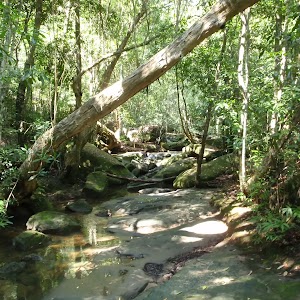
Bobbin Head Rainforest
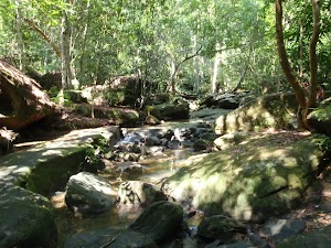
A well-protected piece of rainforest is found just a short walk from the popular Bobbin Head picnic area in Ku-Ring-Gai Chase National Park. The rainforest is distinct when compared to much of the dry eucalypt forests that dominate the area. The rainforest is beside a small creek, just below Bobbin Head Road, and is a safe haven for many birds that frequent the area.
(8.32km) Int of Bobbin Head and Rainforest tracks → Aboriginal Axe Grindings
20 m
0m
-3m
Easy track
Aboriginal Axe Grindings
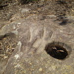
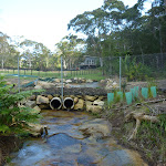
This protected site clearly shows 23 oval-shaped grooves that were worn by Indigenous Australian people, making axe heads from hard rock. Using a blank axe head, the Aboriginal people would use this rock platform, with water from the nearby creek, to sharpen the stone into a useful tool. The rubbing ground the axe head to a sharp edge and left behind these tell-tale signs. More info.
(8.35km) Aboriginal Axe Grindings → South End of Bobbin Head Park
600 m
13 mins
25m
-32m
Moderate track
Continue straight: From the Aboriginal ‘Axe Grinding Grooves’ site[64] this walk follows the track gently downhill along the ridge, initially keeping the grinding site to your right. After about 20m this walk heads down some sandstone steps[65] the continues for another 60m along the sandy track down more steps[66] then up to the top of a small rise[67] where the is a unfenced[68] view over the water[69] (just off the track to your left). Here the walk continues generally down along the ridge for just shy of 300m where the track leads over a rock platform before heading down some steps that lead through a cleft in the rock[70]. The track then leads past a small sandstone overhang[71] to head down a timber ramp to find a timber boardwalk, marked with a ‘More?’ sign[72].
Continue straight: From the ‘More? you want more?’ information sign[73], this walk follows the timber boardwalk as it winds among the mangroves and saltmarsh[74]. Keep an eye out for missing boards
Continue straight: From the ‘More? you want more?’ information sign[73], this walk follows the timber boardwalk as it winds among the mangroves and saltmarsh[74]. Keep an eye out for missing boards

and the lack of side capping on the edge of the boardwalk
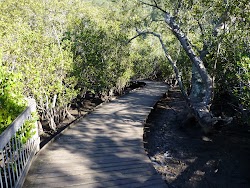
. The boardwalk leads
past the ‘Land Developers?’[75] and ‘Natural Recycler’[76] information signs as it winds for about 100m to a fenced viewing area[77] marked with a ‘Teeming with life!’ information sign[78].
Continue straight: From the viewing area[79], this walk follows the fenced timber boardwalk keeping the main body of visible water to your right. After about 25m this walk crossed Cockle Creek on a cable-stayed foot bridge[80]

. There are some great water and cliff views from the bridge. On the other side the footpath the path bends right to find a sandstone cave (with a 1.9m clearance[81]) with a ‘Rock Solid?’ information sign[82]. Here the walk continues along the patterned concrete path for about 20m to pass a bench seat

, then another 20m there is another similar bench seat
. A short distance later the path leads past the sheltered ‘Welcome to the Mangrove Boardwalk & Gibberagong Track’ information sign[83] (on your left). This walk then continues along the footpath for another 20m to the car park[84]


and a small constructed sandstone wall with a ‘Gibberagong Track. Mangrove Boardwalk.’ sign[85]. There are a number of picnic tables


beside the car park.
(8.95km) South End of Bobbin Head Park → Bobbin Head Kiosk
510 m
9 mins
10m
-5m
Very easy
Veer right: From the southern end of the car park, this walk heads away from the face of the ‘Gibberagong Track Mangrove Boardwalk’ sign[86] following the asphalt footpath[87] beside the car park, keeping the water to your right. After about 100m this walk heads past the signposted ‘Canoe Launch Area’[88] then continues along the compacted dirt foreshore path[89] for 100m where the path becomes asphalt again[90] to lead past the children’s play ground[91] for just over 50m to the sandstone steps[92] (that provide access to Cockle Creek). The walk continues along the foreshore path for almost 200m until just before the road bridge over Cockle Creek[93], where the now brick paved path bends left[94]. Here the walk crosses the car park entrance[95] and continues straight, over the grass to the back of ‘Bobbin Inn’ cafe, just beside Ku-Ring-Gai Chase Rd (on your right).
Bobbin Head
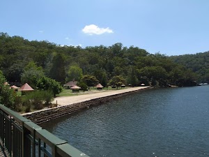
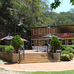
Bobbin Head is a historic recreation area which is still popular today, suiting the needs of many people. At the center of the Bobbin Head area is the old ‘Bobbin Inn’[96], built in the 1930s – it is now the park information center and cafe[97]. The area is popular with picnickers, boaters, walkers, canoeists, family groups and people who like to fish. Bobbin Head is roughly divided into three sections (north, south and east).
Southern Bobbin Head is a popular picnic area for families and large groups. The area is surrounded by a car park[98] and dotted with picnic tables[99][100], electric BBQs[101], shelters and a large playground[102]. There are toilets[103]
Southern Bobbin Head is a popular picnic area for families and large groups. The area is surrounded by a car park[98] and dotted with picnic tables[99][100], electric BBQs[101], shelters and a large playground[102]. There are toilets[103]

nearby, and ‘The Station’ is a sheltered accessible area with BBQ and tables[104][105] that can be booked NPWS.
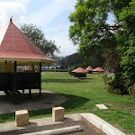
The northern Bobbin Head (Orchard Park)[107] area is a more formal picnic area. There is a large picnic shelter[108], surrounded by 14 smaller octagonal shelters[109], each of these divided into 4 walled-off compartments, ideal for small groups.
The eastern side of Bobbin Head is dominated by the Empire Marina[110] and a public wharf. The marina is home to a nice restaurant[111] and public toilets[112].
Bobbin Inn Cafe
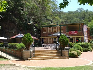
At the centre of Bobbin Head picnic area, in the old ‘Bobbin Inn’ building[113], is a cafe offering inside and outdoor dining[114], and a range of foods and drinks. Food includes fish and chips, wraps, focaccia, sandwiches and snack foods. Tea, coffee and cold drinks are also on offer. Opening hours are 9 – 4pm Mon to Fri (closed Tuesdays) & 9 – 5pm weekends. For more information, phone the cafe on 9457 7170.
The NPWS Bobbin Head Information Centre is open 7 days a week (closed Christmas Day) 10 – 4pm (closed 12 – 12:30pm lunch).
Ramp access[115][116] available on the southwestern corner of the building. Ramp access to the information centre through the cafe.
The NPWS Bobbin Head Information Centre is open 7 days a week (closed Christmas Day) 10 – 4pm (closed 12 – 12:30pm lunch).
Ramp access[115][116] available on the southwestern corner of the building. Ramp access to the information centre through the cafe.
(9.45km) Bobbin Inn Cafe → Bottom of the Birrawana track steps
160 m
4 mins
30m
0m
Easy track
Continue straight: From the ‘Bobbin Inn’ cafe[117], this walk heads to the front of the building to the ‘Information Centre’ main entrance. From here this walk follows the ‘Birrawana Loop Track’[118] alongside the road a few meters to find a metal ‘Welcome to the Cockle Creek Lookout Track’ sign and map[119]. Now the walk follows the track behind the safety barrier (keeping the road to your right) for about 70m to cross a small culverted creek[120] and pass a few old a couple of picnic tables[121] in a shaded and mossy gully. This walk continues for another 30m behind the safety barrier[122] to come to the bottom of the signposted ‘Birrawanna Track’[123] steps.
(9.61km) Int of Birrawana track and Ku-Ring-Gai Chase Road → Int of Birrawana and Cockle Creek Lookout tracks
300 m
7 mins
38m
-10m
Hard track
Veer left: From beside Ku-Ring-Gai Chase Road[124], this walk heads down a few steps to cross a small flat concrete bridge[125], to then follow the ‘Birrawanna Track’ sign[126] up the timber steps. This walk leads quite steeply up the track as it zig-zags up a series of timber and rock steps[127][128] for just over 300m to find the top of small rocky ridge[129]. Here the walk leads down a series of timber steps[130] for about 50m to cross a moist gully[131] that is home to a disused telegraph pole[132]. Now this walk follows the clear rocky track leads uphill[133] for just shy of 200m to come to a faint intersection at the top of the ridge[134] (where the lookout track is on your right).
(9.91km) Int of Birrawana and Cockle Creek Lookout tracks → Cockle Creek Lookout
110 m
3 mins
1m
-15m
Moderate track
Turn right: From the intersection, this walk follows the rocky track, east along the top of the ridgeline towards the rocky outcrop[135]. After about 50m this walk passes through a gap between two large rock outcrops[136], then around another rock to wind gently down the hill for just shy of 50m to come to an unfenced rock ledge overlooking Cockle Creek[137]. At the end of this side trip, retrace your steps back to the main walk then Turn right.
Cockle Creek Lookout
Cockle Creek Lookout is an informal lookout with no facilities, on the Birrawanna track in Ku-Ring-Gai Chase National Park. The lookout provides Glimpses of Cockle and Cowan Creeks. The area is surrounded by some beautiful gum trees and rock boulders, making it a nice place to sit and reflect on the surroundings.
(9.91km) Int of Birrawana and Cockle Creek Lookout tracks → National Parks Regional Office
420 m
10 mins
26m
-27m
Moderate track
Continue straight: From the intersection, this walk heads north gently down hill for a few meters to follow an NPWS arrow post[138] along the clear track. After just shy of 100m this track bends left[139] to then gently undulate along the side of the hill (with the road down to your right)[140] for about 300m. Here the track mostly flattens out and contours around the side of the hill[141] for about 150m to then lead up a very gently hill to a signposted three way intersection. The intersection is beside a small clearing behind the regional office (on your right) and is marked with a ‘Cockle Creek Lookout’ and ‘Bobbin Head’ sign[142] pointing back along the track.
Veer right: From the intersection, the walk head gently uphill across the grassy clearing[143], veering left a little to head across the car park and come the the driveway entrance[144] of the sandstone National Parks Regional Office building.
Veer right: From the intersection, the walk head gently uphill across the grassy clearing[143], veering left a little to head across the car park and come the the driveway entrance[144] of the sandstone National Parks Regional Office building.
NPWS North Sydney Regional Office
The NPWS North Sydney Regional Office is a lovely stone building on Bobbin Head Road at one of the trackheads for Birrawanna loop track. There is a car park and an open grassy area. On the opposite side of the road is the Apple Tree Flat Picnic Area with a few picnic tables. Other than this, there are no public facilities.
(10.32km) National Parks Regional Office → Apple Tree Flat Picnic Area
40 m
1 mins
0m
-3m
Easy track
Veer right: From the the NPWS Regional office, this walk heads out of the car park and crosses Ku-Ring-Gai Chase Road, veering right to find a small clearing on the other side[145]. From the clearing, the walk heads down some stone steps to almost immediately come to an intersession marked with an ‘Apple Tree Flat’ sign[146] just beside the picnic area[147].
Apple Tree Flat Picnic Area
Apple Tree Flat Picnic Area is opposite the NPWS North Sydney Regional office on Bobbin Head Rd, in Ku-Ring-Gai Chase national park. The small picnic area should not be confused with the more popular Apple Tree Bay Picnic Area and boat ramp further down the hill. The picnic area provides three bench platforms for sitting and dining. There is also a small, open grassy area and some large trees providing shade.
(10.37km) Apple Tree Flat Picnic Area → Apple Tree Flat Lookout
70 m
2 mins
0m
-12m
Easy track
Continue straight: From the intersection, this walk heads behind the ‘Apple Tree Flat’ sign[148] to follow the flat gravel path, past the picnic tables[149]. After about 30m this walk heads down a few stone steps[150] then just 30m later the path comes to a to the fenced Lookout[151] and views[152] over Cowan Creek. At the end of this side trip, retrace your steps back to the main walk then Turn right.
Apple Tree Flat Lookout
Apple Tree Flat Lookout is a small fenced lookout high up the hill overlooking Apple Tree Bay and Cowan creek. The view is filtered through the tall gum trees. Being perched on a rock platform, the views are great. The lookout is not far from Bobbin Head Rd, near the NPWS North Sydney Regional Office, in Ku-Ring-Gai Chase National Park.
(10.37km) Apple Tree Flat Picnic Area → Int of Apple Tree Bay Road and Apple Tree Flat bushtrack.
230 m
7 mins
1m
-60m
Moderate track
Turn left : From the intersection, this walk follows the ‘Apple Tree Bay’ sign[153] downhill along the clear track. The track soon bends left then after 30m veers right at a faint intersection to follow the ‘HH’ AND NPWS arrow post further downhill[154]. The track the winds down the side of a gully[155] for about 200m to pass through a sharp left hand hair pin bend[156]. Here the walk continues downhill for just over 30m to an intersection with the sealed Apple Tree Bay road[157] where a ‘Regional Office’ sign points back up the hill[158].
(10.6km) Int of Apple Tree Bay Road and Harbour to Hawkesbury Track → Apple Tree Bay Kiosk
170 m
3 mins
4m
-3m
Very easy
Turn left: From the intersection at the bottom of the signposted ‘Regional Office’ track[159], this walk follows the sealed road gently downhill keeping the water and main valley to your right. After about 30m the road leads past a footpath (to a small gated marina[160], on your right) to continue down the road for 150m to the Apple Tree Bay car park[161]. Just across from the entrance this walk comes to a Kiosk and ‘Welcome to Apple Tree Bay’ sign[162].
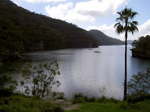
Apple Tree Bay
Apple Tree Bay, in Ku-Ring-Gai Chase national park, has a popular boat ramp for accessing Cowan creek and plenty of parking. The area has kiosk, electric BBQ’s, picnic benches, toilets, drinking water, garbage facilities, and shade provided by trees. If you are after a quiet spot, head to the western end (away from the boat ramp, past the BBQ’s), just beyond the car park, to a lovely clearing by the water. The area is closed between sunset and sunrise.
The kiosk/cafe[163] is open on weekend and services hot and cold drinks, ice creams and some hot food.
The kiosk/cafe[163] is open on weekend and services hot and cold drinks, ice creams and some hot food.
(10.77km) Apple Tree Bay → Int of Mt Kuring-gai and Berowra Tracks
940 m
26 mins
82m
-66m
Moderate track
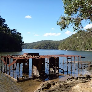
Turn right: From the kiosk[164], this walk heads across the eastern end of the car park[165], keeping the water to your right for just shy of 100m to pass the top of the boat ramp[166] and find the sheltered ‘Information’ sign[167]. Here the walk crosses Apple Tree Creek on the timber bridge[168] to find a small clearing and picnic area where this walk turns right following the ‘Berowra Track’ sign[169]. The walk soon leaves the metal fence and follows the rocky track and stone steps[170] for about 100m where the track then mostly flattens out[171] for another 100m to cross a small rock gully and grove of sassafras[172]. The track then crosses another gully and continues along the shore for just over 200m leaving the Apple Tree Bay where the track veers left over a small rise using some timber steps[173]. From here this walk continues along the shoreline in a similar manor for 300m to come to a constructed stone wall[174] and series of disused stone steps (on your left)[175]. This is the site of the historic Woodnutts Boatshed that was built in 1910. The rusting water tank and a few other relics remain[177].
Here the walk continues along the clear track along the shoreline for another 40m to the intersection at the bottom of the signposted ‘Mt Ku-ring-gai Track’[178] (on your left).
Here the walk continues along the clear track along the shoreline for another 40m to the intersection at the bottom of the signposted ‘Mt Ku-ring-gai Track’[178] (on your left).
(11.7km) Int of Mt Kuring-gai and Berowra Tracks → Int of Lookout and Mt Kuring-gai Tracks
1.9 km
49 mins
190m
-13m
Hard track
Turn left : From the intersection, this walk follows the ‘MT Ku-ring-gai Track’ sign[179] up the rock and timber steps and past the small overhang[180]. The track leads fairly steeply up for 80m to then bend sharply right[181] and continue fairly steeply for another 200m to pass a natural rock wall[182] (on your left). Just 20m past this wall the track comes to a small flat area[183] with good views over Cowan Creek[184]. Here the walk continues more gently uphill along the rocky ridge line[185] for 300m where the track completely flattens out to pass along the side of a small hill[186] (on your left). Over the next 600m the track leads down across a saddle then up along the ridge to bend right onto[187] an exposed rock platform[188]. From there the sandy track soon bends left again to follow the ridge uphill for 100m to pass a small sandstone overhang[189] then continue up a long set of stone steps[190] where the sandy track mostly flattens out again[191]. Soon the track starts heading up more stone steps [192] for about 400m to pass between a large boulder (on your left) and along rock wall (on your right)[193]. At the end of this rock wall the track bends right and leads up the stone steps through the cleft in the rock[194] where the then mostly flat wide sandy track leads gently uphill for 250m to find a three-way intersection[195]
marked with a NPWS arrow post[196].
marked with a NPWS arrow post[196].
(13.64km) Int of viewpoint and Mt Kuring-gai Tracks → Apple Tree Bay Viewpoint
110 m
2 mins
0m
-14m
Moderate track
Turn left : From the intersection, the walk heads east away from the main trail[197] to follow the wide sandy track gently downhill. The track begins to narrow[198] and after about 100m the now rocky track comes to an unfenced rock platform[199] with good views down over Apple Tree Bay and down along Cowan Creek valley[200]. At the end of this side trip, retrace your steps back to the main walk then Veer left.
Mt Ku-Ring-Gai Track Lookout
This informal, unfenced lookout is perched on some rocks, not far from the Mt Ku-Ring-Gai Track. It provides views across the valley to Cowan Creek and over much of Ku-Ring-Gai Chase National Park.
(13.64km) Int of Lookout and Mt Kuringai Tracks → Corner of Harwood Avenue and Young Street
650 m
11 mins
5m
-12m
Easy track
Continue straight: From the intersection, this walk heads away from the face of the face of the NPWS arrow post[201] to head south west over a small rise and along the sandy management trail. The trail passes through open wooded forest for just over 600m to pass a ‘Ku-ring-gai Chase National Park – Mt Kuring gai Track’ sign[202] as the trail bends right where this walk heads around the green metal National Park gate[203]. Here the walk heads past a few houses to find the intersection of ‘Harwood Ave’ and ‘Young St’[204] (Mt Kuring-gai).
(14.29km) Corner of Harwood Avenue and Young Street → Mt Kuring-gai Railway Station
400 m
8 mins
19m
-1m
Easy track
Continue straight: From the corner of Harwood Avenue and Young Street, this walk follows Harwood Ave downhill along the footpath. The footpath then leads up past a ‘Seaview St’[205] and across ‘Low St’[206] to continue to the end of Harwood Ave to find a footbridge[207]. Here the walk crosses the the F3 freeway using the caged foot bridge[208] to head down the steps into a concrete tunnel[209]. Part way through the tunnel this walk comes to an intersection at the bottom of the steps at Mt Kuring-gai Railway Station. Here there is a sign that points back to ‘Mt Ku-ring-gai Walking Track’[210]
Maps for the Wahroonga to Mt Kuring-gai walk
You can download the PDF for this walk to print a map.
These maps below cover the walk and the wider area around the walk, they are worth carrying for safety reasons.
| Hornsby | 1:25 000 Map Series | 91304S HORNSBY | NSW-91304S |
| Ku-ring-gai Chase National Park Tourist Map | 1:40 000 Map Series | CMA Ku-ring-gai Chase National Park Tourist Map | CMA Ku-ring-gai Chase National Park Tourist Map |
| Sydney | 1:100 000 Map Series | 9130 SYDNEY | 9130 |
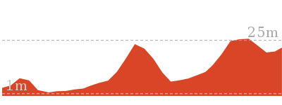
Cross sectional view of the Wahroonga to Mt Kuring-gai bushwalking track
Analysis and summary of the altitude variation on the Wahroonga to Mt Kuring-gai
Overview of this walks grade – based on the AS 2156.1 – 2001
Under this standard, a walk is graded based on the most difficult section of the walk.
| Length | 14.7 km | ||
| Time | 5 hrs 30 mins | ||
| . | |||
| Grade 4/6 Hard track |
AS 2156.1 | Gradient | Very steep (4/6) |
| Quality of track | Formed track, with some branches and other obstacles (3/6) | ||
| Signs | Directional signs along the way (3/6) | ||
| Experience Required | Some bushwalking experience recommended (3/6) | ||
| Weather | Storms may impact on navigation and safety (3/6) | ||
| Infrastructure | Limited facilities, not all cliffs are fenced (3/6) |
Some more details of this walks Grading
Here is a bit more details explaining grading looking at sections of the walk
Gradient
7km of this walk has gentle hills with occasional steps and another 4.5km is flat with no steps. Whilst another 3km is very steep and the remaining 230m has short steep hills.
Quality of track
8km of this walk follows a formed track, with some branches and other obstacles and another 4.3km follows a smooth and hardened path. The remaining (2.3km) follows a clear and well formed track or trail.
Signs
Around 8km of this walk is clearly signposted, whilst the remaining 7km has directional signs at most intersection.
Experience Required
Around 8km of this walk requires no previous bushwalking experience, whilst the remaining 7km requires some bushwalking experience.
weather
Around 11km of this walk is not usually affected by severe weather events (that would unexpectedly impact safety and navigation), whilst the remaining 4km is affected by storms that may impact your navigation and safety.
Infrastructure
Around 8km of this walk is close to useful facilities (such as fenced cliffs and seats), whilst the remaining 6km has limited facilities (such as not all cliffs fenced).
Similar walks
A list of walks that share part of the track with the Wahroonga to Mt Kuring-gai walk.
552 m Return
15 mins
Very easy
1.1 km Return
1 Hr
Hard track
1.6 km Return
40 mins
Moderate track
3.9 km Circuit
2 hrs
Hard track
5.2 km Circuit
2 hrs 15 mins
Hard track
5.3 km One way
2 hrs 30 mins
Hard track

6.5 km One way
2 hrs 30 mins
Hard track
8.7 km One way
4 hrs
Hard track
9.4 km One way
4 hrs 30 mins
Hard track

10.7 km One way
4 hrs 45 mins
Hard track
11 km One way
4 hrs 30 mins
Hard track
12.9 km Circuit
5 hrs
Hard track
14.6 km One way
6 hrs 30 mins
Hard track
Other Nearby walks
A list of walks that start near the Wahroonga to Mt Kuring-gai walk.
9.4 km One way
4 hrs 15 mins
Moderate track

6.6 km One way
2 hrs 45 mins
Moderate track
4.2 km One way
1 hr 45 mins
Moderate track

6.7 km Circuit
3 hrs
Hard track
16.1 km One way
6 hrs 45 mins
Hard track
43.1 km One way
3 Days
Hard track
5.6 km Return
2 hrs 30 mins
Hard track
9.7 km One way
4 hrs
Hard track
22.3 km One way
9 hrs
Hard track
8.6 km One way
3 hrs 45 mins
Hard track
828 m Return
30 mins
Moderate track

1.8 km One way
50 mins
Moderate track
Plan your trip to and from the walk here
The Wahroonga to Mt Kuring-gai walk starts at the Wahroonga Railway Station (gps: -33.717619, 151.1171)
Your transport options to Wahroonga Railway Station are by;
![]() Train. (get details)
Train. (get details)
![]() Bus. (get details)
Bus. (get details)
![]() Car. There is free parking available.
Car. There is free parking available.
(get details)
![]() Train. (get details)
Train. (get details)
The Wahroonga to Mt Kuring-gai ends at the Mt Kuring-gai Railway Station (gps: -33.653814, 151.13674)
Your transport options to Mt Kuring-gai Railway Station are by;
![]() Bus. (get details)
Bus. (get details)
![]() Car. There is free parking available.
Car. There is free parking available.
(get details)
Short URL = http://wild.tl/wtmk
Gallery images
There are other downloads I am still working on.
You will probably need to login to access these — still all free.
* KML (google earth file)
* GPX (GPS file)
Special Maps/ brochures
* A3 topo maps
* PDF with Lands Topo map base
* PDF with arial image (and map overlay)
I wanted to get the main site live first, this extra stuff will come in time.
Happy walking
Matt 🙂
The Perimeter Trail to Smiths Creek
And Walk
The Perimeter Trail to Smiths Creek

6 hrs
16.1 km Return
576 m
Moderate track
This walk to Smiths Creek follows a wide trail for most of the way, however it is well worth the walk, for Smiths Creek is a lovely spot with open grasslands and a creek to explore. The optional side trip to Wilkins Viewpoint is also worthwhile, with a fabulous view into Cowan Creek – consider including it on the return journey, to break up the walk home.


(0km) Int of Cullamine Rd & Bulara St → Int of Cullamine Rd & Perimeter Track
140 m
3 mins
7m
0m
Easy track
From the intersection[1], this walk follows the unsealed public road[2] gently downhill away from the ‘Callamine Trail’ sign[3] for about 150m (crossing a culverted creek halfway[4]). This walk turns left at a three-way intersection[5], coming to a locked gate[6] with a ‘Perimeter Trail 7.1km One-Way’ sign[7].
(0.14km) Int of Cullamine Rd & Perimeter Track → Int Perimeter and Long Tracks
760 m
14 mins
19m
-23m
Easy track
Continue straight: From the intersection[8], this walk follows the management trail [9]around the locked gate with ‘Perimeter Track 7.1km One-Way’ sign[10]. This walk continues on the trail (passing an information sign[11] after about 30m) for about 300m. This walk continues to follows the trail for about 400m, until coming to a signposted (The Long Trail) three-way intersection (on the left) This intersection is reached about 10m after a track on the right is passed.
(0.89km) Int of Perimeter & Long Tracks → Int of Perimeter & Wilkins Tracks
1.3 km
23 mins
33m
-22m
Easy track
(2.15km) Int of Perimeter & Wilkins Tracks → Wilkins Track Lookout
610 m
11 mins
12m
-21m
Moderate track
Turn left: From the intersection, this walk follows the management trail gently downhill past the ‘Wilkins Track’ sign [14](on the right). Then this walk continues along the sandy trail, passing around the ‘Walkers Only Beyond This Point’ sign[15] after about 600m. This walk then follows the bush track[16] for about 10m to Wilkins Viewpoint and views [17]into Smith Creek and the surrounding bushland. At the end of this side trip, retrace your steps back to the main walk then Turn left.
Wilkins Track Lookout
The Wilkins Track Lookout of Terrey Hills, offers good views over Cowan Creek[18] after a short, mostly level walk. Wilkins Track Lookout consists of an unfenced level sandstone platform[19] with the ground dropping away dramatically to the north, offering fabulous views through trees down over Cowan Creek.
(2.15km) Int of Perimeter AND Wilkins Tracks → Int of Perimeter AND Golf Course Tracks
2.3 km
44 mins
58m
-75m
Moderate track
Continue straight: From the intersection[20], this walk follows the management trail gently downhill, keeping the hill on the right. After about 800m, the walk finds ‘Authorised Horse Tracks’ signs and tracks [21](on the right). Then this walk continues left, following the trail for about 1.2km to find a narrow track[22] (on the right). This walk then crosses a concrete ford[23] and continues to follow the trail for about 280m, until coming to a three-way intersection with another wide trail[24][25] (on the left). At this intersection, you can see Terrey Hills Country Club Golf Course behind a ring wire fence (on the right).
(4.44km) Int of Perimeter & Golf Course Tracks → Int of Perimeter &Durumbil Track
570 m
12 mins
21m
-20m
Easy track
(5.01km) Int of Perimeter & Durumbil Tracks → Int of Perimeter & Smiths Creek Track
450 m
10 mins
25m
-24m
Moderate track
Veer left: From the intersection[28], this walk follows the management trail east, gently downhill. Then the walk continues along the trail for about 400m, with obscured views (on the left) and houses in the distance [29](on the right), until coming to a four-way intersection with a management trail[30].
(5.46km) Int of Perimeter & Smiths Creek Track → Booligal Rd
70 m
1 mins
5m
0m
Easy track
(5.46km) Int of Perimeter & Smiths Creek Track → Smiths Creek
2.6 km
53 mins
39m
-210m
Moderate track
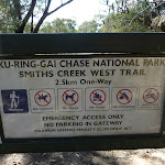
Turn left : From the intersection[33], this walk follows a level management trail north[34], passing a locked gate with ‘Ku-Ring-Chase National Park, Smith Creek West Trail, 2.5km One-Way’ sign on it[35]. The walk continues along this trail, with views to the left after about 800m[36]. This walk follows the trail gently downhill, steepening[37] after about 600m through switchbacks[38] to Smith Creek[39].

Maps for the The Perimeter Trail to Smiths Creek walk
You can download the PDF for this walk to print a map.
These maps below cover the walk and the wider area around the walk, they are worth carrying for safety reasons.
| Hornsby | 1:25 000 Map Series | 91304S HORNSBY | NSW-91304S |
| Ku-ring-gai Chase National Park Tourist Map | 1:40 000 Map Series | CMA Ku-ring-gai Chase National Park Tourist Map | CMA Ku-ring-gai Chase National Park Tourist Map |
| Sydney | 1:100 000 Map Series | 9130 SYDNEY | 9130 |
Cross sectional view of the The Perimeter Trail to Smiths Creek bushwalking track
Analysis and summary of the altitude variation on the The Perimeter Trail to Smiths Creek
Overview of this walks grade – based on the AS 2156.1 – 2001
Under this standard, a walk is graded based on the most difficult section of the walk.
| Length | 16.1 km | ||
| Time | 6 hrs | ||
| . | |||
| Grade 3/6 Moderate track |
AS 2156.1 | Gradient | Short steep hills (3/6) |
| Quality of track | Clear and well formed track or trail (2/6) | ||
| Signs | Directional signs along the way (3/6) | ||
| Experience Required | Some bushwalking experience recommended (3/6) | ||
| Weather | Weather generally has little impact on safety (1/6) | ||
| Infrastructure | Generally useful facilities (such as fenced cliffs and seats) (1/6) |
Some more details of this walks Grading
Here is a bit more details explaining grading looking at sections of the walk
Gradient
Around 5km of this walk has short steep hills, whilst the remaining 2.7km has gentle hills with occasional steps.
Quality of track
Around 8km of this walk follows a clear and well formed track or trail, whilst the remaining 140m follows a smooth and hardened path.
Signs
Around 6km of this walk is clearly signposted, whilst the remaining 2.3km has directional signs at most intersection.
Experience Required
Around 4.9km of this walk requires some bushwalking experience, whilst the remaining 3.2km requires no previous bushwalking experience.
weather
This whole walk, 8km is not usually affected by severe weather events (that would unexpectedly impact safety and navigation).
Infrastructure
This whole walk, 8km is close to useful facilities (such as fenced cliffs and seats).
Similar walks
A list of walks that share part of the track with the The Perimeter Trail to Smiths Creek walk.
5.2 km Return
1 hr 45 mins
Moderate track
5.3 km Return
2 hrs 30 mins
Moderate track
5.5 km Return
2 hrs
Moderate track
7.2 km One way
2 hrs 45 mins
Moderate track
Other Nearby walks
A list of walks that start near the The Perimeter Trail to Smiths Creek walk.
2.5 km Return
1 hr 30 mins
Moderate track
552 m Return
15 mins
Very easy
1.6 km Return
40 mins
Moderate track
4.4 km Return
2 hrs
Moderate track
1.1 km Return
1 Hr
Hard track
5.3 km One way
2 hrs 30 mins
Hard track
798 m Circuit
30 mins
Very easy
5.2 km Circuit
2 hrs 15 mins
Hard track
6.7 km Return
2 hrs 30 mins
Moderate track
3.9 km Circuit
2 hrs
Hard track

2.4 km Return
1 Hr
Hard track
Plan your trip to and from the walk here
The The Perimeter Trail to Smiths Creek walk starts and ends at the Int of Cullamine Rd & Bulara St (gps: -33.664104, 151.18876)
Your main transport option to Int of Cullamine Rd & Bulara St is by;
![]() Car. There is free parking available.
Car. There is free parking available.
(get details)
Short URL = http://wild.tl/pttsc
Gallery images
There are other downloads I am still working on.
You will probably need to login to access these — still all free.
* KML (google earth file)
* GPX (GPS file)
Special Maps/ brochures
* A3 topo maps
* PDF with Lands Topo map base
* PDF with arial image (and map overlay)
I wanted to get the main site live first, this extra stuff will come in time.
Happy walking
Matt 🙂
Cowan to Wondabyne station via Patonga rest area

2 Days
33.4 km One way
1523 m
Hard track
This section of the Great North Walk starts from Cowan train station and wanders past the majestic Jerusalem Bay then through to Brooklyn. After a ferry ride to Patonga, this walk climbs to the top of the ridge, reaching even more great views. Day 2, the track heads over the scenic Mt Wondabyne and around to Wondabyne Station. Please check timetables for ferry and trains as they can be infrequent.


(0km) Cowan Station → Freeway Bridge
300 m
6 mins
8m
-15m
Easy track
From the front of Cowan station[1], this walk follows the GNW arrow[2] up the concrete ramp, turning right to cross the track at the controlled ‘Pedestrian Railway Crossing’[3][4]. The walk follows the ramp onto platform 1 (Sydney-bound side) then around the shelter[5] to follow the GNW arrow post right, down the steps[6] and through the gate.
Here the walk crosses the train lines (train storage area) and turns left, following the ‘Brooklyn’ sign[7] along the wide management trail[8]. After 130m, the trail leads past an electrical switching area[9] then turns right at the large ‘Great North Walk’ signposts[10]. Here, the narrower trail leads between the fences over a small rise[11] to cross the freeway on a large, fenced concrete bridge[12].
Here the walk crosses the train lines (train storage area) and turns left, following the ‘Brooklyn’ sign[7] along the wide management trail[8]. After 130m, the trail leads past an electrical switching area[9] then turns right at the large ‘Great North Walk’ signposts[10]. Here, the narrower trail leads between the fences over a small rise[11] to cross the freeway on a large, fenced concrete bridge[12].
(0.3km) Freeway Bridge → Jerusalem Bay
2.2 km
50 mins
61m
-222m
Moderate track
Continue straight: From the overpass, this walk heads away from the freeway and down the wide track[13]. The track leads down a series of timber steps[14][15], then over a small rise (among the scribbly gums[16]) where the track begins to narrow and lead more steeply down a rocky section[17]. The walk then heads down a series of timber steps[18] (passing a ‘Great North Walk’ sign[19]), and crosses a short section of timber boardwalk[20]. At the other end of the boardwalk, this track leads left over a rock platform[21] (with a small creek flowing after rain) and then turns right to step off the rock platform[22].
Continue straight: From the intersection, this walk heads downhill along the rocky track[23][24]. The track leads past a few rock walls[25] over about 350m, then turns right onto, then steps down off, a long thin rock platform[26]. The track continues down along the side of the valley for another 200m, passing into a much more lush and dense forest[27], where the track then crosses the creek at a large rock platform[28].
On the other side of the creek, the track leads right down along the other side of the valley[29], passing a few small sandstone overhangs[30][31] then a particularly broad angophora tree[32] after about 500m. Soon after this angophora, the track leads down some rock steps[34] then begins to widen for about 300m, and passes a small track (on your right) marked with a ‘No Camping or fires allowed’ sign[35]. By this point, the broad waters (or mud flats, depending on the tide) of Cowan Creek are obvious[36], on your right. The walk now continues along the generally broad and flat track[37] for another 500m, then climbs up a set of concrete steps[38], marked with a GNW arrow post. At the top of these steps is a large, fairly flat clearing[39] with a ‘No Camping’ and a ‘Great North Walk’ sign[40] and a great view up the middle of Jerusalem Bay[41].
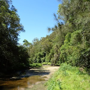
Jerusalem Bay
Jerusalem Bay, Ku-ring-gai National Park, is a nice bay east of Cowan Station. The bay is popular with bushwalkers as it is part of the Great North Walk. The bay is sometimes known for an iconic photo of the single palm in front of the water. The bay itself is also popular with boaters who can anchor in the bay. Jerusalem Bay can be accessed by the Hawkesbury River and Broken Bay or from Brooklyn or Cowan Railway Stations.
(2.46km) Jerusalem Bay → Int. Jerusalem Bay Trk and Brooklyn Dam Service Trail
3 km
1 hr 29 mins
350m
-183m
Hard track
Continue straight: From the clearing at Jerusalem Bay, this walk follows the ‘Great North Walk’ sign[42], keeping the water to your right. The track bends left then leads down some sandstone steps[43] (with a handrail). The track soon becomes fairly rough and follows the shoreline[44] for about 200m before crossing a rocky and mossy gully[45]. On the other side of this gully, the track tends right, following the GNW arrow post[46] past a sandstone overhang[47], and over a small flat timber bridge[48]. Just past this bridge, the track bends left and starts to climb steeply[49] up the particularly rocky track[50]. After about 300m of climbing, the track passes a small clearing with a small seat[51] (on your right). Over the next 400m, the rocky track still heads up, but is generally less steep[52][53]. The walk then comes to a large rock outcrop[54], where the track turns right to head up through a rocky gully[55]. About 60m after this climb, the track leads up another short climb[56] to a rock platform[57], then a third consecutive climb[58] leads up through a crack in a rock[59] to find a much welcomed bench seat[60] and ‘Great North Walk – Track Register’ log book box[61][62]. From here, the walk follows the the track gently uphill for another 60m to a ‘Jerusalem Bay’ sign[63] pointing back along the track, at the top of the ridge.
Continue straight: From the top of the ridge, this walk follows the ‘Brooklyn Dam’ sign[64], gently uphill, heading north through the tall heath. The mostly flat track leads through the forest[65], with an occasional glimpse[66][67] to the freeway and down to Brooklyn. after about 400m, the track bends left and leads through a long cleft in the rock[68]. Here the track start to head more and more steeply down[69] for the next 350m, until heading down some timber steps[70] which lead to Campbells Creek. The walk steps over the small (orange, polluted [71]) creek to find a flat sandy clearing [72] a few metres past the creek.
Continue straight: From the small clearing[73], this walk follows the clear track away from the creek, and soon bends left then begins to climb. The rocky track climbs steeply for about 200m, passing among the grass trees and eucalyptus[74]. The track flattens out and passes alongside a rock wall[75], then resumes the climb up the hill. At the top of this climb, the track passes a couple of small rock overhangs[76] then climbs about halfway up a section of rock[77] to follow the longer section of rock platform[78] to the right. The track then gently undulates along the side of the hill, passing a section of hand rail[79] after about 70m. The track then follows a series of small rock walls[80] (on your left) for about 250m before climbing up onto a flat, sandy track. This soon leads to a faint intersection[81] (with a track on your right, which goes to a large rock platform[82]). From here, the sandy track stays mostly flat[83] for about 300m before veering left at a GNW arrow post, leading up a more rocky section of track[84] and then climbing up some steel pegs[85] in the rock wall at the next GNW arrow post[86]. Here the track leads up the short hill and comes to a T-intersection with a wide management trail, where a ‘Jerusalem Bay’ sign[87] points back down the hill.
(5.49km) Int. Jerusalem Bay Trk and Brooklyn Dam Service Trail → freeway view point
100 m
2 mins
3m
-11m
Hard track
Turn left : From the intersection, this walk heads in the opposite direction to the ‘Brooklyn’ arrow[88], uphill along the wide management trail, keeping the power lines to your left. The trail leads through the tall heath and soon heads more steeply up[89] a short hill to a concrete section of old road[90]. The concrete section leads to the unfenced view point at the top of a large cutting, overlooking the freeway[91]. At the end of this side trip, retrace your steps back to the main walk then Continue straight.
(5.49km) Int. Jerusalem Bay Trk and Brooklyn Dam Service Trail → Upper Int. of Brooklyn Dam Service Track and Brooklyn Dam Bushtrack
2.8 km
57 mins
86m
-133m
Moderate track
Turn right: From the intersection, this walk follows the ‘Brooklyn’ sign[92] down along the wide management trail, initially keeping the power lines to your right[93]. The trail gently undulates along the top of the ridge for about 700m, passing a few short side tracks[94][95] (which lead to the power poles) and distant valley glimpses. The trail leads over a solid rock platform[96] and less than 100m later, the walk leads past a track[97] (on your right, which leads to a unfenced view over the valleys[98], from the power pole). The walk continues along the main trail for another 90m then follows a GNW arrow post[99] as the trail bends left[100], then right, to head downhill notably steeply for a short time[101]. The trail then continues to undulate along the top of the ridge for about 1.2km, passing more side tracks to power poles[102][103] (some with unfenced views). The walk then comes to a point where the trail bends sharply right[104], and there is a filtered view over the Hawkesbury River to Peats Ferry Bridge[105].
From here, the walk heads quiet steeply down[106] for about 400m to pass under some power lines[107], where the trail then bends sharply left[108] (enjoying some filtered views down to Brooklyn Dam[109] and the Hawkesbury[110], on your right), passing under then same power lines again. The trail soon flattens out, coming to a faint three-way intersection[111] (with a re-vegetating track on your right), marked with a ‘Great North Walk’ sign[112].
From here, the walk heads quiet steeply down[106] for about 400m to pass under some power lines[107], where the trail then bends sharply left[108] (enjoying some filtered views down to Brooklyn Dam[109] and the Hawkesbury[110], on your right), passing under then same power lines again. The trail soon flattens out, coming to a faint three-way intersection[111] (with a re-vegetating track on your right), marked with a ‘Great North Walk’ sign[112].
(8.28km) Upper Int. of Brooklyn Dam Service Track and Brooklyn Dam Bushtrack → NW Brooklyn Dam Campsite
1.3 km
28 mins
31m
-95m
Moderate track
Continue straight: From the intersection, this walk follows the ‘Great North Walk’ sign[113] along the wide management trail as it initially leads over a small rise[114] then heads downhill, keeping the valley to your right. After about 300m, the trail turns sharp right at the T-intersection with another wide trail[115]. This flat wide trail[116] follows the power lines for about 250m to then veer left (at the Y-intersection[117]), heading downhill away from the power lines. The trail leads downhill for just shy of 300m, passing the speed hump signs[118] to then bend right at the large clearing[119] (ignoring the fenced trail[120] on your left). Then about 100m later, this walk ignores another fenced trail[121] (on your left) as this trail is still bending right. Here the trail heads around the side of the hill for 400m to come to an intersection with a track[122] (on your left, leading a few meters to the signposted campsite[123]) marked with a GNW arrow post[124].
Small Campsite Brooklyn Dam
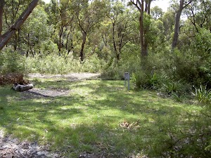
The small campsite next to Brooklyn Dam, Ku-ring-gai Chase National Park, is a small grassy campsite which has room for approximately four sites. The close proximity to Brooklyn Dam means close water. The campsite also has a few tall shady trees and is a fuel-stove only site.
(9.63km) NW Brooklyn Dam Campsite → NE Brooklyn Dam Campsite
180 m
4 mins
7m
-7m
Hard track
Turn left: From this intersection, this walk follows the track[125] east, away from the main trail and through the small ‘Brooklyn Dam’ campsite[126]. On the other side of the campsite, the narrow track bends right and leads down into the gully[127], down a few concrete steps[128] then heading alongside the small creek. Just before the dam wall, the track bends left, across the creek[129] and up the short rocky hill[130] to find a larger clearing[131]. There is a good view over the dam[132] (on your right). The track continues bending right through the clearing, and up a short hill to an intersection with the wide trail[133]. Now Turn left to rejoin the main walk .
(9.63km) NW Brooklyn Dam Campsite intersection → Lower Int. of Brooklyn Dam Service Track and Brooklyn Dam Bushtrack
90 m
2 mins
1m
-1m
Easy track
Continue straight: From the intersection, this walk follows the GNW arrows post[134] south along the wide trail, soon passing alongside the dam[135] (on your left). About 40m after passing edge of the dam wall, this walk comes to an intersection with a re-vegetating track[136] (on your right) and a large ‘Ku-ring-gai Chase National Park – Brooklyn Dam’ sign[137] (on your left).
(9.72km) Lower Int. of Brooklyn Dam Service Track and Brooklyn Dam Bushtrack → NE Brooklyn Dam Campsite
700 m
13 mins
14m
-14m
Easy track
Continue straight: From the intersection, this walk follows the GNW arrow post along the wide trail, keeping the dam to your left. (This section of trail leads around to the far side of the dam.) After just over 250m, the trail crosses a small creek (at the apex of the dam) then continues bending left. The track passes some old concrete pipes[138] (on your left) then after about 400m, the trail comes to an intersection with a clearing and dam wall (to your left).
Large Campsite Brooklyn Dam
The large campsite next to Brooklyn Dam, Ku-ring-gai Chase National Park, is a spacious and well-maintained campsite which has room for plenty of tents. The close proximity to the dam means accessible water (treat before drinking). The campsite has many tall, shady trees and is a fuel stove only site. The concrete dam wall was built in 1884 to provide water for the steam trains passing about 500m to the north. The dam was enlarged six times before 1924, then in in 1989 the dam was added to the expanded Ku-ring-gai Chase National Park.
(10.42km) NE Brooklyn Dam Campsite → Int of George & William Sts
2.7 km
59 mins
100m
-165m
Hard track
Veer right: From the intersection, this walk follows the GNW arrow post uphill along the management trail[139], directly away from the dam. After about 30m, the trail bends right and passes a ‘Ku-ring-gai Chase National Park – Brooklyn Dam’ sign[140] and continues uphill for another 150m, to where the trail becomes less steep (enjoying some filter views over the Hawkesbury[141] on your left) for about 180m. Here a GNW arrow post[142] guides along a short track (on the left), that runs parallel[143] before re-joining the main trail again a short distance later. The walk then continues uphill to veer right at a three-way intersection[144], under the power lines, then about 120m later, this walk veers right[145] again at another three-way intersection. About 70m up from here, the walk veers left[146] at another three-way intersection, this time the trail generally follows the power lines[147] along the side of the ridge. After another 300m, the trail bends right and passes under a set of high tension power lines[148], then continues to gently undulate for another 600m to come to a three-way intersection (with a clearing and trail[149] on your left) and a ‘Cowan’ sign[150] pointing back along the trail.
Continue straight: From the intersection, this walk follows the ‘Brooklyn Station’ sign[151] gently downhill along the management trail, keeping the Hawkesbury River glimpses to your left. The trail gently undulates[152] for about 600m before bending left to find a large clearing[153] and water glimpses. From the clearing, the trail starts to lead downhill[154] towards the water, and after nearly 100m, the trail leads steeply down a short section of concreted trail[155]. Just after this, the trail leads steeply again over a longer section of concrete[156], where the trail then leads through a rock cutting[157] to find an even longer and steeper section of concrete trail[158]. This section of concrete leads down for about 220m, sweeping left to head around a locked gate[159], past a large ‘Great North Walk’ sign[160] to find the southern end of William St. Here the walk turns right to head down William St[161] then across George St[162] to find a few ‘Great North Walk’ signs on the corner[163].
Continue straight: From the intersection, this walk follows the ‘Brooklyn Station’ sign[151] gently downhill along the management trail, keeping the Hawkesbury River glimpses to your left. The trail gently undulates[152] for about 600m before bending left to find a large clearing[153] and water glimpses. From the clearing, the trail starts to lead downhill[154] towards the water, and after nearly 100m, the trail leads steeply down a short section of concreted trail[155]. Just after this, the trail leads steeply again over a longer section of concrete[156], where the trail then leads through a rock cutting[157] to find an even longer and steeper section of concrete trail[158]. This section of concrete leads down for about 220m, sweeping left to head around a locked gate[159], past a large ‘Great North Walk’ sign[160] to find the southern end of William St. Here the walk turns right to head down William St[161] then across George St[162] to find a few ‘Great North Walk’ signs on the corner[163].
(13.1km) Int of George & William Sts → Int of Brooklyn & Dangar Rds
200 m
4 mins
2m
-5m
Very easy
Turn left: From the intersection, this walk follows the ‘Great North Walk – Direct Route’ sign[164] gently uphill along the footpath beside George St. At the top of this hill, the walk turns right onto ‘Bridge St’[165] and heads down past a cafe, post office[166] and ‘The Anglers Rest’[167] (on the other side of the road) and crosses ‘Brooklyn Rd’ to find a phone box[168] on the other side.
Brooklyn Accomodation
Brooklyn is a lovely little village with plenty of holiday style accommodation. There are several small cafe/restaurants in the area, good choice for cooked meals. There are two options for overnight visits, both need to be booked in advance.
Brooklyn Motel: Newly renovated accommodation on Bridge St,nearly opposite The Anglers Rest. This studio style accommodation starts from $120 per night with a spa, television and free wifi. Ph: 99858540 or 0410454530. Breakfast can be organised for an extra fee.
The Anglers Rest: Pub style accommodation on the intersection of Brooklyn & Dangar Rds. There are shared bathroom facilities. From $60 single and $90 a double. Breakfast not included (but you can grab breakfast from a cafe) PH:(02)9985-7257
(13.3km) Int of Brooklyn AND Dangar Rds → Hawkesbury River Railway Station
90 m
1 mins
1m
0m
Very easy
Continue straight: From the intersection, this walk follows the footpath down along Dangar Road past the phone box[169], keeping the train line and road to your left. The path soon leads past the community centre[170] then the blue painted ‘JJs Brooklyn’ fish and chip store[171] to come to the sandstone ‘Obelisk’ commemorating the naming of the Hawkesbury River[172]. This is just on the other side of the road, opposite some large ‘Great North Walk’ signs and the Hawkesbury River Railway Station[173].
(13.39km) Brooklyn Railway Station → Brooklyn Ferry Terminal
100 m
2 mins
0m
-3m
Easy track
Continue straight: From the street-side of Brooklyn Railway Station, this walk heads north-east along the footpath, towards the water, for approximately 50m, coming to the ferry terminal on the other side of the car park.
(13.49km) Brooklyn Ferry Terminal → Patonga Wharf car park
8.4 km
1 Hr
3m
-2m
Easy track
Continue straight: From the wharf near Hawkesbury River (Brooklyn) Station, the walk becomes a ferry ride. This service needs to be booked ahead of time (only runs when there are enough people). The ferry usually runs once a day (except Fridays) at 1:30 pm from Brooklyn, arriving at Patonga Beach at 2:20pm. On weekends, there is an extra service at 11:00 am from Brooklyn, arriving at Patonga Beach at 11:45am. Times are affected by weather. Phone: (02) 9985 7566. Alternatively, you can catch a water taxi – they generally cost about $100 per group of 4 and need to be booked ahead. There are a few options – try Hawkesbury River Water Taxi on 0400 600 111 or Rick on 0448 101 010. More info.
Patonga Village
Patonga Village is a lovely small township on the Hawkesbury River. Just near the ferry wharf are a few helpful facilities:
The Eve Williams Memorial Oval[174], where you will find a large pavilion[175], drinking water[176] and public toilets[177].
A fish and chips shop (and general store)[178] is open reasonable hours, where you can buy lunch, a coffee[179] and basic supplies (fishing needs, milk, canned food)[180].
Patonga Beach Hotel[181] is available for a cold drink at the bar[182] or a meal on the deck[183], or even overnight accommodation[184] (from $242 a couple) ph: 02 4379 1111.
(21.84km) Patonga Wharf car park → Eastern end of Patonga Beach
530 m
10 mins
14m
-13m
Easy track
Veer right: From the car park[185] at Patonga wharf[186], this walk follows the footpath beside Patonga Drive[187], keeping the water on the right. The road leads out of town passing beside ‘Eve Williams Memorial Oval’[188][189][190] for 70m to find a large ‘The Great North Walk’ sign[191] opposite the toilet block[192]. Soon after this sign, this walk turns right following the ‘Boat Ramp’ sign and GNW arrow post[193] down along a side road[194] for 220m to find a parking area beside Patonga’s boat ramp[195]. (Alternatively it is possible to walk along the sandy beach[196] from the wharf to the boat ramp.)
Continue straight: From the boat ramp, this walk follows the power lines across the car park, keeping the water to the right. The walk heads around the gate and continues to follow the power lines across the sand, coming to the eastern end of Patonga Beach and the ‘Brisbane Water National Park’ sign[197]. This area of the beach is also know as ‘Dark Corner’.
Continue straight: From the boat ramp, this walk follows the power lines across the car park, keeping the water to the right. The walk heads around the gate and continues to follow the power lines across the sand, coming to the eastern end of Patonga Beach and the ‘Brisbane Water National Park’ sign[197]. This area of the beach is also know as ‘Dark Corner’.
(22.37km) Eastern end of Patonga Beach → Broken Bay View
590 m
21 mins
122m
0m
Moderate track
Continue straight: From the eastern end of Patonga beach, this walk follows the ‘Warrah Trig 1.7km’ sign[199] up the steps. The track winds up the side on the hill, turning left and following the ridge line uphill. Soon after passing up some stairs between the rock, the track comes to a lovely view across the water. Here, the track turns left and climbs up more steps before flattening out and passing a few more GNW arrows. Just after passing two GNW arrows next to each other (at the end of a large crack in the rock), the track passes a few large Sydney Red Gums and comes to an unfenced rock platform on the right – Broken Bay view.
Broken Bay View

Broken Bay View is an informal, unnamed and unfenced vantage point at the top of the cliffs, east of Patonga. The large rock platform has a number of large Sydney Red Gums, providing some shade. There are great views across the Hawkesbury River, along Cowan Creek and to West Head. The views to the left extend past Lion Island to Barrenjoey Head and out to the Pacific Ocean.
(22.96km) Broken Bay View → Warrah Lookout intersection
700 m
15 mins
26m
-26m
Moderate track
Veer left: From the Broken Bay view, this walk follows Great North Walk arrows uphill along the track. The track winds gently through the bush, with the occasional water glimpse to the right. After a short time, the track comes to a clear intersection with the Pearl Beach / Patonga fire trail with a sign pointing back to ‘Patonga’[200].
Veer right: From the intersection, this walk follows the Great North Walk arrow downhill along the wide management trail. After about 250m, the trail passes a track on the right (marked with 5 large boulders – this informal track leads to an unfenced view). The walk continues along the management trail for another 100m and comes to an intersection near the Warrah Lookout, and a sign pointing back to ‘Patonga’[201].
Veer right: From the intersection, this walk follows the Great North Walk arrow downhill along the wide management trail. After about 250m, the trail passes a track on the right (marked with 5 large boulders – this informal track leads to an unfenced view). The walk continues along the management trail for another 100m and comes to an intersection near the Warrah Lookout, and a sign pointing back to ‘Patonga’[201].
(23.66km) Warrah Lookout intersection → Warrah Lookout
70 m
2 mins
0m
-12m
Easy track
Turn right: From the intersection, this walk heads between the timber posts and follows the ‘Warrah Lookout’ sign[202] along the sandstone footpath. The path leads through the bush for a short distance, coming to the fenced Warrah Lookout. (Beware of informal side tracks that lead to unfenced sections of cliff.) At the end of this side trip, retrace your steps back to the main walk then Continue straight.
Warrah Lookout
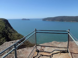
Warrah Lookout is a mostly fenced lookout on a large sandstone platform. The lookout provides fantastic views across the Hawkesbury River. From left to right, you can see along the escarpment which forms the southern boundary of Brisbane Water National Park, out to the Pacific Ocean, Barrenjoey Headland, West Head, along Cowan Creek, Juno Point and along the escarpment to Patonga. This is a great place to spend some time soaking up the views.
(23.66km) Warrah Lookout intersection → Warrah Trig Station
310 m
7 mins
39m
0m
Easy track
Turn left : From the intersection, this walk follows the ‘Tony Doyle Track, Warrah Car Park’ sign[203] up the sandstone steps and footpath. After winding through and over some rock platforms, the path leads up the hill to two sets of timber staircases. At the top of the second set, the walk comes to the old Warrah Trig station (a green metal post).
Warrah Trig Station
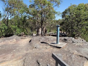
Warrah Trig Station is part of a national geodetic survey established during the 1970’s. The ‘Triangulation station’ (aka trigonometrical or trig station) is a distinct marker once clear of trees, and would have been visible for many kilometers in the area. There are many such trig stations around Australia, which were used to help in surveying. Each station has a know position and altitude, which allows surveyors to use triangulation and determine another point’s location. With advances in technology, these trig stations have been abandoned and superseded. The trig station is now surrounded by trees, with some filtered views along the Hawkesbury River[204]. The area is rich with wildflowers in spring.
(23.97km) Warrah Trig Station → Warrah car park
30 m
1 mins
0m
0m
Easy track
Continue straight: From Warrah Trig Station, this walk follows the sandstone steps and footpath down the hill towards the dirt road. The path soon passes a plaque and a sign pointing back along the ‘Tony Doyle Track’[205] and comes to the Warrah car park.
(24km) Warrah Car Park → Int Warrah Trig Rd trail and Warrah Trig Station Rd
310 m
5 mins
2m
-4m
Easy track
Continue straight: From Warrah car park, this walk follows the road off the sealed section and along the dirt. The road passes a larger dirt overflow car park, then ignores an old trail (on the right) to soon come to an intersection with a management trail and gate on the left side.
(24.31km) Int of Warrah Trig trail and Warrah Trig Station Rd → Int of Great North Walk and Patonga Dr
1.2 km
22 mins
23m
-14m
Moderate track
Continue straight: From the intersection, this walk follows the dirt road north up a long and gentle hill. The road leads to an intersection with a track on the right marked with a Great North Walk arrow about 30m before Patonga Drive.
Veer right: From the intersection, this walk follows the GNW arrow marker around the drainage ditch[206] to follow the track running parallel to Patonga Drive (keeping the road about 20m to your left). The track leads through the heath and scribbly gum forest[207] for about 100m before passing some distant ocean views[208] (on your right), where the track continues for another 150m to come to the sealed Patonga Drive[209]. Here the walk follows the GNW arrow post[210] across the road to a locked gate and management trail[211], marked with a ‘Great North Walk’ sign[212].
Veer right: From the intersection, this walk follows the GNW arrow marker around the drainage ditch[206] to follow the track running parallel to Patonga Drive (keeping the road about 20m to your left). The track leads through the heath and scribbly gum forest[207] for about 100m before passing some distant ocean views[208] (on your right), where the track continues for another 150m to come to the sealed Patonga Drive[209]. Here the walk follows the GNW arrow post[210] across the road to a locked gate and management trail[211], marked with a ‘Great North Walk’ sign[212].
(25.53km) Int of Great North Walk and Patonga Dr → Int of Rest Area and Girrakool tracks
120 m
2 mins
0m
-4m
Easy track
(25.65km) Int of Rest Area and Girrakool tracks → Rest Area
210 m
3 mins
1m
-7m
Moderate track
Patonga rest area
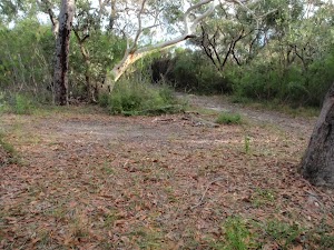
This small campsite is a signposted rest area, and is about 200m off the Great North Walk, just north of Patonga Drive. The campsite is a small, sandy clearing, with no facilities and no water, but it is sheltered by trees.
End of day 1
This is the planned overnight stay for the end of day 1, happy camping.
(25.85km) Rest Area → Rock platform intersection
950 m
15 mins
12m
-13m
Moderate track
Turn around: From the rest area, this walk heads east along the management trail for about 200m to come to a clear three-way intersection[221], where a ‘Rest Area’ sign[222] points back down along the trail.
Turn left: From the intersection, this walk follows the ‘Girrakool’ sign[223] gently up along the wide trail. After about 200m, the trail bends left[224], then leads gently down for another 100m, coming to an intersection[225] where the main trail bends right (and with the narrower Patonga Creek trail ahead), marked with a GNW arrow post[226].
Turn right: From the intersection, this walk follows the GNW arrow post north along the wide sandy management trail. The trail leads among the heath and large scribbly gums[227] for about 270m to come to T-intersection[228] with another wide trail[229], marked with a ‘Patonga’ sign[230] pointing back up along the trail.
Turn left: From the intersection, this walk follows the ‘Girrakool’ sign[231] downhill along the management trail. Over the next 200m, the trail gently bends right then comes to an intersection (just before a large open rock platform[232]), marked with a ‘Girrakool’ sign[233] (pointing right).
(26.81km) Int of Hawkesbury track and Patonga Dr trail → Int of Hawkesbury track and Sani Depot Trail
1.1 km
21 mins
25m
-39m
Moderate track
Turn right: From the intersection, this walk follows the ‘Girrakool’ sign[234] east uphill along the management trail[235]. The trail leads up the hill for about 25m to head over a short rock platform[236] where the trail continues fairly steeply uphill. The trail bends left[237] and then winds gently around the side of the hill[238], enjoying some views[239] along the way. The trail undulates for a while before leading gently down to pass a large clearing[240] (on your left). Just past this clearing, the trail heads down (fairly steeply at first) for about 200m to enter a tall wooded forest and come to a clear three-way intersection, marked with a ‘Sani Depot Trail’ sign[241] (on your right).
(27.92km) Int of Hawkesbury track and Sani Depot Trail → Rock Platform
1.3 km
25 mins
21m
-56m
Moderate track
Continue straight: From the intersection, this walk follows the GNW arrow post[242] downhill along the wide trail. The trail soon leaves the tall Sydney Redgums[243] to lead down for almost 600m. The walk crosses a culverted creek[244] (with sandstone blocks[245]) and then the trail mostly flattens out[246]. Here the trail continues for another 170m leaving the tall forest to walk through the open heath[247], passing near a small cliff (on your right), to come to an intersection with the faint track[248] (on your left, this is just before the main trail bends right and starts to lead downhill again).
Continue straight: From the intersection, this walk follows the wide trail downhill[249], keeping the valley to your left. The trail winds downhill for almost 600m, crossing a couple of culverted creeks[250][251], until, just after a left-hand bend, this walk comes to a noteable rock platform[252] (with an ephemeral creek) and filtered view down the valley (to your left)[253].
Continue straight: From the intersection, this walk follows the wide trail downhill[249], keeping the valley to your left. The trail winds downhill for almost 600m, crossing a couple of culverted creeks[250][251], until, just after a left-hand bend, this walk comes to a noteable rock platform[252] (with an ephemeral creek) and filtered view down the valley (to your left)[253].
(29.25km) Rock Platform → Int of Hawkesbury track near Patonga Creek
520 m
12 mins
24m
-27m
Moderate track
Continue straight: From the rock platform, this walk follows the trail north up the side of the hill. The trail leads uphill for about 25m before bending left and leading downhill[254] for about 80m, where the trail winds through a ferny valley[255] with a scattering of cabbage palms[256] (Livistona australis). Here the trail leads quite steeply uphill[257] for about 200m, then more gently downhill for just over 200m more, to come to a Y-intersection[258] with the signposted ‘Great North Walk’ track[259] (on your left). (The trail ahead soon leads over Patonga Creek[260] to the locked back[261] gate of Woy Woy Landfill).
(29.77km) Int of Hawkesbury track near Patonga Creek → Int of Hawkesbury Track and Dillons Trail
2.3 km
52 mins
128m
-86m
Hard track
Turn left: From the intersection, the walk follows the ‘Great North Walk’ sign[262] downhill along the track. After just shy of 100m, the track crosses Patonga Creek[263] among the moist cabbage palm[264] forest. Soon after crossing this creek, the track begins to head quite steeply uphill[265] for another 100m, passing a faint side track[266] before climbing up some carved steps[267] in the rock beside a sloped rock platform (on your left)[268]. The track continues steeply up for another 40m, where the track bends right (at the GNW arrow post)[269] to head over a mostly flat rock outcrop. The track continues (with occasional glimpses of the Woy Woy landfill[270]) gently uphill for just over 100m to pass another side track[271], then lead up a bit more steeply[272] for just over 100m more (past a rock wall[273], on your left) to come to an unfenced clear view over Woy Woy landfill[274] (where the track bends left[275]).
Veer left: From the view point over Woy Woy Landfill[276], this walk heads west following the rocky track uphill, directly away from the view. The sandy track[277] soon leads up a few rock steps[278] and after about 130m, climbs up a few carved steps[279] onto a fairly large rock platform[280], marked with a GNW arrow post[281]. The track now undulates, following a series of GNW arrow posts (generally up) along a rocky ridge line[282], passing over many rock platforms[283] for almost 1km (enjoying the distant views[284][285] over Woy Woy Bay and the Brisbane Water, to your right) to come to the highpoint on this section of track[286]. From here, the track continues mostly flat for the next 500m, then begins to head downhill for about 300m to come to a clear intersection[287] with the signposted ‘Dillons Trail’[288]. There is a sign pointing back up the track towards ‘Patonga’[289].
Veer left: From the view point over Woy Woy Landfill[276], this walk heads west following the rocky track uphill, directly away from the view. The sandy track[277] soon leads up a few rock steps[278] and after about 130m, climbs up a few carved steps[279] onto a fairly large rock platform[280], marked with a GNW arrow post[281]. The track now undulates, following a series of GNW arrow posts (generally up) along a rocky ridge line[282], passing over many rock platforms[283] for almost 1km (enjoying the distant views[284][285] over Woy Woy Bay and the Brisbane Water, to your right) to come to the highpoint on this section of track[286]. From here, the track continues mostly flat for the next 500m, then begins to head downhill for about 300m to come to a clear intersection[287] with the signposted ‘Dillons Trail’[288]. There is a sign pointing back up the track towards ‘Patonga’[289].
(32.05km) Int of Hawkesbury Track and Dillons Trail → Int of Tunnel Track and Mt Wondabyne trail
650 m
12 mins
23m
-9m
Moderate track
Continue straight: From the intersection, this walk follows the GNW arrow post west[290] (in the opposite direction to the ‘Patonga’ sign[291]. After about 20m, this short track leads to an intersection with the signposted ‘Tunnel Trail’[292].
Turn right: From the intersection, this walk follows the GNW arrow post[293] gently uphill along the ‘Tunnel Trail’. After about 50m, the trail passes through a metal gate[294] and fence then continues for just over 100m to come to the signposted intersection with the ‘Rocky Ponds Trail’[295], where a ‘Patonga’ sign[296] points back down along the trail.
Continue straight: From the intersection, this walk follows the GNW arrow marker and the ‘Girrakool’ sign[297] north, gently uphill along the wide trail. The trail winds along the side of the hill for just over 450m, to come to a small crest[298] and a clear three-way intersection with the signposted ‘Mt Wondabyne’ trail[299] (on the left).
(32.7km) Int of Tunnel Track and Mt Wondabyne trail → Mt Wondabyne Campsite
760 m
16 mins
49m
0m
Moderate track
Turn left: From the intersection, this walk follows the GNW arrow marker as well as the ‘Mt Wondabyne’[300] and ‘Girrakool’[301] signs uphill along the management trail. The trail winds up the hill for about 300m find a view of Mount Wondabyne[302] – there are also nice views behind (and to the right) across Woy Woy and the Brisbane Water[303]. The trail continues uphill for another 400m to end at a large clearing[304] (turning circle) at the base of a rock wall. This is the Mt Wondabyne Campsite[305] – there is also a sign pointing back down to ‘Patonga’[306].
Mt Wondabyne Campsite
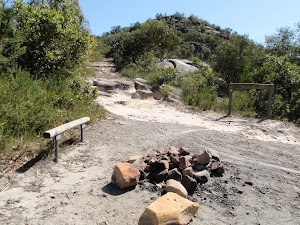
This basic campsite is found at the end of a management trail, near the base of Mt Wondabyne. The campsite is at the bottom of a small (east facing) rock wall and has trees surrounding much of the area, providing some shelter. There is an established fire circle and a basic seat. There is no water or other facilities. (There is also small cave suitable for sleeping a few people about half way up Mount Wondabyne).
(33.45km) Mt Wondabyne Campsite → Int of Great North Walk and Mt Wondabyne Peak tracks
90 m
2 mins
6m
0m
Moderate track
(33.54km) Int of Great North Walk and Mt Wondabyne Peak tracks → Mt Wondabyne Peak
210 m
5 mins
20m
-1m
Hard track
Turn right: From the intersection, this walk follows the Mt Wondabyne peak track north-east as it heads uphill directly towards Mt Wondabyne. The track is leads gently at first then starts to climb up a series of rock ledges[311]. After about 60m, the track passes a small cave[312] (large enough for 2 or 3 people to lie in). The track then continues to climb for another 90m, up the rocky track then for through a grove of small trees[313], to come to the first peak[314]. The faint track continues along the ridge for another 60m then comes to the main peak, where there is an old trig station[315] and great panoramic views[316]. At the end of this side trip, retrace your steps back to the main walk then Turn right.
Mt Wondabyne

Mount Wondabyne is one of the most prominent peaks in Brisbane Water National Park. The long cone-shaped hill has a rocky top and is home to a trig station. Walkers can enjoy full 360-degree panoramic views from the top. To the east are good views over the Brisbane Water, Woy Woy and other central coast suburbs. West, down next to Mullet Creek, you can see some buildings near Wondabyne Station and the train line. Otherwise, most of the expansive views are over much of Brisbane Water National Park. There are some small trees providing limited shade, a great place to soak up the views.
(33.54km) Int of GNW and Mt Wondabyne Peak tracks → Int of GNW and Mullet Creek Trail
950 m
21 mins
11m
-109m
Hard track
Continue straight: From the intersection, this walk follows the GNW arrow post north, gently down along the rocky track[317], keeping the Mt Wondabyne Peak up to your right. After about 50m, the track enters a forest of trees[318] and begins to head more distinctly downhill, passing a few large boulders[319] for about 700m, then coming to a GNW ‘Walker Register’ tube[320] on a post. After writing a comment, the walk continues down the track over a rock platform[321], and just past the rock platform[322] the sandy track leads downhill for about 200m as it widens significantly[323] and comes to a T-intersection[324] with another wide trail. There is a ‘Mt Wondabyne’ sign[325] here, pointing back up the hill.
(34.49km) Int of GNW and Mullet Creek Trail → Int of GNW and Mullet Creek Trail (east)
220 m
4 mins
4m
-14m
Easy track
Turn right: From the intersection, this walk follows the GNW arrow post and ‘Wondabyne Station’ sign[326] down a gentle hill as the trail bends right. The trail leads downhill and bends again to run parallel with the some power lines[327]. Then about 35 meters past the second power pole, this walk comes to an intersection with a track[328] (on your left), marked with a GNW arrow post.
(34.7km) Int of GNW and Mullet Creek Trail (east) → Int of GNW and Thommos Loop trail
830 m
18 mins
50m
-15m
Moderate track
Turn left: From the intersection, this walk follows the ‘Girrakool’ sign[329], heading under the power lines and down along the track to soon cross a small ephemeral creek[330]. From the creek, this walk follows a rock platform[331] for about 200m to then head over a section of timber boardwalk[332] and past a few disused power poles[333]. The track soon begins to climb and crosses a number or rock platforms[334] for about 300m to come to a notably large rock platform[335] with a wide view across the valley to Mt Wondabyne[336]. Here the track continues up for another 250m to an intersection[337] with a wide trail (at another rock platform), where a ‘Patonga’ sign[338] points back down along the track.
(35.53km) Int of GNW and Thommos Loop track → Int of the Great North Walk and Patonga service trail
1.5 km
28 mins
34m
-54m
Moderate track
Veer left: From the intersection, this walk follows the ‘Girrakool’ sign[339] across the rock platform, keeping the valley to your left. The walk enjoys views of Mt Wondabyne[340] (on the left) for about 130m to come to a particularly large rock platform[341]. Here the trail leads down[342] off this rock platform then winds along the side of the hill for about 1.3km (passing a pleasant grove of large Sydney Redgums[343]) to lead up to an intersection[344] (with a track on the left) where there is a sign pointing back to ‘Patonga’[345].
(37.02km) Int of the Great North Walk and Patonga service trail → Kariong Brook crossing
690 m
24 mins
21m
-122m
Hard track
Veer left: From the intersection, this walk follows the ‘Girrakool’ sign[346] gently down along the narrower track. The track leads down for about 60m to pass over a rock outcrop[347] and then 80m later, comes to a clearing that has been used as a campsite[348] (on your left). From the clearing, the track continues down the hill for about 150m, stepping down the rocks[349] and along a sandy track[350] to then bend right at metal handrail[351]. Here the rocky track becomes quite steep in places and winds down past some rock walls[352] and among the grass trees[353] for about 300m, where the track bends sharp right at the bottom of some steps in a cleft in the rock[354]. The track continues down for another 100m to follow the steps down through the sandstone overhang[355], here the track bends left then right to wind down and cross the creek (that is often underground) and come to an intersection with a faint track in front of Kariong Brook Falls[356] (on your right).
Kariong Brook Falls

This tranquil spot of the Great North Walk is home to some lovely falls and a water hole. The eastern side of the creek has a tall sandstone cave and wall. After rain these falls can become very spectacular, other times is a cool place to rest. A great spot to stop for a snack.
(37.71km) Kariong Brook crossing → Myron Brook crossing
400 m
11 mins
33m
-28m
Hard track
Continue straight: From the Kariong Brook, this walk follows the track north-west away from the cliffs (initially keeping the waterfall to your right). The track initially leads fairly steeply[357] out of the densely forested valley[358] then leads more gently uphill for about 100m to pass alongside a long rock wall[359] (on your right). From the end of the rock wall, the track starts to lead downhill[360] for about 200m, to then head down the embankment and steps[361] and cross Myron Brook on the sandstone rock platform[362], to the western bank.
(38.11km) Myron Brook crossing → Int of GNW and Wondabyne Station Trail
1.6 km
36 mins
178m
-36m
Hard track
Continue straight: From Myron Brook, this walk follows the rocky track west up the steep hill[363]l. After about 400m of steep climbing, the track mostly flattens out to head up through the cleft[364] in a rock and onto a flat rock platform[365]. Here the track continues more gently uphill, crossing more rock platforms for just over 1km, through the heath and scribbly gums[366], before bending left around a rocky outcrop[367] to come to a T-intersection[368] with a wide management trail. There is large sign here, pointing back down to ‘Patonga’[369].
(39.67km) Int of GNW and Wondabyne Station tracks → Eastern end of the Pindar Cave Track
630 m
11 mins
5m
-19m
Moderate track
Turn left: From the intersection, this walk follows the ‘Wondabyne Station’ sign[370] downhill along the management trail[371]. The trail gently undulates along the top of the ridge for about 600m to come to an intersection with the Pindar Cave track (leading over a rock platform[372], on your right), marked with a GNW arrow post[373] (on your left).
(40.3km) Eastern end of the Pindar Cave Track → Clearing above Wondabyne Station
1 km
19 mins
3m
-72m
Hard track
Continue straight: From the intersection[374], this walk follows the GNW arrow post south, gently down along the wide management trail. The trail soon bends right and leads quite steeply down[375] before mostly flattening out again[376]. From here, the trail leads gently downhill for about 600m until the trail bends left and leads quite steeply down[377] for just shy of 250m to come to a clearing at the end of this management trail[378], marked with a ‘Brisbane Water National Park’ sign[379].
(41.34km) Clearing above Wondabyne Station → Wondabyne Station
440 m
13 mins
15m
-100m
Hard track
Continue straight: From the clearing[380], this walk follows the GNW arrow post[381] south, down along the track to head down some carved steps through a cleft in a rock[382]. The track winds steeply down the series of rock steps[383] for about 150m to pass a filtered view (left) of the cranes[384], down at the old Gosford Quarry. The track continues to wind down, a little less steeply, for just over 200m to then climb down a timber staircase[385] (which starts with a metal landing at the top). From the bottom, the walk continues down towards the train line, soon bending left to pass a large boulder[386] and strangler fig tree[387] and come to the north-bound platform of Wondabyne Train Station[388].
Wondabyne
Wondabyne is situated in Brisbane Waters National Park on the banks of Mullet River, which feeds into the Hawkesbury River north of Brooklyn. The area is defined by the National Park’s flora and fauna, the quarry, railway station and a few houses sitting above the water around the river. The quarry produced sandstone building materials, used in the construction of the National War Memorial in Canberra. More recently, in 2000, the quarry was re-opened for restoration of St Mary’s Cathedral spire in Sydney. Wondabyne Station, named after the nearby Mt Wondabyne, was built in 1889 and exclusively used for the quarry – it was then known as Mullet Creek Station. The station is one of the smallest on the line and one of very few railway stations in a NSW National Park. When you catch the train to Wondabyne, let the guard know you want to get off at Wondabyne Station, otherwise the train will not stop. Travel in the last carriage as the platform is very short. To catch the train from Wondabyne, wave to the driver.
Maps for the Cowan to Wondabyne station via Patonga rest area walk
You can download the PDF for this walk to print a map.
These maps below cover the walk and the wider area around the walk, they are worth carrying for safety reasons.
| Gosford | 1:25 000 Map Series | 91312S GOSFORD | NSW-91312S |
| Cowan | 1:25 000 Map Series | 91304N COWAN | NSW-91304N |
| Broken Bay | 1:25 000 Map Series | 91301N BROKEN BAY | NSW-91301N |
| Ku-ring-gai Chase National Park Tourist Map | 1:40 000 Map Series | CMA Ku-ring-gai Chase National Park Tourist Map | CMA Ku-ring-gai Chase National Park Tourist Map |
| Gosford | 1:100 000 Map Series | 9131 GOSFORD | 9131 |
| Sydney | 1:100 000 Map Series | 9130 SYDNEY | 9130 |
Cross sectional view of the Cowan to Wondabyne station via Patonga rest area bushwalking track
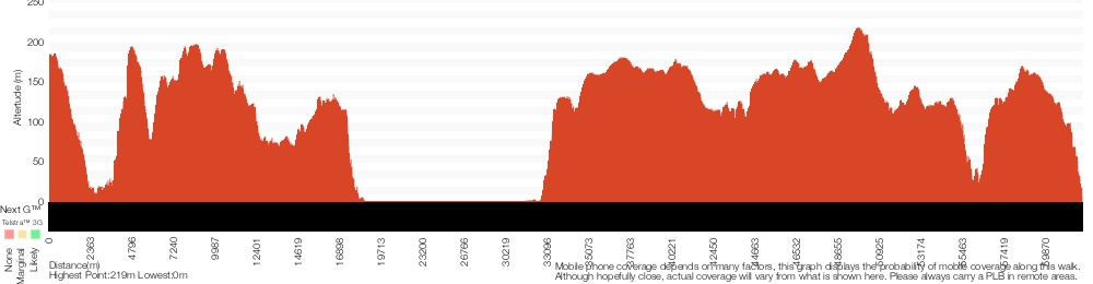
Analysis and summary of the altitude variation on the Cowan to Wondabyne station via Patonga rest area
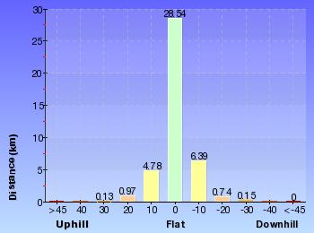
Daily actual walking time estimates
| Day | Walking Time | Length |
|---|---|---|
| 1 | 7 hrs 45 mins | 26.2 km |
| 2 | 5 hrs 45 mins | 16.1 km |
Overview of this walks grade – based on the AS 2156.1 – 2001
Under this standard, a walk is graded based on the most difficult section of the walk.
| Length | 33.4 km | ||
| Time | 2 Days | ||
| . | |||
| Grade 4/6 Hard track |
AS 2156.1 | Gradient | Very steep (4/6) |
| Quality of track | Rough track, where fallen trees and other obstacles are likely (4/6) | ||
| Signs | Minimal directional signs (4/6) | ||
| Experience Required | Some bushwalking experience recommended (3/6) | ||
| Weather | Storms may impact on navigation and safety (3/6) | ||
| Infrastructure | Limited facilities (such as cliffs not fenced, significant creeks not bridged) (4/6) |
Some more details of this walks Grading
Here is a bit more details explaining grading looking at sections of the walk
Gradient
13km of this walk has short steep hills and another 11km has gentle hills with occasional steps. Whilst another 10km is flat with no steps and the remaining 7km is very steep.
Quality of track
26km of this walk follows a clear and well formed track or trail and another 9km follows a rough track, where fallen trees and other obstacles are likely. Whilst another 7km follows a formed track, with some branches and other obstacles and the remaining 390m follows a smooth and hardened path.
Signs
25km of this walk has directional signs at most intersection and another 14km is clearly signposted. The remaining (2.2km) has minimal directional signs.
Experience Required
Around 27km of this walk requires no previous bushwalking experience, whilst the remaining 14km requires some bushwalking experience.
weather
Around 39km of this walk is not usually affected by severe weather events (that would unexpectedly impact safety and navigation), whilst the remaining 2.5km is affected by storms that may impact your navigation and safety.
Infrastructure
25km of this walk is close to useful facilities (such as fenced cliffs and seats) and another 16km has limited facilities (such as not all cliffs fenced). The remaining (1.2km) has limited facilities (such as cliffs not fenced, significant creeks not bridged).
Similar walks
A list of walks that share part of the track with the Cowan to Wondabyne station via Patonga rest area walk.
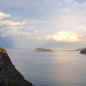
756 m Return
20 mins
Easy track
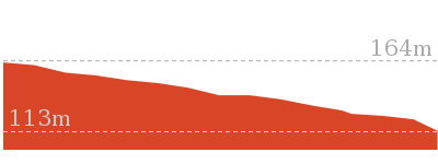
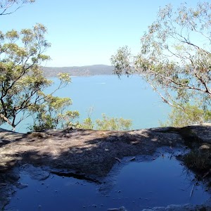
2.2 km One way
1 Hr
Moderate track
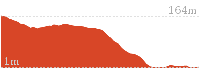
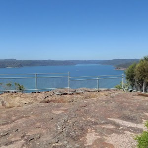
2.8 km One way
1 hr 15 mins
Moderate track
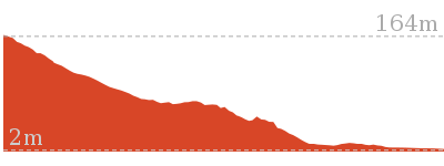
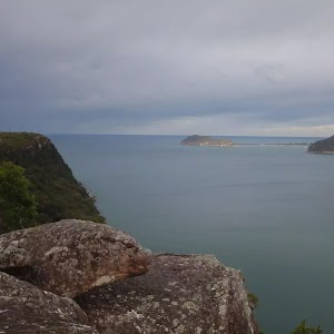
4.3 km Return
2 hrs
Moderate track
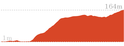
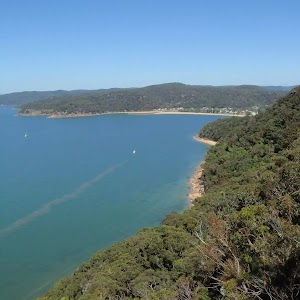
4.3 km One way
1 hr 45 mins
Moderate track
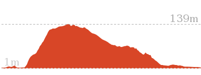
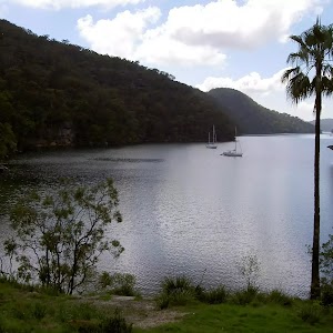
4.9 km Return
2 hrs
Moderate track
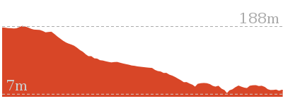
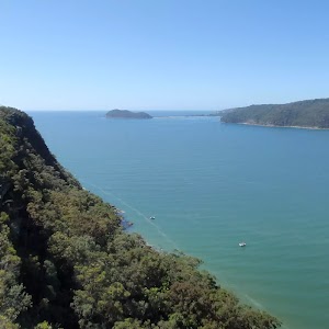
5.1 km Return
2 hrs
Moderate track
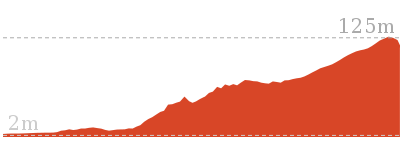
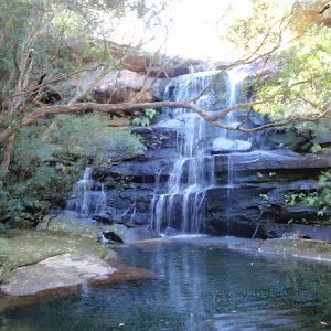
5.8 km Return
2 hrs 30 mins
Hard track
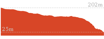
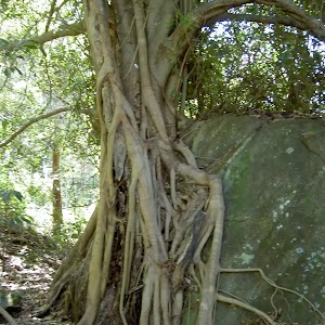
8.1 km Return
3 hrs 30 mins
Hard track
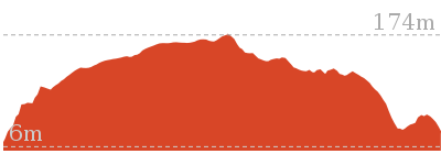
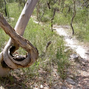
9.5 km One way
4 hrs
Hard track
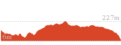
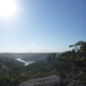
10.1 km One way
4 hrs 15 mins
Hard track
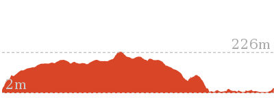
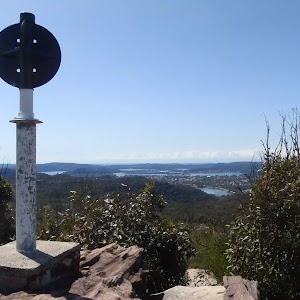
10.8 km Circuit
4 hrs 30 mins
Hard track
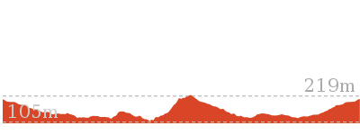
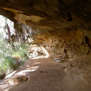
11.5 km Return
6 hrs
Experienced only
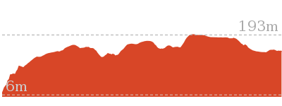
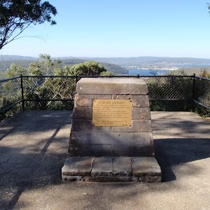
12.3 km One way
5 hrs 30 mins
Hard track
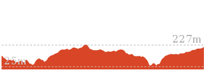
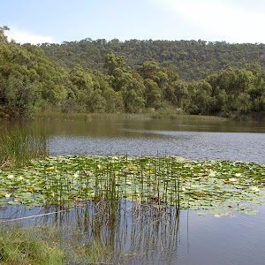
13.4 km One way
5 hrs 30 mins
Hard track
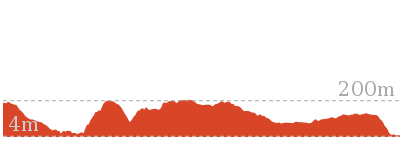
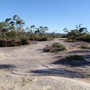
15.4 km One way
6 hrs
Hard track
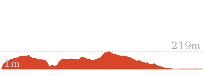
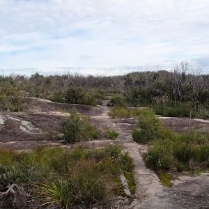
15.5 km One way
5 hrs 45 mins
Hard track
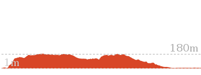
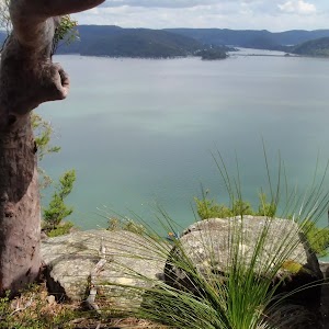
16.1 km One way
6 hrs 30 mins
Experienced only

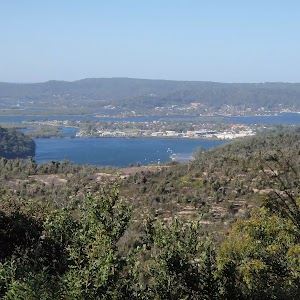
17 km One way
6 hrs 30 mins
Hard track
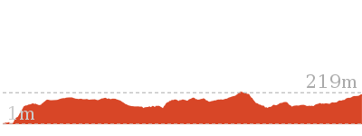
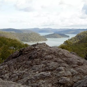
18.1 km One way
7 hrs 30 mins
Experienced only
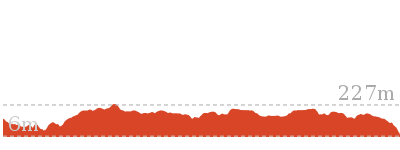
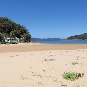
19.5 km One way
7 hrs 30 mins
Hard track
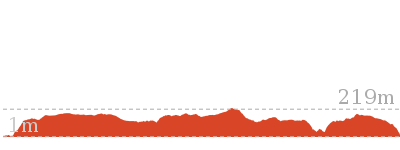
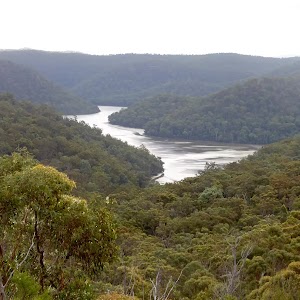
20.7 km One way
8 hrs 30 mins
Hard track
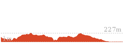
24 km One way
8 hrs 30 mins
Experienced only
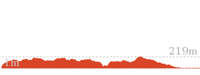
24.8 km One way
10 hrs
Hard track
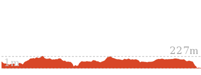
24.8 km One way
2 Days
Hard track

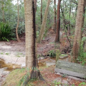
26.2 km One way
10 hrs
Hard track

26.2 km One way
2 Days
Hard track
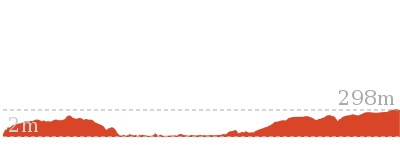
27.4 km One way
2 Days
Hard track
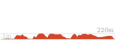
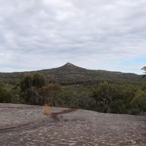
28.1 km One way
2 Days
Experienced only
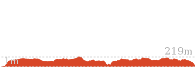
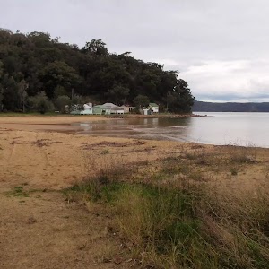
41.5 km One way
3 Days
Hard track
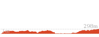
43.1 km One way
3 Days
Hard track
Other Nearby walks
A list of walks that start near the Cowan to Wondabyne station via Patonga rest area walk.
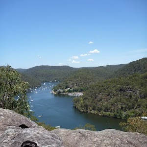
7.2 km One way
3 hrs 30 mins
Hard track
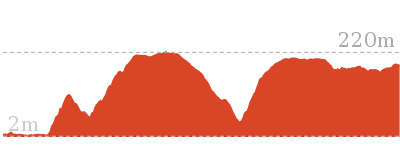
9.4 km One way
4 hrs 30 mins
Hard track
8.7 km One way
4 hrs
Hard track
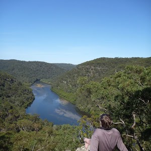
5.7 km One way
2 hrs 45 mins
Hard track
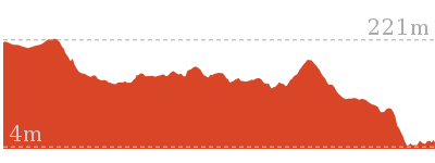
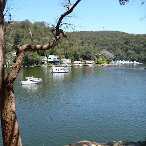
12.9 km One way
6 hrs
Hard track
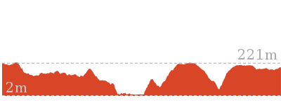
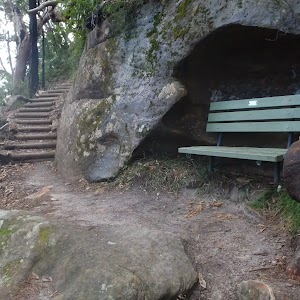
22.6 km One way
9 hrs 18 mins
Hard track
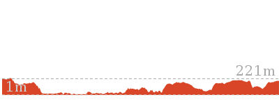
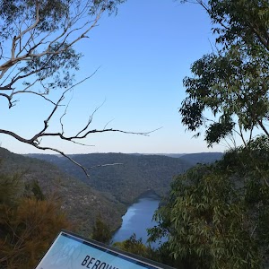
420 m Return
15 mins
Very easy
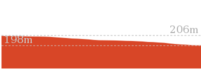
3 km Return
1 hr 15 mins
Moderate track
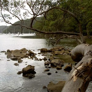
2.2 km Return
1 hr 15 mins
Hard track
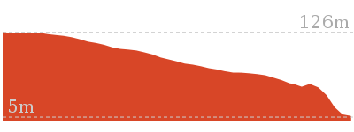
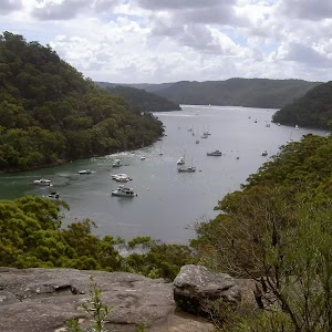
1.9 km Return
45 mins
Moderate track
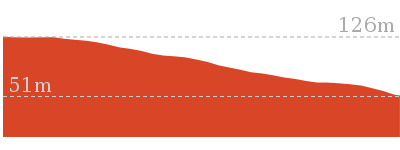
8.2 km Return
3 hrs
Hard track
5.9 km Circuit
3 hrs
Hard track
Plan your trip to and from the walk here
The Cowan to Wondabyne station via Patonga rest area walk starts at the Cowan Station (gps: -33.593766, 151.17169)
Your transport options to Cowan Station are by;
![]() Train. (get details)
Train. (get details)
![]() Bus. (get details)
Bus. (get details)
![]() Car. There is free parking available.
Car. There is free parking available.
(get details)
The Cowan to Wondabyne station via Patonga rest area ends at the Wondabyne Station (gps: -33.492083, 151.25696)
Your main transport option to Wondabyne Station is by;
![]() Train. (get details)
Train. (get details)
Important Note: There is no car transport option to the end of this walk.
Short URL = http://wild.tl/ctwsvvdbc
Gallery images
There are other downloads I am still working on.
You will probably need to login to access these — still all free.
* KML (google earth file)
* GPX (GPS file)
Special Maps/ brochures
* A3 topo maps
* PDF with Lands Topo map base
* PDF with arial image (and map overlay)
I wanted to get the main site live first, this extra stuff will come in time.
Happy walking
Matt 🙂
Fairfax Walk
And Walk
Fairfax Walk

30 mins
762 m Circuit
45 m
Very easy
This walk provides some of the best views in Sydney. This pleasant stroll and wheelchair-accessible walk starts from the car park at the end of the North Head Scenic Drive, and follows the asphalt footpath as it loops around the tip of North Head. Enjoy views of the entrance to Sydney Harbour, the coastal cliff line and a historic gun emplacement. The stunning lookouts provide great views all year round and a popular vantage point for whale watchers. The whales pass by twice annually, heading north in June and July, and again when they return to the Antarctic in August and October.

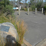
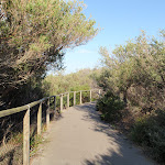
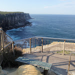
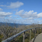


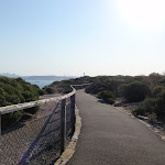


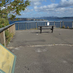


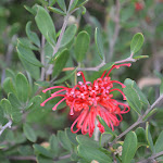
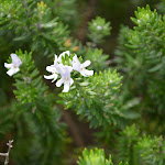


North Head Scenic Drive car park


(0km) North Head Scenic Drive car park → Start of Fairfax track
10 m
0m
0m
Very easy
From the North Head Scenic Drive car park, this walk follows the ‘Fairfax walking track’ sign[5] across the pedestrian crossing and up the small ramp[6]

. The walk leads past the ‘Welcome to North Head’ information sign[7], then between the timber bollards[8] to the intersection marked with the metal ‘Fairfax walking track’ sign[9].
(0.01km) Start of Fairfax walk → South Pacific (Eastern) Lookout
140 m
3 mins
2m
-8m
Very easy
Turn left: From the intersection, this walk heads gently uphill along the wide path, initially keeping the car park (through the heath) to the left. The path almost immediately leads past a seat

(on the left) and leads gently uphill for about 30m to go over a rise then starts heading gently downhill, where the path bends right[10]. About 90m past this bend the path leads to a 3-way intersection above South Pacific (Eastern) Lookout.
(0.15km) South Pacific (Eastern) Lookout int. → South Pacific (Eastern) Lookout
10 m
0m
-1m
Very easy
Turn left: CURRENTLY CLOSED. From the intersection, this walk heads directly towards the ocean views along the asphalt path[11]. The path then comes to the top of some steps, where there are great views[12]. Continue down the stairs to come to the formal fenced lookout[13] and wonderful cliff views. At the end of this side trip, retrace your steps back to the main walk then Turn left.
South Pacific (Eastern) Lookout

From this lookout, you can enjoy great views north along the coastal cliff line and as far as the horizon across the South Pacific Ocean. With a fenced cliff edge and a nice seat, this is a great spot to sit and soak up the views. In 2017 part of this lookout was closed and fenced off due to cliff instability, you can still enjoy the view from behind the fence
(0.15km) South Pacific (Eastern) Lookout int. → Old Gun Emplacement
120 m
2 mins
1m
-3m
Very easy
Old Gun Emplacement
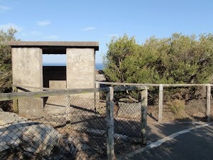
This small concrete building[17][18] was used as a gunning placement and bunker for those who would keep watch over Sydney Harbour during World War Two. It was built in the 1920s (prior to the war), one of several new fortifications built at the time, the first since federation. Access to the building is via an 82cm wide entry, up two (5cm and 15cm) steps and into a 2.4×2.1m room.
(0.27km) Old Gun Emplacement → North Head (Southern) Lookout int.
60 m
2 mins
0m
-18m
Very easy
(0.32km) North Head (Southern) Lookout int. → North Head (Southern) Lookout
20 m
1 mins
1m
-9m
Very easy
North Head (Southern) Lookout
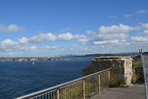
This lookout is on the southern edge of North Head and provides a great view that spans from Sydney city in the distance[24] (to the south), around the South Pacific Ocean[25] (to the east). You will notice a large white pole with a green light[26], which helps ships navigate and avoid the headland as they sail into Sydney Harbour. The lookout has a 1.18m high fence/railing around the edge.
In 2017 part of this lookout was closed and fenced off due to cliff instability, you can still enjoy the view from behind the fence[27].
In 2017 part of this lookout was closed and fenced off due to cliff instability, you can still enjoy the view from behind the fence[27].
(0.32km) North Head (Southern) Lookout int. → Fairfax Lookout intersection
170 m
5 mins
20m
-18m
Very easy
Turn right: From the intersection near North Head (Southern) Lookout, this walk follows the main footpath[28] gently downhill keeping the fence and ocean to the left. The path leads beside a section of nearly bald cliff top opening up wide ocean views[29] for nearly 150m to come to a 3-way intersection[30] (with the steps on track on the left).
Continue straight: From the intersection, this walk follows the footpath distinctly uphill[31], initially keeping the ocean (and step track) to the left. The path leads up the slope for 30m to come to a large 3-way intersection marked with a ‘Fairfax Lookout’ plaque[32] (on the left).
Continue straight: From the intersection, this walk follows the footpath distinctly uphill[31], initially keeping the ocean (and step track) to the left. The path leads up the slope for 30m to come to a large 3-way intersection marked with a ‘Fairfax Lookout’ plaque[32] (on the left).
(0.49km) Int of Fairfax lookout and loop track → Fairfax Lookout
50 m
2 mins
2m
-20m
Very easy
Turn left: From the intersection, this walk follows the wide footpath gently downhill[33] towards the upper Fairfax lookout area to find an intersection just before the seat[34]

.
Veer right: From the upper Fairfax Lookout, this walk heads gently down the ramped footpath[35] (between two metal handrails) for about 30m to come to the lower Fairfax Lookout platform[36] (with a seat on the right

). At the end of this side trip, retrace your steps back to the main walk then Veer left.
Fairfax Lookout
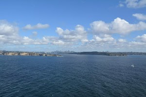
Fairfax Lookout is a great vantage point to enjoy the entrance to Sydney Harbour[37], the majestic cliff line[38] and the city skyline in the distance. It is a great reminder of how much bushland there is in the great city. This is a good vantage point for whale watching when the Humpback and Southern Right whales migrate along the coast. The whales usually head north in June-July to a warmer climate for breeding and return to the food-rich Antarctic waters in August-October, where they remain for the summer.
There is a seat
There is a seat
at the upper and lower viewing areas. The lookout has a 1.2m high metal fence along the edge. A small section of the lower lookout was closed[39] in 2017 due to cliff instability.
(0.49km) Int of Fairfax lookout and loop track → North Head Scenic Drive car park
270 m
6 mins
22m
0m
Very easy
Veer right: From the intersection, this walk heads gently uphill along the footpath keeping the timber fence to the left[40]. The path winds gently uphill for just shy of 120m to come to an intersection with a dirt trail[41] (on the left).
Continue straight: From the intersection, this walk heads gently uphill following the asphalt footpath[42] as it winds through the heath. After 130m the path leads past a timber seat
Continue straight: From the intersection, this walk heads gently uphill following the asphalt footpath[42] as it winds through the heath. After 130m the path leads past a timber seat

(on the right)[43] and then comes to an intersection near the car park and road (on the left)
Turn left : From the intersection, this walk heads towards the car park, between the timber bollards. The walk leads past the ‘Welcome to North Head’ information sign[44] and down the small ramp[45]
to the pedestrian crossing at the North Head Scenic Drive car park.
Maps for the Fairfax Walk walk
You can download the PDF for this walk to print a map.
These maps below cover the walk and the wider area around the walk, they are worth carrying for safety reasons.
| Sydney Heads | 1:25 000 Map Series | 91302N SYDNEY HEADS | NSW-91302N |
| Sydney | 1:100 000 Map Series | 9130 SYDNEY | 9130 |
Cross sectional view of the Fairfax Walk bushwalking track
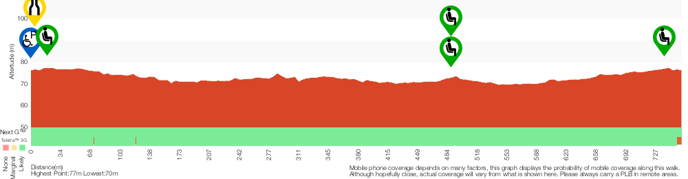
Analysis and summary of the altitude variation on the Fairfax Walk
Accessibility summary information for the Fairfax Walk
Parking: There are 1 designated accessible parking areas on this walk.
Toilets: There are 0 designated accessible toilets on this walk.
Seats: There are 2 places to sit on this walk.
They are 740m apart.
Hazards: There are 0 specific noteable accessability related hazards on this walk.
Accessibility Details

Found 0m into this walk


Overview of this walks grade – based on the AS 2156.1 – 2001
Under this standard, a walk is graded based on the most difficult section of the walk.
| Length | 762 m | ||
| Time | 30 mins | ||
| . | |||
| Grade 1/6 Very easy |
AS 2156.1 | Gradient | Flat, no steps (1/6) |
| Quality of track | Smooth and hardened path (1/6) | ||
| Signs | Clearly signposted (1/6) | ||
| Experience Required | No experience required (1/6) | ||
| Weather | Weather generally has little impact on safety (1/6) | ||
| Infrastructure | Generally useful facilities (such as fenced cliffs and seats) (1/6) |
Some more details of this walks Grading
Here is a bit more details explaining grading looking at sections of the walk
Gradient
This whole walk, 760m is flat with no steps.
Quality of track
This whole walk, 760m follows a smooth and hardened path.
Signs
This whole walk, 760m is clearly signposted.
Experience Required
This whole walk, 760m requires no previous bushwalking experience.
weather
This whole walk, 760m is not usually affected by severe weather events (that would unexpectedly impact safety and navigation).
Infrastructure
This whole walk, 760m is close to useful facilities (such as fenced cliffs and seats).
Similar walks
A list of walks that share part of the track with the Fairfax Walk walk.
Other Nearby walks
A list of walks that start near the Fairfax Walk walk.
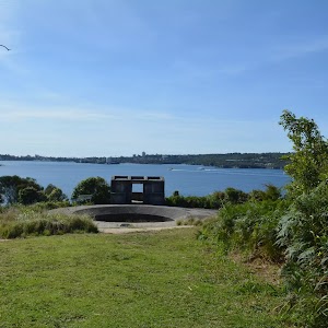
762 m Return
30 mins
Moderate track
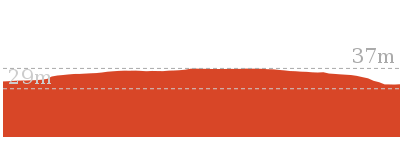
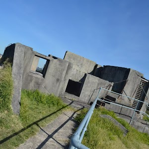
664 m Return
30 mins
Easy track
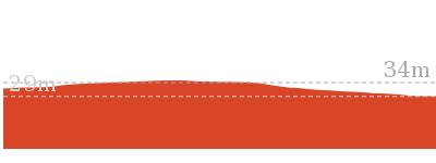
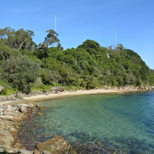
930 m Return
30 mins
Hard track
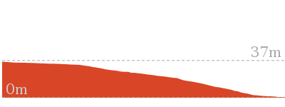
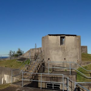
1.9 km Circuit
1 Hr
Moderate track
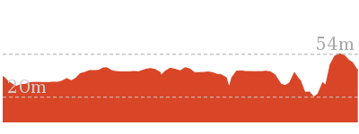
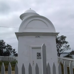
1.7 km Return
1 Hr
Moderate track
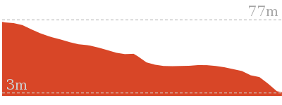

60 m Return
3 mins
Moderate track

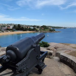
358 m Return
15 mins
Easy track
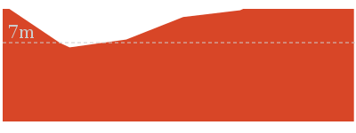
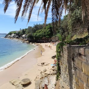
992 m Return
30 mins
Moderate track
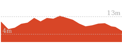
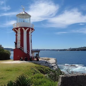
1.7 km Circuit
45 mins
Easy track
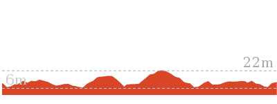
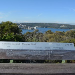
142 m Return
15 mins
Very easy
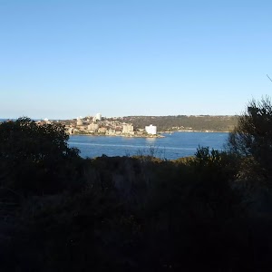
2.5 km Circuit
1 Hr
Hard track
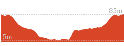
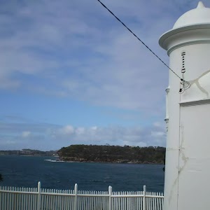
3.6 km Return
2 hrs
Moderate track
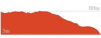
Plan your trip to and from the walk here
The Fairfax Walk walk starts and ends at the North Head Scenic Drive car park (gps: -33.821232, 151.2997)
Your transport options to North Head Scenic Drive car park are by;
![]() Bus. (get details)
Bus. (get details)
![]() Car. Parking fees apply in the area.
Car. Parking fees apply in the area.
(get details)
Short URL = http://wild.tl/9i
Gallery images
There are other downloads I am still working on.
You will probably need to login to access these — still all free.
* KML (google earth file)
* GPX (GPS file)
Special Maps/ brochures
* A3 topo maps
* PDF with Lands Topo map base
* PDF with arial image (and map overlay)
I wanted to get the main site live first, this extra stuff will come in time.
Happy walking
Matt 🙂
Flint and Steel track
And Walk
Flint and Steel track

1 Hr
2.1 km Return
209 m
Moderate track
This walk follows a scenic route to the secluded Flint and Steel Beach, which provides views across the Hawkesbury River to landmarks such as Lion Island, Patonga and Box Head. The walk passes through palm, pine and grass tree forests. There is a great diversity of flora and some fantastic sandstone rock formations along the way.


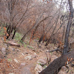

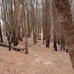

(0km) Flint and Steel carpark → Signpost at saddle
330 m
8 mins
1m
-57m
Moderate track
From the back of the car park, the walk follows the ‘Flint and Steel Track’ sign along the bush track heading down through the bush. The walk drops down some stairs and turns right at the old ‘Ku-ring-gai Chase National Park’ sign, then left down the side of the hill. After about 100m, the walk continues down a set of stairs and then down the bush track to the signposted intersection.
(0.33km) Signpost at Saddle → Flint and Steel beach
740 m
21 mins
35m
-116m
Moderate track
Veer right: From intersection, this walk follows the ‘Flint and Steel Beach 700m’ arrow through a palm grove, along the ridge, with views across Hawkesbury River to Lion Island. The track runs parallel to rock formations on the left before winding its way through the trees and down the boardwalk, with the large rocks to the left. Soon the track heads through some pine trees and comes to an intersection of a bush track, near some large boulders on the left.
Continue straight: From the intersection, this walk follows the track heading straight down the hill towards the beach, splitting for a about 10m before coming to a rock shelf above the waterline. From here, the track turns right and follows this rock shelf for about 20m, onto Flint and Steel Beach.
Continue straight: From the intersection, this walk follows the track heading straight down the hill towards the beach, splitting for a about 10m before coming to a rock shelf above the waterline. From here, the track turns right and follows this rock shelf for about 20m, onto Flint and Steel Beach.
Flint and Steel Beach

Flint and Steel Beach, Ku-ring-gai National Park, is a small north-east facing stretch of sand. The beach is hemmed in by prominent headlands on either side, and backed by a grassy hill. A seat on the grassy hill offers views over the Hawkesbury River to Patonga and Lion Island, with Box Head in the background.
Maps for the Flint and Steel track walk
You can download the PDF for this walk to print a map.
These maps below cover the walk and the wider area around the walk, they are worth carrying for safety reasons.
| Broken Bay | 1:25 000 Map Series | 91301N BROKEN BAY | NSW-91301N |
| Ku-ring-gai Chase National Park Tourist Map | 1:40 000 Map Series | CMA Ku-ring-gai Chase National Park Tourist Map | CMA Ku-ring-gai Chase National Park Tourist Map |
| Sydney | 1:100 000 Map Series | 9130 SYDNEY | 9130 |
Cross sectional view of the Flint and Steel track bushwalking track
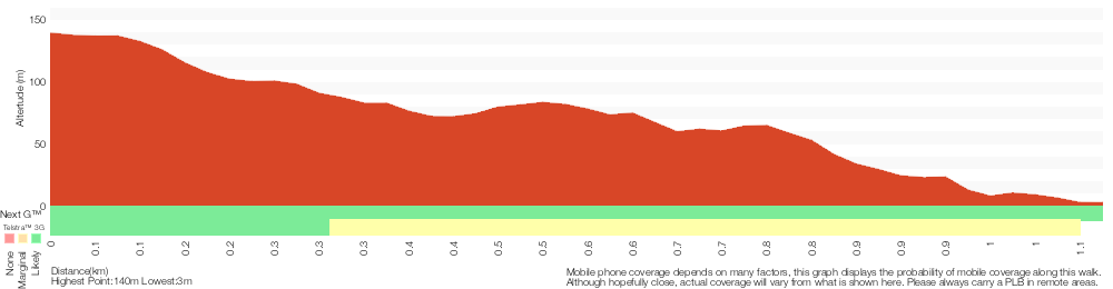
Analysis and summary of the altitude variation on the Flint and Steel track
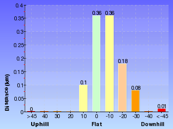
Overview of this walks grade – based on the AS 2156.1 – 2001
Under this standard, a walk is graded based on the most difficult section of the walk.
| Length | 2.1 km | ||
| Time | 1 Hr | ||
| . | |||
| Grade 3/6 Moderate track |
AS 2156.1 | Gradient | Short steep hills (3/6) |
| Quality of track | Formed track, with some branches and other obstacles (3/6) | ||
| Signs | Directional signs along the way (3/6) | ||
| Experience Required | Some bushwalking experience recommended (3/6) | ||
| Weather | Storms may impact on navigation and safety (3/6) | ||
| Infrastructure | Limited facilities, not all cliffs are fenced (3/6) |
Some more details of this walks Grading
Here is a bit more details explaining grading looking at sections of the walk
Gradient
This whole walk, 1.1km has short steep hills.
Quality of track
This whole walk, 1.1km follows a formed track, with some branches and other obstacles.
Signs
Around 740m of this walk has directional signs at most intersection, whilst the remaining 330m is clearly signposted.
Experience Required
Around 590m of this walk requires some bushwalking experience, whilst the remaining 490m requires no previous bushwalking experience.
weather
Around 590m of this walk is affected by storms that may impact your navigation and safety, whilst the remaining 490m is not usually affected by severe weather events (that would unexpectedly impact safety and navigation).
Infrastructure
This whole walk, 1.1km has limited facilities (such as not all cliffs fenced).
Similar walks
A list of walks that share part of the track with the Flint and Steel track walk.
1.9 km Return
1 Hr
Hard track
2.8 km Circuit
1 hr 30 mins
Very experienced only
8.6 km Circuit
5 hrs
Hard track
Other Nearby walks
A list of walks that start near the Flint and Steel track walk.
403 m Circuit
30 mins
Moderate track
1.1 km Circuit
45 mins
Moderate track
3.7 km Return
1 hr 30 mins
Hard track
3.5 km Circuit
1 hr 45 mins
Hard track
1.9 km Return
1 Hr
Moderate track
810 m Circuit
30 mins
Moderate track
238 m Return
10 mins
Easy track
8.2 km Return
3 hrs
Hard track
5.9 km Circuit
3 hrs
Hard track
5.6 km Return
2 hrs 30 mins
Moderate track
1.4 km Circuit
45 mins
Moderate track
5.4 km Circuit
3 hrs
Hard track
Plan your trip to and from the walk here
The Flint and Steel track walk starts and ends at the Flint and Steel carpark (gps: -33.578863, 151.28879)
Your main transport option to Flint and Steel carpark is by;
![]() Car. A park entry fee is required for driving into the park.
Car. A park entry fee is required for driving into the park.
(get details)
Short URL = http://wild.tl/fasbw
Gallery images
There are other downloads I am still working on.
You will probably need to login to access these — still all free.
* KML (google earth file)
* GPX (GPS file)
Special Maps/ brochures
* A3 topo maps
* PDF with Lands Topo map base
* PDF with arial image (and map overlay)
I wanted to get the main site live first, this extra stuff will come in time.
Happy walking
Matt 🙂
Elvina Bay Circuit
And Walk
Elvina Bay Circuit

2 hrs 30 mins
4.5 km Circuit
201 m
Hard track
This walk takes you down to an isolated waterside community, where you can amble along, looking at homes and a historic Grave Site. From Elvina Track Car Park, the vegetation changes from scrubby bush to she oak and large eucalyptus as you decend to the waters edge. The walking is mostly along a management trail, however the return trip follows a narrow track. Side trips include an aboriginal engraving site, a 25m waterfall and a few other view points. Please remember you are visiting a small community please respect the privacy of the local people.
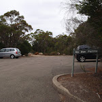

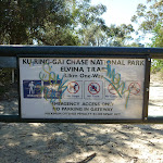
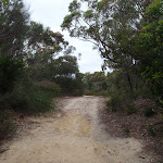
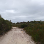


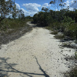


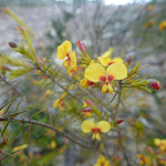
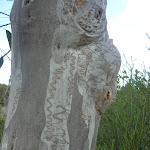


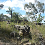
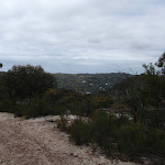
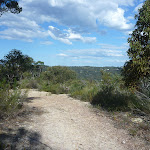

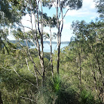

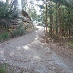

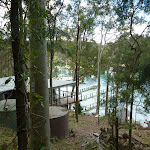


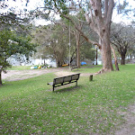
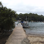


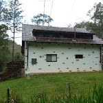
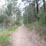
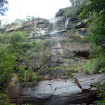
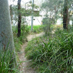


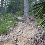
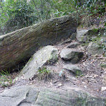
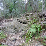


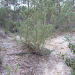

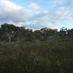

(0km) Elvina Track carpark → Int of Elvina and Engravings Tracks
160 m
3 mins
0m
-1m
Easy track
From Elvina Track car park[1] (on West Head Rd, 1.3km north of General San Martin Dr), this walk follows the management trail around the ‘Elvina Track’ locked gate[2], then past the ‘Elvina Track’ map sign[3] (on the left). This walk continues along the management trail tending right[4] through the scrubby bush[5]. About 70m after leaving the locked gate, the walk comes to an intersection with a narrow track[6] (on your right).
(0.16km) Int of Elvina and Engravings Tracks → Rock Platform
90 m
2 mins
2m
0m
Moderate track
Turn right: From the intersection[7], this walk leaves the management trail and heads slightly uphill along the narrow track[8] through low heath. After about 50m, the track leads right at a faint Y-intersection[9] and soon comes to the northern edge of a large rock platform[10]. Upon reaching the rock platform, there is a small eucalyptus[11] on your right and further left there is an engraving of an emu[12]. At the end of this side trip, retrace your steps back to the main walk then Turn right.
Aboriginal Engraving Rock Platform
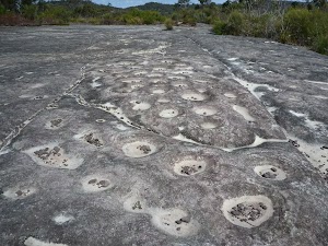
On the northern end of the rock platform are rock carvings of an emu, large fish and a giant whale. Further to the south, the rock platform contains rock carvings of shields, wallabies, fish, eels, and other shapes that are not easily classified. The entire rock platform appears to have a rare erosional feature called tessellation. This occurs over many thousands of years, resulting in a rock surface that is eroding at different rates, creating divot holes and depressions. More info.
(0.16km) Int of Elvina and Engravings Tracks → Int of Elvina and Fredericks Tracks
130 m
2 mins
0m
-2m
Easy track
Continue straight: From the intersection[15], this walk heads east following the management trail gently downhill, while keeping the lower heath on your right[16]. After about 45m, the trail leads over a water bar (hump) then comes to an intersection[17] with a faint track on the left. This faint track looks like a water course and is marked with a cairn[18].
(0.29km) Int of Elvina and Fredericks Tracks → Int of Elvina Track and Wirringulla Avenue
1.7 km
34 mins
16m
-151m
Moderate track
Continue straight: From the intersection[19], this walk follows the management trail east[20], soon tending left, then leading gently downhill over a number of water bars[21]. The trail levels out after about 200m, giving distant views of the ocean (on your right)[22]. This walk continues for a further 400m to find more distant views of the ocean (on the left)[23]. Here the walk turns sharply to the right[24], narrows and steepens for 500m with a noticeable change in vegetation. The vegetation changes from small scrubby eucalyptus to she oak and larger eucalyptus. The trail then comes to a yellow painted steel post[25] (on the left) with distant water views (to the left)[26]. Here the trail is concreted[27] for about 110m, as the trail steepens, winding down through two switch backs[28]. From here the dirt trail continues moderately steeply down over several dirt humps[29] to come to a T-intersection[30] with power lines overhead and directly ahead a house and ocean views.
(1.96km) Int of Elvina Track and Wirringulla Avenue → Top of Elvina Bay Park
410 m
9 mins
14m
-34m
Easy track
Turn left: From the intersection[31], this walk follows the management trail that heads gently downhill[32], keeping the power lines and water to your right. The trail continues amongst houses and bush for about 400m to come to an intersection with a footpath[33] (on your right). From here you can see an open grassy area[34] and rope swing down to the right.
Elvina Bay Park
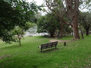
Elvina Bay Park is located on the western shores of the Pittwater, with views out to Elvina Bay and Scotland Island. A good place to stop and rest, Elvina Bay park has two park benches, grassy areas and a great rope swing. There is also a public jetty and ferry wharf. Elvina Bay has a bush fire brigade building[36] and notably this area encountered the 1994 bush fires . (No drinking water or public toilets are available here). More info.
(2.38km) Top of Elvina Bay Park → Int of Wirringulla Avenue and Fredericks Track
350 m
7 mins
15m
-6m
Moderate track
Continue straight: From the intersection, this walk follows the management trail downhill, passing a wide trail (on the right) and crossing a culverted creek after about 25m. This walk continues to follow the trail past houses to the left and right for about 170m, before crossing another culverted creek. This walk then tends right, moderately uphill for about 120m (with ocean views to the right) before leveling out and passing a green electricity box (on the right). This walk continues for about 15m to the intersection with a faint track on the left (opposite the German-looking white house and concrete electricity pole).
(2.72km) Int of Wirringulla Avenue and Fredericks Track → Waterfall
530 m
15 mins
65m
-23m
Hard track
Continue straight: From the intersection, this walk follows the management trail downhill, keeping the houses on your right. This walk follows the trail, passing a side trail (on the right) after about 40m, continuing left and gently uphill. This walk follows the trail for about 30m to a Y-intersection, continuing left and moderately steeply uphill (keeping power lines to the right). This walk continues along the narrowing trail for about 280m (with views of houses and Lovetts Bay on the right), until coming to the end of the management trail (where there is a narrow track ahead and a ‘No Dogs’ sign).
Continue straight: From the end of the management trail, this walk follows the narrow track[38], keeping the hill to the left (with branches and rocks over the track[39]). This walk continues along the track[40] for about 180m, until coming to the waterfall, where a short scramble[41] is required to climb down to the waterfall[42]. At the end of this side trip, retrace your steps back to the main walk then Turn right.
Continue straight: From the end of the management trail, this walk follows the narrow track[38], keeping the hill to the left (with branches and rocks over the track[39]). This walk continues along the track[40] for about 180m, until coming to the waterfall, where a short scramble[41] is required to climb down to the waterfall[42]. At the end of this side trip, retrace your steps back to the main walk then Turn right.
Lovett Bay Waterfall
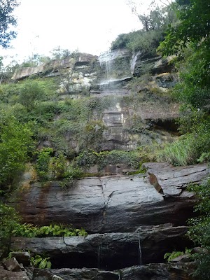
This waterfall is a 25m single fall waterfall, which falls onto large rocks and sand at its base. The waterfall is set in moist bush, with ferns and moss surrounding it. This waterfall is a good place to sit on a hot day. (Be careful while climbing down and up the large rocks, if accessing the base of the waterfall). More info.
Fredericks Grave
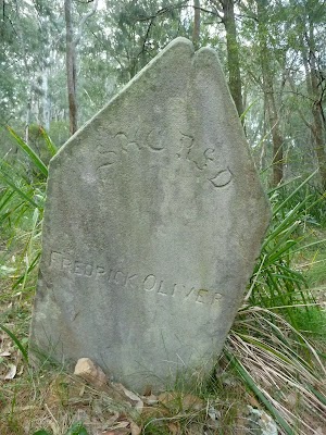
Frederick’s Grave is the grave site of Frederick Oliver. This grave site consists of a sandstone head stone and foot stone. The Olivers made their home in the area, cutting valuable timber and establishing an orchard. This grave of one of their children, Frederick, who was accidentally killed in 1867. More info.
(2.74km) Fredericks Grave → Int of Fredericks and Grasstree Tracks
310 m
13 mins
78m
-4m
Hard track
(3.05km) Int of Fredericks and Grasstree Tracks → Lovetts Bay Viewpoint
110 m
2 mins
0m
-12m
Hard track
Turn right: From the intersection[50], this walk follows the track east[51] and slightly uphill initially, where the track levels out, while swishing through grass trees[52](and passing a television aerial[53]) for about 100m. The track then continues for about 20m to find an unfenced cliff[54] and viewpoint[55]. At the end of this side trip, retrace your steps back to the main walk then Turn right.
Lovetts Bay Viewpoint
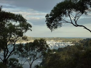
This unfenced viewpoint offers fabulous views of much of the Pittwater and surrounding area, including Lovetts Bay to the north, Scotland Island to the east and Bayview to the south. There are significant steep drops and a large chasm at the viewpoint – care should be taken.
(3.05km) Int of Fredericks and Grasstree Tracks → Int of Fredericks and Lovetts Pool Tracks
110 m
3 mins
12m
-5m
Hard track
Continue straight: From the intersection[56], this walk follows the track west and slightly uphill for about 40m to a Y-intersection[57] (to the right is an unfenced lookout[58]). This walk continues to the left, following the track west for about 70m, until coming to a Y-intersection[59] (with an eroded track leading gently down to the right[60], to Lovetts Pool).
(3.16km) Int of Fredericks and Lovetts Pool Tracks → Lovett Pools
170 m
4 mins
7m
-6m
Hard track
Turn right: From the intersection, this walk follows the eroded track[61] north-west gently downhill. The track leads directly away from the large angophora trees[62] through the dense banksia forest[63]. After about 150m, the track leads to a small creek bed on a large sandstone platform[64]. (Another faint track leads further downstream on the south side of the creek and visits the pools[65]). Be aware of the many unfenced and slippery cliff edges[66]. At the end of this side trip, retrace your steps back to the main walk then Turn right.
Lovett Pools
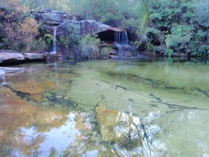
Lovett Pools is the informal name for a lovely set of water holes[67] and cascades[68][69] at the top of a cliff, above Lovett Bay[70]. The unnamed creek works its way along a sandstone platform forming a couple of larger pools and a series of cascades. There are also many smaller carved holes[71] in the rock, adding interest for the budding geologists. The creek flows over a large cliff[72] forming a tall waterfall just before the Pittwater. The rocks are slippery and there are many cliff edges, please take care.
(3.16km) Int of Fredericks and Lovetts Pool Tracks → Elvina Track carpark
1.4 km
27 mins
62m
0m
Hard track
Continue straight: From the intersection[73], this walk follows the eroded track west and gently uphill over exposed roots[74]. This walk continues along the track through scrubby bush, passing a large heath clearing[75] after about 430m (on the left). This walk then continues to follow the track for about 500m, until coming to a T-intersection with a management trail[76].
Turn right: From the intersection[77], this walk follows the management trail gently uphill[78] and over a water bar (hump), while keeping the lower heath to the left. After about 45m, the trail comes to an intersection[79] with a faint track on the left.
Continue straight: From the intersection[80], this walk follows the management trail, while keeping the taller heath[81] on your right. The management trail tends left through the scrubby bush[82] then heads around the locked gate[83] to find the ‘Elvina Track’ car park[84] (on West Head Rd, 1.3km north of General San Martin Dr).
Maps for the Elvina Bay Circuit walk
You can download the PDF for this walk to print a map.
These maps below cover the walk and the wider area around the walk, they are worth carrying for safety reasons.
| Mona Vale | 1:25 000 Map Series | 91301S MONA VALE | NSW-91301S |
| Ku-ring-gai Chase National Park Tourist Map | 1:40 000 Map Series | CMA Ku-ring-gai Chase National Park Tourist Map | CMA Ku-ring-gai Chase National Park Tourist Map |
| Sydney | 1:100 000 Map Series | 9130 SYDNEY | 9130 |
Cross sectional view of the Elvina Bay Circuit bushwalking track
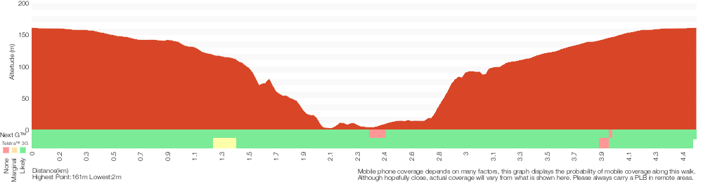
Analysis and summary of the altitude variation on the Elvina Bay Circuit
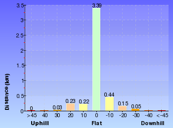
Overview of this walks grade – based on the AS 2156.1 – 2001
Under this standard, a walk is graded based on the most difficult section of the walk.
| Length | 4.5 km | ||
| Time | 2 hrs 30 mins | ||
| . | |||
| Grade 4/6 Hard track |
AS 2156.1 | Gradient | Short steep hills (3/6) |
| Quality of track | Rough track, where fallen trees and other obstacles are likely (4/6) | ||
| Signs | Minimal directional signs (4/6) | ||
| Experience Required | Moderate level of bushwalking experience recommended (4/6) | ||
| Weather | Weather generally has little impact on safety (1/6) | ||
| Infrastructure | Limited facilities (such as cliffs not fenced, significant creeks not bridged) (4/6) |
Some more details of this walks Grading
Here is a bit more details explaining grading looking at sections of the walk
Gradient
Around 2.3km of this walk has short steep hills, whilst the remaining 2.2km has gentle hills with occasional steps.
Quality of track
2.7km of this walk follows a clear and well formed track or trail and another 1.1km follows a rough track, where fallen trees and other obstacles are likely. Whilst another 440m follows a formed track, with some branches and other obstacles and the remaining 350m follows a smooth and hardened path.
Signs
3km of this walk is clearly signposted and another 1.5km has minimal directional signs. The remaining (20m) has directional signs at most intersection.
Experience Required
3km of this walk requires no previous bushwalking experience and another 1.4km requires some bushwalking experience. The remaining (110m) requires a leader a with moderate level of bushwalking experience.
weather
This whole walk, 4.5km is not usually affected by severe weather events (that would unexpectedly impact safety and navigation).
Infrastructure
3km of this walk is close to useful facilities (such as fenced cliffs and seats) and another 1.5km has limited facilities (such as cliffs not fenced, significant creeks not bridged). The remaining (20m) has limited facilities (such as not all cliffs fenced).
Similar walks
A list of walks that share part of the track with the Elvina Bay Circuit walk.
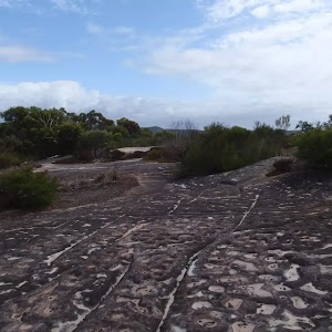
508 m Return
15 mins
Moderate track
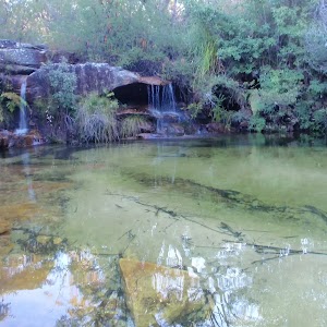
3 km Return
1 hr 15 mins
Hard track
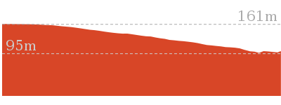
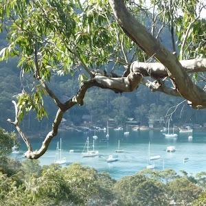
4.8 km Return
2 hrs
Moderate track
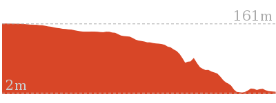
Other Nearby walks
A list of walks that start near the Elvina Bay Circuit walk.
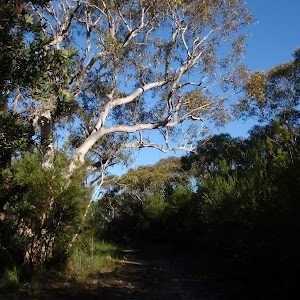
4 km Circuit
1 hr 30 mins
Moderate track
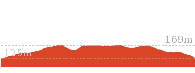
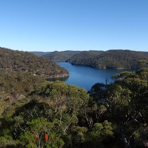
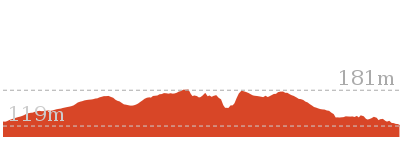
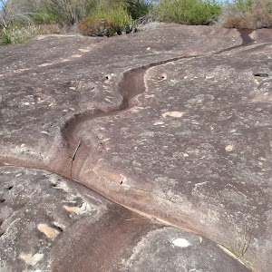
9.9 km Return
3 hrs 30 mins
Hard track
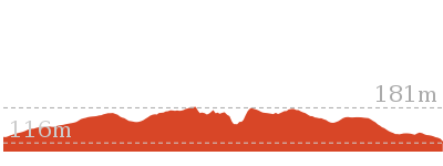
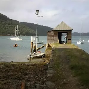
8.4 km Circuit
4 hrs
Moderate track
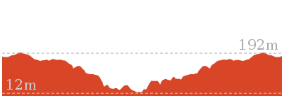
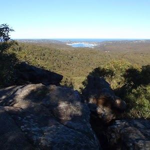
1.4 km Return
40 mins
Moderate track
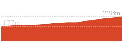
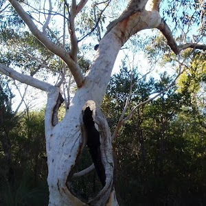
3.8 km Return
1 hr 30 mins
Moderate track
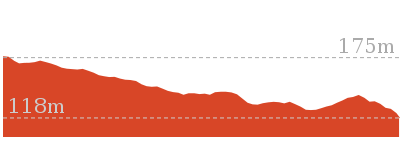
6.7 km Return
2 hrs 30 mins
Moderate track
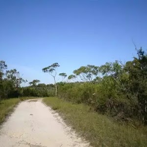
7.6 km Return
3 hrs
Moderate track
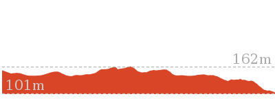
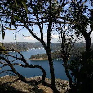
6.8 km Return
2 hrs 30 mins
Moderate track
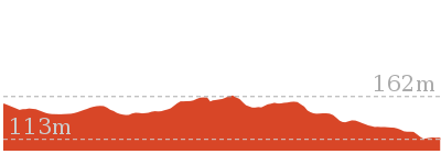
2.2 km Return
1 hr 15 mins
Hard track
1.9 km Return
45 mins
Moderate track
2.4 km Return
1 Hr
Hard track
Plan your trip to and from the walk here
The Elvina Bay Circuit walk starts and ends at the Elvina Track carpark (gps: -33.643268, 151.26214)
Your main transport option to Elvina Track carpark is by;
![]() Car. A park entry fee is required for driving into the park.
Car. A park entry fee is required for driving into the park.
(get details)
Short URL = http://wild.tl/z
Gallery images
There are other downloads I am still working on.
You will probably need to login to access these — still all free.
* KML (google earth file)
* GPX (GPS file)
Special Maps/ brochures
* A3 topo maps
* PDF with Lands Topo map base
* PDF with arial image (and map overlay)
I wanted to get the main site live first, this extra stuff will come in time.
Happy walking
Matt 🙂
Centre Track
And Walk
Centre Track

2 hrs 30 mins
6.7 km Return
195 m
Moderate track
(0km) Mccarrs Creek Rd → Rocky Outcrop
1.5 km
26 mins
18m
-47m
Moderate track
The track starts on Coal and Candle Drive, about 20 metres in from the toll gate.
From the intersection, the walk passes around the gate (signposted ‘Centre Track’) and follows the management trail along the ridge line. About halfway along the Centre track walk you will find the Rocky Outcrop (there are several rocky outcrops along the walk) on the Southern side of the track, opposite a rocky knoll with a small overhang cave. From here, there are nice views south across the valley.
(1.48km) Rocky Outcrop → Tessellated Pavement
1.3 km
26 mins
43m
-28m
Moderate track
Continue straight: From the Rocky Outcrop, the walk follows the management trail east. After a short distance, the walk comes to an area of Tessellated Pavement, at another rocky outcrop.
(2.83km) Tessellated Pavement → General San Martin Drive
520 m
11 mins
13m
-46m
Moderate track
Turn right: From the Tessellated Pavement, this walk heads south, following the main track down the hill. The track winds its way down the hill in a easterly direction. There is a locked gate just before General San Martin Drive.
Maps for the Centre Track walk
You can download the PDF for this walk to print a map.
These maps below cover the walk and the wider area around the walk, they are worth carrying for safety reasons.
| Hornsby | 1:25 000 Map Series | 91304S HORNSBY | NSW-91304S |
| Mona Vale | 1:25 000 Map Series | 91301S MONA VALE | NSW-91301S |
| Ku-ring-gai Chase National Park Tourist Map | 1:40 000 Map Series | CMA Ku-ring-gai Chase National Park Tourist Map | CMA Ku-ring-gai Chase National Park Tourist Map |
| Sydney | 1:100 000 Map Series | 9130 SYDNEY | 9130 |
Cross sectional view of the Centre Track bushwalking track
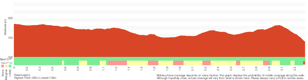
Analysis and summary of the altitude variation on the Centre Track
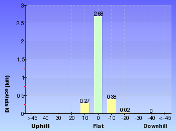
Overview of this walks grade – based on the AS 2156.1 – 2001
Under this standard, a walk is graded based on the most difficult section of the walk.
| Length | 6.7 km | ||
| Time | 2 hrs 30 mins | ||
| . | |||
| Grade 3/6 Moderate track |
AS 2156.1 | Gradient | Short steep hills (3/6) |
| Quality of track | Clear and well formed track or trail (2/6) | ||
| Signs | Directional signs along the way (3/6) | ||
| Experience Required | Some bushwalking experience recommended (3/6) | ||
| Weather | Weather generally has little impact on safety (1/6) | ||
| Infrastructure | Limited facilities, not all cliffs are fenced (3/6) |
Some more details of this walks Grading
Here is a bit more details explaining grading looking at sections of the walk
Gradient
Around 2.8km of this walk has gentle hills with occasional steps, whilst the remaining 520m has short steep hills.
Quality of track
This whole walk, 3.3km follows a clear and well formed track or trail.
Signs
This whole walk, 3.3km has directional signs at most intersection.
Experience Required
Around 2.8km of this walk requires no previous bushwalking experience, whilst the remaining 520m requires some bushwalking experience.
weather
This whole walk, 3.3km is not usually affected by severe weather events (that would unexpectedly impact safety and navigation).
Infrastructure
Around 1.9km of this walk has limited facilities (such as not all cliffs fenced), whilst the remaining 1.5km is close to useful facilities (such as fenced cliffs and seats).
Similar walks
A list of walks that share part of the track with the Centre Track walk.
Other Nearby walks
A list of walks that start near the Centre Track walk.
2.4 km Return
1 Hr
Hard track
5.3 km Return
2 hrs 30 mins
Moderate track
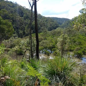
16.1 km Return
6 hrs
Moderate track
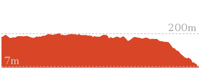
7.2 km One way
2 hrs 45 mins
Moderate track
5.5 km Return
2 hrs
Moderate track
5.2 km Return
1 hr 45 mins
Moderate track
2.5 km Return
1 hr 30 mins
Moderate track
508 m Return
15 mins
Moderate track
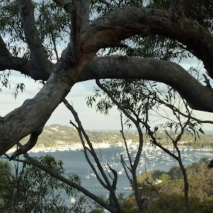
4.5 km Circuit
2 hrs 30 mins
Hard track
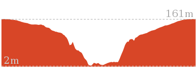
4.8 km Return
2 hrs
Moderate track
3 km Return
1 hr 15 mins
Hard track
Plan your trip to and from the walk here
The Centre Track walk starts and ends at the Mccarrs Creek Rd (gps: -33.665666, 151.23068)
Your main transport option to Mccarrs Creek Rd is by;
![]() Car. A park entry fee is required for driving into the park.
Car. A park entry fee is required for driving into the park.
(get details)
Short URL = http://wild.tl/cent
Gallery images
There are other downloads I am still working on.
You will probably need to login to access these — still all free.
* KML (google earth file)
* GPX (GPS file)
Special Maps/ brochures
* A3 topo maps
* PDF with Lands Topo map base
* PDF with arial image (and map overlay)
I wanted to get the main site live first, this extra stuff will come in time.
Happy walking
Matt 🙂
Comments